Scientific Press International Limited
In Old Babylonia:
Irrigation and Agriculture Flourished
Under the Code of Hammurabi (2000-1600 BC)
Nasrat Adamo1 and Nadhir Al-Ansari2
Abstract
After two centuries after the fall of the last Sumerian dynasty of Ur in 2003BC, the first kingdom of Babylon did appear. The Amorites who were Semitic people who had lived in the west of middle Mesopotamia brought the collapse of Ur itself. They appeared as nomadic clans ruled by fierce tribal chiefs, who forced themselves into lands where they needed to graze their herds. There was no Amorite invasion of southern Mesopotamia as such, but the Amorites ascended smoothly to power in many places, especially during the reign of the last kings of the Ur III dynasty, and so the following Amorite dynasty took over the rule of long-extant city-states such as Isin, Larsa, Eshnunna, and Kish and also established new ones. After a brief periods of an Elamites and old Assyrian empire dominations that took place for only 46 years the Amorite kingdom was firmly established in 2004 BC in Babylon and continued until 1595 BC, known in Mesopotamia’s history as the "Amorite Period". Babylon became the major power in the ancient world during the reign of Hammurabi. It was from then that all parts of southern Mesopotamia came to be known as Babylonia. It was during the reign Babylonia witnessed the great care he had devoted to maintain and expand irrigation networks and keep the prosperity of the empire and even so successfully constructing new canals and dams. When Hammurabi established control over the whole region of Mesopotamia by 1760, and especially the city-states of Sumeria, he restored the irrigation canals there to their best conditions and brought water back to areas of the south that were previously deprived of it. His unification of the entire south and the lands north of Babylon allowed him to dig long canals to the various cities of these lands. The canal he called “Hammurabi-is-the-abundance-of-the-people”, for example, ran by Nippur, Isin, Uruk, Larsa, Ur, and Eridu, and covered a stretch of land extending for a distance of some 160 kilometers. These works brought economic development and increased the wealth of the population to unprecedented levels. Hammurabi’s
1 Consultant Engineer, Norrköping, Sweden.
2 Lulea University of Technology, Lulea.
Article Info: Received: February 10, 2020. Revised: February 15, 2020. Published online: March 30, 2020.
achievement as a lawmaker is specifically highlighted; as he was famous for his “Legal Code” which he had promulgated.
Keywords: Old Babylonia, Irrigation and Agriculture, Hammurabi, Legal Code,
Iraq.
1. Old Babylonia, Irrigation and Agriculture
Two centuries already had passed since the fall of the last Sumerian dynasty of Ur in 2003BC until the first kingdom of Babylon didappear. The collapse of Ur itself was brought about at the hands of the Amorites, which triggered major and important turning point in the history of Mesopotamia. On this account, a brief presentation of the Amorites looks very much justified. The Amorites were Semitic people who had lived in the west of middle Mesopotamia, which included the land of Canaan. They appeared as uncivilized and nomadic clans ruled by fierce tribal chiefs, who forced themselves into lands where they needed to graze their herds. From the early Mesopotamian writings of Sumer, Akkad, and Assyria, it was clear that the Amorites were especially connected with the mountainous region now called Jebel Bishri in northern Syria which is named the "Mountain of the
Amorites”. From the 21st century BC, and possibly triggered by a long major
drought starting about 2200 BC, a large-scale migration of Amorite tribes infiltrated southern Mesopotamia. Some of the Akkadian literature of this era spoke disparagingly of the Amorites which were called (MAR. TU), and implied that they were nomadic and primitive, and even looked to their way of life with disgust and contempt:
“The MAR.TU who knows no grain.... The MAR.TU that knows no house nor
a town, the boors of the mountains.... The MAR.TU that digs up truffles... who does not bend his knees (to cultivate the land), who eat raw meat, who has no house during his lifetime, who is not buried after death”
And add:
"They have prepared wheat and gú-nunuz (grain) as a confection, but an Amorite will eat it without even recognizing what it contains”.
By the time of the last days of the third dynasty of Ur, the immigrating Amorites had become such a force that obliged the Sumerians to construct a 270-kilometre (170 mi) wall from the Tigris to the Euphrates to hold them off. However, this proved to be a futile effort, and they became one of the instruments of the downfall of the third dynasty of Ur. Many Amorite chieftains in southern Mesopotamia aggressively took advantage of the failing kingdom to seize power. There was not an Amorite invasion of southern Mesopotamia as such, but the Amorites ascended to power in many places, especially during the reign of the last kings of the Ur III dynasty. The following Amorite dynasties took over the rule of long-extant city-states such as Isin, Larsa, Eshnunna, and Kish and established new ones.
After a brief period of an Elamites and old Assyrian empire domination that took place within (2050-2004BC) the Amorite kingdom was firmly established
(2004-1595 BC) which is sometimes known as the "Amorite Period" in Mesopotamian history [1]. The small town of Babylon, unimportant both politically and militarily,
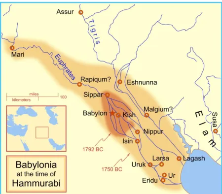
was raised to the status of a minor independent city-state, under Sumu-abum in 1894 BC and this led the way to the rise of the powerful King Hammurabi (1810 BC-1750 BC) who united all the city- states and established the Babylonian Empire, see Figure 19.
Figure 19: Babylonia at the time of Hammurabi.
The heartland of Babylonia was downstream of the present-day Baghdad or better, from the point where the two rivers, Euphrates and Tigris, approach each other so closely that they leave a stretch of only about twenty miles between them. It was not situated in the alluvium plain between the two rivers, but rather on the banks along several courses of the Euphrates that fanned out in a number of channels during the history of the river. At times, Babylonia reached beyond the Tigris, into the flat lands and foothills of the Zagros range; generally along the eastern tributaries of the Tigris. Its political and cultural influence extended upstream, along both rivers, on the Euphrates as far as Mari and beyond, on the Tigris as far as Assur. The two rivers in Babylonia’s high time, as they were in the Sumerian era were also the two arteries which had supported the flourishing agriculture then and there, and it was along their two courses and by the natural or the dug canals, all the city states of the Sumerians and the Babylonian cities were established. However, the two rivers emptied directly into the Persian Gulf, not as the case now, as they both join to form Shatt Al- Arab which did not exist at that time.
Babylon became the major power in the ancient world during the reign of Hammurabi, and it was from then that southern Mesopotamia came to be known as Babylonia. The rise of the Amorite kingdoms in Mesopotamia brought about deep
and lasting repercussions in its political, social and economic structure, especially in southern Mesopotamia. The religious, ethical, technological, scientific and artistic directions in which Mesopotamia had been developing since the 4th millennium BC were not greatly affected by the Amorites' hegemony. They continued to worship the Sumero-Akkadian gods, and the older Sumerian myths and epic tales were piously copied, translated, or adapted, generally with only minor alterations. In Babylonia, agriculture thrived and the Sumerian ways and means were developed further. The reign of Hammurabi witnessed the great care he devoted to maintain and expand irrigation networks, who even developed articles in his famous code to protect them.
The new empire which had its capitol established in Babylon had already received from the Sumerians very advanced agricultural base in the form of huge irrigation canal networks, dams and agricultural knowledge, so they did not have to add much on that. But due to the changing and shifting of the Euphrates and Tigris Rivers, they had to dig new feeder canals and build new dams each time these two rivers changed their courses; which happened often due to their violent and frequent floods. One historical example of such a flood is the one which had occurred between 1865 BC and 1850 BC whereby; the Euphrates changed its course in easterly direction and followed the course of the then “Babel River” branch, believed to be the present days “Shatt- Al Hillah” branch. This change resulted in cutting off all the canals off- taking from the old course, and required digging of new canals [2]. This behavior of the Euphrates is characteristic of fluvial rivers, and
it is a well-known fact that it had changed its course many times in history. The last of such events was at the end of the nineteen century due to silting up of “Shatt
Al Hillah” branch head reach and concentrating the flow in the second branch “Al Hindiya”. This was the reason behind the construction of Al Hindiya Barrage in
(1911) to divide the flow equitably between the two branches.
King Hammurabi was not only a worrier that united the whole Mesopotamia under his rule, but he was also a keen builder as he undertook a series of public works, including heightening the city walls for defensive purposes and enlarging it, and expanding the temples. It is known that he had built a great bridge across the Euphrates connecting both banks of Babylon city itself [3]. Babylon flourished
during his reign, and it extended over a large area on both banks of the Euphrates as seen from the map in Figure 20 [4].
Hammurabi was convinced, and so his people were, that the good ruler was the one
who would provide agricultural wealth for his people. In southern Mesopotamia where very little rain fell, this meant digging and maintaining irrigation canals to water the field. Boasting of such work one would not be surprised to see such an inscription left by Hammourabi commemorating his works which says:
“I dug the canal Hammurabi-is-the-abundance-of-the-people which brings a profusion of water to the land of Sumer and Akkad”.
As fields in lower Mesopotamia could only be cultivated when irrigated, the digging of a canal was an obvious blessing for all. Again, references to such acts by rulers of this time are numerous, and Hammurabi did not fail in this respect. Therefore, when late in his life he boasted of his accomplishments in the prologue of his code; he wrote speaking of himself as:
“The one who extended the cultivated lands of the city of Dilbat and who filled the granaries for the powerful god Urash.”
Figure 20: Map of Babylon at the Hellenistic age but basically developed in Hammurabi reign showing the bridge on the Euphrates, the nine gates in the
city walls, and the Temples [4].
“Hammurabi” completed many irrigation canals. One of these were the great canal which he dug and called “Nar Hammurabi” or the
Hammurabi-is-the-abundance-of-the-people”, to carry water from the new course of the Euphrates, after the river
had changed its course, down to the city of “Kish” in the direction of “Umma” and then to the city of “Larsa” to empty afterwards in the Gulf.
Hammurabi, as usual, boasts of his work on canals and many of his preserved
the early decades of his reign and even before that, some city- states regularly denied water to their neighbors by diverting it through new channels they had dug, which bypassed their enemies’ cities causing distress and barren lands. When Hammurabi established control over the whole region by 1760 BC, he restored the damage and brought water back to areas of the south that were previously deprived of it. His unification of the entire south of Mesopotamia and the lands north of Babylon, a territory stretching some 400 kilometers from north to south along the Tigris and Euphrates rivers, allowed him to dig long canals to the various cities of this domain. The “Hammurabi-is-the-abundance-of-the-people” canal, for example, ran by
Nippur, Isin, Uruk, Larsa, Ur, and Eridu, and covered a stretch of land extending
for a distance of some 160 kilometers. Pacification brought thus economic development, and increased the wealth of the population [5].
Hammourabi also directed his attention to the maintenance of canals freeing them
from silt and maintaining their discharge, so we see him directing his official representatives in the cities under his rule just to do this. In a letter to Sin- Adenam governor of Larsa, he ordered him to gather all land tenants and users of the “Damanom” canal to dredge it of the accumulated silt, and instructing that this should be completed at the end of the month. In another letter he ordered the same official to complete the dredging of the canal to Uruk within three days as the work was in delay [4].
Hammurabi was also famous for his “Legal Code” or the “Hammurabi Code”,
which we came to know about from an obelisk uncovered in an archeological site in Sousa in Iran in (1909 AD) and is kept now in the Louvre Museum in Paris. Figure 21 shows Hammurabi himself in front of the God Marduk presenting him
with the tablets of the laws inferring the divine power behind them.
The code, although had predecessors from Sumerian times such as Ornimo, Labith
Ishtar, Eshnunna codes, it was more comprehensive and contained specific
punishments and penalties for specific crimes and violations. The code contained 282 articles, and many of these articles were concerned with agriculture and irrigation, which showed the importance of them to the prosperity of Babylon, in addition to Hammurabi’s keen interest in realizing justice. Articles covering agriculture dealt with, among other things, either leasing and cultivating the land, or taking loans for investing in agriculture, and their repayment. These can be seen from articles 42 to article 48, which had prescribed penalties of various magnitudes in case of failure or neglect. Loans were to be paid back by quantities of crop, which should correspond to the loan plus its interests. In case ofdefault, however, it may be repaid in terms of free labour depending on the kind of failure.In the normal case of borrowing a loan by a farmer then payment back the loan to the creditor should cover the amount of the loan and its interests in terms of the planted crop. On the other hand if the crop was lost due to inundation of the land or because of irrigation water shortage, then in that year, he shall not make any return of grain.
Other articles covered the misuse of water as in articles 53, and 55 to 56:
“If a man neglects to strengthen his dyke and does not strengthen it, and a break be made in his dyke, and the water carried away the farm-land, the man in
whose dyke the break has been made shall restore the grain which he has damaged”.
“If a man opens his canal for irrigation and neglects it and the water damages
adjacent fields; he shall pay out grain on the basis of the area of adjacent fields”. “If a man opens up the water, and the water carries away the improvements of an adjacent field; he shall measure out ten Gur of grain per Gur lost”.
Figure 21: Hammurabi presenting his code to the God Marduk.
Moreover, special attention was given to such matters as being careful and avoiding causing damage to the fields by grazing sheep, so articles 57-58 stipulate:
“If a shepherd has not come to agreement with the owner of a field to pasture his sheep on the grass; and if he pastures his sheep on the field without the consent of the owner, the owner of the field shall harvest his field, and the shepherd who has pastured his sheep on the field without the consent of the owner of the field,
shall give over and above twenty GUR of grain per ten GAN to the owner of the field.”
“And if, after the sheep have gone up from the meadow and have crowded their way out (?) of the gate into the public common, the shepherd turns the sheep into the field, and pasture the sheep on the field; the shepherd shall oversee the field on which he pastures and at the time of harvest he shall measure out sixty GUR of grain per ten GAN to the owner of the field”.
Caring for orchards and trees was also covered as seen from articles 59-65, which had stipulated the following:
“If a man cut down a tree in a man's orchard, without the consent of the owner of the orchard, he shall pay one-half mana of silver”.
“If a man gives a field to a gardener to plant as an orchard and the gardener plants the orchard and care for the orchard four years, in the fifth year, the owner of the orchard and the gardener shall share equally; the owner of the orchard shall mark off his portion and take it”.
“If the gardener does not plant the whole field, but leave a space waste, they shall assign the waste space to his portion”.
“If he do not plant as an orchard the field which was given to him, if corn be the produce of the field, for the years during which it has been neglected, the gardener shall measure out to the owner of the field (such produce) on the basis of the adjacent fields, and he shall perform the required work on the field, and he shall restore it to the owner of the field”.
“If the field be unreclaimed, he shall perform the required work on the field, and he shall restore it to the owner of the field and he shall measure out ten GUR of grain per ten GAN for each year”.
“If a man gives his orchard to a gardener to manage, the gardener shall give to the owner of the orchard two-thirds of the produce of the orchard, as long as he is in possession of the orchard; he himself shall take one-third”.
“If the gardener does not properly manage the orchard; and he diminishes the produce, the gardener shall measure out the produce of the orchard on the basis of the adjacent orchards[6], [7].
According to best estimates, the Gur was equivalent to approximately 0.3 liters while one GAN was about 0.6 square meter [8].
Hammurabi was interested in land reclamation and in organizing the agrarian
relations and this was manifested clearly in his code, which stated in one article that waste land which was left to be reclaimed by tenants were to be granted rent-free tenancy for three years. Tenants were to pay a stipulated rent in the fourth year. If the tenant neglected to reclaim the land, the code enacted that he must hand it over in good tilth and fixed a statutory rent. Gardens or plantations were let in the same way and under the same conditions; but for date-groves four years' free tenure was allowed.Similarly, tenancy was organized according to the métayer system was in vogues, especially on temple lands. As for the landlords it was their duty to provide the land, oxen for ploughing and the watering-machines, carting, threshing or other implements, seed corn, and rations for the workmen and fodder for the cattle.The
tenant, or steward, usually had another land of his own. If he stole the seed, rations or fodder, the Code enacted that his fingers should be cut off. If he appropriated or sold the implements, impoverished or sublet the cattle, he was heavily fined, and in default of payment might be condemned to be torn to pieces by the cattle on the field; the rent was as contracted[9].
Following this golden epoch, and as normal with all empires, the old Babylonian Empire started to decline, but it was still looked at with envy by other nomadic Peoples at the edges of the empire due to its richness and prosperity. Finally,
Babylon itself was attacked and sacked by the Hittites in 1595 BC when Hammurabi’s dynasty was falling apart during the reign of its eleventh king
(Shamso-Detanana).
The Hittites led by their King Musili came down from Anatolia, but then retreated to their original homeland shortly afterwards and were replaced after a short period by other people known as the Kassites [10].
The extent of the Babylonian empire at the time of the Kassites invasion is shown in Figure 22 [10]. The Kassites themselves controlled Babylonia for 386 years from
1531 BC until 1155 BC, and established a dynasty based first in Babylon and later in Dur-Kurigalzu near the confluence of the Tigris and Diyala rivers, about 30 kilometres (19 mi) west of the center of present day Baghdad. It was founded by the
Kassites king of Babylon, Kurigalzu, I in the late 15th or early 14th century BC.
The original homeland of the Kassites is not well known. It appears to have been located in the Zagros Mountains, in what is now the Lorestan province of Iran. The circumstances of their rise to power before entering Babylon are unknown due to a lack of documentation during this so-called "Dark Age" period (1595-1531BC), which was due to widespread dislocation. No inscription or document in the
Kassites language has been preserved, an absence that cannot be purely accidental,
suggesting a severe regression of literacy in official circles.
The success of the Kassites was built upon the relative political stability that the
Kassites monarchs achieved. They ruled Babylonia practically without interruption
for almost four hundred years, which is the longest rule by any dynasty in
Babylonian history. Those kings were members of a small military aristocracy but
were efficient rulers and not locally unpopular, and their 400-year reign laid essential groundwork for the development of subsequent Babylonian culture[11].
Figure 22: Babylonia, at the time of the Kassites [10].
The location of old Babylon and Dur- Kurigalzu are shown in the map of Figure 23. This map shows also the old Sumerian cities with their present names as archeological sites given between parentheses. This map even shows the modern cities of Basra, Karbala, Baghdad, and Samara for good reference [12]. In the maps
of Figure 22 and Figure 23 it is worth to note the old courses of the rivers` Tigris, Euphrates; and Karkha which had alsopoured out directly into the Persian Gulf at that period.
Figure 23: Map showing locations of Babylon (20), Dur-Kurigalzu (28) and other old cites of Sumeria with their present archeological sites in parenthesis; in addition to some modern Iraqi cities [12]. Note: The unit of measurement on the scale shown on this map has been corrected from (m.) in the original map to (km.) by the writer, and the notation on the arrow has been also changed showing north from (MIN) to (N).
To the reader of this history, it is of great interest to observe how this part of the world had in so many times attracted outside invaders, who in most cases were ravening barbarians looking for the wealth and rich resources of the Mesopotamian civilizations.It is not surprising, therefore, that the Kassites themselves were thrown out by a new invading wave of people; this time the Elamites (1168 BC-1162B C) who were the new Babylonians.
The Kassites however, should be credited for the fact that during their four hundred years, or so, they had acquired the Babylonian knowledge and utilized it for their own benefit. In engineering they maintained and kept the irrigation works in good and functional conditions. So, they passed this knowledge again to the new
Babylonian dynasty which conquered them and drove them out of Babylonia. These
new Babylonians of the Elamites remained in power for the next 131 years and had eleven of their kings on the throne of the Babylonian Empire until this empire gave in under the increasing pressures of the newly rising empire of Assyria in 931 BC. During the flourishing period of the Babylonian supremacy, major engineering water works were accomplished, either as newly constructed ones or by extending and improving others inherited from earlier periods. While we have not received much written information on who were the kings responsible for these works, archeological findings show that these major works took a long time to be completed; which indicates probably that many successive kings worked on each of them. Such of these large projects were; the Great Nimrud Dam and the Nahrawn
Grand Canal. The dam that was called Nimrod Dam on the Tigris was an earthfill
dam built around 2000 BC., north of Baghdad and was used to prevent erosion and reduce the threat of flooding. The intention was to divert the flow of the river and help irrigate the crops [13]. Historical evidence reveals that the Tigris River in its
course south of the city of Samarra had two branches at a point located at the entry of the river into what may be considered as the beginning of the alluvial plains of Mesopotamia.
The bulk of flow used to flow in the western branch in a southwesterly direction, while the remaining flow went into the eastern smaller channel, and after some 100 kilometers it turned to the east to meet with this eastern branch at a point north of the modern city of Al Kadhimiah. However, later on, and as normal for rives in fluvial deltas changing their courses and taking new channels for many reasons; the Tigris abandoned its main course to flow through the eastern smaller branch; which became the main stream. This event resulted in depriving the other branch from its share and cutting off water supply of the extensive irrigation network depending on it.
Here, there are two different opinions on the reason for this change, the first was held by Sousa [14], in which he claimed that it was brought about by a very high
flood which caused the diversion into the eastern channel which was generally lower than the other one. Sir William Willcocks, the British engineer who had studied the conditions of irrigation in Iraq in the late years of the nineteenth century
for the Ottoman Government, advocated, however, a second opinion. Willcocks believed that; as it was normal for such rivers, both branches were eroding and cutting deeper into their beds due to the general change of the ground grade. In addition, while this process had continued along the eastern branch unhindered, it was stopped at some level in the western branch due to the presence of one bed of very hard rocks, which are most probably conglomerates. This had caused the rising of water level at the head reach above that in the eastern channel and resulted in overflowing of the river into this channel[15]. The ancient engineers had to think of
a way to solve the problem of water shortage along the western bank, and the solution was to build the “Grand Nimrud Dam”.
Things could not have stopped at just building the dam because those same engineers had also to organize the irrigation of the lands along this branch and extending irrigation to all the domains up to the foot hills in the east, and carry this down to the south as much as possible. A new Grand Canal was then dug taking water from the Tigris River to replace all the feeder canals that were taking their supplies from the eastern branch; this was the Grand Nahrawn Canal. Our knowledge of this work comes from an inscription on a cylindrical seal which was uncovered in the ruins of (Khafaji) east of Diyala River between Baquba and Baghdad, which belonged to the time of King Shamsu Elona the son of Hammurabi
[16].
The Grand Nahrawn Canal had then two intakes connected to two head reach canals not only one. As usual, practice for all ancient engineers of Mesopotamia, even at the Sumerian era, asthey used multiple intakes to supply the same canal, whereby the upstream intake had a relatively low bed level and drew the water supply when the water levels were low throughout the summer season, the downstream intake with its higher bed level took care of water supply during winter season. In this way, permanent gravity irrigation was maintained during the four seasons. According to this practice, the Nahrawn Canal had its upper intake at about 11 kilometers south of Sammara. This canal head reach is still known by the name “Al Qaim as for the other lower intake it was feeding what is called the “Nahr Al Sanam” canal, which later on merged with “Al Qaim” to form the main Al Nahrawn Canal, Figure 24 [17].
Figure 24: Schematic diagram, (A) The arrangement of the upstream and downstream intakes, (B) Sketch showing the Al Qaim and Al Sanam head reach canals [16]. Note: This sketch was edited and translated from the
original Arabic by the writer.
The construction of the Grand Nimrud Dam involved colossal magnitude of work and great deal of planning. In considering the size of the “Grand Nimrud Dam’, we should remember that this dam had to be of such volume and workmanship as to resist the enormous Tigris floods, which from our hydrological calculation can reach up to 12000 m3/second. The dam continued to function for about three
thousand years, and its destruction and progressive abandonment lasted from the mid-10th century onwards mirroring the Abbasid Caliphate's decline.
Similarly, the volume of excavation, the construction of the many weirs and other structures plus the precise surveying works, all gave evidence to the greatness of the Grand Nahrwan canal. Maintaining the canal for thousands of years and keeping it functional all this time indicates the value that was attached to it. The enormous crop yields and revenues to the empires that dominated the landshowed the reward paid back. This was the case for over thousands of years until it fell into disuse with the collapse of the Grand Nimrud Dam. Although some later authors attribute the construction of both the dam and the canal to the later Sassanids [18],
archeological findings prove without the slightest doubt that they were two of the great achievements of Babylon.
However, in going back to the Babylonian period, this era was very important in the history of Mesopotamia, as it marked the time when the first Mesopotamian Empire
was established. In Babylonia, all the accumulated knowledge and expertise acquired by the previous dynasties were made use of and developed even further. The main actors during written history before Babylonia were the Sumerians and
Akkadians, who had so much intermingled with the new comers, the Amorites, and
later on the Kassites through marriage and blending together, that they all had become one nation.
This one nation has adopted the Semitic-Akkadian language and used it for economic transactions during the Kassites period, and used Sumerian language for monumental inscriptions. Traces of the Kassites language itself however, are very few. Old Babylonia reached its golden stage at the hands of the Amorite King
Hammourabi and continued to flourish at the hands of the Kassites.
During the Babylonian era, which extended well of about 1000 years, one does not fail to observe that the land of Mesopotamia had thrived in spite of the many wars and dark periods that it had to go through. Many Peoples of the ancient world made this land their home. Sumerians, Akkadians, Amorites and Kassites; Semitics and Aryans, melted together to be Babylonians, and they worked hard to maintain their prosperity. Such prosperity could only be attained by agriculture and the surpluses it brought with it. Agriculture depended on irrigation and the Babylonian, not only, had to maintain the water flowing in the canal networks they inherited from the
Sumerians, but also excelled in extending them. The sources of the water were the
Tigris and the Euphrates, two wild rivers, when compared to the mild Nile. The men of Mesopotamia had to be of such strength, vigor and patience to be able to control them. They did not waste time building flood protection dykes; or when such dykes breached, they did not lose hope and did their best and started all over again. The two rivers changed their courses many times during the Sumerian and the Babylonian periods; again, this meant building new canals and shifting their cities every time such an event occurred.
When now, after such long time had passed, and even with other civilizations taking over this heritage and building over it, good things always end. Finally, luck turned against the people of Mesopotamia, being due to wars or weather changes and droughts. This great work turned into waste, and the landscape became dotted with numerous mounds and old embankments that speak of the glorious past, but only in a language known to a small group of great men who took it up to themselves as dedicated archeologists to dig and decipher their secrets. If we are so lucky to write on this now, it is only because of the hard work and toils of these men.
References
[1] New World Encyclopedia (2018). Amorites. Accessed on 2018-03-21. http://www.newworldencyclopedia.org/entry/Amorites
[2] Macqueen, J.G. (1964). Babylon. Published by R. Hale, London. (Downloaded
from the Central Library of New Delhi books). http://ignca.gov.in/Asi_data/37939.pdf
[3] Delaporte, L. (1925). Mesopotamia; the Babylonian and Assyrian civilization.
Translated by Gordon Childe London. https://ia801604.us.archive.org/9/items/in.ernet.dli.2015.529790/2015.52979
0.mesopotamia.pdf
[4] Lendering, J. (2017). Articles on Ancient History: Babylonian Empire. Livius Org., 26 July 2017.
http://www.livius.org/pictures/a/maps/map-of-babylon
[5] Van De Mieroop, M. (2005). King Hammurabi: A Biography. Blackwell Publishers.
https://archive.org/stream/KingHammurabiOfBabylon#page/n3/mode/2up [6] Harper, R F. (1904). The Code of Hammurabi-King of Babylon about 2250BC.
The University of Chicago Press, London.
https://ia800302.us.archive.org/6/items/cu31924074445523/cu319240744455 23.pdf
[7] Cook, A. S. (1903). The laws of Moses and the Code of Hammurabi. Adam and Charles Black, London.
https://archive.org/details/lawsofmosescodeo00cookrich
[8] Friedman, D. (2018). Babylonian Weights and Measures. On line Academic Course, accessed on 2018-03-17.
http://www.daviddfriedman.com/Academic/Course_Pages/Legal%20Systems %202017/Hammurabi/babylon_wts_and_measures.html
[9] Facts and details: Agriculture, Crops, Irrigation and Live stock in Mesopotamia.
http://factsanddetails.com/world/cat56/sub363/item1513.html
[10] Wikipedia, (2016). The Kassites. From Wikipedia, the free encyclopedia, accessed on 2018-03-16.
https://en.wikipedia.org/wiki/Kassites
[11] Encyclopedia Britannica (2012).The Kassites in Babylonia. Retrieved 8 September 2012.
https://www.britannica.com/place/Mesopotamia-historical-region-Asia [12] Oppenheim, A. L. (1964). Ancient Mesopotamia: portrait of dead civilization.
Revised edition by Erica Reiner 1966. The University of Chicago Press. https://oi.uchicago.edu/sites/oi.uchicago.edu/files/uploads/shared/docs/ancien t_mesopotamia.pdf
[13] Yang, H., Haynes, M., Winzenread, S. and Okada K. (1999). The History of Dams. Center of Watershed Sciences, John Muri Institute of Environment, University of California Davis, 1999,
https://watershed.ucdavis.edu/shed/lund/dams/Dam_History_Page/History.ht m
[14] Sousa, A. History of Mesopotamian Civilization: in the light of irrigation agricultural projects, recent archeological discoveries and historical sources (1986). In Arabic, Chapter 9, pp. 65-75. Published by the Iraqi Ministry of Irrigation, Al-Huriya printing house, Baghdad..
[15] Willcocks,W. (1917). Irrigation of Mesopotamia. 2nd Edition, London https://www.europeana.eu/portal/en/record/9200143/BibliographicResource_ 2000069327903.html
[16] Khazal, Kh A Al Azawi R. (2001). Geographical and Historical Basis for the Ancient Irrigation System in Diyala Region – A Geographical and Historical Study. In Arabic, Al Kufa University.
http://www.uokufa.edu.iq/journals/index.php/ewjh/article/view/4671/4049 [17] Sousa, A. (1986). History of Mesopotamian Civilization: in the light of
irrigation agricultural projects, recent archeological discoveries and historical sources. In Arabic, Chapter 6, pp. 70-76. Published by the Iraqi Ministry of Irrigation, Al-Huriya printing house, Baghdad.
https://ia601405.us.archive.org/32/items/nasrat_20190521/%D8%AA%D8% A3%D8%B1%D9%8A%D8%AE%20%D8%AD%D8%B6%D8%A7%D8% B1%D8%A9%20%D9%88%D8%A7%D8%AF%D9%8A%20%D8%A3%D 9%84%D8%B1%D8%A7%D9%81%D8%AF%D9%8A%D9%86%20%20% D8%A7%D9%84%D8%A8%D8%A7%D8%A8%D9%8A%D9%84%D9%8 A%D9%88%D9%86%20%20%20%20%D8%A7%D9%84%D9%81%D8% B5%D9%84%20%D8%A7%D9%84%D8%AA%D8%A7%D8%B3%D8%B 9.pdf


![Figure 22: Babylonia, at the time of the Kassites [10].](https://thumb-eu.123doks.com/thumbv2/5dokorg/4300640.96240/10.813.118.698.109.626/figure-babylonia-time-kassites.webp)

![Figure 24: Schematic diagram, (A) The arrangement of the upstream and downstream intakes, (B) Sketch showing the Al Qaim and Al Sanam head reach canals [16]](https://thumb-eu.123doks.com/thumbv2/5dokorg/4300640.96240/14.813.223.590.107.487/figure-schematic-arrangement-upstream-downstream-intakes-sketch-showing.webp)
