What to do with the overpasses
constructed in the urban areas?
An alternative vision on the overhead pedestrian bridges
constructed in the city of Baku, Azerbaijan.
Bairam Akhundov
Department of Geography, Stockholm University Master’s thesis in Human Geography (30 HE credits) MSc in Globalization, Environment and Social Change (120 credits)
Spring term 2020 Supervisor: Ulf Jansson
1
Abstract
The overhead pedestrian bridges are usually built over the high-speed highway roads to allow pedestrians to cross such roads safely. The road traffic planners in Baku, Azerbaijan, construct such facilities within the urban areas trying to provide pedestrians with safe facilities for road crossing in conditions of rapidly growing motorization of the city. Despite the quite clear objective, the reliance on the overhead pedestrian bridges in the cities is usually associated with car-dependency and poor provision of all-accessible and safe facilities for non-motorized mobility. This study is normative in its nature and was designed based on a combination of the qualitative research traditions with some elements of quantitative methods. This research aims to understand the role and impacts of the overhead pedestrian bridges in the context of the city of Baku and suggest ways for improving transportation infrastructure. The research aim will be reached by answering the two research questions based on the results of the semi-structured interviews that were interpreted through the theoretical framework of transit-oriented development. The results identified the safety risks that still exist despite the presence of the overhead pedestrian bridges and demonstrated a considerable demand for at-grade road crossing in the city of Baku.
Keywords: overhead pedestrian bridges, grade-separated facilities, transit-oriented development, pedestrian accessibility, pedestrian safety, motorization, non-motorized transportation, jaywalking.
2
Contents
Glossary………4
1. Introduction……….6
1.1 Background……….8
1.2 Rationale………10
1.3 Motivation……….
10
1.4 Aim and Research questions……….
11
2. Literature Review………12
2.1 Pedestrian accessibility………
12
2.1.1 Social exclusion………
13
2.2 Pedestrian safety………
15
2.2.1 Pedestrian safety and pedestrian infrastructure………
16
2.2.2 Pedestrian safety and pedestrian behavior………
16
3. Theoretical framework ……….17
3.1 Same old mistake ………
18
3.2 New Urbanism………..
18
3.3 Transit-oriented development (TOD)……….
19
4. Methodology and research methods……….22
4.1 Research methods……….
23
4.1.1 Research design………..
24
4.1.2 Face-to-face and online interviews ……….
25
4.1.3 Transcribing and analyzing interviews ……….
26
4.1.4 Entering the research field………
26
4.2 A reflexive researcher……….
27
4.3 Ethical considerations……….
28
4.4 Ontology and epistemology………
28
4.5 Conclusions and limitations………
29
5. Results ………30
5.1 Survey data……….
31
3
5.2.1 Provided facilities and maintenance costs ………
36
5.2.2 Barriers and fines………
39
5.2.3 Jaywalking vs using the overpasses: perception of safety and responsibility ………
41
5.2.4 Natural behavior………
43
5.2.5 Discussing accessibility based on the case of vulnerable groups ……….
43
5.2.6 Car ownership in Baku: culture or the need? ...
45
6. Discussion…..………46
6.1 Perspectives of pedestrians in Baku on the overhead bridges as road crossing facilities……….
46
6.1.1 Questioning accessibility of the overhead pedestrian bridges in Baku……….
47
6.1.2 The role of overhead pedestrian bridges from the perspectives from the perspectives of pedestrian safety………..
48
6.2 Reflection on the issues in the existing city planning trends in Baku………..
50
6.2.1 The suggestions of interviewees………
52
6.2.2 Practical suggestions for positive changes………
54
7. Conclusion………..57
8. References ……….59
4
Glossary
The main term of this research is the “overhead pedestrian bridge.” This term can be replaced throughout the research by the synonym terms like the following:
- overpasses - grade-separated facilities - grade-separated crossings - overhead bridges - elevated crossings - overhead crossings - pedestrian overpasses - pedestrian bridges
The term “grade-separated facilities” can also be used to refer to the underpasses. The term “at-grade road crossing facilities” or “crossing the road at grade” is referred to signalized zebra crossings with refuge islands.
Grade separation – is a method of aligning a junction of two or more surface transport axes at different heights (grades) so that they will not disrupt the traffic flow on other transit routes when they cross each other. (Wikipedia, 2020)
Jaywalking – the action of walking across a street at a place where it is not allowed or without taking care to avoid the traffic. (Cambridge Dictionary, 2020)
Motorization – the act of motorizing (equipping with motors or with motor vehicles). (Vocabulary.com, 2020)
Non-Motorized Transportation (NMT) - includes all forms of travel that do not rely on an engine or motor for movement. This include walking and bicycle, and using small-wheeled transport (skates, skateboards, push scooters, and hand carts) and wheelchair. These modes of transport can provide both recreation and transportation. (Mat Yazid et al., 2011)
Overpass (overhead pedestrian bridge) – is a bridge, road, railway, or similar structure that crosses over another road or railway. An overpass and underpass together form a grade separation. (Wikipedia, 2020)
Refuge islands – is a small section of pavement or sidewalk, completely surrounded by asphalt or other road materials, where pedestrians can stop before finishing crossing a road (Wikipedia, 2020).
5 Road diet – is a technique in transportation planning whereby the number of travel lanes and/or effective width of the road is reduced in order to achieve systemic improvements. (Wikipedia, 2020)
Sustainability – the quality of causing little or no damage to the environment and,
therefore, able to continue for a long time. (Cambridge Dictionary, 2020)
Transit-oriented development (TOD) - a mixed-use residential and commercial area designed to maximize access to public transport. (Quizlet, 2020)
Traffic congestion – is a condition on transport that is characterized by slower speeds, longer trip times, and increased vehicular queueing. (Wikipedia, 2020)
Transit – conveyance or transportation from one place to another, as of persons or goods, especially, local public transportation. (Vocabulary.com, 2020)
Underpass – the path that goes under something such as a busy road, allowing vehicles or people to go from one side to another. (Cambridge Dictionary, 2020)
Vulnerable groups – groups that experience a higher risk of poverty and social exclusion than the general population. Ethnic minorities, migrants, disabled people, the homeless, those struggling with substance abuse, isolated elderly people and children all often face difficulties that can lead to further social exclusion, such as low levels of education and unemployment or underemployment (EQAVET, 2002).
Walkability – is a measure of how friendly an area is to walking. (Wikipedia, 2020) Zoning – the act of deciding, or the decision that has been taken about, what particular use an area should have (Cambridge Dictionary, 2020).
LRT – light rail transit (trams). BRT – bus rapid transit.
6
1. Introduction
The city of Baku is the capital of Azerbaijan and the largest urban area in the country, which remains the most important economic powerhouse of the state and of the whole Transcaucasian Region (Valiyev, 2014; World Bank, 2018). From the mid-19th century onwards, Baku became a global center of oil production and attracted substantial investment in this industry (Blau & Rupnik, 2019). Being a part of the Russian Empire allowed Baku to open its doors to foreign entrepreneurs like the Nobel brothers to develop oil production on the Absheron Peninsula, where the metropolitan area of Baku is nowadays located (ibid.). Since those times the economic significance of the city made it attractive for people in terms of employment and today the population of greater Baku equals to a number varying between 2.6 and 3.3 million people (Guliyev, 2018; Jafarli, 2018). Today Baku is the main economic center of Azerbaijan and generates more than 90% of the national income (Jafarli, 2018).
The rapid development of the new economies in the Global South is generally associated with the growing wealth of the population and quite a weak participation of the governments in the development of good services for all segments of people. Quite a similar situation can be seen in the transportation sector of some developing countries where the political elites can make decisions that will probably have some immediate gains but consequently affect the whole population. For instance, the governments of such states can prioritize mobility for private vehicles over non-motorized modes of traffic like walking and cycling and neglect the interests of the latter category (Takamine, 2004). According to World Bank (2019), the city of Baku has to improve its pedestrian and cyclist friendly infrastructure to make the urban environment more inclusive towards all pedestrians including women, children and people with reduced mobility.
It is important to state that the city planners in Baku neglect the importance of providing accessible transit for all segment groups, which led to a situation when people tend to rely more on private vehicles for transportation. It is known that the rapid economic growth after the World War II and a high-scale development of car industry resulted in high reliance on private cars for travels (Dodson & Gleeson, 2009). Construction of roads and other car-oriented infrastructure resulted in urban sprawl several decades ago and today it is seen as a huge burden for planners who aim at building sustainable and walkable communities with non-motorized transport in their core (Knowles, 2020). Unfortunately, the city planners in Baku are making the same mistakes that were made in postwar West and the government allocates huge investments in road transport infrastructure which leads to an even greater reliance on private vehicles.
Today the transportation sector remains among the most invested fields in the national economy of Azerbaijan. Between 2003 and 2016 the government of Azerbaijan invested around 25 billion dollars in the development of the road infrastructure in the country which helped the state to reach the 36th position in the world for its road quality in 2017 (Jafarli, 2018). It worth mentioning, that both transportation and construction planning sectors are poorly controlled and are fragmented between different governmental bodies and actors (World Bank, 2018; Guliyev, 2018). This fact creates a substantial risk of using
7 the public funds that are being invested in redevelopment for private interests (Guliyev, 2018). According to Jafarli (2018), the absence of land use and planning regulations for construction and redevelopment (e.g. the strategic planning document for the city of Baku) coupled with sprawling neighborhoods created a situation when the poorly designed public transportation leads to a higher reliance on private vehicles, and consequently, to traffic congestion. It is known that the recent years of urban redevelopment in the city of Baku can be characterized by chaotic construction (Figure 1) with a poor consideration of the basic principles of urban planning (Guliyev, 2018). The public spaces are significantly reduced by large-scale construction projects that are located adjacent to each other and are poorly designed, usually neglecting the access to public transportation and lacking parking lots, public spaces and playgrounds (ibid.). It is also known that the urban governance in Baku is firmly centralized, while the mayors of the city are not elected by the population but appointed by the president of Azerbaijan (ibid.). Considering the mentioned issues, there is a need for drastic changes in city planning and creating facilities for sustainable transit (e.g. walking, cycling, public transport), while putting much more efforts for reducing car-dependency.
Figure 1. A typical newly developed neighborhood in Baku. Source: photo shot by author.
It worth mentioning that the environmental damages from a high reliance on private vehicles in the urban transportation system are proven by the notable global institutions including the World Health Organization (2000). According to the figures regarding car ownership in Azerbaijan for the year 2019, there are more than 1.4 million cars registered in Azerbaijan, while 80% of these vehicles are used in the city of Baku (World Bank, 2018; Marja.az, 2020). Transportation accounts for 11% of all greenhouse gas (GHG) emissions of the state, meaning that the 80% of the emissions produced by cars in Azerbaijan are concentrated in one city (World Bank, 2018). The existing situation does not fit the Sustainable Development Goal 11 (SDG 11) of the United Nations Organization (UN) that stands for ‘sustainable cities and communities’ (UN, 2015).
8 Moreover, it would be good to mention that since the people highly rely on private vehicles in Baku, it is possible to see a lot of old cars on the roads that are cheaper compared to the brand new and more environmentally friendly ones (BBC News, 2018). It is well-known that such vehicles produce a lot of poisonous particles like lead that increase air pollution and affect human health (WHO, 2014).
1.1 Background
Since the collapse of the Soviet Union, the city of Baku has experienced drastic and unprecedented changes. The last to the date master plan for the city of Baku was adopted in 1987 – in the Soviet era, when the government had a different vision on the future development of its cities (Barman, 2013). The urban planners those times were not paying too much attention on the road infrastructure because it was not thought to deal with a large number of private vehicles (Jafarli, 2018). Instead, the main emphasis was made on the development of public transportation that was quite successful in the Soviet era and was able to meet demands of the people living in the city (ibid.). The car ownership rate in Baku was equaling 35 vehicles per 1000 people between 1975 and 1990s, which constitutes one-eighth of the current number (ibid.). In reverse, the public transportation system of Baku was quite developed and was consisting of buses, the suburban rail, trams, trolleybuses and metro (ibid.). Unfortunately, these accomplishments in public transportation planning were not preserved after the collapse of the Soviet Union because maintaining the state budget-led public transportation became too expensive for the young nation in early 1990s (ibid.). The capacity of the once existing public transportation was replaced by the informal bus taxis called ‘marshrutka’ that existed until late 2000s (Guliyev, 2018). Amid rapid economic growth in post-soviet period the city of Baku gradually transformed into a city where private vehicles became a dominant mode of transportation.
The absence of a strategic plan for Baku led to a poor control of the government over land use strategies and transportation planning. The city of Baku that was once famous for its developed and diverse public transportation, parks and green zones, turned to a place where all these features became victims of the rapidly growing motorization (ibid.). Today the formerly existing green areas along the roads are being replaced by extra lanes for car traffic, and the once wide sidewalks are getting narrow as the consequence of road widening (Babayev, 2020). The traffic planners in Baku fail to prevent the uncontrolled growth of motorization in the city and are doing not enough in order to improve the role of public transportation in the city. For instance, the state-led bus system called BakuBus was launched in 2015 and was aiming to provide the city of Baku with a high-quality bus service that would revive the importance of public transportation (World Bank, 2018). Despite the quite noticeable changes in the quality of bus transit, the reform still has too much to accomplish (e.g. separate bus lanes across the city). The creation of a brand-new bus transit service is barely enough to battle car-dependency in the context of Baku. The city authorities strictly divide the city into the areas for pedestrians and places that are designed mostly for car traffic.
The decisions taken in the recent years demonstrated more support towards meeting the demands of car traffic than improving transit in general. It seems that the non-motorized modes of transportation like walking and cycling are not seen as a matter of high priority
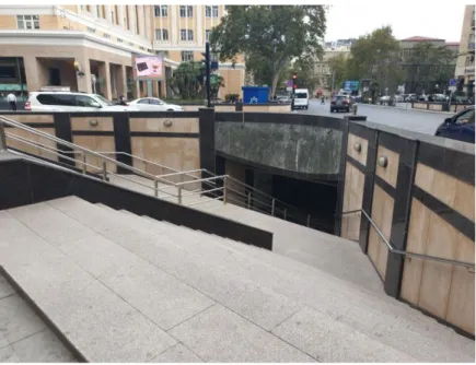
9 for the city. The public spaces in Baku are strongly divided between pedestrian zones and driveways, and pedestrians are usually split from the urban traffic. Such a design made private cars a dominant mode of transportation and its growing role negatively influences the urban environment of Baku. For instance, under such conditions, pedestrians are forced to use the underpasses and the overpasses for crossing the city roads. Excluding people from the road traffic this way can be understood as the desire of the city planners to ensure rapid movement of private vehicles with the aim to prevent traffic congestion. It is known that despite its dense main road network equaling around 1600 km, the investments made in such a design do not pay off and Baku remains a congested city (World Bank, 2018). Nowadays the State Road Agency (SRA) keeps constructing the grade-separated facilities. For instance, from the day I have started conducting this research (early February 2020), four overhead bridges were finished and put into operation by the SRA (Table 1). According to the press secretary of the State Road Agency of Azerbaijan Anar Najafov, there are 113 grade-separated facilities constructed in the city of Baku to the date: 41 overpasses and 72 underpasses (Varlamov, 2020a).
Table 1. The timeline of events related to the research topic happened in Baku. Source: created by author.
I worth mentioning, that the provision of pedestrian safety in urban areas of Baku by constructing grade-separated facilities like the overpasses and underpasses has faced quite a large amount of criticism among researchers, independent experts based in Baku and activists. For instance, according to the Global Designing Cities Initiative, elevated crossings increase the walking distances and time, take the valuable space that could be used for designing sidewalks and can cost 20 times more than the at-grade road crossing facilities (GDCI, 2007). Moreover, according to Varlamov (2020b), since the overhead pedestrian bridges are usually not used by the pedestrians due to the physical efforts and time required for their use, these facilities can rather lead to even more traffic accidents between pedestrians and cars. On the figures below it is possible to see the traffic accidents (Figure 2) in Moscow at the locations with grade-separated facilities (Figure 1). Based on the aforementioned, it becomes obvious that constructing overpasses within the urban environment is a poor way of providing pedestrians with accessible facilities for road crossing.
10
Figure 2. Grade-separated facilities in Moscow (violet lines) (Varlamov.ru, 2020b). Figure 3. Pedestrian fatalities between 2015 and 2020 at some locations in Moscow
(white circles) (Varlamov.ru, 2020b).
1.2 Rationale
The growing car-dependency in the cities located in the Global South, including the city of Baku, can be tackled by improving conditions for non-motorized transport like walking and cycling, as well as enhancing the role of public transportation for transit. The construction of the overhead pedestrian bridges in the urban areas can increase the role of private vehicles and can spoil the national and global efforts towards reducing the GHG emissions produced by the transportation sector. This objective can be reached by designing safe, accessible and inclusive urban environments, while improving mobility for all segments of people. The overhead pedestrian bridges that are designed in Baku for ensuring pedestrian safety, and are thought to reduce traffic congestion, raise a lot of questions regarding the both tasks. This study will examine these facilities in terms of pedestrian safety and accessibility and suggest the ways to improve the existing transport infrastructure in a way that could be beneficial for both pedestrians and drivers.
1.3 Motivation
The main motivation of this research is to shed light on the both positive and negative impacts of the overhead pedestrian bridges and to illustrate the ways to avoid constructing these expensive facilities.
This research started with my desire to conduct a research on my home city – the city of Baku. It was quite challenging to find a research problem matching my initial plan while being a student abroad, so I was checking social media for some inspiration and was also trying to find some differences between Stockholm and Baku that also helped to identify the problem that gained my interest. It is important to mention that considering the field of my studies and my deep interest in topics regarding urban environments, I have spent quite a long time contacting scholars that conduct research on Baku to identify the main issues that deserve attention. The growing number of grade-separated pedestrian facilities
11 in Baku as well as the problem of gradually increasing motorization in the city were voiced a lot of times by independent experts and Facebook bloggers in Azerbaijan, while nobody (based on my literature review) has conducted such a research that would discuss the both issues and the connection between them. I decided to travel to Baku for a fieldwork and to find out whether the citizens use the overhead pedestrian bridges, and what are the issues that they usually face while using these facilities.
Throughout my research in Baku, I have realized that the research topic chosen for my Master’s thesis is highly relevant considering the existing trend of ensuring pedestrian safety by constructing pedestrian overpasses and underpasses. By conducting this research, I want to reduce the existing research gap regarding the grade-separated pedestrian facilities built in the city of Baku. Also, there is an obvious knowledge gap regarding the issues in the city’s transportation planning, while the number of studies conducted in English language is even more limited. Since, the image of the city of Baku is usually promoted as a place attractive for tourism and entertainment, this research project is also thought to fill the gap of a critical viewpoint on the city itself with a focus on transportation and mobility.
1.4 Aim and research questions
Generally, it is known that the overhead pedestrian bridges are constructed as facilities that provide pedestrians with safe crossing over the busy and high-speed highways (Hasan & Napiah, 2017). From another perspective, it is understandable that having these facilities within the urban environment is associated with increasing car-dependency and separation of pedestrians zones from the roads. In such conditions, pedestrians that should be able to cross the urban roads at grade using safe and all-accessible pedestrian facilities are unable to do so due to the safety risks. With respect to the ideas mentioned earlier, the
aim of this research is to understand the role and the impacts of the overhead pedestrian
bridges on the urban realm and to suggest some solutions for designing both all-accessible and safe pedestrian facilities in the city of Baku. The aim of this research will be reached by interpreting the collected empirical data based on the contextual and theoretical frameworks chosen for this study. This research project will be conducted based on the following research questions:
1. What do the pedestrians in Baku think about the
constructed overhead pedestrian bridges and their
role as the road crossing facilities?
2. What kind of infrastructure can be designed in Baku
to both facilitate road crossing and meet pedestrians'
preferences?
The first question was formulated to explore to what extent do the pedestrians in Baku use the overhead pedestrian crossings and to learn about the preferences of the pedestrians in Baku regarding road crossing. The second research question was designed in order to allow me suggesting the possible solutions based on the preferences of the interviewed people, and the issues that they suggested to be addressed. Since, the construction of the
12 overpasses is seen as a response to the increasing demand for pedestrian safety amid rapidly growing motorization of Baku, answering these research questions requires a good understanding of the existing issues in the transportation sector. The issues will be discussed in the following chapters alongside discussing the ways the pedestrian infrastructure can be designed to be accessible and safe for all segments of people.
2. Literature review
The chosen literature for this paper helps to understand the impacts of the overhead pedestrian bridges on the urban realm. The topic and the research questions for this research were chosen based on my observations during a year and a half of living and studying in Stockholm. This city applies quite successful policies for designing pedestrian-friendly environments. The noticeable infrastructural differences between my home city Baku and Stockholm drove my desire to understand why the overhead bridges are used in one city and are not widely used in another. In order to avoid preconceptions before the interviews, this literature review was developed based on the empirical data retrieved from the interviews. This research examines the main difficulties of pedestrians when faced with the overhead pedestrian bridges in Baku. In other words, this paper tries to understand what are the key factors that influence the decisions of people to use these facilities or to find alternative routes for crossing the roads with already constructed overpasses. The concepts of pedestrian accessibility and pedestrian safety are key aspects that can help to explain the way people behave in different situations.
2.1 Pedestrian accessibility
One of the key concepts chosen for this research is the term of accessibility that was defined by Hansen (1959) as the potential of opportunities for interaction (Gutierrez & Garcia-Palomares, 2020). Also, the term ‘accessibility’ is defined as the ease of reaching places where people want to go (Cervero et al., 2017). The concept of accessibility is widely used in transport geography as a crucial characteristic for locations and as a measure that shows whether some locations are easy to access or not (Gutierrez & Garcia-Palomares, 2020). As a measure, accessibility is usually used to evaluate the potential of transport infrastructure to be accessed and deliver different actors of traffic from one point to another (ibid.). Also, this concept is seen from the perspective of proximity and facility to social interaction and can examine social, political and economic factors of access such as the extent to what all social groups can afford the access to transportation and other private and public services (ibid.). In the context of the overhead bridges, the concept of accessibility explains whether people from different social and mobility groups are able to access and use the built facilities. The level of accessibility can depend based on different variables including the conditions of the overhead bridge, the distance to it, the
13 physical and mental state of pedestrians that are crossing the road and time spent on the use of the facility (Obeng-Atuah, 2016).
The central term to the concept of accessibility is walking that is seen as the basic mode for mobility of people. Alongside being an environmentally friendly and non-polluting mode of traffic, walking is known for its proven benefits to human health (Sinclair & Zuidgeest, 2016). In transport geography the role of walking is associated with involvement of wider groups of people that increases the share of non-motorized mobility in the city and creates inclusive communities for all people (Fabian et al., 2010). Based on a number of studies it is known that the growth of welfare in the developing countries leads to a higher reliance on private vehicles, while reducing the role of walking in transportation. (Fabian et al., 2010; Takamine, 2004) It is known that some people can deliberately choose walking as the main mode of transportation due to the financial limitations or the inability to drive (Fabian et al., 2010). Considering such factors, it is important to provide pedestrians with an adequate and accessible pedestrian infrastructure that would allow to secure their interests as walkers. The poor provision of pedestrian infrastructure creates obstacles for safe walking and can lead to jaywalking, or the situations of walking on roads that increases the risks of road traffic accidents with pedestrians (Lasmini & Indriastuti, 2010). Since the concept of accessibility describes such a design that considers the maximum range of potential users, the conditions under which pedestrians are unable to reach their target destination on foot is associated with poor accessibility.
The concept of accessibility can explain and demonstrate the way the publically and privately owned spaces should be designed in order to be accessible for all people. While talking about accessibility for all, it would be good to mention the term disability that is central to the concept of accessibility. This term describes a situation when the people are physically or mentally unable to do the things that people are normally able to do (Oxford Dictionary, 2020). A person who experiences a disability is physically unable to access some places and locations that are considered as accessible by the people who do not have disabilities. The infrastructural constraints existing within the environment surrounding the people with disabilities can put such individuals under a risk of exclusion from the normal rhythm of life. Disability should not be confused with the term social exclusion. Social exclusion describes a situation when individuals are blocked from integration into the society where they live based on unequal access to opportunities and resources that are accessible to more privileged social groups (Hine, 2020). It worth mentioning that physical and mental disabilities can be also among the reasons of social exclusion. It worth mentioning that the concept of accessibility should not be seen only within the context of vulnerable groups; the ordinary groups of people can be also seen as “vulnerable” against the heavy road traffic. Despite the fact that the target group chosen for this research project is not seen as “vulnerable” in the traditional understanding of this term, this research accepts the position that considers both the pedestrians without disabilities and those who experience disabilities in relation to safety and accessibility. While the overhead pedestrian bridges usually lack facilities like escalators and elevators that ensure accessibility for vulnerable groups, they also provide relatively limited level of accessibility to the people who do not choose using them due to the physical efforts and the additional time required for using these facilities. The interviewees mentioned various reasons that make the overhead bridges less accessible to them compared to the
14 signalized zebra crossings. Almost all respondents expressed their desire to cross the roads in Baku at grade and do not spend additional physical efforts to use the overpasses and underpasses. Based on the existing empirical data, it is possible to conclude that the overhead pedestrian bridges can cause quite similar accessibility-based issues to both vulnerable and ordinary groups of people.
2.1.1 Social exclusion
The term ‘social exclusion’ is used in various disciplines and contexts but in transport geography it is referred to as transport disadvantage and poor access to transport and services (Hine, 2020). Based on the definition, social exclusion can be interpreted as an inadequate access to certain locations that creates social inequalities and marginalizes one group in comparison to another.
In order to understand the key issues related to social exclusion in the context of the overpasses, it worth mentioning some of the categories of exclusion in transport defined by Church et al. (2000), which are the following: physical exclusion, time-based exclusion, space exclusion and fear-based exclusion (Hine, 2020). Physical exclusion refers to the cases when the designed infrastructure inhibits accessibility for groups with reduced mobility like the elderly, disabled people, parents with children or people loaded with heavy items (ibid.). In the context of this research, physical exclusion is seen as the most relevant category due to the additional physical efforts that are a part of using the overpasses. Time-based exclusion stands for cases when people with some extra duties like caring or parenting are limited on time thus highly dependent on the design of surroundings (ibid.). Since using overhead bridges is time-consuming, people can experience time-based exclusion that makes them reluctant to use these facilities (ibid.). Fear-based exclusion refers to a case when vulnerable groups try to avoid going to some locations perceiving them as dangerous places. A number of studies state that the overhead pedestrian bridges are usually seem dangerous to women, especially in the evening time due to a potential of assaults from strangers and pick-pockets (ibid.). Based on a personal experience and some interviews, I can admit that a large number of pedestrian bridges lack security measures like the presence of security employees or CCTV that makes the fear quite a justified feeling in the evening time. Also, it worth mentioning reduced mobility groups that can avoid using overhead bridges based on a fear of getting physical injuries due to the absence of auxiliary equipment like escalators and elevators on the majority of overpasses. The last exclusion category related to this research is the space exclusion that describes the cases when vulnerable groups are discouraged from accessing some places due to the security and space management strategies applied by the authorities (ibid.). It is obvious that some locations that are designed without considering pedestrians in general will be even less accessible to vulnerable groups. The lack of adequate pedestrian infrastructure and a high reliance on private vehicles can result in space-based exclusion.
15
2.2 Pedestrian safety
The concept of pedestrian safety is another key aspect deserving attention. The overhead pedestrian bridges are being built to provide pedestrians with a safe route that allows them to cross the busy and high-speed highway roads without interaction with vehicles. Despite such a clear vision, it is highly important to rethink what pedestrian safety exactly stands for. For instance, according to Zegeer (2002), the overpasses are usually underused by the pedestrians who are usually ignoring such facilities if there is an opportunity to jaywalk. Also, the pedestrian bridges can become obstacles for the people with reduced mobility and lead to even higher safety concerns.
Nearly all people can be seen as pedestrians because walking as a mode of mobility is one of the most basic physical abilities which people are normally given by nature. Ensuring safe mobility for pedestrians through designing adequate pedestrian facilities is crucial for promoting walking as a mode of transportation. According to Cervero et al. (2017), creation of safe and active pedestrian environment is a cardinal feature of a vibrant, livable neighborhood. It is known that in order to provide pedestrian safety, it is important to create dedicated areas for pedestrians (where they will not be exposed to motorized traffic), reduce the speed limit and increase the awareness of both pedestrians and drivers in terms of what is called safe behavior on the roads (Obeng-Atuah, 2016; Amaoko et al., 2013; Damsere-Derry, 2010; Andrade et al., 2015; World Bank, 2018). While talking about pedestrian safety it would be good to mention that the overpasses are facilities that are originally planned and designed with the idea of providing pedestrian safety (Retting et al., 2003; Sangphong & Siridhara, 2014). The general logic behind construction of overpasses or, in other cases, the underpasses is that pedestrians will get such a facility that will separate them from the busy road traffic while reducing the risk of road traffic fatalities with pedestrians. According to some studies, the overhead bridges have immediate effects on pedestrian safety in some countries while even having a great potential to reduce budget spending on healthcare due to the reduction of traffic accidents between vehicles and pedestrians. One study emphasizes that despite the high prices, the overhead bridges can pay off the money spent on their construction in several years based on reduction of budget spending on healthcare (Mohapatra, 2014). Also, it worth mentioning that the overhead pedestrian bridges are seen as the only solution for provision of pedestrian safety on high-speed highway roads where these facilities give people an opportunity to cross the roads safely (Andrade et al., 2015).
Based on the perspectives mentioned above, it would be difficult to deny the benefits from the overhead pedestrian bridges but there is something that is widely neglected by some designers and the advocates of grade-separated facilities. The construction of overhead pedestrian bridges, that are widely used in developing countries like Azerbaijan, is seen as a solution that provides pedestrians with safe havens for road crossing but the idea behind safety in this context is highly idealized and is way far from reality. For instance, according to the press secretary of the Main Police Department of Baku City Vagif Asadov, the number of road traffic accidents between pedestrians and cars constitutes 59% of all road traffic accidents in the city of Baku since the beginning of the year 2020, while the majority of these accidents occurred in the areas with grade-separated facilities like the underpasses and the overpasses (Sputnik, 2020).
16 2.2.1 Pedestrian safety and pedestrian infrastructure
While talking about pedestrian infrastructure or pedestrian-friendly infrastructure, the main concern of this research remains suggestion of at-grade facilities that have a huge potential to replace the grade-separated facilities like the overpasses and underpasses. Such infrastructure includes a combination of zebra crossings, road signals, refuge islands, road medians, low curbs, ramps, cycling lanes, wide sidewalks and narrow roads with a low speed limit. According to a number of publications (Zegeer, 2002; World Bank, 2018; Obeng-Atuah et al., 2016; Fabian et al., 2010; Pasha et al., 2015), such infrastructure ensures safety and inclusiveness and creates significant economic opportunities, while remaining a cheaper and a more effective alternative to grade-separated facilities. According to Amaoko et al. (2014), pedestrian safety can never be ensured without an adequate provision and maintenance of pedestrian infrastructure. Regarding the context of Baku, World Bank report (2018) states that the city has to improve its pedestrian and cyclist friendly infrastructure to make the urban environment more inclusive towards all pedestrians including women, children and people with reduced mobility.
From another perspective, it is important to mention that car ownership and the ability of driving remain the two key factors that create the main inequalities in the city and create the demand for a more pedestrian and cyclist-oriented development of the cities. As it was stated by Toole and Zimny (1995): “the ability to walk or bicycle to a destination is critical to their [people who are either too old or too young to drive] freedom of mobility. Transportation planners and engineers therefore have the same level of responsibility to provide for the safety of bicyclists and pedestrians as they do for motorists.” The same applies to the case of Baku, where pedestrian facilities look more like an attachment to road infrastructure than a matter of high priority. As it was emphasized by some of my respondents, the overhead bridges built in urban areas in Baku serve for the interests of drivers, not pedestrians because they create better conditions for driving and exclude pedestrians from the streets.
2.2.2 Pedestrian safety and pedestrian behavior
The number of road traffic incidents with pedestrian injuries and fatalities is alarmingly high in a number of developing countries including Azerbaijan. According to World Bank (2018), despite serious improvements in transport infrastructure in recent years, road safety remains a serious problem in Baku with a fatality rate around 200 people annually that includes many pedestrians. In order to better understand the underlying reasons and invisible issues leading to road traffic accidents, it is highly important to understand the behavior of people. This part of the research focuses on pedestrian behavior and tries to uncover through some key theories and concepts the main patterns that form such a behavior.
While talking about pedestrian behavior, it would be good to mention that it is usually shaped by a myriad of reasons that usually include demographics, time, distance and physical and mental conditions of pedestrians. It is evident that the decisions taken by pedestrians are usually determined by various conscious or unconscious factors that can be influenced by previous behavior, habits, the amount of awareness of risks and the influence of social norms (Räsänen, 2007; Yaoshan Xu et al., 2013; Holland and Hill,
17 2007; Shaaban et al., 2018). The expected-utility theory is known for its ability to explain the main reasons that shape pedestrian behavior in different situations. According to Bridge (2020) the expected-utility theory suggests that in spatial terms people tend to choose options that will potentially reduce the efforts and distances to purchase or consume goods. In the context of this research, this theory can be understood from the position of pedestrian preferences whether to use the overhead bridges or find alternative routes that would allow them to save time and energy. Such a weighted and rational decision-making is quite similar to the adaptations of the so-called dual-process model in publications by Fiske (1993) and Epstude and Roese (2011) where the authors state that humans tend to choose the most effortless scenarios due to their natural predisposition to do so.
On a contrary, other researchers believe that despite a significant influence of cognitive processes to the pedestrian behavior, in some cases the decisions taken by pedestrians can become the results of habits, reflections on the previous behavior or the imitations of group behavior (Yaoshan Xu et al., 2013). For instance, it was suggested that the level of conformity to road traffic-rules can be improved by educating young generations and through increasing awareness among people (Zhou et al., 2009). Also, some researchers found that some patterns of route choosing as well as road crossing can be determined by unconscious decisions such as in the case of the so-called desire lines or desire paths that are sometimes referred to as ‘urban hacking strategies’ (Foster & Newell, 2019; Kohlstedt, 2016). Desire paths can be interpreted as results of an inherited and often unconscious predisposition of people towards finding roads or tracks that would allow them to save time and energy. Such behavior is seen as a response and sometimes resistance to an inadequate design of the urban infrastructure and the way the people claim their piece from the already planned urban space.
3. Theoretical framework
The previous chapter introduced the two key concepts for this research – pedestrian accessibility and pedestrian safety which are thought to provide the reader with a broad understanding of the raised issue through the key aspects embedded into the observed concepts. This part of the research introduces the theoretical framework that was chosen to arrange the whole study on the pillars of theoretical thought that is free from the influence of my vision. Based on the issues raised in the previous chapter, such as the lack of access to certain locations due to their exclusive design and the importance of rethinking pedestrian safety in the context of developing countries, it is crucial to take a look into philosophical perspectives of other researchers and theorists that cover the issues related to the topics discussed earlier.
18
3.1 Same old mistakes
The high-scale economic and technological growth observed in the world after the World War II alongside the emergence of welfare states led to an unprecedented motorization of large cities and a drastic shift towards private car ownership. The policy makers began to embrace the high-scale development of road transport infrastructure with the implementation of unprecedented zoning strategies that were thought to connect each family house or community with the major roads. Such planning practices led to decades of urban sprawl around large urban centres and created a situation of a high reliance on private vehicles for transportation (Knowles, 2020; McCann, 2020). It worth mentioning that such urban design approaches started emerging before the World War II, in 1920s when some architects and theorists of that time were creating the concepts of the cities of future, that were thought to meet the demands of the high-scale industrial growth. For instance, Le Corbusier’s ‘radiant city’ model was thought to increase the speed of movement through motorways and railways that would connect job sites with residential areas consisting of large dormitory housing, built to accommodate hundreds of families (Dodson & Gleeson, 2009). Such a modernist approach was based on segregated land use with a deliberate separation of streets or the so-called “traffic machines” from residential, industrial and rural areas (ibid.).
Despite the domination of private vehicles for transportation throughout the previous decades, today the global planning trends have shifted towards mixed-use land development that is seen as the way to connect communities to the basic services and employment opportunities within their neighborhoods and to provide each area with accessible and safe facilities allowing people of all social groups to be able to use public transportation (McCann, 2020; ITDP, 2017; Cervero et al., 2017). Unfortunately, despite the huge investments in transportation sector in the last two decades, the land use practices in Baku are quite far from the emerging global trends. The interests of pedestrians and cyclists are neglected by the city authorities which coupled with poor provision of safe and accessible infrastructure creates numerous obstacles for non-motorized mobility.
3.2 New Urbanism
The new urbanism movement emerged in the 1990s as a response to modernist strategies of land use and zoning. It is important to say that the first works suggesting a shift towards community building and designing pedestrian-friendly environments date early 1960s with the book of Jane Jacobs called ‘The Death and Life of Great American Cities’ where she suggested some approaches that eventually became basis ideas of new urbanism. The main suggestions of Jacobs were the following: a) a good neighborhood serve for more than one economic function; b) it must have mostly short block on the grid; c) buildings must be of various ages; d) it should be densely populated (McCann, 2020). The critics of new urbanism disagreed with some of the key ideas stating that the community which is seen as the basic unit for new urbanists can be oppressive and conservative and lead to violations of social norms in favor of conformity (ibid.). Other critics state that new urbanism as an approach is a product of western vision on the urban and regional development thus missing a deeper understanding of local knowledge that can be a victim of a “successful” strategy that worked somewhere in the west (ibid.). Despite existing criticism, the school of new urbanism offers quite fair solutions for correcting the
19 mistakes of the previous decades through a document called ‘Charter of the New Urbanism’ that consists of 27 parts covering 3 main levels for change: the region (metropolis, city and town), the neighborhood (also the district and the corridor) and the block, the street and the building. The first page of the Charter is devoted to the main approaches representing the school of new urbanism where the authors clearly state that they advocate:
“the restructuring of public policy and development practices to support the following principles: neighborhoods should be diverse in use and population; communities should be designed for the pedestrian and transit as well as the car; cities and towns should be shaped by physically defined and universally accessible public spaces and community institutions; urban places should be framed by architecture and landscape design that celebrate local history, climate, ecology, and building practice” (Charter of New Urbanism, 2000).
Since the overhead pedestrian bridges are grade-separated facilities that divide the pedestrian zones from the traffic roads, they do not fit the one of the basic requirements of new urbanism calling for neighborhoods diverse in use. As it was discussed earlier in this research, the construction of the overhead pedestrian bridges can be interpreted as the reaction of the urban planners in Baku towards growing motorization of the city. A high role of the private vehicles in the city’s existing transportation system creates a demand for separation of pedestrian infrastructure from the high-speed highways and city roads for ensuring pedestrian safety. As it was mentioned earlier, such a design is strongly associated with poor accessibility for pedestrians and cyclists and gives a higher priority to private vehicles in traffic. According to Cervero et al. (2017), shifting the priority from cars to public transport and non-motorized modes of transportation like walking and cycling can significantly increase gains for all social groups. The authors believe that such a change can reduce car dependency that becomes a highly-important objective in the situation of high-scale motorization in developing counties (ibid.). Transit-oriented development (TOD) is seen as a strategy that has a great potential for implementation of such reforms in both developed and developing countries (ibid.).
3.3 Transit-oriented development (TOD)
To continue this discussion, it would be good to talk about transit-oriented development – the strategy that acts as the one of the pillars of new urbanism and suggests practical solutions for improvement of urban spaces and making them pedestrian-friendly and accessible for all groups of people by reducing the role of private cars in the cities. Generally, the advocates of TOD suggest walking as the main mode of transportation, while introducing mixed-use development as the primary way to slow down urban sprawl that is seen incompatible for creation of densely-populated and compact communities (ITDP, 2017). The proponents of TOD offer shifting from car-oriented growth towards a smart development of transportation infrastructure that can reduce the amount of land required for highways and freeways through a higher reliance on public transport. In conditions of the looming climate change, the demand for different approaches that would allow to significantly reduce the carbon emissions from private cars and battle air pollution tends to rise (Cervero et al., 2017). It is known that the countries in the Global South seem the most vulnerable to environmental issues created by transport: more the nation becomes wealthier, more people have financial capabilities for buying private vehicles. Without an appropriate policy for diversifying the modes of transportation,
20 people in the emerging economies will tend to buy their own cars, which can lead to air pollution, problems with public health and increase the risks of safety.
In order to reduce such risks, the Institution for Transportation and Development Policy (ITDP) adopted standards of TOD in 2013 that included 8 suggestions for designing pedestrian-friendly and accessible communities with rapid and inclusive transit for all people (ibid.). The TOD standards introduced by the ITDP are the following:
- Walking: designing the urban areas in a way that allows people to access different activities on a walking distance in conditions of ensured pedestrian safety
- Cycling: creating such infrastructure that would turn cycling to a self-sufficient mode of transportation
- Connectivity: creating dense streets, making them appropriate for walking and cycling - Transit service: high quality public transportation system with stations located on a walking distance
- Mixed land uses: creating diverse areas that facilitate the access to various activities by reducing distances to them
- Density: housing and employment located on a walking distance to transit
- Compactness: tackling urban sprawl by concentrating development within the borders of the already used land
- Shifting: reducing the land devoted to driveways and parking
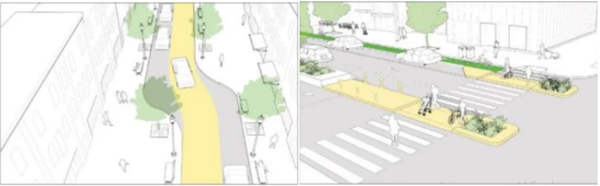
As it is seen from the standards, reducing reliance on private vehicles through improving conditions for walking and cycling as well as enhancing public transportation are among the central ideas. Based on the standards of TOD it becomes quite understandable that the current strategies used in Baku are far away from the global trends. The construction of the grade-separated facilities like the overhead pedestrian bridges are thought to ensure pedestrian safety and can be associated with rapidly growing motorization in the city of Baku. The existing trends in the transportation sector of Baku demonstrate that the traffic planners think to reduce traffic congestion and increase speeds of the traffic by widening the roads and adding extra lanes. Such road widening practices are usually conducted at the price of pedestrian sidewalks and the green lines. Generally, this strategy is seen ineffective based on the so-called ‘Braess’ paradox’ that states that adding more roads to the congested road networks can slow down the traffic flow (Bagloee et al., 2019) Also, as it is known from the so-called ‘Lewis-Mogridge position’, more roads are associated with more car traffic (Szymalski, 2016) According to this knowledge, it becomes evident that increasing the capacity of the road should be seen not through increasing the space for private vehicles but through diversifying the use of the road by different modes of transportation (Figure 5). Moreover, it is known that adding more lanes to the roads can lead to the so-called ‘bottleneck effect’ (Figure 4)– the term that stands for a situation when the car flow from a multilane freeway reaches a narrower city road, thus causing traffic jams (Yuan et al., 2014). It is understandable that it is impossible to make all the roads in the city of the same width, because it can lead to destruction of historically notable areas of the city. Unfortunately, such cases are quite well-known in the modern history of Baku. For instance, a neighborhood called Sovetsky was demolished in order
21 to construct a huge Central Park, surrounded by a multilane highway that connects the city centre with some densely populated areas on the other side of the city (Valiyev & Wallwork, 2019).
Figure 4. Bottleneck effect in road traffic (Brilliant.org, 2019).
Among the most successful examples of TOD, the case of Hammarby Sjöstad in Stockholm deserves a special attention. Once a brownfield area, the Sjöstad became one of the most successful urban regeneration projects for variety of components among which we can outline the tram line crossing the area through 3 accessible stations, separate lanes for private vehicles and bus transport, cycling lanes, wide sidewalks and a number of pedestrian zebra crossings through the roads that are helpful for traffic calming (Cervero et al., 2017). Other successful cases in Stockholm alone like Stockholm Royal Seaport project and Hagastaden with Torsplan, can show the role of good access to public transportation and of the mixed land use for economic growth. According to World Bank (2018), the redevelopment of once successfully used Baku suburban rail that involves all densely populated suburbs of the city across the Absheron Peninsula can create a good potential for TOD.
22 Figure 5. Passenger capacity of different transportation modes (corridor capacity)
(TUMI, 2019)
4. Methodology and research methods
This chapter will discuss the methodology and the research methods that were chosen for this research. Methodology is a set of methods and principles used to perform a certain activity, or in this case, to conduct a research (Oxford Learner’s Dictionaries, 2014). Some subchapters will be devoted to how the research methods and the research questions were developed for this study, and some other parts will discuss the role of the researcher in the research field and what are the main ethical considerations important for the research process. One separate section of this chapter will discuss the underpinning ontological and epistemological assumptions that shaped the research problem and helped to develop the main research questions for this study.23
Graph 1. The main steps of this research project. Source: created by author.
4.1 Research methods
Since this research was designed to understand the way people perceive the overhead pedestrian bridges and to find out whether they use them or not, I decided to apply qualitative research methods for my study. The qualitative method of research is based on open-ended or semi-structured interviews and gives the respondent enough time to answer the given questions based on a mutual sense of trust (Bryman, 2013). The strategy chosen for this research was more similar to the semi-structured interviews. The interviews consisted of the two main parts: the survey and the main interviews that were conducted both face-to-face or online. First it was planned to conduct all the interviews face-to-face, but the negative influence of the COVID-19 pandemic pushed me to reconsider my initial strategy and to prepare myself to online interviews both emotionally and technically.
The target group chosen for the interviews were non-married young individuals in the age range between 18 and 30 years old without any disabilities. This was done due to a number of factors. First, according to the read literature, young pedestrians and especially males, tend to violate the traffic rules more than other demographic groups (Zhou et al., 2009, Andrade et al., 2015). Second, due to the poor provision of pedestrian facilities in Baku, the people with disabilities are not able to move independently and generally tend not to go out. This target group is a subject to a separate research. Third, my choice was defined by the fact that Azerbaijan is the country with a predominantly young population
24 (State Statistical Committee, 2020, p. 20). Fourth, there is a research gap in understanding of how young people behave while facing the overhead pedestrian bridges (based on my literature review).
The research process was quite long (from February to mid-August) because of the pandemic but this also made me familiar with a number of young experts, researchers and bloggers from Baku who act as proponents of the principles of new urbanism and regularly break the voice with high quality content about the existing issues in the transportation sector and the way the land is used and managed.
4.1.1 Research design
The research design chosen for this research initially was based on open-ended qualitative interviews that were thought to provide me with the actual opinions of my respondents regarding the main questions that I had. It was planned that the beliefs and the actual quotes of people would prevail compared to the numbers of patterns that could be possibly found in the interviews. After a brief literature review, I have realized that in order to conduct such a research I had to focus on certain overhead pedestrian bridges and limit my work to a certain number of such objects. This was not matching my desire to understand what generally makes some people to use the overhead bridges and others to avoid using them. A research that would be tied to certain locations would show me only the local picture and would not allow me to examine the studied phenomenon through the lens of various cases. It was crucial to see a wider picture in order to avoid biased conclusions that could be challenged by perspectives of those people who, for instance, have to use the overhead bridges due to the factors that could be poorly voiced or given a lower consideration. Also, the reviewed literature demonstrated that the existing research on the overhead bridges is usually tied to quantitative methods or to a combination of qualitative and quantitative methods. This factor made me find a balanced solution through the semi-structured interviews that could provide me with some means of statistical data as well as with the actual quotes, beliefs and the patterns that could be found from the transcribed audio recordings. I decided to combine a short survey with open-ended interviews in order to provide my respondents with the possibility to explain their answers in the survey and to add more perspectives that could be valuable for finding patterns.
Given the quite short time for conducting a fieldwork for a Master’s thesis (around 6 weeks), and the financial limitations that I had for my trip to Baku, it was highly important for me to finish with the interviews by late March. Also, conducting a gender fair research was one of the most important objectives for me but I had faced some issues in setting up the exact dates and time for the interviews with females. This process was combined with a large number of changes in the schedule and switching to other potential respondents in case if the chosen person seemed reluctant to meet for an interview several times. Honestly, these changes were due to the fact that the majority of the chosen respondents were occupied and it was my duty as a researcher to be as flexible as I could. Also, such issues were strongly connected to the growing concerns regarding the COVID-19 pandemic in the society and the government of Azerbaijan initially decided to limit the working time of all cafes and coffee houses until 15:00 that was amid working time and
25 some people could not come to the interviews (Banker.az, 2020). I decided to find online recording programs and interview people online.
It would be good to mention, that the decision to interview people online was taken in mid-March when I also realized that I will have at least one more month in Baku due to the pandemic and the lockdown. It became easier to schedule interviews but the quality of the recordings was highly dependent on the quality of the internet connection on the both sides (me and the respondent). It worth mentioning that the originally chosen research design was quite successful because it would be impossible to meet random people near the overhead bridges and invite them for an interview amid the lockdown. The fact that I did not choose certain overhead bridges for my research, helped me to conduct my interviews mostly based on the previous experiences of my respondents. This method was quite adaptable with the snowball sampling that was originally chosen as the way to invite people for the interviews. As a result, since my research was not connected to some certain overhead bridges, I had managed to build a general picture about the use of these facilities in Baku and was able to adapt my work to the realities of the lockdown. Based on the aforementioned, it becomes obvious that the research design chosen for this research is normative in its nature. I was questioning my respondents about the present state of things with the aim to understand the studied phenomenon through analyzing their thoughts and to introduce a way for improvement based on policies implemented in other contexts (Stanford Encyclopedia of Philosophy, 2018; Wikipedia, 2009).
4.1.2 Face-to-face and online interviews
As it was mentioned earlier, the interviewing process consisted of the two main parts: the survey that consisted of 10 questions with 4 options to choose marked as ‘A’, ‘B’, ‘C’ and ‘D’ (Appendix I) and the open-ended interviews of twenty to forty minutes long. The survey that was written in two languages (Azerbaijani and Russian depending on the respondent’s language preferences) was sent to the respondents prior to the interview in order to make the respondent familiar with the topic of the research and to help me to build an overall picture of the respondent’s thoughts. Considering the fact that I am a bilingual Azerbaijani able to speak the both Azerbaijani and Russian languages, it was quite easy for me to discuss my research topic with the people that agreed to be my respondents. It worth mentioning, that it was highly important to find a unique approach to each individual as well as to ensure myself that I am not asking questions that reveal my personal opinion and beliefs to the respondents. The respondents were allowed to make multiple choices in the survey and were given the opportunity to interpret their choices in the main interview. Quite a wide range of issues and concepts were discussed with each respondent including accessibility of the pedestrian overhead bridges, pedestrian safety, the extent to what they consider Baku as a walkable city and what is their opinion about the existing transportation system.
Overall 30 interviews were conducted: 19 face-to-face interviews and 11 online through Facebook or Skype calls. Since, one of the most important objectives for me was to ensure gender equality, I have conducted 15 interviews with males and 15 with females. Since, it was quite tough to find female respondents, especially amid the COVID-19 outbreak, I decided to interview some of my female friends, while the absolute majority of female