Scientific Press International Limited
The Neo-Assyrians: Warriors and Canal Builders
under Sennacherib (911-609BC)
Nasrat Adamo11 and Nadhir Al-Ansari2
Abstract
The Assyrians established their empire in upper Mesopotamia after crushing Babylonia. In this narration, we describe among other things the achievements of their great kings in building new cities and constructing waterworks for water supply of these cities and for irrigating the lands in their surroundings. The introduction of Sargon II for the Kariz irrigation system, which he had used to supply his new capital Dur-Sharrukin, is detailed. This was followed by describing the great works of his son Sinnecharib, who after building his new capitol Nineveh brought water to it from the upstream reach of the Khosr river by excavating a large canal called Kisiri Canal and creating a reservoir. He even arranged to release the floodwater into a nearby depression, which he turned to a reserve for wild animals. Finding out that the canal discharge was not enough for all his cultivations and parks he tapped springs in the surrounding hills and mountains and collected their water in eighteen canals to supplement the reservoir. In this scheme he constructed also all the required engineering structure such as weirs and dams. However, his biggest achievement in this work was in drawing water from the Khazir- Gomel River from a point northeast of Nineveh and bringing it to the same reservoir by excavating a very large 50 kilometers canal. The canal is named as the Bavian canal in reference to the name of the location of its intake. Full description of the site, the diversion weir needed, and the intake structure are presented and illustrated by photographs and maps. One of the major structures of this canal, the Jarwan aqueduct, which was employed to pass the stream over a very wide wadi, is described in details as it gives insight of the ingenuity of the people of that time and shows how they had dealt
with such cases. Sinnecharib was also responsible for constructing more large hydraulic works; of
these the Kariz system of Bastoura- Erbil is fully described and his improvement on the water supply scheme of the city of Kalhu (Nimrud) and its irrigation project
1 Consultant Engineer, Norrköping, Sweden. 2 Lulea University of Technology, Lulea, Sweden.
Article Info: Received: February 10, 2020. Revised: February 15, 2020. Published online: March 30, 2020.
originally built by king Ashurnasirpal II (883- 859BC) are also presented. Moreover, a general idea is given in this paper on agriculture and the types of crops and vegetable and fruits grown to indicate the prosperity of this empire. However, as always in similar cases, this empire was distained to fall after internal conflicts over the throne and external attacks from outside envious enemies. Some authors even add another reason, which is the drought which had hit the heartland of Assyria in later stage. So the story of the Assyrian Empire ended in the year 612 BC when Nineveh fell to the combined forces of the Babylonians and Medes and the defeat of its last king Ashur-Uballit who was defeated in his last stronghold in Haran which took place taken in 610 BC.
Keywords: Assyrians, Warriors, Canal Builders, Sennacherib, Iraq
1. The Neo-Assyrians
As we follow the history of agriculture and irrigation in Mesopotamia, this history continues to unfold more of the intriguing past to us. In addition, it is clear that agriculture and irrigation development cannot be isolated from the social and political settings of the Peoples, who developed them. Therefore, we find ourselves when we come to study both irrigation and agriculture in past Assyria, obliged to describe even if briefly, the background of these active and energetic People, who made history for more than one thousand years in the ancient world.
The Assyrians were Semitic people who had inhabited the plains of upper Mesopotamia around the city of Mosul on the Tigris River. This was sometime between 4000 BC and 3000 BC, and they made the city “Ashur” as their capital at the end of the third millennia BC. It was named after their god “Ashur” and its remnants can still be seen now on the right bank of the Tigris River near Al-Shirqat. The earliest Assyrian kings were relatively minor rulers. After the founding of the
Akkadian Empire, which lasted from 2334 BC to 2154 BC, these kings were
subjugated to Sargon of Akkad, who united all the Akkadian and Sumerian peoples of Mesopotamia (including the Assyrians) under one rule.
In their long political and military struggle against other Peoples like the Akkadians,
Hittites and Hurrians, the Assyrians managed in the end to unite and establish the
“Ashur kingdom” until they were subjugated again but this time under the
Babylonian King Hammurabi in 1595 BC. Next to that, there followed another
period of their power rise from 1365 BC to 1074 BC that included the reigns of kings such as Ashur-uballit I, Tukulti-Ninurta I (1244–1208 BC), and
Tiglath-Pileser I (1114-1076 BC).
Ashur-uballit extended the Assyrian control over the rich farming lands of Nineveh
and Arbela to the north. Tiglath-Pileser controlled the lucrative caravan routes that crossed the Fertile Crescent from the Mediterranean to the Persian Gulf. Much campaigning by Tiglath-Pileser I and succeeding kings was directed against
Aramaean pastoralist groups in Syria, some of whom were moving against Assyrian
decline for the next 150 years. But following the conquests of Adad-Nerari II of
Babylon in 911 BC, Assyria emerged as the most powerful state in the known world
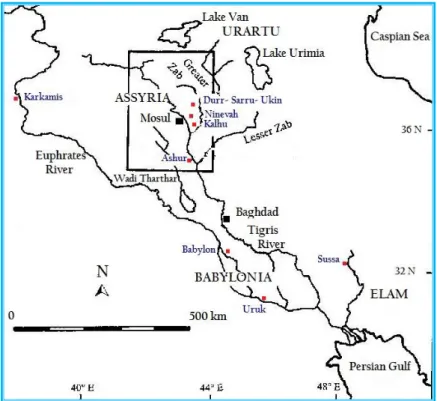
at that time, coming to dominate the ancient Near East, including the East Mediterranean, Asia Minor, Caucasus, and parts of the Arabian Peninsula and North Africa [1]. The map in Figure 25 indicates the extension of the Assyrian Empire
during the various periods of its expansion.
The Assyrians were warriors and fierce fighters but not much of farmers not like the people of lower Mesopotamians. Their land east of the Tigris River was undulating and hilly, which extended to the Zagros mountain foothills. Their agriculture was mainly growing rain-fed winter crops of wheat and barley helped by the good rainfall that characterized this region. Irrigation was limited to small plots of lands and orchards on the rivers’ banks or around springs and “Kariz” tunnel systems in the more hilly or mountainous locations. Their herds of sheep and goats had plenty of fodder at the lush planes and slopes of those hills. No elaborate irrigation systems, like those in lower Mesopotamia were needed, but the Assyrians needed to bring adequate quantities of water to irrigate those lands suited for permanent cultivation and to supply their many cities with water, and so they established themselves as great engineers and builders of canals, weirs, aqueducts and even tunnels.
Figure 25: The Assyrian Empire during various phases of its history [2].
During these years, the Assyrians continued to have the city “Ashur’ as their capital until it was moved by Ashurnasirpal II (Reigned 884-859 BC) to the city of Kalhu (Calah/Nimrud). It was moved again by King Sargon II (Reigned 722–705 B) to
Dur- Sharrukin (present-day Khorsabad) which was again moved to Nineveh by his
and the location of the four capitals.
Figure 26: Location of the capital towns of the Assyrian Empire (Ashur, Dur-Sharrukin, Neniva, and Nimrud). Present day towns are also shown [3].
The Assyrians were gifted inventors and energetic engineers. Some of their inventions stemmed from their militarism. For despite the harm it does in other directions, war certainly stimulates technology, which it did even at those times. Of these inventions, some examples can be cited. These are: equipping armies for the first time with iron weapons, developing the remarkable war chariot pulled by fast horses, introducing cavalry in their armies, using ladders fixed on heavy wooden frameworks and protected on the sides and top by boarding to shield their attacking soldiers from enemy arrows when scaling enemy fortresses walls, and even developing heavy battering rammers hanged on wheeled carriages to break enemy city gates.
In addition to developing engines of war and cavalry the Assyrian kings found time for peaceful public works. When Srgon II (722BC- 705BC) invaded Armenia in 714 BC he saw for the first time the irrigation systems not yet known in Mesopotamia, which is referred to in Persian as “Kariz” or “qanãt”. So Sargon made sure that such systems were constructed and used where they were needed in the empire, which they proved to be very practical and useful. A “qanãt” or “Kariz” is a sloping tunnel that draws water from an underground source in a range of hills down to dry plain at the foot of these hills. It has an advantage over open air
aqueducts in that less water is lost by evaporation or leakage on its way from these hills to the plains, in addition to exploiting ground water in a good and efficient way. To build a “qanãt”, a number of vertical shafts is dug along the course of the proposed conduit, and a continuous tunnel joins the bottoms of these shafts. At various points, other shafts are excavated at a slant from the surface to get access and maintain the tunnel. Finally, when the tunnel is completed and reached its destination, the flow of water is collected in a basin to be distributed to the distribution system of the irrigation channels Figure 27 [4]. Kariz system was,
however, only one way of the many other methods utilized in Assyria in their waterworks projects as will be seen later in this paper.
In Assyria, it was seldom that the Babylonian or Sumerian system of irrigation could be found applicable, where water was simply derived from the rivers by side-cuts, leading it off by gravity from the natural channels to the flat alluvial lands. There was but little of Assyria, which could be irrigated by this simple kind of application. In eastern Assyria, between the Tigris and the mountains the land was generally undulating, and much of it stood at a considerable height above the various streams. Water, therefore, was required to be raised from the level of the rivers to that of the land before it could be used, or otherwise, it was to be drawn from upstream locations to downstream areas to avoid lifting. The Assyrians endeavored to provide some sophisticated hydraulic arrangements to accomplish this. Apart from digging canals from far distances to get the required command, these canals had to cross natural wadis by aqueducts of one kind or another. Moreover, where conditions were favorable, the Assyrians also constructed long and elaborate tunnels for Kariz conduits systems. The Assyrians might occasionally, like some of their modern counterparts, have employed the labour of animals to raise limited quantities of water by driving waterwheels; but historical evidence indicates that such use was limited. Similarly, we do not trace the use of water-wheels on rivers like those employed on the Orontes (A’sse River in modern Syria) or on upper Euphrates in Anna and Allus in Iraq).
Figure 27: Details of a “Kariz” system [4].
Assyrian kings were challenged by the difficult nature of the territory to construct
elaborate schemes to bring water to their cities and to irrigate the land around them; therefore, it is not strange to see great water works built by them around those cities.
Ashur, the first capital of the Assyrian Empire, was located on the Tigris River as
this was shown in Figure 26. It did not need water supply from another source, but the capital was changed later on to “Kalhu (Nimrud)” by Ashurnasirpal II who reigned in (884–859 BC), then to ”Dur-Sharrukin” by Sargon II and finally to “Nineveh” by his son Sennacherib (705- 681BC)[5]. Sennacherib moved to Nineveh
and took it for home as soon as he rose to the throne.He himself was a dreamer who liked to model things to his liking and taste. His desire for greatness drove him to build the new capital with its magnificent architecture; and his love for lush fields and gardens incited him to look for enough water resources to irrigate them. To speak of the town planning, he surrounded the city with a huge wall faced with stone and pierced by fifteen gates, which embraced the two mounds on which the temple and palaces stood. The rest of the area was an irregular quadrangle about one mile from east to west and three miles from north to south, and it was occupied not only by dwellers of the common folk, but also by public parks and orchards of private citizens. In Figure 28 the map shows the Nineveh wall and its fifteen gates. On this map isalso shown the location of Nabi Yunis Mosque (destroyed in 2014 by ISIS) which was built on the site of the tomb of Prophet Jonah, who was sent by
God to prophesy the destruction of Nineveh and to warn the Ninevihans; according to the story of the Bible. Also seen from the map the Tebitue River (present day Al- Khosr River) which penetrates the city [6].
Figure 28: Map showing Nineveh great wall with its fifteen gates [6].
During the rule of Sinnecharib, Nineveh expanded in area from 150 ha to 750 ha which indicates the magnitude of development it attained during this period [7]. To
water all the fine plantings and orchards, Sennacherib undertook the construction of vast schemes of water works. He personally toured the countryside near Nineveh, striding over mountains, to choose the sites of his constructions. Ten miles north of
Nineveh near a village that was called Kisiri, near the present day’s village Qayin;
he dammed the river Tebitue (Al Khosr River) which flowed from the north and ran through the middle of Nineveh and emptied into the Tigris just to the west of the city. From the reservoir thus created he brought a canal down to the city. Since the grade of this Kisiri canal was less than that of Tebitue River, the canal water reached to the city at high enough elevation to be used for irrigation without hoisting. To take care of the flood overflow during the high water season in spring,
those of Babylonian cities, so water could be diverted to lower land, which turned into a shallow marsh. In the year 702BC, and again in 700BC, Sennacherib had visited the marshes of southern Babylonia in his pursuit of Assyrians’ enemies, and he was so impressed by their beauty and the scenery, which must have taken hold of him. He turned the marsh he had created into a game reserve, releasing deers, and attracting wild boar and game birds to bread there. In addition, he planted thickets of reeds and timber trees, and he introduced so many types of herbs and plants to grow [8]. Two years after Sennacherib accession to the throne, in 703BC,
he was able to speak of the first results:
“To make the orchards luxurious, from the border of the town of Kisiri, to
the plains of Nineveh, through mountain and low land, with iron pickaxes I cut and directed a canal. For a distance of (1 ½ bëru) I caused the flow there everlasting waters from the Tebitue). Inside those orchards, I made them run in irrigation ditches”.
Sennacherib first canal sufficed for many years. When the city expanded further,
the king himself went out to investigate new sources, and he succeeded in locating many springs and pools around mount Musri (Present day Jebel Bahshiqa). The springs were enlarged, and the pools turned into reservoirs from which one canal carried the water down to Tebitue. From archeological diggings, it seems that the canal went by the present day village Bahizani very close to Bahshiqa and emptied in the Khosr upstream of the marsh. More diggings revealed the remnants of two dams that crossed the Tebitue which were built of square stone blocks. The lower of these two dams must have marked the place where water was sluiced to the marsh. In this grand scheme, it seems from recovered inscriptions that there were about eighteen of such canals, which Sennacherib had excavated. However, in his wild ambitions, one of these canals turned to being the grandest of them all, which was the Bavian- Khosr canal.Sennacherib wentmore than thirty miles from Nineveh, to the water shed of Atrush or Gomel River, thence; a canal was dug over land to the head weir of the Tebitue to carry the new supply of water to Nineveh, marking, maybe, the first inter-basin water transfer project in history. Where the canal carried the water from the Gomel River, near Bavian, Sennacherib had to build an aqueduct to cross a large Wadi, near modernvillage Jarwan, which may be considered as real wonder at that time. The map in Figure 29 shows the layout and extent of this grand project.
In 1934, Thornkild Jacobson and Seton Lloyd of the University of Chicago Oriental Institute expedition in Iraq undertook the archeological excavations at the Bavian Canal course and head works. The site investigation of Jarwan aqueduct itself was completed one year before that by the same archeologists, and the results of their work were reported in their book “Sennacherib’s Aqueduct at Jarwan”[9], from
which most of the material here is drawn.
The site of head works of Bavian Canal was selected in a gorge through which the
Atrush River flowed and emerged out in a new name as the Gomel River before it
entered an open country near the present village called Khinis. This site location was an ideal place from engineering point of view to construct such a dam to create
a reservoir and to place the canal intake as can be seen from the photograph of Figure 30 and the map of Figure 31.
Figure 29: Map showing the layout of Sennacherib Nineveh water project [10] Note: This map is edited and all names are translated from the original
Arabic into English by the author.
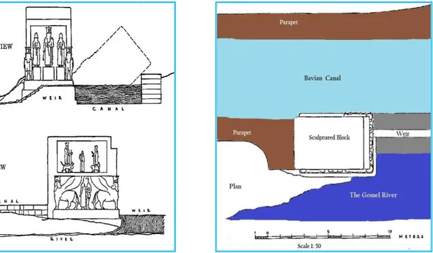
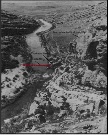
The photograph of Figure 30 shows the gorge at Bavian looking south, and showing the river course and the recent village of Khinis on the hill at the far right side of the picture. The dam axis is marked on the photograph with a red line, and the location of the intake of the canal is indicated. When Sennacherib finished construction, he placed a huge monument at the intake of the canal. Sennacherib made sure that the history and greatness of the project and his own were inscribed
and carved on it. But during the passage of thousands of years this monument tilted and fell into the river and so blocked the entrance to the canal. This monument can be seen in its tilted position on this photograph.
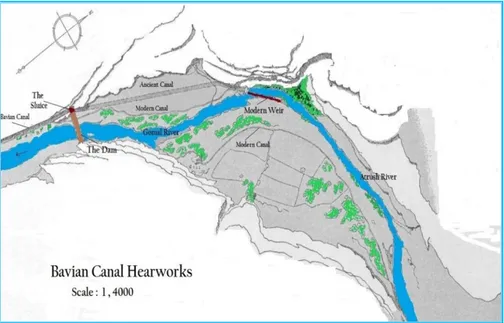
The location of the dam, the sluices and the head reach of the Bavian Canal are shown in Figure 31. This map shows also that the dam site is located downstream of a small modern weir supplying one recent irrigation canal. From the sluiced intake, the Bavian Canal ran along the side of the adjoining cliff, and had a width of six meters; its bottom was lined with cut stones and had a parapet at the riverside.
Figure 30: Location of the dam on the Gomel River showing the Mountain scarp overlooking the site on which inscriptions and sculptures were carved commemorating this work; the canal intake is also shown blocked by falling monument which stood at the entrance side[10]. (Modified and marked by
Figure 31: Map showing location of dam on the Gomel River and the intake of Bavian Canal10. (Modified by the Author).
As the canal ran a short distance in the downstream direction, it had to penetrate a spur of rock, which obstructed its alignment. This did not stop the engineers from excavating a tunnel through this spur to pass the canal through, which indicated they were technically prepared and equipped for performing such work.
The entrance to the tunnel and part of it was uncovered during the archeological works that were done in 1934, and Figure 32 shows this tunnel during excavation. The inside dimensions of the tunnel were (1 x 1.5 x 2) meters, and it was cut into the vertical face of the rock. It was not possible to dig the whole length of the tunnel by the expedition due to shortage of time, so its full length is not exactly known, but the trace of the canal itself could be found some distance downstream. The aerial photograph in Figure 33 taken in 1955 by another expedition indicates the locations of the weir and this tunnel. Speaking again of the entrance monument of the intake, Figure 34 shows some of its details, its location with respect to the weir, and the canal and even shows it in its tilted position.
As the canal emerged from the tunnel, it followed the topography of the ground in south easterly direction as was shown in the map in Figure 29, where its remnants can still be seen near many of the existing villages. One example is observed at 1500 meters east of the village called Shefsheren where the width of the canal appears to be 19 meters.
In its courese down to the Khosr river at a bout 30 miles distance, the canal crosses many Wadies on aquiducts which were built of limestone blocks, but the largest and greatest of them all was the one at the crossing of the main Wadi forming one of the
the name of this village in the writing of all the archiologists who investigated this project.
Figure 33: Aerial Photograph (spring 1955) of the Gomel Gorge near Khinis [11].
Figure 34: At the left, front and side views of the monument are shown. At the right, plan of the canal head headwork are shown with respect to the
Gomel River[10].
The aquiduct is formed of a large construction of solid stone massonary wall of twenty meters width and a height of nine meters at the wadi section which slopes upwards gradgualy to the west and even more gradually to the east. For stability the structure is supported by fifteen buttresses along its length on each side. Where it crosses the Wadi, it has five openings in the form of pointed arches to pass the flow of the wadi. The two end openings, however, have about one meter high cross walls in the form of sills closing the bottom part of the openings so as to concenterate the flow of the wadi through the middle three openings untill the flow overtop these sills, as shown in Figure 35, bottom left. As for the width of the aquiduct without the buttresses it is twenty meters, and its length from one end to the other is two hundreds and eighty meters, so one can realize what great volume of massonary which is involved.
If we assume the blocks of stones to average rather less than 50 centemetres cubed, the number of stones used would be well in excess of two millions. The masonary was built solid from the foundation up to the point little below the canal bottom level where a layer of concrete of 40 centemetrs thickness was laid to grade and the stone pavement was placed on it so that the grade of the canal bed was established at a slope of 1 : 80, and one parapet of one meter width was constructed along each side to contain the flow. Analysis of the concrete used was made at the British Building Reasearch Station which established that the matrix consisted from magiesium limestone aggregates mixed with lomy sand, which was cemented by
magnesian lime made by burning magnisum limeston and mixed with water. The ratio of aggregate to lime was estimated to be 4 : 1 by volume [10]. In laying the
foundations of the peirs, rectangular beds of rough boldures were laid a little beneth the stream level, large enough to accommodate the six peirs which were to support the arches. The boldures were surmounted by a level pavement copmosed of big stones laid diagonally to the direction of the flow of the Wadi in order to increase their stability in time of flood, and from this rose the peirs themselves. Simillar beds were evediently prepared for the foundations of the remaining structure Aassending the two sides of the wadi; the excavation was made in steps on which the foundartions were laid in simillar way as those of the peirs. At the top of Figure 35 an artist’s impresion of the aquiduct is shown. Photograph of the remains of one arch is also shown at the
bottom left of the figure, while the right bottom scketch details the remains of some of the archs.
One later study of the Sennicharib canal system was performed by the Department of Archieolgy at Harvard University, and its report was published in July 2005[11].
The study utilized two remote sensing data sources in following the course of the canal and some of its details.
Figure 35: Jarwan Aquiduct views;Top: Artist Impresion of the aquiduct; Bottom left: Remains of arched way looking upstream showning step at the end, Bottom right:Cross section and plan of arched ways ( scale 1:100) [10].
The first was a set of photographs of an air survey which was completed by the Iraqi Government in 1955; the second was a collection of photographs, which were declassified by the American Intelligence programs, and obtainable through US geological Survey website.The study showed in details the remnants of
and the location of Jarwan aqueduct. In addition to these achievements many other water projects were attributed to Sennicharib such as Maltai Canal, believed to have been supplied with water from Rubar Duhok River to the north from Nineveh, and similarly the Faida canal. Table (1) summariezs Sennicharibs canilization works related to Nineveh system giving lengths of canals, year of construction and average grade of the canals. The Musri System (Jebal Baqshiqa system) which we have mentioned in the context of the first extension of Tibitu (khosr) – kisiri extention is also given in this table [11] .
Table1: The Four Stages of Sinnecharib’s Canal System
Stage Year Length (Km) Gradient (m/Km) Km 1 Kisiri Canal 702BC 13.4 0.95 2 Musri System 694BC - - 3 Northern System Maltai Faida Bandawi Uskuf Tarbisu 690BC 46.4 Total 4.2 9.7 5.0 4.4 23.1 0.4 1.6 0.8- 1.0 1.2 0.6
4 Khinis (Bavian) 690- 688BC 55.0 0.90 Gomel-Gerwan)
In another part of Assyria, in the land lying between the lower course of the Great Zab River and the Tigris, the important town of Kalhu (now Nimrud) was located, as indicated on Figure 29. It was found by king Shalmaneser I (1263-1234 BC). However, the ancient city of Ashur remained the capital of Assyria, as it had been since about 3500 BC. The city of Kalhu (Nimrud) however gained fame when king
Ashurnasirpal II (883- 859BC) made it his capital at the expense of Ashur.
In the tract of land around the city the remains of a canal network undoubtedly,
Assyrian was found. This land was partly alluvial but more generally of secondary
formation of hard gravel, sandstone, or conglomerate. The exact date of the canal’s construction cannot be exactly ascertained, but in the most probable case could have been constructed by Shalmaneser I to bring water to the new city and to irrigate the land around it. One thing is certain with respect to this irrigation system, that is; it was renovated and maintained later on by King Sinnecharib.
The main canal was carried for a distance of more than twenty-five miles from a point on the Khazer- Gomal River, the tributary of the Greater Zab River, to the south-eastern corner of Kalhu (Nimrud). Originally, the canal seemed to have been derived from the Upper Zab itself, and water was drawn from the right bank of the river, through a short tunnel whose remains still exist in the place known by local
people as “Negoub”. It was then conducted along a cutting, first by the side of the Greater Zab, and afterwards in a tortuous course in the undulating plain, and across the ravine formed by the Shor-Derreh torrent (wadi). The Greater Zab when this part of the work was constructed, ran deep along its right bank and supplied water into the tunnel directly, which maintained a constant stream in the canal. But after a while the river abandoned its right bank for the opposite shore; and, water ceased to flow through the Negoub tunnel, so it became necessary to get the flow by some other mean.
Accordingly, the canal was extended northwards, partly by cutting and partly by tunneling, to the Khazer- Gomal River at about two miles above its confluence with the Greater Zab River, and a permanent supply was therefore secured from that stream. The work was intended in part to supply Kalhu (Nimrud) with mountain
water. From the remnants of dams and sluices along the course of the canal there is
sufficient evidence that it was intended mainly for irrigation. Water was probably derived from it to irrigate the whole triangle lying south of Nimrud between the two rivers, a tract containing nearly thirty square miles of territory, mostly very fertile, and with careful cultivation was well capable of supporting the metropolitan city on which it abutted as illustrated by Figure 36. An Assyrian inscription on a slab that was found by the British Archeologist Sir Austin Henry Layard (1867) in the tunnel, at “Negoub” gave sufficient evidence to prove that the tunnel, and the irrigation canal network seemed to have been improved and maintained by Sennacherib himself [12].
Figure 36: Sketch showing location of Kalhu “Nimrud” and ancient irrigation canals system (Modified from Layard (1867) [12].
One more important irrigation scheme that was constructed by the Assyrian kings was that which carried water to the ancient city Erbil (Araba-ilu) and to the plain around it. Human settlement at Erbil can be dated back to possibly 5000 BC, and it is considered as one of the oldest continuously inhabited cities in the world. Erbil became an integral part of the Assyrian Kingdom by at least the 21st century BC
through to the end of the 7th century BC. For this reason Erbil itself and the area around it are rich with the remnants of the works of the previous civilizations, and especially the Assyrian. These may be seen in the remnants of the irrigation projects which have marked features on the landscape of the region.
Not far from Erbil, one of the most important historical irrigation projects was discovered; the Bastora system attributed to Sinnecharib himself. The scheme utilized an excavated subterranean tunnel which formed a very long Kariz, and drew water supply from a place called Bastora to supply the Erbil area. This Kariz did not take its water exclusively from ground water as normal for such systems but directly from a river located to the northwest of Erbil called Bastora River (Chai), and could have been supplemented by ground water along its course The. Bastora
River originates from the Safin Mountain, Bani Bawa Dagh and Salah-i-Din area,
which was known to the Assyrians as “Khani Mountains”. It runs in westerly direction for about 50 kilometers and empties into the Greater Zab River at a point
located south of the village called “Sharafana”; upstream from the confluence of the Khazer- Gomel River with the Greater Zab. The river normally carries good supply of water and is considered even today as a good source for irrigation water supplies. The location of the Bastora Karez tunnel intake was located at about 1.1 km east of the village named “Qalat Mortik” and was at an elevation of about 50 meters above the land that the Karez was to irrigate. The intake site was visited by the late Fouad Saffar; a prominent and well-known Iraqi Archeologist in (1946-1947), who mapped and photographed the stones of the remnant part of the intake and documented the inscriptions he found on the stone masonry of this structure, which attested clearly that the project was attributed to King Sinnecharib. Safar articles on this discovery in the Iraqi journal of archeology “ Sumer” were the basic reference for further detailed work carried out later on by the archeology team from Harvard University in 2012 who published their report in (2017)(13). This team had worked
previously on Sinnecharib Bavian canal and the Nineveh system as explained already (see reference no. 11). According to Sousa (1986)[9] a masonry spur was
built in a skewed position against the direction of the flow in order to divert part of the river flow to the tunnel portal that was dug in the rocky escarpment at the left bank of the river. This masonry work which was 15 meters long was constructed from stones that were cut in blocks of 62 x 43 x 80 centimeters in dimensions. One of these stones had eight lines of inscriptions, which were documented and translated by Saffar, and it read the following:
“I, Sinnecharib, King of the World has dug three rivers in the Khani Mountains above the city of Erbil and added the waters of springs from the right and left sides and made the canal run to the middle of Erbil; the seat of the Great Lady God Ashtar, and made the course of it straight”. From this, we may
conclude that Sinnecharib had constructed many canals to collect water, and that this particular Kariz had tapped many underground springs at both of its sides to make it a very complicated and extensive system.
In the survey carried out by the Harvard University team [13], the shafts of Bastora canal proved to be elusive. Despite the known position of the canal head,
unambiguous shafts or upcast rings could not be identified in any remote sensing data sets available to the team, which otherwise displayed abundant karez traces elsewhere in the survey region. But ground inspection resulted in locating nine features, which could fall on the route of Bastora canal as reconstructed from the sketch map of Safar Figure 37. The same survey also revealed the presence of a very large open irrigation canal very much similar to the Nimrud (Kalhu) canal, which carried water from the upper Zab to irrigate large part of the Erbil plain thirty-kilometer west of Erbil itself, where over 65 km2 of land could be irrigated.
Figure 37: Map based on aerial photography showing the Bastora canal (Kariz) and other ancient irrigation features in Erbil plain [13].
In Assyria, a great deal of hard work was done to get irrigation water to cultivate the lands and grow their needs. Herodotus (484- 425BC) the Greek geographer and
Strabo (64BC- 21 AD), the Greek philosopher, wrote about this in addition to what
we have received from the Assyrians themselves in the form of inscriptions and monuments, confirm this fact.
In the geography of Assyria, there was but little flat alluvial lands. The land topography was generally undulating, and most of it stood at a considerable height above the water streams. Water, therefore, was required to be raised from the level of the rivers to that of the land before it can be spread over it. The Assyrians had either to go very far upstream of a river to tap water from it and bring it down in long canals making use of the difference in elevation and utilizing the sloping grade of the land, or in other cases, they used the Kariz subterranean conduit systems to bring water to these lands. They also sank wells were needed as their modern counterparts do today. Moreover, where they could make use of a suitable bank of convenient height over the river, they made use of the noria or other devices that
were used by the people in Sumeria and Babylonia. With these aids, they lifted the water into a tank or reservoir, whence they could distribute it to orchards or farms. In some instances, it was necessary to carry the water over wadis and natural water courses by means of aqueducts to bring it to where it was needed. For all these works, they must have had very good knowledge of hydraulics, surveying and constructing work experience.
In producing their food, the Assyrians, apart from animal husbandry, which was supported by grazing of their herds of sheep and goats at the foothills and mountains of eastern Assyria, they grew vegetables, fruit trees and grain. According to
Herodotus, the kinds of grain produced in Assyria in his time were wheat, barley,
sesame, and millet. These crops still constitute at the present day the principal agricultural products of the country, and we may conclude that they were in all probabilities the chief species cultivated throughout the Empire.
Besides grain, it seems certain that the Assyrians cultivated the vine. Vines grew well in many parts of Assyria; and the monuments left by the Assyrians represent vines with a great deal of truth, not merely as growing in the countries to which the
Assyrians made their expeditions, but as cultivated along the sides of the rivers
around Nineveh, and in the gardens belonging to the palaces of the kings. In the former case they appear to grow without any support, and are seen in orchards mixed with other fruit-trees, as pomegranates and figs. In the latter, they were trained upon tall trees resembling firs, round whose stems, they twine themselves, and from there their rich clusters droop as seen in Figure 38. Sometimes the long branches were brought to pass across from tree to tree, forming a canopy under which the Monarch and his consort sip their wine [14].
Figure 38: Assyrian representation of vine tree supported by another fruit tree, Rawlinson (1862) [14].
The Assyrian kings were fond of planting the courtyards of their palace gardens and public parks with trees and greeneries, and they brought back from conquered lands such varieties of these plants which were not known to them before. In her article “Ancient Mesopotamian Gardens and the Identification of the Hanging Gardens of Babylon Resolved”, Stephanie Dalley [15], gave an interesting account
of the Assyrian kings’ works in this field. One interesting passage which she quoted from an inscription on a discovered monument that belonged to Tiglath-Pileser, where he boasts in his royal inscriptions, says;
“I took cedar, box-tree, and Kanish oak from the lands over which I had gained dominion- such trees as none among previous kings, my forefathers, had never planted, and I planted [them] in the orchards of my land. I took rare orchard fruit, which is not found in my land and filled the orchards of Assyria”.
Just over a century later another Assyrian king, Ashurnasirpal II boasted of his works saying;
“I dug out a canal from the Upper Zab, cutting through a mountain peak, and
called it Abundance Canal. I watered the meadows of the Tigris and planted orchards with all kinds of fruit trees in the vicinity. I planted seeds and plants that I had found in the countries through which I had marched, and in the highlands which I had crossed: pines of different kinds, cypresses and junipers of different
kinds, almonds, dates, ebony, rosewood, olive, oak, tamarisk, walnut, terebinth [Pistacia] and ash, fir, pomegranate, pear, quince, fig, grapevine ... The canal-water gushes from above into the gardens; fragrance pervades the walkways; streams of water as numerous as the stars of heaven flow in the pleasure garden .... Like a squirrel I pick fruit in the garden of delights”.
When Sargon II (722-704 B.C) built an entirely new capital city, Dur-Sharrukin, north-east of Nineveh, he bought up land from local owners who were properly compensated, and had parks and orchards laid out for his royal pleasure, where he and his family could practice hunting lions, and falconry. But his keen interest in getting and planting all sorts of trees in Dur-Sharrukin, is shown in one letter sent to him by one of his governors which read as follows:
“I have levied upon the people of Nemad-Istar the supply of 2,350 loads of apple trees, and 450 loads of medlar trees. [The people of Suhu province] are collecting saplings of almond, quince and plum trees, and they are transporting them to Dur-Sharrukin. The people of Suhu are also bringing saplings from the land of Laqe: 1000 loads of apple trees. Their vanguard has arrived and I have seen it, but their rearguard has not yet arrived”.
Dalley tells us also that Sennacherib the King- Engineer had built a temple of the “New Year Festival” within a garden, outside the walls of the city Ashur. The temple of the “New Year Festival” may have been the place where the king, representing the god, performed the ritual marriage ceremony with a priestess. From the uncovered root-pits, the layout of trees or bushes was discovered by a German expedition, although the type of plants could not be established. Within the central courtyard as well as outside it on all four sides, trees or shrubs were planted very neatly in regular rows. The excavators reconstructed them as bushes, but they may have been trees with slim trunks, to give the impression of a sanctuary within a grove. This single example shows us that temple courtyards, like palace courtyards, were used for gardens.
The Assyrian Empire reached its zenith during the final decades of the 8th century BC and first decades of the 7th century BC. But as normal for most civilizations decline always comes afterwards leading to their dissolution and collapse. The reasons for such an end may vary, but they are always attributed to a combination of many factors. In the case of the Assyrian Empire the weakness of management of the widely spread empire during the rule of the last few kings following
Sinnecharib, in addition to revolts, insurrections, and political turmoil and
conflicts over the throne were good reasons for its fall. Moreover, severe climatic conditions leading to food insecurity and even famines exasperated in many cases the unrest.
Ashurbanipal (668- 627 BC) the grandson of Sinnecharib had initially peaceful
years of calm and bountiful harvests, which was ended by his brother
Samas-Summa-ukin revolt in (652BC). Decades of instability followed which may be direct
result of recurrent failures of harvest. In 657 BC an unusually severe drought impacted badly upon the Empire agricultural base. Given that the Empire was an agrarian society, and agriculture was the most basic element of the Assyrian
economy, this event proved to be detrimental. The Empire had already put much of
its resources into perpetuating and growing of this agrarian base and had even taken the pains of moving populations into the Assyrian Heartland from concurred lands to have the required manpower, but only to have this base weakened and undermined later on.
Schneider [16] advances two hypotheses for the dramatic fall of the Assyrian Empire.
First, he thinks that a major cause of this fall is rooted in the increased trend of aridity in the region, which contributed to the deterioration and undermining of the agricultural base of the Assyrian economy. Second; the explosion of the population which was brought about by the forced resettlement of people from conquered lands into the core area of the empire during the reign of Sinnecharib; who appears to have overseen the resettlement of more than half million people from outlying areas to the hinterland of Nineveh. This could have been due to political reasons or the need for cheap or even free man power to support his agricultural schemes, or may be both.The expansion of the new capital also placed additional stress upon food supply of the wider heartland region. Given the location of Nineveh is in the northern part of Mesopotamia, where mean annual precipitation was relatively plentiful, it is very possible that by expanding the city’s agricultural area,
Sinnecharib reduced the overall productivity of the Assyrian harvest by
concentrating manpower here , particularly during drier- than- average years. Moreover, because Nineveh was forced to obtain some of its food supply from other parts of the empire, this would have reduced the capacity of those other parts to draw upon surplus food stocks during periods of low agricultural productivity. Another author (Soltysiak)[17] seems to disagree completely with Schneider’s
hypotheses of climate change and overpopulation, and he argues that long- term climatic variation and the inter-annual variability in crops have always been very high in the dry farming areas of Upper Mesopotamia. To cope with this uncertainty, the local population developed several strategies (e.g. storage of agricultural surpluses in granaries and artificial irrigation in river valleys), and that the stable prices of slaves during this period suggest the absence of prolonged periods of food shortage. This researcher argues that based on texts belonging to Sargon II times suggest that the royal granaries, temple or municipal granaries were well prepared for potential drought outbreaks. Food storage was the primary insurance policy of the State.
Some other actions also decreased the risk of inter- annual weather variability. The
Assyrian armies confiscated the granaries of cities they defeated, and the irrigation
networks in the core provinces and along the Middle, and Lower Euphrates made the crops more predictable in these areas. Additional evidence of the relation between famine and slave prices indicates that three periods from 700 to 676 and 675 to 649 and 648 to 612 showed no significant difference in the average price of slaves, otherwise a drop of such prices would have been noticed as a result of the inability to feed those slaves[7].
Whether due to climate change and the occurrence of droughts or not, other factors also contributed heavily to the fall of the Assyrian Empire. Assyria’s outside
adversaries, who had their eyes on the thriving heartland of Assyria, and whom had suffered at the hands of the Assyrian armies; the Medes from the east and
Babylonians from the south, were growing in strength, and their constant
harassment to the Assyrians had worked negatively to the empire stability. The cessation of Egypt during Ashurbanipal rule dealt another blow and led to the rapid decline and demiseofthe empire. In 626 BC Babylon shook off the Assyrian yoke, defeating an Assyrian army. Two years afterwards, the Assyrians were defeated in battle with the Babylonians and their new allies the Egyptians only 300 km from Babylon itself, and in 616 BC the Medes under Cyaxares conquered also large parts of Ashur. In the year 612 BC, Nineveh fell to the combined forces of the
Babylonians and Medes. Haran, Ashur-uballit's last stronghold, was already taken
in 610 BC, ending the Assyrian Empire, Figure 39.
Figure 39: Map of the final stage of the Assyrian Empire.
To say some final words about the Assyrians; they, who had inherited the civilizations of Sumeria and Babylonia surpassed their predecessors in many respects. They introduced improvements, which gave greatly increased value and almost a new character to arts and technologies previously developed. The genius of these People is best being seen when full accounts are given of their language, their arts, and their system of government. In the words of Sir George Rawlinson, the renowned British Archeologist, he puts the Assyrians as superior to all their contemporaries and especially when compared with the Egyptians. It seems fitting; therefore, to close this paper by a quotation from his book “Five Great Monarchies of the Ancient “World” [14], in which he says:
“To appreciate the Assyrians; we should compare them with the much-lauded Egyptians, who in all important points are very decidedly their inferiors. The spirit and progressive character of their art offer the strongest contrast to the stiff, lifeless, and unchanging conventionalism of the dwellers on the Nile. Their language and alphabet are confessedly in advance of the Egyptian. Their religion is more earnest and less degraded. In courage and military genius, their superiority is very striking; for the Egyptians are essentially unwarlike people. The one point of advantage to which Egypt may fairly lay claim is the grandeur and durability of her architecture. The Assyrian palaces, magnificent as they undoubtedly were, must yield the palm to the vast structures of Egyptian Thebes. No nation, not even Rome, has equaled Egypt in the size and solemn grandeur of its buildings. But, except in this one respect, the great African kingdom must be regarded as inferior to her Asiatic rival, which was indeed "a cedar in Lebanon, exalted above all the trees of the field, fair in greatness and in the length of his branches, so that all the trees that were in the garden of God envied him, and not one was like unto him in his beauty.”
References
[1] Wikipedia, a (2018). Neo-Assyrian Empire. Accessed on 2018-03-20. https://en.wikipedia.org/wiki/Neo-Assyrian_Empire
[2] Eduljee, K. E. (2018). Assyrian Empire 1800- 627BC. Zoroastrian Heritage-
maps, Accessed on 2018- 03-20. https://www.heritageinstitute.com/zoroastrianism/maps/assyrianempire.htm
[3] Bragg, A. (2000). Irrigation in Northern Mesopotamia: Water for the Assyrian Capitals, (12th–7th centuries BC), Germany.
https://eurekamag.com/research/003/484/003484328.php
[4] Wikipedia, b (2018). Turpan water system description. Accessed on 2018-03-21
https://en.wikipedia.org/wiki/Turpan_water_system
[5] Knowledge Encyclopedia (2018). Sennacherib. Knowledge Encyclopedia from Wikipedia accessed on 2018-20-12
http://www.waterencyclopedia.com/knowledge/Sennacherib.html
[6] Wikimedia (2018). Nineveh City Wall and Gates. Accessed on 2018-03-21. https://upload.wikimedia.org/wikipedia/commons/5/58/Nineveh_map_city_w alls_%26_gates.JPG
[7] Wilkinson, T. J., Wilkinson, E. B., Ur, J. and Altaweel, M. (2005). Landscape and Settlement in the Neo-Assyrian Empire. P26 Bulletin of the American Schools of Oriental Research 340.
https://www.researchgate.net/publication/30052577_Landscape_and_Settlem ent_in_the_Neo-Assyrian_Empire
[8] De Camp, L.S. (1974). The Ancient Engineers. New York: Doubleday, 51-52. Available on line Internal Archives: https://archive.org/stream/ancientengineers00decarich#page/n3/mode/2up
[9] Jacobson, T. and Lloyd, S. (1955). Sennacherib’s Aqueduct at Jarwan. The University of Chicago Oriental Institute’s Publication Volume XXIV University of Chicago Press Chicago.
https://oi.uchicago.edu/sites/oi.uchicago.edu/files/uploads/shared/docs/oip24. pdf
[10] Sousa, A. (1986). History of Mesopotamian Civilization: in the light of irrigation of agricultural projects, recent archeological discoveries and historical sources. In Arabic, Vol. 1, Chapter 0, pp. 96-122. Published by the Iraqi Ministry of Irrigation, Al-Huriya printing house Baghdad 1986 Sosa https://ia601406.us.archive.org/21/items/nasrat_20190521_1844/%D8%AD %D8%B6%D8%A7%D8%B1%D8%A9%20%D9%88%D8%A7%D8%AF% D9%8A%20%D8%A7%D9%84%D8%B1%D8%A7%D9%81%D8%AF%D 9%8A%D9%86%20%D8%A7%D9%84%D9%81%D8%B5%D9%84%20% D8%A7%D9%84%D8%B9%D8%A7%D8%B4%D8%B1%20%D8%A7%D 9%84%D8%A7%D8%B4%D9%88%D8%B1%D9%8A%D9%88%D9%86.p df
[11] Ur, J. (a) (2005). Sennacherib’s Northern Assyrian Canals. Harvard University, Department of Archaeology.
http://www.people.fas.harvard.edu/~jasonur/pdf/Ur_Iraq67_2005.pdf [12] Layard, A. H. (1867). Nineveh and its Remains. John Murray London.
https://archive.org/details/ninevehanditsre03layagoog
[13] Ur, J., De Jong, L., Giraud, J., Osborn, J. and Magginnis, J. (2017). Ancient Cities and Landscapes in the Kurdistan Region of Iraq: The Erbil Plain: Archeological Survey 2012 season, September 22 2017. https://pdfs.semanticscholar.org/720b/4f7b6773ad5176fc802b6be667c6ca705 947.pdf’
[14] Rawlinson, G. (1862). Five Great Monarchies of the Ancient World. Vol.1 Oxford.
https://archive.org/stream/fivegreatmonarch01rawluoft#page/n5/mode/2up [15] Dalley, S. (1993). Ancient Mesopotamian Gardens and the Identification of
the Hanging Gardens of Babylon Resolved. Garden History, Vol. 21, No. 1,
pp. 1-13. Published by The Garden History Society. http://www.jstor.org/stable/1587050
[16] Schneider, A.W. and Adali, S. F. (2014). No harvest was reaped: demographic and climate factors in the decline of the Neo- Assyrian Empire.
file:///C:/Users/HP/Documents/Stephanie%20Dalley%20-%20Ancient%20Mesopotamian%20Gardens.pdf
[17] Soltysiak, A. (2016). Drought and the fall of Assyria: quite another story. Climate Change 136, May 2016.
https://www.researchgate.net/publication/302935412_Drought_and_the_fall_ of_Assyria_quite_another_story
![Figure 25: The Assyrian Empire during various phases of its history [2] .](https://thumb-eu.123doks.com/thumbv2/5dokorg/4426505.106486/3.813.199.579.501.805/figure-assyrian-empire-various-phases-history.webp)
![Figure 27: Details of a “Kariz” system [4].](https://thumb-eu.123doks.com/thumbv2/5dokorg/4426505.106486/6.813.64.739.109.519/figure-details-of-a-kariz-system.webp)
![Figure 28: Map showing Nineveh great wall with its fifteen gates [6].](https://thumb-eu.123doks.com/thumbv2/5dokorg/4426505.106486/7.813.222.594.193.668/figure-map-showing-nineveh-great-wall-gates.webp)
![Figure 29: Map showing the layout of Sennacherib Nineveh water project [10]](https://thumb-eu.123doks.com/thumbv2/5dokorg/4426505.106486/9.813.165.653.168.740/figure-map-showing-layout-sennacherib-nineveh-water-project.webp)
![Figure 32: Photograph showing the Excavation of Bavian tunnel [10].](https://thumb-eu.123doks.com/thumbv2/5dokorg/4426505.106486/12.813.225.536.170.508/figure-photograph-showing-excavation-bavian-tunnel.webp)
![Figure 33: Aerial Photograph (spring 1955) of the Gomel Gorge near Khinis [11].](https://thumb-eu.123doks.com/thumbv2/5dokorg/4426505.106486/13.813.111.683.118.587/figure-aerial-photograph-spring-gomel-gorge-near-khinis.webp)