Application of Hydrologic Metrics to Quantify Stream Health in
Small-Scale Urban Environments
Steven K. Roznowski1 and Larry A. Roesner2
Department of Civil and Environmental Engineering, Colorado State University
Abstract. Numerous studies have been conducted to assess the impacts of urbanization on stream geomorphology and ecology. Recent research has shown benthic macroinvertebrates to be good indicators of stream health. Furthermore, significant correlations have been shown to exist be-tween these benthic indicators and certain hydrologic metrics in receiving streams. These studies have used stream gage data and/or computer models to study such relationships but the scale of the watersheds has been large; typically greater than two square miles. This study examines the appli-cation of such research to a small-scale urban environment in Fort Collins, Colorado. The study uses benthic data collected approximately 10 years ago and stream flow measurements from the City’s flood early warning system. These data provide an opportunity to determine if the findings in other research can be applied to relatively small urban streams. Such trends could help guide development and stream rehabilitation efforts in the City to minimize future impacts of urbaniza-tion on these streams and provide guidance in prioritizing stream reaches for rehabilitaurbaniza-tion. How-ever, the use of such small scale real data in an ever-changing urban environment makes the appli-cation of hypothetical trends more difficult. Stream alteration, data limitations, and annual runoff variations present additional challenges for developing relationships between stream health and hy-drology that are seen to exist in larger watersheds.
1. Introduction
Historically, stream rehabilitation has focused on the physical aspects of streams how-ever this approach has been shown to be ineffective (Booth and Jackson, 1997). If in-stream rehabilitation is performed without making changes to contributing areas, the reha-bilitation will be unlikely to be a sustainable solution. Therefore, more recent research has focused primarily on the characteristics of watersheds which drain to receiving streams (Booth and Jackson, 1997; McMahon and Cuffney, 2000; Roesner et al., 2001; Konrad & Burges, 2001; Konrad and Booth, 2002; Roy et al., 2003; Booth et al., 2004, Nehrke & Roesner, 2004; Voelz et al., 2005; Edgerly, 2006; Sprague et al., 2006; Pomeroy, 2007; DeGasperi et al. 2009). To adequately rehabilitate streams, there must be a way of quanti-fying the effect that upland regions have on streams.
Stream health has historically been assessed based on chemical water quality parame-ters (Booth et al., 2004). New research however suggests that stream quality may be aptly determined by analyzing benthic macroinvertebrate communities (Roy et al., 2003; Booth et al., 2004; Voelz et al., 2005; Sprague et al., 2006; Pomeroy, 2007; DeGasperi et al., 2009). Therefore, any metric used to assess the impact of urbanization on stream health must be sensitive to benthic communities and measures of urban development. Such a
Application of Hydrologic Metrics to Quantify Stream Health in Small-Scale Urban Environments
Urbanization and resulting increases in uncontrolled impervious areas alters the natural flow regime by causing runoff volumes and rates to be increased (Booth & Jackson, 1997). Additionally, the frequency of high flow events will increase. The duration however, will decrease as runoff can travel more quickly in pipes and on impervious surfaces than via groundwater or as surface runoff from natural land (Booth & Jackson, 1997). Therefore an appropriate metric for the determination of the effects of urban development must ac-count for these changes in flow regime. One such metric is the T0.5. This metric, defined
as the percent of time which stream flow exceeds the half-year storm peak discharge, has been shown to correlate directly to urbanization and benthic macroinvertebrate health (Booth et al., 2004; Pomeroy, 2007). As urbanization increases, the T0.5 tends to decrease
due to the shorter travel time of runoff in urban settings. This lowering of the T0.5
corre-sponds to decreasing benthic health.
Mitigation of the hydrologic effects of urbanization may be done through the addition of best management practices (BMPs). BMPs are intended to reduce stormwater flows to match pre-development hydrology. It is hypothesized that the use of BMPs will positively affect stream health and increase the T0.5 as peak flows are attenuated.
This study applies prior knowledge of the correlation between the T0.5 and benthic
macroinvertebrate health to assess the suitability of streams for rehabilitation. The study, conducted in Fort Collins, CO, uses continuous stream gage records to calculate the T0.5
and compares these measurements to existing benthic data collected in the City.
2. Study Area
Fort Collins, CO is located in the Colorado Front Range along the eastern slope of the Rocky Mountains. Recent development and urban sprawl have caused rapid growth in the City whose population has increased from just under 119,000 in 2000 to over 136,000 in 2008 (U. S. Census Bureau). Starting in the middle to late 1800’s, irrigation canals were constructed to support agriculture in the region (Watrous, 1911, p. 71). These canals draw water from the Cache La Poudre River and flow from north to south through the City. Ad-ditionally, there are two major creeks that flow from west to east through Fort Collins. Spring Creek flows through the northern part of the City while Fossil Creek drains much of the southern part of the City. Boxelder Creek which enters the Cache La Poudre River from the north drains a relatively small area of Fort Collins. Gage data gathered from the City of Fort Collins’ Flood Warning System is used to assess in-stream hydrology at vari-ous places throughout the City. These gages provide roughly nine years of continuvari-ous flow records at four locations on Spring Creek, two on Fossil Creek, and one on Boxelder Creek. Figure 1 shows the location of these gages throughout Fort Collins. It should be noted that the gage located on Boxelder Creek is north of the City and is therefore not shown.
Figure 1: City of Fort Collins Streams, Canals, and Flow Gages (Source: City of Fort Collins)
3. Methods and Approach
The T0.5 metric was used as a tool to determine the suitability of streams for
rehabilita-tion. It was coupled with benthic data to determine possible correlations between urban development and stream health.
3.1. Calculation of T0.5 Metric
Values of the T0.5 metric were calculated for each of the stream gages in Fort Collins.
Gage data was generally available on an hourly basis. However, due to the climate in the Colorado Front Range, stream gages are removed each fall and redeployed each spring so as to prevent ice damage to the gages. Therefore, only summer data (May through Sep-tember) is consistently available.
To calculate the T0.5, the peak flow for the half-year storm (Q0.5) was determined using
a partial duration series (Langbein, 1949). Peak flows were ranked from highest to lowest and the Q0.5 was determined using the plotting position formula suggested by Cunnane
op-Application of Hydrologic Metrics to Quantify Stream Health in Small-Scale Urban Environments
Table 1: Stream Gage Q0.5 and T0.5
3.2. Existing Benthic Data
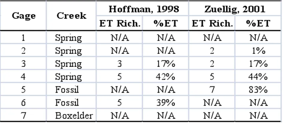
Two previous studies in the Fort Collins area have been performed on Spring and Fos-sil Creeks (Hoffman, 1998; Zuellig, 2001). These studies were used to calculate two common stream metrics based on Ephemeroptera, Plecoptera, and Trichoptera (EPT) taxa. These metrics, EPT richness and %EPT, are defined as the total number of different EPT taxa and the percentage of all benthic macroinvertebrates which fall into one of the EPT orders, respectively. Both studies indicated that Plecoptera have been extirpated from the Fort Collins streams and were ignored. Therefore, the resulting metrics were ET richness and %ET. Table 2 shows the benthic scores that correlate directly to stream gage loca-tions.
Table 2: Benthic Macroinvertebrate Data
4. Results of Analysis
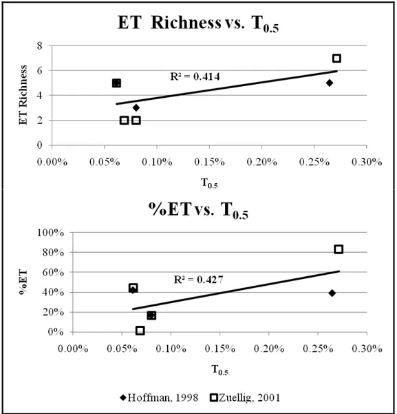
Compilation of the hydrologic data from Table 1 with the benthic data from Table 2, established a relationship between stream hydrology and benthic health. Figure 2 shows the relationship established between the benthic indices and the T0.5. This figure shows
that a general trend does exist as would have been expected based on the findings of previ-ous research (Booth et al., 2004; Pomeroy, 2007).
Figure 2: ET Richness and %ET versus T0.5
5. Discussion of Results
One of the key observations from Figure 2 is that the two points with the highest T0.5
values are both on Fossil Creek. These same points also have relatively high benthic scores. Points located on Spring Creek however tend to have low values of T0.5 and low
benthic scores. This disparity may be due to the difference in when these areas were de-veloped. The City of Fort Collins developed first in the northern part of town in and around Spring Creek. Only recently has development spread to the Fossil Creek Water-shed. Differences in the time of urbanization are relevant due to the advent of BMPs.
Application of Hydrologic Metrics to Quantify Stream Health in Small-Scale Urban Environments
Additionally, the development along Spring Creek is denser than that near Fossil Creek. Much of the Fossil Creek Watershed remains undeveloped and therefore should show fewer adverse effects from urban development. This may be further evidenced by the T0.5 calculated on Boxelder Creek. The Boxelder Creek gauging station is north of the
developed portion of Fort Collins. The area draining to this region is generally undevel-oped and is fed primarily by agricultural lands. This relatively undevelundevel-oped condition has caused a particularly high value of the T0.5 as shown above in Table 1. Though no benthic
data exists for this point, the value of T0.5 would suggest that high benthic scores could be
expected.
At this time however, there is not an appropriate method to quantify a specific value of T0.5 that is necessary to have good water quality. Sprague et al. (2006) found that for 28
sites in the Colorado Front Range that 75% of sites had EPT richness values of less than 10 with a maximum of 16. This suggests that values from the Fort Collins study may be typi-cal of those in this area of the country. Further research must be conducted to determine an appropriate value of EPT (or ET) richness that is indicative of good stream health in the Front Range area. This would better guide decisions on the prioritization of stream reme-diation.
6. Conclusions
The positive correlation seen in other research between the T0.5 and benthic stream
health (Booth et al., 2004; Pomeroy, 2007) has been shown to exist in the Fort Collins ur-ban setting. Through the use of existing data, the City may better direct its efforts in stream rehabilitation to areas with better hydrology. By more appropriately directing reha-bilitation efforts, the City can allocate its funds to those places where improvements will be most sustainable. Boxelder and Fossil Creeks show the highest values of T0.5 and are
therefore presumed to have high benthic health. These areas may be prime candidates for stream rehabilitation. Conversely, Spring Creek consistently produces low values of the T0.5. Such low values are indicative of the pervasive uncontrolled urbanization present in
the area. Without adding significant stormwater controls in the regions, rehabilitation ef-forts will most likely be ineffective. It is the author’s opinion that rehabilitation efef-forts would be best directed to those regions where acceptable hydrology presently exists.
Acknowledgements. The authors would like to acknowledge the City of Fort Collins for
providing intellectual and financial support for this research.
References
Booth, D. B., and C. R. Jackson, 1997: Urbanization of Aquatic Systems: Degradation Thresholds, Stormwa-ter Detection, and the Limits of Mitigation. Journal of the American WaStormwa-ter Resources Association, 33, 1077-1090.
Booth, D. B., J. R. Karr, S. Schauman, C. P. Konrad, S. A. Morley, M. G. Larson, and S. J. Burges, 2004: Reviving Urban Streams: Land Use, Hydrology, Biology, and Human Behavior. Journal of the
Ameri-can Water Resources Association, 40, 1351-1364.
City of Fort Collins. “Stream Map” [map]. City of Fort Collins GIS Data [computer files]. Fort Collins, CO: City of Fort Collins 2009. Using ArcMap [GIS Software]. Version 9.2. Redlands, CA: Environ-mental Systems Research Institute, Inc., 1999-2006.
DeGasperi, C. L., H. B. Berge, K. R. Whiting, J. J. Burkey, J. L. Cassin, and R. R. Fuerstenberg, 2009: Link-ing Hydrologic Alteration to Biological Impairment in UrbanizLink-ing Streams of the Puget Lowland, Wash-ington, USA. Journal of the American Water Resources Association, 45, 512-533.
Edgerly, J. L., 2006: Quantifying Urban-Induced Flow Regime Alteration Using Mathematical Models and Hydrologic Metrics (Master’s thesis, Colorado State University, 2006).
Hoffman, S., 1998: A Comparison of Two Macroinvertebrate Bioassessment Protocols in Fort Collins, Colo-rado Urban Drainages (Master’s thesis, ColoColo-rado State University, 1998).
Konrad, C. P., and D. B. Booth. United States Geological Survey, 2002: Hydrologic Trends Associated with
Urban Development for Selected Streams in the Puget Sound Basin, Western Washington (Water
Re-sources Investigations Report 02-4040).
Konrad, C. P., and S. J. Burges, 2001: Hydrologic Mitigation Using On-Site Residential Storm-Water Dten-tion. Journal of Water Resources Planning and Management, 127, 99-107.
Langbein, W. B., 1949: Annual Floods and the Partial-Duration Flood Series. Transactions, American
Geo-physical Union, 30, 879-881.
McMahon, G., and T. F. Cuffney, 2000: Quantifying Urban Intensity in Drainage Basins for Assessing Stream Ecological Conditions. Journal of the American Water Resources Association, 36, 1247-1261. Nehrke, S. M., and L. A. Roesner, 2004: Effects of Design Practice for Flood Control and Best Management
Practices on the Flow-Frequency Curve. Journal of Water Resources Planning and Management, 130, 131-139.
Poff, N. L., J. D. Allan, M. B. Bain, J. R. Karr, K. L. Prestegaard, B. D. Richter, R. E. Sparks, and J. C. Stromberg, 1997: The Natural Flow Regime: A Paradigm for River Conservation and Restoration.
Bio-science, 47, 769-784.
Pomeroy, C. A., 2007: Evaluating the Impacts of Urbanization and Stormwater Management Practices on Stream Response (Doctoral dissertation, Colorado State University, 2007).
Roesner, L. A., B. P. Bledsoe, and R. W. Brashear, 2001: Are Best-Management-Practice Criteria Really En-vironmentally Friendly?. Journal of Water Resources Planning and Management, 127, 150-154. Roy, A. H., A. D. Rosemond, M. J. Paul, D. S. Leigh, and J. B. Wallace, 2003: Stream Macroinvertebrate
Response to Catchment Urbanisation (Georgia, U.S.A.). Freshwater Biology, 48, 329-346.
Sprague, L. A., R. E. Zuellig, and J. A. Dupree. United States Department of the Interior, 2006: Effects of
Urbanization on Stream Ecosystems in the South Platte River Basin, Colorado and Wyoming (Scientific
Investigations Report 2006-5101-A).
U.S. Census Bureau. Population Finder. Retrieved February 16, 2010, from U.S. Census Bureau Web Site: http://factfinder.census.gov/
Voelz, N. J., R. E. Zuellig, S. Shieh, and J. V. Ward, 2005: The Effects of Urban Areas on Benthic Macroin-vertebrates in Two Colorado Plains Rivers. Environmental Monitoring and Assessment, 101, 175-202. Watrous, A., 1911: History of Larimer County, Colorado. Fort Collins, CO: The Courier Printing &
Publish-ing Company, 513.
Zuellig, R. E., 2001: Macroinvertebrate and Fish Communities Along the Front Range of Colorado and Their Relationship to Habitat in the Urban Environment (Master’s thesis, Colorado State University, 2001).