http://dx.doi.org/10.4236/jwarp.2014.612102
Present Conditions and Future Challenges of
Water Resources Problems in Iraq
Nadhir Al-Ansari, Ammar A. Ali, Sven Knutsson
Department of Civil, Environmental and Natural Resources Engineering, Lulea University of Technology, Lulea, Sweden
Email: nadhir.alansari@ltu.se, ammar.ali@ltu.se, sven.kuntsson@ltu.se Received 18 July 2014; revised 12 August 2014; accepted 1 September 2014 Copyright © 2014 by authors and Scientific Research Publishing Inc.
This work is licensed under the Creative Commons Attribution International License (CC BY). http://creativecommons.org/licenses/by/4.0/
Abstract
Iraq is part of the Middle East and North Africa (MENA region). It greatly relies in its water re-sources on the Tigris and Euphrates Rivers. Iraq was considered rich in its water rere-sources till 1970s. After that problems due to water scarcity aroused. Recently, it is expected that water shortage problems will be more serious. The supply and demand are predicted to be 43 and 66.8 Billion Cubic Meters (BCM) respectively in 2015, while in 2025 it will be 17.61 and 77BCM respec-tively. In addition, future prediction suggests that Tigris and Euphrates Rivers will be completely dry in 2040. To overcome this problem, prudent water management plan is to be adopted. It should include Strategic Water Management Vision, development of irrigation techniques, reduc-tion of water losses, use of non-convenreduc-tional water resources and research and development planning.
Keywords
Iraq, Tigris River, Euphrates River, Water Scarcity, Water Resources Management
1. Introduction
Iraq is part of the Middle East and North Africa (MENA region). It covers an area of 433,970 square kilometers populated by about 32 million inhabitants (Figure 1) [1] [2]. This region is characterized by its water shortage problem [1]-[6] where at least 12 countries have acute water scarcity problems with less than 500 m3 of renewable water resources per capita available [7] [8]. The supply of fresh water is essential to life, socioeconomic devel-opment, and political stability in this region. It was reported that one cubic meter of water can provide drinking water for one person for one year and the same quantity can produce only one kg of food grain when used for ir-rigation in a dry climate [9]. The largest consumer of water across the region is agriculture where it accounts for 66% of demand [5] [10] and therefore the water shortage problem cannot be objectively analysed nor adequately
Figure 1. Physiography of Iraq.
addressed without a thorough consideration of agriculture [11]. If we consider 10% transfer of water away from agriculture would produce a 40% increase in domestic water supply for Jordan [11]. Postel [12] argues that rather than diverting precious water to agriculture this water could be saved by importing the food/grain. However, this is not the case in many Middle Eastern countries which have unrealistic aspirations of food self-sufficiency and in it would require a most fundamental change in national outlook [13]. Sadik and Barghouti [11] emphasized that the extent of the problem is so severe that “the future challenges in meeting the growing demands for water are beyond the capabilities of individual countries”. Mitigating supply shortfalls could be achieved by re-allocation of current agricultural supplies [3]. Future predictions suggest more shortages [14]-[16] and depletion of groundwater re-sources [2] [17] [18].
Iraq is bordered by Turkey from the north, 352 km, Iran from the east, 1458 km, Syria and Syria from the west, 605 km and 181 km, respectively and Saudi Arabia and Kuwait from the south, 814 km and 240 km respectively (Figure 1). Topographically, Iraq is divided into 4 regions (Figure 1). The mountain region occupies 5% of the total area of Iraq, restricted at the north and north eastern part of the country. This region is part of Taurus-Zagrus mountain range. Plateau and Hills Regions is the second region and it represents 15% of the total area of Iraq. This region is bordered by the mountainous region at the north and the Mesopotamian plain from the south. The Me-sopotamian plain is the third region and it is restricted between the main two Rivers, Tigris and Euphrates. It occupies 20% of the total area of Iraq. This plain extends from north at Samara, on the Tigris, to Hit, on the Euphrates, toward the Gulf in the south. The remainder area of Iraq which forms 60% of the total area is referred to as the Jazera and Western Plateau.
Iraq was considered rich in its water resources compared with other countries where the annual allocation per capita reached 6029 m3 in 1995 and expected to be 2100 m3 in 2015 [19]. Construction of dams on the Tigris and Euphrates and their tributaries outside the border of Iraq, the effect of global climate change and mismanagement
of water resources are the main factors in the water shortage problems in Iraq [1]. Restoring the marshes [20] [21] and the growing demand for water in Turkey and Syria will lead to dry the Tigris and Euphrates Rivers in 2040 [20]. Furthermore, the supply will be 43 and 17.61 BCM in 2015 and 2025 respectively while current demand is estimated between 66.8 to 77 BCM. These suggest that the Iraqi government need to take quick, prudent and firm action as a high priority. One of the solutions is the use of Water Harvesting techniques [1]. To overcome these problems in Iraq, there is a great need for prudent management of water resources and the adaptation of non- conventional techniques to augment water resources [1] [22].
In this research, the present conditions and future expectations are described to give ways and means to over-come the scarcity of water resources problems in Iraq.
2. Climate
The climate is mainly of continental, subtropical semi-arid type. The mountain region is of Mediterranean climate. In general, rainfall occurs from December to February or November to April in the mountain region. During winter the average daily temperature is about 16˚C dropping at night to 2˚C with possibility of frost. In summer however, it is very hot with an average temperature of over 45˚C during July and August dropping to 25˚C at night (Figure 2).
The annual rainfall in Iraq varies where it reaches 150 mm within the western desert, more than 1000 mm within the mountains at the north to about 200 mm at the eastern part of the country (Figure 3). The overall av-erage annual rainfall is of the order of 213 mm per year. The rainy season begins in October and ends in April. It is evident from Figure 3 that annual rainfall increase from southwest towards northeast due to topographic effect.
Furthermore, it can be noticed that individual topographic regions are characterized by their own climatic factors and rainfall values. It should be mentioned however, that despite the local climatic differences, all the regions have similar overall climatic features. This is due to the fact that Iraq as a whole is affected by its geographic position. When rainfall is used as a base to classify the climate, two seasons can be noticed:
a) Dry season starting in April to September. b) Wet season starting in October to May.
It can be stated that October represent the transition period from dry to wet seasons while May representing the transition from humid to dry season.
The range of daily temperature varies greatly between day and night reflecting the continental climate. In ad-dition, the trend in temperature increase is exactly the opposite to that of the rainfall’s trend, where it increases from northeast toward southwest. The maximum daily temperature during dry season could rise to over 50˚C, while the minimum temperature during the wet season could reach −14˚C in Rutba and about −8˚C in Baghdad (Figure 2). It can also be noticed at the south, in Basrah in particular, that the temperature during summer is less than that of the surrounding areas due to high humidity resulting from being near to the Gulf.
Sunshine records indicate that during dry period, May-September, the average is more than 500 cal/cm2/day while it is below this value during wet season (October-April). Meteorological record was used to calculate the
Figure 3. Rainfall map of Iraq [2].
evaporation and evapotranspiration values using penman method. The results show that the overall average evaporation and evapotranspiration is of the order of 1900 mm per year. Furthermore, the values show an in-creasing trend similar to that of the temperature inin-creasing from northeast towards the southwest.
3. Water Resources
3.1. Surface Water
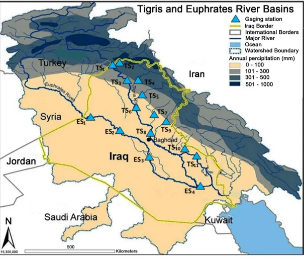
The rivers Tigris and Euphrates with their tributaries form the main surface resources in Iraq. Details of these basins can be found in Al-Ansari [1] (2013), Al-Ansari and Knutsson [22] and ESCWA [2]. The catchments area of these rivers is shared by five countries: Iraq, Turkey, Iran, Syria and Saudi Arabia, Table 1 and Figure 4.
Several ancient civilizations in the Mesopotamia were supported by basin irrigation from the Tigris and Euphrates Rivers since 5000 BC during Sumerian time. The ancient irrigation system was so efficient where it support wide spread cultivation of the land for many years without serious decline in land quality. Due to these marvelous water activities the term “hydraulic civilization” was used to describe this society.
Generally, the total annual flow of the Tigris and Euphrates Rivers is of the order 80 × 109 m3.This figure greatly fluctuates from year to year (Figure 5). Furthermore, floods and drought are themselves of variable magnitude. Such variations are due to changing metrological conditions. The period extending from October to February is referred to as variable flood period where discharges in both rivers fluctuate depending on intensity and duration of rainfall at their basins. This period is usually followed by what is known as steady flood period extending from March to April.
Flow records show that minimum and maximum annual flow of the Tigris was 19 × 109 m3 in 1930 and 106 × 109 m3 in 1969, while for the Euphrates it was 9 × 10⁹ m3 in 1974 and 63 × 109 m3 in 1969, respectively. Table 2
and Table 3 summarize the source and uses of water in both rivers.
3.1.1. River Euphrates
River Euphrates rises in the mountains of southern Turkey. It runs about 1178 km in Turkey before interring the Syrian territory where it runs 604 km to reach the Iraqi border. Inside Iraq the length of river is 1160 km. the total length of the river from Turkey to its confluence with the River Tigris south of Iraq is 2940 km, the total drainage
Figure 4. Catchments area of Rivers Tigris and Euphrates [2] [23]. Table 1. The area of Tigris and Euphrates Basins.
Countries
Tigris River Euphrates River
Catchment Area (km2) Catchment Area (%) Catchment Area (km2) Catchment Area (%)
Turkey 57,614 12.2 125,000 28.2 Syria 834 0.2 76,000 17.1 Iraq 253,000 58 177,000 39.9 Iran 140,180 29.6 - - Saudi Arabia - - 66,000 14.9 Total 473,103 100 444,000 100
Table 2. Sources and uses of the Euphrates River (million cubic meters (MCM) per year).
Natural Flow
Observed at Hit, Iraq Removed in Turkey (pre-GAP)
Removed in Syria (pre-Tabqa) Natural flow at Hit
29,800 820 2100 32,720 Pre-Kaban Dam (before 1974) Flow in Turkey Removed in Turkey Entering Syria Added in Syria Removed in Syria Entering Iraq Added in Iraq Iraqi Irrigation Iraqi return flow (est.)
To Shatt al-Arab 30,670 (820) 29,850 2050 (2100) 29,800 0 (17,000) 4000 16,800
Full Use Scenario (circa 2040)
Flow in Turkey Removed in Turkey
Entering Syria Removed in Syria
Return flow and Tributaries (Turkey, Syria) Entering Iraq
Removed Iraq Return flow in Iraq Deficit to Shatt Al-Arab
30,670 (21,600) 9070 (11,995) 9484 6559 (17,000) 4000 (6441)
Figure 5. Mean monthly flows of the Tigris and Euphrates Rivers at different gauging stations for different time periods [2].
Table 3. Sources and uses of the Tigris River (MCM per year).
Pre-GAP Project Post GAP 2000 AD Natural Flow
Flow From Turkey 18,500 18,500 18,500
Removed in Turkey 0 6700 Entering Iraq 18,500 11,800 Inflows to Mosul Greater Zab Lesser Zab Other Sub-Total 2000 12,100 7200 2200 43,000 2000 13,100 7200 2200 36,300 2000 13,100 7200 2200 43,000 Reservoir evaporation
Irrigation (to Fatha) Return Flow Adhaim Irrigation(to Baghdad) RETURN Flow Domestic Use Diyala River Irrigation Return Flow Sub-Total 0 (4200) 1100 800 (14,000) 3600 (1200) 5400 (5100) 1300 30,700 (4000) (4200) 1100 800 (14,000) 3600 (1900) 5400 (5100) 1600 19,600 800 5400 49,200 Reservoir evaporation Irrigation to Kut Return Flow 0 (8600) 2200 900 (8600) 2200 (to outfall drain)
Total Shatt Al-Arab 24,300 14,100 49,200
area of the river catchments is 444,000 km2, Table 3, of which 28%, 17%, 40% and 15% lie in Turkey, Syria, Iraq and Saudi Arabia, respectively.
The Euphrates River rises east the Anatolian plateau between Wan lake and Black Sea in Turkey with two main tributaries (Figure 4):
a) Furat Su: This forms the northern tributary where it rises from the mountains situated northeast Ardhroom area with altitudes varying from 1800 to 3937 m above sea level. The total length of the tributary reaches 510 km.
b) Murad Su: This forms the southern tributary where it rises north of Wan Lake at areas having altitude of 2350 to 3519 m above sea level with a total length of 600 km.
Both tributaries join together 5 km north of Keban city. At Keban area the Keban dam was constructed with a total reservoir capacity of 30.5 × 10⁹ m3. The average annual flow of the Euphrates River in this area is 672 m3/s. The united river length in Turkey is 455 km. The shape of the catchments of the river in Turkey is a fan shaped which collects runoff at rainy periods in a short period of time causing sudden flood peak. The Euphrates River inters the Syrian border near Jorablus and flow to Albokamal at the Syrian-Iraqi border. The catchment’s area of the river before entering Iraq reaches 201,000 km2.
In Syria, three tributaries join the Euphrates:
a) Sabor River: total length of the river is 108 km, joining the Euphrates, from the right, 30km south of Tripoli city. The average discharge of the river is 3 m3/s.
b) Belaikh River: The length of this river is 105 km and joins the Euphrates from the left south of Raka city downstream Tabaka dam. The average discharge of the river is 36 m3/s and its catchment area is 14,400 km2.
c) Khabor River: The length of this river is 446 km. Its catchment area is 36,900 km2 and lies in Turkey and Syria. Four small streams, i.e. Jaja, Jabjab, Etehad Aracha Alsaghir and Etehad Aradha Alkabeer, join this river. The khabor join the Euphrates south of Dier Al-Zor city and its mean daily discharge is 55.8 m3/s and could reach 500 m3/s during flood.
There are several dams constructed on the Euphrates River in Syria. One of the main dams is called “Tabaka”. The storage capacity of this dam is 11.6 × 10⁹ m3 (life storage 7.4 × 10⁹ m3). The maximum, minimum and mean discharge of the river Euphrates at Tabaka dam is 8500, 450 and 1300 m3/s, respectively. There are three more large dams; Tersanah, Teshreen and Muhardah with storage capacities of 225 × 106 m3 , 210 × 106 m3 and 50 × 106 m3, respectively. In addition, 84 other small and medium size dams exist. The largest among these dams is known as Babalhadied with a storage capacity of 25 × 106 m3, while the storage capacity of the smallest dam is 30,000 m3.
The length of the river Euphrates in Iraq from the Syrian-Iraqi border at Hussaybah to its confluence with the Tigris River is 1160 km. once the river enters Iraq it trends toward the east and southeast to reach Anah city 100 km south of Hussaybah. The river then runs 220 km to reach Hit, with a river channel slope of 1:320 m. The channel is characterized by its shallow depth, large width and meanders. Islands are also noticed at the river channel. No tributaries join the Euphrates River inside Iraq apart from dry valleys originating from western desert. These valleys supply the river with flood water at rainy season from the desert. The minimum and maximum recorded discharges at Hit are 55 on 5/9/1973 and 7460 m3/s on 13/5/1969.
The river runs 63 km south Hit to reach Ramadi city with a width reaching 250 m. At this area, Ramadi barrage was constructed to supply Warrar stream with water. This stream supplies Habariya Lake with excess water from the Euphrates during flood period. The length of this stream is 8.5 km which is designed to discharge up to 2800 m3/s. Water stored in Habaniya Lake can brought back to the river Euphrates when required through Dhiban stream which is located 42 km south of Ramadi city. In case of continuous flood flow, Habaniya lake cannot accommodate huge volumes of water and thus it was connected to Razazah lake and then to Abudibis marsh to release excess water.
South of Ramadi city the river flows 72 km to reach Falujah city. A complex of canals system was constructed at this section of the river. A canal was dug from Tharthar large lake to supply the Euphrates River during drought periods; the canal joins the river 35 km north of Falujah city. The canal is designed to discharge water up to 1100 m3/s. It has a diversion which can supply excess water to the Tigris River if required. This diversion canal is 65 km long.
The Euphrates River runs south about 110 km to reach Hindiyah barrage. The river runs through fluvial depo-sits in this area. It should be mentioned however, that the Euphrates River channel inside Iraq upstream Hindiyah is higher by 7 m than Tigris river channel. This is due to the fact that the Euphrates runs on the edge of the western plateau. This phenomenon was used since ancient times to dug irrigation canals from the Euphrates River running toward the Tigris River.
At Hidiyah, the river is known as Hindiyah River where it flows south to reach Kifil city 18 km south of Hin-diyah barrage. South of Kifil, the river splits to eastern channel (Shamiyah) which takes 40% of the flow and western channel (Kufa) taking the remaindering 60% of the flow. On shamiyah river there are various regulating schemes established for a number of irrigation projects, i.e. Danaieb Alshanafiyah, Shalal Danaieb Alshanafiyah, Khuman and Naghshiyah regulating schemes. This channel joins the Euphrates River again 8 km upstream
Sha-nafiyah city. The distance from Kifil to ShaSha-nafiyah is 99 km.
As far as the other channel, the Kufa, it runs to Abusskhair city and splits into two main channels. The small channel (on the right of the main channel) supplies four small irrigation streams, the main channel south of Ab-usskhair as Mushkhab River where Mushkhab barrage was established. The water flows to the south to reach Qadisiyah city and it again splits and joins again to form one channel. This channel joins Shamiyah channel again at Shanafiya city.
The river continues to run south for 105 km where it reaches Simawah city. After that the river Euphrates reaches Nasiriyah city. It should be mentioned however that this section of the river (Simawah-Nasiriyah section) has a number of irrigation projects and small intake stream. South of Nasiriyah city the river runs toward Al-shiyokh city and then enters Hammar Lake. Two channels leave Hammar Lake. The first joins the Tigris River at Qurna City while the other, the southern one, joins Shatt Al-Arab River at Karmat Ali.
3.1.2. River Tigris
The total drainage area of the Tigris River is 235,000 km2 distributed between Turkey (17%), Syria (2%), Iran (29%) and Iraq (52%) (Figure 4). The overall length of the river is 1718 km. It rises at the southeastern slope of Taurus Mountains at two sites, the western site is located near Diar city, 1500 m above sea level, with a discharge of 64 m3/s while the eastern site, known as Butman Su, near Sinan city a 2700 m above sea level with a discharge of 96.3 m3/s. The river runs in a narrow valley bounded by Mardin Mountain range from the right and Raman Surat Hills from the left. Further down, another tributary (Karzan) joins the river near Bishwi village. The river runs south through rough mountainous area till it is joined by another tributary (Hazu) near ZEU village 240 km north of the Iraqi border. The discharge of this tributary is 59 m3/s. The river then runs in a plain area and joined by Butan Su River, with a discharge of 20.3 m3/s, to form the united Tigris River.
The river enters Iraq 4 km north Fieshkhabur near Zakha city. The Tigris is joined by its first tributary inside Iraq which is known as Khabur River. This tributary is 100km long, it catchment area is 6268 km2 with an average, maximum and minimum discharge of 68 m3/s, 1270 m3/s (11/4/1963) and 8 m3/s (6 - 14/9/1962), respectively. The Tigris River runs south for about 188 km in a hilly area to reach Mosul city. At Mosul the average, maximum and minimum discharge of the river is 668 m3/s, 7740 m3/s (2/5/1972) and 85 m3/s (October, 1935) respectively. The elevation of the channel bed is 225 m above sea level.
About 49 km south of Mosul toward Sharkat city, the Tigris joins its biggest tributary, the Greater Zab. The catchment of this tributary lies in Turkey, Iran and Iraq. Its total length is 437 km with a mean, maximum and minimum discharges of 450 m3/s, 9710 m3/s (2/4/1969) and 60 m3/s (22/11 and 4/12/1958) respectively. It sup-plies 28.7% of the Tigris water.
The Tigris River runs south toward Fatha gorge. About 30 km north of Fatha, the Lesser Zab tributary joins the river Tigris. The total catchment area of this tributary is 22,250 km2 of which 5975 km2 lie in Iran and the re-mainder in Iraq. The total length of the river is 456 km. The mean, maximum and minimum discharges of Lesser Zab are 227 m3/s, 3420 m3/s on 8/3/1954 and 6 m3/s on 14/5/1964, respectively. The river Tigris mean, maximum and minimum discharges at Fatha gorge are 1349 m3/s, 16,380 m3/s on 3/4/1969 and 200 m3/s in October 1930, respectively.
Further south, the Tigris River enters the Mesopotamia plain 20 km north of Samara city and then Balad city. The Adhaim tributary joins the Tigris 15 km south Balad. The tributary drains an area of 13,000 km2 lying within Iraq. Its length is 330 km. The mean daily discharge is of the order of 25.5 m3/s; while the maximum recorded on 19/10/1960 reached 3520 m3/s. this tributary runs almost dry during June to November each year. The banks of the river Tigris south its confluence with Adhaim tributary are below the maximum flood peak level by 3 m from the left and 1.8m from the right.
Further to the south, the river reaches Baghdad. At Baghdad the mean, maximum and minimum discharges are 1140 m3/s, 7640 m3/s on 12/2/1941 and 163 m3/s in October, 1955 respectively. The slope of the channel is very low i.e. 6.9 cm/km. About 31km south of Baghdad, the last main tributary “Diyala” joins the Tigris. Diyala’s drainage basin is 31,896 km2 of which 20% lies in Iran and the rest in Iraq. The mean daily discharge is 182 m3/s while the maximum and minimum discharges are 3340 m3/s on 25/3/1954 and 12 m3/s on 7/9/1960, respectively. Downstream the confluence of the Tigris-Diyala River, the Tigris channel is characterized by its large number of meanders. In addition, the river discharge steadily decreases downstream due to losses. These losses include evaporation, infiltration and mainly water withdrawal through irrigation canals. Important irrigation canals in-cludes: Gharaf, south Kut city, Great Majar, South Emarah city, Mushrah and Kahlaa, South Emarah city, and
Majariah canal, South Qalaat Salih. In addition, this stretch of the river is well known by the abundant occurrence of big marshes on both sides of the Tigris River. There are many small streams running from Iran toward Iraq where they discharge their water in the marshes e.g. Karkha stream discharging its water in Hiwazah marsh.
The Tigris channel reaches its minimum width at Kasarah area south of Emarah city. At Qalaat Salih the mean daily discharge of the river is 80 m3/s. Downstream this city the river joins the Euphrates River at Qurnah city forming Shatt Al-Arab River.
3.1.3. Shatt Al-Arab River
Shatt Al-Arab River is formed after the confluence of Tigris and Euphrates Rivers at Qurnah in Iraq (Figure 6). Its total length is 192 km and its drainage area is 80,800 km2. Its width is about 300 m near Qurnah and increases downstream to 700 m near Basra city and to about 850 m near its mouth at the gulf area. Karun and Karkha Rivers usually contributes 24. 5 and 5.8 billion cubic meters (BCM) annually respectively (Figure 6). This forms about 41% of the water of Shatt Al-Arab. Its annual discharge at Fao city reaches 35.2 × 10⁹ m3. Shatt Al-Arab River is characterized by its high sediments which resulted in the formation of large number of islands during its course.
3.2. Groundwater
Kahariez mountain channels and hand dug wells were common practices in the ancient history of Iraq. Some of these wells and Kahariez are still in use now. Large numbers of villages were previously built near springs and later wells were dug to provide water for the inhabitants. The geographic distribution of springs and wells marked the travel routes in ancient Iraq. Development and utilization of groundwater started in 1935 where the first groundwater well was mechanically drilled. This development went through four main stages:
I. Stage one: this stage started in the mid-1930s to the beginning of the 1950s. During this stage wells were drilled without any scientific investigation or studies. Drilling operations were executed to provide water for villages and remote areas. Few basic reports on groundwater resources were written during this stage. II. Stage two: this stage started during the 1950s toward the end of the 1960s. This stage is marked by the
activ-ities of foreign consultants and contractors. Companies like Parsons and INGRA carried out countrywide surveys for groundwater resources in Iraq. A numbers of wells were drilled to for the purpose of the study required. This operation resulted in a huge survey report on the groundwater resources of Iraq published in 13 volumes.
III. Stage three: this stage started at the end of the 1960s. The most important feature of this stage was the avail-ability of Iraqi geologists and drilling engineers to drill the required wells all over Iraq. This stage was rela-tively poor in its scientific research and studies where field drilling operations were predominant and hundreds of wells were established.
IV. Stage four: this stage started during the 1970s and marks scientific research for groundwater investigations and utilization. This was executed by national and foreign organizations and companies. The Ministry of Irrigation (now Ministry of Water Resources) was the official body responsible for these operations and practices. During this period the state company for water wells drilling was established.
Despite the large number of groundwater wells that exists now, ground water utilization in Iraq forms a minor percentage (5% - 7%) of the water resources of the country despite its extensive use [24]-[32]. Ground water resources in Iraq are described in details by Al-Ansari [24], Al-Sayab et al. [25], Al-Ansari et al. [26]-[30], Alsam
et al. [31] and Kransy et al. [32]. However, using the geological, structural and physiographic characteristics, groundwater in Iraq can be summarized by divided to five main zones:
3.2.1. Mountain Region
This region is confined to a small area, 20,000 km2, in the north and northeastern part of Iraq. It is characterized by the availability of groundwater resources. This region can be divided into three sub regions on the basis of pe-trology of the aquifers, their age and distribution.
1) Sub region one: this sub region covers limestone, dolomites and other hard rocks. The age of the rocks is cretaceous or older. The rocks of this area are characterized by their joints and fissures where groundwater is usually found within these features. The quality of groundwater is good and can be used for different purposes. The reserve is considered medium. The groundwater in this region is usually utilized by springs.
2) Sub region two: This sub region is characterized by its weak sedimentary rocks e.g. sandstones, shale and marl, etc. The age of the rocks is cretaceous where fine grained sandstones are the principle aquifers in the area as well as marls and siltstones, where the rocks are usually jointed. The aquifers are usually of the confined type and distributed within the valleys at different depths, there is no detailed exact study regarding the quality of groundwater but it had been estimated to be medium and of good quality. Water is usually utilized through springs, hand and mechanical dug wells.
3) Sub region three: The rocks in this sub region are composed of Pleistocene and Quaternary recent valley de-posits. Gravel, conglomerates, sand and sandstones form the main aquifers. Groundwater is found at shallow depths (about 30 m) with very good quality (salinity 170 - 350 ppm) and with adequate quantities. Hand dug wells, mechanical wells, springs and kahariez are the methods of groundwater utilization in this area. Kalat-diza, Rania and Shahrzor are the main important groundwater basins within this sub region.
3.2.2. Plateau and Hill Region
This region border’s the mountain region and covers an area of 62,000 km2. The main aquifers are of Pliocene and Pleistocene age (sometimes Miocene). The aquifers of this region are considered to be of the highest quality and have the best quantity. The hills are usually folded strata and are parallel extending from NW-SE. the elevation of these hills is about 200 m in the south while it increase’s to 500 m in the north. These hills are usually narrow with very wide plains between adjacent regions. This region can be sub divided in to two sub regions, according to the rock type of the aquifers their age and distribution:
A. Sub region one: The main aquifers are Bakhteiari Formation (Pliocene-Pleistocene) and recent alluvial depo-sits. The aquifers are composed of conglomerates, sandstones, sand and gravel. The thickness of the aquifer varies from place to place and sometimes reaches 400 m. Groundwater depth does not exceed 50 m below ground level and saturated thickness reaches 400 m. The salinity of groundwater varies from 300 ppm (Irbil basin) to 2500 ppm (Mandeli and Wend). The main basins are:
Irbil plain: This plain extends between the L-Zab River at south and the G.Zab River at north with a total area of 2000 km2. The aquifers are composed of conglomerates, sandstone, sand and gravel. The salinity range is 300 - 500 ppm. The yield of the wells is 10 - 30 l/s while the groundwater level is 25 - 40 m above sea level. Altonkupri plain: This plain is 20 km north of KirkEU, bordered by the Klilkhal Mountain at the northeast, the
L-Zab River from the north-northwest and the Khasa Su River from the south east, the quality of water is good and the yield of the wells varies from 7 to 30 l/s.
Aqra plain: This plain is bordered by the Aqra Mountain from north, the Khabour River from the west, the G. Zab River from east and the Maklob Mountain from the south. The quality of water is very good (salinity range 300 - 500 ppm) and the yield of the wells varies from 10 - 30 l/s.
Wen River basin: This basin extends from Khanaqien city at the northeast toward the confluence of the Wend River with the Diyala River at the southwest. The quality of groundwater is good to medium (salinity 500 - 2000 ppm) while the yield of wells is 5 - 20 l/s.
B. Sub region two: Groundwater in this area is found in Fars Formation beds. The quality and quantity of groundwater is considered medium to poor. The aquifers are mainly sandstones and shales. The most impor-tant basins are:
North Sinjar plain: these basin extents from Sinjar Mountain at the south towards the Iraqi-Syrian border at the north covering an area of 1360 km2. The salinity of water is 300 - 2500 ppm but it ranges 3000 - 13,000 ppm in the southern parts of the basin. The yield of the wells is of the order of 7 l/s.
Rabia plain: Groundwater aquifers are restricted to sandstone bed of the Upper Fars Formation. The salinity range is 500 - 1000 ppm, while it ranges 1000 - 5000 ppm in the southern and eastern parts of the basin. Wells yield range 7 - 12 l/s.
Tikrit-Sammara basin: This area is bordered by Hemrin and Makhul mountain ranges from the northeast, the Tharthar depression from the west and the Adhaim River from the east. The salinity range 2000 - 5000 ppm whiles the yield of the wells range 7 - 10 l/s.
3.2.3. Mesopotamian Plain (Delta) Region
This region covers the area bounded by the Rivers Tigris and Euphrates south of Baghdad to the Arabian Gulf. The groundwater in this region is usually found within the recent alluvial deposits. The Tigris and Euphrates are the main source for groundwater in this region. The salinity varies with depth where it is of the order of 3500 ppm at depths less than 20 m while it reaches 20,000 ppm at greater depths, the groundwater table is very shallow near the ground level. In restricted areas fresh water of very good quality can be found overlying saline groundwater.
3.2.4. Jezira Plain Region
This region occupies the northwestern part of Iraq, bordered by Sinjar mountain from the north, the Tharthar depression from the east, the Euphrates river from the south and the Iraqi-Syrian border from the west the area is characterized by its almost horizontal beds, where the Upper and Lower Fars Formations are usually exposed on the surface. These formations usually act as aquifers. The water quality of this region is usually poor due to high salt content from Lower Fars beds. Groundwater quality can be considered medium (salinity 3000 - 5000 ppm) within the Upper Fars beds west of the Sinjar area but salinity increases toward the south.
3.2.5. Western Desert region
This region covers an area of about 226,000 km2. It is bordered from the northwest by the Iraqi-Syrian border, from the west by the Iraqi-Jordanian border, from the southwest by Saudi Arabia, from the southeast by Kuwait and the Euphrates River from its northern border. This region forms a plain area with no marked physiographic features. The slope of the area is directed from the Iraqi-Saudi Arabia border in the south west towards the Euphrates River in the north east; and from the Iraqi-Syriaian border in the west toward the Euphrates River in the east. The maximum altitude reaches 900 m above sea level near the Iraq-Syria border while the minimum is less than 50m above sea level near the Hamar marsh.
The area is characterized by its large number of seasonal streams and lakes. The Khir valley divides the region into what is known as the north Badia and the south Badia. Groundwater forms the main source of water in this area and it can be found in different geologic formations. Generally groundwater movement is toward the nor-theastern part of the desert where in some places it runs to the surface in the form of springs.
Using the type of aquifers and its age the area can be divided into three main sub regions:
Sub region one (Dibdibah):
This area is confined to the extreme south eastern part of the region. The main aquifer is the Dibdibah Forma-tion (Pliocene-Miocene) which is mainly composed of sand, gravel and gypsum. The thickness of this formaForma-tion varies from place to place and it can reach 140 m.
Groundwater salinity is relatively high (2500 - 8000 ppm). Generally shallow groundwater (top 10 m of the saturated thickness) is of a better quality relative to deeper water. Yield of the wells ranges from 5 to 10 l/s. Uti-lization of groundwater is extensive in this area for agricultural purposes especially near the Zubair-Safwan area. Despite the high salinity of the water, agricultural activities are very successful which might be due to the light and higher porosity of the soil.
Sub region two (Calcareous rock area):
This area covers most of the western desert region and is characterized by its calcareous rock of different geologic ages (Miocene to Tertiary). The most important formations are: Dammam, Umerdhumah, Tagarat, Masad and Euphrates.
The rocks of the area are jointed and fractured with thicknesses reaching 400m. Groundwater occurs at a depth of 300 m and the aquifers are usually unconfined except the eastern parts where they are of a confined type. The salinity range is 2000 - 5000 ppm. The yield of the wells is usually 4 - 25 l/s. the most promising basins for
groundwater utilization are:
Salman basin: this basin covers 35,000 km2 in the southern desert. Three main aquifers are found in this basin
(Dammam, Umerdhumah and Tayarat). Groundwater depth is usually 50 - 130 m while the salinity is 2000 - 8000 ppm. The yield of the wells is 3 - 10 l/s.
Hawar-Muainah basin: This basin is located within the southern desert. The aquifers are composed of limes-tone and dolomite. Groundwater depth is 75 - 110 m with salinity range 2800 - 3500 ppm. The average yield of well reaches 15 l/s.
Arar Valley basin: The area of this basin is 2800 km2. Umerdhumah and Tayarat Limestone beds form the
main aquifers of this basin. The salinity is 700 - 3000 ppm and the yield of wells is 25 - 30 l/s.
WadiKhir basin: The area of this basin is 3000 km2. The main aquifers are Dammam and Umerdhumah
Li-mestone beds. The salinity is 1700 - 3000 ppm and wells yield is 30 l/s.
WadiHamer basin: This basin covers 3400 km2 in the northern desert. The main aquifer is Tayarat Limestone
Formation. The salinity is 500 - 3000 ppm and well yield varies from 20 to 25 l/s.
Kasra area basin: This basin is located in the northern desert about 125 km west of Ramadi city. It extends between the Ghadof valley at the north and the Abyiadh valley at the south. The basin is 75 km in length and 50 km in width. Tayarat Limestone Formation is the main aquifer. The quality of water is excellent to very good, salinity 160 - 1000 ppm and the average yield of wells is 25 l/s.
Sub region three (Sandstone area):
This sub region is characterized by cretaceous and older rocks and covers a wide area within the northern desert. Groundwater is found in sandstone and limestone beds at depths of 50 - 300 m. The yield of wells varies from less than 1 l/s to 20 l/s in confined and unconfined aquifers. The main aquifers are: Mehawir, Ubaid, Mulusa, Qaara and Sufi.
Qaara Formation (Upper Permian - middle and lower Triassic) is the most important aquifer with a varying thickness from 180 to 720 m. This formation contains two aquifers. The first is 150 - 450 m deep. The yield of this aquifer is 2 - 10 l/s with salinity ranging 550 - 3000 ppm. The second aquifer is 700 m deep with high ground-water yield, up to 20 l/s. The salinity is of the order of 3000 ppm. It should be mentioned however that the most promising areas for water utilization is the Qaara depression and Turaibiel.
Despite the presence of the great Tigris and Euphrates Rivers, groundwater is considered the only source of water in the western desert and 70% of water consumed by villages in north Iraq. Thousands of wells, Table 4,
Table 4. Number of groundwater wells drilled in each governorate in Iraq.
Governorate Number of Wells
Duhok 410 Naunawa 1299 Erbil 1286 Sulaymaniah 423 Tameem 1093 Diyala 647 Salahaldin 1118 Baghdad 308 Anbar 608 Muthana 201 Qadisiya 6 Karbala 148 Najaf 286 Wasit 116 Mesan 80 Dhiqar 17 Basra 576 Babil 30 Total 8752
were drilled in different parts of Iraq for various purposes, especially in the 1980s where a large number of wells were drilled for agricultural purposes.
The total number of wells drilled up to 1990 reached 8752 of which 1200 are used for agricultural purposes. These wells were drilled by the government. The number of wells drilled by the private sector reached 400. After the Iraq-Kuwait war no records are available about the number of wells drilled. It is believed that a large number of wells drilled during the 1990s where the government encouraged the private sector to increase agricultural productivity due to UN sanctions.
It is believed that groundwater utilization will be tremendously important in Iraq in the near future due to: About 90% of the irrigation practice in Iraq depends largely on Tigris and Euphrates Rivers. These activities are confined to areas within the vicinity of these rivers and the Mesopotamian plain. This leaves about 60% of the total area of Iraq where surface water is not available. This fact will inevitably increase the importance of groundwater utilization to secure food for the continuous increasing population in the country.
The increasing water projects in Turkey, e.g. GAP, and Syria’s intention of reducing the flow of the Tigris and Euphrates to Iraq in the near future. One of the solutions to overcome this crisis is to increase groundwater utili-zation.
There are increasing problems with regard to the allocation of water from surface irrigation projects between the farmers and the time water is released to the different farms. These problems led some farmers to drill their private wells to maintain the required water at the required time.
The estimated total water use is about 12 billion cubic meters. More than 50% of the ground water is consumed for domestic purposes (Table 5 and Table 6) [31].
Alsam et al. [31] also calculated exploitable groundwater resources. The quantity of ground water with salini-ties of 1 - 3 and 5 - 10 g/l that can be used for irrigation and watering livestock about 3.8 × 10⁹ and 2.25 × 10⁹ m3/year respectively. The quantity of more saline ground water (10 g/l) that can be used for industrial purposes is about 1.54 × 10⁹ m3/year (Figure 7).
In general, investment and optimal use of groundwater in Iraq is still at the beginning stage and does not ex-ceed 5%.
Table 5. Water resources of main aquifer zones of Iraq [31].
Aquifer No. Total Area Km2 Modulus l/s km2 Resource l/s Less than 1 g/s 1 - 3 g/s 3 - 5 g/s 5 - 10 g/s Area km2Resource l/s Area km 2Resource l/s Area km 2Resource l/s Area km 2Resource l/s 1 12,300 0.75 9225 0 0 0 0 0 0 0 0 2 1000 0.5 5000 3300 1650 0 0 0 0 0 0 3 43,300 0.5 21,650 6400 3200 0 0 0 0 0 0 4 31,800 0.5 15,900 0 0 6300 3150 5600 2800 0 0 5 61,200 0.35 21,420 0 0 31,700 11,095 900 315 0 0 6 18,400 0.25 4600 7700 1925 0 0 0 0 0 0 7 21,900 0.4 8760 1300 520 13,100 5240 5600 2240 1000 400 8 6400 0.5 3200 0 0 2700 1350 1500 750 2200 1100 9 40,100 1 40,100 0 0 21,700 21,700 11,300 11,300 2900 2900 10 79,300 0.75 59,475 0 0 200 150 23,400 17,550 55,500 41,625 11 37,600 2 75,200 0 0 10,800 21,600 14,600 29,200 1700 3400 12 10,600 3 31,800 3100 9300 1200 3600 1600 4800 0 0 13 40,700 2.5 101,750 24,300 60,750 2000 5000 1200 3000 0 0 14 24,500 5 122,500 24,500 122,500 0 0 0 0 0 0
Table 6. The total dynamic reserves of water in three categories (domestic, irrigation and livestock and unusable) [31].
Total Amount of Ground Water (Billions of Cubic meters) and Water Use
Sub Province Aquifer No Domestic1 g/s Irrigation & Livestock 1 - 3 g/s Unusable 3 - 5 g/l
Western desert 1, 2, 3, 4, 5, 7, 8 0.23 1.66 0.63
Jezera 9 0 0.13 0.68
Baiji-Tib 11 0 0.55 0.92
Baghdad Basra 10 0 0 0.004
Foothill zone 12, 13 2.21 1.48 0.270
High folded zone 14 3.86 0 0
Total - 6.3 3.82 2.504
Figure 7. Water use map showing salinity zones and water amount in cubic meters per second as scale points [32].
3.3. Irrigation Projects
Irrigation, since the dawn of civilization about 7000 years ago has been an important base for agriculture in Mesopotamia, known as Iraq now. The only source for irrigation water in Iraq was from the Tigris and Euphrates rivers. The nature of these rivers’ topography and climate imposed great problems on irrigation practices since its inception. These rivers are renowned for their dramatic spring floods and tremendous amounts of silt they carry. Furthermore, the plains of the country are very flat and poorly drained. As a consequence, the region suffered from persistent problems of poor soil, drought, and catastrophic flooding, silting and soil salinity.
The flooding from the two rivers usually peaks in March and May. This is too late for winter crops and too early for summer crops. In addition, the flow of the rivers varies considerably every year. The floods are usually too
intensive which instigated some scholars to base numerous flood legends on it, e.g. the Gilgamesh Epic. Con-versely, years of flooding make irrigation and agriculture difficult. This made people to opt to water storage and flood control as well as irrigation. In order to overcome the difficulty of frequent flooding, irrigation canals were dredged regularly to overcome rapid silt build up threatening to choke these canals. A more insidious problem to overcome was the draining off of flood water which had the tendency for washing salt build up in the soil. To overcome this situation, the Euphrates River was used as a supply and the Tigris channel as drain.
During Sumerian time each city used to build its own irrigation canals. The cities were originally administrative centers, marketing centers and defensive centers all connected to local irrigation schemes. Through the past his-tory of Iraq engineers built very large weirs and diversion dams to create reservoirs and to supply canals that carried water for long considerable distances.
The prosperity of irrigation projects continued through the Islamic period. During the period 762 AD to 1258 AD, irrigation schemes were renovated and greatly extended. Water was carried out of the River Euphrates and led into parallel canals across the Mesopotamia plain where huge areas were irrigated. There was extensive salinity in the south. When the central government began to fail about the twelfth century the canals became silt choked, irrigation systems deteriorated and the land became more saline. In 1200 AD massive flood destroyed the whole system where the Tigris and the Euphrates changed their courses, cutting off most of the water supply to irrigation canals. What remained of the system collapsed in 1258 AD when the Mongols devastated Iraq. Iraq has remained as a desert for more than 600 years.
Not until the twentieth century did Iraq make a concerted effort to restore its irrigation and drainage network and to control seasonal flooding. Different governments constructed several large dams and river control projects, rehabilitated old canals and built new irrigation schemes. Examples of major projects are given in Table 7. Bar-rages were constructed on both rivers to divert water into natural depressions so that floods could be controlled, In addition, water can be used for irrigation after the rivers peaked in the spring.
Table 7. Important water irrigation projects during the twentieth century.
Project Location Year Established
1 Nadiem Basha Embankment E. Baghdad 1911
2 Hindiyah Barrage Hindiyah 1913
3 Submerged Diyala Weir N. Mukdadiyah 1928
4 Fist discharge recording station Baghdad 1930
5 Diayala Irrigation Project N. Baghdad 1937
6 Kut Barrage Kut 1939
7 Dokan Dam L. Zab River 1954
8 Ramadi Barrage Ramadi 1956
9 Musaiyab Irrigation Project Musaiyab 1957
10 Derbendikhan Dam Diyala River 1961
11 Damlage Irrigation Project Damlage 1963
12 Dibis Dam L. Zab River 1965
13 Ishaki Irrigation Project Ishaki 1966
14 Small desert dams W. Desert 1970
15 Saddam Irrigation Project Kirkuk Gov. 1971
16 Great Drainage Canal Central Iraq 1972
17 Husainiyah Irrigation Project Husainiyah 1974
18 Kifil-Shanafigah Irrigation Project Kifil-Shanafigah 1975
19 Shabja and Sawari dams W. Desert 1976
20 Hemrin Dam Diyala River 1985
21 Mosul Dam ( Saddam Dam ) Mosul 1986
22 Qadisiyah Dam R. Euphrates 1986
23 Duhok Dam Duhok 1985
Some dams were built on the tributaries of the River Tigris and on the main rivers as well. The total storage capacity of those dams was 13.7 cubic kilometers in the 1970s. During the 1980s a dam construction program was adopted. Mosul dam (Saddam dam) on the Tigris was constructed with a total storage capacity of 11.1 cubic ki-lometers. Qadisiaya dam was built on the Euphrates. Desert dams were also built having a storage capacity of 0.5 cubic kilometers, several other dams, such as the Bakhma dam on the Greater Zab river with 17.1 cubic kilometers storage capacity and the Badash dam on the Tigris river with 0.5 cubic kilometers, were under construction till 1990. The construction stopped after the first Gulf war. In addition to these dams two storage lakes had been created. The Tharthar (storage capacity 85 cubic kilometers) and Habbaniya which can the filled and drains into the lower reaches of the Euphrates.
To increase water transport efficiency, minimize losses and water logging and improve water quality, a number of new canals were constructed mainly in the southern part of Iraq. The most important was the “Third River” which functions as a drainage water of more than 1.5 million hectares of agricultural land extending north Bashdo to the gulf . This river which runs between the Tigris and the Euphrates was completed in 1992 with a total length of 565 km and a discharge of 210 m3/s.
Long term data show that Iraq allocates 92% of its water resources for the agricultural sector. The overall cul-tivated area in Iraq mounts to 5,450,000 hectares of which 2,300,000 hectares are irrigated land. During 1990, water withdrawal was estimated to be 42.8 cubic kilometers of which 92% was used for agriculture, 3% for do-mestic supplies and 5% for industrial use. Irrigation potential in 1990 was estimated at over 5.5 million hectares of which 63% was in the Tigris basin, 35% in the Euphrates basin and 2% in Shatt Al-Arab basin, As far as soil quality in concerned, 6 million hectares were classified as excellent, good or moderately suitable for flood irri-gation. With the increase of the volume of regulated flow the irrigation potential increased significantly. The total water managed area reached 3.5 million hectares which is equipped with partial control irrigation. The areas ir-rigated from surface water are about 3.3 million hectares of which not more than 30% in Shatt Al-Arab, the re-mainder are within Tigris and Euphrates basins. It is noteworthy to mention that all these areas are not currently irrigated since a large part has been abandoned due to water logging and salinity. It had been estimated that only 1,936,000 hectares were actually irrigated in 1993.
As far as irrigation using ground water resources, it was estimated that 220,000 hectares were irrigated using 18,000 wells. Furthermore about 8000 hectares were equipped for micro-irrigation, but these techniques were not used. During the year 2000, the total renewable water resources in Iraq were 75.42 cubic kilometers. Irrigation water requirements were 11.2 cubic kilometers while water use efficiency in percentages was 28%. Water with-drawal for agriculture reached 39.38 cubic kilometers and water withwith-drawal as percentage of renewable water resources were 52%.
Strategic crop growing activities during the 1990s show that 224,490 hectares were of irrigated wheat with an average yield of 2.7 tons/ha, while rain fed wheat areas were of the order of 508,620 hectares, with an average yield of 1.7 tons/ha. As far as barely is concerned, there were 200,700 hectares of irrigated barely with an average yield of 1.8 tons/ha. Rain fed barely areas were 323,730 hectares with an average yield of 1.3 tons/ha. Other craps like rice, vegetables, and corn and date trees were also irrigated.
3.3.1. Irrigation Projects on the River Tigris
The most important projects are:
A. Existing projects:
Hemrin Dam: This dam was constructed on the river Diyala 10 km upstream the Siddor weir. The storage capacity of the dam is 3.95 × 10⁹ m3 with a total drainage area of 3370 km2.
Mosul Dam: This was used to be referred to as the Saddam dam. It was constructed on the River Tigris 58 km upstream Mosul city. The maximum storage capacity is 14.45 × 10⁹ m3. The drainage area of the dam is 50,200 km2. The total length of the reservoir is 75 km.
Fars Dam (Bakhma): This dam is located on the Greater Zab River. The storage capacity reaches 17.1 × 10⁹ m3. The construction of the first stage of this dam is already finished but nothing was done after 1990 due to the political situation.
Dokan Dam: This dam is located on the Lower Zab River 60 km west of Sulaymaniya city. Its storage capacity is 7.9 × 10⁹ m3. The area of the reservoir is 50 km2.
Derbendikhan Dam: This dam is located on the upper reaches of River Diyala with a total storage capacity of 3.0 × 10⁹ m3. The area of the reservoir is 121 km2.
Kut Barrage: This barrage was constructed on the River Tigris near Kut city to regulate the water. Two irri-gation canals take water from this scheme (Gharaf, Dijalah).
Duhok Dam: is located on Rubar River near Duhok city. The storage capacity of the dam is 50 × 106 m3.
Third River (Saddam River): This River is to collect saline water from irrigation projects on the Tigris and Euphrates Rivers. Large number of drainage canals supplies this river with water. At Nasiriyah it crosses the River Euphrates through a tunnel under the bed of the Euphrates River. It is about 550 km long. In its upper parts its discharge is 40 m3/s and increase to 350 m3/s in the lower reaches.
Adhaim Dam: This dam was constructed on Adhaim River in 1999. Its storage capacity is 1.5 × 10⁹ m3. The
Adhaim Dam project is located about 70 km upstream from the Adhaim’s confluence with the Tigris. It diverts water at the confluence of the Adhaim and the Aq Su Rivers.
Tharthar Scheme: Tharthar depression is located 65 km northwest Baghdad city between the Tigris and the Euphrates Rivers. The length and width of the depression is 100 km and 40 km respectively. Its total storage capacity is 85 × 109 m3. This scheme is composed of:
Samara Regulating Barrage, which is a concrete structure located opposite Samara city. Intake of Ishaki irri-gation canal is located upstream this regulating dam. The regulator barrage converts flood water to the Tharthar intake canal.
Protection Embankments, which extends to a distance of 62 km, and Intake Canal. The embankments are earth fill type for protection from floods upstream the Samara barrage. Flood water is taken through 36 gates. Each gate is 12 m wide. It can allow 9000 m3/s when the water level upstream the Samara regulator is 69 m above sea level.
B. Proposed projects
Upper Adhaim Dams: These are a number of small dams to be constructed on the tributaries of River Adhaim. Marhala Dam: To be constructed on the Taini tributary of the Lower Zab River.
Razka Dam: To be constructed on the Razka valley to supply the Greater Zab River with water. Jumurka Dam: To be constructed on the Jumurka valley to supply the Greater Zab River with water.
3.3.2. Irrigation Projects on the River Euphrates Dams:
Qadisiyah Dam: It is located near Haditha city with a storage capacity of 9.98 × 10⁹ m3 with 0.24 × 10⁹ m3 of
dead storage.
Habaniyah Lake: Located west the Euphrates River near Faluja. Its storage capacity is 3.3 × 10⁹ m3.
Razaza Lake: It is located south of Habaniyahlake with a dead storage capacity of 40 × 109 m3.
Dams constructed within the western desert:
Rutbah dam: It is located on Horan valley 30 km from Rutbah city. Its storage capacity is 32 × 109 m3.
Waleed project: Two small dams constructed southwest of Rutbah. Small Rutbah dam: Located on one of Horan valley’s tributaries. Aghri dam: Located on the Aghri valley.
Ebliah dam: Located on the Ebliah valley northeast of Rutbah.
Husainiyah dam: Located on the Husainiyah valley northeast of Rutbah. Sury dam: Located south of Rutbah.
Shibiga dam: Located southwest of Rutbah. Waleg dam: Located on the Waley valley. Kaieda dam: Located on the Kaeida valley. Asak dam: Located on the Asak valley. Amura dam: Located on the Amura valley. Um Turfat dam: Located on the Um Turfat valley. Rahaliya dam: Located on the Rahaliya valley. Ruwdha dam: Located on the Ruwdha valley. Mahmaja dam: Located on the Mahmaja valley. Abla dam: Located on the Abla valley.
Jasan dam: Located on the Jasan valley. Minyama dam: Located on the Minyama valley.
Regulating schemes
Warar regulator: Its discharge capacity 2800 m3/s.
Majara regulator: Its discharge capacity 850 m3/s.
Dhiban regulator: Its discharge capacity 800 m3/s.
Faluja regulator: Its discharge capacity 3600 m3/s.
Hindiyah regulator: Its discharge capacity 2500 m3/s.
Shatt Alhila regulator: Its discharge capacity 326 m3/s.
Kufa regulator: Its discharge capacity 1400 m3/s.
Mushkhab regulator: Its discharge capacity 750 m3/s.
Abasiya regulator: Its discharge capacity 1200 m3/s.
Shamiya regulator: Its discharge capacity 1100 m3/s.
Ghalyun regulator: Its discharge capacity 250 m3/s.
4. The Problem
Scarcity of water resources in Iraq can be attributed to two main reasons: A) External
B) Internal
4.1. External
4.1.1. Climate Change
MENA region with its arid climate is expected to be the most vulnerable in the world to the potential impacts of climate change [33]-[35]. The region is expected to suffer from higher temperatures and intense heat waves ef-fecting inhabitants and the crops. Recent work for long term predictions of temperature and rainfall had indicated that the former will be increasing in Iraq while the latter will be decreasing (Figure 8 and Figure 9) [17] [36]- [40].
IPCC [34] observed that there are different impacts on the physical and biological systems due to climatic change. Higher air temperatures will affect marine ecosystems and fisheries, less but more intense rainfall, causing both more droughts and greater flooding, sea level rise, more intense cyclones, new areas exposed to dengue, malaria, and other vector and waterborne diseases [1]. New record high had been noticed in some MENA coun-tries including Iraq (52.0˚C) [41].
Figure 8. Average annual rainfall at northeast of Iraq for A2 scenario (upper) and B2 scenario (lower) compared with control period [36].
Figure 9. Average annual rainfall northwest Iraq for A2 scenario (upper) and B2 sce-nario (lower) compared with control period [37].
As a consequence of global warming, the size of oceans had expanded and sea level rise increased from 1.8 mm annually (1961-2003) to 3.1 mm (1993-2003) [34] [42]. AFED [33] and Dasgupta et al. [43], reported that the Gulf at its northern tip north of Kuwait and south of Iraq (Shatt el Arab) will be effected by sea level rise. Despite the limited coastline Iraq has on the Gulf region, the vulnerable low land areas extend as far inland as near Baghdad. In addition, Arnell [44] indicated that the flow of rivers in the Middle East will be decreased due to climatic changes at the end of the 21st century.
In MENA region will be warmer, drier and more variable where the temperatures are likely to rise 0.3˚C or 0.4˚C per decade. This is 1.5 times faster than the global average. Most of North Africa and the eastern Medi-terranean will become drier [41]. Water supply and agriculture will be effected [45] [46]. Iraq will be greatly af-fected due to the fact that its one-third of cereal production (wheat and barley) is produced under rain-fed condi-tions at north of Iraq [47] [48]. Droughts and floods will increase as a result of increasing temperature [49]-[52]. This will affect the agriculture [46].
Dust storms are expected to be more frequent [33] [53] [54]. In addition, the precipitation is to decrease about 20% with temperature increase of 3˚C to 5˚C [55] (Elasha, 2010) and runoff will be reduced by 20% to 30% in most of MENA region by 2050 [56] (Milly et al., 2005).
4.1.2. Shared Catchments
The Euphrates, Tigris and Shatt Al-Arab Rivers catchments are shared between the countries neighboring Iraq as shown in Figure 10 and Table 8 and Table 9. Due to the fact that all the major rivers in Iraq are shared with neighboring countries several agreements were signed with neighboring countries [2] but none of them had been put into practice (see as an example Burleson [57]).
During the 1970s Syria and Turkey started to construct dams on the Euphrates and Tigris Rivers which caused a major decrease in the flow of the rivers [1] [22] as well as deterioration of the quality of their water [58].
The situation became very tense both in 1975 and 1998 and war was narrowly averted due to water shortages after building dams [61].
Figure 10. Source of water for the Tigris and Euphrates Rivers [59].
Table 8. Rivers of Iraq and riparian countries.
River Riparian Countries Main Shared Tributaries
Euphrates Iraq, Jordan, Saudi Arabia, Syria, Turkey
Sajur Jallab/Balikh
Khabour
Tigris Iraq, Syria, Turkey, Iran
FeeshKhabour Greater Zab
Lesser Zab Diyala
Shatt Al-Arab Iraq, Iran
Tigris Euphrates
Karun Karkheh
Table 9. Contribution of countries to Euphrates and Tigris Rivers [60].
Tigris and Euphrates Rivers Turkey Iraq Syria Iran Total
Discharge % 78.1 8.1 0.5 13.3 Billion m3/year 65.7 6.8 0.5 84.2 Drainage area % 20.5 46.0 9.0 19.0 Billion m3/year 170,000 469,000 77,000 37,000 819,000 River length % 33.5 51.0 15.5 -km 1630 2478 754 - 4862
Turkish Water Projects
In 1977, the Turkish government set a huge project referred to as Southeastern Anatolia Project (GAP) [62] (GAP, 2006). The component of the project includes 22 dams and 19 hydraulic power plants (Table 10) which are supposed to irrigate 17,000 km2 of land [63] (Unver, 1997). The project is supposed to develop the sou-theastern provinces which cover 9.7% of the total area of Turkey which forms 20% of the agricultural land of the country. The overall volume of water to be captured is about100 km3 (while the required water to irrigate the supposed area is about 29 km3) which is three times more than the overall capacity of Iraq and Syrian reservoirs. Despite the continuous claims of the Turkish Government that GAP is purely development project, it seems that there are number of internal and external goals involved [64]-[69]. When GAP project is completed, then 80% of the Euphrates water will be controlled by Turkey [70]-[72].
Table 10. Dams of the GAP project in Turkey.
River Basin Name of the Dam Year of Completion
Euphrates Ataturk Birecik Camgazi Hancagrz Karakaya Karkamis Buykcay Catallepe Gomikan Kahta Kayacik Kemlin Koeali Sirmtas 1992 2000 1998 1988 1987 1999 Suggested Suggested Suggested Suggested Suggested Suggested Suggested Suggested Tigris Batman Dicle Kralkizi Cizre Garzan Kayser Ilisu Silvan 1998 1997 1997 Suggested Suggested Suggested Under construction Suggested
When Ilisu dam on Tigris River is operating then, Iraq will receive only 9.7 km3[73]. This implies that 47% of the river flow will be depleted. This in turn means that 696,000 ha of agricultural land will be abandoned due to water scarcity [1] [22]. Recent reports state that Tigris and Euphrates rivers will be completely dry by 2040 [20].
Syrian Water Projects
Syria built three main dams (Table 11) along Euphrates River with a total storage capacity of 16.1 km3 for ir-rigation and electricity generation.
Syria used to receive 21 km3/year of the Euphrates water prior 1990 which dropped to 12 km3 in 2000 onward (40% reduction). As far as Iraq is concerned, the volume of water received dropped from 29 km3 before 1990 [74] to 4.4 km3 (85% reduction) now. Due to this reduction in water shares, the agricultural used land in both countries had been reduced from 650,000 ha to 240,000 ha. In addition, the quality of water deteriorated due to back water irrigation directed toward the main channel in its upstream reaches [1] [22].
Syria is planning to double its irrigated area (740,000 ha). This will increase its water withdrawal from 5 km3 to 9 km3[75] and will cause:
Diminishing of water for agriculture.
Land degradation due to expected high salinity.
More drying of the marshes causing more ecological damage.
Further deterioration of the already bad water quality of the Euphrates (TDS is 1800 mg/L now). Less hydropower generation.
Rising the risk of regional conflict
Demographical implications where farmers and fishermen will leave their homes. Lower groundwater levels
Iranian Water Projects
In addition to the above, Iran had recently diverted all perennial valleys running toward Iraq inside Iran. Fur-thermore, water of Karkha and Karun Rivers had been almost completely diverted inside the Iranian borders and no water is contributing to Shatt Al-Arab River from these tributaries (Figure 4 and Figure 6).
Shatt Al-Arab River is formed after the confluence of Tigris and Euphrates Rivers at Qurnah in Iraq. Its total length is 192 km and its width is about 300 m near Qurnah and increases downstream to 700 m near Basra city and to about 850 m near its mouth at the gulf area. Karun and Karkha Rivers usually contributes 24. 5 and 5.8 billion cubic meters (BCM) annually respectively (Figure 6). This forms about 41% of the water of Shatt Al- Arab. The decrease of the water discharge of the Tigris and Euphrates Rivers and the diversion of the water of Karun and Karkha tributaries caused the salinity to increase to 2408 mg/l in 2011 [2].
Table 11. Dams of Euphrates River in Syria.
Dam Storage Capacity (km3) Year of Operation
Forat 14.163 1978
Baath 0.9 1989
Teshreen 1.883 2000
Total 16.943
In addition, Iran and Kuwait signed an agreement in which Iran committed to supplying Kuwait with drinking water for a period of 30 years at a cost of USD 2 billion. About 300 MCM of water from the Karkheh River is to be conveyed to Kuwait through a 540-km pipeline [2]. Furthermore, Haweizeh Marsh used to extend over a vast area of 300,000 ha (in average conditions). Iran constructed a levy running along the international border through the Haweizeh Marsh which significantly reduced freshwater contribution from the Karkheh River and further jeopardize the subsistence of this important ecosystem [2].
4.2. Internal
The population growth rate in Iraq is very high (3.6%) where it was 20.4 million in 1995 and reached 32 million in 2013 [2]. The population density however, varies from 5 to 170 in habitants/km2 in western desertic and the central part of the country respectively [1] [22]. One third of the inhabitants are involved in agricultural activi-ties [76]. For this reason, most of the water is consumed in agricultural practices (90%) followed by industry (6%) and domestic uses (4%) [6] [11] [75]. About 38.5 km3 of water was used for agricultural purposes in 1990since the percentage of the agricultural land is 19% - 25% (8.2 - 11.5 million ha) of the total area of Iraq. Recently, it is believed that this amount had been decreased slightly to 85% [1] [22]. This amount is used for an area of 8.2 million ha, which forms 70% of the total cultivable area. About 40% - 50% of this area is irrigable, while the remainder is rain fed and only 7% is of the area is supplied by ground water. Considering the soil re-sources, about 6 million hectares are classified as excellent, good or moderately suitable for flood irrigation. The irrigation potential is 63%, 35% and 2% for the Tigris, Euphrates and Shat Al-Arab Rivers respectively. Irriga-tion consumptive use reached 39 km3 in 1991 and in 2003/2004 it was 22 km3 equivalents to 44 km3 of water derived, assuming 50% irrigation efficiency. Real efficiency might be 25% - 35%. Existing data estimates that the contribution of the agricultural sector was only 5% of Gross Domestic Product (GDP) which is usually dominated by oil (more than 60%). About 20% of the labour force is engaged in agriculture [1] [22].
It should be mentioned however, that the demand of the industrial sector decreased with the progress idling of the industrial capacity. Hydropower use including the evaporation from reservoirs reaches 10/annum BCM. Po-table water usage in Iraq is about 350 liters/capita/day for the urban areas [77] and it used to reach 100% and 54% the urban and rural areas in 1991. The situation deteriorated in both quantity and quality afterwards and 33% of the population do not have access to water and sanitation. Current estimates indicate that water supply to urban areas is 94% and in rural areas is 67% [76]. Water services are limited to few hours per day and its quality does not meet WHO standards or Iraqi national water quality standards.
The available water in Iraq is still more than it is compared to the neighbouring countries with exception of Turkey, where it reaches 75 BCM which is equivalent to 2400 m3 per capita per year [20] [78].
To estimate water demand in Iraq, MWR [79] studied this problem so that it can sustain good water quality of the inhabitants. The main facts concerning the water situation in Iraq can be summarized as follow:
In 2011, the demand was about 11 MCM/day in 2011, while the domestic water shortage was 1.7 MCM/day [77]. The goal of the government is to ensure water supplies to 91% of the population by 2015 [20]. The scenar-ios given by IMMPW [77] are based on lower on going consumption level from 350 to 200 litter/capita/day and with expected population of more than 34 million in 2015, the potable water demand will range between 8 and 13 MCM/day (Table 12) depending on overall (treating, conveying and distribution) efficiency. An additional 5 BCM of water required in sanitation sector due to the fact that the infrastructure is out of service losses have in-creased. About 79% of the population has access to drinking water (92% in urban and 57% in rural areas) [80]. In addition, those having access to drinking water it takes about 21 minutes in urban areas (42 minutes in rural areas) to get to the source to bring water for 17% of all households. The same survey showed that 21% have no

![Figure 3. Rainfall map of Iraq [2].](https://thumb-eu.123doks.com/thumbv2/5dokorg/5504265.143366/4.892.224.671.118.550/figure-rainfall-map-iraq.webp)
![Figure 4. Catchments area of Rivers Tigris and Euphrates [2] [23].](https://thumb-eu.123doks.com/thumbv2/5dokorg/5504265.143366/5.892.144.750.120.513/figure-catchments-area-rivers-tigris-euphrates.webp)
![Figure 5. Mean monthly flows of the Tigris and Euphrates Rivers at different gauging stations for different time periods [2]](https://thumb-eu.123doks.com/thumbv2/5dokorg/5504265.143366/6.892.155.766.123.547/figure-monthly-tigris-euphrates-rivers-different-stations-different.webp)
![Figure 6. Water contribution to Shatt Al-Arab River [2].](https://thumb-eu.123doks.com/thumbv2/5dokorg/5504265.143366/9.892.300.603.823.1060/figure-water-contribution-shatt-al-arab-river.webp)
![Table 5. Water resources of main aquifer zones of Iraq [31].](https://thumb-eu.123doks.com/thumbv2/5dokorg/5504265.143366/13.892.134.759.612.696/table-water-resources-main-aquifer-zones-iraq.webp)
![Table 6. The total dynamic reserves of water in three categories (domestic, irrigation and livestock and unusable) [31]](https://thumb-eu.123doks.com/thumbv2/5dokorg/5504265.143366/14.892.147.740.342.866/table-dynamic-reserves-categories-domestic-irrigation-livestock-unusable.webp)
![Figure 8. Average annual rainfall at northeast of Iraq for A2 scenario (upper) and B2 scenario (lower) compared with control period [36]](https://thumb-eu.123doks.com/thumbv2/5dokorg/5504265.143366/18.892.147.714.124.1082/figure-average-rainfall-northeast-scenario-scenario-compared-control.webp)
![Figure 9. Average annual rainfall northwest Iraq for A2 scenario (upper) and B2 sce- sce-nario (lower) compared with control period [37]](https://thumb-eu.123doks.com/thumbv2/5dokorg/5504265.143366/19.892.214.680.125.606/figure-average-annual-rainfall-northwest-scenario-compared-control.webp)
