A physically based approach for the estimation of root-zone soil moisture
from surface measurements: application on the AMMA database
Salvatore Manfreda1, Mauro Fiorentino, Caterina Samela, Maria Rosaria Margiotta School of Engineering, University of Basilicata, Potenza, Italy
Luca Brocca, Tommaso Moramarco National Research Council, Perugia, Italy
Abstract. In the present work, we present an application of a new formulation for the estimation of
the soil moisture in the root zone based on the measured value of soil moisture at the surface. The method has been recently proposed by Manfreda et al. (2012) with the aim to provide a mathemati-cal relationship between surface and root zone soil moisture. It derives from a simplified form of the soil water balance equation and provides a closed form of the relationship between the root zone and the surface soil moisture with a limited number of physically consistent parameters. The approach was used to interpret soil moisture dynamics at the point scale using soil moisture meas-urements taken from the African Monsoon Multidisciplinary Analysis (AMMA) database. These measurements form an excellent database with a significant number of measurements in time and space. Moreover, the measurements provide a detailed description of the soil moisture along the root-zone profile. According to this, we have used the surface soil moisture measurements at 5 cm depth to predict the soil moisture in the lower layer of the soil where the relative saturation is measured at various depths. The method provided good prediction of the averaged soil moisture in the root zone soil layer with the advantage that all parameters are physically consistent.
1. Introduction
Soil moisture information is critical for weather and climate prediction, hydrological forecast applications, and watershed management (e.g. Entekhabi 2010, Manfreda et al., 2010). However, in-situ soil moisture observations are lacking over large spatial scales. A viable alternative strategy for obtaining spatial fields of soil moisture is from satellite re-mote sensing, which can provide continuous and large-scale monitoring of the surface soil moisture state. These data represent an extraordinary source of information for hydrologi-cal applications, but they provide information only on near surface soil moisture. For in-stance, soil moisture information derived from microwave sensors is directly related to the surface soil layer (0.2–5 cm), while the volume of soil considered of interest for monitor-ing and forecast applications is much deeper. The description of an analytical relationship between the soil moisture at the surface and in the lower soil layers has been a significant challenge (e.g. Ragab, 1995; Puma et al., 2005; Sabater et al., 2007; Albergel et al., 2008) and warrants further study.
An important contribution was given by Wagner et al. (1999) who suggested the use of an exponential filter to convert the time series of surface measurements to a signal that is
1 School of Engineering
University of Basilicata Via Ateneo Lucano, 10
Tel: +39 0971 205140, Fax: +39 0971 205160 e-mail: salvatore.manfreda@unibas.it
able to capture the dynamics of the lower soil layer. In the recent years, this approach has been tested with both simulated and measured data providing good results and has been ex-tensively used to improve the description of the root-zone soil moisture in rainfall/runoff applications. However, a limitation of this approach is the physical interpretation of the re-cession constant (T) of the method. Albergel et al. (2008) investigated the correlation of the parameter, T, with soil properties and climate conditions over France, but no signifi-cant relationship was determined between T and the main soil properties (clay and sand fractions, bulk density and organic matter content).
A recent work by Manfreda et al. (2012) have tackled this problem introducing a new physically based approach, where parameters are related to the physical characteristics of the site under investigation. This approach represents an attempt to describe analytically the relationship between the surface soil moisture and the root zone soil moisture value. In this way, one may infer the root-zone soil moisture state using surface soil moisture data without the need to calibrate the parameters of the equation adopted. We tested the method over West Africa using point soil moisture observations.
2. Model description
2.1 Soil Moisture Analytical Relationship (SMAR)
Several hydrological models are based on a conceptual scheme with multiple layers in order to describe the soil moisture profile. Models that make use of remote sensed data in assimilation frequently use such a representation with a surface layer of a few centimeters. The schematization proposed in Manfreda et al. (2012) assumes the soil composed of two layers, the first one at the surface of a few centimeters (equivalent to the retrieval depth of the satellite sensor) and the second one below with a depth that may be assumed coincident with the rooting depth of vegetation (of the order of 60–150 cm).
From here on, we will refer to those as the first and second layer, respectively, and we will use the subscript 1 or 2 to distinguish between their variables and parameters.
The most relevant water mass exchange between the two layers is represented by infil-tration. Other processes, such as lateral flow and capillary rise, are assumed negligible with respect to infiltration. The challenge is to define a soil water balance equation where the in-filtration term is not expressed as a function of rainfall, but of the soil moisture content in the surface soil layer. This may allow the derivation of a function of the soil moisture in one layer as a function of the other one. The water flux from the top layer can be consid-ered significant only when the soil moisture exceeds field capacity. Assuming that during a rainfall event the soil moisture movement from the upper to the lower layer can be mod-eled following the Green-Ampt approach (Green-Ampt, 1911), one can assume that all wa-ter in the first layer above field capacity will move into the lower layer within one day. This idea was inspired by the work of Laio (2006) who proposed a model for the descrip-tion of the soil moisture profile.
Under such assumptions, the infiltration flux from the top layer to the lower occurs in-stantaneously and is described by:
𝑛!𝑍𝑟!y t = 𝑛!𝑍𝑟!𝑦[𝑠! t , 𝑡] = 𝑛!𝑍𝑟! 𝑠! t − 𝑠!! , 𝑠! t ≥ 𝑠!!
where 𝑦 𝑡 [-] fraction of soil saturation infiltrating in the lower layer; 𝑛! [-] is the soil po-rosity of the first layer, 𝑍𝑟! [L] is the depth of the first layer, 𝑠!(𝜃!/𝑛!) [-] is the relative saturation of the first layer (given by the ratio between the soil water content, 𝜃! and the porosity, 𝑛!, of the first layer), and s!" [–] is the value of relative saturation at field capaci-ty.
The above equation implies the assumption of an infinite permeability of the soil when the relative saturation reaches any value above field capacity. It is also necessary that the first layer cannot be infinitesimal, because this condition will lead to zero infiltration. It is necessary to underline that the model does not account for the saturation effect of the lower layer.
Following this reasoning, the soil water balance of the second and deeper soil layer is controlled by two main factors: infiltration and soil water losses. Given the infiltration equation, we can continue with a simplified approach assuming a linear soil water loss function that includes both evapotranspiration and percolation (e.g. Porporato et al., 2004; Rodriguez-Iturbe et al., 2006). Both these processes are negligible when the soil saturation is below the wilting point. For this reason we assumed that the soil losses decrease linearly from a maximum value under well-watered conditions to 0 at the wilting point.
Defining 𝑥 = (𝑠 − 𝑠!)/(1 − 𝑠!) as the “effective” relative soil saturation and 𝑤! = 1 − 𝑠! 𝑛𝑍! the soil water storage, the soil water balance can be described by the following expression:
1 − 𝑠! n!𝑍!!!!!(!)
!! = 𝑛!𝑍!!y t − 𝑉!𝑥! 𝑡 , (2)
where s [–] represents the relative saturation of the soil, 𝑠! [–] is the relative saturation at the wilting point, n [–] is the soil porosity, 𝑍! [L] is the soil depth, 𝑉! [LT-1] is the soil wa-ter loss coefficient accounting for both evapotranspiration and percolation losses and 𝑥! [–] is the “effective” relative soil saturation of the second soil layer.
It should be noted that this equation does not account for the high non-linearity that characterizes the soil loss function for high values of soil moisture. This simplification, along with the fact that the infiltration does not account for the saturation effect, implies some limitations in the use of such approach in humid environments.
The equation above can be simplified using normalized coefficients 𝑎 and 𝑏 defined as:
𝑎 = !!
!!!! !!!!!, 𝑏 =
!!!!!
!!!! !!!!! . (3)
The value of these parameters can be related directly to the ratio of the depths of the two layers and the soil water loss coefficient.
As a consequence, the soil water balance equation becomes: !"!(!)
!" = 𝑏 𝑦 𝑡 − 𝑎 𝑥! 𝑡 . (4)
It is interesting to note that this equation represents a generalization that also includes the case proposed by Wagner et al. (1999). Assuming an initial condition for the relative
saturation 𝑥!(𝑡) equal to zero, one may derive an analytical solution to this linear differen-tial equation that is:
𝑥! 𝑡 = !𝑏𝑒! !!!
! 𝑦 𝑤 𝑑𝑤 (5)
For practical applications, one may need the discrete form as well: 𝑥! 𝑡! = ! 𝑏 𝑒! !!!!!
!!! 𝑦(𝑡!)∆𝑡 (6)
Expanding Eq. (6) and assuming ∆𝑡 = (𝑡! − 𝑡!), one may derive the following expres-sion for the soil moisture in the second layer based on the time series of surface soil mois-ture and written as a function of 𝑠!:
𝑠! 𝑡! = 𝑠! + (𝑠! 𝑡!!! − 𝑠!) 𝑒!! !!!!!!!
+ 1 − 𝑠! 𝑏 𝑦 𝑡! 𝑡!− 𝑡!!! (7)
The method proposed here represents a Soil Moisture Analytical Relationship (from now on we will refer to it as SMAR) between the two state variables introduced with four parameters 𝑠!, 𝑠!!, 𝑎, and 𝑏. All these parameters may be estimated from real data: the depth of the soil, the field capacity and the soil water losses. The last value is probably the most difficult to estimate, but is certainly a function of potential evapotranspiration and soil permeability (see Pan et al., 2003). It should be noted that the SMAR may produce values higher than 1 and that these are automatically set equal to 1.
A more detailed description of the present model can be found in Manfreda et al. (2012).
3. Data description
The proposed method (SMAR) was first tested using field measurements at various depths of one site of the African Monsoon Multidisciplinary Analysis (AMMA) database. It is necessary to underline that the entire dataset presented in this paragraph was down-loaded from the soil moisture data-base now routinely available on
http://www.ipf.tuwien.ac.at/insitu/.
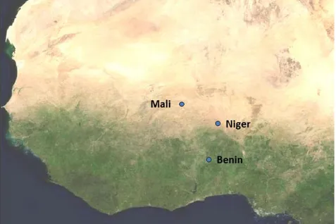
The AMMA programme is an international long-term collaboration to study the climat-ic and environmental feedback mechanisms involved in the Afrclimat-ican monsoon, and in some of its consequences on society and human health. The programme, which started in 2004, has developed a network of ground-based observation stations over Sub-Saharan West Af-rica, and several intensive measurement campaigns (see Redelsperger et al., 2006). In par-ticular, three meso-scale sites were implemented in Mali (de Rosnay et al., 2009), Niger (Pellarin et al., 2009a) and Benin (Pellarin et al., 2009b), providing a huge amount of in-formation on soil moisture and many other variables (see Figure 1). In the present paper, we focused on the point measurements taken in the meso-scale site at Tondikiboro in Ni-ger.
Figure 1. Location of the three meso-scale sites of the AMMA programme.
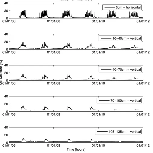
Tondikiboro station provides six soil moisture measurements over the soil profile start-ing from 5 cm of depth down to 135 cm. In particular, the installation is composed by two horizontal probes at the depth of 5 cm and 4 vertical probes that provide a measure over a layer comparable to the probe length (about 30 cm). Measurements are taken with a water content reflectometer (CS616 - Campbell Scientific Inc., Logan, Utah, USA) that are dis-posed along the soil column with the geometry schematically described in Figure 2.
C S6 16 C S6 16 C S6 16 C S6 16 CS616 CS616 -10cm -40cm -70cm -100cm -105cm -135cm 0cm
The values of soil moisture at various depths are depicted in Figure 3, where the value at 5 cm represents the average between the two probes. This redundancy is necessary in order to obtain more reliable soil moisture measurements given the strong variability of surface measurements. The panels of Figure 3 provide a complete picture of the temporal dynamics of soil moisture over a period of about six years (1 January 2006–31 December 2011). Soil moisture measurements contain a limited number of gaps that can be clearly identified in the time series. In particular, the gap of surface measurements in the first 5 months (from the 1/01/2006 up to the 20/05/2006) has limited the application of the filter SMAR in that period.
Figure 3. Time series of hourly soil moisture at different depths measured at the station of
Ton-dikiboro in Niger. Point measurements provide a good description of the soil moisture variations along the soil profile with 5 measurements at different depths ranging from 5cm down to 135 cm. Data refers to the period 1 January 2006–31 December 2011.
Hourly time series have been aggregated at daily scale with the aim to evaluate the ac-ceptability of our simplifying assumption for the present study case. For our analysis, we compared the time series of relative saturation of soil in the first 10 cm, measured through the horizontal probe at 5cm, and the averaged value of the relative saturation of soil in the lower portion of soil (10–135cm). These two values are named respectively S10 and S10-135.
The time series contains some useful information that may be used in the model pro-posed. In particular, the loss rate can be estimated by the relative changes in the soil
mois-01/01/060 01/01/08 01/01/10 01/01/12 20 40 Station of Tondikiboro 5cm − horizontal 01/01/060 01/01/08 01/01/10 01/01/12 20 40 10−40cm − vertical 01/01/060 01/01/08 01/01/10 01/01/12 20 40 70−100cm − vertical 01/01/060 01/01/08 01/01/10 01/01/12 20 40 Time [hours] 105−135cm − vertical 01/01/060 01/01/08 01/01/10 01/01/12 20 40 Soil Moisture [%] 40−70cm − vertical
ture or relative saturation observed at the daily scale. These empirical estimates of soil wa-ter losses can be plotted as a function of the relative saturation of the soil in order to verify the reliability of the hypothesis of linear losses. The graphs of Figure 4 provide a descrip-tion of the relative changes in the soil saturadescrip-tion as a funcdescrip-tion of the saturadescrip-tion for the first (Figure 4.A) and the second layer (Figure 4.B). The scattering observed may be due to the seasonality of the process and to the presence of rainfall, but in the complex the linear ap-proximation seems reasonable. In addition, one can immediately identify, by tracing on this scatterplot a linear trend, the value assumed by the parameter sw as the intercept
be-tween this line and the x-axis.
Figure 4. Relative changes of the soil saturation as a function of the relative saturation of the soil in
the first (A) and second layer (B).
4. Model validation
The SMAR approach was applied to soil measurements available in West Africa and in particular for the Tondikiboro station in Niger. These soil moisture measurements form an excellent database that well describes the soil moisture along the root-zone profile. Ac-cording to this, we have used the surface soil moisture measurements at 5 cm depth to pre-dict the soil moisture in the lower layer of the soil where the relative saturation is measured at various depths.
SMAR contains four parameters that can be related to physical characteristics of the soil profile analyzed. We assigned to each of those a value consistent with the physical characteristics of the site under investigation:
- The parameter 𝑠! was set equal to 0.085. This value was defined as the intercept be-tween the empirical soil water loss function and the x-axis.
- The parameter 𝑠!! was set equal to 0.143 to the soil texture. Considering that the soil is sand, this parameter can be obtained from values of field capacity taken from the literature (Cosby et al., 1984).
- Parameter 𝑎 = 𝑉/(𝑛𝑍! (1 − 𝑠!)) is computed based on the physical characteristics of the soil using the following value for n = 0.35; 𝑍! is the depth of the second layer of soil (that is assumed equal to 1250 mm) and finally the value of the soil water
0 0.1 0.2 0.3 0.4 0.5 0 0.02 0.04 0.06 0.08 0.1 0.12 0.14 0.16 s10(tj) [−] s10 (tj )− s10 (tj− 1 ) [ − ] (A) 0 0.1 0.2 0.3 0.4 0.5 0 0.005 0.01 0.015 0.02 0.025 0.03 s10−135(tj) [−] s10 − 135 (tj )− s10 − 135 (tj− 1 ) [ − ] (B)
losses is set equal to 20 mm day taking into account both the high permeability of the soil and also the high evapotranspiration losses observed in this specific site. - Finally, the parameter 𝑏 is estimated assuming the first layer of soil of 10 cm and the
second one considered with a depth of 1250 mm.
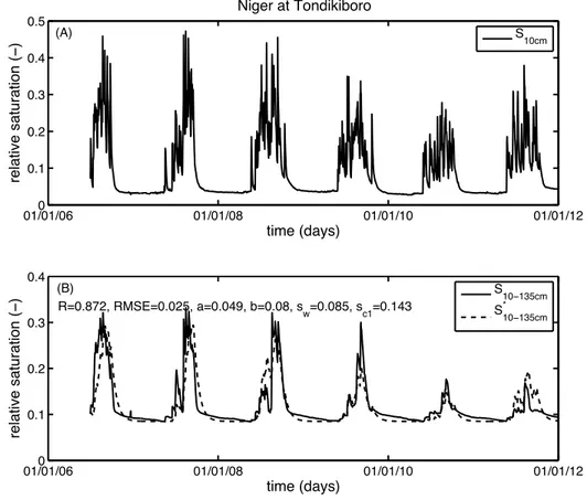
The results of this application are given in Figure 5, where one can see the good per-formance of the method in capturing the trend of the signal as well as the small scales fluc-tuation. The graph provides a description of the application of the SMAR, with a correla-tion of R=0.87 and a root mean square error (RMSE) of 0.025.
Figure 5. A) Time series of relative saturation, at the daily time-scale, in the first layer of soil
meas-ured at the station of Tondikiboro in Niger. B) Averaged relative saturation in the lower layer of soil measured (continuous line) and filtered (dashed line) at the station of Tondikiboro. Parameters values used in the present application are a=0.049, b=0.08, sw=0.085, and sc1=0.143, respectively.
5. Conclusions
In this paper, we applied a new methodology (SMAR) introduced by Manfreda et al. (2012) for the description of soil moisture in the root-zone based on the time series of sur-face measurements. The SMAR has a physically consistent structure with parameters that may be estimated from the physical characteristics of the site under investigation. The methodology was tested, using available information in order to infer parameter values, providing a prediction of the relative saturation of soil in the root-zone at Tondikiboro in
01/01/060 01/01/08 01/01/10 01/01/12 0.1 0.2 0.3 0.4 0.5 time (days) relative saturation ( − ) Niger at Tondikiboro S10cm 01/01/060 01/01/08 01/01/10 01/01/12 0.1 0.2 0.3 0.4 R=0.872, RMSE=0.025, a=0.049, b=0.08, sw=0.085, sc1=0.143 time (days) relative saturation ( − ) S10−135cm S*10−135cm (B) (A)
Niger. The application carried out without the need of calibration provided a satisfying re-sult both in terms of R-values and RMSE. The skill of the method is therefore encouraging and there is potential to use the method to derive root-zone soil moisture from satellite re-trievals.
Acknowledgements. Authors would like to thank Thierry Pellarin for his evaluable help and
comments and for providing the time series of soil moisture measurements.
References
Albergel, C., Rudiger, C., Pellarin, T., Calvet, J.-C., Fritz, N., Froissard, F., Suquia, D., Petitpa, A., Piguet, B., and Martin, E., 2008: From near-surface to root-zone soil moisture using an exponential filter: an as-sessment of the method based on in-situ observations and model simulations, Hydrol. Earth Syst. Sci.,
12, 1323–1337.
Cosby, B. J., Hornberger, G. M., Clapp, R. B. and Ginn, T. R., 1984: A Statistical Exploration of the Rela-tionships of Soil Moisture Characteristics to the Physical Properties of Soils, Water Resour. Res., 20, 682–690.
de Rosnay, P., Gruhier, C., Timouk, F., Baup, F., Mougin, E., Hiernaux, P., Kergoat, L., and LeDantec, V., 2009: Multi-scale soil moisture measurements at the Gourma meso-scale site in Mali, J. Hydrol., 375, 241–252.
Entekhabi, D., Njoku, E.G., O'Neill, P.E., Kellogg, K.H., Crow, W.T., Edelstein, W.N., Entin, J.K., Good-man, S.D., Jackson, T.J., Johnson, J., Kimball, J., Piepmeier, J.R., Koster, R.D., Martin, N., McDonald, K.C., Moghaddam, M., Moran, S., Reichle, R., Shi, J.C., Spencer, M.W., Thurman, S.W., Leung Tsang, Van Zyl, J., 2010: The Soil Moisture Active Passive (SMAP) Mission, Proceedings of the IEEE, 98(5), 704-716.
Green, W. H. and Ampt, G., 1911: Studies of soil physics, part I – the flow of air and water through soils, J.
Agr. Sci., 4, 1–24.
Laio, F., 2006: A vertically extended stochastic model of soil moisture in the root zone, Water Resour. Res.,
42, W02406, doi:10.1029/2005WR004502.
Manfreda, S., Brocca, L., Moramarco, T., Melone, F., and Sheffield, J., 2012: A physically based approach for the estimation of root-zone soil moisture from surface measurements, Hydrol. Earth Syst. Sci.
Dis-cuss., 9, 14129-14162, doi:10.5194/hessd-9-14129-2012.
Manfreda, S., Lacava, T., Onorati, B., Pergola, N., Di Leo, M., Margiotta, M. R., and Tramutoli, V., 2011: On the use of AMSU-based products for the description of soil water content at basin scale, Hydrol.
Earth Syst. Sci., 15, 2839–2852.
Manfreda, S., Scanlon, T.M., Caylor, K.K., On the importance of accurate depiction of infiltration processes on modelled soil moisture and vegetation water stress, Ecohydrology, 3, 155-165, 2010.
Pan, F., Peters-Lidard, C.D., and Sale, M. J., 2003: An analytical method for predicting surface soil moisture from rainfall observations, Water Resour. Res., 39, 1314, doi:10.1029/2003WR002142.
Pellarin, T., Laurent, J. P., Cappelaere, B., Decharme, B., Descroix, L., and Ramier, D., 2009a: Hydrological modelling and associated microwave emission of a semi-arid region in South-western Niger, J. Hydrol.,
375, 262–272.
Pellarin, T., Tran, T., Cohard, J.-M., Galle, S., Laurent, J.-P., de Rosnay, P., and Vischel, T., 2009b: Soil moisture mapping over West Africa with a 30-min temporal resolution using AMSR-E observations and a satellite-based rainfall product, Hydrol. Earth Syst. Sci., 13, 1887–1896, doi:10.5194/hess-13-1887-2009.
Porporato, A., Daly, E., and Rodriguez-Iturbe, I., 2004: Soil water balance and ecosystem response to climate change, Am. Nat., 164, 625–632.
Puma, M. J., Celia, M. A., Rodriguez-Iturbe, I., and Guswa, A. J., 2005: Functional relationship to describe temporal statistics of soil moisture averaged over different depths, Adv.Water Resour., 28, 553–66. Ragab, R., 1995: Towards a continuous operational system to estimate the root zone soil moisture from
in-Redelsperger, J.-L., Thorncroft, C. D., Diedhiou, A., Lebel, T., Parker, D., and Polcher, J., 2006: African Monsoon Multidisciplinary Analysis: An International Research Project and Field Campaign, Bull. Am.
Meteorol. Soc., 87, 1739-1746.
Rodríguez-Iturbe I., Isham, V., Cox, D.R., Manfreda, S., Porporato, A., 2006: Space-time modeling of soil moisture: stochastic rainfall forcing with heterogeneous vegetation, Water Resour. Res., 42, W06D05. Sabater, J. M., Jarlan, L., Calvet, J.C., Bouyssel, F., and De Rosnay, P., 2007: From Near-Surface to
Root-Zone Soil Moisture Using Different Assimilation Techniques, J. Hydrometeorol., 8, 194–206.
Wagner, W., Lemoine, G., and Rott, H., 1999: A method for estimating soil moisture from ERS scatterome-ter and soil data, Remote Sens. Environ., 70, 191–207.