Scienpress Ltd, 2013
Hydrology of the most Ancient Water Harvesting Schemes
Nadhir Al-Ansari1, Mariam Al-Hanbaly2 and Sven Knutsson3Abstract
The Middle East area and in particular Jordan suffer from water shortages. It is believed that water harvesting techniques can solve part of the problem. Jawa and Umm El-Jimal water harvesting schemes were established 6000 and 2000 years ago respectively. They are considered as the most ancient water harvesting scheme. The engineering design and techniques used in those schemes are very unique.
The adaptation of the engineering techniques used in the ancient schemes in the newly established schemes will help to save energy and minimize the evaporation losses. In addition, harvested water can be used for ground water recharge.
Keywords: Water harvesting, Umm El-Jimal, Jawa
1 Introduction
The Middle East region is considered to be an arid or semi-arid area where water in most of the area is scarce. Jordan is the poorest country in its water resources in that region. The area of Jordan is 89,342 km2 and its population reaches 6,508,271. The climate does not allow the country to have excess water resources. Jordan can be classified as a semi-desertic area. Only the highlands, with width of around 30km and length of some 300km enjoy a Mediterranean type climate [1].
Jordan depends on conventional and non-conventional water resources in an attempt to meet the increasing demands. The former are:
Surface water: This includes base flow and flood flow. The former is the water derived from groundwater drainage through springs, and it is estimated that the total average annual runoff is 686MCM [2].The main surface water sources are from
1Lulea University of Technology, Sweden,
e-mail:nadhir.alansari@ltu.se
2Al al-Bayt University, Jordan,
e-mail:mar_hanbaly@yahoo.com
3
Lulea University of Technology, Sweden, e-mail:Sven.Knutsson@ltu.se
Yarmuk River, the side valleys of River Jordan, Hasa valley and the side valleys of Aghwar.
Ground water: In Jordan, ground water depends mainly on rainfall and it is the most important resource that can be tapped, varying in quantity and quality and at depths up to 1000m. Ground water in Jordan is of two types, renewable and fossil, the latter making up 5% of the total storage [2]. An example is Azraq and Desi basins. Non-conventional resources in Jordan include waste water treatment; water harvesting and desalinated water [3 and 4].Water harvesting was simply defined by FAO [5] as collecting runoff for productive uses.
The quantity of the run-off water depends upon a large number of factors, the most important of which are the amount of rainfall and its intensity, climate, vegetation, and the geological, geographical and topographical features of the area. It may vary from 20 % in arid and sandy areas where the rainfall is low and more than 50 % in rocky areas in which the rainfall is high. The rest of the water either infiltrates the ground or is lost by evaporation, transpiration and absorption. Inhabitants in Jordan used this technique thousands of years ago.
The desert “Badia” is around 85% of the total area of Jordan but occupied by only 5% of the population. Hence, it is nationally considered to be the resource depth for the country. The 15% of the total area of the country (urban areas) are not able anymore to absorb the expanding population which reached 3.6% [4]. Therefore, people have started to move to the Badia.
The aim of this research is to investigate one of the potential water resources in the Jordanian desert that can help to alleviate the water shortage problem. This potential resource is water harvesting. Water harvesting is not a new technique for obtaining water. Jordan is considered the cradle of many of the Middle Eastern civilizations and a witness to the evolution of a lot of water harvesting systems, and there are many of them were his restoration and thus benefit from them at the present time, while the rest were left to be a witness to the civilization ago. Two of the most ancient water harvesting schemes was investigated. These are Jawa and Umm El-Jimal schemes dating back to about 5000 and 2000 years ago respectively. The investigation of these schemes will help to implement today the techniques used in the Jordanian desert in the past.
Water harvesting is common in the rural areas of Jordan where rainwater is collected from the roofs of houses and stored in concrete-lined wells. This can be expanded by building larger reservoirs to collect the water, and it is estimated that the water harvesting reached 6MCM per annum by the year 2000 [2]. It has been practiced for thousands of years, especially in Jordan where the climate favors such schemes.
The Badia region of Jordan it is not a region without rainfall. There are some significant amounts of rain in the Badia. In a dry year the annual rainfall is between 25mm to 150mm while in wet years the rainfall is between 50mm to 250mm. This implies that the total volume of rainfall received by the area is about 2.7, 3.7 and 1.6 billion cubic meter/year in a normal, wet and dry year respectively [6]. This implies that there are enough quantities of water but most of it evaporates before it infiltrates into the ground where approximately 92% of the rainfall evaporates, and the rest floods the area for few weeks [7].
2 Methodologies
In this research, aerial photographs (scale 1: 60000 and 1:25000) dated 1953 were used to calculate the catchment area for Jawa and Umm El-Jimal water harvesting schemes. Thirty photos were used for this purpose. The geometric correction was carried out using PCI Geomatics 6.3 program. The method used was Image to Image Geometric Correction and it was applied to all the aerial photographs. Then mosaic photos were constructed for the two schemes using ENVI 3.5 software. The catchment area was calculated using ARC view software. To see the variation of the catchment area with time, the areas were recalculated using topographic maps dated 1995/97 (scale 1:50000). These maps were scanned and digitized using AutoCAD 14 software. Edit Digitizing was carried out using Geomedia Professional software. For more details see [8, 9 and 10].
To get an idea about the prevailing rainfall at the time when the considered schemes were implemented, the data given by Al-Hanbali [11] about the climatological cycles in Jordan were applied to the rainfall record of the area under consideration. This was achieved using the rainfall record of Mafraq rainfall station for the period 1936-2011. It was found that the correlation coefficient between the climatic cycles and annual rainfall was 0.846. In addition, the result indicated that the rainfall behavior can be explained due to the changes in the climatic cycles up to 70%. The standard deviation of the unexplained model was 44.22337. The model obtained had 95% confidence level.
3 Water Harvesting Schemes
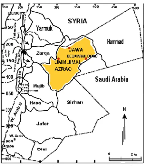
Two of the most ancient water harvesting schemes were chosen for this research (Jawa and Um Jimal) (Fig.1) to investigate the changes in their catchment and to predict the rainfall expected at the time when these schemes were implemented.
Figure 1: Jawa, Um Jimal and Beqawaiah water harvesting schemes.
3.1 Jawa Water Harvesting Scheme
north-east Amman (Figure 1). This scheme was established about 5000 years ago. It represents the history of urbanization that has, nevertheless, preserved a potential recognition of prehistoric scientific ideas [12], and it is a typical example of how from the early ages’ inhabitants of arid regions relied on surface waters resulting from winter rains which was collected and stored in man-made reservoirs or cisterns. Wadi Rajil was the major supplier of water for the town. This wadi extends 35 km north to its source in Jabel Alderouz in Syria, and its width is about 8 km. About 70 million cubic meters of water is collected by this wadi, of which 2 million cubic meters reach Jawa city. Helmes [12] stated that Jwaa water harvesting scheme can collect 70000 m3 representing 3% of the total discharge of the wadi.
The water was retained by deflection and not by total damming where these constructions directed only part of water from the big valley to the canals leading to the storage areas (Figure 2). To achieve this, it requires good knowledge of weather patterns, hydrodynamics, surveying and earth mechanics but above all required the understanding of basic science in terms of observation, recording, evaluation and prediction [12]. The system is composed of deflection areas, gravity canals, dams and pools (Figure 2).
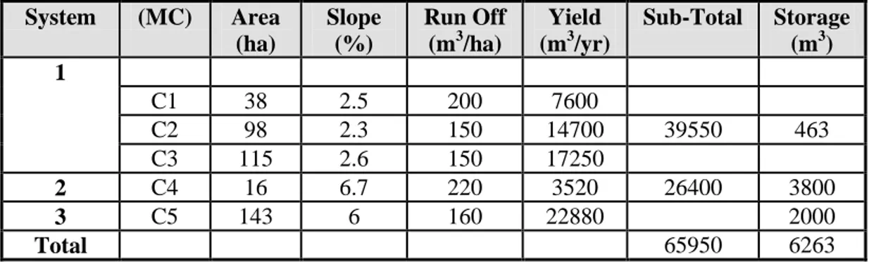
The water system in Jawa can be subdivided into three sub-systems (Table 1). These sub-systems also represent the three catchment areas that the city depended on.
Table 1: The main systems of Jawa water harvesting scheme (modified after Helms,1981) Storage (m3) Sub-Total Yield (m3/yr) Run Off (m3/ha) Slope (%) Area (ha) (MC) System 1 7600 200 2.5 38 C1 463 39550 14700 150 2.3 98 C2 17250 150 2.6 115 C3 3800 26400 3520 220 6.7 16 C4 2 2000 22880 160 6 143 C5 3 6263 65950 Total
First system: The system includes a main canal that transport the water from the deflection area “Da1”to the sluice gates so that the water can be stored in an underground reservoir “P1” (Figure 2). The access water in the canal continued to another overflow where it fills three water reservoirs usually used for drinking purposes. The second branch of the main canal bypasses the storage area, passed through fields and reaches an animal watering point [12]. Access water returns to wadi Rajil. Additional run-off was captured by three linked micro-catchments through a deflection wall, which lead the water either along the bypass canal, or to the three reservoirs.
Second system: This system extends from second deflection dam opposite the eastern quarter of the central part of the town “DaII” and raises water along the steep easterly shore of wadi Rajil that transports the water through the canal to slice gate “S9” and finally to pounds “P6 and P7” [12] (Figure 2). Micro catchment was added and thus increased the area by a long canal, and the run-off from the micro catchment passes through a number of fields to a pool.
Third system: This system extends from third deflection dam at the area “DaIII”, the water is transported through a canal by gravity to a number of outflow gates and three
pounds “P8, P9 and P10” [12]. Again this system also had a micro-catchment area.
Figure 2: Jawa water harvesting scheme A: General overview of the system B, C: Storage scheme in system 1and 2 respectively D: Storage areas of system 3 (modified after Helms,
1981).
Dams in Jawa were mainly built from stone at the upstream and stone reinforcement downstream with an earth fill in the middle (Figure 3). Hard clay, silt and packed layers of ashes were used to build the middle core [12]. Ash was used for the outside layers of the core, and the remainder consisted from silt and clay. The use of ash as a water-resistant material has proven to be very effective and is better than compressed silt or clay. The base of the upstream was constructed from a stone paved surface to protect the dam from any wave action that may have affected its structure. The dimensions of an average dam were between 4 to 5m in depth at the deepest point of the reservoir and had a total length of approximately 80m [12]. Dams may have been longer, but no evidence exists to support such a theory [4].
Figure 3: Sketch of dam in Jawa [12].
Stone, ash and silt were the main components of the walls of the pools (reservoirs) where they were built using the same technique used in building the dams (Figure 4). The first pool acted like an aquifer near the surface of the basalt, and this was because of a natural lava flow cave. The water was sent to this underground reservoir from the main gravity canal of the first system. To protect animals from falling in, a small enclosure made out of stone blocked the entrance to the reservoir. The cave looked like it had been constructed by men, and the roof was artificially reinforced from the inside. The fact that this reservoir was underground increased its efficiency due to minimum evaporation of the water during the hot summer months. The numbers of pools in the entire scheme were 10 (Table 2) where the first 5 pools belonged to the first system, pools number 6 and 7 belonged to the second system, and the remainder pools belonged to the third system. Helms stated that the pools of the three systems can be filled in 24, 2 and 1 hours respectively. The siltation of reservoirs was useful to fill any gaps between the basalt rocks to prevent any leakage and when it was removed it was used for house building.
Figure 4: Pools in the third system in Jawa [12].
The micro-catchment area was just over 1km2 they are very important keeping the water balance in the town [12]. These were used as a safety net in the case that their main water resource didn’t provide them with the water they needed because the water from wadi Rajil is variable in time and volume.
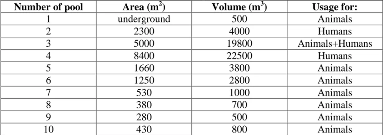
Table 2: Capacities of the pools (Helms, 1981).
Number of pool Area (m2) Volume (m3) Usage for:
1 underground 500 Animals 2 2300 4000 Humans 3 5000 19800 Animals+Humans 4 8400 22500 Humans 5 1660 3800 Animals 6 1250 2800 Animals 7 530 1000 Animals 8 380 700 Animals 9 280 500 Animals 10 430 800 Animals
3.2 Umm El-Jimal Water Harvesting Scheme
Umm El-Jimal is located north of Jordan, and it is 86 km from Amman and 20 km east Mafraq (Figure 1). The city and its water system dates back to 324 – 64 BC [13 1nd 14]. The water harvesting system is composed of dams, channels and underground reservoirs. The dams are located in higher parts of the mountains to collect and divert the water to the channels and then to the reservoirs. Rainfall events are short and intensive but the
evaporation rate is very high [15]. These extreme conditions forced the people of the area to develop adequate technology to collect and store the water to be used.
1. Dams: Three dams were built in this area. They were built using basaltic rocks, which were covered by white plaster mixed with gravel. They had no moving parts except for one, which had something like a release valve which was triggered manually in case of flooding in the area. The first dam was the smallest, and it was 1.7 m high and it is directly connected to the second dam which is O.8 m high. The second dam was a diversion dam that has the capability of diverting 100,000 m3/hour [15]. The third dam was 32 m long and about 1.4 m high.
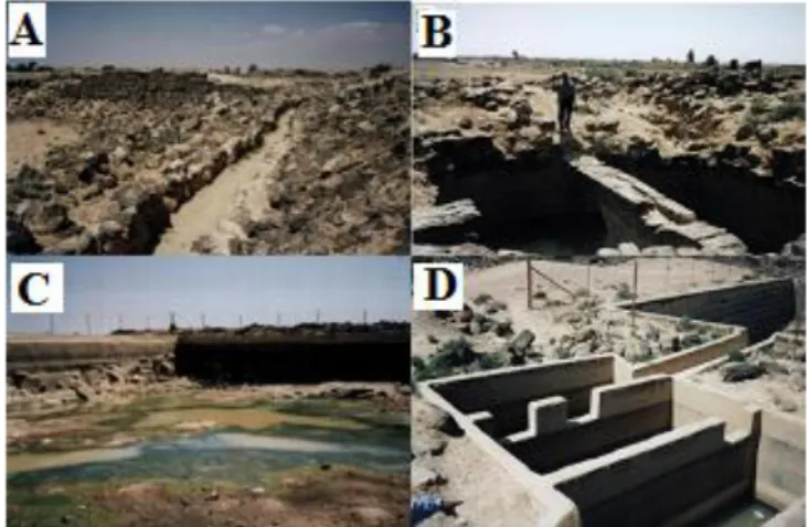
2. Canals: A network of surface canals that carried the water inside the walls of the town were connected with the dams [15]. The length of the main canal reaches 4 km. Outside the city, the dimensions of the canals were between 30 - 60cm in width and 20cm and 60cm in depth while inside the city the dimensions were 120 - 80cm in width and between 60 - 50cm in depth (Figure 5 A). There are others side canals were used to distribute water inside the city. Basalt was used in constructing the canals. The canals' distribution was achieved using sluice gates. Thatched canals were used between reservoirs inside the city.
3. Umm El-Jimal reservoirs: There are number of open and covered reservoir inside and outside Umm El-Jimal city. Ten covered pounds were constructed inside the city. Three had cylindrical shape, 4 rectangular shapes, 2 egg-shaped shapes and 1 semi-circle shape (Table 3). Twenty eight open ponds are found inside and outside the city. The design was simple [16] (Figure 5). The overall storage capacity of the reservoirs reaches 7063.3 m3 [17]. The water stored in covered reservoirs to prevent evaporation and to protect the public and animals from falling in since most of the reservoirs where inside the town limits. The water was treated in Umm El-Jimal by removing the suspended solids. This was achieved using a small settling tank with three different compartments before the main reservoir as can be seen in figure 5D. The tank had a
total capacity of 40.836m3 and each one of the three compartments had a capacity of 13.612m3.The depth of the tank was 2.05m.
Figure 5: Umm El-Jimal water harvesting scheme. A: canal from the dams to the city, B: Underground water cistern, C: Reservoir area, D: Settling tank.
Table 3: Dimensions of the reservoirs at Umm El-Jimal.
Reservoir Type Length Width Depth Diameter Capacity
1 rectangular 39.7m 29.9m 4.3m 5144.229m3 2 egg-shaped 12.8m 8.5m 4m 435.2m3 3 cylinder 4.5m 9m 286.4m3 4 semi-circle 2.5m 10m 196.4m3 5 rectangular 8.5m 6.2m 3.06m 189.72m3 6 egg-shaped 15.5m 10.2m 3m 474.3m3 7 cylinder 2.2m 6.2m 66.4m3 8 rectangular 5.5m 4.7m 2.2m 58.87m3 9 rectangular 5.6m 4.1m 2.5m 57.4m3 10 cylinder 2.5m 8.9m 100m3 Total 7063.255m3
4 Results and Discussion
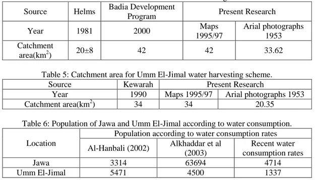
The results of the catchment area calculations for Jawa water harvesting scheme using aerial photographs dated 1953 indicates that it was 33.62 km2 and it increased to 42km2when using topographic maps dated 1995/97. This result is in agreement with the areas calculated by [12 and 18] as tabulated in table 4. This implies that the catchment area increased by 2.1% taking into consideration that the climatic cycle is 15 years (table 4). If this is the case, then the area of Jawa 6000 years ago was approximately 1 km2.
The same is true for Umm El-Jimal catchment where the catchment area was 20.35 km2when using aerial photos of 1953 and increased to 34km2 when 1995/97 topographic maps were used (see Table 5). This implies that the catchment area 2000 years ago was about 33km2.
To have an idea about the population in Jawa and Umm El-Jimal at the time of implementation, water consumption was used an indicator. Al-Hanbali [11] suggested that it was 5.524 m3/year/capita while Alkhaddar et al (2003) suggested that it was about 1.57 m3/year/capita. Using these figures the population of Jawa varies from 3314 to 63694 and Umm El-Jimal from 5471 to 4500 (see table 6). When present consumption rates are used then the population in Jawa and Umm El-Jimal will be 4714 and 1337 respectively.
Table 4: Catchment area for Jawa water harvesting scheme.
Source Helms Badia Development
Program Present Research
Year 1981 2000 Maps 1995/97 Arial photographs 1953 Catchment area(km2) 20±8 42 42 33.62
Table 5: Catchment area for Umm El-Jimal water harvesting scheme.
Source Kewarah Present Research
Year 1990 Maps 1995/97 Arial photographs 1953
Catchment area(km2) 34 34 20.35
Table 6: Population of Jawa and Umm El-Jimal according to water consumption. Location
Population according to water consumption rates Al-Hanbali (2002) Alkhaddar et al (2003) Recent water consumption rates Jawa 3314 63694 4714 Umm El-Jimal 5471 4500 1337
In order for water harvesting to be more effective to cover the water shortages in Jordan, some of the ancient techniques should be used in the new systems using the examples of Jawa and Umm El-Jimal. In implementing such schemes, water losses due to evaporation should be taken into consideration. The evaporation rates are high where annual mean evapo-trasperation is about 1983mm and the annual mean open water evaporation is 2465mm [19]. To overcome the evaporation rates lava tubes that are present in the Badia region can be used or harvested water from the desert could be collected and returned in natural underground reservoirs. This could be achieved by actually pumping the water into the natural underground reservoir or let it infiltrate naturally. To avoid siltation problems during infiltration, the technique used in Umm El-Jimal should be used to get rid of solid particles incorporated with the harvested water. The selection of the location of the reservoirs is important so that no extra energy is required for the transfer of the water. The location of these artificial reservoirs should be such that the water is transferred to them by gravity as in Umm el-Jimal and Jawa.
5 Conclusions
The technique used in the ancient water harvesting techniques in Jordan provide us with valuable information, which will help us to understand the parameters involved in water
harvesting and how we can improve our recently implemented schemes. The systems in Jawa and Umm El-Jimal were designed in such a way that evaporation losses and energy for transporting the harvested water were minimized. In addition, the technique used to prevent siltation should be adopted. Basaltic lava tubes can be used for water storage and harvested water can be also stored in underground aquifers.
ACKNOWLEDGEMENTS: The research presented has been financially supported by Luleå University of Technology, Sweden and by "Swedish Hydropower Centre - SVC". SVC has been established by the Swedish Energy Agency, Elforsk and Svenska Kraftnät together with Luleå University of Technology, The Royal Institute of Technology, Chalmers University of Technology and Uppsala University. The support is highly appreciated.
References
[1] Salameh, E. and Bannayan, M., Water resources of Jordan Present status and future potentials, Friedrich Ebert Stiftung, Amman, Jordan 1993.
[2] Hussein, I. and Al-Jayyousi,O., ‘Evaluating Water-Importation options in Jordan: Opportunities and Constraints’ published in the CIWEM Journal Vol.13 August 1999.
[3] MMRA “Ministry of Municipal and Rural Affairs - Environment Department of Environment”, National Environment Strategy for Jordan: A resource Book of Information and Guidelines for Action, The Economic Press Co., Jordan, 1991. [4] Alkhaddar, R., Papadopoulos, G. and Al-Ansari, N., Water Harvesting Schemes in
Jordan, International conference on efficient use and management of urban water supply, paper 10087, Tenerife, Spain, 2003.
[5] (FAO), Food and Agriculture Organization, A Manual for the Design and Construction of Water Harvesting Schemes for Plant Production, The United Nations Rome, edited by Will Critchley 1991.
[6] Water and Environment in the area east of Mafraq and their development potentials, report No 2, Strategic Environment and Water Research Unit, Al al-Bayt University, Water Authority of Jordan 1998.
[7] Salameh E. and Garber, A., ‘Jordan’s Water Resources and their Future Potential, Proceedings of the Symposium 27th and 28th October 1991, Friedrich Ebert Stiftung, Amman, Jordan 1992.
[8] Wilkie, D. and Finn, J., Remote Sensing Imagery for Natural Resources Monitoring, Columbia University Press, U.S.A 1996.
[9] Ali, M., GIS: Arabic geography and information era, Dar Alsafa, Amman. 1st Edition (in Arabic) 2001.
[10] Eastman, R., IDRISI Taiga guide to GIS and Image processing, Clarks Lab, USA. Maual version 16.02, 2009.
[11] Al-Hanbali, M., Ancient and Modern Water Harvesting Schemes: A Comparative Approach Using Remote Sensing Techniques, M.Sc. Thesis, Al al-Bayt University (in Arabic), 2002.
[12] Helms, S.W., ‘Jawa, lost city of the black desert’, Methuen & Co. Ltd, London, UK, 1981.
[13] Bowersock, G., Roman Arabia, Master Thesis, Harvard University, Cambridge (1983).
[14] Parker, S.T., Romans and Saracens: A history of the Arabian Frontier, American Schools of Oriental Research, 1986.
[15] Khoera, A. M. Y., The irrigation system in Umm el-Jimal, Master Thesis Antique/Archeology, Yarmook University, Irbid, Jordan, 1990.
[16] Oleson, J.P., ‘The origins and design of Nabataean water supply system’, Studies in the history and archaeology of Jordan, Volume V, Department of Antiquities, Amman, Jordan, 1995.
[17] Evenari,M., The Negev. The Challenge of a Desert, 2nd edition, Cambridge, 1982. [18] Badia Research & Development Programme, Technical Report (CS/2000/Badia.2):
Evaluation of the Existing Water Harvesting Systems, Safawi Station, Badia Research & Development Programme, 2000.
[19] [19] Al Ayash, S.M., A development of water harvesting system at Safawi area in Northern Jordan Badia, Civil engineering department, MSc thesis, Jordan University of Science and Technology, Irbid, Jordan, 1993.

![Figure 3: Sketch of dam in Jawa [12].](https://thumb-eu.123doks.com/thumbv2/5dokorg/5504263.143364/6.813.165.654.115.324/figure-sketch-of-dam-in-jawa.webp)