Climate change in Sweden – geotechnical and contaminated land
consequences
Y
VONNEA
NDERSSON-S
KÖLD,
J
ANF
ALLSVIK,
C
ARINAH
ULTÉN,
A
NNAJ
ONSSON1,
M
ATTIASH
JERPE1,
E
RIKG
LAAS1Swedish Geotechnical Institute (SGI), SE 412 Göteborg
S
WEDENAbstract: - According to climate scenarios the global mean temperature will increase the nearest 50 to
100 year. Regional climate scenarios show increases in annual precipitation and heavy rain events in most parts of Sweden. Accordingly, the risks for flooding will increase. Also the risks of erosion and landslides are expected to increase as well as changed behaviour and increased mobility of soil contaminants. The summer season in general is expected to become drier and there consequently larger fluctuations of groundwater levels is expected further enhancing the risks of erosion, land slides and mobility of soil contaminants. One of the areas expected to be among the most affected in Sweden is the Lake Vänern and the Göta älv (river) system. The Swedish geotechnical institute has, together with other agencies and universities in Sweden, contributed in the national climate and vulnerability inquiry [1]. Here the results from three of those reports are presented, i.e. impact of flooding on soil pollutants [2], increased tapping from lake Vänern and related geotechnical
conditions in the Göta älv valley [3] and overview assessment of land slide changes in a changing climate [4]. Based on the results from the national climate and vulnerability inquiry research projects have been initiated. One project focuses on the vulnerability and adaptive capacity among municipalities along the Göta älv system. The project includes socioeconomic, environmental and geotechnical aspects. The aim is to present some preliminary results from this project.
Key-Words: - Climate change, Sweden, land slides, geotechnical aspects, contaminant mobility
1
Linköping University, SE 581 83 Linköping, SWEDEN, http://www.liu.se
1 Background
Global temperature has increased during the last century, and according to climate change scenarios the increase will continue [5]. A sea level rise is expected due to the global temperature increase. The magnitude of changes will vary geographically and seasonally also in Sweden [6]. In Sweden the temperature increase will be more pronounced in winter than summer, and the snow season will be shorter. Apart from the south east parts of Sweden the annual precipitation is expected to increase in all of Sweden, in some areas by up to 25 % during the nearest century. More rain days are expected, and heavier rain falls. The precipitation increases even over autumn, winter and spring. During those seasons the rain falls will be heavier, but not more than expected from the general increase. During summer the precipitation will be more intense despite the total precipitation decrease. The increased sea water levels, the increased annual precipitation in most parts of Sweden and the changes in precipitation pattern will, of course, also
have impacts on water flows and ground water levels, and more flooding events can be expected [1], [6]. During periods with large precipitation both the water flow and the ground water level will increase. The ground water already today is fluctuating between long rain and draught periods, but the frequency is likely to increase. Increased ground water level and increased fluctuations may result in increased leaching and spreading of pollutants from contaminated sites. Heavy water flow may result in large run off from the top layer bringing increased amounts of humus to surface waters. The result is increased turbidity and darker water. The humus may also carry pollutants [7]. The changes in ground water level and the increased fluctuation will also alter the soil conditions such as the oxygen availability, biological activity, redox and weathering conditions, which alter the risks since the toxicity and the mobility may change by changing the chemical conditions, the sorption processes and the degradation routes and times. Increased probability of erosion and land slides may
result in accidents where high amounts of pollutants to air, soil or water may be released. For example dam ruptures and erosion and land slides in contaminated areas will result in the release of contaminated masses. Here the results from a study of the potential release of pollutants due to flooding of contaminated land and in areas with ongoing industrial activities will be presented based on the work in [2].
Vulnerability to climate change is a critical factor for the possibilities to achieve sustainable
development. A changing climate will also affect city planning in that areas may become unsuitable for development due to increased risks for flooding and landslides. Cities and regions, thus, will increasingly get a key role in assessing the requirements for adaptation [8].
2 Mapping potential changes in
landslide events
To find areas with prerequisites for landslides in areas covered by fine-grained soils, nationwide survey hazard mapping is performed, e.g. in Norway and Sweden. In Sweden this mapping is based on overview information on the slope inclinations and the soil conditions in the mapped areas, roughly the existence of clay and silt layers in the terrain coinciding with slope inclinations greater than a certain angle, primarily 1:10. Especially riverbank slopes can be unstable, and in quite many cases prone for devastating landslides also impacting built-up areas. During the first period of time after flooding, the landslide hazard in the riverbank slopes is increased due to remaining high pore water pressures in low permeable soil layers. Therefore, a further hazard mapping method, where flooding and landslide hazard digital maps have been combined to a map indicating sub-areas with prerequisites for landslides which also can be flooded has been done.
Fig. 1 Simulated increase of the annual runoff in Sweden 2071-2100 compared to reference period 1961-1990 [6].
Fig. 2 Overview estimation of the landslide hazard change in Sweden due to the expected climate change during the coming 70-80 years [4].
2.1
National overview
Built up areas adjacent to rivers, lakes and sea shores will be exposed to flooding, waves and erosion related to the climate changes, in their turn triggering landslides. An overview estimation how the landslide hazards will change during the coming 70- 80 years, is presented in Fig.2. The map is performed by overlay between two index maps indicating the change in expected runoff [6] (Fig. 1) and erosion respectively, and presented in detail in [4].
3 Case studies of landslide risks –
the Göta älv valley
In addition to the overview mapping, a case study area, the Göta älv (Göta river) valley in south-west Sweden was chosen for calculations of potential change in land slide probability. The Göta älv valley runs from Lake Vänern in the north to Göteborg in the south and is one of the most frequent landslide valleys in Sweden. A number of landslides occur every year but in general they are fairly small, shallow and caused by erosion. Limited slides under the water table occasionally also occur. An aerial photo scanning survey conducted in 1982 revealed 150 slide scars in the river valley. Larger landslides have also occurred in the river valley such as Surte, 1950 and Göta, 1957 where one or more people were killed, e.g. [3]. The high frequency of
landslides in the river valley is due to the geological history, which has resulted in deep clay layers. Most of the clays have been deposited in a marine
environment and quick clay is therefore common in the area. Quick clay is a soil where the skeleton collapses due to vibrations, or stirring, and the clay
Increase
Small or no change Decrease
thereafter behaves as a liquid. When a landslide occurs in a quick clay area the process is very rapid and the extent of the slide can be very large, with major consequences. In the northern part of the Göta älv valley the soil depths are moderate. Bedrock is common together with and mixed with sediment areas. The slopes towards the river are in general high and steep. The clays are firm and often contain water-permeable layers. Towards the south of the valley the clays are soft and homogenous and the clay and soil depths increase. In the southern part, riverside shelves and slopes under the water table often occur between the shoreline and the deepest part of the river [3 and references therein].
In 1938, a regulation of Lake Vänern, and thereby also the river (Göta älv) was done to optimise the use of the power stations along the river. The water flow in the river prior the regulation varied between 200 and 850 m3/s and the deviation between normal water flow and high water flow was moderate. After the regulation, water flows higher than 1000 m3/s occur more and more frequently, and also lower water flows (< 200 m3/s) have been permitted. This may have a great impact on the erosion processes and the of slope stability conditions along the river. First attempts to investigate the possible impact of increased precipitation and tapping on slope stability have been made based on tests and sensitivity analysis using methods developed for past and present climatic conditions.
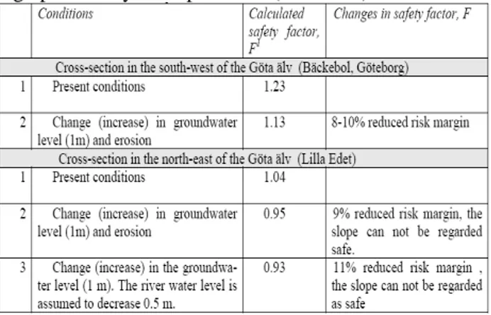
Table 1 Case study scenarios to investigate the possible impact of increased precipitation and water flow in the Göta älv valley. F = Safety factor (> 1 the slope is regarded as safe, < 1 the slope is not regarded as safe, i.e. high probability of slope failure (land slide).
The rise in groundwater level due to increased precipitation is, in this scenario, set 1 m in the clay layer. This may be realistic for precipitation increase of ≥ 40%, which also may occur under present climatic conditions. The scenario with changed tapping and increased maximum flow is expected to result in 50 % increase in the erosion rate,
depending on local conditions. The different scenario conditions for Göta älv valley and the impact on the slope stability (defined as the change in safety factor, F) are described in Table 1 and further details are presented in [3].
4 Contaminated sites and ongoing
activities in flood risk areas
The Swedish MIFO (Methodology for inventory of contaminated land) database and the national Emission Register (EMIR) data base has been used to identify the number of contaminated sites and ongoing activities in the areas which have been identified as flood risk areas by the National mapping of the Swedish Rescue Service. At present around 10 % of the water coarse areas have been flood risk invented [9]. In Sweden around 83 000 potentially contaminated sites have been identified, among those about 15000 have been classified and among those all have not yet been communicated to the land owners [10]. The MIFO inventory is conducted by the 24 county administration boards in Sweden. The data base has been, and still is
continuously updated. During the course of this investigation the relative amount of the sites investigated, classified and communicated varied among the counties. The data obtained from the county administration boards are most often the ones communicated but in some cases the ones classified have been reported. The EMIR database includes ongoing A activities (e.g Larger Airports, Refineries, Medical and Chemical Industries) and B activities (e.g. larger oil tanks, manufacturing industry, garages,). In total 376 ongoing A and B activities and 932 of the communicated
contaminated sites have been identified in the flood risk areas [2]. The variation and difference among them is large and constitutes of previous and/or present activities and the thousands of landfills in Sweden.
4.1 Landfills
The old landfills can contain anything varying from domestic waste to mining waste [11]. Since 1994 the amount of active landfills has decreased and demands have increased. The landfills in use today have been designed to fulfil the national waste directive criteria (SFS 2001:512, NFS 2004:10) based on the climate today. Calculations show that there will be both an increased evapotranspiration and increased water leaching. The relative leaching may increase by more than twice the relative
increase of precipitation for the old landfills. The increased leaching in landfills in use today is around 10 % or less under the same conditions. Under conditions were the landfill is designed to the criteria of 50 mm per year, the increase is however that significant that the criteria can not be fulfilled under conditions with increased precipitation and consequently higher demands on the water collecting systems will have to be taken [11].
4.2 Contaminated land
In order to investigate the potential impact on increased precipitation on contaminated land some calculations have been done. The calculations are based on available information from investigations of contaminated sites of a chemical industry – mercury found above national guideline values at some locations inside the site, wood impregnation – creosote, copper and arsenic found above guideline values at some locations inside the site and an area with mixed industrial land – lead, copper and zinc found above guideline values at some locations inside the site. The soil and water guideline values (Swedish EPA, 2002) are not exceeded outside the sites for any of the activities and this is also the basis for the calculations. The calculations include the following scenarios; i) Today conditions, ii) Increased ground water level and increased water flow – hard surface, no contact between surface and ground water, iii) Increased ground water level and increased water flow – contact between surface and ground water, iv) Land slides to three different waters: one river with a flow of 150 m3/s, a water
coarse 37 m3/s and a lake 90 000 000 m3 with water
residence time 3.1 year.
The calculations including changes in ground water level and water flows were done using Bioscreen®. The landslide calculations are based on a land slide that took place in Ballabo, along the Göta älv in southwest of Sweden, in April 1996 [12]. The slide masses covered 110 meters along the Göta älv and reached around 50 to 70 meters up from the river. The size of the slide is not the largest that have occurred in the area (e.g. Surte, 24 ha, 1950, and Göta, 32 ha, 1957). The landslide lasted around 10 minutes and that is also assumed to be the case in the calculations. The contaminated masses are assumed to follow the water in the river and the water coarse. In reality parts of the masses will deposit just outside and downstream the location of the landslide area. The calculations also include the total amounts of contaminants, i.e. the amount in the contaminated massed, and not the dissolved
chemicals. The results of the calculations therefore present the highest possible amount of contaminants to be found in for example the drinking water reservoir downstream.
4.2.1 Increased ground water levels Increased ground water level may increase the transport by groundwater to surrounding areas significantly due to changes in chemical conditions. For mercury and the contaminants at the
impregnation site, the increase initially is more than ten times and 40% respectively. The increased mobility is mainly due to higher contaminant concentrations and lower Kd (distribution coefficient between adsorbed and dissolved compounds) value in the vadose zone (today). The effect is expected to be reduced if the ground water level stays high, since then the Kd value is expected to become similar Kd in the saturated zone today. Increased water flow further increase the leaching, but the guideline values are not exceeded outside the contaminated site despite the increased leaching. Flooding with increased ground water level and increased water flow with contact between surface and ground water over three days, however, result in a more significant transport to nearby areas. The water speed at the surface has been set to 1 m/s and the flooding event has been assumed to last for three days. The impact on the nearby areas depends on the available amount of pollutant by the surface at the site. When the total amount of contaminant by the surface is limited the flooding event will cause a pollution plume. The highest concentration is rather limited to the front of the plume and follows the water flow. If the amount available is set identical to the total amount at the site, the impact is larger. The maximum concentration is higher, and more even in the water that has passed the site. The surface water concentrations can be well above the guideline values for drinking water. In both cases the concentration depends on the Kd values assumed, the available non hard surface allowing the surface water to get in contact with the contaminated masses in addition to the concentration in the ground and amount available at the surface. The calculations do not include spreading through cracks or particulate bound transport in the soil, nor changes of those due to the flooding events. Nor are changes in the ground conditions due to changes in vegetation and biological activity considered.
Not calculated, but maybe of larger importance, is the impact in a longer perspective. Repeated
flooding may spread pollutants to surrounding areas where they are accumulated on the surface between
each event. By time high surface concentrations may be built up causing risks for grazing animals and oral intake by children.
Calculations of the annual discharge to the Göta älv shows that the pollution discharge, both nutrients and chemical contaminants, will increase in the same order as the increase in precipitation in the area. An increase in precipitation by 25 % results in a discharge increase of 23 %. The pollution load to the river, its sediment and the estuary will be increased to the same extent. The full study includes further case study scenarios and overviews.
4.2.2 Land slide events
More severe impact also in a short time perspective is the occurrence of landslides in contaminated masses. The calculated concentrations of mercury from the chemical industry site is calculated to temporary reach a value of 6 mg/l which is 600 times the drinking water guideline value (Swedish EPA, 2002) and the guideline value will be exceeded for more than 50 minutes after the landslide. The concentrations will be found in principle all the way downstream the river, but at different times. The same event but to the smaller water coarse will lead to higher maximum
concentration but the time for the exceeded drinking water guideline will be the same. Similar results were obtained for the other contaminated sites and contaminants. The same type and size of slide, releasing contaminated mercury masses, but to the lake, will result in total concentration of 0,009 mg/l mercury in the lake and the total concentration will remain over hundred of years. It has to be noted that the calculations are based on one land slide
scenario. If the water flow is higher than assumed for the rivers considered here, the concentration will decrease and the time for the guideline value being exceeded will also decrease. On the other hand, the size of the land slide is relatively small compared to the worst land slide events in Sweden. The larger the slide and the more contaminated the masses the higher the maximum concentration in the waters and the longer time the guideline values are exceeded. In reality all the masses will not be transported with the water as the landslide occurs. Some of the masses will be deposited by the slide area and downstream. By time the masses will be eroded from the bottom and transported down the river. Further details and information about the full study can be found in [2].
5 Cities capacity to manage
vulnerability to climate change
Vulnerability does not only depend on physical risks related to climate change. Localisation and quality of the infrastructure as well as the impacts of socioeconomic change interplay with thebiophysical changes [13]. Accordingly, to estimate vulnerability and adaptive capacity among
municipalities, socioeconomic processes need to be incorporated. A case study based project has been initiated to investigate the vulnerability and adaptive capacity along the Göta älv system by using three methods developed by international research emphasizing different aspects of vulnerability: downscaled socioeconomic scenarios, e.g. [14], climate vulnerability indices, e.g. [15], and double exposure analysis, e.g. [13], as well as a number of tools that are used to project bio geophysical impacts of climate change. The project includes socioeconomic, environmental and geotechnical aspects and aims at investigating the institutional capacity to assess society’s vulnerability to climate change of cities and regions. The project also uses participatory methodology, i.e. it studies how key officials at municipal level interpret the different methods in order to discuss how they could be used to support decision-making on adaptation. Two groups of key-stakeholders from Göteborg and Lilla Edet participates in a series of four workshops / stakeholder meetings. The workshops will cover for instance: selection of common case; discussion and selection of climatic and non-climatic aspects, sectors and activities and factors affecting adaptive capacity to include in the decision support;
presentation and interpretation of decision support and application to other cases. The key officials include representatives from inter alia: city
planning, water and sanitation, railway, traffic, park and environmental administration. The two groups have selected two interesting cases. One major change of the city communication centre in Gothenburg, Sweden’s second largest city, located very low, i.e. highly exposed to high water levels in the Göta älv. The second case involves the
construction of a new residential area in the proximity of Göta älv outside Lilla Edet, a small municipality about 55 km north of Gothenburg. The expected project outcomes are elements that could constitute an integrated vulnerability tool and criteria for robust decision making tailored for planners within municipal and regional administration.
Primary results indicate that rising sea level, high water flows caused by increased precipitation
tapping from Lake Vänern or both and increased probability for storm events are the climate aspects of most concern in the two case studies. In the case studies road and railway infrastructure as well as building and water supply, sanitation and drainage will be subject for deeper studies of vulnerability and adaptive capacity. The temperature increase itself will affect the rail way system. There is, already today, a need of more (frequent and secure) weather prognosis and related warning systems as well as increased organisation capacity to handle crisis situations such as extreme water levels. The further study will include an analysis of how number of already selected economic, political, social as well as demographic and technological factors interplay to create vulnerability to multiple stressors. Climate change adaptation measures are also discussed both in Göteborg and Lilla Edet as part of ongoing planning discussions. To what extent these decisions depend on several factors such as the political will and the financial situation is however unclear.
The key participating stakeholders point to the importance of national, regional and internal economy both regarding the vulnerability, the adaptive capacity and the long term adaptation strategy. Further the awareness, competence and opinion on different political levels (local, regional, national and EU) play an important role on the available funding for implementing adaptation measures and for sustainable municipal planning solutions in general.
6 Acknowledgement
Three studies presented here were funded by the Governmental Climate and Vulnerability Inquiry (M 2005:3) which is gratefully acknowledged. These projects would not have been possible to perform without the data from all county administration boards and other experts which are also gratefully acknowledged. The study enhancing cities capacity to manage vulnerability to climate change depends on the key stake involvement and the participants from Göteborg and Lilla Edet and the funding by Formas which are all gratefully acknowledged. References:
[1] SOU 2007:60 Sverige inför
klimatförändringarna - hot och möjligheter (Sweden and climate change, in Swedish), SOU 200/:60, Ministry of the Environment, Stockholm, Sweden. [2] Andersson-Sköld, Y, Nyberg, H, Nilsson, G, Gustafsson, M., 2008, Flooding and potential risks for pollutants spreading - emissions related to
climate, Proceedings International FZK/TNO conference on soil-water systems, 10, ConSoil 2008, Milan, June 3-6, 2008.
[3] Hultén C, Andersson-Sköld, Y. Ottosson, E., Edstam, T., Johansson, Å., Case studies of landslide risk due to climate change in Sweden, Proceedings Landslides and Climate change - challenges and solutions, May 21-24 2007 on the Isle of Wight, UK [4] Fallsvik, J, Hågeryd, AC, Lind, B, Edsgård, S, Alexandersson, H, Löfling, P, Nordlander, H, Thunholm, B, 2007, Impact of the climate change in Sweden. Overview assessment of soil movements due to climate change. In Swedish, SGI. Varia 571 [5] IPCC, 2007, Climate Change 2007: Impacts, Adaptation and Vulnerability Working Group II Contribution to the Intergovernmental Panel on climate Change Fourth Assessment Report Summary for Policymakers, Brussels, April 2007. [6] Rossby Centre, SMHI, 2007, http://www.smhi.se /sgn0106/leveranser/sverigeanalysen/ (2007-07-19) [7] Johansson, L., 2003, Evaluation of trends in Mälaren- A studie of the water quality at Lovö water agency 1935-2002, in Swedish, Stockholm Vatten R 23.
[8] Bulkeley, H and Betsill, M (2006) Cities and the multilevel governance of global climate change. Global Governance 12(2):141-159.
[9] Näslund-Landemark, B., 2007., Contact person General flood risk mapping, SRV, www.srv.se
[10] Färnqvist, K., 2008, Contaminated land, climate change, planning, in Swedish), Workshop, Göteborg, Sweden, January 21 2008,
http://www.renaremark.se/arkiv/ws080122/
[11] Nilsson, G, Rosqvist, H, Andersson-Sköld, Y, Starzec, P, Norrman, J, 2005, Contaminants and climate change a basis for action plan to predict and prevent natural hazards in Sweden, in Swedish, SGI. Varia 560:3
[12] Andersson, H, Ottosson, E, Sällfors, G (1999) Skredet i Ballabo, Västerlanda, SGI. Rapport 57 [13] Leichenko, R and O'Brien, K. (2002). The dynamics of rural vulnerability to global change:the case of southern Africa. Mitigation and Adaptation Strategies for Global Change 7:1-18.
[14] Kaivo-oja J, Luukkanen J and Wilenius M (2004) Defining alternative national-scale socio-economic and techno-logical futures up to 2100: SRES scenarios for the case of Finland.Boreal Environment Research 9(2): 109-125.
[15] Sullivan CA and Meigh JR (2005) Targeting attention on local vulnerabilities using an integrated indicator approach: the example of the Climate Vulnerability Index. Water Science and Technology 51(5): 69–78.
![Fig. 2 Overview estimation of the landslide hazard change in Sweden due to the expected climate change during the coming 70-80 years [4]](https://thumb-eu.123doks.com/thumbv2/5dokorg/4443930.107708/2.892.150.333.880.1106/overview-estimation-landslide-hazard-change-sweden-expected-climate.webp)