Malmö University
Faculty of Culture and Society Department of Urban Studies
A strategy for unifying a divided city?
Comparative analysis of
counter-segregation policies for three
deprived mass housing districts in Europe
Louise Ekman M.Sc. Urban Studies VT 2017
Anastasiia Shotckaia Course: Making Urban Studies
Inga Stumpp Supervisor: Peter Parker
Table of contents
1. Introduction 2
2. Literature review on urban segregation and integration 3
2.1. History of thought 3
2.2. Definitions of urban segregation 4
2.3. Emergence and intensification 5
2.4. Consequences of urban segregation 7
2.5. Desegregation and integration 8
3. Methods 12
3.1. Selection of cases and used methods 12
3.2. Limitations of the research 13
4. Presentation of case studies 14
4.1. Århus 14
4.1.1. Århus: description of the case 14
4.1.2. Århus: description of the strategy 15
4.1.3. Århus: analysis of the strategy 18
4.2. Malmö 20
4.2.1. Malmö: description of the case 20
4.2.2. Malmö: description of the strategy 21
4.2.3. Malmö: analysis of the strategy 25
4.3. Mannheim 28
4.3.1. Mannheim: description of the case 28
4.3.2. Mannheim: description of the strategy 28
4.3.3. Mannheim: analysis of the strategy 32
5. Comparative analysis of the cases 34
5.1. Possibilities of counter-segregation 34
5.2. Strengths and weaknesses of the strategies 36
5.3. Conceptualisation or circumstances? 38 6. Conclusion 39 7. References 41 8. Appendix 45 8.1. Interview guideline 45 8.2. List of interviewees 46
1. Introduction
The exclusion of certain districts within cities is a common phenomenon in Europe and much has been written on the causes and effects of urban segregation. However, there is less extensive research on how cities can deal with this occurrence. Many European governments have indeed initiated programmes to fight the issues in segregated areas, but there is much disagreement in academia on the effects of these programmes (Andersen 2000, p. 767). Therefore, this paper investigates how urban planning and municipal governance can address negative aspects of segregation. More specifically, this research aims at answering the following question: How can city administrations integrate socially and spatially segregated mass housing districts in cities with an industrial past?
Based on an examination of different theoretical approaches on urban segregation and integration, it is argued that urban segregation can and should be faced by city administrations with public integration policies to avoid a further division of the city. In order to explore possible manifestations of these policies, three similar cases of segregated districts in Europe and their respective counter-strategies are analysed: Århus in Denmark, Malmö in Sweden, and Mannheim in Germany. The comparison between the three cities aims at showing why cities have different integration approaches: if it is a matter of conceptualisation or different circumstances. To answer this question the following more specific research questions are applied to the cases:
● RQ 1: Why and how did the city administrations of Århus, Malmö, and Mannheim plan counter-segregation policies?
● RQ 2: How are the concepts of segregation and integration perceived by the city administrations of Århus, Malmö, and Mannheim? What are the underlying thoughts and premises?
● RQ 3: What measures are planned by the city administrations in Malmö, Århus, and Mannheim (and what are the taken measures and their outcomes)?
● RQ 4: What are the strengths and weaknesses of the strategies? What are the risks and benefits?
As there are various understandings of segregation not only in academia but also in politics, the first two questions aim at understanding the perception of segregation by the city administrations as well as if they understand the studied areas as segregated. Moreover, the questions are asked in order to understand what the city administrations perceive as remedies for the segregation: if they understand integration as a valuable counter-segregation approach and if so, what are the underlying premises of this assumption. The answers to the third and fourth question will provide a deeper understanding of the chosen strategies, their advantages and disadvantages.
The paper starts with a review on academic literature on urban segregation and integration, then continues with a short discussion of the used methods, and afterwards proceeds with an in-depth discussion of the case studies. After a comparison of the cities’ strategies, it is concluded how the public policies within the studied districts can help to counter urban segregation.
2. Literature review on urban segregation and integration
To approach the question of how city administrations can integrate socio-spatially segregated mass housing districts, the academic literature on urban segregation and integration will be reviewed in the following chapter. As a starting point the term ‘segregation’ must be defined. As Ruiz-Tagle states: “A substantial conceptual understanding of segregation is needed to distinguish and restate a strong concept of socio-spatial integration” (2013a, p. 388). Without understanding what urban segregation is, it is difficult to discuss the risks and benefits of urban integration. Thus, starting with a brief history of the research field of urban segregation, its definitions, causes, and consequences will be discussed, so that in the end, it can be assessed if integration is a valuable approach to counter negative effects of segregation. In doing so the question whether urban segregation is in fact a disadvantage will also be addressed, as this assumption is often accepted as a commonplace.
2.1. History of thought
Based on the analysis of cities in the United States (US) and Chile, Ruiz-Tagle (2013b) gives an overview on the history of thought on urban segregation. He assumes that the academic conceptualisation of segregation has had a major influence on current and past integration policies (Ruiz-Tagle 2013b, p. 1). As he gives a comprehensive overview over the history of thought on urban segregation, his article is used as a basis for this sub-chapter. He states that the earliest explanation for the residential separation of social groups was promulgated by scholars working within the Chicago School (Ignatov/Timberlake 2014; Machado Bógus n.d., p. 2; Ruiz-Tagle 2013b, p. 1). The human ecology perspective laid the foundations for acknowledging the connection of social phenomena with spatial patterns (Machado Bógus n.d., p. 2; Ruiz-Tagle 2013b, p. 1). The scholars of the Chicago School presumed that urbanisation resulting in a rapid increase in volume and density of population will eventually lead to social disorganisation (Ruiz-Tagle 2013b, pp. 1-2). Segregation is explained as being “a mere incident of urban growth, locational changes and urban metabolism; a condition that the city inevitably produces in a context of competitive cooperation, and as normal elements of city life” (ibid., p. 2). However, this account has been criticised as the Chicago School “did not provide an analytical model to explain the ‘natural’ occurrence of segregation, they did not address class and racial oppression, and the use (and overuse) of the social disorganization paradigm became a morally charged and ethnocentric viewpoint to separate the normal from the pathological” (ibid., p. 2).
In the 1960s, the idea of a so-called culture of poverty arose that assumed that poverty was the inevitable outcome of characteristics of poor people (Ruiz-Tagle 2013b, p. 2). However, at the same time the Civil Rights Movement started to fight against racial discrimination in the US and criticised the diversion of responsibility for poverty from structural factors to cultural patterns (ibid., p. 2). In line with that, Marxist views on segregation decried the structures in society as cause for segregation (Ruiz-Tagle 2016). Segregation was seen as a result of capitalist societies (Machado Bógus n.d., p. 3). This criticism, among other things,
led academia to “discredit the idea of a culture of poverty and to recognize racism and isolation as the main factors” of urban segregation (Ruiz-Tagle 2013b, p. 2).
In the 1980s and 1990s, a new wave of research on residential segregation emerged, focused on concentrated poverty, especially in inner-city areas, as a new problem (Ruiz-Tagle 2013b, p. 3). The forced mixing of different social groups was believed to solve the problems of concentrated poverty (ibid., p. 4). Moreover, at the same time, public housing was attacked for its design, i.e. a high number of units and high-rise buildings as well as high vacancy rates (ibid., pp. 3-4). Urban design principles were believed to be able to address aesthetic and efficiency issues but also to solve some social problems (ibid., p. 4). One example of a comprehensive set of urban design principles is New Urbanism: “This movement created prescriptions regarding physical design, land use, demographic diversity, transportation measures, safety measures, and architectural symbolism” (ibid., p. 4). Another major line of thought used for urban segregation policies is the development of neoliberalism paradigms between the 1970s and 1990s (ibid., p. 5). These led to less public housing and again foisted responsibility off from the state on the poor.
Although, these lines of thought had their peak in a chronological order, Ruiz-Tagle (2013b) assumes that they all are still underlying in the foundation of recent desegregation policies, that is a) the portrayal of ghettos as pathological social forms, b) the link between poverty concentration and social problems, c) the implicit suggestion that geographies of opportunity follow the more powerful groups and trickle-down to the rest, and d) the assumptions that socially mixed environments would create a so-called virtuous circle of social networks. He criticises that, once some concepts are put by scholars, politicians find it easy to, for instance, not establish anti-segregation policies but blame the poor for the segregation (ibid., p. 11). To better understand the policy consequences that follow from these lines of thought, the following sub-chapter discusses different definitions of segregation as well as underlying paradigms that are used in contemporary academia.
2.2. Definitions of urban segregation
The Oxford dictionary describes segregation as “the action or state of setting someone or something apart from others” or, more specifically, as “the enforced separation of different racial groups in a country, community, or establishment” (Oxford English Living Dictionaries 2017a). Synonyms are separation, setting apart, keeping apart, and sorting out (Oxford English Living Dictionaries 2017a). Thus, urban segregation might be defined as the intentional or unintentional separation of a specific group or area within a city. Moreover, Machado Bógus (n.d.) understands segregation as a separation that is not actively brought about by the segregated group. Thus, her definition excludes voluntarily separated urban areas, such as gated communities. It therefore is also different from the mere concentration of particular social groups within a city as long as this concentration happens voluntarily (Musterd 2003, p. 630).
Machado Bógus defines urban segregation as a “social groups’ involuntary isolation in certain spaces within cities” (n.d., p. 10). Further, “it can be considered as a consequence or manifestation of social relations that are established and based on social structure,
stratification, rules and conduct codes in place then” (Machado Bógus n.d., p. 1). Thus, Machado Bógus (n.d.) understands urban segregation as spatial separation of social groups due to social reasons. Ruiz-Tagle’s concept of urban segregation is in line with that: “Segregation can be defined as a reflection of social causes (e.g. prejudice, discrimination, a sense of superiority) with physical manifestations (i.e. denial of access to space, spatial concentration) and social consequences (e.g. social dislocations)” (2013a, p. 389). Young (2000) speaks in that regard of residential segregation, that is the concentration of specific social groups in a neighbourhood. Thus, residential segregation will be understood as “the spatial separation of two or more social groups within a specified geographic area, such as a municipality, a county, or a metropolitan area” (Ignatov/Timberlake 2014). Andersen et al. use the term spatial segregation but understand it just the same as the spatial separation of social and cultural groups within society (Andersen et al. 2016, p. 2).
However, Lima (2001) argues that also the spatial characteristics of an urban area can lead to or support its segregation from the city. Based on the analysis of Brazilian cities, he stresses the importance of urban form for segregation. He states “that the concept of socio-spatial segregation should be enriched by the investigation of urban form”, defining urban form as the physical form of the public realm, such as architectural elements (Lima 2001, p. 494). One important factor to assess the degree of segregation of an area is, according to him, accessibility, understood as the “result of the combination of the network of spaces and the provision of public transport” (Lima 2001, p. 495). It includes the actual measure of access across space within different parts of the city, the degree of physical mobility, and the perceived accessibility for individuals (Lima 2001, p. 494). Accessibility is thus also closely connected to the provision of employment and social opportunities (Lima 2001, p. 507). This addition does not oppose the aforementioned definitions but merely expands them by spatial causes of segregation, such as architecture or geographical distance.
Thus, the term segregation can refer to involuntary social, spatial, or social and spatial separation of a district from the rest of the city. Areas as well as groups can be excluded from the social life of the city due to for instance racial discrimination but they can also be segregated due to a lack of accessibility to the inner city areas. Socio-spatial segregation combines these two factors and is therefore more complex in its characteristics and outcomes: A district and its residents are involuntarily separated from the greater city life as social and spatial segregation mechanisms take place and influence each other. The following sub-chapters will discuss how this type of segregation emerges and intensifies, which consequences follow, and what can be done about it.
2.3. Emergence and intensification
Causes and consequences of urban segregation are argued to differ between the US and Europe: “In Europe, levels of segregation are relatively low and levels of integration of the poor relatively high, while the US has relatively higher levels of segregation and lower levels of integration” (Musterd 2003, p. 623). The US have a longer history of racial discrimination issues leading to bigger and more homogenous race-based neighbourhoods (Young 2000, pp. 198-201). Cities in the US are often characterised by a wider urban sprawl and the
existence of surrounding suburbs. Wealthier people tend to move from the cities to the countryside where they can afford single-family houses. In contrast, cities in Europe often have an old city centre with apartment buildings which is perceived as attractive. Furthermore, the building and housing policies of many cities in Europe have been influenced by the vast destruction after the Second World War.
A common form of segregated urban areas in Europe are mass housing districts built between the 1960s and 1980s, often referred to as ‘deprived neighbourhoods’ in academic literature (cf. e.g. Andersen 2002, p. 153). Andersen states that this phenomenon is quite common in Europe and that “most European countries have had experiences with the special problems that have emerged in certain more or less well defined parts of the cities called deprived or depressed neighbourhoods” (Andersen 2002, p. 153; Andersen 2008, p. 79). He states that this phenomenon is not anymore confined to the oldest urban areas in a city with the lowest housing quality but shifted to newer housing estates at the city’s outer areas (Andersen 2002, p. 153). One of the reasons behind the segregation of these areas is the market mechanism of supply and demand: “Different kinds of housing are to a different extent attractive and accessible for different social groups” (Andersen et al. 2016, p. 2). In several studies, Andersen et al. detect a strong connection between the uneven spatial distribution of different housing tenures and urban segregation (2016, p. 23). Andersen assumes that “the emergence of urban decay and deprived neighbourhoods is related to social segregation, which tends to concentrate the poor in the least attractive parts of a city”, that is today modernist mass housing neighbourhoods (2002, p. 154).
However, this initial segregating effect of the housing market is intensifies by itself. Once, neighbourhoods are perceived as poor, “‘ordinary’ people flee to other parts of the cities, thereby making room for an increasing concentration of low-income and socially excluded groups and thus increasing the spatial division of social groups. This effect is even more serious when looking at the segregation of ethnic minorities, where the forces at work are much stronger because many from the native population tend to avoid neighbourhoods with high concentrations of ethnic minorities” (Andersen 2008, p. 80). These neighbourhoods are usually not capable of escaping the downward spiral of segregation and decay but instead new segregation and inequality is created: “The areas can be seen as magnetic poles that attract poverty and social problems, and repel people and economic resources in a way that influences other parts of the urban space. They are the visible signs that cities are subject to special socio-spatial forces that create social and physical inequality, unstable conditions and sometimes destruction” (Andersen 2002, p. 154).
When visible signs of social and physical decay appear, such as graffiti, crime rates, and littering, these neighbourhoods’ public image worsens. This again causes even more decay as the labelling of an area as deprived, excluded, exposed, or segregated often leads to its stigmatisation and an unfavourable public image (Legeby 2010, p. 2; Andersen 2002, p. 155). Bolt, Burger, and van Kempen speak of self-fulfilling prophecies in this regard: “Concentration neighborhoods can turn into breeding grounds for misery because they are labeled as such” (1998, pp. 87-88). This process’ speed and development can differ between cities but is usually independent from the cities’ overall development (Andersen 2002, p. 167). Thus, simply put, the initial perception of a neighbourhood as unattractive
leads to a homogenisation of its residents as only those who cannot afford something more attractive are compelled to stay. This makes the neighbourhood even more unattractive for wealthier people, leading to a downward spiral of socio-spatial segregation.
2.4. Consequences of urban segregation
While these accounts explain how urban segregation emerges and becomes more intense, the following part focuses on its effects. Ignatov and Timberlake (2014) assume that segregation usually harms citizens groups with lesser means but can benefit groups with high levels of capital. However, most of the scholars see segregation as having mainly negative impacts on cities and their inhabitants, such as the denial of basic infrastructure and public services, fewer job opportunities, intense prejudice and discrimination, and higher exposure to violence (cf. Feitosa et al. 2007, p. 300; Bolt et al. 1998, p. 84). Just the same, Smets and Salman (2008) focus on the notion of exclusion: they distinguish between social-cultural, economic and financial, and political and judicial exclusion from the city that will happen to those living in segregated neighbourhoods. Ruiz-Tagle also proposes different dimensions of exclusion: “physical exclusion as residential segregation; functional exclusion as denied access to opportunities; relational exclusion as indifference and denied participation; and symbolic exclusion as imaginary construction of otherness” (Ruiz-Tagle 2013a, p. 402). Other scholars also stress that segregation diminishes the opportunities to participate in civil society as there is no or little contact to relevant individuals and institutions (cf. Bolt et al. 1998, p. 85): “When inhabitants have no opportunity to interact with others anymore and become isolated and stigmatised, problems will develop. The theory says that children who grow up in these environments run the risk of socialising in the ‘wrong way’. If unemployment is regarded as normal in such an environment, children might start to think that way too” (Musterd 2003, p. 638).
The clustering of poverty, unemployment, and welfare dependency can create a local climate that generates attitudes and practices that further deepen the social and economic isolation of the local residents (Bolt et al. 1998, p. 85). Moreover, a concentration of lower-income residents can have negative effects on the presence of commercial and non-commercial facilities, especially when the residents of the area in question are not very capable of standing up for themselves and demanding public facilities as, for instance, health care, police surveillance, or adequate schools (Bolt et al. 1998, p. 87). Besides, homeowners may have no money to invest in their dwelling and landlords may not keep up their properties setting off a self-reinforcing cycle of decline (Bolt et al. 1998, p. 87). Other frequent associations are with school dropouts, drug and alcohol abuse, lack of political participation, unequal access to education, erosion of the economic base, lack of spatial mobility, activity segregation, consequent lack of social mobility, and a magnification of poverty due to its concentration (Ruiz-Tagle 2013a, p. 390).
However, other authors find also positive aspects regarding the segregation of districts: drawing on other studies, Ruiz-Tagle states that segregation can be beneficial as anonymity within the segregated group is decreased while a local culture as well as local social support networks can be developed (2013a, p. 391). Moreover, it facilitates ethnic entrepreneurship as the concentration of ethnic minority groups within one district creates the opportunity to
open ethnic-specific shops (Ruiz-Tagle 2013a, p. 391). In other words: “The development, existence, and nurturing of social contacts made possible by the physical proximity of like-minded people can be seen as an extremely useful aspect of spatial segregation and concentration. Social contacts can lead to the emergence and preservation of a culture that is not based on the norms and values of mainstream society but on those of a specific group” (Bolt et al. 1998, p. 88). Also Young states that “the clustering of people who feel particular affinity with one another because they share similar difficulties and stigmas which they can resist together, is no more wrong in the European context than in the American. Residential clustering can and often does offer benefits of civic organization and networking among group members” (2000, p. 220). It may be therefore useful to return to the aforementioned distinction between the voluntary concentration or clustering of like-minded people and their involuntary exclusion from the main society, i.e. segregation.
This means that while the concentration of certain social groups can have beneficial outcomes and should not be viewed as per se problematic, it becomes an issue when these groups are forced to live in a separated area of the city. Moreover, it is an issue if the voluntary or involuntary concentration leads to their exclusion from the rest of the city. Moreover, spatial segregation, that is the lack of accessibility, is in most cases problematic. Thus, segregation should be faced as it entails crucial parts of life, such as employment, welfare, and education. As it impedes communication and civic participation among the segregated groups, it violates basic democratic principles (Young 2000, p. 196).
2.5. Desegregation and integration
After having engaged in the definition, the causes, and effects of urban segregation, the question remains how the negative consequences of urban segregation can be avoided. Strategies to mitigate the negative effects and integrate segregated districts have been proposed in the literature and will be assessed in the remainder of this chapter. But to start with it should be defined what integration means. The Oxford dictionary defines integration as “the intermixing of people who were previously segregated” (Oxford English Living Dictionaries 2017b). Among the synonyms are terms such as combination, incorporation, unification, consolidation, blending, homogenisation, desegregation, and inclusion (Oxford English Living Dictionaries 2017b). The definition of integrating is to “combine (one thing) with another to form a whole”, to “bring (people or groups with particular characteristics or needs) into equal participation in or membership of a social group or institution” or to “desegregate (a school, area, etc.), especially racially” (Oxford English Living Dictionaries 2017c). Thus, just as segregation, integration is first and foremost a relational term: It describes the action of combining and consolidating one thing, an area or a group of people, with another. Integration can not occur purely on its own but there needs to be another area or group in which the segregated part can be included and incorporated.
Even though one of the synonyms of integration is to desegregate, Ruiz-Tagle detects a difference between desegregation and integration (2013a, p. 394). He argues that integration is not the opposite of segregation but desegregation is: “The physical proximity of different social groups (desegregation) would not lead to an integrated city “(Ruiz-Tagle 2013a, p. 396). Thus, the delocation and restructuring of citizens will not do. Young,
therefore, criticises the notion of integration as she understands it mainly as even distribution of minority groups in a city (2000, p. 216). That is why she proposes the term differentiated solidarity as ideal (Young 2000, pp. 221ff.). Young states that “spatial group differentiation [...] should be voluntary, fluid, without clear borders, and with many overlapping, unmarked, and hybrid places” (2000, p. 197) and that while a clustering of social groups can be unproblematic and even advantageous, actions and structures of exclusion must be countered (Young 2000, pp. 221ff.). Thus, what Young understands as integration coincides with Ruiz-Tagle’s concept of desegregation. As mentioned above, integration does not solely focus on the social mixing of citizen groups, but social mixing is merely one possible indicator of an integrated area. It does not suffice as sole factor of an integrated city.
The same goes for the concept of gentrification. Although Gentrification is often treated as new phenomenon, it is not a new concept. Ruth Glass coined the term gentrification already in the 1960s as a two-part process: a) conversion of rental units and rooming houses into larger single-family homes and b) the replacement of working-class residents by middle and upper-class residents (Kohn 2013, p. 298). Slater uses a similar characterisation based on Lees et al. (2008) and “define[s] gentrification as the transformation of a working-class or vacant area of a city into middle-class residential and/or commercial use” (Slater 2009, p. 294). This process continues until almost all of the original residents have been replaced and the neighbourhood has been transformed: “While the built environment may be modified only slightly, the character of the neighborhood is destroyed and replaced by something different” (Glass 1964 as cited in Kohn 2013, p. 298). This transformation is caused by a three-step development: Beginning with an influx of new residents with low financial capital but high cultural capital, that is for example artists, the area becomes attractive to middle-class people with higher financial capital due to the interesting atmosphere but still low prices and eventually also to developers and the upper middle-class (Kohn 2013, p. 298).
Even though the general concept of gentrification is widely accepted in academia, it is still unsettled if gentrification has positive, negative, or neutral effects on a city as a whole (cf. Kohn 2013; Slater 2009). Kohn, however, identifies five harms associated with gentrification from the academic literature: residential displacement; exclusion; transformation of public, social and commercial space; polarization; and homogenization (2013, p. 297). These effects are mainly caused by the increase in rents due to the higher interest in the area which former residents and business-owners cannot afford anymore (Kohn 2013, p. 299). Therefore, gentrification is not to equate with integration. Gentrification is always defined as a process – which is similar to integration - but just as the concepts of desegregation and social mixing, gentrification focuses mainly on the socio-economic characteristics of residents and not on their relationship with each other or the rest of the city.
In order to achieve integration the roots and not only the outcomes of segregation must be considered. Desegregation policies that focused solely on the mixing of incomes have generated disconnection of citizens from existing networks and, on a higher level, caused gentrification in high-poverty sites and increasing housing deficits due to the slow replacement of demolished units (Ruiz-Tagle 2013b, p. 5). Just as it is not enough to only create physical proximity it is not enough to only reverse poverty in order to fight the exclusion: “Segregation is an intervening variable in the production of poverty. This suggests
that if we treat just the social causes of poverty, we overlook the intensifying effect of physical concentration. In turn, if we deal only with the spatial enclosure, we would be treating only the intervening variable, not the causes” (Ruiz-Tagle 2013a, p. 392). Just the same, forced voluntary mixing only aims at one of the indicators of segregation but does not counter the actual issue of exclusion. However, Andersen states that social concentration of a specific social group, that is poor people, can lead to an increase in poverty and social exclusion (Andersen 2000, p. 768). He, therefore, claims that while in general social concentration is not an issue, so-called “pockets of poverty” are and should be countered by public measures - however, not necessarily by relocating and forced social mixing (Andersen 2000, p. 768).
Also other scholars call for public action in order to face the segregation in cities (cf. e.g. Musterd 2003, p. 638). As segregation is among other things a product of the choices people make regarding their living preferences, segregated districts must be made more attractive in order to integrate them (cf. Andersen 2002, p. 155; Andersen 2008, p. 80; Young 2000, p. 197). Factors that influence living preferences are the physical and social environment, access to transport, jobs, services and natural beauties, as well as status and cultural identity (Andersen 2002, p. 155). Thus, it is important to enhance the physical and social attractiveness as well as the accessibility of a segregated neighbourhood by improving the public transport system, embellishing buildings and facades, facilitating job accessibility, and ensuring access to schools, supermarkets, and public services. Musterd also calls first and foremost for policies in the domains of education and labour market access (Musterd 2003, p. 638).
Even so, it is important to not only enhance the attractiveness of the location on a physical level, but to also consider how to improve the attachment to the neighbourhood, the identity, and perception of the place: “The treatment of segregation should not be focused merely in terms of location, but in terms of a more complex sociology of place that includes human interactions and collective constructions” (Ruiz-Tagle 2013a, p. 392). In order to avoid that people who can afford it move away as soon as possible, it is crucial to strengthen the identification and social bond with the neighbourhood (Andersen 2008, p. 80). Andersen, hence, claims the importance of “supporting social activities that create social networks and establishing meeting places and facilities” (Andersen 2008, p. 99). He states that dissatisfaction with physical conditions in general has not much influence on the decision to move but that physical nuisance that mirrors social problems - like vandalism, poor maintenance, litter, and graffiti - has importance because it is a visible sign of social decay (Andersen 2008, p. 99). He also states the importance of the residents’ perception of the reputation and social status of the neighbourhood (Andersen 2008, p. 99).
In order to make their analysis more systematic, several scholars tried to group integration approaches into types of strategies. Smets and Salman (2008), for instance, detect three strategies that are used by politicians and administrations to mitigate the negative effects of segregation: mixing strategies, escapist strategies, and de-informalisation strategies. Mixing strategies aim at bringing different population groups together, for example by creating a differentiated supply of housing (Smets/Salman 2008, p. 21). While a forced mixing of population via de- and relocation is likely to fail, such indirect measures can at least make up
a part of integration strategies. In contrast, escapist strategies are not a public strategy but a coping mechanism of more well-off citizens: They may settle in their own isolated areas to escape unwanted poorer neighbours (Smets/Salman 2008, p. 21). This phenomenon, however, leads only to deeper segregation within a city and should be avoided. Lastly, de-informalisation strategies are the coping mechanism by the segregated population leading a life outside of the main society (Smets/Salman 2008, p. 25). As they are excluded from the main society, they live and work entirely or partly outside of the judicial system creating informal rules and customs, i.e. they de-informalise their own life as they cannot participate in the formal settings (Smets/Salman 2008, p. 25). This, again, leads to more intense segregation and should be avoided. So, what in fact can city administrations do when they detect segregation within their city?
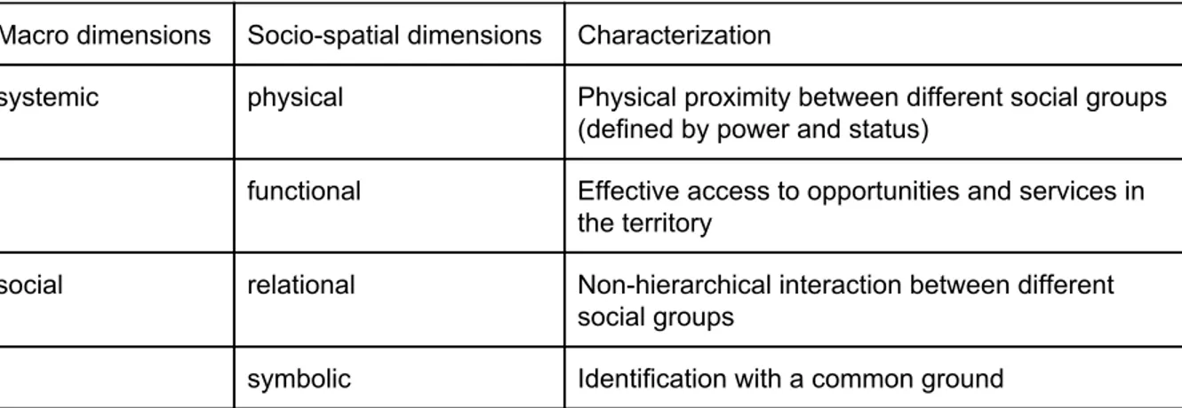
Ruiz-Tagle proposes “a generalized non-exclusionary form of zoning (which would tackle both elite and ghetto segregation), and integrative policies that consider much more than location” (Ruiz-Tagle 2013a, p. 397). He, moreover, suggests a table of socio-spatial integration combining physical and social measures. All socio-spatial dimensions mentioned below should be fulfilled in order to achieve integration. Functional integration into the city might be achieved by enhancing access to public transport, public services, and other commercial and non-commercial facilities; to achieve symbolic and relational integration, strategies should focus on improving the neighbourhood climate and social cohesion within the district and with the remainder of the city; moreover, identification with the district and the city is important; the segregated district must be viewed as a part of the city in order to become an attractive living space. These measures are set to enhance the attractiveness of a neighbourhood and, thus, should lead to social mixing by itself. Although not mentioned in the table below, cleanliness and safety as well as a mix of tenures is crucial to make the neighbourhood liveable.
Table of socio-spatial integration (Ruiz-Tagle 2013a, p. 401)
Macro dimensions Socio-spatial dimensions Characterization
systemic physical Physical proximity between different social groups (defined by power and status)
functional Effective access to opportunities and services in the territory
social relational Non-hierarchical interaction between different social groups
symbolic Identification with a common ground
Andersen distinguishes between three strategic approaches: “(1) Efforts to combat the exclusion of neighbourhoods: initiatives that focus on how to stop and reverse the self-perpetuating processes that make some areas increasingly stigmatised and unattractive compared with the rest of the city. (2) Area-based efforts to combat social exclusion: as a supplement to general welfare policies, it can sometimes be relevant to have efforts concentrated in deprived urban areas for two reasons: to combat the special effects
produced by area deprivation that tend to increase social exclusion; and, because local private resources perhaps could be mobilised to support public efforts. (3) General efforts to combat segregation: initiatives that attack conditions which tend to increase segregation - for example, differences between tenures or rules for the allocation of dwellings in social housing” (Andersen 2000, p. 771). This distinction can also be used to categorise all the aforementioned measures from a public policy point of view.
All in all, there is, hence, no general strategy to successfully integrate segregated city districts or neighbourhoods that could be derived from the academic literature. The appropriate measures depend heavily on the specific characteristics and issues of the district and the city. However, the literature indicates that all the dimensions of segregation must be considered while developing an integration strategy. Since social and spatial mechanisms lead to the segregation of an area, influence, and intensify each other, a socio-spatial integration approach is indicated. It is not enough to only change the physical appearance of a district or trying to fight the local poverty. It is definitely not sufficient or efficient to force social mixing by relocating citizens as this leads to physical but not social proximity between social groups. Instead, comprehensive and long-term socio-spatial integration strategies should be exercised that take the residents into account. Overall, it is important to note that integration is always a relational approach. It is not enough to focus only on change in the segregated neighbourhood or the local population but the city and all of its citizens must be considered. Having, thus, made a theoretical research on the concept of urban segregation and integration as well as on possible governance measures, in the following, it will be looked at how the city administrations of Århus, Malmö, and Mannheim understand the concepts and approach the issue.
3. Methods
Before analysing the case studies, the following chapter elaborates on the research design of the study, the used methods, and the limitations of the research.
3.1. Selection of cases and used methods
In order to find answers to the research aims, that are
How can city administrations integrate socially and spatially segregated mass housing districts in cities with an industrial past? and Why do cities have different integration approaches?
it was decided to conduct a comparative case study. Three cases were chosen that would allow for a variation in policy-design but have otherwise similar characteristics in order to assess possibilities of counter-segregation policies. Thus, a “most similar” design was chosen with cases of the same phenomenon, that is urban segregation of European mass housing districts (cf. George/Bennett 2005, pp. 69/83). To ensure that the cases were analysed in similar depth and width and thus provide comparable data, a set of four questions was developed (cf. research questions in chapter 1; George/Bennett 2005, pp. 67/69).
The cases studies were therefore chosen due to their comparability. Having an initial interest in the case of Rosengård and Malmö, cities with similar characteristics were sought out. A preliminary analysis discovered that the cities of Århus and Mannheim not only have similar characteristics but similar segregated districts and also try to solve the issues present with public policies. A further investigation of the cases showed that the cities share a similar post-industrial history and consist of around 300 000 inhabitants. They all have at least one district that consists of mainly residential high-rise buildings constructed between the 1960s and 1980s which suffers from high unemployment and crime rates as well as a bad public reputation. However, different counter-segregation strategies are pursued that allow for a valuable comparison of the municipal scope of action in that regard.
The cases were then examined based on a content analysis of official documents as well as on in-depth expert interviews with representatives of the respective city administrations. By analysing documents issued by the city administrations, the underlying premises for the strategies as well as the city administrations’ perspectives were to be investigated. In order to get a better insight into the reasoning, it was decided to conduct additional expert interviews. These were also to provide knowledge on how the city administrations perceived the strategies after a couple of years and what they planned for the future. Semi-structured interview guidelines were developed in order to receive comparable data but also to allow for additional information that was not thought about before (cf. Appendix). The interviewees were chosen due to their position in the city administration and their knowledge on the district as well as the strategy. They were then contacted via e-mail and interviewed via telephone (Århus and Mannheim) or in person (Malmö). The interviews were recorded and transcribed (and in the case of Mannheim translated) in order to be able to listen to them again and not miss out on any information.
The knowledge gathered through the interviews as well as the content analysis is presented in this paper. As it is beneficial to have maps as well as pictures to understand the segregation and counter-segregation strategies in the cities, a supplementary website was set up: http://nosegregation.tilda.ws/. The website is able to provide more in-depth information on the districts and illustrates especially the physical appearance and spatial location of the districts. It is moreover used to make linkages to the original city documents available to those who are interested.
3.2. Limitations of the research
This research faces some limitations due to the selection of cases, the choice and conduct of methods, and the overall framing of the research interest. Since only three cases are analysed, this study cannot claim general knowledge on urban segregation or all the possible counter-segregation measures. Although it provides some knowledge on how particular cities deal with a similar issue, this cannot be generalised to answer how the respective countries deal with the issue as a rule. Neither can it provide knowledge on if cities in general, especially cities in other parts of the world than Europe, suffer from segregation or what successful counter-strategies would look like. Moreover, the national settings of the analysed cases were not taken into account, that is for example the scope of
action municipalities have in these countries, or the state of the national economy. However, these are factors that may influence the cities’ decision to deal or not deal with urban segregation as well as their choice of measures.
Moreover, the outcome of the strategies were not a focal point of the study although the actual success of planned measures is a valuable factor in evaluating the approaches. In order to achieve this knowledge it is crucial to conduct the perception of residents of the area as well as making field trips to the districts. This could not be accomplished in the short timeframe. Furthermore, the research would profit from a higher number of interviewees in each case, as especially the analyses of Århus and Mannheim rely heavily on only one source of information in that regard. Overall, it has to be said that this analysis is an interpretation based on official documents and empirical material collected via interviews, that is made from an outsider-perspective, as it is not within the scope of this study to obtain a proper insight by visiting the districts or conducting more ethnographically oriented studies. To gain more knowledge in the matter an ethnographic study could be useful, e.g. a participatory observation or qualitative interviews with participants or organisers of the social initiatives, or possibly a survey with the residents in each respective district. However, the study can give some valuable knowledge on how different cities deal with urban segregation.
4. Presentation of case studies
The following chapter focuses on the description and analysis of the case studies. Firstly, the cases are described, then the counter-segregation approaches are illustrated, and, lastly, the strengths and weaknesses of these approaches are assessed.
4.1. Århus
4.1.1. Århus: description of the case
Århus is Denmark’s second biggest city, with 269 000 inhabitants. It is located on the eastern side of the peninsula Jutland by Århus bay. Århus has been known as settlement since the 10th century but was first formally recognised as a city in 1441. Due to its prime location in terms of maritime trading, the city grew exponentially and was quite an important centre for commerce in the medieval era. Along with the entry of industrialisation in the 19th century the infrastructure developed extensively, namely the road and rail network, as well as the harbour. Today it is Jutlands biggest centre for commerce, service, and industry. The second largest university of Denmark, founded in 1928, is located on a campus just outside of central Århus along with the university hospital (Lykke-Andersen 2017a).
Gellerup is a neighbourhood in Brabrand located on the western border of Århus, covering the neighbourhoods Toveshøj and Gellerupparken. Around 11 000 people currently reside in the area. Toveshøj and Gellerupparken combined are made up of more than 80 nationalities with 86% of the residents having a non-Danish origin. 80% of the population have a refugee- or immigrant background from a non-western country. Compared to the rest of Århus, the young population is relatively large, almost 40% are under 18 years, while in the municipality at large it is only 21%. Half of the residents in Gellerup are outside the official labour market, of which 25% have gone into early retirement and 20% receive welfare subsidies. The
average income is 151 000 DKK/year (Samvirket 2012), which is lower than average in Århus (179 000 DKK/year in 2006; Aarhus Kommune n.d. c).
The district was developed in the early 1970s within the framework of Gellerupplanen (Lykke-Andersen 2017b) as a way to solve the staggering housing crisis (Effekt n.d.). It was planned as an ambitious, prefabricated residential area consisting of smaller and larger housing blocks. The district was meant to function as an infill in between the old city centre of Århus and single-family houses and detached town houses built in the outskirts of the city between 1930 and 1970. The blocks in Gellerup have 4 to 8 storeys and were mostly directed to those who otherwise could not afford a decent home elsewhere (Van Aerschot/Daenzer 2014). The district was planned to enable residents to live their lives within the area, supplying them with various facilities: a library, schools, a swimming pool, and even the largest shopping centre in the whole region (Van Aerschot/Daenzer 2014). Today it is Denmark’s largest solitary modernistic dwelling and referred to as mono-functional, disadvantaged, and as having a general bad reputation (ibid.). Moreover the district has been described as a residential ghetto and is closely associated with high crime rates, socio-economic marginalisation, unemployment, and integration difficulties (Aarhus Kommune n.d. b).
4.1.2. Århus: description of the strategy
The following analysis is primarily based on the empirical data gathered in a telephone interview with Per Frølund on 9 May 2017, the official comprehensive plan for the project (Århus Kommune/Brabrand Boligforening 2007), and other supporting official documents produced and/or published by the city administration. Per Frølund is a programme manager of the Master plan in Gellerup and works in the Mayor’s office.
Why and how did the city administration of Århus plan counter-segregation policies?
When asked about what the district of Gellerup was like before the Master plan was initiated, Frølund explains that it was experienced as closed and isolated. The residents (especially the female residents) would rarely leave the area and the only reason for people from the rest of Århus to visit was the public pool. In the media it was described as a ghetto and criminal incidents were reported nationally, e.g. as a kindergarten was burnt down. The road structure made it difficult to access the area, even by car, as many roads where one-way- streets (interview Frølund).
The Master plan identifies Gellerup as a socially deprived area that they want to make a part of the city by creating “anchors” or “magnets” to not only tie the residents to the area but also invite visitors to a greater extent (Århus Kommune/Brabrand Boligforening 2007, p. 3). The aim is to make Gellerup an urban district and to enable people from different areas to meet and mix (interview Frølund). The municipality’s website on the project refers to research (both domestic and international) that indicates that to divert a negative development of isolation and deprivation, there needs to be a combination of social and structural/physical efforts, where the residents’ educational levels, working life, and income will be positively influenced (Aarhus Kommune n.d. a). Frølund emphasises the importance of having a holistic approach, also comparing this project to other similar projects in Denmark, which have been more one-sided and therefore fractured and not very successful. The key,
according to him, is making structural changes otherwise the more well-off residents will leave the area when they have the possibility to do so (interview Frølund).
The foundational idea of the project is that no urban development project can or should create a forced social mixing. However, in this project they do attempt to make structural changes, which will give all the residents of Århus greater possibilities of meeting and interacting and hopefully break down the barriers between the districts, i.e. physical structural changes combined with social efforts (Århus Kommune/Brabrand Boligforening 2007). Frølund explains that it is important to not settle for one finished plan but to have the political patience to develop the plan over the years. Moreover the plan should start strong so everyone can see that the municipality really means business. The plan has to be developed from there as one cannot do everything in just one big blow. It is not possible to do everything at once as there is not enough funding. Furthermore, it would be a bad idea because the municipality has gotten wiser throughout the process: “We are creating a small city within this district and we are not the only ones who want to develop in the area right now, a lot of people are starting to get involved. However, we cannot create everything. We invite people in and they don’t always do what we want them to do, so we talk about it and find a solution. Creating a small city life is not something you can plan or control, you can simply make a foundation for it. We do not have a recipe for it, but we have done quite well so far. We are definitely not there yet” (interview Frølund).
The project was initiated by Brabrand Boligforening (housing organisation) and the City of Århus, and was funded by the Danish Ministry of Social Affairs. The foundation Landsbyggefonden has set aside 911 million DKK in the form of direct funding and subsidised loans are earmarked for Brabrand boligforening, more specifically for the housing development (SmartAarhus 2015).
How are the concepts of segregation and integration perceived by the city administration of Århus? What are the underlying thoughts and premises?
Gellerup’s mono-functional character and uniform physical expression in combination with the residents lack of connection to the labour market, the low income, and a large number of children without a supporting role model, puts the district at risk of becoming a secluded parallel community to Århus (Århus Kommune/Brabrand Boligforening 2007, p. 5).
The fundamental vision of the project is to create a “unique and diverse part of the city with its completely own character, architectural structure and city life” (Aarhus Kommune n.d. a). The stakeholders aim to develop a new part of the city where social and physical problems of isolation are solved by creating diversity in the city life and the composition of the residents. As the area has been considered segregated it is important to lift the general standards and adapt the rates of education, health, and crime to match the rest of Århus (Aarhus Kommune n.d. a).
When asked whether he would consider the Master plan as an integration strategy, Frølund claims that it is not in the sense of integrating immigrants or newcomers, but it is a way of integrating and connecting the district of Gellerup with Århus, as it has been one of the more
deprived areas in Denmark and has been quite isolated in the past. The concept of integration (in the sense of integrating Gellerup, not immigrants) is very present in the city administration’s day-to-day agenda and Frølund claims that the Mayor talks about it frequently. It is not only important that the residents of Gellerup feel that they have the opportunity to leave, but also that non-residents have an interest in visiting Gellerup, something the “A taste á la Gellerup”-project (“Smag á la Gellerup”) was very successful in achieving. It is a small way of opening the area up mentally. The final vision is that one will not know where one district starts and another stops, it will simply be an uninterrupted flow (interview Frølund).
Frølund himself is primarily involved with the more spatial and physical changes, but talks at length about the importance of the participation of the public. This is highlighted in the Master plan (Århus Kommune/Brabrand Boligforening 2007, p. 4), but in our interview Frølund explains that this is a point where they have struggled slightly: the participation has been less than what they had hoped for, possibly due to the language barriers and lack of interest. Currently they are producing a brochure that will be sent to 50 000 households, informing them about the project, the intentions, and the progress (ibid.).
What measures are planned by the city administration in Århus (and what are the taken measures and their outcomes)?
The following initiatives are all within the framework of the Master plan. The stakeholders and financiers differ slightly between the projects, e.g. most of the housing initiatives are done by the housing organisation, while the city administration is responsible for the public participation efforts, in cooperation with various interest organisations.
There are 319 youth housing units planned, which will be located in close proximity to the main road. Frølund and his colleagues believe that offering housing to students and young people will be the start of a differentiation process of the population. According to him one cannot expect people with an established career and a good financial situation to choose to move to Gellerup now, considering its reputation.
Another effort to achieve a greater diversity of residents, is a greater variety in tenure and housing forms. Many of the pre-existent housing blocks are being renovated and new housing will be built as infill in between the pre-existent blocks in order to attract new socio-economic groups. In addition, the city administration has in cooperation with the housing organisation extended the already existing ‘combined renting’-scheme (Kombineret udlejning). That means that not only empty apartments are being transformed to house other functions, but also that certain social groups are prioritised as long as there is a general demand in the housing market in Gellerup (Århus Kommune/Brabrand Boligforening 2007, p. 14). Moreover, residents that will be relocated due the rebuilding of the area have a sort of ‘safety guarantee’, i.e. they are sure to be offered housing of the same standard, either in the same neighbourhood or in a different part of Århus if they wish (ibid, p. 16).
A phase in the plan that is close to be finished is the restructuring of the road network and opening the area up - also symbolically. An important part of this is the establishing of a new
main road from Bazar Vest (shopping centre) to City Vest. It will serve as a connection of Gellerup with the rest of the city, starting at the border of the western part of Århus and stretching through the heart of Gellerup. The idea is to develop the area along the main road to make the area more vivacious and active. Moreover, a large proportion of the city functions and jobs in the public sector will be situated in close proximity to the main road (Århus Kommune/Brabrand Boligforening 2007, p. 8). Another important aspect in this process is making room in for the light-way tram that will run through the centre of Gellerup and further connect the district with the rest of Århus. The municipality has their financing in place, but is waiting for the funding from the state to be confirmed. The space for the rail has already been included in the new road structure and Frølund is convinced that it will happen (interview Frølund).
Århus, moreover, provides some more socially oriented efforts, that aim at strengthening the residents’ sense of community by offering places where they can meet and mingle, and provide outsiders with a reason to visit the district. Firstly, the local library will be renovated which is another effort that is to activate the main road. Secondly, there are plans for a facility that will work as a common space for all the local associations. Frølund calls it a “union house” (“samlingshus”) (ibid.). It is referred to as functioning as a cultural anchor in the Master plan document (Århus Kommune/Brabrand Boligforening 2007, p. 10). Moreover, to meet the needs of the more ‘active’ residents there will also be a large sport and leisure campus with both sport and culture facilities open to the general public (ibid., p. 7). There are also a number of more temporary projects that aim to create a more positive image of the district and attract more visitors, for example ‘food projects’ where the locals gather to cook and sell food for the visitors to buy - “Smag á la Gellerup” (interview Frølund).
4.1.3. Århus: analysis of the strategy
What are the strengths and weaknesses of the strategy? What are the risks and benefits? Machado Bógus (n.d.) defines segregation as the concentration of a group that is involuntarily and spatially isolated. This separation is caused by social reasons, one of these reasons being poverty. The same logic applies to the case of Gellerup: there is a concentration of the local society’s weaker socio-economic groups, which some have referred to as poor (DR Nyheder), although this is of course a relative term in a global setting. Both Andersen (2016) and Ruiz-Tagle (2013a; 2013b) consider spatial separation to be a central, but not complete, explanation for the causes of segregation. One can argue that Lima’s (2001) reasoning concur with this, since he points to urban form and provision of public transport being determinants of segregation, i.e. a spatial separation is emphasised by distance, or experienced distance, which is in turn enhanced by the lack of (public) transport. According to Frølund, there has been limited accessibility to and from Gellerup, which is further indicated by the choice of investing in a new road structure and the establishing of the light-way tram. In addition, Andersen (2016) suggest that the urban poor tend to concentrate in the least attractive parts of the city, i.e. a modernist mass housing district, like for example Gellerup, and that when it has received a label of stigma, the more wealthy people flee. In the interview with Frølund, he stated that this is something that has occurred in Gellerup and that they are working consciously to make the area more attractive
in order to avoid this. He also stated that he can see a limited access to opportunities and a tendency for the residents not to complain as much as residents in other areas would, or really stand up for themselves. Andersen (2016) determines this as consequences of segregation.
As mentioned previously in this chapter, Frølund as a programme manager, would consider the Master plan as some sort of effort to integrate Gellerup as a district with the rest of Århus. This seems to be in accordance with the theoretical framework presented in this paper: a general view of integration is that it aims at merging or consolidating one area with another. The grand of majority of the authors referred to in the literature overview concur on the importance of a combination of social and spatial/structural efforts: “[...] if we treat just the social causes of poverty, we overlook the intensifying effect of physical concentration. In turn, if we deal only with the spatial enclosure, we would be treating only the intervening variable, not the causes” (Ruiz-Tagle 2013a, p. 392). The Master plan presents efforts of both characters and when asked about the essence of the project, Frølund declares very clearly that the objectives are structural changes in combination with social efforts.
Although some of the measures in Gellerup aim at achieving social mixing and people have to move out during restructuring efforts, the Master plan does not entail a forced relocation of residents as these residents have a guaranteed right to return. However, a bigger variety of housing forms and tenures is to be offered in the future and youth housing estates are built. Thus, the city administration does indeed try to attract other social groups to the area, but has in fact no real expectations that well-off people will move to Gellerup (cf. interview Frølund). The effort of attracting younger people with cultural capital as well as the transformation of tenures can however be seen as a first step towards a planned gentrification of the area.
Segregation is an effect of living preferences, so in order to integrate an area it needs to be made attractive. In practice, this means, according to Andersen (2002), to improve the aesthetics and social attractiveness of the area by e.g. offering good accessibility: in form of public transport, access to the labour market, embellishing of buildings and facades, and access to public services like schools and health care. As mentioned before, there are transport efforts in place in the Master plan for Gellerup. Moreover, the large mass housing blocks are being restructured and the facades renovated to give a more unique and varied impression of the area and to increase the attractiveness of Gellerup. The relocation of 1 000 jobs in the public sector is supposed to create an inflow of people from other parts of Århus, but also to increase the accessibility for the local residents to the labour market. In addition, some of these jobs also involve various public services, which will with then be more accessible to the residents of Gellerup.
Ruiz-Tagle’s (2013a) reasoning on functional integration incorporates similar ideas, but also refers to softer aspects of social cohesion, improving the neighbourhood climate and the identification with the district. These aspects are important to also keep the more well-off residents in the area and thereby avoid a magnification of poverty. He claims that this would lead to social mixing occurring organically, i.e. trying to create a more varied composition of the population in the area. Social mixing is frequently referred to as possible indicator of
integration, both in theory and concrete planning, although the consensus is that it is not the sole solution to integration. According to both Frølund and authors like Young (2000), social mixing cannot and should not be forced. Smets and Salman (2008) identify three categories of strategies, out which one can be used in the context of public policy: namely mixing strategies. This goes in line with the relocation of jobs in the public sector creating an inflow of visitors from other parts of Århus. In the Gellerup project it is hoped to be achieved also by making the area more attractive and thereby appeal to new, socio-economically stronger residents.
In conclusion, the Gellerup Master plan follows the directives of integration by: considering the social as well as the spatial and structural aspects, by highlighting the importance of social mixing but implement efforts that will make it happen naturally, i.e. making the area more attractive for different socio-economic groups, tying the disintegrated district to the rest of Århus by increasing accessibility and by attempting to build uniformity by breaking the area up in smaller neighbourhoods. A possible point of critique is that the project seems to be organised according to a top-down structure. Even though it is stated clearly in the project’s comprehensive plan that the public should be involved - “it is important that a great effort is made to involve the people” (Århus Kommune/Brabrand Boligforening 2007, p. 20) - most of the planning and implementation takes place without any involvement of the residents. According to Frølund it is true that efforts have been made, but that the involvement of the public has been one of the greatest struggles in the project. He states that only few residents turn up to most events and meetings and that these are usually the same 100 to 150 people. Moreover, the city administration had expected more discontent with the project, which could indicate a lack of engagement within the neighbourhood. A possible reason for this is that Gellerup being a segregated area means that the residents do not identify with or feel as invested as residents in other districts .1
4.2. Malmö
4.2.1. Malmö: description of the case
Malmö is a city with around 300 000 inhabitants, located in the southern part of Sweden. For a long period in the 20th century the city was an industrial hub and an important port. When the industries collapsed in the 1990s, it was decided to change the image of Malmö, to use a creative niche and make it innovation-based. Therefore the university was created along with the new districts of Western Harbour and Hyllie. From the early 2000s on, the city is connected with Copenhagen by the bridge and is perceived as a part of the greater Öresund region.
During the industrial past of the city, there was a deficit of decent housing for workers, so the district of Rosengård was created in the outskirts of the city as a part of the Swedish Million homes programme (Hall/Vidén 2006). The district was created on the principles of modernism, i.e. high rise mono-use housing buildings with unified and simple facades, a lot of green space between dwellings, and wide roads aiming at car usage rather than other
modes of transport. Moreover, the district was planned to be a ‘city in the city’, so that it had its own centre with the shopping mall, a hospital, a library, schools and so on. At the beginning perceived as modern and comfortable housing, with the passing of time, Rosengård has faced decay. As the initial residents were leaving the area if they got an opportunity, the area was losing its prestige (Parker/Madureira 2016). Therefore the vacant apartments were occupied by less wealthy residents, many with a migration background. At the same time stigmatisation and segregation processes in the area became very clear, so the municipality initiated several projects to overcome these problems.
It is vital to have counter-segregation measures as the district of Rosengård is hard to ignore on the city scale: it has 23 600 inhabitants and occupies 332 hectares, what makes it one of the city’s largest neighbourhoods. The young population is rather large in the area: 16% of the population is between 16 and 24 years old. The average disposable income amounts to about 132 000 SEK/year, which is lower than average in Malmö. According to Listerborn (2007), Rosengård is not homogeneous - there are different types of housing, mostly high-rise buildings, but also relatively well-off villa areas. The population is also very diverse - 60% of the inhabitants are born abroad and 88% have a migration background. Thus, today the area is facing several challenges, that is very high levels of unemployment, low income levels, a low percentage of people with a higher education and high levels of child poverty (Parker/Madureira 2016).
4.2.2. Malmö: description of the strategy
The analysis presented here is based on the Comprehensive plan of Malmö (“Översiktsplan för Malmö 2014”) and other official documents of Malmö stad. Moreover it is based on two interviews with Malmö stad employees: Magdalena Alevrá, an architect in the planning office, who has been working with Rosengård for many years, and Jonna Sandin Larkander, who is an employee at the strategic department. Alevrá was interviewed on 12 May 2017, Sandin Larkander was interviewed on 9 May 2017. The analysis stems also from secondary data from the articles of Parker and Madureira (2016) as well as Listerborn (2007).
In an attempt to cope with the stigmatisation, the municipality has taken action in diverse directions in cooperation with housing and public transport companies, local actors, and private firms. However, there is not a general overarching plan for redevelopment. According to one of the respondents, this was a result of limited financial means, as the city of Malmö does not receive the financial support from independent funds like e.g. the Danish case presented in the previous section. Therefore different strategies implemented in the area will be analysed below. Not all of them are proclaimed to be unifying the area with the rest of Malmö, but if they have promoted integration of the district, they have been included in the research.
Why and how did the city administration of Malmö plan counter-segregation policies?
Malmö is characterised by a geographical proximity between neighbourhoods of different character, but at the same time it has many significant barriers that make the differences between the neighbourhoods visible. These barriers sometimes also reinforce mental lines