To Handle Space
- A qualitative study of traffic planner´s experiences of planning for
pedestrians and cyclists in complex urban settings
Author: Martin Forsberg
Master Thesis in Built Environment (15 credits) Tutor: Göran Ewald
2
Title: To Handle Space - A qualitative study of traffic planner´s experiences of planning for
pedestrians and cyclists in a complex urban setting
Author: Martin Forsberg
Master Thesis in Built Environment (15 credits) Tutor: Göran Ewald
Spring Semester 2013
Sustainable Urban Management Examinator:
Summary
This thesis investigates five traffic planner´s experiences of planning for pedestrians and cyclists in complex urban settings. Three themes, or relations are investigated: priority or hierarchy; separation or conglomeration; and top-down design or bottom-desires. The research was conducted through qualitative interviews to get hold of traffic planner´s experiences and understandings of how to understand space. Firstly, the results show that the traffic planner´s experience that the car still is the norm in the traffic system, but that re-prioritization of space to make pedestrians and cyclists the norm is getting more widely accepted. Secondly, there is a spread understanding that separation of uses and functions are to prefer before creation of shared spaces. Shared spaces are seen to neglect accessibility and separated spaces with overlapping functions are seen to clarify uses. Thirdly, it is meant that it needs to be a mutual relationship between top-down design and bottom-up desires to create space that meet different needs; a purely top-down approach will miss preferable uses of an existing place, and a purely bottom-up approach is understood as a possible hindrance to get things done.
3
Contents
1.0 Introduction 4
1.1 The Urban Space 4
1.2 The People and “Green” Mobility 4
1.3 The Aim of the Study 6
1.4. Problem Statement and Research Questions 6
1.5 Previous Research 7
1.6 Acknowledgements 8
1.7 Disposition 8
2.0 Method 9
2.1 Collection and Conduction of Qualitative Data 9
2.2 Participants 10
2.3 The Researcher´s Role, Ethical Standpoint and Thesis Boundaries 11
3.0 Theoretical Background 12
3.1 Territorial Relationships and Power 12
3.2 Organizing Space 14
3.3 The Creation of Space 15
3.4 The Official Standpoint 17
3.5 The Author´s Summary and Reflection on the Theory 18
4.0 Analysis 20
4.1 Presentation of Object of Study 20
4.2 Priorities and Hierarchies in Space 20
4.3 Separation and Conglomeration of Functions 21
4.4 Top-down Design and Bottom-up Desires 23
4.5 Summary Analysis 25
5.0 Conclusion and Discussion 27
5.1 Priority or Hierarchy 27
5.2 Separation or Conglomeration 28
5.3 Top-down Design or Bottom-up Desire 30
5.4 The Author´s Reflections 32
References 34
Appendix 36
4
1.0 Introduction
1.1 The Urban Space
The City is man's most consistent and on the whole, his most successful attempt to remake the world he lives in more after his heart's desire. But, if the city is the world which man created, it is the world in which he is henceforth condemned to live (Park, 1967, in Harvey 2003, p.1)
Jan Gehl (2010) means that cities today face countless challenges, for example “limited space, obstacles, noise, pollution, risk of accident” (Gehl 2010, p.3). Connected to rapid urbanization, and intensified pressure on urban spaces, the need to meet a wide range of interests and desires are a major challenge for city planners.
Paul Jenkins et al. (2005) claim that the development, planning and management of cities have taken many developments and forms throughout history. It is argued that specialization of space and differentiation of uses in space are strongly connected to the fact that most societies have, and still are becoming more and more socially and economically specialized and differentiated (Jenkins et al., 2007).
The increase of uses and needs in urban settings foster many challenges: challenges that in the light of sustainable development (WCED, 1987) generates pressure on urban planning and development to both create a city that meets several needs and at the same time, to create a city that is sustainable. Gehl (2010, p.6) claims that both new and existing cities are standing before the need of making “crucial changes” in planning and prioritization and to have a clearer and better focus on the people´s needs in the city, and as Harvey (2003) claims: it is not possible to separate what kind of city we want to have and “what kind of people we want to be” (Harvey 2003, p.1).
In 1938, Lewis Mumford claimed that “The City” is the place where “the diffused rays of many separate beams of life fall into focus” and that the city is symbolized of integrated social relationships where “human experience is transformed into viable signs, symbols, patterns of conduct, [and] systems of order” (Mumford 1938, p.19). He continues with some questions that are as adequate today, as they seemed to be back in 1938 as he wonders: “have we yet found an adequate urban form to harness all the complex technical and social forces in our civilization; and if a new order is discernible, what are its main outlines” (Mumford 1938, p.22). Now, almost 80 years later, these questions are still central as urbanization puts a high pressure on environmental, social, economic and technical systems.
1.2 The People and “Green” Mobility
In the midst of different urban development approaches are humans with their needs, desires, hopes and dreams. There are undoubtedly a plentitude of needs and desire in an urban setting, but one central aspect is the possibility to be mobile. To be mobile is a freedom that enables
5 people to commute to and from work, it allows people to enjoy the city and its surroundings, movement also enables people to meet, and it creates flows of goods which is vital for the survival of businesses. Mobility can also have recreational aims, and be a means of exercising, etc. There are many ways to be mobile in urban landscapes today as people can travel by light-rail, tram, bus, car, motorcycle, moped or other motorized vehicles; people can also move around by bike, skateboard, Segway, in-lines, or simply by walking.
To have a larger and larger population living together on denser and denser space, makes it important to plan for which kinds of travel modes that should be central in the mobility system. The different kinds of mobility and the relationships between people in public places make up a complex system of different networks, co-existing and/or conflicting with each other, Sheila Foster (2011) underline the importance to control urban commons to avoid problems of conflicts, rivalry and congestion; Richard Little (2005) emphasizes the need for modern economies and modern societies to have well-functioning infrastructural systems.
For many cities, the aim of being “lively, safe, sustainable and healthy” has become “general and urgent”, so by promoting pedestrians, cyclists and city life in general, these aims can be greatly supported and perhaps reached (Gehl 2010, p.6). A city aiming to be sustainable needs a large part of “green” mobility as it is claimed that pedestrianism and cycling foster both economic and environmental benefits as they decrease the consumption of resources, they limit emissions, and they lower noise pollution, etc. (Gehl, 2010).
As many cities has developed around the car and its need of vast spaces (Gehl, 2010), a central aspect in redeveloping cities is which priority “green” travel modes will get when space for mobility is refurbished to promote pedestrians and cyclists. As different travel modes needs different amount of space, different infrastructural “language” and that different travel modes moves in different speed, an understanding of priorities is closely connected to an understanding of hierarchies and relationships between travel modes. Who has the right to existing space? How should urban space be organized to meet different needs of mobility?
In the city of Malmö, where the research was conducted, the municipality has clear visions to make Malmö a more sustainable, attractive and safe city, and a central part in this is long-term investments in a sustainable transport system. A sustainable transport system is said to consist mainly of people that travel by foot, bike or by public transport as these modes does not only contribute to get better air quality, decreased climate effects and more effective use of energy, they also contribute to less noise pollution, better physical and mental health, increased equality, increased safety, more meetings between people, higher quality of life, etc. (Malmö Stad, 2012c).
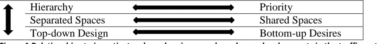
When redeveloping an existing area, with the aim to distribute more space to pedestrians and cyclists, there are many aspects that need consideration. What are the current hierarchies? What should be prioritized in the new area? What uses and functions should exist in the area? Should functions and uses be separated or mixed? Should the new area be designed with a top-down approach or should the existing movements and uses decide the refurbishment? Figure 1 clarifies these relations.
6
Hierarchy Priority
Separated Spaces Shared Spaces
Top-down Design Bottom-up Desires
Figure 1 Relationships to investigate when planning complex urban redevelopments in the traffic system
Figure 1 shows different relationships that are central to investigate and discuss when planning to redevelop an existing area. The relationships can be understood separately or as a process.
First it is vital to investigate the current hierarchy1 and priority2 of functions and uses in the existing area; then to clarify the visions of the area under redevelopment, as new priorities might change existing hierarchies. Are there new functions that are planned to be prioritized? How will that affect the current hierarchy? The relationship between what is said to be prioritized and how the actual hierarchy looks are vital aspects in the understanding of relationships in the traffic system.
The second relationship to investigate is if planned functions for an area should be separated or if different functions can exist in the same space? If functions are going to co-exist, how should space be organized so that different functions and needs can operate side by side?
The third relationship is how an area will be created, should space be created with a top-down design approach, where the design of a place affects use, or should space be redeveloped and decided through looking at existing patterns of movement, uses, and needs?
1.3 The Aim of the Study
The aim of this study is to investigate aspects of urban traffic planning that can be vital in the development of a sustainable traffic system with a focus on the understanding, organization and creation of space for pedestrians and cyclists. Traffic planning is analyzed and discussed via three themes: priority or hierarchy; separation or conglomeration; and top-down design or bottom-up desires.
1.4. Problem Statement and Research Questions
In the aim of being a more sustainable city, the need to promote “green mobility” is a vital piece in the urban puzzle. And with urbanization and aims of densification there are many vital decisions to be made when it comes to functions and uses.
1
Hierarchy: “a system in which members of an organization or society are ranked according to relative status or authority” (Oxford Dictionary [online], 2013)
2 Priority: “the fact or condition of being regarded or treated as more important than others” (Oxford
7 The following questions will be analyzed and discussed to get a wider understanding of tasks traffic planners face when planning to redevelop space for pedestrians and cyclists:
- Who is prioritized and who is not? - To separate or to conglomerate? - Who is designing for whom?
1.5 Previous Research
A lot of research has been conducted on, or connected to, urban structures, urban planning, urban design, city planning, traffic planning etc. The following articles give a good understanding of the subject in this thesis.
Firstly, Jane Jacobs the Death and Life of Great American Cities (1961) is an important cornerstone in all urban research as it thoroughly and in a common language describes urban conditions. Jan Gehl (2010) The Life between Buildings also gives a description of urban conditions in a wide and easy going way as he presents many different aspects and ideas on how to plan and create a city with a high quality of life.
Environmental Psychology by James A. Russell and Lawrence M. Ward (1982) provides a deep understanding on environmental psychology, which is a branch of psychology that provides a systematic description of the relationship between person and environment. Russell and Ward (1982) mean, for example, that human behaviors occurring in one place would be out of place elsewhere, which tells us that place causes, or elicit behavior. It is also claimed that different people arriving to the same place starts acting similar or same, which emphasizes the place-specificity of behavior. That, and how, place causes behavior is of course central when planning urban spaces.
Continuing, Mattias Kärrholms articles The Materiality of Territorial Production (2007) and The Scaling of Sustainable Urban Form (2011) provides two important perspectives on urban planning. Kärrholm (2007) brings together research on territoriality and actor-network theory to develop new understanding of the role of material design and territorial power relations by presenting different territorial productions (strategies, tactics, appropriations and associations). Kärrholm (2011) investigates issues of scale and “spatial scale”, firstly by discussing the concepts and problems of spatial scale, secondly by discussing discourses of sustainable urban forms, and lastly investigating plans and projects in the urban development of Malmö through the three categories: territory, size, and hierarchy; vital perspectives when discussing urban development. The articles of Kärrholm provide interesting frameworks for understanding urban relationships.
The concept of Desire Lines, Erika Luckert (2013) Drawings We Have Lived: Mapping Desire Lines in Edmonton and James A. Throgmorton and Barbara Eckstein´s article Desire Lines: The Chicago Area Transportation Study and the Paradox of Self in Post-War America (2000) provide a good understanding of the concept desire lines. Luckert (2013, p.318) describes desire lines as “a means of expediency”, and the planners of the Chicago Area
8 Transportation Study (CATS) describes desire lines as “the shortest line between origin and destination” which shows how a person would like to move, if such a way were available (Throgmorton & Eckstein, 2000).
Articles that more practically discuss aspects of urban planning are first an article of Ben Hamilton-Baillie Shared Space: Reconciling People, Places and Traffic (2008) which discuss the approach of shared space in traffic planning. Shared space aims to reconcile the relationship between traffic and the public and is investigated through aspects such as street design, traffic flow, road safety, behaviors, etc. Also Simon Moody and Steve Melia, in their article Shared Space – Implications of Recent Research for Transport Policy (2011) and Allan Quimby and James Castle (2006) a Review of Simplified Streetscape Schemes presents a wide range of examples of shared spaces, hence, with more a practical approach than the approach in this thesis.
Some official documents that are central to urban planning in Malmö are, for example, the program on traffic safety (Malmö Stad 2008) on biking (Malmö Stad 2012a) on pedestrianism (Malmö Stad 2012b) and the program on traffic environment (Malmö Stad 2012c). These documents gives an understanding of the local context and conditions, which can be interesting for anyone interested in urban development with a focus on mobility.
1.6 Acknowledgements
Not a traffic planner myself, with technical knowledge of engineering or architecture, I might be discussing fields in which I might not know a lot about. Despite this, possible lack of knowledge, I believe that there are many important aspects not only connected to technical solutions, but rather aspects built on human understanding, use, feelings and emotions, that is vital in planning a sustainable city.
1.7 Disposition
This thesis consists of five chapters. The first one is Introduction, including background, aim of the study, problem statement and research questions. The second chapter is Method, which explains how the research was conducted. The third chapter is Theoretical Background, where the theoretical framework is presented. The fourth chapter, Analysis, is where the results or the interviewee´s experiences are presented. The fifth chapter, Conclusion and Discussion is where the results are discussed and the researcher´s reflections are presented. The five chapters are followed by References and Appendix.
9
2.0 Method
2.1 Collection and Conduction of Qualitative Data
The qualitative research interview seeks qualitative knowledge expressed in normal prose; it does not aim for quantification. The goal of qualitative research is to gain nuanced descriptions of different qualitative aspects of the interviewee´s world; it works with words, not with numbers (Kvale & Brinkmann 2009, p.46-47, authors´ translation).
The quote above captures what qualitative research aims to grasp. Donald Polkinghorne (2005) means that qualitative data can “serve as evidence” for human experiences and descriptions rather as data that can be quantified and measured. The qualitative and primary data in this thesis consists of written language generated through oral interviews, which through transcription has been transformed into texts. The evidence the texts are, consists not of the “marks on the paper” but rather the interviewees expressed ideas and thoughts (Polkinghorne 2005, p.137-138).
The text-data, or as Polkinghorne (2005, p.138) puts it: “languaged data”, consists of complex and interconnected relations built on words combined into sentences which are combined into discourses. The complexity and interconnectedness is exactly what qualitative research clench after as qualitative research is about collecting “intense, full, and saturated descriptions of the experience under investigation” (Polkinghorne 2005, p.139). Anna Johansson (2005) claims that when using discourses or “stories” in research, the researcher interprets and analyses by examining what is expressed; where every “story” is open for a plentitude of interpretations (Johansson 2005, p.27).
Steinar Kvale and Svend Brinkmann (2009) means that the role of the researcher can be understood through two metaphors; as a prospector of ore, or as a traveler. A prospector of ore sees knowledge to be “buried” inside the interviewee and that it is the task of the researcher, or the prospector, to dig up lumps of knowledge. The metaphor of the traveler can be understood as that the researcher is on a journey in a distant land with the aim of telling a story upon the return home. The traveler moves around, in unknown territory or with a map, asking questions, encouraging the people along the journey to tell their stories (Kvale & Brinkmann 2009, p.64). In the situation of an interview the metaphors also describe different techniques. The prospector of ore sees the interview as an opportunity for the collection of data, separated from the coming analysis. The traveler understands the interview and analysis as two intertwined processes of the creation of knowledge (Kvale & Brinkmann 2009, p.65).
Polkinghorne (2005, p.142) claims that the researcher usually has created questions or protocols3 beforehand as the researcher in advance already knows which experiences that are under investigation and which the researcher wants the participants to describe. The protocol used in this thesiswas sent to the interviewees in advance so that they would be prepared for the questions and themes under investigation. Despite that all of the interviewees got the same
3
10 protocol, the questions and the discussions varied and were somehow adjusted to each interview. An interview session can be seen as a “co-creation” as the researcher´s mere presence and involvement affects the interviewed. Despite that and/or how the researcher affects the interviewee, it is the interviewee who is “the author of the description” (Polkinghorne 2005, p.143).
The five interviews, more or less 60 minute each, were conducted between the 19th and the 29th of April 2013. All the interviews were audio recorded without any complaints from the participants. The interviews were conducted in, or close to, the interviewees working space; a space where the interviewed feel comfortable makes it easier for the interviewer to open up for discussions and to talk more freely and what could have been the case in an unknown environment (Polkinghorne, 2005).
The interviews were transcribed, and then read and categorized to sort out the most common categories and themes. When the categories were decided another round of reading the transcriptions began to check that everything said about the categories were captured. The next step was to find quotes, which are also used in the analysis, in each theme that describes and/or underlines similar or different understandings and experiences.
In the transformation of oral language into text-data the “information and nuance”, the pacing, intonation and emphasis of the oral language are lost (Polkinghorne 2005, p.139, 142). As mentioned, first the recorded interviews were transcribed and categorized, and the selected quotes were translated from my mother tongue Swedish, into English.
In this research, I as a researcher have been a traveler in unknown territory trying to get a hold of understandings and experiences of the interviewees. During this journey, “a map”, or a protocol with questions and themes worked as a guideline both for me as a researcher and for the participants. This approach can be seen, as Johansson (2005) presents it, as a ”shared understanding-model”; a semi-structured interview following a guide, or in this case a protocol (rather than a fixed questionnaire) that gives the interviewee a certain degree of freedom in answering. This approach means that the interviewer has few assumptions beforehand; the interview aims to clarify through questions and tentative interpretations where the interviewer tries not to disturb, confuse or to create contradictions for the interviewed; with the goal to receive a nuanced and describing material that reflects the interviewee´s experiences. Possible critique to this methodological approach is that it can be seen to be unscientific, unsystematic and/or “soft” (Johansson, 2005).
2.2 Participants
As the goal of qualitative research is to get rich and fruitful understandings of a subject or experience, it is important to interview people that share clear and refined understandings. In this study five traffic planners, three working in the municipality, and two working for privately owned consulting companies, are the empirical population of the study.
The participants are a selection not “random or left to choice” but rather a purposive selection of people that would help me as a researcher to “substantially learn about the experience” (Polkinghorne 2005, p.140). It is also important to pinpoint that it is not the persons themselves that are under investigation, but the experiences that they provide
11 (Polkinghorne 2005). And because of this, the interviewed persons in this thesis have been given fictive names.
2.3 The Researcher´s Role, Ethical Standpoint and Thesis Boundaries
The validity and trustworthiness of qualitative research is dependent on the participants sharing of rich descriptions of what is researched. David Silverman (2010) means that validity means truth, and more precise the amount of truth between what is investigated and how it is presented (Silverman, 2010).
Reliability is connected to the possibility to repeat and apply the same study; as the protocol with questions and themes is in the appendix, and the participants are known to be traffic planners the level of reliability in the study can be seen to be good (Silverman, 2010).
As I have a background, and an interest, in traffic related issues a possibility of bias could affect the interpretations of the interviewee’s experiences. This thesis does have a descriptive approach, so there is no intention to hold on to a certain standpoint or to give someone or a specific experience an advantage or a disadvantage. Nor do I have the ambition of discussing my own opinions as the focus in this thesis is the experiences of the interviewed traffic planners.
This thesis will not focus on aspects of car traffic, public transport, freight, logistics, or emergency traffic. But as pedestrian and cycling traffic are parts of the traffic system that includes all this kinds of travel modes a full separation is not possible; other modes than only pedestrian and cycling will therefore be mentioned, even though they are not the main focus. A local traffic system is also connected to the larger regional and national (and international) mobility systems, but the focus here is none the less existing complex urban places in cities and the understanding of pedestrian and biking planning with a focus on priority or hierarchy; separation or sharing; and top-down design or bottom-up desires.
12
3.0 Theoretical Background
In this part the theoretical background and framework of the thesis is presented. This chapter is divided into the themes: Territorial Relationships and Power; Organizing Space; The Creation of Space; and The Official Standpoint. The chapter ends with a short summary and reflection on the theories.
3.1 Territorial Relationships and Power
The relationship between people and the use of public space is vital and can be understood in one way as environmental psychology, as presented by Russell and Ward (1982). They mean that each place, depending on perception, can be defined “whom it belongs to, who belongs there, and who does not” (Russell & Ward 1982, p.675). Another perspective on people and place is the phenomenological perspective presented by Heath Priston (n.d.) which means that “the self and the other are mutually created as entities through a relational process”, a relatedness characterized as spatial (Priston n.d., p.5-6).
Clearly, people and place have a close relationship, and Kärrholm (2007) deepens this understanding or rather the territorial “productions” occurring in places via his categories: territorial strategies, territorial tactics, territorial appropriations and territorial associations.
Territorial strategies, according to Kärrholm (2007, p.441), can be understand as impersonal and planned “at a distance in time and/or space from the territory”, the strategies also allocates control to “things, rules, and so forth”. This perspective can be seen as the plans, or intended use planned to occur in a place. Territorial tactics, on the other hand is more often connected to that people aim to mark and claim an area as theirs, tactics that are happening in “the midst of a situation” as a part of everyday life.
Kärrholm (2007) continues his categories of territorial productions and means that Territorial appropriations are created in an area through “repetitive and consistent use” by people that perceive an area as theirs, but territorial associations, on the other hand, are perceived to be connected to a certain function or to a specific category of people without necessarily being seen by a certain group of people as “theirs” (Kärrholm 2007, p.441). It is vital to understand that different territorial productions usually co-exists and operates at the same place (ibid).
So, there can be a strategy for a place, but the people in a place might have other “tactics”, and people can also appropriate place as “theirs”, which eventually will make a place associated with certain uses, which maybe have not been fully planned for. A strategy not clear or regulated enough might make people impose their own tactics, which might lead to certain appropriations and possible “misuse” with conflicts as possible outcomes. And if an area is associated with conflicts, people might start avoiding that certain place, or at least start using the area in ways less associated with conflicts and rivalry. If people feel ease or unease in one place might affect their behavior in another place, and as flows of pedestrians and
13 cyclists travel through different places the feeling of one place might affect the feeling of another (Kärrholm 2011, p.97).
Russell and Ward (1982, p.666) adds the perspective of speed of movement in the relationship between people and place as they mean that movement let people focus on distant features and gives them the perception of being in a “more superordinate” place.
Flow of people, no matter the travel mode, creates meetings and relationships between people and in an urban environment there are a wide range of relationships connected to priority and hierarchy, and hence power. Manuel Castells (2009, p.10) claims that “power is the most fundamental process in society, since society is defined around values and institutions, and what is valued and institutionalized is defined by power relationships”. So, how different aspects of traffic planning, for example priorities and hierarchies, are valued and institutionalized is clearly connected to power relationships.
It is claimed that dominant social structures “originate from the processes of the production and appropriation of value”, which implies that “value is what the dominant institutions of society decide it is” (Castells 2009, p.27). So, what is valued is also prioritized, and therefore what is prioritized will certainly get a high or higher position in a hierarchy.
A hierarchy consists of asymmetric relationships, as in contrast to a relationship where influence is always reciprocal, or mutual, is that there is “always a greater degree of influence of one actor over the other” in an asymmetrical relationship. Castells (2009) also points out that there is no such thing as absolute power or a zero degree influence of “those subjected to power vis-á-vis those in power positions” as some level of resistance and questioning of a power relationship always is possible (Castells 2009, p.11). Kärrholm (2007, p.443) also mention power relations as he claims that they do not need to be understood along a spectrum of “power at one end to freedom/resistance at the other” or by looking at level of resistance, but instead to ask the question: “how does this place function?” A question that is vital in the understanding of priority and hierarchy in urban traffic systems, but in a re-development, it is also central to ask: “how do we want this place to function?”
Castells (2009, p.11) further discuss power relationships by meaning that there is always “a certain degree of compliance and acceptance by those subjected to power”, and power relationships are not transformed until “resistance and rejection become significantly stronger than compliance and acceptance”. To be able to transform existing power structures it is meant that alternative discourses must be produced; alternatives that have the “potential to overwhelm the disciplinary discourse capacity”, or in other words: the existing discourses and structures. When a transformation eventually takes place those with power loses it and a process of institutional and structural change takes place; the degree of change depends on the “extent of the transformation of power relationships” (Castells 2009, p.16). This change can be understood as a process, where institutional and structural transformations changes through phases.
Castells (2009, p.13) also claims that the “empowerment of social actors cannot be separated from their empowerment against other social actors”, which implies that in a power relationship there will always be a certain degree of asymmetry. In traffic systems, which consist of many possible ways to be mobile, the preconditions are very different between, for example, a pedestrian and a cyclist. When talking about priorities and hierarchies in the traffic
14 system, and a possible re-prioritization, the need to look at power relationships are crucial as priorities and hierarchies affect the relations between travel modes and uses.
3.2 Organizing Space
In an urban setting, a wide range of territorial productions generates a territorial complexity (Kärrholm, 2007) built on a multitude of interests, uses, priorities and hierarchies: so how should space be organized so different uses can co-exist?
Kärrholm (2007, p.446) claim that public space commonly has been seen as a space that holds the co-presence of strangers with a common focus that space is “accessible for all”. But for a place to be accessible to all, or at least a vast range of people, a wide range of activities are also needed. A complex urban space holds different, cooperating, competing regulations, strategies, and productions on several different levels and with different interests. It is claimed that places can be open for all, but only accessible for some, and this accessibility is connected to restrictions on who is “allowed” in a certain place (ibid). So, how should place be organized to be accessible for all? Should it be a place where everyone is allowed, or should it be clear what kinds of uses that are planned and intended in that certain space or area? And how does complexity affect the outcome of organizing space?
Priston (n.d.) means that heterogeneity of uses should not be the focus, but instead how to overlap uses. Kärrholm (2007) continues on this perspective as he claim that conflicts in complex areas are possibly more connected to “tendencies of territorial homogenization or hierarchization”, than to complexity itself (Kärrholm 2007, p.448). He continues by meaning that to make a place more accessible, or more public, is not equaled with the erasing of boundaries; access to space is about providing and meeting different needs and uses, so the differentiation of space for different uses might fetch a “greater degree of accessibility”, but for a differentiation to work, and to create space where people can act and co-act there is a need of “spatial rules and conventions” (ibid). Spatial rules and conventions can be understood as the planned strategy of a place, a strategy aiming at deciding the preferred use and functions.
One way to divide and classify areas is to work with the infrastructural language, and Gehl (2010) means that clear physical demarcations support social structures to be secure and easy to follow as markings, details and artifacts clarify structures. This perspective is underlined by Kärrholm (2007) who means that “knowing how to behave on both sides of a pavement curb could be a matter of life and death” (Kärrholm 2007, p.442).
Further, Gehl (2010) emphasize the human dimension in designing street types and traffic solutions as people that move, by foot or by bike, needs to feel comfortable and safe. Priston (n.d.) proposes that public spaces should take great consideration to people´s experiences of a place to allow for contact between citizens. But if the space is divided into different functions, how will people meet each other? If everyone shares space, will that create more meetings?
It is meant that “shared space” derives from the idea that risk of serious accidents, according to statistics, can be reduced by “physically mixing types of traffic in the same street” (Gehl 2010, p.93). Shared space is built on the presumptions that all travel modes are given the “opportunity to travel quietly, side by side and with good eye contact” and that
15 especially pedestrians and cyclists will be extra “vigilant” (ibid). Shared space can also be seen as a mean to reconcile and integrate the relationship between the traffic and the public, without losing aspects of safety, mobility and accessibility. The idea of shared space is firstly said to be a safety issue, but is also linked to decrease the car-dependency, to increase inclusion and participation, and improve the quality of streets concerning the “ability to cope with movement” (Hamilton-Baillie 2008, p. 163-164).
The dark side of the shared space approach is said to be that in terms of “dignity and quality” the price is high, as shared spaces will affect the possibility of free rein for children and that elder and people with different disabilities might have trouble moving around (Gehl 2010, p.93). It is, thus, mentioned that mixing different traffic modes is possible if pedestrians are the prioritized4, if not it won´t be possible to create space built on equal terms, and in that sense proper separation of traffic modes is preferred (Gehl, 2010).
It is clear that space can be organized in many ways, it is also understood that to organize space for many different functions is a major challenge for urban planners, not at least when it comes to different needs of mobility.
3.3 The Creation of Space
When redeveloping a place, from which starting point is place created? Is an existing urban place seen as a blank page “waiting to be written on” or is it seen as some kind of “palimpsests”5
(Lefebvre 1991, in Kärrholm 2007, p.441)? Is place redeveloped from a distance, through a strategy, or is redevelopment of a place based on territorial tactics and how people appropriate and associate to a place?
It is claimed that places elicit, or cause certain behavior as different people arrive to the same place starts behaving in the same or in similar ways (Russell & Ward, 1982) which implies that the place “decides” behaviors. If the design of place decides behavior, does behavior decide design of place? Or is it a mutual relationship where design and desire form each other?
Kärrholm (2011, p.98) problematize the relationship between urban form and use further as he claims that “the problem echoes the old modernist dilemma of function and form” and “cause and effect”. This implies that the physical design, artifacts, forms and shapes in an urban area produce a wide range of perceptions of place, as they affect the human behavior. Further understood: the relationship between space, or material design and use via territorial divisions, classifications and regulations affects “both explicitly and in more obscure ways” the daily activities and movements of people in a urban setting (Kärrholm 2007, p.440).
4
Examples of Shared Spaces: “the British “home zones”, Dutch “wonnerfs”, and Scandinavian “sivegader” are all examples of successful shared spaces where pedestrians are prioritized (Gehl, 2010).
5
Palimpsests: “a manuscript or piece of writing material on which later writing has been superimposed on effaced earlier writing. Something reused or altered but still bearing visible traces of its earlier form” (Oxford Dictionary [online], 2013).
16 Priston (n.d.) mention Rob Shields (1996) who claims that “circulation of bodies in public spaces” is the basic form of urban sociality as it “provides a vital component in the construction of the public sphere” and that possible circulation is central for a city to be “alive” (Priston n.d., p.3, 8). This hints that how people use a place, through tactics and appropriations, foster both a measurement and a sense of how place is used.
Gehl (2010) claims that good design or layout of the city makes it, without hesitation or detouring, easy and clear for people to find their way around; clear, distinctive and visual characteristics in space, distinguish one area from another. Further, Gehl (2010, p.33) argues that the natural starting point in city design should be the “human mobility and the human senses” as they are the root of human “activities, behavior, and communication”. Also Kärrholm (2007, p.440) claim that the focus should be “territoriality in actu”, or in other words how real life territorial productions are created, rather than the territorial intentions or strategies. What territorial tactics are there? Which appropriations and associations are connected to a place? What uses, needs, behavior, movements and desires exists in urban space?
Throgmorton and Eckstein (2000) mean that in 1955, the City of Chicago in collaboration with three other governmental agencies, created the Chicago Area Transportation Study (CATS). A study with the task of planning the future transportation system for the Chicago metropolitan area, and when finished, delivered influential ideas on future urban transportation studies; one perspective was Desire Lines. The planners of CATS describes a desire line as: “the desire line is the shortest line between origin and destination, and expresses the way a person would like to go, if such a way were available (Throgmorton & Eckstein, 2000).
Luckert (2013, p.318) describes desire lines as “a means of expediency” as desire lines aim to find the shortest or most convenient distance between point A and point B by, for example, cutting corners or crossing where it is most convenient. Desire lines are usually spotted on grassy areas and in parks as marks which show people´s preferred movement. Desire lines do also occur on paved areas, but the marks are not as easily seen as the footpaths do not leave prints after them, but this does not mean that “habitual paths don’t exist” (Luckert 2013, p.324). Luckert (2013, p.323) continues by discussing movements of pedestrians with those of a car or a bus who is compelled to use the “lines of the city´s roadways”. The pedestrian, and the cyclists to some extent, are only confined by their own desires as they more or less have the entire city under their feet; “if the line does not exist, they can create it” (ibid). Desire lines can also be understood as “visual art”, and as “words” or “dialogues” written over the urban space, which city planners and landscape architects can “read”, interpret and embrace; and even to let desire lines “dictate their constructions” (ibid).
The desire lines are connected to a motivation for moving in another way than the existing structures intend. Can infrastructure lack connection to people´s movement? Or is it a question of social norms and behavior?
Kärrholm (2007) argues that territorial productions should be seen as a, in overall, “mobile and dynamic phenomenon” but also as something material as territorial productions is connected to boundary and material characteristics of a territory (Kärrholm 2007, p.440). This further implies that it is clear that people and place form a mutual relationship.
17 The mutual relationship between design and desire is presented by Hyejin Youn et al. (2008). They mean that transportation systems are complex network structures with interacting agents and that understanding “the agent´s behaviors” is crucial to be able to create optimal design and control as uncoordinated people, that follow their own individually most optimal strategy might achieve “Nash equilibrium6” instead of a “social optimum” or “the
most beneficial state to the society as a whole” (Youn et al. 2008, p.1). So when people start to follow their desire lines, as to reach an individual gaining, the collectively good use might be disadvantaged. It is, Youn et al. (2008) argues, reasonably that people aim at strategies that maximizes their own interests, but personal gaining might not create the optimal flow neither for the individual nor all individuals. It is further claimed that a lack of coordination, to control the “Nash equilibrium”, creates “anarchy”, which can be seen as a “price” the society has to pay if design and use does not match (Youn et al. 2008, p.1).
3.4 The Official Standpoint
In the official documents and plans from the City of Malmö on traffic environment, pedestrianism and cycling there is no outspoken “list” of priorities or hierarchies, but rather guiding towards the vision of the future sustainable traffic system. It is claimed that pedestrians, cyclists and public transport users should “form the norm of the city” and that these travel modes are complementing each other and should therefore be collectively planned (Malmö Stad 2012a, p.2, author´s translation). This norm of “green” travel modes needs to be attractive alternatives to the car if the aim of creating a sustainable transport system is going to be reached; there is a need to re-prioritize, which is claimed to be synonyms with the redistribution of spaces between travel modes (Malmö Stad 2012c). New and/or refurbished areas and the creation of streets needs to be designed so human speed, and scale and experiences are respected rather than being for quick through ways (Malmö Stad 2012c).
It is further underlined that in the aim of creating a more pedestrian friendly city, it is overall said that restraining space and speed of other travel modes is needed (Malmö Stad 2012b). What complicate movement patterns for pedestrians, is that they have the possibility to move in many different directions and places. Pedestrians can also cross car lanes in different ways, for example at unattended or signalized zebra-crossings, or just anywhere they feel like crossing (Malmö Stad 2012b).
It is meant that clear guidelines on how and where pedestrians should be prioritized, guidelines for visibility, corner intercepting, walking passages, separation, etc. are missing in the city planning. This lack is claimed to be connected to that planning needs to take several, and unique, interests into account as every area that stands before refurbishment have different circumstances (Malmö Stad 2012b).
6 Nash Equilibrium: an example: “a single vehicle easily moves at the permitted speed limit on an empty road,
yet slows down if too many vehicles share the same road. Thus, the choices of some users can cause delays for others and possibly conflict with everyone’s goal to reduce the overall delay in the network. As a game-theoretic consequence, the best options for individual users form Nash equilibrium, not necessarily a social optimum” (Youn et al. 2008).
18 When it comes to planning for bikes it is meant that bike lanes should be beautiful, safe and clean with several known paths with increased capacity and level of comfort (Malmö Stad 2012a). It is further mentioned that the small claim of land, a tenth of the space needed for a car, makes cycling central in the development of a denser city (ibid).
An attractive city environment encourages to, and makes it simple to move around by foot. It should, for example, be easy to orientate and the city should be perceived to be uniform and well coherent in aspects like surfaces, design, lightning and how it is furbished (Malmö Stad 2012b). When pedestrians have a specific goal, for example the work place, they are sensitive for distance as they usually choose the closest path to their goal, a path to the target point should therefore be direct (ibid). It is also claimed that there sometimes can be contradictions between what is safe, secure, clean and what the inhabitants wants (Malmö Stad 2012a).
On division of space it is claimed that increased clearness in separation between the different spaces for pedestrians and cyclists will decrease potential conflicts and that some pedestrians’ experience that fast and silent moving cyclists creates unsafe environments.
It is claimed that the term City in itself means sharing and an overlapping of functions; which has led to a more situational perspective on the work on traffic issues (Malmö Stad 2012c). It is said that streets has different functions, that streets can carry different amounts of traffic, and that the importance and function of a street is mirrored in the design of the street. It is also said that needs raises visions of how life can appear in a future area; but also how it should be experienced (ibid).
3.5 The Author´s Summary and Reflection on the Theory
To summarize the theory chapter, it is first important to explain that many of the theories and concepts used are reoccurring in the different categories. The categories, or relationships priority or hierarchy; separation or conglomeration; and top-down design or bottom-up desires all contain elements of power and power relationships, territoriality, environmental psychology etc.
Theories on territoriality and power are described by Russell and Ward (1982), Kärrholm (2007, 2011), Priston (n.d.), and Castells (2009). The theories show power relationships between people and between people and place. The theories also underline the relationship between priority and hierarchy and the inherent power relation which is connected to institutions and structures in the society.
Further, different theories on how space can be organized is presented by Kärrholm (2007), Gehl (2010), Hamilton-Baillie (2008) and Russell and Ward (1982), with a focus on which functions and uses that could exist and how to enable co-existence.
Theoretical perspectives on how space should be created is presented by Kärrholm (2007, 2011), Priston (n.d.), Gehl (2010), Throgmorton and Eckstein (2000), Luckert (2013) and Youn et al. (2008). These theories discuss the relationship between design and use of a place; how design can affect use, and how use can affect design.
Lastly, the official standpoints point out visions and guide-lights, rather than practical tools, of planning for pedestrians and cyclists in Malmö.
19 These theoretical approaches give a wide understanding for further discussion of the categories, priority or hierarchy; separation or conglomeration; and top-down design or bottom-up desires.
20
4.0 Analysis
4.1 Presentation of Object of Study
In this study it is traffic planners´ understandings and experiences of traffic planning for pedestrians and cyclists that is researched. Five traffic planners placed in Malmö were interviewed; and it is the experiences of the traffic planners that are under investigation rather than the traffic planners themselves.
The analysis is presented through three themes; priority or hierarchy; separation or sharing; and top-down design or bottom-up desires.
4.2 Priorities and Hierarchies in Space
This theme is about the traffic planner´s view of priorities and hierarchies in the traffic system, with a focus on pedestrians and cyclists. The traffic planners mention the relationship between the pedestrians and cyclists, but inevitably touch several or other kinds of travel modes and the traffic system in general. To merely discuss pedestrianism and cycling seems to be difficult as the traffic system is a complex intertwined system. One of the traffic planners describes priorities, or rather the occurring re-prioritization:
Often, if one thinks about redevelopments to pedestrian and cycle lanes, the case is that you almost always take meter width from the car lane if there´s no other place to take meter width from, […] and that in itself is an prioritization and in that process you also look at crossings to handle those in a good way, which usually means that in different ways create a higher priority for pedestrians and for cyclists, so, yes, for sure that re-prioritizations occur (Kim, 2013)
The perspective that more space is taken from the space of the car to prioritize other uses is shared by most of the traffic planners. But, they emphasizes that this development is still quite new and that it is only the latest three to five years that it has started to be really acceptable to take space from the cars, or even to take whole car lanes away to get cycling lanes without cutting the pedestrians space. Another traffic planner means that any real re-prioritization has not really occurred yet and also connects this new re-prioritization to the future development of the city:
The more we grow the more we need to de-prioritize formerly prioritized, you can say that we only have been optimizing before. All travel modes has gotten the space they have needed, but if the space does not exist, and the bigger the city grows […] real priorities needs to be done […] and we will get less space over, which means that we have to start prioritizing (Robin, 2013)
All the traffic planners mention the amount of available space, and the idea that it is central to distribute the available space in new ways seems to be generally agreed:
We do have less and less space to dispose in the city, with growing numbers of inhabitants and the fact that it goes more bicycles on one car, so, you somehow get forced to plan more for pedestrians and cyclists (Sam, 2013)
21 And the same traffic planner continues:
So, we have this width between two facades, what do we do? How high are the flows of cars, of pedestrians, of cyclists, which are the target points, whom are moving around here? Yes, ok, it is that many, it is them and them, and which measures are the smallest? Then you have to try to distribute space to the different means of transport […]. Now it has become more stringent, as before you had an idea of the amount of traffic and then we planned for ten years ahead based on a certain percentage in raise, because the car traffic do increase, but it is also more and more clear that the car traffic should not increase, it should decrease, […] and it is not until you make it difficult for cars that they will decrease, and that needs to permeate all projects (Sam, 2013)
When discussing the relationship between what is said to be prioritized and the ruling hierarchies in the traffic system, some interesting thoughts are shared. The ideas that there is a re-prioritization happening is not as clear when discussing the actual hierarchy. The priority-order of planning first for pedestrians, cyclist, and public transport and lastly for cars, is by a traffic planner thought of as follows:
I also can say that, I also think so, but […] when you are about to do a project, and if you really should think like that, well, then you should take one drive lane away, “yes, but we can´t do that, it will create a lot of queues”, and you think, “well, the policy tells us to prioritize pedestrians”. I agree with the vision, but, actually, I think it is very badly followed (Sam, 2013)
All the traffic planners express, to different extent, that there is a gap between the goals and the reality as the car and its needs still is the norm in traffic planning. That planning for car traffic has been the norm during decades one of the traffic planners also mentions:
I would argue that is it more a goal [than the reality], a lot because of heritage of the car and then it is not always you dare to prioritize either, […] we haven´t reached where pedestrians and cyclists are prioritized, but I would say that a lot of people are working in that direction (Kim, 2013)
One of the traffic planners also warns about this re-prioritization and re-hierarchization that is occurring where a too harsh development may backfire:
I also think that you need to be a little careful still, because it can easily be a setback if you are too aggressive. Thus streets with a relatively high amount of traffic, you can´t just simply turn them down because that will create long queues everywhere, and that will create an outcry (Noel, 2013)
So, despite the shared ideas that pedestrians and cyclists are more and more prioritized, there are some beliefs that describe another development and some even warns about the degree of the on-going development.
4.3 Separation and Conglomeration of Functions
When discussing how space should be organized, either to plan for separation between travel modes or by creating shared spaces in which different travel modes co-exists, the traffic planners express several different perspectives. The traffic planners in unison mentions how they practically work to separate pedestrians and cyclists, one traffic planner explains:
22
To separate pedestrians and cyclists […] we work with […] different groundcovers and generally speaking, that is the way it is. […] In central parts of the city it usually is concrete tiles for pedestrians and asphalt for cyclists, and it is usually needed with a marking because then the cyclists know where the pedestrians are moving and the pedestrians know where the cyclists will be (Robin, 2013)
All of the traffic planners mention a wide range of aspects that show some issues, or problems, occurring along separated pedestrian and bike lanes, one traffic planners mention that the “different speed and different physical preconditions” of pedestrians and cyclists is a central factor and that spaces at and around crossings can “be become tight and narrow” (Alex, 2013). Another traffic planner means that different kinds of traffic flows, amounts and uses is decisive when it comes to the need of separating, as when there is “a lot of traffic and maybe commute routes then you should definitely have different grades of separation”, but if the flows are low “maybe a shared pedestrian and cycle lane is possible to reconsider” (Kim, 2013). Further it is said that in places, such as a square, “that has a bigger, […] density in interests” you have to find solutions that fit together (Robin, 2013).
Despite that all the traffic planners tell that they, more or less, only work with separation of uses, they also problematize separation as it might create awkward situations, one traffic planner explains:
If it is a place in the city, a central spot where cyclists have a target point then maybe a separation is not to be preferred, because where it is a separation you give a signal to the cyclists that “here you can go fast, here you are prioritized” (Sam, 2013)
The same traffic planner means that it sometimes could be good to create ambiguity, or even “total confusion”, as “everyone is more watchful and cycle more carefully and slows down”. It is said that a shared space works after the preconditions of “no one has priority, here we are all the same” and that shared space are areas where everyone is “equally uncertain on who that is prioritized, so everyone is equally careful; you cycle slower, you walk more carefully and you drive slow, so it is usually a high level of security” (Sam, 2013). Several of the traffic planners shared this idea, and also connect it to the discussion about space; one traffic planner explains:
Not seldom in the inner city where it is tight and not a lot of space then maybe, and if there isn´t enough width to separate, it is better to have it un-separated, “yes, here we have to get on well together”, and that might be on a shorter part and then you might be able to accept it (Kim, 2013)
None of the traffic planners are positive about using shared space as norm, or on a wide scale, as it is claimed that it might only work “in inner city areas where there is large flows of both pedestrians and cyclists, and eventually cars too, is it a majority of some kind it will not work” (Sam, 2013).
Some of the other planners questions the idea of shared space in a very decisive way, and points to several reasons why shared space won´t work. As mentioned, that un-separated space, or shared space, is a space where “we have to get on well together” (Kim, 2013) won´t work as another traffic planner claims that in a “a shared space you do not take care of everyone, you do not follow the rules for accessibility and the possibility of orientation (Alex, 2013). Another critical voice means that shared space “is very unstructured” and fosters the
23 question: “where am I supposed to go?” and also underline that shared space do not take the needs of elder, kids nor the impaired of different kinds in consideration and means that “they will have a really tough time moving around in an environment like that” (Noel, 2013). It is also emphasized that “it is modern with shared space but it will not be a major hit” and warns that in a shared space the risk of “classic division”, or hierarchy, for sure will prevail as long as the relationships between travel modes isn´t changing dramatically (Alex, 2013).
The traffic planners has many ideas and thoughts if separation or conglomeration is to be preferred, but one of the traffic planners means that no matter what you do “it always goes back to that the people, I mean, you don´t have any rights in the traffic, you only have obligations (Robin, 2013). Another traffic planner talks about both positive and negative aspects of the two approaches and means that the most important, no matter which choice, is that it needs to be done properly:
The idea of shared space that, “ok, let´s get rid of the signs and make it a little bit more unstructured”, […] it is needed that you really do that, you have to get the speeds down so that there is a possibility to co-exist. […] you can also choose the other way, that you structure more and perhaps concentrate pedestrians and cyclists to certain nodes and focuses on these to make them really good. […] so, I would like to say that you can choose both ways, it depends on what you want, but no matter which you choose, you cannot do a shared space or create a street with separations and then not design it properly (Kim, 2013)
4.4 Top-down Design and Bottom-up Desires
How should space be planned? Does the design affect the human´s behaviors or does the human behavior affect the design? In this theme, the traffic planner’s thoughts on top-down design or bottom-up desire lines are presented. When redeveloping a place there are many actors involved: the traffic planners themselves (obviously), but also landscape architects, city architects etc.
Most of the traffic planners, when discussing design, mentions the planning shifts that has happen during the last decades: how the city form has been shaped, how different planning discourses has shaped different parts of the city, and what role a city planner or a traffic planner may have in the different environments. One of the traffic planners describes this as follows:
The “block-city” is a little more forgiving because there you can change businesses, you can take one small piece out and replace it with a new house or other businesses and somehow change things over time, whilst in the functional-divided and traffic separated city, where you have the basis of “here we are planners, here we decide everything”, we have noticed that it does not work, it is just not any good (Robin, 2013)
None of the traffic planners say that it is only about top-down design or bottom-up approaches that characterize the way they work, instead there is a shared understanding that the process of planning and redeveloping a place is a two-way approach. Some of them also argue that the process of creating place has changed through time, and that it nowadays is a normal thing to know how people move:
24
Earlier, maybe you created a path in a 90 degree angle, but you know that people will take a shortcut if they can, but if you instead put the path more direct then people won´t take shortcuts in the same way. I mean, you know that more or less, how people move, how they will move, so first of all you need knowledge about start and target points, so you know where people will move between. I think it´s just “something you know” (Kim, 2013)
It is claimed by the traffic planners that they, when sketching and projecting, aim to avoid strange angles for pedestrians and cyclists movements, and that it is important that traffic systems are self-explaining (Noel, 2013). If we look closer into the relationship between top-down design and planning or a bottom-up desire line-approach, most of the traffic planners emphasizes that “function is part of the process” and that design usually takes the standpoint: “what is it that´s really important” (Robin, 2013).
Many of the traffic planners mentions the fact that the space available when re-designing an existing area is absolute and limit possibilities, hence, there is a need to prioritize and distribute space in creative ways. As a traffic planner “you are stuck between existing lines and existing houses, and you can´t, so to say, “do magic” (Noel, 2013).
In the work of redeveloping an area the experience on the collaboration with different architects are varied, as some of the traffic planners mean that there is always a process of giving and taking and that an honest collaboration usually ends in the best solutions. But of the traffic planners sees it differently:
It is up to us [as traffic planners] to be really awake when we are sitting down in planning local plans because architects can have wild […] ideas about how it should look, as it, preferably, should look good from five kilometers above. You can see the pattern on the surface and so on, but when you are on the ground you do not see that at all, that posh pattern. Sometimes it can be that they put the pedestrian and bike paths in a very strange way so not to disturb the patterns […] and this makes it very difficult to get things together as it is quite often that esthetics and traffic technique doesn´t go hand in hand (Noel, 2013).
The understandings of how actual movements of road users at an existing place are taken into consideration when redesigning an area differs between the traffic planners. Some argue that, for example, when looking at target points like a school, that they “sometimes […] been giving out questionnaires to pupils for them to sketch their routes to school” (Sam, 2013) and also when planning for where to place bike-racks, by looking “where does it gather a lot of bikes? Ok, but then maybe we should put some bike racks right there” (Robin, 2013). Others see it differently and mean that:
“somehow you cannot do it, because often you are stuck in block limits and the available space, and I mean, if you were to create pedestrian paths the way the pedestrians wants them then you wouldn´t be able to create any bike paths because then pedestrian lanes would cut straight over everywhere (Noel, 2013).
More critic against using desire lines as an approach is that “we would never be able to put down a bike lane […] where there are very few that are cycling today, but where we believe there is a great potential” (Alex, 2013).
Further it is claimed by all the traffic planners that it is important to experience real life traffic situations themselves so to get a good understanding of how to plan. There are different opinions about whether to plan after amount of road user or by other kinds of measures, and