LUND UNIVERSITY PO Box 117 221 00 Lund +46 46-222 00 00
EGIS+ European level developments of flexible learning models within geographical
information systems (GIS) for vocational training
Ossiannilsson, Ebba; Sponberg, Hilding
Published in:
[Host publication title missing]
2008
Link to publication
Citation for published version (APA):
Ossiannilsson, E., & Sponberg, H. (2008). EGIS+ European level developments of flexible learning models within geographical information systems (GIS) for vocational training. In [Host publication title missing] (pp. 1-6). EDEN.
Total number of authors: 2
General rights
Unless other specific re-use rights are stated the following general rights apply:
Copyright and moral rights for the publications made accessible in the public portal are retained by the authors and/or other copyright owners and it is a condition of accessing publications that users recognise and abide by the legal requirements associated with these rights.
• Users may download and print one copy of any publication from the public portal for the purpose of private study or research.
• You may not further distribute the material or use it for any profit-making activity or commercial gain • You may freely distribute the URL identifying the publication in the public portal
Read more about Creative commons licenses: https://creativecommons.org/licenses/ Take down policy
If you believe that this document breaches copyright please contact us providing details, and we will remove access to the work immediately and investigate your claim.
EGIS+
EUROPEAN LEVEL DEVELOPMENTS OF FLEXIBLE LEARNING MODELS WITHIN
GEOGRAPHICAL INFORMATION SYSTEMS (GIS) FOR VOCATIONAL TRAINING
Ebba Ossiannilsson, Lund University, Sweden, Hilding Sponberg, Gjövik University College, Norway
Abstract
This paper deals with experiences from a successful previous pilot project under the Leonardo da Vinci programme implemented during the time period 2002-2006. That project E-GIS www.e-gis.org, is the basis for eGIS+ in the Lifelong Learning Programme (LLP). Ten partners from six European countries; Bulgaria, Lithuania, The Netherlands, Norway, Sweden and Portugal participated in E-GIS. During the project period a study program, 100 % Internet based, corresponding to a one year full time study was implemented – resulting in eight course modules that were developed and tested out during the project. GIS – Geographical Information Systems – is a computer-based tool for handling and analysing digital map data to which are connected attribute data (spatially dependent phenomena), for statistical treatment – such as resource- and environmental planning, transport logistics, registration of archaeological findings etc. The main objectives of the E-GIS project was to establish a co-operation between European Universities and GIS user organisations and to develop modularised courses intended for Internet based learning. A heavy evaluation task was performed, based on digital questionnaires and interviews.
eGIS+ is a pilot project, within the Leonardo Program “Transfer of Innovation”. The objectives of the project are to develop results from the previous E-GIS project. The aim is targeting a broader range of GIS user groups, test out new Learning Management System (LMS) and different media development software, translate course material into partner languages, create a larger variety of duration of course modules (modules from just few minutes duration, without credits, up to 10 ECTS) and create flexibility to a larger extent. During the new eGIS+ eight countries are involved with totally 11 partners. The duration of the project is two years (2007-2009).
Key words: Geographical Information Systems (GIS), Net based Learning, Sharing experiences, Networking - European Universities, Learning Management System (LMS), Open Source.
Introduction
The eGIS+ project under the Lifelong Learning Programme (LLP) deals with the experiences from the previous E-GIS project [1, 2], implemented under the Leonardo da Vinci Programme (www.e-gis.org). The E-GIS courses attracted students from all continents of the World and over four hundred students were enrolled.
Results
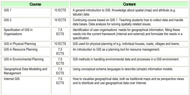
In the E-GIS project [1, 2], 10 partners from six European countries; Bulgaria, Lithuania, The Netherlands, Norway, Sweden and Portugal participated. During the project period a study program, 100 % Internet based, corresponding to one year full time study was implemented – resulting in eight course modules (fig.1) that were developed and tested out during the project.
Course Content
GIS 1 10 ECTS A general introduction to GIS. Knowledge about spatial (map) and attribute (e.g. tabular) data.
GIS 2 10 ECTS Continuing course based on GIS 1. Teaching students how to collect data and handle data bases. Data analysis for solving spatially related issues.
Specification of GIS in
Organisations ECTS 7,5 Identification of user organisations’ needs for geographical information, fitting these needs into the current framework (internal and external) and formulate the needs in a specification.
GIS in Physical Planning 10 ECTS GIS used for physical planning of e.g. individual houses, roads, villages and towns. GIS in Resource Planning 7,5
ECTS An introduction to GIS as a planning tool for resource management. GIS in Environmental Planning 7,5
ECTS GIS methods in handling environmental data and processes in a GIS environment. Geographical Data Modelling and
Management ECTS 7,5 Using conceptual schema languages to describe (simple) information models.
Internet GIS 7,5
ECTS How to visualise geographical data, both as traditional maps and as perspective views and to distribute and use geographical data over Internet.
Figure 1. Developed E-GIS course modules, level and content
Some interesting figures from the E-GIS project
Age spanned of students ranges from 20 to 60 years, with an average of 31 years, 70% of the students were men and 30% women, students came mainly from engineering and science backgrounds, 60% were single, 30% lived family lives with children and 10% were married without children, 65% stated that they could find a comfortable study environment at home, 21% did not work while studying while 62% worked fulltime, 6% worked halftime and 9% worked part-time, 10% of students got financial support for their studies from their employer, 4% stated that they did not have easy access to a computer with internet connection while 53% had it at home; 52% at work and 24% found it elsewhere, 95% felt confident as ICT- and Internet users but 13% felt that computers made studying harder.
Challenges
The partnership was spread all over Europe from North to South – and from West to East. Due to this, there were differences in approach to a number of issues around education, such as: differences in technical skills and traditions, copyright problems on learning material, differences in Internet facilities, differences in credit/grading systems, differences in financial situation for staff and students, problems regarding knowledge control (examination) and how to merge/reuse learning material from different institutions in a new course. Further differences were streamlining, high drop-out rates and differences in language skills and differences in pedagogic approaches.
eGIS+
Due to those experiences, challenges and success of the E-GIS project [1, 2] all former partners agreed on applying for a new project under the Leonardo Life Long Learning Program, Transfer of Innovation. The project proposal was accepted and eGIS+ was born.
The main idea of this project is to adjust and further develop courses in order to fit the results into a broader range of user organisations and user groups within EU. This will be achieved by identification and analyses of needs and selection, adjustment and development of appropriate material (e.g. by translating parts of courses and use new technical tools and pedagogy). The project aims are to try out new digital technologies and create more flexible pedagogical models for adaptation to different types of target groups.
Aims, objectives and target groups
The GIS courses developed by the E-GIS project [1, 2] were proven to be relevant and of high quality and the
E-GIS project [1, 2] was considered as being successful. However, due to e.g. language difficulties, cultural barriers,
diverging views on pedagogy and the use of technology in education, access to not high enough capacity Internet connections and different economic situations they are not as extensively used in some partner countries as anticipated.
The objectives are to:
• develop information material and courses that are accessible at no or low cost. This includes use of open source solutions, both for development and management of courses (Learning Management Systems, LMS, such as e.g. Moodle) and for GIS work to improve accessibility and flexibility for people,
organisations and countries with lesser means of funding GIS implementation and use.
• include the European INSPIRE initiative concepts in the courses developed during the past E-GIS project. This includes knowledge transfer concerning new joint European standards for spatial data storing and sharing, as well as how to access these data.
• break down the existing courses into smaller components suitable for training situations outside the traditional academic spheres.
• develop small general courses as well as more specialized ones, depending on target group. Focus will be on three main target groups: employees (for work based learning, just in place and time to facilitate flexibility), university students and staff and secondary school teachers.
• widening recruitment by developing new pedagogic concepts targeting sub-groups e.g. disabled persons (WAI-standard), refugee minority groups and prisoners.
• investigate and develop technological solutions.
• reduce language related problems by translating courses and parts of courses to a number of European and non-European languages (e.g. Portuguese, Greek, Spanish, Lithuanian, Bulgarian, Polish, Russian and Arabic, the latter two for minority language groups in Europe).
• involve new partners in the cooperation in order to widen the competence used for course development. The impact envisaged is that people, universities, private- and civil service organisations involved will start using technology and methods developed in the project and see the benefits of GIS as a genuine tool for organising spatial data, and increasing the interest from school teachers and secondary school students. Typical learning outcomes for people will be higher qualifications suited for specific careers, better understanding of GIS at different levels, and training in using Internet as a learning platform, knowledge and experience in international cooperation.
Activities in eGIS+ groups, but probably also with some change of the content, depending on the
specific target group.
The courses from the E-GIS project [1, 2] described above (fig.1) will serve as a base and one can study up to a full course or a program. The aim with eGIS+ is to provide shorter courses (more on demand) for different target The aims will be fulfilled through:
• design, development and organising a web-portal for information, dissemination and course implementation.
• short modules varying from a few minutes up to a couple of hours. Different presentations adapted to different target groups. Video, audio, pictures, text with local GIS examples in partner countries. The modules will be translated to a number of languages and with open access for anybody.
• extraction of content from E-GIS courses. All partners will contribute to translation and providing national and regional examples. The modules will be free of use for interested people. Necessary GIS software must be of type free of use for end-users.
• two weeks short courses (three courses) - introduction to GIS
- special subject e.g. archeology
• revise GIS modules from E-GIS
eGIS+ is a typical dissemination project and the efforts and success in dissemination is crucial. The project and it’s results will be presented at national and international conferences.
Partners
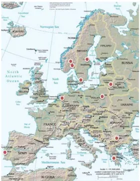
The partnership comprises the university partners from the previous EGIS project [1, 2], one new university
partner and three new stakeholders within GIS (fig 2).
Figure 2. Outline of the partners in eGIS+
Challenges
There are challenges ahead; courses more or less on demand, small modules to be combined up to a full program, new pedagogy, open sources and multimedia tools, new target groups, new ideas, new concepts, LLL and 3rd mission aspects and new partners.
Expected results
Expected results will be to obtain awareness of GIS to a higher extent and spread the GIS knowledge to broader audiences. This will be fulfilled through activities as shown in fig. 3.
Activity Expected results
Gjøvik University College (GUC), Norway ( contracting and coordinating institution)
Lund University (LU), Sweden Bulgarian Academy of Sciences/Solar Terrestrial Influences Laboratory (BAS-STIL), Bulgaria
University of Patras, Greece (UoP) Vilniaus Gedimino Technikos Universitetas, (VGTU), Lithuania Institute for Geo-Information Science and earth Observation (ITC), The Netherlands
Statens kartverk (SK), Norway Centrum Informacji o Środowisku UNEP/GRID-Warszawa (GRID), Poland Instituto Superior Técnico/Universidade Técnica de Lisboa (IST), Portugal Lantmäteriet (LM), Sweden
Web-portal for dissemination of GIS information and application examples, linking to GIS course modules.
To develop a Web-portal for all output from the project, some of it being available for free to the public some password protected. Dissemination of knowledge and awareness of GIS as an exiting and useful tool for society. The objectives are to create interest among public for GIS, interest for use in
organisations and hopefully interests among teachers and students to study GIS.
GIS information and application examples and short GIS course modules (max 2 days)
To produce GIS information of various levels and makes this available on the web portal. One level will be two to five minutes promotion videos, one will be a two hours GIS introduction and the third level will result in a two-day short course about GIS. Examples from different fields, nations and cultures will be produced and added separately to the web portal. The information courses as well as the examples will be translated to several national and minority groups languages. New teaching and training
methodologies and course materials including adoption of new pedagogic eLearning concepts, technology advancements as open source LMS and GIS, will be implemented. WAI standard will be adopted in order to expand the number of possible beneficiaries. No academic credits are given for attendance and the material is made freely available through the web portal.
GIS 3 ECTS (2 week) short course development
Three courses covering different GIS aspects will be constructed, one introductory course, one dealing with GIS applications e.g. archaeology and one covering the implications of INSPIRE on contemporary GIS activities in EU. The development of course material will involve implementation of new teaching and training methodologies and course materials including adaptation to new eLearning concepts, technology advancements as open source LMS and GIS, and new user categories, hence WAI standard adopted material to expand the number of possible beneficiaries. The courses will be available through the Web-portal and awarded three ECTS credits.
GIS 10 ECTS course revision and adaptation
A basic GIS course intended for Internet based education will be developed. Improvement and further development testing new pedagogic concepts and technologies using an existing course as basis. The course will be adapted to user groups who need deeper basic knowledge about GIS and the use of GIS with particular focus on groups that have difficulties accessing Internet based education programs, e.g. adopt course material to WAI-standard. Course content will correspond to 10 ECTS credits and made available through the Web-portal.
Dissemination, evaluation and valorisation
Two distinct type of dissemination results are discernable; first the dissemination of the project methodologies and best practices and other experiences made during the project concerning
methodology, pedagogy, technology, etc is a major dissemination result and secondly the dissemination of GIS and GIS knowledge and skills aiming totally different target groups. This activity mainly focuses on paper production and conference participation for dissemination of results to as many target groups as possible within the European society. The web-portal will also constitute an important tool for dissemination.
Figure 3. Overview of activities and expected results in eGIS+
Evaluation and valorisation
The project strategy is to make the portal known to as many potential user and user communities as possible by means of advertising using the networks that already exist between the partners, institutions and organisations inside as well as outside the European Union. With the geographical and sectorial spreading of the partners in different language spheres it is obvious that the project will succeed in disseminating this information to a wide variety of places, reaching large number of stakeholders.
Sustainability
One anticipates that further developments of the E-GIS material even more will be attractive in universities and higher education institutions and in the open market among private, civil service organisations and public in general.
Many people nowadays, use GIS applications in daily life unconsciously. eGIS+ will create awareness about GIS applications and usability.
The eGIS+ in born, with rich fertilization it will grow, inspire people and society and become sustainable!
References
1. SPONBERG,H.;OSSIANNILSSON,E.;JOHANSEN,F.;ONSTEIN,E. (2006). FoV Report no 9, Lund University European GIS Course Developments. Partner expectations and results in the E-GIS Project.
2. PILESJÖ,P.;MÅRTENSSON,U.;ONSTEIN,E.; JOHANSEN,F. (2006). FoV Report no10, Lund University Learning GIS over the Internet. Development, implementation and experiences of the one-year E-GIS program.