Scientific Press International Limited
The first Century of Islam and the Question of
Land and its Cultivation (636-750 AD)
Nasrat Adamo1 and Nadhir Al-Ansari2
Abstract
The new era after the fall of the Sasanian Empire, which is marked by the Muslims dominion over Iraq, as part of the Islamic Empire. It was only two years after the death of the Prophet Mohammad that the real efforts to spread Islam outside the Arabian Peninsula were made during the reign of the second Khalifah ‘Umar ibn al- Khattab. The Arabs at that time pushed their way forcefully into Iraq, and almost simultaneously into Syria (Bilad al- Sham) and caused the total collapse of the Sassanians Empire and the occupation of large part of the Roman Empire. The Islamic troops that invaded Iraq settled with their families in new towns, which they had built as encampments. Basrah and Kufa were the first of these towns and followed later on by Wasit. The locations of these cities and the further steps taken in their development are described here. Basrah being at some distance from Shatt- al Arab and the Euphrates had no water supply and therefore two large canals, the Ubulla canal and al- Ma’qal canals, which were excavated on the orders of ‘Umar himself, brought water to it. The policy adopted in the following years was to grant the lands around Basrah freely to wealthy Muslim investors who should reclaim these lands and excavate irrigation canals for their cultivation. This was known as the qati’as system of land ownership, which resulted in a boom in agriculture in the area. The treasury had benefitted from the tax imposed on these lands and their yield, which was called (Karaj). The same qati’a system was practiced in Kufa but to lesser extent than around Basrah as most of the land was already cultivated and owned by people who did not resist the Muslims conquest and therefore they were entitled to keep their lands against payment of another type of tax. The only lands that were granted as qati’as were those, which had belonged to the Persian Crown or owned by Persians who had left after the conquest. The lands in this area mostly belonged to the He’rians who had their capitol al- Hira, close to Kufa and their kingdom was a vassal kingdom under the Sassanians. In the other case, of the city of Wasit the
1 Consultant Engineer, Norrköping, Sweden.
2 Lulea University of Technology, Lulea, Sweden.
Article Info: Received: February 10, 2020. Revised: February 15, 2020.
third Islamic city to be built in Iraq, established by al Hajjaj. He was the governor of Iraq during the Islamic Umayyad dynasty rule (661- 750). The town he had built was on the right bank of Tigris in the rich district of Kaskar south of Misan .It was renowned for its fertility and good agriculture. Nevertheless its lower part had been flooded by the famous flood of the 629 AD late in the Persian empire timeline in which the Tigris River had abandoned its eastern course (present day course) and ran in a new western course on which Wasit later on was built. The Hajjaj who ruled for 20 years during the Umayyad period therefore had the opportunity of reclaiming large tracts of the land around Wasit and large areas adjacent to the Great Swamp (Batayih) in which he also gave many of the qati’as grants to investors in the same way as was done before in Basrah. Generally, Hajjaj who was very much occupied in quelling revolts and mutinies had also the time to oversee maintenance works of existing canals and dig many more of them.
Iraq, during this period and for a long time, which followed, became as wealthy as it used to be during the high time of the Sassanids, and its canal networks functioned well while its fertile and fluvial land supported flourishing agriculture and generated large revenue to the treasury (Bait al- Mall). All the time during the Islamic era until the fall of Baghdad in 1258 AD Iraq was called al- Sawad land, which came from the dark color of the extensive cultivations, farms and lush green orchards of palm trees and fruits as they appeared on the horizon. Al Sawad as defined by the contemporary Muslim scholars extended from Hulwan (Qasir e- Shirin) to Haditha in the north to the tip of the Gulf and Qadisiyya on the edge of the desert in the South.
1. The first Century of Islam
At the beginning of the seventh century AD., Mesopotamia witnessed a profound change, for this time represented a pivotal point in history, not only for Mesopotamia, but for the whole region. This period witnessed the rise of a new religion, which stood on equal footings with the two other monotheistic religions, namely Christianity and Judaism; that is Islam. The spirit and zeal of the followers of this new religion resulted in changing the way of life, values, and traditions of many Peoples, not only in the region, but in a much wider sphere of influence. At the zenith of the Islamic Empire, its boundaries extended from the Atlantic Ocean in the west, to the Sind river valley in the east, and from Transoxania the middle of Asia in the northeast, down to the Indian Ocean in the south, and the Sahara in the southeast. Islam dominated even the Iberian Peninsula in southern Europe for some 400 years. Both the Sassanid and Roman Empires suffered bitter defeats at the hands of Muslim Arabs who pushed forcefully from the Arabian Desert at the onset of this period. The expansion outside the Arabian desert boundaries was motivated by; first, spreading the new religion and converting more people to it, and second, to establish the temporal rule of Islam and lay hand on the riches and treasures of these Empires.
The Arabs of Mecca had previously come in contact with Mesopotamia and Syria in the pre-Islamic era through trade. The rich Quraysh clan of Mecca, to which the Prophet Mohammad belonged, used to have their merchant caravans visiting Mesopotamia and Syria twice a year to trade. This active trading with the two empires necessitated forging agreements with both empires for the passage and safe return of these caravans, at times when the two empires were at rift over the trade roads. The long wars between them reflected on both of them and left them tired and weak, a fact that was taken in well and was made advantage of by the invading Muslims[1], [2]. So at the time of their expansion, the Muslim Arabs knew what great prize was waiting for them there.
The Arabs had known Syria, which belonged to the Byzantine Empire, by the name
Bilad Al Sham, and knew well Mesopotamia, which belonged to the Sassanid Empire, by the name of Iraq. While Mesopotamia was the name given to this land
by the Greek and Roman historians, the actual name used by the Arabs was Iraq. The origin of this name, however, is believed by many historians to have come from the word (Uruk) which means (Settlement) in the Sumerian language, and refers also to the Sumerian City State (Warka) [3].
It was a well-known fact, thousands of years before the Muslim conquest that, the lands of Greater Mesopotamia, if properly irrigated and managed, could attain a productivity which could not be found anywhere else in the Islamic world. Estates in the alluvial lands between the two rivers and the riverine areas of the Euphrates valley areas could be extremely profitable for those who owned them, supporting a gracious and cultivated life in palaces and cities. Rough calculations based on early
Abbasid revenue lists suggest that the alluvial lands of southern Iraq had generated
Egypt, and five times as much as all Syria and Palestine combined. This intensive agriculture was almost entirely dependent on artificial irrigation [4].
The Muslim Arabs, however, after their conquest of Iraq, called this land, the land of al-Sawad “Ardh Al Sawad” or shortly “Al- Sawad” meaning the dark land. The dark green color of the thick palm gardens stretching all over the horizon, gave the illusion of darkness. This indicated also the great fertility and large extension of the cultivated land. Al- Sawad covered all the land that was conquered by Muslims at the time of the second Khalifah ‘Umar ibn al- Khattab. Geographically, Al- Sawad extended from Hulwan on Hulwan River (Al Wand River) close to the old town (Qasr- Shirin) in the present day Iran, to just above Tikrit and extending west in a straight line to Haditha, marking the northern boundary. In the South it extended from the tip of the Gulf in the east to Qadisiyah close to the historic city Al- Hirra, the capital of the Lakhmids vassal Arab kingdom of the Sasanian Empire located to the west of the Euphrates. This kingdom had played an important role in the history of Iraq before and after the Islamic conquest. To the north of Sawad, the area between the Tigris and Euphrates was named “Jazira”, meaning “Island:” as this land was enclosed between the two rivers. This part of Mesopotamia depended mainly on rain fed irrigation, except for its upper margins along the Khabour River in Syria; therefore, it will not be discussed in this narration, although, its fertility and large yield of crops such a grain and other cereal crops contributed enormously to the wealth and good of the successive empires.
Within four years after the death of the Prophet Muhammad in 632 AD the Muslim State had extended its sway over all of Syria and, at a famous battle fought during a sandstorm near the River Yarmuk the Muslim Arabs blunted the power of the
Byzantines during the rule of ‘Umar bin al- Khattab .‘Umar, who served as the
second Khalifah (Khalifah means a successor to the Prophet Mohammad) for ten years, ended his rule with a significant victory over the Persian Empire. The struggle with the Sassanid realm was opened in 636 AD at al-Qadisiyah very close from al-Hira in Iraq, where Muslim cavalry had successfully coped with elephants used by the Persians as kind of primitive tanks. In the Battle of Nihavand (642), also called the “Conquest of Conquests”,) ‘Umar sealed the fate of Persia; henceforth, Mesopotamia was to be one of the most important provinces in the Muslim Empire. Iraq was the greatest prize of this conquest, and it was distained to be one of the wealthiest willayat (Satrapy) of the Muslim state.
The expansion of the Muslims from Arabia northwards, as explained already, was fueled by two important drives; the first one was the desire to spread Islam according to the doctrine set by the Quran and the Prophet, and the second was the great prosperity and wealth of both the Persian and Roman Empires (Byzantium). According to traditions recorded by Muslim historians of the ninth and tenth centuries, the account of the great colonizing drive was credible, and independent sources confirm this. Inspeaking of Iraq alone it cannot be overstated that this area was one of the wealthiest parts of the Sassanid Empire and the world. The agricultural economy was most advanced and prosperous and gave the empire its abundant financial recourse of taxes; and fueled at the same time trade and
communal activities.
The Sasanian kings established numerous cities and settlements, forcibly transplanted thousands of prisoners from Roman territory and elsewhere in Mesopotamia and constructed great irrigation, and flood control works apart from those they preserved from the previous empires. It would seem that by the late
Sassanid times, irrigation, settlements, and cultivation in Mesopotamia’s flood plain
had reached their pre-industrial maximum extent. All viable water resources were exploited in an effort to extend as to intensify agricultural production. Thus, summer cultivation involving various exotic plants (rice, sugar, cotton) had probably became widespread by this time. The kings employed corps of engineers as well as a group of specialist workers in maintaining irrigation works. Later on in the Muslim period, the army was occasionally used for emergency repairs. Scattered references indicate that the hard and exhausting work involved in construction and maintenance of the great feeder canals must largely have been performed by unpaid slave labor. However, how the work force was mobilized and organized is not known. It seems that the digging and upkeep of the small canals were often done on a local communal basis. In any case, the purpose of the whole enterprise seems clear enough: it was to enlarge the tax base.
The Mesopotamian floodplain constituted the largest potentially irrigable area in southwest Asia and it was of crucial importance to the successive empires of that region; consequently, their kings determinedly attempted to maximize its agricultural and fiscal potential. There is no reason to believe that some sort of population pressure constituted the real “prime mover”. Population certainly increased in the process, but that was more likely a consequence rather than a cause of the expansion [4], [5].
Nevertheless, while the quantity of water was reasonably reliable, the irrigation system needed constant investment and maintenance. In this environment, almost all-major irrigation systems were gravity fed. This meant that water had to be carried in canals, which were higher than the surrounding land. This in turn meant that the system was highly vulnerable; breaches in the banks of the main rivers would cause water to flood out into fields and be lost, and even lead to the destruction of the canal systems.
There were other hazards; if the gradient were not steep enough, silt would be deposited on the bottom of the canals and would have to be re-excavated at a great expense. If the gradient were very steep, the river would scour itself, but the pressures on the banks would be more serious. And then, as the cultivators of Basrah were to find in the ninth century, there was the issue of salinization; lack of proper drainage would result in the build- up of salts on the surface of the soil so that even the back-breaking labor of thousands of black Zanj slaves could not restore the fertility. Such irrigation systems are also very vulnerable to financial and political issues. The constant required maintenance would suffer considerably in cases of lack of funds or during instabilities. Lack of maintenance will certainly lead to the ruin and the collapse of the agricultural system. In the canal- based agricultural systems of Mesopotamia, the destruction of a major canal might take years to repair,
during which the inhabitants might move elsewhere or revert to the more secure economic refuge of a nomadic lifestyle [6].
During periods of weakness or trouble within the Sassanid Empire, especially during late stage, public works, irrigation systems and flood protection works within Mesopotamia suffered from neglect and lack of attention and maintenance, which caused some irreversible changes in conditions of southern Mesopotamia. Just few years before the Islamic conquest of Iraq, one historical event had occurred, which contributed to the Arabs victory on one side and changed the face of landscape of southern Iraq on the other. An account of this event was reported by the Muslim geographer and historian (Al- Baladhuri) who lived some centuries later during the Islamic era. In his book Futûh– al- Buldan (Conquering the Lands); he described thegreat flood of the Tigris and Euphrates in 627/ 628 AD and the failed attempts to strengthen the neglected flood embankments, which led to the breaching of many sections of these embankments [7].This event was fully described in paper 6, and the reader may refer back to it. All efforts to close these breaches were futile and the result was the flooding of the low lands at the southern part of Iraq between Missan and Basrah, and the formation of the “Great Swamp” which the Muslim geographers called “Al- Bataih” (the plural of Batihah signifying a “lagoon”).
At the same time the Tigris River changed its course at a point, called Kut- Al-
Amarah, which is located at the medieval village called (Madhraya) downstream of
the present-day city of Kut. It took a new course to the west of the old one and followed the course of a smaller channel known as Shatt al Hayy as reported by LeStrange [8] which is called today as Shatt- Al Garaf. The old course was then named “The Blind Tigris” as the flow of water was cut off from it, and it had a blind end except for a small channel called Nahr Abu-l- Asad. All the efforts of the
Sassanid to divert the water back to the old course failed and the dam they built for
this purpose could not withstand the pressure of water and was washed away. Two contemporary Iraqi Scholars Bashir Francis and Georges Awad, in their translation of LeStrange book cited above, have mentioned in footnote (1) on page 43 of their translation, that the new course was actually the course of the old Dujayla
canal (not the Dujayla canal of today), and reported that the remnants of this old
canal can still be seen today [9].The importance of this event stems from the consequences of the change of the Tigris river course, and that all the irrigation water was cut off from the fertile lands east of the “Blind Tigris”. These lands, in the course of time, became barren land as described by (ibn Rustah) who visited the area in the 9th century [8].
The Tigris River, in its new course, after expending most of its water by irrigation channels, finally spread out at the Great Swamp, which also received more water from the Euphrates River during flood events. On this new course of the Tigris Al-
Hajjaj, the governor of Iraq, during the reign of ‘Abd al-Malik ibn Marwan, the fifth Khalifah of the Islamic Umayyad dynasty, built the city of Wasit in 703 AD at the
district called Kaskar as will be explained later on.
At the time of the Islamic invasion of Iraq Kaskar and Maysan were the two districts of the eastern part of the Great Swap. Kazwini (1227- 1304 AD) an Arab Muslim
historian and geographer, who was born in the Caspian region of north Persia, described Kaskar as a very rich region, which produced excellent rice that was exported. On its pasture`s buffalos, oxen, and goats were fattened; the reed beds sheltered ducks and water fowl that were snared and sent in to the markets of the surrounding towns, while in its canals the shad- fish called (Shabbut) was caught in great numbers, salted and exported [10].
The whole area covered by Al- Bataih (Great Swamp) was dotted with settlements and villages, each standing on its canal, and though the climate was very feverish the soil, when drained was most fertile. All districts of Iraq north of the Great Swamp, between the two rivers, were at that time traversed, like the bars of the gridiron, by a succession of canals, which were supplied by water from the Euphrates and drained eastward in the Tigris. While at the east of the Tigris, one canal 200 miles in length, called the Nahrawn, starting from below Tikrit and re-entering the river fifty miles north of Wasit, affected the irrigation of the lands on the further Persian side of the Tigris [6].
One of the natural consequences of the Islamic conquest was the sizable booty that fell into the hands of the conquering Muslims. Most of the wealth available to the conquerors was immovable because it came in the form of land. Much of the most productive land was Crown Land, and this, in addition to the land owned by local elite, became available to conquering Muslims through abandonment and confiscation. In the Sawad the ‘black’ area of alluvial soil in central and southern Iraq, where information is fullest, Crown Lands included not only all the properties of the Sasanian royal house, but also those attached to fire temples, post houses and the like. The second Khalifah ‘Umar is said to have distributed four fifths to the soldiers and kept one fifth as his share as Khalifah, which was to be used for the benefit of the community.
As far as labour was concerned, ‘Umar’s policy was conservative: the peasants were left to work the land. This policy was part of a more general laissez faire style of ruling. In this policy non-Muslims who in the first decades of Islamic rule were generally lumped together with non-Arabs, enjoyed wide ranging autonomy. Elsewhere abandoned lands were snatched up, and lands owned by those who had resisted (or could be said to have resisted) the Muslims, were confiscated. It may be that redistribution to conquering tribesmen was left to the discretion of local authorities. In some cases, such as the well irrigated and thus valuable land in the northern Mesopotamian city of Mosul, it is clear that ‘precedence’ was in operation, as we would imagine it to be: first come, first served; the best lands often went to the earliest settlers, although it appears, there was no land grab. Whatever the value of the booty and confiscated land, conquerors and conquered alike had to make sense of the momentous events. For Muslims, the conquests demonstrated God’s continued participation in human affairs [11].The distribution of this land led to the
land tenure system that prevailed later on for very long time during this era. Muslims realized since the start, and just after settling in the new lands, that
sustaining the agricultural production in all these rich lands can only be achieved through proper classification of land and a proper land tenure system. In the same
connection, they were open to the fact that a fair taxation system coupled with clear collection methods would help to generate much of the funds needed for the proper functioning of the State. So a new system of land tenure was established, and taxes were imposed accordingly.
Tax on the agricultural land was called “Kharaj”. In the general meaning; Kharaj means all the revenues collected by the State which go to the treasury and which shall be spent on the good of the public. As tax it also has the special meaning of the tribute imposed by the Khalifah on the yield of the agricultural lands. The term indicates the meaning of output of the land. This system was applied all over the concurred land, but with slight variations here and there according to the local conditions. In the Sawad the ‘black’ area of alluvial plains in central and southern Iraq, the lands were classified into three categories.
The First; were those agricultural lands taken by force (or by the Sword) during the invasion. They included the lands, which belonged to the Royal House, the elite class, and aristocracy, and the lands of the temples and the like as already mentioned. These lands were considered as endowment for the Muslims. The second were the lands abandoned by their owners, and they were treated in the same way as of the first category. Most of the “Al- Sawad’ lands belonged to this type. The Third, land type was that which belonged to those people who surrendered to the authority of the invaders peacefully and concluded conciliation agreements “Sulh” with them. This type was treated according to the conditions stated in the “Sulh” agreement, so either the ownership was transferred to Muslims against compensations, or they were left to their original owners to use and cultivate but to pay Kharaj on them. Many large tracts of land belonged to this category in Iraq like “Sawad Al Hira”, the area west of the Euphrates between Anbar and Basrah.
The estimation of “Kharaj” rates was left to the Khalifah or his authorized representative. This estimation should be based on the fertility of the soil, type of the crop, method of irrigation whether by gravity or by lift irrigation and in some cases the distant from the markets was also considered. The collection of the Kharaj revenues was done in one of three methods. Either by imposing it as per unit of area of the agricultural land, as was done by the Khalifah ‘Umer in Al-Sawad, or per unit area on the actually cultivated area, or even by taking a certain percentage of the crop yield [12]. In his book Futûh– al- Buldan or “Conquering the Lands) of a 9th
century Muslim historian, Ahmed ibu Yahya al- Baladuri already mentioned, he stated that during the rule of ‘Umar, the Kharaj tax was imposed on an area of thirty-six million Jareeb which was equal to about fifty thousand square kilometers. This area represented then two thirds of all the cultivated agricultural lands in the delta between the Tigris and Euphrates rivers. It makes one eighths of the area of the present-day Iraq[13]. During the early days of the Muslim settlement in the newly conquered lands, another new form of land ownership and a new type of tax emerged by necessity, especially in the lands around the newly built city of Basrah. This type was called (qati’a) and the tax was called (ushur), as it will be described in more details later on.
Khalifes to organize the administration of the new conquered lands and two new
cities, “Al-Basrah” and “Al-Kufah” were founded in 638 AD.
The two cities were intended as encampments for the Muslim soldiers and settlements for their families. All the land around them was divided among the Muslim tribes who were in garrison here after the collapse of the Sassanid Empire.
Al-Kufah became the capital of the Islamic Khilafa state during the rule of the fourth Khalifah Ali bin Abi- Talib, but after his assassination, the rule changed into the
hands of the Umayyad dynasty, a competing clan from Quraysh, who then moved the capital to Damascus in Bilad Al- Sham. Even then Iraq kept its special place as the wealthiest and the most prosperous land within the lands of the new empire.One more city “Wasit” was built later on in Iraq during the reign of the Umayyads, and two other new cities, Baghdad and Sammara, were also built later on during the reign of the Abbasid dynasty, which followed the Umayyads. The building of these new cities reflected the need of centers for administrative, agricultural trade and military activites, and these cities became focal points of the Khilafa State, and played important roles in promoting the maintenance and construction of new irrigation projects and enhancing agriculture in Al- Sawad.
The choice of locations of the two new Islamic cities, Basrah and Kufa, was not dictated by economic consideration as much as for the need for establishing military bases, which were required to continue the conquest of what remained of the
Persian Empire on one hand, and to facilitate the governance of Iraq on the other. Basrah, it is said was founded by the Muslim leader Utba ibn Ghaswan in (638AD)
to house the Arab army, which was then engaged in the conquest of southern Iraq,
Khuzestan and Persia (Fars).
The exact reasons for the choice of this particular site are obscure. It lay some fifteen kilometers in a direct line to the west of Shatt- Al Arab which was called then (Fayd
Dijla) by the Arabs and (Bahmanshir) by the Persians, and therefore, had no direct
access to the maritime trade of the Gulf and, at the same time, it was on the edge of the desert. All the evidence available today indicates that this area was barren and did not have any extensive agriculture hinterland. Furthermore, it clearly lacked adequate and reliable supplies of drinking water. Despite these apparent disadvantages, the role of the city as center where salaries were paid to the troops meant that the financial drawing power of the settlement proved sufficient, at least for a couple of centuries, to overcome the natural disadvantages of this situation. Population seemed to have grown in Basrah very rapidly, which resulted in a major campaign of investment in new irrigation projects in the land between the city and Shatt al- Arab, which is described in considerable details in al- Baladuri’s Futuh-
Al buldan [14]. His account, which has already been studied by historians, is of great importance. It is the only account we have from Iraq of property ownership and land development in the first century of Islam.
The first canal to be dug in the area was intended to supply the new city with drinking water. Lack of drinking water had caused great hardship to the population, to the extent that they had sent one orator named al- Ahnaf ibn Qays to plead
‘Umer was so moved by the orator’s words that he immediately ordered his
representative Abu Musa al Ashari, to dig a canal (Nahr).
‘Umar himself regarded the provision of water as part of the function of government.
The digging of canals was very expensive, but the project was deemed to be so important that the governor who was sponsoring it said that he would, if necessary, use all the tax revenues of Iraq on it. It followed that Abu Musa dug what became known the Ubulla canal from Shatt al Arab to Basrah and then extend it back in southeast direction to empty again in Shatt- al Arab. Maintenance of this watercourse was a constant struggle and much of Abu Musa’s canal, had to be re-excavated by Ziyad ibn abi Sufyan, the governor during the reign of the Khalifah
‘Uthman ibn Affan (644-560), the third Khalifah and the successor to ‘Umer ibn al- Khattab. At the same time, ‘Umar ordered Abu Musa to dig the Ma’kil canal. The Ma’kil canal led water from the Euphrates at the southern edge of al Bataih to the
town and allowed boats with supplies from the rest of the Sawad to reach the city, while to the south, the Ubulla canal connected the city to Shatt- al Arab (Fayd Dijla). The two canals and Shatt- al Arab formed the Great Island, as it was called, in which
Basrah stood; and the old city of Ubulla at its south east was located above the
confluence of Ubulla canal with Shatt- al Arab.
These important civil engineering projects provided the city with drinking water, satisfied the mosques needs for ablution water, and provided water to the public baths of the city. Additionally, they allowed boats carrying goods and provision to reach it from the rest of Al-Sawad. The two waterways allowed traffic to pass also from Basrah going southeast back to Shatt- al-Arab and then to the Gulf. The obligation of the government to provide drinking water is confirmed in other writings, which belonged to the end of the Umayyad period in the reign of the
Khalifah Yazid ibn al Walid (744 AD). The logical consequence to the digging of
these two canals was the raised interest in cultivating the land around Basrah and the construction of a dense network of irrigation canals. This new activity was also encouraged by the introduction of the new land tenure system known as the qati’a grant.
Al- Baladuri attributed the rapid development of Basrah, and the cultivation of the
lands around it to this new qati’a system of land ownership, and to the reduced rate of land tax imposed on it. The idea underlying the concept of qati’a was that dead land (mawat), brought under cultivation usually by irrigation, but also by drainage or the clearing of bush, should become the property of the person or persons that had made it productive. It was held in absolute ownership and was alienable (it could be sold)and heritable. Moreover, the tax levied on such lands was the “’usher which was much less than the higher Kharaj (land tax) paid on most agricultural lands. But it must be understood that “’usher was only charged on qati’a when the granted lands required investment for digging canals, erecting farm buildings and other heavy expenses for the farming of the granted qati’a. Such qati’a was developed by people rich enough to invest substantial funds in making the land productive. This indicates that the agricultural existence of the new towns encouraged a new class of entrepreneurs to invest in large scale irrigation works.
The qati’a system seems to have been constituted for the first time by Khalifah
‘Umer, who ordered the granting of two plots of land under this system in two
occasions. The first one, in a letter to al- Mughira ibn Su’ba, governor of Basrah instructing him to give qati’a to one Abu ‘Abd Allah Nafi’ ibn Harith, who had cultivated some land beside the Tigris in the area of Basrah. He used it as pasture to raise horses there. The other one being given to ‘Abed al- Rahman ibn Nufy’ ibn
Masruh nicknamed as (Abi Bakra), a former slave from Taif and one of the early
converts to Islam, who had been one of the early settlers in Basrah, and he was in charge of engineering the digging of the Ubulla canal to Basrah.
Most of the canals serving the qati’a land were named after families and individuals and took the form of Nahr (this), or Nahr (that). It is the writing of al- Baladuri again which helped in constructing the picture of this development in the Basrah area in the first half of the first century of Muslim rule. The first major wave of canal`s construction was undertaken during the governorates of Abd Allah ibn Amir in (649- 650) and (656- 661), and his successor Ziyad ibn Abi Sufian (665-673). Examples of such canals were Nahr Salm, Nahr Quotybatan, Nahr Um Habib, Nahr
Um Abd Allah al- Dajjaja, and Nahr Humayda. Non-Arab citizens (mawali) who
were in the service of Arab Muslim landlords or clans also dug canals and named them in a similar way, such as Nahr Fayruz owned by Fayruz mawla of Bani
Thaqafi, Azraqan canal owned by Azrag ibn Muslim mawla of Banu Hanifa, Ziyadan canal owned by Ziad mawla of Banu Haytham and many others. The Aswira, the Persian elite soldiers who had defected to the Muslims at the time of
the conquest, were credited also with the development of a canal known as Nahr
Aswira. Alongside with them was a group of Isfahanis who had migrated to Basrah
and purchased land from some of the Arabs there, and who probably had converted to Islam at the time.In al-Baladuri’s account, there was only one account of pre- Islamic irrigation works in the area; a canal and a palace belonging to Nu’man ibn
al- Mundhir, the last king of Hira (580- 602), which was given to him in the days
of Kisra (in the late Sassanid period). But it seemed to have been situated on the
banks of the Tigris River not in immediate vicinity of Basrah [14].
The qati’a system seems to have survived the period of the early four Khalifes, and continued through the Umayyad dynasty period which followed. Some examples from this period may be cited here. The first was when the first Umayyad Khalifah
M’uawia (608- 680AD) gave part of the area between the Ma’kil and Ubulla canals,
which was at first largely sabkha, to one of his nephews as qati’a. But when the nephew arrived to inspect his new possession, the young man, was disgusted with the state of the land, which the Governor Ziyad ibn Abehe had arranged to have it flooded prior to his arrival, and so Ziad bought the land for merely 200,000 dirhams, and then dug canals in it and made it into a fertile qati’a. The second case was when the Khilafa Yazid ibn M’uawia gave an area of eight thousand jarbis as qati’a to someone called Hilal ibn Ahwaz al-Mazini. It seems, however, that this qati’a was the subject of a law- suit whichwas raised by al- Mazini’s son, al- Himiyari, who had discovered that this land had been taken over by another man Bashir ibn Ubayed
Baladuri who reported the case does not tell us of the outcome of this law- suit. The
other case also mentioned by al- Baladuri was when Bashshar ibn Muslim al- Bahili gave Hajjaj a particularly fine carpet; so the governor gave him an estate “and dug the canal called (Nahr Bashshar) to serve it” [14],[15].
The other army encampment, the city of Kufa was built about the same time as that of Basrah in 638 AD. The Companion of the Prophet Saʻd ibn Abī Waqqas built it on the desert side of the Euphrates, and occupied an extensive plain extending along the river bank adjacent to the old Lakhmid Arab city of Al-Hīrah. After naming two governors, whom the inhabitants of Kufa had rejected, Khilafa ‘Umar appointed Al-Mughīrah ibn Shuʻbah as its governor. The city was located in the middle of Al- Hirra Sawad near to the site where the Qadisiyah battle was fought with the Persians in 636 AD, who lost it. Mukaddasi described Qadisiyah as a small town on the edge of the desert; its lands were watered by a small canal from the Euphrates. But the area around Kufa itself was very fertile and highly cultivated during the Sassanid period.
The Lakhmid Arab population of al-Hira Sawad who owned most of the land here had surrendered to the authority of the invaders peacefully and concluded conciliation agreement “Sulh” with them. So they continued to own the land and cultivate it as before under the condition to pay Kharaj and an additional tax which was levied per capita known Al- Jizyah if they did not convert to Islam; but would be exempted from if they did so.Therefore, it is expected that the irrigation system did not need many rehabilitation works after the conquest except for major repairs that the farmers could not have done without the help of the State. Al-
Baladuri in his description of the important sites around Kufa in the 9th century enumerated many monasteries and churches, which belonged to the Christian
Lakhmid Arab population, such as: Bi’at (church) bani Mazin, Bi’at bani Ayad, Dair (monastery) al- A’war, Dair Kurrah, Dair as- Sawa, Dair al-Jamajim, Dair Ka’b, Dair Hind, Dair Kumam, and Sikkat al Barid (post office) in Kufa, which was once
a church built by Khalid ibn Abd Allah [16].
In 657 AD the fourth khalifah after the Prophet Ali ibn Abi Talib, moved to Kufa and took it for his residence, but only to be assassinated in 661AD, at which event the Khilafa took a sharp turn and went to the Umayyad dynasty, which was another clan from Quraysh. The first Umayyad Khalifah M’uawia ibn abi Sufian moved the seat of Khilafa state to Damascus in Bilad Al Sham.
The first few Umayyad Khalifahs devoted a substantial part of their reign to political problems, but they always had their eyes on Iraq due to its wealth and large
Kharaj revenue. So that as soon as 'Abd al-Malik ibn Marwan succeeded to the Khilafa in 685 AD, he directed the cleaning and reopening of the canals that
irrigated the Tigris-Euphrates Valley, the key to the prosperity of Mesopotamia since the time of the Sumerians. It is claimed by some writers that he had introduced the use of the Indian water buffalo in the riverine marshes [17], a claim which was disputed by many historians who believed that they were introduced by Alexander when he returned to Babylon from his Indian campaign. Others also had claimed that water buffalos were bred in the southern marshes of Iraq since the times of the
Sumerians. Water buffalos were traded from the Indus valley civilisation to
Mesopotamia since 2500 BC by the Meluhhas. The seal of a one scribe employed by an Akkadian king shows the sacrifice of water buffalo [18].
The need for another new city to be the Sawad capital seems to have risen during the reign of 'Abd al-Malik ibn Marwan, and so the new city of Wasit in Iraq was built in 703 AD by the famous viceroy to Iraq Hajjaj who was appointed to govern Iraq by 'Abd al-Malik in early 694 AD. This meant combining the governorships of
Kufa and Basrah. Al-Hajjaj's purview originally excluded Khurasan and Sistan,
which were in the heartland of Persia, but in 697/8 AD, he received these two provinces as well, expanding his rule over the entire eastern half of the Khilafa State.
Al-Hajjaj at the mean time had embarked on building Wasit and made it the seat of
his government. This decision was dictated by strategic and economical consideration. The name “Wasit’ means “the middle city” and it was so called because it laid at equal distance of 50 leagues, (equivalent to 75 miles) from Kufa,
Basrah and Ahwaz in Persia. It was the chief town of the wealthy Kaskar district on
the new course of the river Tigris, as was explained already. Before the foundation of Baghdad, Wasit had become one of the three chief Moslem cities of Iraq. Wasit was located in the heart of the rich agricultural region of Al- Sawad, and the city occupied the two banks of the Tigris River which were connected by a bridge of boats. The lands around Wasit were extremely fertile, and their crops provisioned all other towns in times of scarcity. Moreover, it also paid yearly into the treasury one million dirhams from taxes as reported by Muhammad Abū’l-Qāsim Ibn
Ḥawqal who was a 10th century Arab Muslim writer, and geographer [8]. After curbing, all the rebellions that rose against the Umayyads in Iraq Hajjaj turned his attention to the construction and improving of public works.
Dietrich in his “Encyclopedia of Islam” writes the following onHajjaj’s works in Iraq:
“Following his victory over the Iraqis, al-Hajjaj began a series of reforms aimed at restoring tranquility and prosperity to the troubled state after almost twenty years of civil war and rebellions. He invested much effort in reviving agriculture, especially in the Sawad, and increasing revenue through the Kharaj land tax. He began to restore and expand the Sasanian era network of canals in the lower Iraq. According to al-Baladhuri, he spared no expense to repair embankments when they broke, awarded uncultivated lands to deserving Arabs, and took measures to reverse the flow of the rural population to the cities, especially the new converts” [19].
In comparing with the ancient irrigation works of the Babylonians an early twentieth century famous British engineer Sir William Willcocks wrote in a report entitled “Irrigation in Mesopotamia” which was submitted to the Ottoman authorities who commissioned him to study the irrigation of Iraq; and he stated the following:
“It is worthy to remark that the only original reclamation works the Arabs
carried out in the delta was an exact copy of this. In the days when Kufa, Wasit and Basra were the capitals of the Moslem world, before the rise of Baghdad, the energetic Emir Hajjaj of Basra reclaimed some 50000 acres in the Marshes between
Kufa and Basra and converted them into one of the four earthly paradises of the Arabs. The ground was green carpet of lucerne, out of which rose stately Palm Trees, sheltering the gardens from the fierce heat of summer and severe cold of the winter; while from Date- palm to Date- palm, were fastened luxurious vines from which hung purple grapes”[20].
On the reclamation works which were carried out by Hajjaj wrote Ibn Serapion that
Hajjaj had employed a Christian Nabathaean called Hassan presumably an
engineer to drain and reclaim lands in the Great Swamp[8]. Hassan, in our opinion, might have been one of the Lakhmids inhabiting the land around Hira, who were very skillful in irrigation works.
The Hira Sawad was very important part of the Iraq Sawad throughout the Persian history, and it kept its prominence after Islam had established itself in the region. Therefore, some additional notes on those people may seem fitting. The Lakhmids of al-Hira were themselves Arab Christians, who had inhabited the area west of the Euphrates between Anbar and Basrah. They descended from the Arabs of the Beni
Tanukh tribes that had emigrated with many others from Saba’ (Sheba) which was
a kingdom in southern Arabia (region of modern-day Yemen). The exodus of the people of Yemen and their dispersal was due to the flood resulting from the frequent breaching of Ma’rib Dam. The dam, considered at its time as one of the greatest engineering feats of the ancient world, was built under the reign of the Sabean
mukarrib Yatha’ Amar Watta I (760-740 BCE), but it collapsed finally, most
probably in 575 AD [21]. Remnants of the dam are located about 150 km east of
Sana’a where a modern dam was constructed lately.
In its good days, the dam supported a flourishing agriculture. Notwithstanding the dam good construction, it had been overtopped several times during its history, but always had been repaired. In the recurrent floods caused by such event, Saba’ was
flooded severely leading to the abandonment of towns and cities, and the inhabitants were forced to leave the area or starve. The Ma’rib dam provided such ample irrigation to the fields that crops were plentiful and were harvested twice a year. The land was generous in its yield of wheat, barley, dates, grapes, millet, and other fruits. Wine was pressed from the grapes and exported as well as consumed locally. Irrigation of these farmlands was so successful that Saba’ was consistently remarked upon as a “green country” by ancient historians such as Pliny the Elder (23-79 CE) who called the region Arabia Eudaemon (Fortunate Arabia). A term which later on was replaced by the Romans who used “Arabia Felix”, and in Arabic literature, it was tagged to the term “Happy Yemen”, thanks to the great skills of these people in cultivated irrigation. From all of these qualities, it may be concluded that those people were very skilful farmers [22].Such skills as mentioned seem to have been transmitted generation after generation to the people of al- Hira, who in the exodus of their ancestors passed through Najran, and Mecca, where they were denied a stay, so they made their way to al-Juḥfa, and then moved on to Yathrib (Madina). Here some of them stayed behind and were settled on the outskirts, while the rest left to Syria and others went to Iraq [23]. This fact explains the strong relations between the Lakhmids of al-Hira and Arabia and especially with Yathrib
(Medina), which was so special, even to the extent that during the Sassanid influence over Medina, the governor of the city represented the King of Hira, a vassal to the Persian King, and was responsible for the collection of taxes for the
Sassanids in this area.
These people found their chance to settle and establish themselves in Mesopotamia in the third century at the time when the Parthian Empire was crumbling and opening the way for rise of the Sassanids. The Hire’en people were recognized by
Shapur II (337-358), the tenth Sasanian King, so they ruled in central Mesopotamia
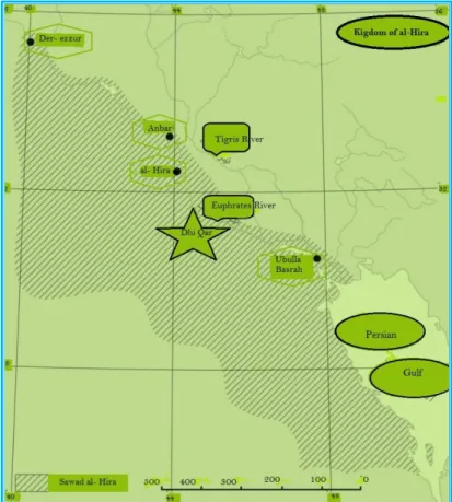
as a vassal kingdom under the Sassanids with their capital at Ḥira which was established on the Euphrates River for roughly three centuries, from about 300 to 602AD, and the, He’rins occupied the area between Anbar and Ubulla to the left of the Euphrates and extended to the edge of the desert; Figure 48 shows the boundaries of Sawad- Al Hira and the location of al- Hira itself. Their other towns included “Akola, Ain- Tamer, Ubulla, Hit, Ana and Baka. The people of al- Hira are known in the Arabic sources as the Hire’en or more often al- Manathirah in reference to their Kings. History books also credit them with the fact that the
Sasanian King Bahram V won the throne with support of Mundhir I ibn al-Nu'man, who was one of their famous kings. Hira became the center for Christianity
since its early days and became a diocese of the Church of the East.
Al- Manathirah managed during the years to make advantage of their strategic
position, living between the Euphrates River and the edge of the desert, and invested this in their relations with the Persians. The privileged position of their kingdom with respect to the Sassanids may have been due to the fact that the Sassanids themselves had lost control of the desert fringes after 602. By 604, their armies seem to have been comprehensively defeated in a battle by Arab`s army alliance, which was to become famous in Muslim narratives- the so-called “day of Dhū Qār”, Figure 48. This was a direct consequence of the act of the Persian King Khusrau II Parvez, who had murder al- Nu’man ibn al- Mundhir the king of Hira in a treachery.
Al-Ṭabarī states clearly that al-Nuʿmān’s fate was the cause of the battle of Dhū Qār,”
by which he implied that had Khosrau retained the alliance with the Persian Arabs, the Sassanids may have resisted their enemies the Byzantines more effectively [24]. Generally, Al- Manathirah were intermittently, the allies and clients of the Sasanian kings of Persia with especially close links during the sixth century when they were bulwarks of the Sasanian positions in Mesopotamia against Byzantium and its Arab allies in Syria. Moreover, their close links with the Arabs of Yathrib (Medina) enabled them to represent the Persian influence in Arabia even to the level that enabled the King of Hira to appoint a governor (‘Amel) for Medina. Ibn Sa’id furnishes us with details on this, and record that ‘Amer ibn Utaiba was appointed by al- Numan ibn al- Mundir as a governor of al- Medina.
In shedding light on the duties of the kings of al-Hira as vassals to the Persian kings and the reward they received in the form of agricultural lands. Kister [25] quotes from the book “al-Manaqib book of Abu al- Baqa” that they were instruments in taming the Bedouins who used to raid the borders of the empire, but they were rewarded for their services, where he says:
“The Chosroes (Kings of Persia) granted the rulers of al-Hira some territories
as fiefs (qati’a) and assistance for them in their governorship. They collected the taxes of these territories and used them for their expenses. They bestowed from it presents on some of their own people and on people (of the Bedouins) whom they blandished and tried to win over. Sometimes they granted them localities from the fiefs presented to them”.
Kister points out that these fifths were restricted to border lands in the vicinity of al-Hira. The rulers of al- Hira could not trespass on other lands, because the territories of Persia belonged to the Dihqans who vied among themselves for their possessions. These lands were very fertile and Abu al Baqa records details about the amount of taxes collected by al- Nu’man, king of al-Hira, from the fiefs granted to him by the Persian king as “the sum was 100,000 dirham or 5 kg of silver”. On the fertility of the lands, he speaks:
“The fertility of the lands, yielded a yearly average of 30,000 kurr (81000 tons
of wheat) in addition to fruits and other produce” [25],[26].
When Khusrau II Parvez appointed Iyas ibn Qabisa as ruler over al-Hira after the assassinating of al- Nu’man ibn al- Mundhir, he granted him “Ain-Tamar and eighty villages located on the border of the Sawad.
So this was the state of affairs in this important and fertile part of Iraq at the time of the Muslims conquests, and as al- Hira Sawad surrendered to the conquerors in a “Sulh” agreement, they were entitled to keep their lands for themselves. The reason of this peaceful surrender to the Muslims was mainly due to the preference of the Christen population of al-Hira to live under the rule of their brethren Arabs, even being of different religions, rather than the Persians, whom they disliked. Moreover, they desired to keep their current prosperity that was guaranteed by the conquerors. This prosperity was insured by their fertile lands, which they kept under their ownership, in contrast to the Persian Dihkans lands, which were confiscated. No doubt an important reason for such prosperity was due to their skills in irrigation, which they had inherited from their ancestors from Yemen. In addition, their date- palms orchards, farms and vineyards extended in the entire domain from Najaf of today to the Euphrates. They produced all sorts of crops, which ranged from dates, barley, and grapes to millet, wheat, and assorted fruits, and they were renowned for their skill in making especially good wine from the grapes they used to grow.
Figure 48: Sawad al Hira, showing the location of Dhi-Qar battle between the Arabs and the Persians (609AD).
The Sulh agreement allowed the people of al-Hira who were very active traders to continue their trading relations with India, China, Oman, Bahrain, Hejaz, Horan and Palmyra by sailing their boats in the Euphrates and the Gulf, or by driving their caravans for very long time after the Islamic conquest. In its close proximity to Kufa, it was visited for its refreshing parks and bars, which exceeded in its number anywhere else. Yakut mentions that it was densely populated during the Umayyads time, but although, it was visited frequently by the Abbasid Khalifahs, Abu al-
Abbas, al- Mansur, Haroun al- Rashid and al- Wathiq, for its fresh air, it began to
decline during the late days of Khalifah al- Mu’tadid [27].
It may be said that a state of prosperity had prevailed in the land of al-Sawad extending from Basrah and Wasit, to Kufah and al-Hira, during the Umayyad dynasty rule which had lasted for 89 years from 661 AD to 750 AD. During this period, which Hajjaj served as the governor of Iraq for 20 years from 694 AD to the time of his death in 714 AD. This period marked the best time not only for agriculture and irrigation works that he had carried out in Iraq, but for all the other administrative works and organization he had fostered. The Encyclopedia
Britannica speaks of him as the most able of provincial governors under the
Umayyads rule and adds:
“Hajjaj first became publicly active when, in the reign of the Khalifah ʿAbd
al-Malik, he restored discipline among troops being used to repress a rebellion in Iraq. In 692 he personally led troops in crushing the rebellion of ʿAbd Allāh ibn az-Zubayr in Mecca. The brutality with which he secured his victory was to recur during the rest of his public life”.
The Encyclopedia Britannica adds:
“For several years, he was governor of the provinces that surrounded Mecca, but in 694 he was made governor of Iraq, which, because of its location and because of the intrigues by various sects there, was the most demanding and the most important of the administrative posts in the Islāmic empire. Al-Ḥajjāj was completely devoted to the service of the Umayyads, and the latter were never fearful of his great power. He was instrumental in persuading the Khalifah ʿAbd al-Malik to allow the succession to pass to al-Walid, who, as Khalifah, allowed al-Ḥajjāj complete freedom in the administration of Iraq. Al-Ḥajjāj did much to promote prosperity in his province. He began to strike a purely Arab coinage that soon replaced older currencies. He stopped the migration of the rural population to the towns in an effort to improve agricultural production, and he saw to it that the irrigation system was kept in good repair” [28].
The end of the Umayyads dynasty (661-750AD) was brought about by a violent rebellion and fighting as in most of similar cases in the history of Mesopotamia. Fighting would continue for some time, but finally the victorious would emerge and inherit all of what had belonged to the loser. Ordinary people, however, would resume their usual life and go about their business in as similar ways as they used to do before. In such way the people of the land of Iraq al- Sawad continued their lives in the new Abbasid era which followed, being farmers, artisans or traders. Cultivation of the fertile lands of Mesopotamia also continued to be the main source of income to the new State of al- Khilafa.
References
[1] Al- Hakawati (2018). “The trading cities before Islam”. (In Arabic. ملاسلاا لبق هراجتلا ندم(
Website visited on 18th September 2018.
http://al-hakawati.la.utexas.edu/2012/05/01/%D9%85%D8%AF%D9%86- %D8%A7%D9%84%D8%AA%D8%AC%D8%A7%D8%B1%D8%A9-
%D9%82%D8%A8%D9%84-%D8%A7%D9%84%D8%A7%D8%B3%D9%84%D8%A7%D9%85/ [2] Fikri, W. Elaf Quraysh- The agreement that changed the map of the area and
the history of the Arabs”. (In Arabic) Raseef 22. (برعلا خيرأتو هقطنملا ةطيرخ تريغ يتلا هيقافتلاا "شيرق فلايإ"( https://raseef22.com/culture/2017/08/12/%D8%A5%D9%8A%D9%84%D8 %A7%D9%81-%D9%82%D8%B1%D9%8A%D8%B4%D8%8C-%D8%A7%D9%84%D8%A7%D8%AA%D9%81%D8%A7%D9%82%D9 %8A%D8%A9-%D8%A7%D9%84%D8%AA%D9%8A- %D8%BA%D9%8A%D9%91%D8%B1%D8%AA-%D8%AE%D8%B1%D9%8A%D8%B7
[3] Iraqi American Wisdom Voice (2018). Name of Iraq, its origin and meaning. (In Arabic). Web site visited on 18th September 2018.
هانعمو هلصأ _ قارعلا مسا http://www.iawvw.com/varieties/1089-2014-11-26-04-15-17
[4] Wilkinson, J.W. (2003). Archeological Landscape of the Near East. Chapter 5.
The University of Arizona Press. https://archive.org/details/ArchaeologicalLandscapesOfTheNearEast2003
[5] Christensen, P. (1998). Section I: Agriculture and Pastoralism, Middle Eastern Irrigation: Legacies and Lessons. Yale University bulletin series,
transformation of the Middle Eastern Environments.
https://environment.yale.edu/publication-series/documents/downloads/0-9/103christensen.pdf
[6] Allen, R.C. and Heldring, L. (2016). The Collapse of the world‘s oldest civilization: The Political Economy of Hydraulic States and the Financial Crisis of the Abbasid Caliphate. New York University, Abu Dhabi and Harvard University.
https://robobees.seas.harvard.edu/files/pegroup/files/allenheldring2016.pdf [7] Hitti, P. K. (1916). The Origins of the Islamic State: Kitab Futuh Al- Buldan
of al- Baladhr. Vol. 1. Faculty of Political Science of Columbia University,
New York.
https://archive.org/details/originsislamics00hittgoog/page/n8
[8] Le Strange, G. (1905). The land of the Eastern Caliphate. Chapter II and Chapter III Cambridge Geographical Series. Cambridge University Press. https://archive.org/details/landsofeasternca00lest/page/n7 Or the 1930 edition.
https://archive.org/stream/in.ernet.dli.2015.39096/2015.39096.The-Lands-Of-The-Eastern-Caliphate#page/n5
[9] Francis, B. and Awad, G. (1985). Land of the Eastern Khilafa Arabic Translation of the book by of G LeStrange in reference 8
https://archive.org/details/BoldanKhelafa
[10] Al- Qazwini, Z. Athar al Bilad. Arabic, p.446 Dar Sader Publishers. Beirut Lebanon.
ينيوزقلل دابعلا قلاخأو دلابلا راثأ https://ia800903.us.archive.org/26/items/Athar_Belad/Athar_Belad.pdf [11] Robinson, C. F. Part II: The rise of Islam 600-705, pp. 199-200. The New
Cambridge History of Islam, Vol. 1- The formation of Islamic World (Sixth to Eleventh Century).
https://ia801702.us.archive.org/14/items/TheNewCambridgeHistoryOfIslam Volume1/The_New_Cambridge_History_of_Islam_Volume_1.pdf
[12] Al Douri, Abdul Aziz (1995). The economic history of Iraq in the fourth Hijri century. (In Arabic). Center for the Arab unity Studies. Third Edition; Beirut 1995 pp. 203- 208. يرودلا : .هيبرعلا هدحولا تاسارد زكرم .يرجهلا عبارلا نرقلا يف يداصتقلاا قارعلا خيرأت : زيزعلا دبع توريب هثلاثلا هعبطلا 1995 . https://archive.org/details/6789054_20171015
[13] Al Hafedh, I.M.D.H. (2005). Dams and water reservoirs in the Arab culture-A wonderful Technical Innovation. In Arabic. Article published in the magazine “Islamic awareness”. No 478, year 47 July- August, pp. 20-25.
https://islamstory.com/ar/artical/25852/%D8%A7%D9%84%D8%B3%D8% AF%D9%88%D8%AF- %D8%A7%D9%84%D8%AA%D8%B1%D8%A7%D8%AB- %D8%A7%D9%84%D8%B9%D8%B1%D8%A8%D9%8A- %D8%A7%D8%A8%D8%AF%D8%A7%D8%B9-%D8%AA%D9%82%D9%86%D9%8A Or http://www.muslim-library.com/dl/books/ar3655.pdf
[14] Al-Baladuri, A. (1987). Futuh al- Buldan. Arabic, pp. 496-525 edited by Abduaal al- Taba‘a and Umar al- Taba‘a Mua’sasat al- Ma‘arif Beirut.
ص يرذلابلل نادلبلا حوتف 496
-525
https://ia802607.us.archive.org/15/items/futoh-albuldan/futoh-albuldan.pdf [15] Kennedy, H. The Feeding of the Hundred Thousand: Cities and Agriculture in
Early Islamic Mesopotamia.
https://www.cambridge.org/core/services/aop-cambridge-core/content/view/9DAE585AD21C5B6F83B96513150902D3/S002108890 ري ب ي رف( عم نيرتس ليأ بات ل هيبرعلأ هم رتلأ . "هيملاسلاأ هفلا لأ نادلب" . يكروك داوع: ةفا أ ةنس هي اثلأ هعبطلأ . هيرثأو هي يراتو هي ادلب تاقيلعت 1985 توريب . هلاسرلأ ة س م. ) ددعلا .يملاسلاا يعولا ةلجم 478 هن لا 47 ط غأ ويلوي 2005 ص 20 -2 ” ارتلا يف هايملا تا ازخو دود لا ع ار ينقت ادبإ يبرعلا ”
0000152a.pdf/feeding_of_the_five_hundred_thousand_cities_and_agricultur e_in_early_islamic_mesopotamia.pdf
[16] Al-Baladuri, A. Futuh al- Buldan. Arabic, pp. 387-406 edited by Abduaal al- Taba‘a and Umar al- Taba‘a Mua’sasat al- Ma‘arif Beirut 1987.
ص يرذلابلل نادلبلا حوتف 387
-406
https://ia802607.us.archive.org/15/items/futoh-albuldan/futoh-albuldan.pdf [17] Nawwab, I., Hoye, P.F. and Speers, P.C. (2018). Islam and Islamic History and
the Middle East. Website sponsored by Islamic City. 4, The Umayyads, September 5th.
https://www.islamicity.org/5898/islam-and-islamic-history-and-the-middle-east
[18] McIntosh, J. (2011). The First Civilizations in contact: Mesopotamia and the Indus. Faculty of Asian and Middle East Studies. University of Cambridge. http://www.cic.ames.cam.ac.uk/pages/mcintosh.html
[19] Dietrich, A. (2018). Al-Ḥad̲ j̲d̲j̲ād̲j̲ b. Yūsuf, in: Encyclopedia of Islam, Second Edition. Edited by: P. Bearman, Th. Bianquis, C.E. Bosworth, E. van Donzel, and W.P. Heinrichs. Consulted online on 11 November 2018. First print edition: ISBN: 9789004161214, 1960-2007.
http://dx.doi.org/10.1163/1573-3912_islam_SIM_2600
[20] Willcocks, W. (1917). Irrigation of Mesopotamia. PP xviii- xix, E. & F. N. SPON, 2nd edition.
https://www.europeana.eu/portal/en/record/9200143/BibliographicResource_ 2000069327903.html
[21] Ali, J. (1993). The Detailed History of the Arabs before Islam, in Arabic. Chapter 23, The Saba’ians p. 358 .Originally published in Bagdad in 1993. Reference here is made to the
لصفملا" داو : يلع.د يف خيرات برعلا لبق دادغب ."ملاسلإا 1993 . https://al-mostafa.info/data/arabic/depot/gap.php?file=001095-www.al-mostafa.com.pdf
[22] Mark, J.J. (2018). Kingdom of Saba. Ancient History Encyclopedia, Visited on 3rd January 2018.
https://www.ancient.eu/Kingdom_of_Saba/
[23] Gordon, M.S., Robinson, C.F., Rowson, E.K. and Fishbein, M. (2018). The works of Ibn Wadih al-Ya’qubi. (The Yemenite kings of al-Hira), Vol. 1 pp. 517- 526 Brill Boston.
https://archive.org/details/TarikhAlYaqubi?q=al+hira+and+its+histories+phil ip+wood
[24] Fisher, G. and Wood, P. (2016). Writing the History of the Persian Arabs: The Pre-Islamic on the Naṣrids.. Journal of Iranian studies, Vol 49 No, 2, 247- 290, 11 April.
https://www.tandfonline.com/doi/abs/10.1080/00210862.2015.1129763 [25] Kister, M.J. (1968). Al Hira, Some notes on its relation with Arabia. Arabica,
http://www.kister.huji.ac.il/content/al-%E1%B8%A5%C4%ABra-some-notes-its-relations-arabia
[26] Rebstock, U. (2008). Weights and Measures in Islam. Contribution in Helene Selin (Hrsg.): Encyclopedia of the history of science, technology, and medicine in non-Western Cultures. Berlin.
https://www.researchgate.net/publication/304180393_Weights_and_Measure s_in_Islam
[27] Wikipedia, the free world Encyclopedia. “Al- Manathirah”. (In Arabic). https://ar.wikipedia.org/wiki/%D9%85%D9%86%D8%A7%D8%B0%D8%B 1%D8%A9
[28] Encyclopedia Britannica. Al-Ḥajjāj Umayyad governor of Iraq. Site visited on
2008-11-11. https://www.britannica.com/biography/al-Hajjaj