This work is licensed under a Creative Commons Attribution-NonCommercial-Share Alike
Platform Ethics in Technology: What Happens to the
User?
REDDY Anuradha* and REIMER Maria Hellström Malmö University
* Corresponding author e-mail: anuradha.reddy@mah.se doi: 10.21606/dma.2018.321
In recent times, the design of technology platforms has been largely driven by the optimization of data flows in large-scale urban initiatives. Even though many platforms have good intentions, rising expectations for data efficiency and reliability, the configuration of users and user’s interactions inevitably have ethical consequences. It has become increasingly difficult to foresee how a wide diversity of users fares against a spatially complex and materially incomplete management and distribution of data flows. Through the logic of platformization, we explore how this plays out in the context of open mapping platforms - in the case of an individual elderly street-mapper, Stig. Drawing from design anthropology, we present an anecdotal account of Stig’s experiences of street mapping, showcasing his attempts to adapt to the demands of the mapping platform sometimes at the expense of his own well-being. Opening up to the complexity of the situation, we discuss the ethical dissonances of platforms, hence questioning the role of design in such complex modes of data production and consumption.
ethics; technology; platforms, design anthropology
1 Introduction
When the traffic on Timothy Connor’s quiet Maryland street suddenly jumped by several hundred cars an hour, he knew who was partly to blame: the disembodied female voice he could hear through the occasional open window saying, “Continue on Elm Avenue….” (Traffic-Weary Homeowners and Waze Are at War, Again. Guess Who’s Winning? The Washington Post n.d.)
The disembodied voice the car driver was hearing in the quote above, was none other than Google’s own voice assistant on the smartphone app called Waze. The application, owned by Google,
provides turn-by-turn navigation guidance by combining its map database with real-time data gathered from drivers. According to this excerpt from The Washington Post, what used to be a quiet suburban neighbourhood quickly turned into a monstrosity of cars jammed in traffic, loud honking,
and drivers looking down into their phones, updating the map. Whenever someone reports a traffic jam or a construction site on Waze, the application automatically redirects drivers through routes passing by side streets and silent neighbourhoods. As a consequence, residential streets that were perhaps only accessible to locals suddenly become public, and the numbers of cars in those streets significantly rises over time. In continuation of the jamming of Maryland Street, Timothy Connor took the matter to the public works department and the police, who could do nothing. Then he went rogue by performing counterattacks and reporting fake accidents to drive away traffic from his street. He was, however, discovered and penalised for his actions, barred from further use of the application.
Primarily, Waze is in the logical interest of efficiently managing traffic in crowded areas of a city, but in doing so, it configures the relationship between the systemic and the situated, the public and the private, in a specific way. Waze, thus, presents what could be described as ‘the platform dilemma;’ the increasingly recurrent clash between general utilitarian values of flexibility and flow, and social virtues such as domesticity and spatial coherence. While Waze is known to have dissolved harrowing traffic jams that could have lasted for several hours, presenting proud moments of networked big data, the long-term consequence is that of overturning or bypassing locally planned or negotiated efforts. In general, geographical data processing innovations like Waze operate with good intentions to support participation and societal development. Yet as exemplified by the Maryland Street incident, their capability to foresee how the processing will play out in situated ways under specific circumstances, both in the short and long-term, is limited. Furthermore, such platform technologies are based on the idea of free movement and self-regulating data flows that eventually pave the way for the total automation of urban traffic flows. As a result, they drive expectations on individuals to source and provide large volumes of ‘reliable’ data to continuously solve societal problems beyond the scope of the technology.
This paper takes mapping platforms as its point of departure to explore how the individual fares against the inevitable, changing, and incomplete distribution of data flows. In focus are the ethical issues of a supposedly automated system, which nevertheless is in constant need for human engagement, updating and maintenance. Presenting an anecdotal account of an individual actor, exploring ways of engaging with a mapping platform, the article aims to bridge the big data and design discourses with ethics, in order to discuss the dissonant interaction effects created in the encounter between systemic demands and user expectations. In focus is the account of Stig, an elderly mobility scooter-bound street mapper, for whom contributing to a mapping platform is more than about producing data; it is something that instils in him a position and a self-worth in society. In some ways, as will be clear, Stig was the perfect user of the platform in question. However, the mapping platform gradually exposed its limitations (and asymmetries in terms of interaction) by failing to address Stig’s specific expectations for long-term social interaction with mapping, especially in his condition of failing physical and psychological health. The paper thus attempts to question if and how an ethical disparity manifests between the logic that dominates platform-technologies and that of situated and embodied contexts of use.
In essence, this paper is divided into three parts. The first part attempts to describe the logic of
platformization; the business expectations on application platforms to both source, analyse, manage
and further derive data, and how those expectations reflect on the user through excessive focuses on values like ‘smartness’ and ‘efficiency.’ This is further discussed through the case of open mapping platforms and their specific way of drawing together people, locations and events, with a special emphasis on their configuration of the user and the user’s interaction with the environment. The second part of the paper begins with the methodological framing of this issue and then goes on to describe in fair detail the story of Stig and his experiences with street mapping. While exposing the dissonant expectations between the mapping platform and the mapper, Stig, the third part of the paper is a discussion that analyses Stig’s account in the light of ethics around his expectations for
long-term interaction through key issues such as ‘codes of conduct’, reality effects and open data that are raised in the paper.
2 Driving expectations through platformization
The widespread significance of the Internet across the world has become central to everyday life and work, presenting opportunities for digital economies, policy makers, technologists and societies to bring an ensemble of technological innovations into being (Dutton, 2013). In that, digitalization has restructured the way in which material is stored and accessed, thereby promising increased speed, scope and accessibility to digitalized information (Featherstone, 2009). With digital innovation platforms on the rise, service providers no longer find value in standalone enterprise data-models as a sustainable or robust way to serve the needs of businesses. Instead, they have identified the need for cross-organisational data-sharing standards like the Common Information Model (CIM) to support the integration of individual enterprise data into big-data models, which would facilitate keeping up with data flows and driving change in expanding businesses. In this way, ‘platformization’ becomes the dominant infrastructural and economic model, which entails the extension of existing platforms to make all kinds of resources, human and non-human, available for meeting cross-organisational needs and management choices (Helmond, 2015). ‘Platformization’ therefore operates by optimizing corporate needs with vast sets of resources that cannot be met by standalone enterprise models.
Today ‘platformization’ is visible in the way technology frameworks like the Internet-of-Things (IoT) are deployed in concepts like that of the Smart City; a concept that aims to optimize city
management, in terms of interconnecting vast information resources available on building, energy, environment, transport, mobility, health, education and so on (Perboli et al, 2014). The concept of ‘smartness’ builds on the idea that by automatizing and distributing the management of data flows everyday needs can be met in the most resourceful, democratic and sustainable way. As a result, there is an underlying expectation on ordinary users of platforms to engage and take part in this vision by providing information, often private and sensitive, to be harvested and used in algorithmic processes (Beer 2009). As a result, vast amounts of data are produced, where any thing, person or item can be mapped, mined and sorted for the platforms’ use. Following Katherine Hayles (2009), these processes, on the one hand, demonstrate the power of ubiquity in managing large-scale data sets, but on the other hand also draw attention to a certain “data boosterism” (Kitchin 2014, p. xvi); the definite but also problematic assumption that amplified and networked data benefits both organisations and ordinary users for making smarter decisions in everyday life.
For instance, the notion of ‘smartness’ in technology is inherently problematic because social systems do not necessarily base their activities on the efficiency of information systems alone (Jucevicius et al, 2014). By distributing the management of data flows across different platforms, service providers rely on users to produce data in exchange for services, where ‘smartness’—as a constantly adapting notion—becomes a feature but not always a necessity for the user. For the service-provider, however, achieving ‘smartness’ and competitive advantage through the realisation of “untapped capital” (Kitchin 2014, p. 119) becomes a priority. As a result, there is an underlying expectation on users to provide ‘reliable’ data by performing on both a creative and corrective level of the platform-system. Every bit of data produced is aimed at improving and updating the system. Waze, for instance, expects its users to “outsmart traffic” by producing volumes of reliable data, which are meant to benefit drivers through automated voice-based guidance. However, the consequence of traffic and honking in quiet neighbourhoods, as discussed earlier, and the
dissatisfaction of residents living there shows that people expect in return some sort of continuance and personal influence in the system, even though their specific local requirements are not being encoded into the platform’s algorithm. On the one hand, this points to an emerging gap in the expectations between platform-systems and their users, and on the other hand, on the increasing importance of situated and local ‘codes of conduct’ in the potentiality of bridging this gap.
In the following section, we approach this issue by exploring further the logos or rationale of platformization through mapping technologies and the ways in which they configure the ethos, the character of use and users in their attempts to meet or handle encoded potentials and demands.
3 Platformization of mapping technologies
Mapping technologies carry expectations that are inherent in the characteristic nature of the ‘map’ itself. According to digital media scholar Jason Farman, maps are typically thought to be reliable, useful and somewhat essential to our everyday navigation of lived space (Farman, 2010, p. 874). However, the shift from traditional cartography to digital implementation of maps, notably in the form of Geographical Informational Systems (GIS), has severe implications in the way maps have been put to use and how that ties to expectations of reality.
The connection of maps and GIS to ‘reality’ is typically an inherent expectation of map users and is implemented through something as simple as charting your route to work to something as deadly as the al-Aqsa Martyr’s Brigade’s use of Google Earth to map out targets for missile attacks into Israel (see Johnston, 2007). The main problem with this expectation of maps and GIS ‘representing reality’ is that it assumes such
representations are neutral and outside of cultural interpretation. (Farman, 2010, p. 874)
Today, multi-device GIS platform-applications such as Google Maps, StreetView and
OpenStreetMaps further reinforce the expectations of ‘reality’ and ‘ground-truth’ in them [see Figure 1].
Figure 1 Meeting expectations of reality: The same exact GPS location captured by two separate mapping platforms – Google and Open Street Maps/Mapillary. The image on the left depicts a beautiful landscape whereas the one on the right showcases a fire incident.
These reality expectations drive individuals to use mapping technologies for everything from keeping track of weather patterns to tracking the whereabouts of a loved one. In ‘keeping track’, there are regulatory practices that dominate the use of mapping technologies. At the application level of the software, mapping technologies grant access to different types of map data including user location histories alongside weather or traffic data. On the one hand, the possibility of correlating user location histories with, say, weather data has benefits for both the user and the application provider. But on the other hand, the processes in place for analysing the two data sets are typically outside the user’s control, which becomes problematic on several levels. Foremost, these data sets emerge from widely different codes of conduct; while weather data are representative measurements, furthermore an open resource, user location histories are implied and derived; yet considered as
‘reliable’ data samples for further analytical processes. Secondly, the processing takes place in a network layer outside the confines of the user’s device, which potentially exposes itself to latencies, privacy breaches, secondary uses and also discrimination (Kitchin, 2014). Put in another way, information management scholar Daniel E. O’Leary (2016) emphasizes that although seemingly harmless, such data interconnectivities can easily produce “ethical interaction effects.” These effects are ethical because they are manifested in the way the user’s data are mined out of networked data streams for secondary uses and targeted feedback; an analytic and anticipatory process that
becomes highly critical to ‘who’ the user is, ‘what’ the user will do, and ‘how’ the user’s reality can be inferred.
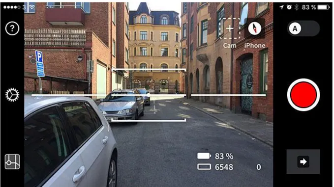
As a direct answer to this dominant aspect of data configuration, open mapping platforms emphasize openness and accessibility. In the case of open street maps, platformization entails democratization, in that the control over the map is more broadly distributed, autonomous and participatory. With accessibility, there are new levels of interactivity and user agency, and the ability for non-experts to participate in maintaining and improving the map (Farman, 2010, p. 872). As a result, vast amounts of data are gathered through new device configurations and strategies that mobilize communities to support a democratic and sustainable use of mapping platforms. For the participating individual, the user-generated map unfolds the lack of a central authorial gaze; that which is represented on the map is acted upon, changed and replaced continuously (p. 880). This ‘freedom’ to change and replace data is made possible through easy-to-use interfaces supported by automated algorithms that greatly reduce the complexity in editing and managing digital maps. The algorithms are programmed to operate with built-in cameras and GPS sensors in mobile devices that ensure the mapper provides reliable map data in the least number of steps, notably in a single-easy click of a button [see Figure 2].
Figure 2 An example of a mobile interface for street level mapping – the red button is the trigger for algorithms to control the use of the camera and the GPS sensor. Image source: http://blog.mapillary.com/img/2017-06-09-start.jpg
Here the question of usability becomes crucial, as it is the operational arm of design that contributes to the development of a just society (Keinonen, 2017). On the one hand, easy to use interfaces make it very convenient for a wide range of individuals to take part in the open street mapping, but on the other hand, the algorithms used to run the interfaces become closely guarded secrets of mapping platforms, despite their claims to openness and accessibility. As a result, the user’s engagement with
the map is reduced to that of being a systemic actuator rather than an ‘inter-actor’ in contributing to the conduct of the processing system. This makes the role of interface designers extremely
challenging as they are expected to solve dissonant needs of users and the businesses through interactivity and usability. In her book Hamlet on the Holodeck, Janet Murray (1997) suggested that the user’s ability to interact is not directly predisposed to the will or act of participation, further that it certainly cannot be reduced to the mere ability of clicking a mouse or moving a joystick (p. 128). Considering this early critique of interactivity, one would expect more from participatory modes of mapping, something that draws upon qualities from recreational mapping activities such as Geocaching, Orienteering or Pokémon Go.
Nonetheless in street-level mapping, there are some qualitative aspects being played out, mainly by incentivising users to be creative and adventurous in exploring urban areas in exchange for open visual map data. In doing so, it motivates the assumption that there is ‘truth’ captured in such experiences, driven by expectations of ‘reality.’ The question then becomes to what extent does street mapping, as a form of combined urban exploration and cartographic servicing, meet the expectations of ‘mappers’ who are configured as agile and humble producers of map data? To answer this question and clarify the underlying assumptions, we contend that exploring the
qualitative aspects of how mapping plays out in specific localized contexts of a user might allow us to discern user experiences potentially at odds with the use and user configuration, or the implicit
ethos, of street mapping platforms.
In the following sections, we describe the methodological framing for attending to the ontological as well as epistemological issues raised here. The framing provides the motivation for the fine-grain, narrative or anecdotal approach, realised through the account of Stig and his experiences of street mapping over a period of 4 months. With this account, we attempt to show how Stig’s engagement with street mapping plays out in otherwise localized, embodied and under-utilized forms. In doing so, we expose weaknesses in the mapping platform for being unable to retain Stig’s long-term engagement with mapping. The goal is to be able to reflect and discuss ethical issues arising out of the platform mind-set on individuals taking part in it.
4 Methodology
Exploring concepts like platformization and its relation to mapping technologies, the aim has been to draw attention to a potential ethical dissonance in the expectations of reliability and efficiency as well as that of participation and emancipation among users. The methodological framing for addressing this condition must attempt to bring a unique sensitivity to capture the situated aspects of individuals taking part in the visions of platformization. Design research holds a long tradition of bringing together widely different disciplines to create shared frameworks of understanding for changing existing realities. While design itself is a future-oriented process and product—not the least as played out in the design of mapping platforms—disciplines like anthropology bring to design the tradition of theorizing concepts like platformization through the context of its usage and its configuration of ‘reality.’ Gunn et al (2013) further propose a ‘design anthropology,’ which is able to “include the critical use of theory and contextualization; the extension of the time horizon to include the past and long-term future to ensure sustainability; and sensitivity to and not least incorporation of the values and perspectives of the people whose worlds are affected by design.” In that, design traditions entailing visual prompts, probes and anecdotal evidences are able to bring rigor into this kind of critically engaged theory and practice through their acknowledgement of non-human agencies, their relationalities and the emergence of new materialities (Lury and Wakeford, 2012). This kind of framing of ‘design anthropology’ thus offers the critical, practical and temporal lenses to adequately address the questions we put forth in the paper.
Relying on this frame, we approached the issue of platformization supported by a ‘design-anthropology’ practice that included inquiries into open mapping platforms and corporate
crucially, the ‘street mappers.’ Based on the interviews conducted with the platform developers, it became evident that the vision for open mapping platforms was to support a large community of mappers to create the ‘best’ photo-representation of the world. This accumulated bulk of open street images are then sold off to corporate enterprises that are in the business of improving the accuracy of self-driving vehicles, while being consolidated for other secondary uses. The
expectations of the platform, in this regard, is to engage as many people as possible to take part in street mapping, as long as they are able to generate a constant flow of data. The retention of individual mappers is thus not a priority for the mapping platform.
For the purpose of developing our argument, we have chosen to present a part of this material through an anecdotal account of Stig, an elderly street mapper, with whom we have conducted a series of interviews over a period of 4 months. Our choice of an anecdotal representation is motivated by an understanding that anecdotes are not mere reflections of research practice but rather they shape how certain events in the research come to be understood. Through the anecdote, the extraordinary event serves to illuminate the ordinary flow of events, allowing for the study of difference and gaps that are deviating from ‘normal’ expectations of reality (Michael, 2012). The account, in this sense, is presented in a manner that can support the aim of exposing the gaps in platformization from an ethical point of view.
5 Stig the street mapper
Stig is an elderly street mapper living in Malmö, the third largest city in Sweden. At the time of conducting this study, he held the second largest contribution of street-level images in Malmö, uploading around 116,000 images and covering 800 km of the city [see Figure 3]. These striking numbers would make one think of Stig as some kind of street mapping specialist, but as we will soon find out, his story is much more layered than what is apparent on the surface.
Figure 3 Screenshot showing Stig’s uploads on the street-mapping platform.
Stig is 69 years old and he is a retired surgeon. He now lives in an elderly home facility in Malmö. As someone who has offered medical service for many years, Stig longs for contributing to society. However, Stig suffers from a disease that has affected his spinal cord, making him entirely
dependent on his rollator walker and mobility scooter to support his daily movements. He otherwise comes across as an independent individual with a youthful spirit for experiencing new cultures, stimulating conversation, and travelling the world.
Stig’s introduction to street mapping occurred by chance at a dinner table conversation. During the dinner, there was a mentioning about street mapping by someone who worked at a firm producing software for street mapping, while advocating for the societal benefits of contributing to a
democratic vision of digital maps. Tickled by curiosity, Stig downloaded the application to his iPhone with some help from them. Stig claimed the application was rather simple to use because all that it demanded of him was to click the ‘automatic capture mode’ button and it took care of everything.
I simply wanted to contribute because I had a lot of fun doing it.
In the beginning, Stig enjoyed mapping so much that he prepared a fix for the left handle of his mobility scooter, which held his iPhone in place for capturing images [see Figure 4]. The fix could move left or right to suit whichever direction he wanted the camera to face. In that, the mobility scooter offered great advantage for capturing ‘non-shaky’ images, which other mappers did not share. Stig was proud of his arrangement and also proud of contributing many images without the trouble of manually operating the iPhone.
Figure 4 Stig’s mobility scooter parked inside his apartment. There is an iPhone rig visible on the left handle of the scooter. Here on we describe different kinds of adaptations Stig undertakes to capture map data, and in doing so, we reflect how this comments on certain weaknesses of the platform, which resulted in Stig’s ultimate withdrawal from street mapping:
Coming from an older generation of users, Stig is not entirely comfortable with new technologies. Nonetheless, as opposed to many of his generational peers, he likes to think that he can use them, and in his possession are one Nokia phone and two iPhones. His primary phone is the Nokia, which he wears in a neck-strap. He calls it his ‘safety phone’ because he has all his emergency contacts saved there. The other phones he sparingly uses them for taking photos or for video chatting with his family. Beyond these basic applications, Stig has difficulty navigating mobile interfaces that requires him to remember a sequence of interaction-flows, such as the procedure for downloading media content from a virtual store or attaching images to an email or a text message. Further, clicking mobile interfaces can be an everyday challenge for Stig, which requires him to find
resourceful fixes for the problem. Stig said he had once carved up a clicking tool from a twig of a tree to ease his burden of clicking. When he is at home, he uses conductive metal ends of pens for interacting with the touchscreen on his iPhone devices. The ease of capturing map data through a single click of a button was ideal for Stig’s use, which in turn portrays him an ideal user of the mapping platform.
According to Stig, he used to map on a routine basis but soon realized that he took the same routes every day to the supermarket, the physiotherapist, or the cinema. This was true because 800 km of Stig’s coverage of Malmö was a recurring chain of photos from the same locations. When Stig raised this issue with the mapping company, he was surprised to learn that images from the same locations greatly improved the accuracy of the map, and he was thus encouraged to continue mapping the same way. To the contrary, Stig decided to reduce his mapping frequency because he did not “feel good” capturing the same locations repeatedly.
When Stig is not out mapping, he is busy with his three translation projects. He claims that carrying out these projects feed his daily dose of intellectual stimulation. The first is an advanced Swedish translation of a Thai recipe book, the second is a translation of a Buddhist meditation book, and his final project is a dictionary translation of ancient Pali language into Swedish. On a regular day, he most looks forward to learning Thai by video chatting with a friend in Thailand.
Viewing someone via Line [video chat application]. Most attractively learning Thai taught by a friend in Thailand.
Stig’s conscious decision to map less frequently highlights how the literal translation activity offered him something more stimulating to do than the repetitive task of capturing the same images on a daily basis. To make mapping interesting, however, Stig tried to increase his breadth of coverage by traveling longer distances of about 20-30 miles from his home. Although he said he was mostly concerned that his scooter would run out of battery if he travelled too far.
I went too far once […] and my scooter ran out of battery. There was nobody on the street, and I called for help. Someone dropped me off at a nearby fuel station where I waited for a couple of hours for the elderly service-bus to pick me up and drop me home. I read magazines and bought some snacks while I waited […] it was embarrassing.
Stig suffers from anxiety over his physical disability. He tries very hard to overcome his anxiety by ensuring the scooter’s battery is charged everyday and that his Nokia phone is strapped around him in case he needed help. Since that incident, Stig chose to make longer trips on mini-buses instead of driving his scooter. It becomes easy to notice how Stig goes out of his way to keep himself engaged in street mapping, even if that meant putting himself in risky situations, ignoring the difficulties in mobilizing himself.
When Stig was asked what he mostly does while mapping, he replied, “nothing, because my
attention is set on the road and my iPhone does the mapping.” He did, however, bring to notice that his attention tends of drift to his iPhone for ensuring the battery lasts the entire mapping activity. Every time he went mapping, Stig connected the iPhone to two power-banks that he put in his backpack, partially closed, in the front basket of the mobility scooter. When he was back home, he needed to recharge all the electronic devices, including his scooter, to make sure he could continue mapping the following day. This was not an easy task, especially for Stig because he struggles to remember things. To this day he maintains a notebook with a list of to-dos. Even then, Stig tends to blame himself, calling his brain “stupid” for not being active any longer.
I am empty in my head. I put everything on paper; I don’t even remember which day it is.
As a countermeasure, Stig exercises his mental capacities by practicing daily meditation. According to him, meditation sharpens his mind’s focus and helps him pay more attention to his daily activities.
I practice Vipassana [insight meditation] for about 30-40 minutes everyday. This style of meditation focuses on abdominal movements. I use a tea light for the atmosphere and close my eyes.
As such, the task of connecting and recharging multiple electronic devices for mapping everyday seems daunting. To that extent, we can notice how Stig consciously tries to adapt himself by
performing remedial practices like meditation to meet everyday demands of maintenance, especially those required of mapping devices.
At the same time, Stig mentioned that he is lonely and craves for meaningful company. On the one hand, the Nokia phone allows him to be as close as possible to his daughters and their families. Stig says his daughters’ families are his closest friends, further claiming he is too old to make new friends. On the other hand, he was very clear that he does not enjoy small talk with his neighbours. Stig attends community events where he socializes, sometimes contributing with vegetarian food. In addition, he volunteers at the city library about once a week, offering Swedish lessons to newcomers in Malmö. Stig enjoys talking to people from other parts of the world and tries to learn their reasons for learning Swedish.
A man from Lebanon once told me how much Swedish he had learned quickly and most of it he could translate to Arabic. He must have made up some of the things he had done, very suspiciously according to me and also some others at SpråkCafé.
Stig’s ‘suspicions’ about this man from Lebanon hints at some of his efforts to find meaningful social interaction as he tries to adapt his daily activities to fulfil this need. Even though it sometimes requires him to speak to complete strangers, he sees it as an opportunity to keep him active and engaged.
With the automated software upgrade on his iPhone, Stig could no longer access the mapping application the same way he did before. According to him, he could not locate the ‘capture’ mode on the application’s interface, which then led him to withdraw from street mapping altogether. He said he did not want to take anyone’s help because he got tired of having to deal with the technology. In his daily life, he dislikes being helped because it puts him in an uneasy relationship with his more ‘abled’ caretakers from the elderly care service. Stig said he sometimes becomes upset when his caretakers do not listen or if they do not engage in his specific needs. He further claimed that he gets depressed just lying in bed every morning until help comes. When he is dressed for the day, Stig prefers to shop and prepare food on his own rather than to depend on his assigned help.
Some [of the caretakers] pretend like they really don’t care.
On an abstract level, the relationship between caregiving and mapping platforms can be explored here. The caretakers in Stig’s everyday life are real and visible with the ability to express his feelings directly to them. With street mapping, on the other hand, there is no one behind the screen with whom Stig could share his needs and difficulties, which eventually led to his frustration. However, one could argue that the reason for Stig’s adoption of street mapping in the first place was because it supported his well-being, as it offered him a kind of physical and mental therapy. The mapping platform can then be seen as a form of care provider, as in Stig’s case, but only within certain limits. This would then beg the question of ‘systemic care’ or the automated configuration of systemic and individual expectations as well as the relationship between the developer and user. Who is caring for whom or what, and to what extent?
5.1
Reflections
The attempts by Stig to engage with street mapping for as long as he could while meeting the demands of maintenance and accuracy of the platform reveals several tensions inherent in its visions to democratize technology and support platformization. The account indicates the
persistence with which Stig met these demands by virtues of compliance and commitment to the mapping activity. In one sense, mapping played a role in offering some therapy and boosting Stig’s confidence and self-worth in society, but it was limited by assumptions that took for granted his mobility and engagement, in spite of the sometimes embarrassing and frustrating situations he encountered while taking part in it. Further, it also shows how his lack of interaction with the technology during mapping was compensated by the task of attending to multiple devices, ensuring they were fully charged and maintained for routine mapping. At the same time, the account brought
to light under-utilized resources in Stig’s life that allowed him to overcome the shortcomings of the mapping technology, where the twig, the ‘safety’ phone, translation activities, social encounters and Buddhist meditation practices began to take more prominent roles in his daily life. In many ways, the problems faced by Stig in street mapping were not entirely his own. They are more telling of the demands placed by the platform on Stig than the weaknesses in him for meeting them. Furthermore, the ‘reality’ in Stig’s experiences while mapping remains unacknowledged and under-represented on the map, thus exposing the complication of platformization behind any claims to systems of care.
6 Discussion
The reflections above highlight some of the hidden gaps in mapping platforms, which shall be discussed here in the light of ethics. In so far, our reading of platformization has drawn attention to the emerging gap in its double agenda of meeting expectations of reliability and efficiency as well as that of participation and emancipation. Following Kitchin (2014), the concern around this kind of platformization is three-fold. First, it promotes the privatization of public services purely
administered for profit making, and second, that it creates ‘technological lock-ins’ that encourage a monopoly of technology platforms for long periods of time, and third, that it gives rise to ‘one-size fits all’ solutions that do not take into account the unique contexts and situations of people,
locations and events (p. 222). Taking these concerns into consideration, the goal is to explore how it plays out for individual users in the context of mapping platforms, highlighting the ways in which map data is made lucrative for big data analytical processes, and further how users of the platform are configured to support such processes.
Through Stig’s account, it becomes clear that his attempts to meet expectations of street mapping came at the cost of his well being, exposing tensions that are ethically problematic. Stig’s withdrawal from street mapping signifies that the platform was not configured for his use, but rather made for a younger generation of users whose code of conduct differs widely from that of Stig’s. For individuals like him, street mapping is less about the pleasures of urban exploration and more inclined to the virtue of meaningfully contributing to a democratic vision of maps. Configuring the user as someone who is only there to seek anticipatory pleasures catered by a single user-experience model thus becomes critical to design of the technology. The single button-click interaction, for instance, reflects this model by enforcing a conduct that supports momentary satisfaction out of urban exploration, while overlooking other forms of conduct, such as Stig’s, that deviate from it. The deviation is played out not only at the interface level, but goes deep into the algorithmic level of conduct. On the one hand, automatizing mapping through closed algorithms that do not take into account local requirements limits the extent to which the user can influence the map. On the other hand, by allowing the user to influence the map freely, it opens up to the risk of polluting existing data sets with meaningless data that cannot be harvested for future uses. The map is thus a complex determination of ‘encoded’ forms of conduct that entails regulatory, prescriptive as well as discriminatory aspects, deeply seated in the algorithms, interactions, user-experience models, and not the least, the business models of the platform.
Another manner of conduct in open mapping platforms is the users’ expectation that the interconnectivities in data reflect their personal influence and continuance for meeting local requirements, but in a way that it does not produce interaction effects leading to secondary uses and targeted feedback. As discussed above, certain interfaces limit the extent to which a user can exert their influence on the data captured, but in other cases, where that is made possible, platforms tend to overpower the user in determining how their data is managed and distributed towards profitable ends. This presents an important ethical gap that draws attention to managing the social expectations of users on platforms. Even though some platforms claim to be open, accessible, and participatory, the extent to which they support the social and relational needs of its users is questionable. The data derived from open data are not driven to support users in meeting their requirements, but are instead transformed into solutions that are technocratic in nature. One
such example discussed earlier is Waze, the smart traffic application, which addresses the specific need of navigating traffic by collecting all possible open data, but without taking into account the actual needs of those producing that data. Open data, in this regard, following Kitchin (2014), are treated more like a product than a service, where the data are simply made available for others to reuse (p. 82). Further, he argues that open data should be more service-oriented by attending to the needs and expectations of the ones who produce the data, the ones who would potentially bear implications for resourcing (p. 82). Achieving such a service-orientation would thus require entering into the narratives of the producers of open data whose social expectations and relational needs may be different from what platform technologies currently offer.
By entering into the narrative of Stig, it becomes possible to imagine what kind of individual he is, why he participates in open data initiatives such as street mapping, and further what expectations he might have for open mapping platforms that could support his needs. The seriousness of his participation in street mapping must therefore not be taken lightly. Furthermore, his adaptations in the form of meditation and literal translation produced ‘reality effects’ that made his experiences of mapping more real than what the map represents. Reality effects, in this regard, comment on the expectations of reality in mapping platforms that go much deeper than a simple digital trace on the map. These effects point to both the weaknesses of the mapping platform in failing to pay attention to those details in his life as well as the opportunity to understand the context of Stig’s social and relational needs. In this sense, studying how these reality effects play out in the production of data by different individuals becomes crucial from an ethical point of view.
In addition to studying the effects of open mapping platforms, there could be other directions to consider for further development. For instance, open data in platforms could open up to the possibility for collaborative learning to take place where people learn to use the data as a shared resource to meet social needs. Feminist-geographer duo Gibson-Graham (2008, p. 15), for instance, argue that collective experimentation can potentially foster relations of interdependence that are democratically negotiated by participating individuals and organisations. Yet one needs to consider that open data is not a sound resource for gathering reliable data, leading to potential misgivings in regards to accountability and robustness. This is because open data does not necessarily have a formal structure or easily identifiable fields that are regularly maintained for harvesting and use. Kitchin (2014, p. 82) argues that even if the prospect of delivering open data as a service is
agreeable, in practice it might entail a long chase for effective funding opportunities to support such initiatives. Nevertheless, these shortcomings can be potentially met in ways that are inspired by alternative modes of production based on mutual care (see Gibson-Graham, 2008). To that extent, even the open mapping platform can be seen as a way to provide mutual care, such as in the case of Stig, through his specific mis-adoption of the platform for his therapeutic needs, albeit in a limited sense and for a short period of time. It would then require further work for exploring not just how different models of care can be brought into service-based platform-systems, but also how to facilitate patterns of interaction beyond the instantaneous button level of satisfaction and support mutual learning and long(er)-term retention of the user as acknowledged participant.
7 Conclusion
The aim of this paper was not to provide a clear answer to the question of what design should do with the issues raised but rather to open up the complexity in the relations between platforms and users and to draw attention to the ethical dissonances that arise from them in their local contexts of use. The paper started out with the example of the application ‘Waze’ stating how many technology platforms operate with good intentions even though it is difficult for the involved actors to foresee how the technology will play out in the short and long term. Through the logic of platformization, we argued that it is not the intentions per se but rather the gap in expectations between that of driving ‘efficiency’ through users and the social expectations on platforms to resolve complex societal issues that becomes ethically problematic. These gaps in expectations were discussed in the context of
open mapping platforms. With the help of concepts such as ‘ethical interaction effects’, we raised the implications arising out of contingent aspects of big data and its use-configurations, and how these aspects are implicated in the way the open mapping platforms operate their usability
strategies to produce as much data as possible from a large group of users. We acknowledge how it is made especially difficult for designers to cater to the needs of end-users, while contending with dominant regulatory aspects and the closed nature of business models.
We presented an account of an elderly street mapper, Stig, to understand how an individual like him fares in his attempts to be a ‘good’ data producer for open mapping platforms. The narrative
describes his experiences of having to come to terms with his own ‘differences’ that are at odds with the anticipated user-experience delivered by mapping application. The account ends with Stig’s withdrawal from street mapping, drawing attention to the adaptations he makes during his mapping to support his well being as well as meeting his needs for meaningful interaction. We believe these aspects are a part of a bigger ethical problem that is deeply set in the logic of platformization. By opening up to this condition, what kind of questions should we be asking as design researchers? In our discussion, we expose the deviations taking place in the conduct of the mapping platform starting from the level of the user-experience model, and right down to the interface and code level of the platform. Describing the manifestation of such deviations as ‘encoded’ forms of conduct, we acknowledge their inevitability as well as their potential for negative consequences. One direction for interaction designers is to find alternate ways of ‘encoding’ different kinds of conduct into the use of the platform that might reduce deviations for end-users. To do so, we argue the need for designers to enter into the narratives of the individuals who produce data for platforms. Exploring the ‘reality effects’ in the narratives would then allow designers to understand the contexts of the social and relational needs of the data producers. We see this as being a valuable step towards addressing the gap in expectations. Furthermore, we also acknowledge the potential for new conceptualisations, other than platformization, using open data as a resource. Undertaking feminist perspectives, we question the need for bringing into consideration alternative modes of production that are based on notions of care-giving and mutual learning. The question for designers is then whether to continue solving the dissonant expectations inherent in platformization or to explore radically new uses for open data in ways that allow the desired changes to happen.
8 References
Beer, D. (2009). Power through the Algorithm? Participatory Web Cultures and the Technological Unconscious. New Media & Society 11(6): 985–1002.
Dutton, W. (2014). Putting things to work: social and policy challenges for the Internet of things. info, 16(3), 1-21.
Farman, J. (2010) Mapping the Digital Empire: Google Earth and the Process of Postmodern Cartography. New Media & Society 12(6): 869–888.
Featherstone, M. (2009). Ubiquitous media: an introduction. Theory, Culture & Society, 26(2-3), 1-22. Gibson-Graham, J. K. (2008). Diverse economies: performative practices forother worlds'. Progress in Human
Geography, 32(5), 613-632.
Gunn, W., Otto, T., & Smith, R. C. (Eds.). (2013). Design anthropology: theory and practice. A&C Black.
Hayles, N. K. (2009). RFID: Human agency and meaning in information-intensive environments. Theory, Culture
& Society, 26(2-3), 47-72.
Helmond, A. (2015). The platformization of the web: Making web data platform ready. Social Media +
Society , 1 (2), 2056305115603080.
Jucevičius, Robertas, Irena Patašienė, and Martynas Patašius 2014 Digital Dimension of Smart City: Critical Analysis. Procedia - Social and Behavioral Sciences 156 (Supplement C). 19th International Scientific Conference “Economics and Management 2014 (ICEM-2014)”: 146–150.
Keinonen, T. (2017). Designers, Users and Justice. Bloomsbury Publishing.
Kitchin, R. (2014). The data revolution: Big data, open data, data infrastructures and their consequences. Sage. Kuijer, L., Nicenboim, I., & Giaccardi, E. (2017, June). Conceptualising Resourcefulness as a Dispersed Practice.
Lury, C., & Wakeford, N. (Eds.). (2012). Inventive methods: The happening of the social. Routledge. Mantelero, A. (2016). Personal data for decisional purposes in the age of analytics: From an individual to a
collective dimension of data protection. Computer law & security review, 32(2), 238-255. Michael, M. (2012). 2 Anecdote. Inventive methods: The happening of the social, 25.
Murray, J. H. (2017). Hamlet on the holodeck: The future of narrative in cyberspace. MIT press. O'Leary, D. E. (2016). Ethics for Big Data and Analytics. IEEE Intelligent Systems, 31(4), 81-84.
Perboli, Guido, Alberto De Marco, Francesca Perfetti, and Matteo Marone (2014). A New Taxonomy of Smart City Projects. Transportation Research Procedia 3(Supplement C). 17th Meeting of the EURO Working Group on Transportation, EWGT2014, 2-4 July 2014, Sevilla, Spain: 470–478.
Santos, B. de Sousa. (2004). The world social forum: toward a counter-hegemonic globalisation (part I). In World Social Forum: Challenging Empires (pp. 235-245). New Delhi: The Viveka Foundation. Traffic-Weary Homeowners and Waze Are at War, Again. Guess Who’s Winning? - The Washington Post N.d. https://tinyurl.com/yauucr8q
About the Authors:
Anuradha Reddy is a PhD candidate in Interaction Design from Malmö University.
Her research focuses on non-traditional explorations of IoT-based domestic technologies using participatory interaction design methods and frameworks through the lens of care and critical theory.
Maria Hellström Reimer is a professor in Design Theory at Malmö University, School
of Arts and Communication. Her research is interdisciplinary, concerning aesthetics and politics, urbanism and activism, including questions of climate transition and processes of social change.