ACROSS- AND ALONG-STRIKE STRUCTURAL AND GEOCHRONOLOGICAL VARIATIONS OF THE NASHOBA-PUTNAM AND AVALON TERRANES,
EASTERN MASSACHUSETTS, CONNECTICUT, AND RHODE ISLAND, SOUTHEASTERN NEW ENGLAND
APPALACHIANS
by
Copyright by Allison R. Severson 2020 All Rights Reserved
ii
A thesis submitted to the Faculty and the Board of Trustees of the Colorado School of Mines in partial fulfillment of the requirements for the degree of Doctor of Philosophy (Geology).
Golden, Colorado Date ______________________ Signed: _____________________________ Allison R. Severson Signed: _____________________________ Dr. Yvette D. Kuiper Thesis Advisor Golden, Colorado Date ______________________ Signed: _____________________________ Dr. Wendy A. Bohrson Professor and Department Head Department of Geology and Geological Engineering
iii ABSTRACT
A comprehensive structural and geochronologic investigation was combined with existing structural, geochronologic and geophysical data to characterize and interpret across- and along-strike variations associated with the last two major orogenic events that formed the southeastern New England Appalachians of eastern North America. These orogenies are the mid-Paleozoic Acadian orogeny and the late Paleozoic Alleghanian orogeny. The northeast-trending Nashoba-Putnam terrane, located in eastern Massachusetts and Connecticut is part of the Gondwanan-derived microcontinent Ganderia. It is in fault contact with greenschist facies rocks of the Merrimack belt to the west, and with generally low grade rocks of the Avalon terrane to the east. Structural data in the Nashoba-Putnam terrane show five generations of deformation. Structural and metamorphic data are generally consistent with a channel flow model, where a hot, viscous mid- to lower crustal layer flows between relatively cool and more rigid layers, to remove material laterally in an overthickened orogenic belt. The occurrence of contemporaneous localized sinistral movement in schist and distributed dip-slip movement in migmatitic gneiss may represent strain partitioning of lateral movement and ductile extrusion of the channel in a sinistral transpressional regime. Based on new and existing U-Pb geochronology data, ductile deformation and possibly channel flow occurred during the latest Silurian to earliest Carboniferous Acadian orogeny, which resulted from the accretion of the Avalon terrane.
Foliation orientations in the northwest-dipping Nashoba-Putnam terrane show a decrease in dip angle from subvertical and moderate dips in the north to moderate and shallow dips in the south, changing in particular at the latitude of Boston, Massachusetts. Furthermore, localized zones of west-trending foliation and west-trending terrane boundary between the Nashoba-Putnam and Avalon terranes occur along the generally northeast-trending foliations and boundary. One of these zones occurs at the latitude on Boston, at the same latitude as the transition from steeper to shallower dipping foliations.
The Avalon terrane in southeastern New England is a composite terrane that rifted from Gondwana in the Ordovician and accreted to Laurentia during the Acadian orogeny. U-Pb and Lu-Hf isotopic analyses of zircon in three sedimentary rocks in the western-most Avalon terrane in southeastern New England was carried out to compare the detrital zircon signature with those of
iv
other metasedimentary rocks of the southeastern New England Avalon terrane and with Avalonia in eastern Canada. Analyzed samples are isotopically similar to others in the New England Avalon terrane, and to Avalonia in Canada, especially the Gamble Brook Formation in the northern part of Nova Scotia. Finally, detrital zircon of the western Avalon terrane has a mixed source between Baltica and Amazonia.
U-Pb analyses of zircon from migmatitic rocks in the southeastern Nashoba terrane, combined with existing 40Ar/39Ar and U-Pb analyses of high temperature minerals suggest a younging of leucosome and high-grade metamorphism from north to south in the Nashoba-Putnam and Avalon terranes. The major transition in ages of leucosome occurs at the approximate latitude of Boston, Massachusetts. Furthermore, west-trending lineaments and a gravity anomaly are visible in aeromagnetic and Bouguer gravity datasets, respectively. The most notable of these west-trending lineaments is located along the latitude of Boston, Massachusetts. This lineament coincides with a change in foliation orientations as outlined above. Furthermore, U-Pb monazite ages along this lineament are late Paleozoic in the Nashoba terrane. In the Avalon terrane, a transition occurs from predominantly middle Paleozoic 40Ar/39Ar hornblende cooling ages relating to the Acadian orogeny to the north and mostly late Paleozoic ages relating to the Alleghanian orogeny to the south. This lineament is therefore interpreted as the ‘Alleghanian Front’, where rocks to the south were affected by the Alleghanian orogeny, while rocks to the north show only minor effects.
v TABLE OF CONTENTS ABSTRACT ... iii LIST OF FIGURES ... ix LIST OF TABLES ... xi ACKNOWLEDGEMENTS ... xii CHAPTER 1 INTRODUCTION ... 1 1.1 Research goal ... 1
1.2 General background of the southeastern New England Appalachians ... 1
1.3 Thesis methods... 6
1.4 Thesis organization ... 6
1.5 References ... 7
CHAPTER 2 THE STRUCTURAL HISTORY OF THE NASHOBA-PUTNAM TERRANE, SOUTHEASTERN NEW ENGLAND – AN EXAMPLE OF CHANNEL FLOW? ... 12 2.1 Introduction ... 13 2.2 Background ... 14 2.2.1 Tectonic background ... 14 2.2.2 Geologic background ... 16 2.2.3 Structural background ... 22
2.2.4 Channel flow model ... 23
2.3 Methods... 25
2.4 Results ... 27
2.5 Discussion ... 32
2.5.1 Deformation events in the Nashoba-Putnam terrane ... 32
2.5.2 Structural domains within the Nashoba-Putnam terrane ... 34
vi
2.5.2.2 Southeastern Nashoba terrane structural domain ... 34
2.5.2.3 Putnam terrane structural domain ... 35
2.5.2.4 Summary of structural domains ... 35
2.5.2.5 Along-strike terrane-scale structural trends ... 35
2.5.3 The Nashoba-Putnam terrane – a channel flow model? ... 36
2.5.4 Channel flow in a transpressional regime? ... 42
2.6 Conclusions ... 43
2.7 Acknowledgements ... 45
2.8 References ... 45
CHAPTER 3 NEW U-PB DETRITAL ZIRCON AGES AND LU-HF ISOTOPIC DATA FROM METASEDIMENTARY ROCKS ALONG THE WESTERN-MOST BOUNDARY OF THE “COMPOSITE” AVALON TERRANE IN THE SOUTHEASTERN NEW ENGLAND APPALACHIANS ... 53
3.1 Purpose of Study ... 55 3.2 Geologic Background ... 55 3.3 Methods... 58 3.3.1 U-Pb ... 58 3.3.2 Lu-Hf ... 60 3.4 Results ... 61
3.4.1 U-Pb and Lu-Hf detrital zircon results ... 61
3.4.1.1 Westboro Quartzite - MAS-159 ... 61
3.4.1.2 Plainfield Formation - MAS-177 ... 62
3.4.1.3 Plainfield Formation - MAS-170 ... 65
3.5 Discussion ... 65
vii
3.5.2 Hf isotope tectonic provenance comparisons ... 71
3.5.2.1 Avalon terrane vs. Avalonia ... 71
3.5.2.2 Avalon terrane vs. potential cratonic sources ... 72
3.6 Conclusions ... 76
3.7 Acknowledgements ... 77
3.8 References ... 77
CHAPTER 4 THE ALLEGHANIAN FRONT IN THE SOUTHEASTERN NEW ENGLAND APPALACHIANS: A COMPREHENSIVE ANALYSIS OF U-PB, 40AR/39AR, K/AR, AND AEROMAGNETIC AND GRAVITY ANOMALY DATA ... 84
4.1 Introduction ... 85
4.2 Geologic and tectonic background ... 86
4.2.1 Northern Appalachian tectonic overview ... 86
4.2.2 Geology of the Nashoba-Putnam terrane ... 88
4.2.3 Geology of the Avalon terrane ... 92
4.3 Methods... 93
4.3.1 U-Pb SHRIMP-RG zircon sample preparation ... 93
4.3.2 SHRIMP analysis ... 96
4.4 Results ... 96
4.4.1 MAS-052 – partially melted Shawsheen Gneiss ... 99
4.4.2 MAS-107 – partially melted Marlboro Formation ... 100
4.4.3 MAS-136d – Phantom Dike ... 102
4.5 Discussion ... 104
4.5.1 Shawsheen Gneiss (MAS-052) ... 104
viii
4.5.3 Phantom dike (MAS-136d) ... 106
4.5.4 Compiled geochronological and geophysical studies in southeastern New England ... 106
4.5.5 Tectonic interpretation ... 113
4.6 Conclusion ... 114
4.7 Acknowledgements ... 115
4.8 References ... 115
CHAPTER 5 GENERAL CONCLUSIONS ... 124
5.1 Structural analyses and geochronological compilation within the Nashoba-Putnam terrane (Chapter 2) ... 124
5.2 U-Pb and Lu-Hf isotopic investigations of detrital zircon in the western-most Avalon terrane in southeastern New England (Chapter 3) ... 125
5.3 U-Pb analysis of migmatitic rocks in the southeastern Nashoba terrane; compilation of U-Pb, Ar-Ar, aeromagnetic, and Bouguer gravity datasets to determine age(s) of partial melt and high-grade metamorphism in the Nashoba-Putnam terrane (Chapter 4) ... 126
5.4 References ... 127
ix
LIST OF FIGURES
Figure 1.1. Lithotectonic map of the northern Appalachians ...2
Figure 1.2. Map of tectonic terranes in southeastern New England, and geology of the Nashoba-Putnam terrane ...3
Figure 1.3. Geologic map of the composite Avalon terrane in southeastern New England ...5
Figure 2.1. Lithotectonic map of the northern Appalachians ...15
Figure 2.2. Map of tectonic terranes in southeastern New England...17
Figure 2.3. Generalized geologic and structural map of the Nashoba terrane ...18
Figure 2.4. Generalized geologic and structural map of the Putnam terrane ...21
Figure 2.5. Schematic cross section of an example of channel flow in the Himalayas ...25
Figure 2.6. Equal-area lower-hemisphere projections: northwestern Nashoba terrane, southeastern Nashoba terrane, and Putnam terrane ...26
Figure 2.7. Field photos of structures throughout the Nashoba-Putnam terrane ...29
Figure 2.8. Schematic block diagram of deformation in the Nashoba-Putnam terrane ...31
Figure 2.9. Schematic cross section through the Merrimack belt, Nashoba-Putnam terrane, and Avalon terrane ...39
Figure 3.1. Lithotectonic map of the northern Appalachians ...56
Figure 3.2. Detailed geologic map of the New England Avalon terrane ...59
Figure 3.3. Relative probability plot; Wetherill Concordia diagram ...63
Figure 3.4. εHf against U-Pb age of detrital zircons ...64
Figure 3.5. Normalized probability diagrams for detrital zircon samples discussed for the New England Avalon terrane and Avalonia in Canada. ...67
Figure 3.6. Normalized probability diagrams (>700 Ma only) of detrital zircon samples discussed in this study. ...68
Figure 3.7. A comparison of Hafnium data from this study plotted over outlines of Hafnium data from Avalonia in Canada ...72
x
Figure 3.8. A comparison of Hafnium data from this study plotted over outlines of
Hafnium data from Amazonia ...73 Figure 3.9. A comparison of Hafnium data from this study plotted over outlines of
Hafnium data from Baltica...74 Figure 3.10. A comparison of Hafnium data from this study plotted over outlines of
Hafnium data from the West African Craton ...75 Figure 4.1. Lithotectonic map of the northern Appalachians ...87 Figure 4.2. Geologic map of the Nashoba-Putnam terrane in the southern-most New
England Appalachians ...89 Figure 4.3. Outcrop images of rocks sampled for U-Pb SHRIMP-RG analysis of zircon
grains ...94 Figure 4.4. Representative zircon grains from three samples analyzed by SHRIMP-RG ...97 Figure 4.5. Tera-Wasserburg plots and weighted mean plot with ages ...98 Figure 4.6. Th/U value plotted against age for analyzed zircon grains from a migmatitic
sample from the Shawsheen Gneiss ...100 Figure 4.7. Th/U value plotted against age for analyzed zircon grains from migmatitic
sample from the Marlboro Formation……… ..102 Figure 4.8. Th/U value against age for analyzed zircon grains from granitic dike that
crosscuts the Marlboro Formation ...103 Figure 4.9. Compiled U-Pb, Ar-Ar, and K-Ar data ...108 Figure 4.10. Compiled 40Ar/39Ar hornblende cooling ages, and U-Pb zircon, monazite,
and titanite ages representing high-grade metamorphism and partial melt ...110 Figure 4.11. Geophysical datasets collected in southeastern New England ...111
xi
LIST OF TABLES
Table 2.1. Structural and geochronological events of rocks in the northwestern and southeastern Nashoba terrane. 1Electron Microprobe Analyses; 2Chemical
Abrasion Thermal Ionization Mass Spectrometry. ... 24 Table 2.2. Characteristics of the channel flow model with references, and observations
made in the Nashoba-Putnam terrane. *Indicative of ductile extrusion rather than channel flow. While late normal shear isn’t associated with channel flow, it still has implications for exhumation of a huge mountain belt. ... 37 Table 2.3. A summary of the crystallization age of major intrusive rocks of the
xii
ACKNOWLEDGEMENTS
There are so many folks I would like to thank for their support along this journey. To my advisor and mentor (and future collaborator and friend), Yvette, for her extensive knowledge, encouragement, and unwavering support through everything in research and in life. My parents for their continuous support over the years. Perhaps more importantly, for subtly pushing me into their field of the earth sciences and instilling in me a love for the outdoors, and eventually for the rocks that make up those gorgeous views we would hike to during our many summer travels west. Thanks and apologies to my sister April for her honesty and patience with the family during our many geology-related discussions, and for always pushing me forward. I would like to thank my Wasatch-Uinta Field Camp crew for being my home away from home, for rekindling my passion for teaching every summer in Park City, and for our many spirited discussions over many a late evening. To my closest friend Sharkie for her continued support in-person and over the phone, and for our many late work nights while multitasking and supporting local establishments.
To my accountabilibuddies, Kuiper KATS research group, roommates, and office-mates for their near-infinite discussions (science and worldly), support, and funtivities. “If you want to go fast, go alone. If you want to go far, go together.” –African proverb
1 CHAPTER 1
INTRODUCTION
In this chapter, first, the overall goal of this thesis is defined. Then, a brief synopsis of the tectonic and geologic history of the southeastern New England Appalachians is provided. Next, the appropriate methods/analyses carried out to achieve the research goal are listed. Finally, the organization of the thesis is outlined.
1.1 Research goal
The main objective of this project was to collect and interpret structural field data and various geochronological analyses to characterize across-strike and along-strike variations within the Nashoba-Putnam terrane, and Avalon terrane, in southeastern New England, at the southernmost extent of the northern Appalachians (Figure 1.1). New and existing data were compared with existing geophysical data.
1.2 General background of the southeastern New England Appalachians
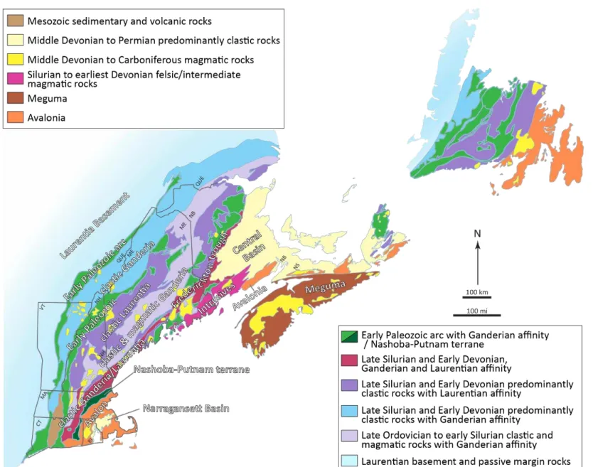
Microcontinents that were rifted from Gondwana in the Cambrian to Ordovician such as Ganderia and Avalonia (Hibbard et al., 2006; Nance et al., 2008; Murphy et al., 2009; van Staal et al., 2009; Hatcher, 2010), eventually accreted to Laurentia. The Nashoba-Putnam terrane along the trailing edge of Ganderia, and the southeastern New England Avalon terrane (in this thesis simply called Avalon terrane), which is interpreted as part of Avalonia as exposed in Canada, are now located in eastern Massachusetts, Connecticut, and Rhode Island, and form the focus of this study (Figure 2A).
The Nashoba-Putnam terrane comprises sedimentary, mafic and felsic volcanic and volcaniclastic rocks (Figure 1.2B) (Bell and Alvord, 1976; Goldsmith et al., 1991; Hepburn et al., 1995). It formed in an arc/backarc complex (Goldsmith, 1991; Hepburn et al., 1995, 2014; Kay et al., 2017). It has Ganderian affinity based on U-Pb detrital zircon and Sm-Nd geochemical analyses (Loan, 2011; Kay et al., 2017). These rocks were later multiply deformed and metamorphosed to upper amphibolite facies conditions with local evidence for partial melt during the middle Paleozoic Acadian orogeny. Intermediate and felsic rocks intruded the metamorphosed rocks in the latest
2
Silurian, Devonian, and Early Carboniferous (Figure 1.2B) (Castle, 1976; Zartman and Naylor, 1984; Hepburn et al., 1995, and others). The deformation history and partial melt histories of the northwestern Nashoba terrane associated with the middle Paleozoic Acadian orogeny have been studied in detail (Buchanan et al., 2014a, b, 2015a, b, 2016a, b; 2017). Northwest-side-down folding occurred in migmatitic gneiss (Buchanan et al., 2014b), while shear fabrics in localized schist zones show synchronous sinistral deformation (Buchanan et al., 2016b, 2017). These are crosscut by younger subvertical shear zones that have normal movement (Buchanan et al., 2016b, 2017). The northwest-dipping Nashoba-Putnam terrane is fault-bounded against greenschist facies rocks of the Merrimack belt to the northwest, and the Avalon terrane to the southeast. The first goal of this study was to test how high grade rocks of the Nashoba-Putnam terrane were emplaced between lower grade rocks.
The Avalon terrane contains numerous rock units that are difficult to correlate, which have led to the interpretation that it is a composite terrane (Rast and Skehan, 1990, 1993; Skehan and Rast, 1990). It is composed of Ediacaran to Ordovician metasedimentary, igneous, and volcanic rocks (Figure 1.3) (Zartman and Naylor, 1984; Thompson et al., 1996). Sedimentary rocks are at the base of the sequence and were deposited in a passive margin to active margin setting (Bell and Alvord, 1976; Goldsmith, 1991). Sedimentary rocks were then overlain by mafic metavolcanic rocks that grade upward into felsic metavolcanic rocks (Goldsmith, 1991). This sequence was later metamorphosed to quartzite, schist, calc-silicate, amphibolite, and gneiss under increasing metamorphic conditions (Figure 1.3) (Perry and Emerson, 1903; Hepburn and DiNitto, 1978; Goldsmith, 1991). The northern Avalon terrane was metamorphosed to lower greenschist facies conditions with local lower amphibolite facies conditions; the southern Avalon terrane was metamorphosed to upper amphibolite facies conditions (Wintsch et al., 1992). Two previous U-Pb detrital zircon studies of sedimentary units of the northern Avalon terrane yielded Ediacaran (Hepburn et al., 2008) and Tonian maximum depositional ages (Thompson et al., 2012). Based on rock types and previous isotopic studies of sedimentary units in the New England Avalon terrane, some correlations have been made between some units and those in Avalonia in Canada (Figure 1.1) (Keppie et al., 1998; Barr et al., 2003, 2019, Murphy et al., 2004; Pollock et al., 2009; Satkoski et al., 2010; Thompson et al., 2012). A second goal of this study was to make better correlations between the New England Avalon terrane and other parts of Avalonia, but also between units along the northwestern margin of the New England Avalon terrane.
3
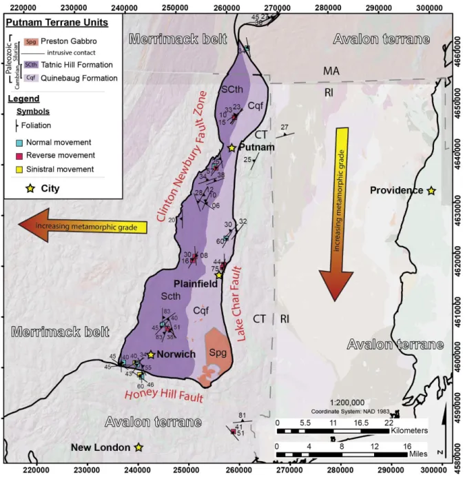
Figure 1.2. Map of (A) tectonic terranes in southeastern New England, and (B) geology of the Nashoba-Putnam terrane. Modified from Zen et al. (1983), Rodgers (1985), Hepburn et al. (1995), Hibbard et al. (2006), and Wintsch et al. (2014). MA – Massachusetts; CT – Connecticut, RI – Rhode Island; CNFZ – Clinton-Newbury Fault Zone; BMZ – Burlington Mylonite Zone; LCF – Lake Char Fault; HHF – Honey Hill Fault.
Figure 1.3. Geologic map of the composite Avalon terrane in southeastern New England. Modified from Goldsmith (1991) and Thompson et al. (2012).
The Avalon terrane is in fault contact with the Nashoba-Putnam terrane to the northwest (Figure 1.2A). The timing of accretion of the composite Avalon terrane to Ganderia is controversial. In northeastern Massachusetts, U-Pb and 40Ar/39Ar data suggest that accretion occurred during the middle Paleozoic Acadian orogeny (Skehan and Rast, 1990; Hepburn et al., 1995; Keppie et al., 1998; Dorais et al., 2001), while in Connecticut they suggest juxtaposition of the terranes during the late Paleozoic Alleghanian orogeny (Wintsch et al., 1992, 2007, 2014). The third part of this study focused on resolving this controversy, and on along-strike changes in ages of deformation and metamorphism in both the Nashoba-Putnam and Avalon terranes in general. 1.3 Thesis methods
In this study, the following analyses were carried out to achieve the research objective(s) of this thesis:
Field work and structural analyses (using equal-area lower-hemisphere projections) to create a geologic map and characterize deformation events and across- and along-strike variations in deformation history in the Nashoba-Putnam terrane,
U-Pb and Lu-Hf detrital zircon analysis of three metasedimentary rocks in the western-most Avalon terrane in southeastern New England, and comparison of data with those from Avalonian samples in Canada to improve correlations determine sediment source(s) along-strike,
U-Pb Sensitive High Resolution Ion Microbe zircon analysis to determine the age(s) of partial melt and high-grade metamorphism in the Nashoba terrane,
Compilation of 40Ar/39Ar, U-Pb, aeromagnetic, and Bouguer gravity anomaly datasets from the southeastern New England Appalachians to identify relationships between them and interpret their tectonic significance determine the ages of partial melt and high-grade metamorphism.
1.4 Thesis organization
Subsequent to this chapter are three manuscripts (Chapters 2–4) to be submitted to journals for publication. Chapter 2 outlines the structural history of the Nashoba-Putnam terrane and will be submitted to the Journal of Structural Geology. Chapter 3 is a manuscript that focuses on U-Pb and Lu-Hf isotopic signatures of detrital zircon analyses from quartzite units in the western-most
Avalon terrane in the southeastern New England Appalachians to determine if these samples are comparable to Avalonia in Canadian, and to determine the potential source of detritus for the Avalon terrane. This manuscript will be submitted to a Geological Society of America Special Paper, titled, “New developments in the Appalachian-Caledonian-Variscan orogen.” Chapter 4 discusses U-Pb SHRIMP-RG analyses of zircon grains in migmatitic rocks to determine the range(s) of partial melt in the Nashoba-Putnam terrane. This chapter includes a compilation study of 40Ar/39Ar hornblende cooling ages, U-Pb high-temperature ages that represent partial melt and metamorphism, and several geophysical datasets covering southeastern New England in an attempt to characterize the high-temperature history of the southeastern New England Appalachians. This manuscript will be submitted to Geochemistry, Geophysics, and Geosystems (G3). Chapter 5 summarizes the outcome of all three projects.
1.5 References
Barr, S.M., Davis, D.W., Kamo, S., White, C.E., 2003, Significance of U-Pb detrital zircon ages in quartzite from peri-Gondwanan terranes, New Brunswick and Nova Scotia, Canada. Precambrian Research, v. 126, pp. 123–145.
Barr, S.M., van Rooyen, D., Miller, B.V., White, C.E., Johnson, S.C., 2019, Detrital zircon signatures in Precambrian and Paleozoic sedimentary units in Ganderia and Avalonia of southern New Brunswick, Canada – more pieces of the puzzle. Atlantic Geology, v. 55, pp. 275–322.
Bell, K.G., Alvord, D.C., 1976, Pre-Silurian stratigraphy of northeastern Massachusetts. Geological Society of America Memoir 148, pp. 179–216.
Buchanan, J.W., Kuiper, Y.D., Buchwaldt, R., 2014a, Constraining the timing of deformation in the Nashoba Formation, eastern Massachusetts: A Structural and Geochronological Study. Geological Society of America, Abstracts with Programs, v. 46, no. 2, pp. 122. Buchanan, J.W., Kuiper, Y.D., Buchwaldt, R., 2014b, Timing and style of deformation in the Nashoba Formation of the Nashoba terrane, eastern Massachusetts. Structural Geology and Tectonics Forum 3rd biennial meeting (16-18 June), Golden, CO.
Buchanan, J.W., Kuiper, Y.D., Buchwaldt, R., 2015a, New advances on the deformation and anatectic history of the Nashoba terrane, New England Appalachians. Geological Society of America, Abstracts with Programs, v. 47, no. 7, pp. 862.
Buchanan, J.W., Kuiper, Y.D., Kelly, N.M., 2015b, Preliminary metamorphic history of the Nashoba Formation, eastern Massachusetts. Geological Society of America, Abstracts with Programs, v. 47, no. 2, pp. 92.
Buchanan, J.W., Kuiper, Y.D., Hepburn, J.C., Kelly, N.M., 2016a, Linking partial melting in the Nashoba Formation to the Andover Granite, eastern Massachusetts. Geological Society of America, Abstracts with Programs, v. 48, no. 2, 43-3.
Buchanan, J.W., Kuiper, Y.D., Williams, M.L., Hepburn, J.C., 2016b, Ductile extrusion of the Nashoba Formation during convergence of the Avalon terrane with the composite
Laurentian margin, eastern Massachusetts. Geological Society of America, Abstracts with Programs, Vol. 47, No. 7.
Buchanan, J.W., Kuiper, Y.D., Williams, M.L., Hepburn, J.C., 2017, Constraints on Devonian-Carboniferous deformation in the Nashoba terrane, eastern Massachusetts. Geological Society of America, Abstracts with Programs, Vol. 49, No. 2.
Bell, K.G., Alvord, D.C., 1976. Pre-Silurian stratigraphy of northeastern Massachusetts. Geological Society of America Memoir 148, pp. 179–216.
Castle, R.O., Dixon, J.R., Grew, E.S., Griscome, A., and Zietz, I., 1976, Structural dislocations in eastern Massachuestts. United States Geological Survey, Bulletin 1410, 39 p.
Dorais, M.J., Wintsch, R.P., Becker, H., 2001, The Massabesic Gneiss Complex, New Hampshire: a study of a portion of the Avalon terrane. American Journal of Science, v. 301, pp. 657– 682.
Goldsmith, R., 1991a. Stratigraphy of the Nashoba zone, eastern Massachusetts: an enigmatic terrane. In: Hatch, N.L., Jr., ed., The bedrock geology of Massachusetts. United States Geological Survey Professional Paper 1366E–J, pp. F1–F22.
Goldsmith, R., 1991b. Stratigraphy of the Milford-Dedham Zone, eastern Massachusetts: an Avalonian terrane. In: Hatch, N.L., Jr., ed., The bedrock geology of Massachusetts. United States Geological Survey Professional Paper 1366E-J, pp. E1–E62.
Hatcher, R.D., 2010. The Appalachian orogen: A brief summary: In: Tollo, R.P., Bartholomew, M.J., Hibbard, J.P., and Karabinos, P.M., eds., From Rodinia to Pangea: The Lithotectonic Record of the Appalachian Region. Geological Society of America Memoir, v. 206, pp. 1– 19.
Hepburn, J.C. DiNitto, R.G., 1978, Preliminary bedrock geologic map of the Marlborough quadrangle, Middlesex and Worcester Counties, Massachusetts: U.S. Geological Survey Open-File Report 78-222, v. 29, p.1, scale 1:24,000.
Hepburn, J.C., Dunning, G.R., Hon, R., 1995. Geochronology and regional tectonic implications of Silurian deformation in the Nashoba terrane, southeastern New England, U.S.A, in Hibbard, J.P., van Staal, C.R., and Cawood, P.A. eds., Current Perspectives in the Appalachian-Caledonian Orogen: Geological Association of Canada Special Paper 41, pp. 349–366.
Hepburn, J.C., Kuiper, Y.D., Buchanan, J.W., Kay, A., Dabrowski, D.R., 2014. Evolution of the Nashoba terrane, an early Paleozoic Ganderian arc remnant in eastern Massachusetts, in Thompson, M.D. ed., Guidebook for Field Trips in Southeastern New England (MA-NH-RI), 106th New England Intercollegiate Geological Conference, Wellesley College, Wellesley, Massachusetts, Field Trip B3, 19 pp.
Hibbard, J.P., van Staal, C.R., Rankin, D., Williams, H., 2006, Lithotectonic map of the Appalachian orogen (north), Canada–United States of America. Geological Survey of Canada Map 02041A, scale 1:1,500,000, 1 sheet.
Kay, A., Hepburn, J.C., Kuiper, Y.D., Baxter, E.F., 2017. Geochemical evidence for a Ganderian arc-back-arc remnant in the Nashoba Terrane, SE New England, USA. American Journal of Science, v. 317, pp. 413–448.
Keppie, J.D., Davis, D.W., Krogh, T.E., 1998, U-Pb geochronological constraints on Precambrian stratified units in the Avalon composite terrane of Nova Scotia, Canada: tectonic implications. Canadian Journal of Earth Sciences, v. 35, pp. 222–236.
Landing, E., 1996, Avalon: insular continent by the latest Precambrian, in, R.D. Nance, and M.D. Thompson (eds.), Avalon and related peri-Gondwanan terranes of the circum-North Atlantic. Geological Society of America Special Paper, v. 304, pp. 29–63.
Loan, M.L., 2011. New constraints on the age of deposition and provenance of the metasedimentary rocks in the Nashoba Terrane, SE New England. M.Sc. Thesis, Boston College, Chestnut Hill, Massachusetts, USA, 162 pp.
Murphy, J.B., Fernández-Sáurez, J., Jeffries, T.E., Strachan, R.A., 2004, U-Pb (LA-ICP-MS) dating of detrital zircons from Cambrian clastic rocks in Avalonia: erosion of a Neoproterozoic arc along the northern Gondwanan margin. Journal of the Geological Society, London, v. 161, pp. 243–254.
Murphy, J.B., Nance, R.D., Cawood, P.A., 2009. Contrasting modes of supercontinent formation and the conundrum of Pangea. Gondwana Research, v. 15, pp. 408–420.
Nance, R.D., Linnemann, U., 2008. The Rheic Ocean: origin, evolution, and significance. GSA Today, v. 18, no. 12, pp. 1–12.
Perry, J.H., Emerson, B.K., 1903, Geology of Worcester, Massachusetts: Worcester, Massachusetts, Worcester Natural History Society, pp. 1–166.
Pollock, J.C., Hibbard, J.P., Sylvester, P.J., 2009, Early Ordovician rifting of Avalonia and birth of the Rheic Ocean: U-Pb detrital zircon constraints from Newfoundland. Journal of the Geological Society, London, v. 166, pp. 501–515.
Rast, N., Skehan, J.W., 1990, The late Proterozoic geological setting of the Boston Basin, in, Socci, A.D., Skehan, J.W., Smith, G.W. (eds.), geology of the composite Avalon terrane of southern New England. Geological Society of America Special Paper, v. 245, pp. 235–247. Rast, N., Skehan, J.W., 1993, Changing tectonic environments of the Avalon superterrane and the
Nashoba terrane in Massachusetts. Journal of Geodynamics, v. 17, pp. 1–20.
Rodgers, J., 1985. Bedrock geological map of Connecticut: state geological and natural history survey of Connecticut, 2 sheets, scale 1:125,000.
Satkoski, A.M., Barr, S.M., Samson, S.D., 2010, Provenance of late Neoproterozoic and Cambrian sediments in Avalonia: constraints from detrital zircon ages and Sm-Nd isotopic compositions in southern New Brunswick, Canada. The Journal of Geology, v. 118, pp. 187–200.
Skehan, J.W., Rast, N., 1990. Pre-Mesozoic evolution of Avalon terranes of southern New England. Geological Society of America Special Paper, v. 245, pp. 13–53.
Thompson, M.D., Hermes, O.D., Bowring, S.A., Isachsen, C.E., Besancon, J.R., Kelly, K.L., 1996, Tectonostratigraphic implications of Late Proterozoic U-Pb zircon ages in the Avalon Zone of southeastern New England, in Nance, R.D., Thompson, M.D., eds., Avalonian and related Peri-Gondwanan terranes of the Circum-North Atlantic. Geological Society of America, Special Paper, v. 304, pp. 179–191.
Thompson, M.D., Barr, S.M., Grunow, A.M., 2012, Avalonian perspectives on Neoproterozoic paleogeography: evidence from Sm-Nd isotope geochemistry and detrital zircon geochronology in SE New England, USA. Geological Society of America Bulletin, v. 124, pp. 517–531.
van Staal, C.R., Whalen, J.B., Valverde-Vaquero, P., Zagorevski, A., and Rogers, N., 2009, Pre-Carboniferous, episodic accretion-related, orogenesis along the Laurentian margin of the northern Appalachians. In: Murphy, J.B., Keppie, J.D., Hynes, A.J. (Eds.), Ancient Orogens and Modern Analogues, Geological Society London Special Publication, v. 327, pp. 271–316.
Wintsch, R.P., Sutter, J.F., Kunk, M.J., Aleinikoff, J.N., Dorais, M.J., 1992. Contrasting P-T-t paths; thermochronologic evidence for a late Paleozoic final assembly of the Avalon composite terrane in the New England Appalachians. Tectonics, v. 11, pp. 672–689. Wintsch, R.P., Aleinikoff, J.N., Walsh, G.J., Bothner, W.A., Hussey II, A.M., Fanning, C.M.,
2007. SHRIMP U–Pb evidence for a late Silurian age of metasedimentary rocks in the Merrimack and Putnam-Nashoba terranes, eastern New England. American Journal of Science, v. 307, pp. 119–167.
Wintsch, R.P., Yi, K., Dorais, M.J., 2014. Crustal thickening by tectonic wedging of the Ganderian rocks, southern New England, USA: Evidence from cataclastic zircon microstructures and U–Pb ages. Journal of Structural Geology, v. 69, pp. 428–448.
Zartman, R.E., Naylor, R.S., 1984. Structural implications of some radiometric ages of igneous rocks in southeastern New England. Geological Society of America Bulletin, v. 95, pp. 522–539.
Zen, E-an (ed.), Goldsmith, R., Ratcliffe, N.M., Robinson, P., Stanley, R.S. (compilers),1983, Bedrock geologic map of Massachusetts: United States Geological Survey, Reston, Virginia, scale 1:250,000.
CHAPTER 2
THE STRUCTURAL HISTORY OF THE NASHOBA-PUTNAM TERRANE, SOUTHEASTERN NEW ENGLAND – AN EXAMPLE
OF CHANNEL FLOW?
A manuscript to be submitted to the Journal of Structural Geology Allison R. Severson1, Yvette D. Kuiper1
1Department of Geology and Geological Engineering, Colorado School of Mines, 1516 Illinois
Street, Golden, CO 80401, USA
The Nashoba-Putnam terrane is a northwest-dipping fault-bounded block located in eastern Massachusetts and Connecticut in the southeastern New England Appalachians. It comprises highly deformed and metamorphosed Cambrian-Ordovician arc-backarc metavolcanic and metasedimentary rocks intruded by late Silurian to Early Carboniferous plutons. The Nashoba-Putnam terrane was metamorphosed to upper amphibolite facies conditions with local migmatitic rocks, and is bounded by greenschist-facies rocks of the Merrimack belt to the northwest and the Avalon terrane to the southeast.
Recent studies suggest that during the middle Paleozoic Acadian orogeny, the partially melted Nashoba-Putnam terrane may have been exhumed via channel flow and ductile extrusion between the colder and more competent Avalon terrane and Merrimack belt. Channel flow generally occurs when a hot, ductile zone flows between two rigid, relatively cool bodies. Typically, a reverse shear zone exists at the base and a normal shear zone exists along the top of the extrusion zone, with related asymmetric fabrics throughout the channel. Studies in Massachusetts revealed predominant normal or northwest-side-down asymmetric folds that formed during partial melting along the northwest side of the Nashoba terrane. The normal movement between the partially melted Nashoba-Putnam terrane and the greenschist facies rocks of the Merrimack belt is consistent with expected structures in the upper level of the channel. The main purpose of this study was to test whether the southeastern Nashoba terrane preserves reverse or northwest-side-up structures, consistent with the bottom part of the channel. The second purpose of this study was to investigate movement senses throughout the Putnam terrane to determine if its
deformational history is consistent with that of the Nashoba terrane and if the entire Nashoba-Putnam terrane reflects a channel flow model.
Combined field work and previous geochronological studies revealed five generations of deformation throughout the Nashoba-Putnam terrane. Isoclinal folds are present along northwest- and southeast-dipping foliations throughout the Nashoba-Putnam terrane. These are refolded locally by northwest-side-down asymmetric folds. Northwest-side-up folds and top-to-the-southeast folds along subhorizontal surfaces are also present in the top-to-the-southeastern part of the Putnam terrane. Localized sinistral shear zones throughout the northwestern Nashoba-Putnam terrane are syn- to post-northwest-side-down movement and probably accommodated transpressional motion during the Acadian orogeny. Because the ages of sinistral shear zones overlap with those of late northwest-side-down folds, the shear zones are interpreted as a result of partitioning of the strike-slip component of the convergent strain into localized shear zones during ductile extrusion. Subvertical, northwest- and southeast-dipping mylonitic and brittle-ductile shear zones are also observed throughout the Nashoba-Putnam terrane, and post-date asymmetric folds. Local en echelon veins with various orientations and shear senses crosscut all deformation events.
An additional observation that is not explained by channel flow and ductile extrusion is the shallowing of the foliation from north to south in the Nashoba-Putnam terrane. A clear transition occurs at the latitude of Boston, Massachusetts where to the north, the foliation has a moderate to steep northwesterly dip, while to the south, extending into the southern-most Putnam terrane, the foliation has a moderate to shallow northwesterly dip. Furthermore, localized zones along the southeastern terrane boundary have a north-dipping foliation, and the main one of these zones occurs at the latitude of Boston in the Nashoba-Putnam terrane where the transition from steeper to shallower dip of foliation occurs.
2.1 Introduction
The ductilely deformed, amphibolite-grade Nashoba-Putnam terrane is a piece of the Ganderian microcontinent derived from supercontinent Gondwana. The Nashoba-Putnam terrane now resides in eastern Massachusetts and Connecticut in New England at the southern extent of the northern Appalachians (Figures 2.1). The tectonic history of the Nashoba-Putnam terrane has long been studied (e.g., Perry and Emerson, 1903), but the context of its tectonic emplacement between greenschist facies rocks of terranes to either side has not been explored. The structural and
metamorphic characteristics of the Nashoba-Putnam terrane and its location between domains with lower metamorphic grade rocks may be explained by a model of channel flow and ductile extrusion (e.g., Beaumont et al., 2001; Godin et al., 2006; Harris, 2007). Channel flow is typified by a hot, partially melted layer between two colder, more rigid slabs (Godin et al., 2006; Grujic, 2006). Folds with opposing asymmetry form within the channel as a result of drag along channel boundaries (Williams and Jiang, 2005; Godin et al., 2006; Williams et al., 2006). During ductile extrusion, normal movement occurs at the top of the channel and reverse movement at the bottom (Godin et al., 2006; Williams et al., 2006). The cold slabs to either side will also play a role in the thermodynamics of the channel causing an inverted metamorphic gradient in the bottom part of the channel (Beaumont et al., 2001; Jamieson et al., 2004). Partial melt forms within the channel and migrates upward through and above the channel to form plutons that have similar age and geochemistry as the migmatitic rocks in the channel (Beaumont et al., 2001; Grujic et al., 2002; Kuiper et al., 2006).
In this study, we compared the structures in the northwestern Nashoba terrane to those in the southeastern Nashoba terrane in order to test whether or not the Nashoba terrane fits a channel flow model based on movement sense across the terrane. Northwest-side-down (normal) movement has been documented in the northwestern Nashoba terrane (Buchanan et al., 2014a, 2014b, 2015a, 2016b, 2017), but no detailed structural work had been done in the southeastern Nashoba terrane prior to this study. If the southeastern Nashoba terrane has northwest-side-down (reverse) movement, this would further support the channel flow hypothesis. Next, we compared scarcely exposed structures of the Putnam terrane with those of the better exposed outcrops of the Nashoba terrane, in order to determine if structures are consistent along-strike.
2.2 Background
2.2.1 Tectonic background
The tectonic history of the southeastern New England Appalachians in Massachusetts, Connecticut, and Rhode Island, is a result of numerous collisions between Laurentia and Gondwanan-derived microcontinents such as Ganderia and Avalonia in the early and middle Paleozoic (Figure 2.1), followed by the eventual collision between Laurentia and Gondwana in the late Paleozoic to form supercontinent Pangea (Landing, 1996; van Staal et al., 1996, 2009; Nance et al., 2008; Hatcher, 2010; Pollock et al., 2012; MacDonald et al., 2014, 2017; Karabinos, et al.,
2017). This resulted in several major orogenies (Hibbard et al., 2007; van Staal et al., 2009; Hatcher, 2010). The Ordovician Taconic orogeny formed during collision between a Laurentian fragment (the Shelburne Falls arc) and the Gondwanan-derived Moretown terrane (Karabinos and Tucker, 1992; Karabinos et al., 1998, 2017; MacDonald et al., 2014, 2017). The second major orogeny was the late Ordovician to early Silurian Salinic orogen, which formed when back-arc basin closure occurred between the leading and trailing edge of microcontinent Ganderia during its accretion to Laurentia (Nance and Linnemann, 2008; van Staal et al., 2009). Third, the latest Silurian to early Mississippian Acadian orogeny occurred during accretion of Avalonia to Ganderia (Skehan and Rast, 1990; van Staal et al., 1996, 2009; Hibbard et al., 2006; Hatcher, 2010). The fourth and final major orogen was the late Mississippian to Permian Alleghanian orogen which formed from collision between Laurentia and Gondwana, resulting in the formation of supercontinent Pangea (Nance and Linnemann, 2008; Hatcher, 2010).
2.2.2 Geologic background
The Nashoba-Putnam terrane (Figure 2.2) formed in an early Paleozoic arc-backarc system and is composed of mafic to felsic volcanic and volcaniclastic and sedimentary rocks that were complexly deformed, metamorphosed up to sillimanite conditions and/or partially melted to form migmatitic rocks starting in the late Silurian (Figures 2.3 and 2.4) (Bell and Alvord, 1976; Goldsmith, 1991a; Hepburn et al., 1995, 2014; Kay et al., 2017). Based on U-Pb detrital zircon ages and similarities, and Sm-Nd model ages, the Nashoba-Putnam terrane has Ganderian affinity (Loan, 2011; Kay et al., 2017).
Previous studies have suggested that the metamorphic grade in the Nashoba terrane increases from the southeast to the northwest (Hepburn, 2004, and references therein). Metapelitic schist, phyllite, and minor quartzite make up the Tadmuck Brook Schist and Nashoba Formation, located in the northwestern part of the Nashoba terrane (Goldsmith, 1991a). The Marlboro Formation is located along the southeastern boundary of the Nashoba terrane and comprises amphibolite with lesser schist, gneiss, and minor quartzite (Bell and Alvord, 1976; Goldsmith, 1991a, Hepburn et al., 1995; Kay et al., 2017). The Shawsheen Gneiss lies to the northwest, and is a paragneiss interlayered with amphibolite (Bell and Alvord, 1976; Hepburn et al., 1995; Loan, 2011). Northwest of the Shawsheen Gneiss is the Fish Brook Gneiss, which is mainly a leucocratic orthogneiss (Figure 2.3) (Bell and Alvord, 1976; Goldsmith, 1991a). These rocks were intruded in
Figure 2.3. (A) Generalized geologic and structural map of the Nashoba terrane in eastern Massachusetts. (B) Zoom-in map of northern Nashoba terrane (north of Boston, Massachusetts latitude). (C) Zoom-in map of southern Nashoba terrane (south of Boston, MA latitude). Modified after Zen et al. (1983), Hepburn et al., (1995), and Hibbard et al., 2006).
Figure 2.4. Generalized geologic and structural map of the Putnam terrane in eastern Connecticut. Modified after Rodgers (1985), Hibbard et al., (2006), and Wintsch et al., (2014).
the late Silurian and Early Devonian by peraluminous granite, (grano)diorite, and pegmatite (Zartman and Naylor, 1984; Hepburn et al., 1995; Acaster and Bickford, 1999; Kay et al., 2017), and later by Carboniferous metaluminous granite (Figures 2.3) (Hepburn et al., 1995; Acaster and Bickford, 1999; Kay et al., 2017). In the Putnam terrane, metapelitic schist of the Tatnic Hill Formation lies in the western part of the terrane (Dixon, 1964; Wintsch et al., 2007). The Quinebaug Formation is located in the eastern part of the terrane and comprises intermediate to
mafic metaigneous rocks interlayered with amphibolite and calc-silicate gneiss (Figure 2.3) (Dixon, 1964; Dixon, 1974; Rodgers, 1985; Wintsch et al., 2007). The Preston Gabbro intruded the southern Quinebaug Formation in the Silurian (Figure 2.4) (Zartman and Naylor, 1984; Dixon and Felmlee, 1986; Hepburn et al., 1995).
2.2.3 Structural background
The Nashoba-Putnam terrane is fault-bounded and juxtaposed against lower greenschist grade rocks within the Merrimack belt to the west and the Avalon terrane to the east (Figures 2.2, 2.3, and 2.4; Goldsmith, 1991a, b; Wintsch et al., 1992, 2014; Goldstein, 1994; Attenoukon, 2009). Along the western border, the Nashoba-Putnam terrane is in shear contact with the Merrimack belt along the Clinton-Newbury Fault Zone (Figures 2.3 and 2.4), a northwest-dipping polyphase shear zone (Jerden, 1997; Dougherty and Kuiper, 2013; Buchanan et al., 2015a) that has sinistral-reverse fabrics that are overprinted by northwest-side-down movement (Goldsmith, 1991a). The metamorphic grade within the Merrimack belt increases from greenschist facies in the east to upper amphibolite in the west (Zen, 1983; Lyons et al., 1997). The eastern boundary of the Nashoba terrane is separated from the Avalon terrane by the northwest-dipping Burlington Mylonite Zone (Figure 2.3; Goldsmith, 1991a), which is overprinted by the Bloody Bluff fault zone (Goldsmith, 1991a). The movement sense along the Burlington Mylonite Zone is ambiguous and includes thrust, high-angle reverse, sinistral, and oblique sinistral-reverse movement (Goldstein, 1989; Goldsmith, 1991a and references therein; Kruckenberg et al., 2019; Grimes and Skehan, 1995). The Putnam terrane is in shear contact with the Avalon terrane to the east along the Lake Char Fault (Figure 2; Goldsmith, 1991a; Hepburn et al., 1995), and along its southern border with the Honey Hill Fault (Figure 2.4; Goldsmith, 1991a; Hepburn et al., 1995). Goldstein (1989) recorded normal movement along the Lake Char Fault. The ductilely deformed mylonitic Honey Hill Fault is northerly dipping (Goldstein, 1989; Pipkin et al., 2019) and has normal and oblique sinistral-normal shear sense indicators (Figure 2.3) (Goldstein, 1989; this study). The metamorphic grade in the Avalon terrane is generally lower greenschist facies, but locally up to lower amphibolite facies, and increases from north to south to upper amphibolite facies and partial melt (Figures 2.3 and 2.4) (Goldsmith, 1991b; Wintsch et al., 1992).
The northwestern Nashoba terrane shows northwest-dipping isoclinal folds refolded by northwest-side-down (normal) asymmetric folds, which occur predominantly in migmatitic gneiss
(Table 2.1) (Buchanan et al., 2014a, 2014b, 2015, 2016b). Pegmatite dikes locally crosscut and follow the northwest-dipping axial planes (Figure 2.3) of asymmetric folds and may or may not be associated with partial melt in the terrane (Buchanan, personal communication; this study). Sinistral shear is recorded in schist in the northwestern Nashoba terrane (Table 2.1) (Buchanan et al., 2016b). All of these deformation events were later cut by ~0.5 to 1.0 meter-wide subvertical northwest-side-down shear zones (Table 2.1) (Buchanan et al., 2014a,b, 2015; Severson et al., 2017).
2.2.4 Channel flow model
The channel flow model (Grujic et al., 1996; Beaumont et al., 2001; Godin et al., 2006; Grujic, 2006) may explain the juxtaposition of the amphibolite-grade metamorphic Nashoba-Putnam terrane against the greenschist-grade zones of the Merrimack and Avalon terranes. Channel flow refers to a weakened zone of deformable partially melted crust that lies between sub-parallel, more rigid bounding crustal slabs (Godin et al., 2006; Grujic, 2006). Lateral channel flow occurs as a result of partial melting and a pressure gradient as a result of overthickened crust (Figure 2.5) (Godin et al., 2006). Ductile extrusion will sometimes exhume the channel (Godin et al., 2006). Channel flow examples are preserved in metamorphic hinterlands of collisional orogens including the Himalaya-Tibet system (Beaumont et al., 2001; Godin et al., 2006; Grujic, 2006), the Canadian Cordillera (Brown and Gibson, 2006; Kuiper et al., 2006), and is also proposed in the southern Appalachians (Merschat et al., 2005; Hatcher and Merschat, 2006).
Asymmetric folds form throughout the channel where flowing material causes shear strain (Williams and Jiang, 2005), with opposite asymmetry on either side of the channel (i.e., Figure 2.5; Godin et al., 2006; Williams et al., 2006). Furthermore, a decrease in metamorphic grade toward the base of the channel (Hodges, 2000; Beaumont et al., 2001; Jamieson et al., 2004) is expected based on numerical thermal modeling because it flows over colder crust. Pervasive heterogeneous shearing occurs across the middle to lower crust at a regional and microstructural scale (Godin et al., 2006). Partial melt forms during channel flow (Godin et al., 2006; Buchanan et al., 2016b). Channel flow models indicate that partial melt occurs approximately 10 – 20 million years after the onset of crustal thickening (Godin et al., 2006). Plutons may form from the partial melt toward the top of and above the channel, because of buoyancy contrasts between the melt and
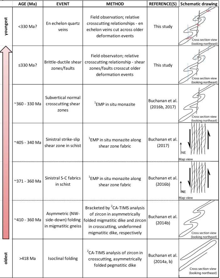
Table 2.1. Structural and geochronological events of rocks in the northwestern and southeastern Nashoba terrane. 1Electron Microprobe Analyses; 2Chemical Abrasion Thermal Ionization Mass Spectrometry.
AGE (Ma) EVENT METHOD REFERENCE(S) Schematic drawing
y o u n g e st
<330 Ma? En echelon quartz veins
Field observation; relative crosscutting relationships - en echelon veins cut across older
deformation events
This study
≤330 Ma? Brittle-ductile shear zones/faults
Field observaton; relative crosscutting relationship - shear
zones/faults crosscut older deformation events This study ~360 - 330 Ma Subvertical normal crosscutting shear zones 1
EMP in situ monazite Buchanan et al. (2016b, 2017)
~405 - 340 Ma Sinistral strike-slip shear zone in schist
1
EMP in situ monazite along shear zone fabric
Buchanan et al. (2017)
~371 - 360 Ma Sinistral S-C fabrics in schist
1EMP in situ monazite along shear zone fabric
Buchanan et al. (2016b) ~410 - 360 Ma Asymmetric (NW-side-down) folding in migmatitic gneiss
Bracketed by 2CA-TIMS analysis of zircon in asymmetrically folded migmatitic dike and zircon
in crosscutting, undeformed migmatitic dike, respectively
Buchanan et al. (2014b) o ld e st >418 Ma Isoclinal folding 2
CA-TIMS analysis of zircon in crosscutting, asymmetrically
folded pegmatitic dike
Buchanan et al. (2014a, b)
NE
Figure 2.5. Schematic cross section of an example of channel flow in the Himalayas.
host rocks (Beaumont et al., 2001; Grujic et al., 2002). These plutons have similar geochemistry and ages to the leucosome in the channel (Grujic et al., 2002; Godin et al., 2006).
2.3 Methods
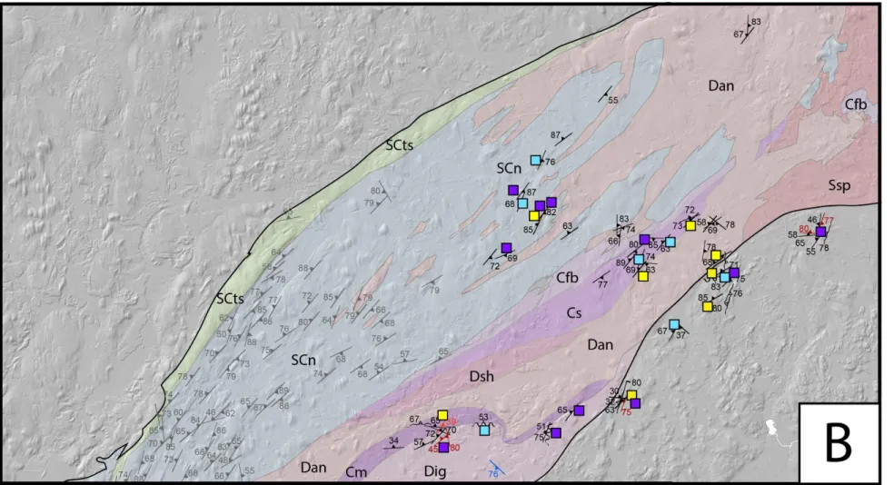
Three summers (2016 – 2018) were spent mapping bedrock, and measuring planar and linear structures (see Appendix A) in the Nashoba-Putnam terrane in Massachusetts and Connecticut. Structural data were collected in the southeastern Nashoba terrane, and the Putnam terrane (Figures 2.3 and 2.4). Planar structures measured include foliation, shear zones, brittle fault zones, and en echelon veins (Figures 2.3 and 2.4). Individual foliation planes were plotted as pole- to-plane in stereographic projections to observe trends in orientations of fabrics (Figure 2.6). Linear structures measured include fold hinge lines and stretching/mineral lineations (sillimanite, amphibole, biotite, muscovite, quartz, feldspar, and chlorite) (Appendix A; Figure 2.6). These data were collected to build upon the field work of Buchanan et al. (2014a, 2014b, 2015, 2016a, 2016b, 2017) in the northwestern Nashoba terrane.
Data from this study and from Buchanan et al. (2014 – 2017) were brought into ArcMap 10.5.1 (a geospatial system capable of various useful analysis methods). Bedrock geologic maps with structural data are presented in Figures 2.3 and 2.4. The terrain base maps were created from Digital Elevation Models (DEMS) that were downloaded from National Science Foundation
Figure 2.6. Equal-area lower-hemisphere projections of poles to foliation, and the trend and plunge of mineral/stretching lineations and fold hinges measured in the (A) northwestern Nashoba terrane, (B) southeastern Nashoba terrane, and (C) in the Putnam terrane.
Earthscope’s OpenTopography open source website (https://portal.opentopography.org/datasets), and subsequently converted to smoothed hillshades in ArcMap 10.5.1. Geology base maps were downloaded from the United States Geological Survey website in “.KML” file-format, then converted into shapefiles in ArcMap 10.5.1. Outcrop locations with field observations were plotted in ArcMap 10.5.1 using the NAD83-converted-to-WGS84 geographic coordinate system. Geologic maps were then converted to, and finalized in, Adobe Illustrator format (Figures 2.3 and 2.4).
Stereographic projections were created using the program Stereonet (Allmendinger et al., 2013). Stereographic projections were created for the northwestern Nashoba terrane and southeastern Nashoba terrane (Figure 2.6A and 2.6B). The low degree of outcrop and observed deformation in the Putnam terrane make it difficult to correlate deformation in the Putnam terrane with deformation in the Nashoba terrane. Thus, data from the Putnam terrane was plotted separately from the Nashoba terrane (Figure 2.6C), but was not subdivided further. Foliations, lineations, and fold hinge lines were plotted separately (Figure 2.6).
2.4 Results
The orientations of the foliation, stretching and mineral lineations, and fold hinge lines, vary between the northwestern and southeastern Nashoba terrane and the Putnam terrane (Figure 2.6). In the northwestern Nashoba terrane, the foliation generally has a moderate to subvertical dip to the northwest, with fewer foliation planes that dip steeply to the southeast (Figure 2.6A). Stretching and mineral lineations including sillimanite, amphibole, biotite, quartz, and feldspar mainly plunge shallowly to moderately, and locally steeply to subvertically toward the northeast and southwest (Figure 2.6A). Fold hinge lines generally plunge moderately to the north-northeast (Figure 2.6A). In the southeastern Nashoba terrane, the foliation generally has a shallow to subvertical dip to the northwest, with lesser foliation with a steep to moderate dip to the southeast (Figure 2.6B). These foliations dip north and south along localized zones (see below; cf. Pipkin et al., 2019). Stretching/mineral lineations in the southeastern Nashoba terrane have a steep plunge to the west, and a few stretching/mineral lineations plunge to the southwest, northwest, and northeast (Figure 2.6B). Fold hinge lines plunge moderately to the southwest and northeast; fold hinge lines that plunge to the southwest are more clustered than those that plunge to the northeast (Figure 2.6B). The foliation in the Putnam terrane generally has a shallow to steep dip varying
between the north, northwest and west (Figure 2.6C). Stretching/mineral lineations in the Putnam terrane are scant, and have no obvious pattern, but very generally have a moderate to shallow plunge toward the northwest and southwest (Figure 2.6C). Fold hinge lines plunge shallowly to the northeast and moderately to the southwest (Figure 2.6C).
Isoclinal folds are the oldest recorded structures and are only occasionally observed in migmatitic metavolcanic gneisses in the southeastern Nashoba terrane (e.g., Figure 2.7A). Asymmetric folds are the structures most observed throughout the Nashoba-Putnam terrane (e.g., Figure 2.7A – F and 2.7H – I), and refolded the isoclinal folds (e.g., Figures 2.7A and 2.7F). The asymmetric fold interlimb angle ranges generally from close to tight throughout the southeastern Nashoba terrane (Figures 2.7A – 7F, 2.7H). The movement direction of asymmetric folds was determined in the field by the plunge of fold hinge lines and/or stretching/mineral lineations on fold limbs (Appendix A). Asymmetric folds and associated S-C and S-C′ shear fabrics show mostly side-down and side-up movement along steeply to moderately northwest-dipping foliation. Fold hinge lines and stretching/mineral lineations associated with this dip-slip movement are generally subhorizontal and down-dip, respectively. Local top-to-the-southeast movement occurred along a shallowly northwest-dipping foliation (Figure 2.7D). Strike-slip (sinistral and dextral) movement is recorded along a steeply northwest-dipping foliation. Fold hinge lines and lineations along strike-slip planes are generally subvertical and subhorizontal, respectively. Oblique movement along a moderately northwest- and southeast-dipping foliation is also indicated by asymmetric folds and shear fabrics (see Figures 2.3, 2.4, and 2.7, and Appendix A for locations of, and measurements associated with, observed movement sense). Fold hinge lines and lineations plunge shallowly to moderately to the northeast or southwest on surfaces with oblique movement. Late shear zones crosscut asymmetric folds and occur mostly in the southwestern Nashoba terrane. Normal movement is preserved along S-C and S-C′ fabrics comprising biotite, muscovite, and quartz. Subvertical northwest- and southeast-dipping mylonitic and brittle-ductile shear zones crosscut asymmetric folds (Figure 2.7G and 2.7H), and show both normal and reverse movement. Late, randomly orientated local quartz-filled en echelon veins (Figure 2.7I) are present along the boundary of the southeastern Nashoba terrane, and crosscut all earlier structures (Table 2.1). Deformation events in the southeastern Nashoba terrane based on these overprinting structures are outlined in Table 2.1 and shown schematically in Figure 2.8.
Figure 2.7. Field photos of structures throughout the Nashoba-Putnam terrane. (A) Isoclinal folds that are folded by northwest-side-down asymmetric folds in the northwestern Nashoba terrane. (B) Northwest-side-down asymmetric folds in the southeastern Nashoba terrane. (C) An example of northwest-side-down asymmetric folds. (D) An example of top-to-the-southeast asymmetric folds along a subhorizontal plane. (E) An example of dextral asymmetric folds along a subvertical foliation plane. (F) Isoclinal folds that are folded by oblique sinistral-normal asymmetric folds along the Honey Hill Fault. (G) Brittle-ductile ~1-centimeter-wide shear zones that crosscut northwest-side-down asymmetric folds. (H) Brittle-ductile ~2-centimeter-wide shear zone that crosscut top-to-the-east movement. (I) Quartz-filled en echelon veins.
Figure 2.8. Schematic block diagram of deformation in the Nashoba-Putnam terrane (see discussion for deformation events). Gradients in the Merrimack belt and Avalon terrane represent metamorphic gradient, where darker colors represent higher grade of metamorphism.
Movement senses in the Putnam terrane were difficult to interpret in the field, in part because of the lack of outcrop, and in part because many outcrops have been glacially eroded and smoothed to flat, two-dimensional exposed surfaces. Furthermore, many outcrops on existing bedrock geologic maps in Connecticut were inaccessible, because they are now located on private land where access was not granted by the owners. Rocks of the Putnam terrane are pervasively overprinted by randomly orientated chlorite and epidote, making original structures difficult to observe. Observable asymmetric folds and S-C shear fabrics in the Putnam terrane indicated reverse or normal movement along shallowly to steeply west- to northwest to north-dipping foliation (Figures 2.4 and 2.6C). Fold hinge lines associated with dip-slip movement plunge shallowly to the northeast and southwest, and stretching/mineral lineations plunge down-dip
(Appendix A). Deformation observed along the Honey Hill Fault at the southern boundary of the Putnam terrane was consistently oblique sinistral-normal along moderately north- to northeast-dipping foliation (labeled in Figure 2.4). Fold hinge lines plunge shallowly to moderately to the northeast and mineral lineations plunge moderately to the northwest. These are both associated with oblique sinistral-normal movement along the Honey Hill Fault.
Two changes in foliation orientations are observed throughout the Nashoba-Putnam terrane (Figures 2.3 and 2.4). First, the dip angle of foliation planes is steep to moderate in the northeastern Nashoba terrane, north of the approximate latitude of Boston, Massachusetts, and moderate to shallow in both the southwestern Nashoba terrane and Putnam terrane (Figures 2.3 and 2.4). Second, the boundary between the Nashoba-Putnam and Avalon terranes is generally defined by a northwest-dipping foliation (e.g., Figures 2.1, 2.2, 2.3, and 2.4), but locally the boundary trends west and is defined by a north-dipping foliation (Figures 2.3 and 2.4). This is reflected in the southeastern Nashoba terrane stereographic projection (Figure stereo 2.6B) where a relatively high number of foliation measurements are north-dipping, because they were collected along one of these major west-trending boundaries (Figure 2.8; Pipkin et al., 2019). These west-trending boundaries are further discussed in Chapter 4. One major west-trending segment lies at the latitude of Boston, Massachusetts. Another one lies at the southern boundary between the Putnam and Avalon terrane, along the north-dipping Honey Hill Fault. The foliation is north-dipping to the south of the fault in the Avalon terrane. The foliation in the Putnam terrane, however, does not follow the orientation of the boundary, and mostly dips northwest (Figure 2.4). The movement sense along these north-dipping foliations throughout the entire Nashoba-Putnam terrane generally varies. Along the Honey Hill Fault, however, asymmetric folds with northeast-plunging fold hinge lines indicate sinistral-normal movement (Figures 2.3 and 2.7F).
2.5 Discussion
2.5.1 Deformation events in the Nashoba-Putnam terrane
In general, four or five main generations of deformation can be recognized in the Nashoba-Putnam terrane (Table 2.1). The oldest structures are isoclinal folds, which are pervasively present throughout the northwestern Nashoba terrane. The scarcity of isoclinal folds throughout the southeastern Nashoba terrane and Putnam terrane may be explained either by outcrop exposure bias (as is likely in the Putnam terrane), or by scale of the isoclinal folds relative to the size of the
outcrop. U-Pb CA-TIMS analysis of zircon from an asymmetrically folded pegmatitic dike that crosscuts isoclinal folds indicate that the isoclinal folds are > ~418 Ma (Buchanan et al., 2014a, b) (Table 2.1).
Asymmetric folds overprint the isoclinal folds (Table 2.1), and indicate northwest-side-down movement in the northwestern Nashoba terrane (Buchanan et al., 2014a,b, 2015a, 2016b, 2017) and northwest-side-down, northwest-side-up, and top-to-the-southeast folding in the southeastern Nashoba terrane and Putnam terrane (Severson et al., 2017; Figures 2.3, 2.4, and 2.7A-F and 2.7H-I). Northwest-side-down movement may represent the overall fold vergence, where northwest-side-up and top-to-the-southeast asymmetric folds then represent the overturned limb of tight and close folds, respectively (labeled in Figure 2.8). Asymmetric folds indicate sinistral, dextral and oblique, normal, and reverse movement in the southeastern Nashoba terrane and in the Putnam terrane (Appendix A). U-Pb CA-TIMS analysis of zircon from an asymmetrically folded migmatitic dike and a crosscutting undeformed dike indicate that northwest-side-down movement initiated at ~410 Ma and ended by ~360 Ma (Buchanan et al., 2016b, 2017). Sinistral movement occurred between ~405 Ma and ~340 Ma based on U-Th-Pb EMP analysis of in situ monazite aligned along S-C fabrics in schist (Buchanan et al., 2016b, 2017). Sinistral S-C fabrics in schist formed late during northwest-side-down folding within migmatitic gneiss (Table 2.1). These structures are interpreted as a result of strain partitioning of the sinistral strain into localized shear zones in schist during penetrative northwest-side-down folding in migmatitic gneiss (Buchanan et al., 2016b, 2017).
Northwest-dipping ~0.5 to 1.0 meter-thick subvertical late normal shear zones crosscut asymmetric folds (Figure 2.7G and 2.7H), and may reflect a third deformation event, or later stage of normal movement at shallower crustal levels than northwest-side-down (normal) asymmetric folds. In situ U-Th-Pb EMP analyses of monazite aligned with shear fabric in one of these crosscutting shear zones indicate that late normal shear zones formed between ~360 and 330 Ma in the Nashoba terrane (Table 2.1; Buchanan et al., 2016b, 2017). Brittle-ductile ~1 to 5 centimeter-wide, subvertical shear zones and faults crosscut asymmetric folds and may crosscut the normal ductile shear zones. They show normal and reverse movement senses, and are expressed by anastomosing veinlets when brittle, and thin parallel bands of mylonite with indecipherable movement senses and directions when ductile (Figure 2.7G and 2.7H). Quartz-filled en echelon
veins with highly variable orientations crosscut all earlier structures throughout the Nashoba-Putnam terrane (Table 2.1; Figure 2.7I).
2.5.2 Structural domains within the Nashoba-Putnam terrane
Stereographic projections from this study and the field work of Buchanan show that foliation, lineation, and fold hinge orientations vary between the northwestern and southeastern Nashoba terrane and the Putnam terrane (Figure 2.6). Furthermore, there are terrane-scale structural observations that are not associated with the five generations of deformation discussed previously. These differences have been broken into three resultant structural domains, which will be discussed below.
2.5.2.1 Northwestern Nashoba terrane structural domain
Buchanan et al. (2016b) determined that subhorizontally to shallowly northeast- and southwest-plunging sillimanite lineations formed during sinistral shear in the northwestern Nashoba terrane. Fold hinge lines in the northwestern Nashoba terrane with northwest-side-down (normal) asymmetry plunge mostly moderately to the northeast with fewer fold hinge lines that plunge shallowly to moderately to the southwest. Some of the moderately northwest-plunging lineations are down-dip along asymmetric folds with northwest-side-down asymmetry and therefore likely formed during the normal movement (Buchanan personal communication; Severson et al., 2017).
2.5.2.2 Southeastern Nashoba terrane structural domain
Based on field observations and measurements in the southeastern Nashoba terrane (Figure 2.3), the foliation is mostly northwest- and southeast-dipping (Figure 2.6B), and asymmetric folds exist along these planes. The steep to subvertical west- and northwest-plunging lineations are generally down-dip on west- and northwest-dipping foliation surfaces, respectively, with S-C shear fabrics and asymmetric folds that show northwest-side-down and northwest-side-up movement (Severson et al., 2017). The moderately northeast- and southwest-plunging lineations and fold hinge lines are associated with oblique movement. The shallowly northeast- and southwest-plunging lineations are paired with shear fabrics or asymmetric folds associated with strike-slip movement (Severson et al., 2017). The north-dipping foliation reflects the localized west-trending orientations of the Nashoba terrane and of the Nashoba and Avalon terrane boundary.