Feasibility of using small dams in water harvesting, Northern Iraq
Nadhir Al-Ansari1, Sven Knutsson2, Salih Zakaria3, Mohammad Ezzeldin41&2
Lulea University of Technology, Sweden 3&4
Mosul University, Iraq
Abstract
Iraq is experiencing water-resource shortages which are expected to become more severe in the future. Water harvesting techniques (WH) will definitely help to overcome or minimize the effect of this problem. Two areas (northwestern and northeastern part of Iraq) were tested for the feasibility of WH using small dams not more than 6m height. The locations of the dams and reservoirs were selected depending on the drainage area, the cross section of the valley (to ensure minimum construction material to be used for building the dams) and to minimize evaporation losses and insure the required storage was obtained; the ratio of surface area to storage volume was kept to a minimum. Watershed modeling system (WMS) and linear programming (LP) optimization techniques were applied to maximize the irrigated area, which could be supplied by each selected reservoir for the period 1990–2009.
In northeastern part of Iraq, the technique was applied in Erbil and Sulaimaniyah. In the former, 22 dams (catchment areas ranged between 3.34 to 111.63 km2) were tested. While in the latter, five separated dams were used with total catchment area of 176.79 km2. Their area ranged between 7.35 to 98.08 km2. In northwestern part of Iraq, the technique was applied in Sinjar Mountain. At northern Sinjar Mountain, ten dams were selected, their catchment area ranged between 43.48 to197.7 km2.
The results obtained from all areas were encouraging.
Key words: Iraq, Water harvesting, WMS. INTRODUCTION
Iraq is located in the eastern part of the MENA region. It is surrounded by Iran in the east, Turkey to the north, Syria and Jordan to the west, Saudi Arabia and Kuwait to the south and the Gulf to the southeast (Figure 1).The total area of Iraq is 438320 km2of which 924 km2 of inland water.
Figure 1: Location map of Iraq.
The population is about 32 million with a growth rate of 3.6% (1980-1990). About 25% of the inhabitants live in rural areas. The population density ranges from 5 to 170 inhabitants/ km2 in western desertic and the central part from the country respectively. This rate had dropped since 1989 due to severe economic hardship (Al-Ansari and Knutsson, 2011; Al-Ansari, 2014).Topographically; Iraq is shaped like a basin containing the great Mesopotamian plain of the Tigris and Euphrates rivers. The climate is mainly of a continental, subtropical semi-arid type with the north and northeastern mountainous regions having a Mediterranean climate. The temperature during summer is usually over 430 C during July and August and drops down to 20C and160C during the day and night respectively in winter time.Evaporation and evapotranspiration values are of the order of 1900mm per year.The average annual rainfall is 154 mm, but it ranges from less than 100mm over 60% of the country in the south up to 1200mm in the northeast. The rainy season is restricted between October to April (Ansari et.al, 1981, World Bank 2006; Al-Ansari, 2014).
Due to the presence of the Rivers Tigris and Euphrates, Iraq was an exception till the 1970s (Al-Ansari and Knutsson, 2011; Al-Ansari et.al, 2012; Al-Ansari 2013& 2014a,b, c). It was considered rich in its water resources compared with other countries where the annual allocation per capita reached 6029 m3 in 1995 and expected to be 2100 m3 in 2015 (Nimah, 2008). In other countries as an example, it is 170, 1112, 2162 and 1752 in Jordan, Egypt, United States and Canada respectively (The Economist, 1993). Recently, it is suffering from water shortage problems (Al-Ansari, 2013; Al-Ansari et.al, 2014a, c; Al-Ansari and Knutsson, 2011). United Nations (2010) reported that the Tigris and Euphrates Rivers will be completely dry by 2040.This problem is expected to be more severe in the future where the supply is predicted to be 43 and 17.61 Billion Cubic Meters (BCM) in 2015 and 2025 respectively while current demand is estimated to be between 66.8 and 77 BCM (Alansari, 2013; Al-Ansari et.al, 2014a).
This work represent a test to the validity of Macro rainwater harvesting (RWH) technique at the northern part of Iraq using daily rainfall data.
METHEDOLOGY
Watershed modeling system (WMS) was used to estimate the harvested runoff at the selected five basins at Sulaimaniyah, Erbil Governorates and Sinjar Mountain based on Digital Elevation Model (DEM) of the study area. The runoff volumes were estimated based on soil conservation service curve number (SCS-CN) method. Therefore curve numbers (CN) values were estimated for each basin and modified for dry and wet conditions based on the information obtained from land use map, soil type and the selected basins. Then curve numbers (CN) values were modified for slope.
For the Soil Conservation Service, 1972 (SCS-CN) method, the tabulated curve number is equal to CNII, for normal (average) conditions, and modified for dry and wet conditions, as explained by Chow et al. (1988) through the following equations:
II II I CN CN CN * 058 . 0 10 * 2 . 4 − = (1) II II III CN CN CN * 13 . 0 10 * 23 + = (2) In which:
CNI = Curve number for dry condition CNIII = Curve number for wet condition.
Williams (1995) developed an equation to adjust the curve number to a different slope (Metaxas et.al, 1999 and Paliatos et.al, 2005): * 3 ) ( ] [ III II SLP II CN CN CN = −
[
1
−
2
*
exp(
−
13
.
86
*
SLp
)]
+
CN
II (3) Where:[CNII]SLP = the curve number for average condition adjusted for the slope. SLP = the average fraction slope of the basin.
The details of the procedure and the calibration of the model are well described by (Al-Ansari et.al, 2013; Zakaria et.al, 2012,2013a&b).
STUDY AREA
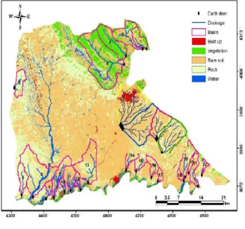
In order to discover for the suitability of using RWH technique in Iraq, three areas were selected at three Governorates (Nineveh, Erbil, and Sulaymaniyah) (Figure 2).
The selected study areas were chosen due to the fact that, they are semi-dry and the topography is suitable to apply the required technique. In addition the required other variables that needed to apply RWH technique were available (Gupta, et. al. 1997). The selection of harvested dams’ locations are to be carefully considered (Stephens, 2010) Therefore, the locations of the dams and reservoirs were selected depending on the drainage area, the cross section of the valley (to ensure minimum construction material to be used for building the dams) and to minimize
evaporation loses and insure the required storage was obtained; the ratio of surface area to storage volume was kept to a minimum.
1. Nineveh Governorates
At Nineveh Governorate northwest of Iraq, Sinjar District was first chosen (Figure 2). Three sites were selected south, north and east of Sinjar Mountain. This area is usually planted with wheat and barley during the winter season. The rainy season extends during November–May with average annual of 300 mm. The soil of Sinjar area has low organic content and consists of sandy loam, silty loam and silty clay loam at south and north Sinjar District and silt clay and silt clay loam for east the District (Rasheed, 1994; Adary et.al, 2002).
At southern Sinjar Mountain, two main basins were selected (A and B). The first with area about 3475 km2, average basin slope is about 2.16 % and basin level is 365.7 (m.a.s.l.), with four sub-basins. The area of the second main basin area is about 5490km2, basin slope is 1.48 % and basin level is 292 (m.a.s.l.), with three sub-basins, for more details see (Al-Ansari et al., (2013a).
At northern Sinjar Mountain, six basins were selected, their area ranged between 43.48 to197.7 km2 and average basins slope between 1.2% to 4.8%, mean basin elevation between 489 to 632 (m), for more details see Zakaria et al., (2012a). Third location was east Sinjar Mountain. In this area four basins were selected, their area ranged between 63.32 to 154.25 km2 and average basins slope between 0.8% to 1.2%, mean basin elevation between 343 to 455 (m), for more details see Zakaria et al., (2012b).
2. Erbil Governorate
Koysinjaq (Koya) district is located within Erbil Governorate in northeast, with about 39484 of population. Geographically, Koysinjaq is a mountainous area. Two studies were carried out for Koysinjaq districts. In the first, four basins located at south east of Koysinjaq districts were selected to discover the area suitability for RWH technique. The area of the four basins ranged between 32.41 to 81.45 km2 and average basins slope between 6.1% to 9.8%, mean basin elevation between 551 to 617 (m a.s.l.). After the success of the first attempt, a second attempt was carried out. In this, 22 basins were selected to evaluate the total runoff that can be harvested. The curve number was calibrated for the slope. This was done due to the effect of the basins slope on the curve number values and consequently on runoff volumes. The area of 22 basins ranged between 3.34 to 111.63 km2 and average basins slope was between 6 % to 28%,and the mean basin elevation were between 361 to 913 (m a.s.l.).For Koya district, the soil texture in the mountainous regions is sandy clay, loam silt or loam clay sand, with an average depth of 130 cm. The soils texture of the plain regions consists of loam clay sand, loam silt and silt clay, with an average depth of 140 cm. (Buringh, 1960; Mohammed, 2013). The annual rainfall depth for the studied records (2002-2011) was varying between 433 to 989 mm. for more details see Zakaria et al., (2013a and b).
3. Sulaymaniyah Governorate
Sulaymaniyah Governorate is Located in northeastern Iraq. The selected study area at Sulaymaniyah consists of five separated basins with total area of 176.79 km2. Their area ranged between 7.35 to 98.08 km2 and average basins slope between 6.8 % to 28.3%, mean basin elevation between 855 to 1211 (m a.s.l.). These basins are located about 7 km North West of Sulaymaniyah city. According to Buringh (1960) the soil of the study area is of three main types (37, 38, and 39). Buringh classified the soil types 37 as great soil group of Chestnut soils and the soil type is silty clay, having a dark brown color, friable surface soil, usually with 1-4% of organic matter and less than 9 % lime. Šimák (2009) indicated that the last two soil types can be identified as C, and D of the Hydrologic Soil Group according to the United States Department of Agriculture Natural Resources Conservation Service (Conservation Engineering Division 1986), for more details see Zakaria et al., (2013c).
MODEL APPLICATION
To apply RWH technique, a digital Elevation Model (DEM) was used with Global Mapper model in order to find suitable locations for the harvested dams. The locations were highly controlled by the local topography of the area. It is to satisfy, first crosscut with the final main runoff trajectories of the catchment area. Second minimum dams cross section that lead to minimum ratio of reservoir’s surface area to its storage volume in order to minimize the dams constructions cost as well as to minimize the losses water by evaporation processes from reservoir’s surface area were used. The second stage was to apply Watershed modeling system (WMS) with the selected areas DEM, its land use, soil type and rainfall data, firstly, to figure out the selected basins and their properties then to estimate the runoff volumes based on Soil Conservation Services-Curve Number (SCS-CN) method. Full details of the procedure and calibration of the model that was used are reported by Al-Ansari et al (2013).For this research, dams of 6 m height were selected, and according to the selected height, the length of the dams, total capacity of the reservoirs as well as their surface area was estimated.
Figure 2. Study araea. 1.Sinjar 2. Koya 3. Sulaimaniyah
In Sinjar area, the common conditionsall selected basins of study areas having slope less than 5 % and located at
the rain-fed farms of Sinjar district, Nineveh Governorate, northwest of Iraq. This area is characterized by semi-arid climate and relatively low annual rainfall of about 300 mm which is the main water resource in the area.
The results showed that there were significant quantities of runoff, which could be stored in the suggested reservoirs sites. The equivalent runoff at southern Sinjar, (Al-Ansari et al., 2013a), could be up to 68.7 mm. Consequently, based on rainfall and resulting runoff values, the runoff coefficients were 0% for dry years and 16.6% for wet years. It should be noted that the basin having the maximum CN value contributed the maximum runoff relative to the other sub-basins. The total volume that can be harvested was 203.8 (106 m3).
At northern Sinjar, (Zakaria et al., 2012a), the volumes of storage runoff produced from maximum rainfall (478.1 mm) that occurred during season (1995-1996) were 17.3, 7.7, 6.1, 2.8, 3.5, and 5.0 (106 m3) for the basin number 1 to basin 6 respectively.
At eastern of Sinjar, (Zakaria et al., 2012b), the minimum and maximum harvested runoff for the entire four basins together reached up to 118.41(106 m3) (season of 1999-2000) and 28187.61(106 m3) (season of 2000-2001) respectively.
The first work done at Koysinjaq (Koya) area, (Zakaria et al., 2013a), was exploratory research to discover the
capability of the area for rainwater harvesting. Thus four basins with total area of 228.96 km2 were selected as a catchment area of average slope ranged between 6.1-9.8 % to estimate the volumes of harvested runoff. The results showed that, the application of Macro RWH can provide a new source of water. The annual volume of water that can be harvested from all selected basins ranged 14.83 to 80.77 (*106 m3) for the study period (2002-2011). This indicates that the technique of Macro RWH can be considered to provide a new source of water to the area and then to minimize the water shortages problem.
The result of the starting work conducted at Koysinjaq area related to Macro RWH technique enhanced further applications of the technique within the area. For this reason, twenty-two basins, (Zakaria et al., 2013b), were identified as the catchment area for the application of RWH technique. Two consecutive adjustments for the curve number were considered. The first was for the antecedent moisture condition (AMC) and the second was for the slope. These adjustments increased the total resultant harvested runoff up to 79.402 × 10⁶ m3. The average percentage of increase of harvested runoff volume reached 9.28%. This implies that water allocation is of the order of 2000 cubic meter per capita per year. This quantity of water will definitely help to develop the area.
Figure 5.1: Map for Koya districts with the selected basins for rainwater harvesting.
Sulaymaniyah Governorate of Kurdistan Region of Iraq was the second of mountain area that tested for the use of RWH (Zakaria et al., 2013c). The study area consists of five separated basins with total area of 176.79 km2, located about 7 km North West of Sulaymaniyah city. Rainfall records for the period 2002-2012 were studied and an average season 2010-2011 was selected to test the efficiency of RWH technique. The results showed that the harvested runoff volume ranged from 0.01 × 10⁶ to 3.53 × 10⁶ m3 in that year (Figure 3).
The total annual
harvested runoff reached about 10.76 × 10
6m
3.
Figure 5.3: Total annual runoff of the season 2010-2011 for all five basins at Sulaymaniyah governorate of Kurdistan Region of Iraq.
The most influential factors for the RWH technique were the size of the catchment area, the distribution and amount of rainfall, the produced runoff water volume, in additional the reservoirs size and the evaporation loss from its surface area.
CONCLUSIONS
Iraq is suffering from water shortages problem. Application Macro RWH will help to
minimize the water crises.
RWH technique had been tested for the study areas at three
Governorates (Erbil, Sulaymaniyah, and Nineveh) located north of Iraq to see the
capability of the area to harvest rainwater. WMS was applied using daily rainfall data for
the considered periods. In these applications, the selection of harvested dams’ locations
was carefully considered. Therefore, the locations of the dams and reservoirs were
selected depending on the drainage area, the cross section of the valley (to ensure
minimum construction material to be used for building the dams) and to minimize
evaporation loses and insure the required storage was obtained; the ratio of surface area to
storage volume was kept to a minimum.
REFERENCES