Review of data types for the
SKB site investigation programme
2002:22 RICHARD KLOSSSI rapport : 2002:22 november 2002 ISSN 0282-4434 AUTHOR/ FÖRFATTARE: Richard Klos.
DIVISION/ AVDELNING: Department of Waste Management and Environmental Pro-tection/Avdelningen för avfall och miljö.
TITLE/ TITEL: Review of data types for the SKB site investigation programme/ Behov av data från en platsundersökning: Översikt och synpunkter på SKB:s platsunder-sökningsprogram.
SUMMARY: SKB is currently undertaking a detailed site investigation programme (SIP) to characterise the geology and surface ecosystems in areas around potential si-tes for a planned repository for spent nuclear fuel.
This report reviews site specific and generic data types needed to characterise biosphere processes relevant to the evaluation of long-term radiological safety in the context of assessments of future impacts arising from the deep geologic disposal of spent nuclear fuel. Focus is on the types of data that make up the different elements of radiological assessment models and how the data used relate to site-specific char-acteristics. The relevance of the SIP to the development of assessment models for long-term assessment is addressed, including the representation of the geosphere-biosphere interface.
Reference to SKB’s programme is made in order to determine how well the current programme will meet the needs of assessment models that will be developed and used in the assessment of long-term safety. The review also provides SSI with a basis for the planning of further SSI R&D work.
The process, by which site-specific information is converted into a form suitable for use in numerical assessment models, can be quite complex. An overview of assess-ment model concepts is provided and the links between these and real-word site in-formation considered. Focusing on the needs of assessment models, the review prov-ides a summary of the main types of analyses and site-specific models that are needed for safety evaluations.
Review of the SIP indicates that information from the programme feeds into a set of detailed site description models. However there is a gap between the descriptive components and the detailed model descriptions needed to configure numerical ass-essment models. Details of system evolution are not clearly dealt with in the pro-gramme. The SIP focuses on a detailed description of the site the present day. Howe-ver, radiological impacts are not expected to reach their peak until far into the futu-re. It is not yet apparent how SKB will use SIP information in the representation of the biosphere system at future times.
It is concluded that the SIP addresses the right kind of entities to allow radiological assessment models to be defined. However it is suggested that a change of emphasis be introduced, so as to focus more on the driving forces for contaminant bearing ma-terial fluxes rather than on turnover times. This means that more attention should be paid to the physical transport processes, integrating existing details of the diffe-rent ecosystems relevant to Swedish conditions. Developments of assessment model-ling capability should consider the need to include a more spatially extended assess-ment model representation than has been the case so far in radiological assessassess-ments. SAMMANFATTNING: SKB genomför för närvarande platsundersökningar som syftar till att karakterisera geologi och ytnära ekosystem på möjliga platser för det planera-de slutförvaret för använt kärnbränsle.
Denna rapport går igenom de platsspecifika och generiska data som behövs för att beskriva de processer i biosfären som är relevanta för analyser av slutförvarets fram-tida radiologiska skyddsförmåga. Rapporten fokuserar på de data som ingår i de ra-diologiska konsekvensmodellerna och hur dessa data relaterar till platsspecifika egenskaper. Vidare diskuteras vilka krav som bör ställas på platsundersökningarna, inklusive karakteriseringen av övergången mellan geosfär och biosfär, med hänsyn
Författarna svarar själva för innehållet i rapporten. The conclusions and viewpoints presented in the report are those of the author an do not necessarily coincide with those of the SSI. syftar också till att ge SSI ett underlag för dess fortsatta planering av forskning
kring platsundersökningar.
Processen att överföra information och data från en plats till ett lämpligt format för numeriska beräkningsmodeller kan vara komplex. Rapporten ger en översikt av de viktigaste analyserna och platsspecifika modellerna som behövs för utvärde-ringen av förvarets långsiktiga skyddsförmåga, och beskriver hur dessa relaterar till verkliga platsdata.
SKB:s platsundersökningsprogram bedöms vara ändamålsenligt för framtagandet av olika typer av platsbeskrivande modeller, men det finns ett gap mellan de kva-litativa beskrivningarna och den detaljinformation som behövs för att konfigurera de numeriska beräkningsmodellerna. Vidare finns det oklarheter i hur SKB hante-rar frågor kring den framtida utvecklingen av biosfären. SKB:s platsundersök-ningsprogram syftar i första hand till att ta fram en detaljerad beskrivning av da-gens förhållanden vid platsen. De största radiologiska konsekvenserna förväntas dock inte uppträda förrän långt in i framtiden. Det är ännu inte klart hur SKB av-ser att använda informationen från platsundersökningarna för att beskriva fram-tida biosfärer.
Den övergripande slutsatsen från denna granskning är att SKB:s platsundersök-ningar kan förväntas ge rätt typ av information för framtagandet av modeller för den radiologiska konsekvensanalysen. SKB rekommenderas dock att lägga större tonvikt på att bestämma drivkrafter för transport av kontaminerat material i för-hållande till omsättningstider. Detta innebär att större uppmärksamhet bör läggas på fysiska transportprocesser och deras beskrivning i olika ekosystem som är rele-vanta för svenska förhållanden. I det fortsatta utvecklingsarbetet med konse-kvensmodeller bör SKB även överväga att ta fram rumsligt mer heltäckande mo-dellbeskrivningar jämfört med tidigare analyser.
Förord
Statens strålskyddsinstitut (SSI) har till uppgift att bedöma om ett slutförvar för använt kärn-bränsle kan uppfylla de krav på skydd av människors hälsa och miljön som ställs i strålskydds-lagen (1988:220) och i SSI:s föreskrifter (t.ex. SSI FS1998:1). Svensk Kärnbränslehantering AB (SKB) påbörjade under 2002 platsundersökningar för lokalisering av ett slutförvar i tre områden i Östhammars och Oskarshamns kommuner. Resultaten från dessa platsundersökningar kommer att utgöra ett viktigt underlag i SKB:s ansökan om att få påbörja bygge av ett slutförvar på en plats. Enligt SKB:s nuvarande tidsplaner kommer en sådan ansökan att inges under senare delen av 2007.
SSI driver ett målinriktat forskningsprogram med syfte att vidareutveckla den kompetens och de granskningsverktyg som behövs för att kunna göra kvalificerade granskningar och bedömningar av SKB:s arbete med slutförvaring av kärnavfall. Det forskningsprojekt som redovisas i denna rapport utgör en sammanställning av data och modeller som behöver tas fram under en platsun-dersökning för att kunna genomföra analyser av slutförvarets långsiktiga skyddsförmåga. Vidare kommenteras översiktligt omfattning och inriktning på SKB:s redovisade program för karakteri-sering av biosfären, inklusive kvartära avlagringar och de övre delarna av geosfären. Resultaten från detta projekt kommer att användas som ett av flera underlag för planeringen av SSI:s fort-satta forskning inom området platsundersökningar.
Arbetet har utförts av Ryk Klos vid konsultföretaget Galson Sciences Ltd i England, på uppdrag av Björn Dverstorp, avdelningen för avfall och miljö. Författaren svarar själv för innehållet i denna rapport.
Contents
1 Introduction and objectives ...3
2 Summary of data types ...5
2.1 Background ...5
2.2 Requirements of assessment models...5
2.3 Information sources for the assessment model parameter database...9
2.3.1 Source term and location... 10
2.3.2 Decay/ingrowth... 10
2.3.3 Spatial organisation and content ... 10
2.3.4 Transfer coefficients ... 11
2.3.5 Biotic accumulation... 12
2.3.6 Dose, exposure and risk ... 12
2.4 Summary of data types... 14
3 Correspondence of SKB SIP and PA models ...15
3.1 Introduction... 15
3.2 SIP elements and their relation to model data requirements... 15
3.2.1 Surface Ecosystems... 15
3.2.2 Geology... 17
3.2.3 Hydrogeology ... 17
3.2.4 Hydrogeochemistry ... 17
3.3 Spatial organisation and content ... 18
3.3.1 Area to be characterised... 18
3.3.2 Use of analogues in characterising geosphere-biosphere interface... 19
3.3.3 Definition of biosphere compartments... 19
3.3.4 Level of detail of biosphere assessment models... 19
3.4 Abiotic transport and accumulation... 20
3.5 Biotic transport and accumulation ... 21
3.6 Intake and exposure... 22
3.7 CCGs – Candidate critical groups ... 22
3.8 The model system at future times... 23
3.8.1 Transparency in development of assessment models... 23
3.8.2 Temporal organisation of biosphere assessment models ... 24
3.9 Summary comments on the suitability of the SIP... 25
4 Summary and conclusions...26
4.1 Summary of data types for assessment models ... 26
4.2 Preliminary review of SKB’s biosphere SIP... 26
4.3 Priorities for biosphere assessment modelling ... 27
5 References...29
APPENDIX A The role of solid material transport in
1 Introduction and objectives
Over the past few years there have been significant developments in the content of biosphere models used in SKB’s performance assessments (PAs) of Swedish radioactive waste disposal options. SKB’s current model configurations require a large amount of data to support and match their potential capabilities.
The aims of this project are:
• to provide the Swedish regulators (SSI) with a compilation of relevant site-specific and ge-neric biosphere data types, including data for the geosphere-biosphere interface, that will be needed to develop an understanding of biosphere processes relevant for evaluation of long-term safety and radiological protection;
• to summarise the main types of analyses and site-specific models that are needed for the safety evaluation;
• to assess how well SKB’s programme meets the above needs, to identify any major gaps in SKB’s programme in relation to SSI’s regulations or international experience, to assess whether the timing of various measurements is appropriate; and
• to provide a base document for SSI’s future work on biosphere characterisation, i.e. for re-view of SKB’s site investigation programme and for the planning of further SSI R&D work. The aims are addressed in the three work areas described below.
Summary of data types
Based on experience in the Swiss assessment programme [e.g., Kłos et al., 1996], the work of BIOMOVS II [1996] and BIOMASS [IAEA, 2001a], as well as elements from the BNFL [2000] and UK Nirex [1997] approaches to biosphere modelling, a review of the components of biosphere assessment models for long-term radiological assessment has been carried out. Refer-ence to biosphere modelling in Project SAFE is also made [Kłos and Wilmot, 2002].
Focus is on the types of data that make up the different elements of radiological assessment models and how the data used relate to site-specific characteristics. The characterisation and representation of the geosphere-biosphere interface is included. The review takes into account the current plans of SKB for the characterisation of the biosphere in Sweden within the spent fuel disposal programme [specifically SKB, 2000; SKB, 2001a; SKB, 2001b]. The current ap-proach to biosphere assessment modelling in Sweden has also been reviewed, in particular the representation of the Forsmark site [SKB, 2001c]. The context for the review is set by the guid-ance of SSI [2000].
Review of necessary site-specific analysis and models
Like data, models used in PA may themselves show varying degrees of site specificity. There is often a hierarchy of models used in the definition of the numerical assessment model ultimately used in the PA calculations since site characterisation data are not usually directly usable in PA models. A phase of interpretation and pre-processing is required. The review considers those site characteristics that can be observed and measured as part of a site investigation programme
and the methods and models by which these are translated into usable entities within the nu-merical assessment model.
Preliminary review of SKB’s biosphere site characterisation programme for spent fuel disposal
The review addresses the following points: • Are the right entities to be characterised?
• What is the corresponding numerical assessment model entity and how are the supporting model data and the assessment quantity related?
• Is the interpretation of measured/observed data correct (taking into account how information may be traced through the system and model identification, justification and description stages)?
• What is the scope of the numerical assessment model data (spatio-temporal, nuclide, chemi-cal boundary conditions – range of applicability within the numerichemi-cal assessment model)? The review also includes discussion of how biosphere characterisation and assessment have been handled in a few other selected radioactive waste disposal programmes (NAGRA in Swit-zerland, and Nirex and BNFL in the UK), to provide a view on the relative state of advancement of SKB’s biosphere programme
2 Summary of data types
2.1 Background
A primary aim of this project is to provide SSI with a review of the relevant types of data for use in the assessment of radiological impact and to discuss the needs of the assessment in terms of the site investigation programme (SIP) being carried out by SKB in support of a license ap-plication for the construction of a deep repository for spent fuel from the Swedish Nuclear Po-wer Programme.
Performance assessments of this kind have been carried out over several years by SKB and the-re is a wealth of background material and experience in the definition and application of long-term assessment models. Nevertheless, although the broad outlines of the models to be used are well established, the details of the actual models themselves (in terms of the geographic areas, and evolutionary trends) are not yet finally established. It is also likely that when the sites investigated are fully characterised, model details may include some feature, events and proc-esses (FEPs) not yet incorporated in the modelling work carried out to date.
It is still unclear which models and codes SKB will use as a basis for the license application. However, various sub-models are already in existence and, together with the experience of other similar programmes, it is possible to determine the kinds of systems and sub-systems which are likely to be employed in PA modelling. In order to characterise the types of data required for assessment of long-term radiological impact, experience from elsewhere will be used [Kłos et
al., 1996; BIOMOVS II, 1996; Nirex, 1997; BNFL, 2000; IAEA, 2001a] as well as direct
refer-ence to recent SKB biosphere modelling effort [Karlsson et al., 2001; SKB, 2001c] and reviews thereof [Kłos and Wilmot, 2002].
2.2 Requirements of assessment models
Ultimately, long-term radiological safety must be judged, at least in part, by the application of numerical assessment models and the interpretation of their results. The purpose of the model is to evaluate the potential health impact of the release of radionuclides from the repository to the biosphere1. Numerical assessment models, and the data used with them, are the primary focus of
this review of data types. At this stage it is useful to review the composition of such models. Numerical assessment models must include representations of:
• inputs of radionuclides to the system; • transport of contaminants within the system;
• accumulation of contaminants in components of the system;
• exposure (risk/dose) of selected groups to environmental concentrations of contaminants in the system; and
• losses of contaminants from the modelled system.
It is important to recognise that, in the biosphere component of the overall PA model system, concentrations of radionuclides are likely to be low enough that the model should represent the system as it would be in the absence of contaminants. All FEPs modelled should be those at work whether or not radionuclides have been released into the system. In this way the focus shifts to the FEPs acting to move material around the system. Movement of material drives the transport of contaminants.
In general, material flows may be characterised as water and solid material fluxes [Kłos et al., 1996; BIOMOVS II, 1996]. Recent work by SKB [Kumblad, 1999] has focused on the representation of ecosystems. Although attention has been on transport of 14C, movements of
biota containing contaminants in trace quantities may be possible. Ecosystem modelling of biotic movements may therefore play a role in a more generalised description of radionuclide transport [cf. detritus flows in BIOMASS ERB2B: IAEA, 2001]. Gaseous-phase transport is also a possibility but release of radionuclides in groundwater across the geosphere-biosphere interface means that the main focus will be on water solids and organic carbon movements. Nonetheless, the need to develop gaseous-phase transport and accumulation models cannot be ruled out at this stage.
On the basis of current practice, it seems likely that the numerical models will be based on first-order linear dynamics using a compartment-model approach. The rate of transfer of radionuclide
N between compartments i and j is defined by the fractional transfer rate from compartment i to
compartment j: i ij ij
N
N
i
N
j
i
N
=
=
t
compartmen
in
of
amount
total
unit time
in
to
from
moved
of
amount
λ
. (1)
Transfers are mediated by:
ij
F [m3 a-1] water fluxes;
ij
M [kg a-1] solid material fluxes; ij
C [kg a-1] organic carbon fluxes; and
ij
G [m3 a-1] gaseous fluxes.
The distribution between these phases and the amount retained (accumulated) in compartment i is determined by the internal properties of the compartment (the k parameters defining them:
). In general terms, the fractional transfer rates are a function of all of these factors:
(
k)
i ij ij ij ij ij=
f
F
,
M
,
C
,
G
,
P
λ
y-1. (2)Written in this way, the task of defining assessment models is to identify the driving forces re-sponsible for material transfer between compartments and then to determine how much of the internal content moves with each of the flows.
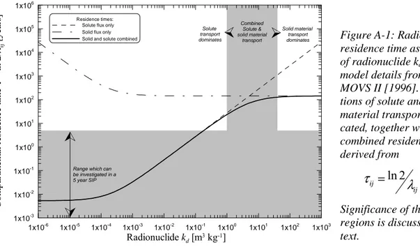
The current generation of numerical assessment models used by SKB employs compartment models but, at least at the time of the modelling carried out in support of Project SAFE [Lind-gren et al., 2001; Karlsson et al., 2001], did not link inter-compartmental transfer rates to material fluxes. Instead, the various sub-models employed direct measurements of compartmen-tal contaminant residence times (~1/ ).
While the residence-time approach has advantages in that short-term measurements with radio-active tracers can be performed in the environment to determine a range of transfer values, the
k i
P
ij
λ
methodology suggested by equation (2) is more robust. Appendix A illustrates the potential problems with the use of residence time data. Short-term measurements will overlook long-term processes – such as those associated with solid material transport.
Basing transport on material fluxes offers the possibility of utilising a specific mass balance scheme for determining contaminant transfer. Such a foundation means that more confidence in the model is generated since the physical representation is more robust. Alternatives (residence times or transfer factors) could be used, but these are specific to radionuclides and they do not say anything about the driving forces. Neither is the translation of transfer factors from one ra-dionuclide to other rara-dionuclides straightforward: there must be some mechanistic understand-ing of the processes involved.
Understanding of the system forces is important when carrying out uncertainty (particularly probabilistic) calculations. In setting a range of residence times or transfer coefficients, it can often be the case that what appear to be reasonable variations in transfer factors or residence times imply unrealistic values or combinations of driving forces. Uncertainty calculations based on probability distribution functions of residence time and/or transfer coefficients should be approached with extreme caution.
Finally, defining transfers in terms of the contributing material fluxes helps provide a direct link to elements of the site description.
As far as transport and accumulation is concerned, the question is the extent to which elements of the SIP meet the requirements of the characterisation of fluxes in the modelled system in terms of the F , ij M , ij C , ij G and ij
k i
P .
Compartment modelling implies that there are a number of compartments in a network. The general form of transport, accumulation and exposure are written below. These help define the types of data required by assessment models. The generic nature of the expressions written here emphasises interconnectivity of the network. Simplifications are possible but these can be de-termined as a consequence of a review of details from the SIP. SKB [2001a] recognises the iterative nature of this process.
The inventory (in Bq) of radionuclide N in the ith compartment at time t is given by:
( )
∑
∑
≠ ≠ − + + − = j i i N ij i j j N ji i N i N N i i N N M N t S dt dNλ
λ
λ
λ
[Bq a-1] (3)where the source of N into the ith compartment is SN
( )
ti , the decay rate of N is
λ
N [a-1] and the
amount of the precursor radionuclide, M, in i is
M
i. The intercompartmental transfer rates into and out of i are defined for each radionuclide. An important purpose of the assessment model is to convert this distribution of radionuclides into estimates of radiological risk.The concentration of N, as a function of time, is given by:
( )
( )
( )
t V t N t C i i N i = [Bq m -3] (4)which accounts for the time variation in compartment volume. i
i
Traditionally, models for long-term radiological assessments have treated geological compo-nents as dynamic entities within the model structure. Biotic compocompo-nents have been treated as being in equilibrium with the dynamic parts of the model. The concentration in the kth biotic component of the model is then given by:
( )
∑
( )
∑
( )
= = = =+
=
bio cmp pth cmp N l N i N i l i l N p N i N i N i p k N i kt
K
C
t
I
B
t
B
, 1 , 1 , , , 1 , 1 , , ,[Bq kg
-1] (5)
where there are Npth pathways by which the contents of compartment i can reach the kth biotic component and there are Ncmp compartments in the network. The
K
kN,p are the concentration oraccumulation factors via which contaminants in i can accumulate in k. Ik,i are intake rates of the kth biotic component from compartment i.
Dose and risk depend on the degree of interaction between the selected groups with environ-mental concentrations of radionuclides given by Equations (4) and (5). For foodstuff consump-tion, the interaction is the annual consumption of material from a given location within the compartmental network. For airborne contaminants, the interaction is the breathing rate at a given location. For external irradiation, the exposure rate is determined by the amount of time spent at a given location. BIOMASS [2001] provides a detailed discussion of these matters and of the ways in which candidate critical groups can be identified to match the societal context of a spatially extended network of biosphere compartments.
The total dose from radionuclide N is:
( )
∑
( )
∑
( )
= = = = =+
=
exp cmp exp bio cmp N m N i N i m i N m N m N k N i N i k m k N m Nt
C
E
H
t
B
E
H
t
D
, 1 , 1 , , 1, 1, 1 , ,[Sv a
-1], (6)
where there are Nexp exposure modes2 and
N
bio biotic components in the system. The exposure rates Ek,m and Ei,m depend on the source material (biotic or abiotic) and the dose per unitex-posure converts from exex-posure to dose ( N m
H ).
The total risk arising from the exposure (excluding probability of the exposure arising) is then given by:
( )
∑
( )
==
nuc N N Nt
D
t
R
, 1γ
(7)
The summation is over all radionuclides (
N
nuc) and uses the conversion factor identified by SSI [2001].
2 Ingestion, inhalation and external exposure, as identified by BIOMASS [IAEA, 2001]. pth cmp k,p k,i bio exp i,m k,m m nuc
2.3 Information sources for the assessment model parameter
database
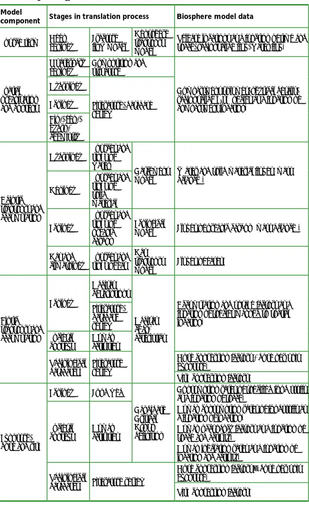
Table 1 provides a summary of the main data types required by biosphere numerical assessment models. An indication of the source material and spatial scale to be used in determining parame-ter values is also provided.
Table 1. Summary of radiological assessment model data types. Source material indicates the
typical sources used to provide data for assessment models. An indication of the scale of appli-cability of source data is given. Significant local-scale input is indicated in bold type.
Model
component Data type Source material Spatial scale
Source term
and location
( )
t SN
i Geosphere modelling Local/regional scale Decay/
ingrowth λN
Radiochemical databases Global scale
Fij Hydrology; hydrological maps
[Kłos et al., 1996]; catchment modelling [Nirex, 1997]
Local/regional scale
Mij Geology; lake sediment studies
[SIA, 1989]; bioturbation [Muller-Lemans and Van Dorp, 1997; IAEA, 2001a]
Local/regional scale
Cij Ecology [e.g., Kumblad, 1999] Local/regional scale
Gij Gas and climatology; no
systematic inclusion in assessment models to date
Local/ regional scale
Abiotic transport and accumulation Transfer coefficients – N ij λ k i P Internal characteristics of biosphere components;
hydrochemistry, geochemistry and biochemistry, geology, ecology; literature review Local scale; analogues, regional scale Concentration and uptake factors N i p k
K, , Radioecological databases, literature
review
Regional scale Biotic
accumulation
Intake rates Il,i Animal husbandry literature,
societal context.
Regional scale Exposure
rates Ek,m
Ecology, societal context, literature review; habit surveys
Regional/national scale Dose per unit
exposure N m H International database [e.g., ICRP, 1996] Global scale Dose, exposure and risk Risk conversion factor
γ SSI [2001] Global scale
i ij ij ij ij ij i k,p,i l,i k,m m N
Table 1 indicates that a good proportion of the numerical model database is dependent on an understanding of conditions on the local or regional scales. The process of converting the knowledge base into a parameter database can be quite involved. It is rarely possible to translate directly from site characterisation data to parameter values for use in numerical assessment models. Specific comments on the data types summarised in Table 1 follow.
2.3.1 SOURCE TERM AND LOCATION
Geosphere modelling provides the source term to the biosphere. However, it is important to recognise that the location of the geosphere-biosphere interface might change in time and space.
2.3.2 DECAY/INGROWTH
Decay constants for radionuclides are readily available from a number of sources and have glo-bal relevance.
2.3.3 SPATIAL ORGANISATION AND CONTENT
The most obviously local components of the model are the structural elements – the physical compartments themselves. Their extent is determined by a number of factors:
• mixing (compartmental model assumptions); • ecosystems; and
• boundary conditions/conservatism.
The physical basis for deciding spatial extent is that within the compartment the contaminants should be well mixed on timescales that are fast compared to the timescales of processes caus-ing transport. Commonality of internal properties is a suitable basis for decidcaus-ing compartment size, but it may be necessary to sub-divide spatially extended compartments.
The ecosystems approach provides a useful and systematic method of identifying common ar-eas. However, it is likely that, within ecosystems, there will need to be further sub-divisions as the modelling needs to account for structure from the surface layers down to the base of the quaternary deposits on the crystalline bedrock in areas where the discharge from the geosphere takes place.
A further constraint on compartment size and structure may be that the assessment requires that boundary conditions be set such that the loss of contaminants across boundaries is restricted, with the effect that radiological impacts are conservatively restricted to specified regions of the system model and thereby maximised in a controlled way.
The composition of compartments is also highly site specific but there can be a strong regional component. For example, soil type, composition and structure are likely to vary little on the regional scale. There may be wide variation in properties on short spatial scales but the dose model, taking foodstuff production from comparatively broader spatial scales, will effectively average out such variations. Detailed site investigations may not be a prime requirement in de-termining composition provided that a sufficient regional database is available and so long as any unique features at the local scale have been accounted for.
Not all composition information is used directly in assessment models. Knowledge of composi-tion and chemical condicomposi-tions in representative structures can be used to interpret appropriate elemental kd-values. This approach is taken by Tits and Van Dorp [1997], where grain size of
2.3.4 TRANSFER COEFFICIENTS
Hydrology
It is with the determination of the transfer coefficients that the major local influence is seen: in Project SAFE the use of residence times illustrates one approach [Lindgren et al., 2001]. In other programmes, there is a greater focus on water fluxes as the driving force:
• In the UK, Nirex [1997] derives water flux data from a detailed model of the catchment sys-tem which provides background data for the radiological assessment model. With this link, the radiological model is made consistent with the hydrological processes at work in the type of system under consideration. There is also the potential for the catchment model [SHETRAN-UK: Thorne, 1998] to provide input parameters to the assessment model di-rectly.
• The approach in Switzerland [NAGRA, 1994] is different again in the way in which local information is used. Groundwater maps [see Thury et al., 1994] are used to define groundwater flows. These are adopted directly as inputs to the terrestrial compartments of the TAME model [Kłos et al., 1996]. Other water flows (precipitation, evapotranspiration, irrigation, river flows) derived from local parameters and a mass balance scheme are used to determine the fate of water in the model at run time.
Both the UK and Swiss approaches employ an explicit representation of the catchment system to determine transport resulting from water movements. Regional scale data (meteorology, hy-drology) are used together with local information on the structural components of the system (area, thickness, composition, etc.) to represent local conditions.
Geology
NAGRA’s approach explicitly deals with solid material transport in a mass balance framework. Again, local or regional data are used as input to the assessment model [e.g., an inferred re-gional erosion rate – SIA, 1989]. In the Nirex [1997] approach, solid material transport is im-plicitly included in the catchment modelling, which informs the choice of parameters in the radiological assessment model.
Ecology
Müller-Lemans and Van Dorp [1996] illustrate the way in which information on biota-facilitated radionuclide transport can be turned into parameters for assessment models. A de-tailed review is carried out to provide a small number of parameters for the assessment model (biomass activity and mass transport rate per unit area of soil).
Kumblad [1999] provides a detailed analysis of the movement of organic carbon in a particular ecosystem (a lake). In Project SAFE this is used to support the modelling of 14C transport.
How-ever, thought might be given to the inclusion of this level of detail in the transport of other key radionuclides (in parallel to water-mediated and solid material-mediated fluxes). Biotic move-ment would be expected to transport incorporated radionuclides in a similar way to that in which water carries dissolved species and solid material carries sorbed elements. As the focus is on transport, the need would be to estimate the amount of material transported from one com-partment and deposited in another (e.g., by senescence). The work of Kumblad indicates that detailed local-scale ecological models can be constructed which could be used in assessment calculations in a way analogous to the mass balance approach in the TAME model for water and solid material transport.
Gas and climatology
Gas-facilitated transport has not received a great deal of attention. Nirex [1997] considers the gas pathway for the transport of 3H, 14C, and 220/222Rn. The focus is on radionuclides transported
in bulk gas – as gaseous material, suspended in droplets, and vapour of solid material. NA-GRA’s model calculates airborne dust loads but does not include a rigorous mass balance scheme for gas in the same way as for water and solid material transport calculations. Gas transported through soils and other quaternary deposits may be accounted for in the transport of water [see, for example, Stevens, 1996].
2.3.5 BIOTIC ACCUMULATION
Radioecological databases relevant on the local scale are the primary source of information determining accumulation, concentration and uptake factors. Local conditions in the modelled area determine which of the database values are appropriate in the modelling. While it would be possible to carry out a site investigation programme to determine the uptake and accumulation factors, it is not reasonable to expect that site characterisation will be carried out at this level of detail.
Regional farming practices and other ecosystem understanding provide information for intake rates of biota. BNFL [2000] used a detailed model of bovine nutrition in determining the areas of land required for cattle farming around the Drigg site based on regional knowledge of grass yield and dietary requirements of cattle.
2.3.6 DOSE, EXPOSURE AND RISK
Dose per unit exposure factors for intake and inhalation are catalogued by ICRP [e.g., ICRP, 1996] and are globally appropriate, as is the risk conversion factor. External γ-irradiation con-version factors may need to be considered on a regional basis to take into account characteristics of Swedish soils and sediments.
Table 2. Summary of methods for deriving parameter databases for long-term radiological
assessment models.
Model
component Stages in translation process Biosphere model data
Source term Deep geology Fracture flow model Geosphere transport model
Release locations as a function of time and space, radionuclide flux, water flux. Quaternary
geology Composition and structure Hydrology Ecology Spatial organisation and content Bio-, geo-, hydro- chemistry Literature, database review
Compartment volumes, physical details, radionuclide kds. Species as a function of compartment location. Hydrology Sources and sinks of water Geology Sources and sinks of solid material Catchment model
Water and solid material fluxes (mass balance). Ecology Sources and sinks of organic carbon Ecological
model Fluxes of organic carbon (mass balance). Abiotic transport and accumulation Gas and climatology Sources and sinks of gas Gas transport
model Fluxes of gases. Habitat descriptions Ecology Literature, database review Societal
context Human activities
Accumulation and uptake factors as a function of species mapped to spatial location.
Dose conversion factors - dose per unit exposure. Biotic transport and accumulation Radiological databases Literature review Habitat char-acteristics
Risk conversion factors.
Ecology Food web
Societal
context Human activities
Candidate Critical Group definition
Consumption rates of specified food stuffs as a function of space.
Human consumption rates of foodstuffs as a function of location.
Human occupancy factors as a function of space and activity.
Human inhalation rates as a function of location and activity.
Dose conversion factors – dose per unit exposure.
Exposure, dose and risk
Radiological
2.4
Summary of data types
Full databases for assessment models must concentrate on the areas listed below. Table 2 sum-marises the means by which information about the site is converted into numerical parameters in the radiological assessment modelling database.
• Spatial organisation and content
Basic identification of the types of compartments (terrestrial, aquatic, ecosystem), location and nature of geosphere-biosphere interface. Disaggregation into sub-compartmental structu-res (soil layers, water, sediment, etc.). Physical dimensions. Definition of the content – mate-rial structure and composition, biotic content (including societal context). Mapping to topo-graphic map.
• Transport and accumulation (abiotic and biotic)
The driving forces for material movement – water, solid, organic carbon and gaseous fluxes across compartment boundaries – factors controlling the partitioning of contaminants be-tween these four phases.
• Biotic concentration and uptake
Concentration factors for flora, uptake factors and consumption rates for fauna for represen-tative species in different habitats. Identification of biota types and location – ecosystem map (linked to topographic map). Review of literature and databases, correlating structure and content to numerical ranges.
• Exposure rates and candidate critical groups
Intake rates of foodstuff from specific locations, time spent at location, inhalation rates de-pendent on activity and location.
• Exposure to dose and risk conversion
Radionuclide-specific conversion factors for dose per unit intake on inhalation and ingestion, external irradiation conversion factors, dose to risk conversion.
• Radionuclide/element-specific parameters
In compartment models, chemical processes within abiotic compartments are usually defined in terms of the solid-liquid distribution coefficient (kd). Biochemical properties of
radionu-clides in flora are usually defined in terms of concentration factors relative to the abiotic compartments making up the habitat of the species. In fauna the amount retained in internal organs following intake (ingestion or inhalation) is generally determined by an uptake factor. These quantities are strongly influenced by local geochemical and biochemical factors in the network of compartments. Database/literature review provides numerical values which can be correlated to compartment characteristics.
With the exception of dose and risk coefficients, each of these areas has a strong dependence on local conditions, and the SIP has an important role in determining basic data. The first two areas must take into account geochemical and biochemical properties of model components since these determine element-specific behaviour of contaminants.
Other elements of the assessment process must also be taken into account. For example, the societal context of the assessment context defines the types of foodstuffs consumed by the can-didate critical groups and their source. The SIP can provide the disposition of materials and resources in the region. However, additional input is likely to be required to determine the needs of models representing the site under future conditions – see Section 3.8.
The network of compartments implied by the formalism given above suggests a complex inter-nal structure for biosphere models. Reduction towards a simplified model structure is desirable but should not pre-empt the findings of the SIP. This is recognised by SKB [2001a].
3 Correspondence of SKB SIP and PA
models
3.1 Introduction
The previous section discussed the needs of radiological assessment models in terms of parame-ter databases and information sources. This section links the data types to the proposed SKB Site Investigation Programme (SIP) and provides comments on the suitability of the measures to be undertaken to characterise the biosphere. The material reviewed is SKB [2000] and SKB [2001a; 2001b; 2001c]
Section 3.2 reviews the relationship between the SIP and the data requirements of PA models. Sections 3.3 to 3.7 discuss the data requirements of the PA models and how specific areas of the SIP might be employed to derive the necessary data. Section 3.8 considers how model represen-tation of future conditions might be derived. Section 3.9 provides summary comments on the suitability of the SIP as a means of defining and parameterising radiological assessment models.
3.2 SIP elements and their relation to model data requirements
The SIP is broken down into eight categories. In Figure 1 the direct correspondence of these to the areas of information required for radiological assessment models is illustrated. Biosphere PA model development is a secondary aim of the SKB Site Investigation Programme: SKB [2001a] clearly identifies the main aim of the SIP as the characterisation of the host rock in terms of its suitability for the construction of a spent fuel repository. For this reason, three major parts of the SIP play little or no role in determining data for the biosphere component of the assessment model system (thermal properties, rock mechanics, rock transport properties). The main direct influence on radiological assessment model data from the SIP comes from the categories Surface Ecosystems, Geology, Hydrogeology and Hydrogeochemistry. Indeed, this last might, ideally, also include biochemical aspects of biota in the different habitats. The drill-ing programme influences the hydrological and hydrogeochemical investigations and so indi-rectly the characterisation of the site from the perspective of radiological assessment modelling.3.2.1 SURFACE ECOSYSTEMS
The scope of surface ecosystems investigations is very broad in the SIP. In places these investi-gations are deemed to include all of the quaternary deposits – from soil to bedrock – but in much of the discussion the focus is clearly on the ecological aspects of the present-day site.
Figure 1
The correspondence between aspects of the SIP and the requirements of bio-sphere numerical models for long-term performance assessment.
Surface ecosystem information provides a clear basis for identifying spatial boundaries of bio-sphere system components. Their characteristics may be expected to vary on spatial scales of a few metres to a few hundred metres in the terrestrial environment, and even more in the marine environment. The structure and content of individual ecosystems also defines the biotic content of model compartments. Surface Ecosystems Geology Drilling Programme Rock Mechanics* Thermal Properties* Hydrogeology Hydrogeo-(bio)chemistry Rock Transport Properties* Transport and Accumulation
Dose and Risk Conversion Biotic Concentration and Uptake Exposure Rates and Candidate Critical Groups Non-SIP Sources Non-SIP Sources Spatial Organisation and Content Radionuclide / Element Specific Parameters
SIP
PA
Model
Ecological information helps understand details of the food web, which, in turn, is needed to determine uptake and concentration factors as a function of model compartment. The interpreta-tion placed on Surface Ecosystems by SKB [2001a] indicates that the societal context needed to define radiological assessment models is also considered to lie within the scope. This means that not only should the ecological aspects of the food web be considered (as types and quantities of consumption) but also the interaction of the human population with the rest of the ecosystem must be included in data assembly.
The human component of the system must be considered in terms of the interaction with the spatially distributed aspects of the PA model – food stuff sources and amounts (including mate-rial obtained from outside the potentially contaminated area), as well as occupancy of, and ac-tivities within, model compartments. A map of land use, correlated with topography, soil type and surface hydrology is the basis for a description of the nature of candidate critical groups. The linkages between SIP sub-programmes also provides basic information for estimating fu-ture land use as land rise occurs.
3.2.2 GEOLOGY
Geological investigations in the SIP influence radiological assessment models in two ways. First, the geology defines the local topography, which determines the location of habitats. Sec-ond, the distribution of fractures in the granitic host rock determines the route to the surface taken by contaminants leaving the repository. The spatial coordinates of the downstream end of the fractures define the location of geosphere-biosphere interfaces to be considered in the bio-sphere model – in model terms, the compartments into which the contaminants would be re-leased. Geological processes such as soil formation and erosion also determine fluxes of solid material throughout the network of compartments.
3.2.3 HYDROGEOLOGY
The hydrological aspects of the site characterisation are of prime importance to PA model defi-nition. This topic covers not only the deep hydrogeology of the fracture network but also the hydrology of the shallower quaternary deposits, the flows in rivers, lakes and seas, as well as the description of catchment areas and the local inputs of precipitation.
A detailed description of the catchment system provides an essential basis for determining the spatial organisation of compartments in the present-day biosphere. Radionuclide migration will primarily follow water flows so the hydrogeology strongly influences the transport and accumu-lation properties of the model. It also dictates the location and type of different ecosystems, and influences the location of human settlements and the kinds of human activity it is necessary to capture in the model description.
3.2.4 HYDROGEOCHEMISTRY
Hydrogeochemical characteristics influence all aspects of the radiological assessment model. The organisation and chemical composition of compartments within each ecosystem must be described in terms of the geochemistry (as well as biochemistry). These factors determine the partitioning of contaminants between water, solid, gas and biotic phases in the system as well as the uptake and concentration factors as a function of habitat. Characterisation of the hydrogeo-(bio)-chemistry allows external nuclide-specific and element-specific databases to be screened to determine parameters for PA models. Hydrogeochemistry also influences the nature and loca-tion of candidate critical groups. For example, if groundwater in aquifers is too saline, then it is unlikely that it will be exploited as a groundwater resource.
3.3 Spatial organisation and content
3.3.1 AREA TO BE CHARACTERISED
The geoscientific programme for investigation and evaluation of sites for a deep repository is set out in SKB [2000]. The basis of the SIP is defined and the focus is clearly linked to the ‘site’ of the repository. The ‘site’ includes the spatial location of the planned repository footprint and also the local environment around the site. Detailed site investigation is proposed for the local area with lower levels of detail further away from the site.
While this strategy is sensible for planning and engineering design studies, and in terms of eva-luating and limiting environmental impact during the SIP and construction phases, it is not wholly consistent with the need to evaluate long-term radiological consequences. While it may be necessary to know details of the ecosystems around the repository footprint, it is of greater importance to have the details of the ecosystems around the location of potential geosphere-biosphere interfaces and, further, to have correspondingly good understanding of the ecosystems ‘downstream’ of the geosphere-biosphere interface, where transport, accumulation and exposure will take place.
In defining radiological assessment models for long-term PA, the first element of site informa-tion to be considered is the locainforma-tion of the geosphere-biosphere interface. This is the point (or points) at which fractures are likely to discharge radionuclide-bearing groundwaters to quater-nary deposits.
The two municipalities that have agreed to take part in the SIP are currently both coastal loca-tions. With land rise caused by isostatic readjustment from the loads imposed during the last ice age, it is expected that sea levels will fall and that over relatively short periods the repository footprint and the current groundwater discharge points will no longer be coastal. Similar consid-erations applied to SKB’s Project SAFE study.
This fact poses the first organisational difficulty in making use of information from the SIP. Current discharge points might be sub-seabed on the Baltic coast. Characterisation of the seabed (topography, sediment characteristics and hydrogeology) is therefore a prerequisite for charac-terising ecosystems and biosphere models of the present day when radiological impact is likely to be small and controlled. At future times, however, the geosphere-biosphere interface is likely to be lacustrine or terrestrial, but at spatial locations currently covered by the waters of the Bal-tic Bay. It is not possible to carry out detailed site investigations at the locations of such likely future geosphere-biosphere interfaces.
The definition of the biosphere site description models should follow from the definition of geosphere properties. However, SKB did not approach the modelling of the biosphere in Project SAFE in this way. The numerical assessment models (NAMs) used in Project SAFE give a strong impression that model components and structures were decided a priori and that the data requirements of the models were simplistically addressed, rather than the available site data being used to characterise model components as part of a structured process.
The important elements of the biosphere, particularly the geosphere-biosphere interface, may need to be defined primarily from a consideration of hydrogeology of the quaternary deposits. As a result of land rise, the geosphere-biosphere interface will move and the biosphere com-partments receiving direct input will change with time. Some comcom-partments become inactive as a function of time, while others may be inactive until specific events in the future evolution of the site have occurred. Still others may change their character (sea bed sediments → lake bed sediments → mire → agricultural soils).
3.3.2 USE OF ANALOGUES IN CHARACTERISING GEOSPHERE-BIOSPHERE INTERFACE
Considering likely system evolution, it is important to carry out the SIP in the expectation that aspects of the system inland from the repository site may provide a subset of analogues for the future system. Furthermore, given the uncertainties in future conditions in the regional area, it is important to consider the requirement for additional non-local, non-regional analogues. Some consideration of the future evolution of the site must be included in order to make the most of local and regional information as analogues of future states. SKB appreciates this, and such considerations were included in Project SAFE.
Topographic considerations (i.e., near-surface geology) determine likely future catchment sys-tems and water courses. The present-day state of surface ecosyssys-tems forms the basis for future conditions. Initial focus should therefore be on the likely kinds of geosphere-biosphere interface which are to be expected as the system evolves – terrestrial, littoral, lacustrine – plus identifica-tion of any features requiring special modelling attenidentifica-tion.
The requirements of long-term radiological assessment models are such that characterisation of local and regional biosphere analogues could be of equal interest to characterisation of the bio-sphere at the present-day site location and the present-day geobio-sphere-biobio-sphere interface. Effort should therefore be placed on the acquisition of data from suitable local, regional, and even global analogue sites.
3.3.3 DEFINITION OF BIOSPHERE COMPARTMENTS
Identification of suitable areas and spatial volumes is important. In compartment models the primary criterion for determining the spatial extent of a compartment is that material within it should be well mixed on timescales that are short in comparison with residence times. The use of ecosystem/habitats to define compartments is reasonable since an ecosystem has, by defini-tion, characteristic internal properties. Internal mixing by the action of biota can play an impor-tant role in validating the compartmental model approximation. Such bioturbation may also account for intercompartmental transfers. The internal structure of ecosystems/habitats is also important – relevant factors include porosity, grain size, water content, density, pH, and location of water table.
The assessment model requires a mapping of model compartments onto spatial locations in the model region. The mapping should allow for future evolution. The SIP should focus on charac-terising the properties of representative areas.
3.3.4 LEVEL OF DETAIL OF BIOSPHERE ASSESSMENT MODELS
The way in which ‘models’ will be used in representing the SIP is not clear [e.g., SKB, 2001a]. The ‘models’ in the SDM are, for the most part, not yet defined; neither do the assessment mod-els yet have concrete existence. The SIP documentation refers to the use of simple and existing assessment models, meaning models with partial data coverage from existing generic or region-specific databases. These models and databases will derive from SKB’s SR97 assessment of the KBS3 spent nuclear fuel disposal system [Lindgren and Lindström, 1999] and the Project SAFE assessment [Lindgren et al., 2001]. However, it is likely that future assessment models for such specific well characterised sites as those considered in the SIP will be more detailed than those used in SR97 and Project SAFE because more will be known about the sites.
Kłos and Wilmot [2002] commented on the spatial organisation of the Project SAFE biosphere assessment model. The same comments apply to the SKB’s biosphere modelling approach for SR97. Radiological assessment of the performance of the KBS3 disposal system may be
ex-tual model objects than has been the case hitherto. This additional level of detail is required because of the detailed nature of surface ecosystems. In particular, it will not be possible to say,
a priori, where in a specific system maximum radiological consequences will arise.
3.4 Abiotic transport and accumulation
Parameters relevant to the characterisation of abiotic transport and accumulation are the fluxes of material from one compartment to another. As noted in Section 2, the model parameters cor-respond to water, solid material and gaseous flows. The main driving force for radionuclide transport is likely to be intercompartmental water flows, since radionuclides enter the system in solution in groundwater. However, solid material transfers can also give rise to significant con-taminant transport, particularly when sorption to solid material is strong. Transport in the gase-ous phase is likely to be the least important of the three physical transport modes. Nevertheless it should be considered as a means of intercompartmental (inter-habitat) transport.
The emphasis on water-mediated transport means that catchment modelling should be at the heart of site characterisation. Currently the SKB assessment modelling approach is not directly linked to catchment modelling –
turnover times are used instead. While it is possible to measure such quantities in the environ-ment, the data collected in the SIP are more likely to characterise the fluxes themselves, and SKB is likely to develop some form of catchment-based hydrological model. This being the case, there would need to be a process by which the SIP data are converted to turnover times. We suggest that SKB employs a more rigorous classification for biosphere characterisation, along the lines of Equation (2). A specific form for the relationship between transfer coefficients (residence times) is illustrated in Appendix A. The relationship, taken from BIOMOVS II [1996], illustrates the importance of combining FEPs for water and solid material fluxes.
Characterisation of ecosystems in terms of radionuclide residence times alone does not provide sufficient information for the representation of the system under modified (future) conditions since the relative balance between solute and solid fluxes is not known. Similarly, characterisa-tion of the system purely on the basis of intercompartmental water fluxes is not sufficient since the important role of solid material transport would be missing.
Calculating transfers in terms of the driving forces promotes greater flexibility and transparency and provides a more direct link to environmental character. Thus, for example, the enhanced role of sediment transport in the drainage system as a result of land rise with attendant enhanced incision can be readily incorporated into the numerical model, whereas a model based on point measurements of residence times in the present day would not have the capacity to deal with changed circumstances.
Direct usage of turnover times makes implementation of mass balance less straightforward. When probabilistic calculations are undertaken to explore uncertainty, a clearer functional rela-tionship and mass balance accounting are particularly helpful in ensuring that calculations are carried out in a self-consistent manner. Examples of this method are found in Kłos et al. [1996] and Kłos and Van Dorp [1999], where a water balance approach is applied to characterise inter-compartmental fluxes and the corresponding transfer coefficients.
Particularly in the terrestrial biosphere, the focus of the SIP should be on the characterisation of processes driving transport, not just on a description of the system in its current state. Water flows in the drainage system are the province of the hydrogeological models in the SIP. In the terrestrial biosphere, flows in rivers and lakes are fed by precipitation, percolation and run-off. Groundwater flows are also important and there is a mixing of near-surface flows (mainly mete-oric inputs to the catchment system) and deeper hydrogeological fluxes. Lacustrine
environ-ments may be modelled in a similar way to the rest of the river system, allowing for internal structures. It is important that this description has a close correspondence to the understanding of soil/sediment transport in the geological modelling. Modelling the marine system can be ba-sed on current models, with a reinterpretation of bed ba-sediment interactions, particularly at the geosphere-biosphere interface.
The present-day system, as characterised by the SIP, then provides a ‘worked example’. Water fluxes modelled on the basis of present-day parameterisation should represent, in all relevant details, the properties of the present-day system in response to present-day drivers. Confidence is then gained that changes in future characteristics (e.g., reduced precipitation in colder, drier conditions) can be adequately modelled.
Littoral and marine biospheres are more amenable to characterisation by the use of turnover times, since solid material transport is proportional to water flux. However, the origin and fate of sediment is again of relevance. Account need also be made of tidal flows – unlike the terres-trial system, flow is not necessarily in a single direction through the system of marine compart-ments. Ideally, flows rather than residence times should be used in the numerical model for reasons of functionality and flexibility.
SKB [2000; 2001c] do not clearly indicate that solid material transport is to be measured in the SIP. Characteristic erosion and deposition rates at soil surfaces (including material transported in run-off) is important, together with land uplift rates. Similar considerations apply to sediment transport and accumulation in river lake and marine systems. Recycling of material is an impor-tant characteristic of the geosphere-biosphere interface [Wörman, 2002]. Consideration of mass conservation in the site descriptive models would help to ensure consistency with the real world and would allow easier extrapolation to future states.
Although radionuclide transport in the gaseous phase is likely to have a limited role in the safety assessment since the amount of gaseous-phase radionuclides in groundwater is much less than the amount in solution or on solid material, intercompartmental transport of solids and solute by wind action may need to be accounted for. This can include wind erosion, deposition of dry soils, and the effect of near-surface winds on lakes and coastal waters. It is not clear which part of the SIP might deal with such matters.
A further point concerning abiotic transport and characterisation in NAMs arises from a consid-eration of the volume factor in Equation (8). Volumes of compartments may not remain con-stant, particularly in areas of net erosion, deposition, or strong uplift. The SIP needs to identify areas where such considerations might apply.
3.5 Biotic transport and accumulation
Internal mixing by biota can help define model structures. However, biota containing radionu-clides can also move across model boundaries. Bioturbation by earthworms is one example of-ten used in the past [BIOMOVS II, 1996]. However, BIOMASS ERB2B [IAEA, 2001b] also discussed the potential for contaminant transport across ecosystem/habitat boundaries as a result of the movement of biotic components. In ERB2B, account was made of detritus movement (leaf litter, etc.) leading to accumulation in low-lying regions (principally wetlands and mires). Livestock manure was also considered a valuable resource (grassland to arable land transfer) and shrubland material was assumed to be used as a source of fuel, with ash being applied to arable land as a conditioning agent.
The topics covered by the Surface Ecosystems category of the SIP will provide sufficient infor-mation to be able to characterise the assessment model. As noted in the review of Project SAFE
characterising data and the parameter values and structures used in the assessment models. As with abiotic transport and accumulation, there is a need to map the relevant ecosystems to the topographic description.
Internal descriptions of the habitats and ecosystems must be sufficiently detailed and cross-correlated to allow the relevant parameter values to be obtained from existing databases (e.g., soil-plant transfer factors, uptake factors for biota types). Initially a review of relevant species is required. This should be based on radiological grounds, as well as environmental protection grounds, and will identify the details of the food web to be included in the models.
SKB [2001b] describes an ecological model of carbon flows for lakes and bays, based on Kum-blad [1999]. Such an approach would be of great utility as the basis for carbon transfers in as-sessment models. It is not clear the extent to which this approach will be carried forward in the SIP.
It is important that the ecosystem description takes into account the societal context. This means that a description of present-day society, the activities of the human population, and their inter-action with and impact on the local ecology should be included in the description provided by the surface ecosystems sub-programme.
Biotic transfers must reflect natural system behaviour of the biotic component of the system as well as the patterns of behaviour enforced by the human population. This is true for the present-day system but analogue systems should also be considered – perhaps by consulting records of past human activities in the region as well as additional analogue societies elsewhere, which correspond to analogue ecosystem conditions. As the focus of the SIP is on the present-day state of the system, such matters are not well covered.
3.6 Intake and exposure
Intake and exposure determines the degree of interaction of humans with the environment. To this category belong foodstuff consumption rates (including location from which foods is ob-tained), the time spent at location and the corresponding breathing rate. Biotic transport and accumulation, with its characterisation of the food web, provides corresponding information for the non-human parts of the modelled system. In determining radiological exposure of the human population, it is necessary to quantify intake factors for fauna that comprise the human food chain. A land use map and ecosystem description (in terms of food web and habits and prefer-ences of fauna) would provide details of how much foodstuff of a particular type is obtained from a particular part of the system. This information may be used to describe potential radio-logical impact on fauna. Concentration of radionuclides in flora can be based on soil/sediment concentrations, using the information on compartment contents discussed in Section 3.3.
3.7 CCGs – Candidate critical groups
In terms of radiological impact on the human component of the biosphere, concentrations in flora and fauna are relevant, but consideration also needs to be given to characteristic aspects of current and potential future human societies – their sources of food and the habits and prefer-ences of consumption and other activities leading to exposure. This is the role of candidate
critical group (CCG) modelling.
BIOMASS [IAEA, 2001b] provides detailed examples of the characterisation of CCGs in a spatially extended biosphere. In such a system it is not possible to provide an a priori identifica-tion of the critical group (maximally exposed group in time and space in the assessment). A range of CCGs is useful in illustrating aspects of human behaviour that characterise exposure