Basin-scale stream-aquifer modeling of the Lower Arkansas River, Colorado
10
0
0
Full text
(2) Triana, Labadie and Gates. 1. Introduction. Integrated river basin management is a growing concern for planners, managers and regulators where management of water systems is viewed as a part of the broader natural and socio-economic environment. Effective tools are needed for helping answer questions regarding allocation of scarce resources among competing human activities and for making better decisions for development and sustainable use of water and land resources. Effective river basin management requires not only natural river system modeling, but also consideration of the legal-administrative framework and institutional and socio-economic aspects. The methodology presented herein is a prototype of a spatially distributed river basin scale tool designed to integrate crucial stream-aquifer modeling components into a river basin management model for effective decision support.. 2. Approach. Stream-aquifer interaction is one of the most difficult components to address in river basin conjunctive use modeling. Simplified, lumped streamaquifer response models are generally incorporated into river basin models, but fail to adequately capture the complex dynamic and spatial characteristics of the system response (Fredericks et al. 1998). Triana et al. (2003) proposed a methodology to represent the spatially distributed stream-aquifer response characteristics over a region within a river basin using an extensively trained artificial neural network (ANN) and a well-calibrated finite difference numerical groundwater model. The trained ANN captures the complex nonlinear spatially distributed stream-aquifer response relationships as embodied in the training data set. In addition, embedding ANN within a river basin decision tool eliminates the computational burden of directly incorporating realistic finite difference models. In this study, the methodology of Triana et al. (2003) is modified to produce an ANN that predicts the stream-aquifer interaction for the Lower Arkansas River Basin in Colorado based on basin scale measurable system characteristics and stresses. An extensive geo-database is used to store the available spatial-temporal information. A geographic information system (GIS) is used for efficient processing of the enormous quantities of spatial/temporal data required for this analysis. The conjunctive use basin scale model is constructed using the generalized river basin network flow model MODSIM (Fredericks et al. 1995). MODSIM provides the water quantity modeling with powerful tools to include institutional/administrative aspects. The trained ANN essentially models stream-aquifer interactions and is embedded in the MODSIM solver using VB.NET scripts to dynamically incorporate stream-aquifer interactions and return-flow calculations during execution of MODSIM.. 232.
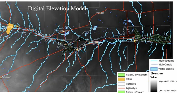
(3) Basin-scale stream-aquifer modeling of the Lower Arkansas River, Colorado. 3. Basin Scale Artificial Neural Network Development. Artificial neural networks are "massively parallel interconnected networks of simple elements and their hierarchical organizations which are intended to interact with the objects of the real world in the same way as biological nervous systems do", or simply a "system of interconnected computational units" (Kirby 1993). 3.1. Spatial-Temporal Database Complex stream-aquifer relationships are highly dependent on numerous explanatory variables in time and space, requiring development of an extensive spatial-temporal database. The spatial database (Figure 1) consists of hydrographic information for the study area such as river and stream channels, lakes, canals, digital elevation model (DEM), soil types, land use maps and irrigated fields map. The temporal database consists of measured time series of flow rates at stream gauging stations, pumping wells, and diversion structures, as well as reservoir storage volumes. Spatial-temporal information is collected from output generated by the GMS Groundwater Modeling System (Boss International, Inc. and Brigham Young University) based on MODFLOW runs that relate factors affecting recharge and pumping events to river depletion or accretion. The geographical location of cells in the finite difference groundwater model grid provides a means of associating modeled aquifer-stream processes with the database (Figure 2). NEXRAD also provides spatial-temporal precipitation data.. Digital Elevation Model. Figure 1 - Spatial database sample. 3.2. Explanatory Variables A key component in the ANN training for basin scale application is the selection of the explanatory variables. The challenge is to select variables that capture physical and spatial features that affect the aquifer-stream interaction and at the same time are measurable or can be estimated at the basin scale.. 233.
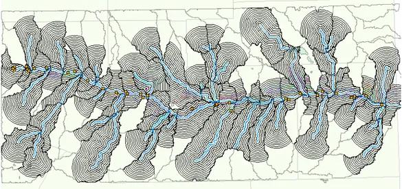
(4) Triana, Labadie and Gates. Groundwater Model grid. Figure 2 - Spatial-temporal database. The role of the explanatory variables is providing information concerning known system states to use in predicting stream returns or depletions. The spatial distribution of the explanatory variables is embedded in the ANN by grouping them in buffer-areas within the alluvial valley, defined relative to their distance from stream segments. The temporal variability for each bufferarea is aggregated into the weekly time steps used in the groundwater model. Figure 3 illustrates an example of the buffer-area distribution around a river segment. The current selected explanatory variables per buffer-area are: • Diverted irrigation water: Calculated as the canal total water diverted per unit irrigated area, multiplied times the irrigated area in each bufferarea. • Pumped water: Calculated as the total weekly volume pumped by wells in each buffer-area. • Average land surface slope: Calculated over the buffer-area using the DEM. • Canal length: Total length of irrigation canals within the area-buffer. • Precipitation: Calculated as weekly average precipitation over the bufferarea from NEXRAD. 3.3. Artificial Neural Network Training Gates et al. (2002) applied GMS to a portion of the Lower Arkansas River basin in Colorado. The initially developed steady-state model has been further calibrated as a transient model over a 133 week period using an extensive field data collection effort, which makes it a unique tool to accurately represent stream-aquifer interaction in the modeled region. The main river channel in the study region is divided into segments. The most significant stresses that explain stream-aquifer interaction within a 234.
(5) Basin-scale stream-aquifer modeling of the Lower Arkansas River, Colorado. River section. Figure 3 - Basin characteristics grouped by buffer-areas. particular segment are assumed to occur in the adjacent surface drainage area. Figure 4 shows the distribution of the segments and their area-buffers across the Lower Arkansas River basin. Using the areas that at least partially intersect the modeled region, input-. Figure 4 - Lower Arkansas River basin area-buffers 235.
(6) Triana, Labadie and Gates. output relationships are extracted for the ANN training. The training data set for each stream segment consists of the explanatory variables for each bufferarea within the segment and the modeled subsurface return/depletion flows aggregated for each river segment as calculated using the further extended Gates et al. (2002) model. The available data sets are separated into three separate groups for training, validation, and testing. The validation data sets are used to prevent overtraining during the training stage. After training, weekly return flow volumes per unit length of stream [(m3/week)/m] are predicted with a coefficient of determination (r2) of 0.81 when predicting combined training and validation input data. Testing data sets are used to measure the trained ANN prediction capability using new inputs. Figure 5 shows predicted vs. GMS model-calculated return/depletion values during the ANN testing phase. Statistical analysis reveals a performance with a coefficient of determination of the same order of magnitude as the training/validation stage, which provides confidence in the predictive capabilities of the ANN in the same areas where it is trained. The average residual error from the testing prediction is 1.6 [(m3/week)/m], with a Figure 5 - ANN testing with new input data sets standard deviation of 19.9[(m3/week)/m]. 3.4. ANN Application Outside Training Areas Using relationships captured by the ANN within the modeled area, the tool is applied for predicting stream-aquifer interactions in the vicinity of the modeled region. Even though the ANN inputs are normalized, one of the greatest difficulties is that inputs from outside areas can have different ranges of input values depending on the size and shape of the watershed. Attempting to visualize errors in the trained ANN predictions outside of the training area involves reserving a portion of the modeled stream segments for the testing stage. Experimentation shows that predictions are less accurate when using the tool for areas of different sizes and shapes. Even though the results give low coefficients of determination, the predictions provide acceptable return flow values and trends. An example of the predictions outside of the training area 236.
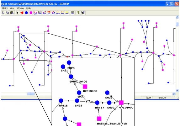
(7) Basin-scale stream-aquifer modeling of the Lower Arkansas River, Colorado. is illustrated in Figure 6. The results provide confidence that the proposed tool will be able to reasonably predict return/recharge flows in a basin scale model. The prediction residual errors outside the training area show a mean of -11.5 [(m3/week)/m], with a standard deviation of 15.3[(m3/week)/m]. Ongoing research will describe uncertainty derived from prediction errors.. Figure 6 - ANN return flow prediction outside of the training areas. 4. Conjunctive Use Basin Scale Model. The spatial/temporal database is used to construct the hydro-network, which contains interconnected nodes representing reservoirs, system water demands, monitoring points, diversion points, and collections of surface drainage points and points of aggregation of groundwater return flows. Many monitoring points in the network have measured data associated with them. Figure 7 shows the hydro-network with geo-referenced features. The georeferenced hydro-network provides the basis for the MODSIM network, with Figure 8 displaying a MODSIM schematic representation of the same portion of the system detailed in Figure 7. Monitoring Points. Reservoirs. System Water Demands Groundwater Return Points. Figure 7 – GIS Hydro-Network 237. Water Diversion Point.
(8) Triana, Labadie and Gates. Figure 8 – Example of MODSIM system representation.. 4.1. Calibration Phase During the calibration phase, the goal is to simulate the system as closely as possible to the historical operation. The MODSIM graphical user interface (Figure 8) allows construction of the river basin network structure, and specification of physical characteristics, water right decree amounts and dates, and import of all available measured sources of water. 4.1.1 Hydrologic Calibration The study region is divided into reaches or segments between gauging stations for easier analysis. The calibration allows identification of unmeasured water gained and lost for each reach using measured flow in the river and major tributaries and diversion records. It can also reveal system characteristics, additional features, and special operations. The previously trained ANN is embedded in the MODSIM solver using a VB.NET routine for predicting the stream-aquifer interaction in interaction with the MODSIM solution for flow allocation. Maximum possible runoff for each subwatershed as the total volume of rain in the sub-watershed is estimated using NEXRAD spatial hourly precipitation data. The MODSIM network topology allows addition of these runoff estimates as unregulated inflow at each subwatershed outlet node. In general, preliminary results showed significant unmeasured amounts of water being returned to the river in addition to the predicted groundwater return. The measured runoff from tributaries and the calculated return flow (as the difference between the flows at the gauging stations minus the diversion records) show the same trend (Figure 9). However, there was not an observable strong correspondence between them, suggesting that it will be 238.
(9) Basin-scale stream-aquifer modeling of the Lower Arkansas River, Colorado. necessary to better quantify unmeasured runoff from rainfall. The return flow volume calculation for the reach between stations ARKROCCO and 07123000 in the Arkansas River using only the measured tributaries’ contributions is shown in Figure 9.. Figure 9 - Observed and predicted water return volumes. Analysis of these reaches will allow identification of special system operations and potential inaccuracies in the field data. For example, the large negative peaks in Figure 9 could indicate missing data in the historical diversion records or large-scale pumping in the vicinity of the river, among other possibilities.. 5. Conclusions and Future Work. Results indicate that ANN is a valuable tool for predicting stream-aquifer interactions in the modeled region using relationships extracted from input variables available basin-wide. Application of the trained ANN in the vicinity of the groundwater modeled region show low correspondence between ANNpredicted and GMS-calculated return/depleted flows; however, the predictions have an acceptable order of magnitude and trends. Future work will attempt to improve the ANN prediction outside of the modeled region by redefining the way that the spatial explanatory variables are grouped, and making them more even in size and shape; using more than one modeled region to train the ANN (application to a region of the valley between Lamar and the ColoradoKansas border is currently underway); extending the current modeled period to increase the training/testing datasets and to cover a wider variety of climatic conditions; and adding other explanatory variables (for example, depth to bed rock of the shallow aquifer, and aquifer transmissivity). The tool presented herein shows that it is possible to embed ANNs in the MODSIM solver to build an alternative solution for modeling conjunctive water use at basin scale. The solution bases its ability to predict return/depleted flows on capturing the aquifer-stream relationships from a well-calibrated finite difference model, and using these relationships to predict 239.
(10) Triana, Labadie and Gates. interactions in non-modeled areas. This approach addresses problems faced in basin scale modeling such as a large computational burden when using finite difference models, and use of simplified lumped response functions dealing with groundwater return flows. Future work includes better estimation of unmeasured surface runoff, development of diversion rules based on climatic conditions, and incorporation of more complex system operations and conservative constituent quality modeling inside MODSIM (MODSIMQ). MODSIMQ will provide the ability of modeling strategies to support a productive irrigated agriculture in the basin while complying with state water law and interstate compacts. Acknowledgements. The support of the United States Department of Agriculture, the Colorado Water Resources Research Institute, the US Geological Survey, and the Colorado Agricultural Experiment Station for this research is gratefully acknowledged.. References Fredericks, J. and J. W. Labadie, 1995: Decision support system for conjunctive streamaquifer management. Completion Report, Grant No 14-08-0001-G1551-04, Proj. No. 03, Colorado Water Resources Res. Inst.Completion Report, Grant No 14-08-0001-G1551-04, Proj. No. 03, Colorado Water Resources Res. Inst. Fredericks, J., J. Labadie, and J. M. Altenhofen, 1998: Decision support system for conjuntive stream-aquifer management. Water Resources Planning and Management, ASCE, 124, 6978. Gates, T., J. Burkhalter, J. Labadie, J. Valliant, and I. Broner, 2002: Monitoring and Modeling Flow and Salt Transport in a Salinity-threatened Irrigated Valley. Journal of Irrigation and Drainage Engineering, 128(2), 87-89. Kirby, M., 1993: Neural networks and function approximation. Classnotes from lectures on Neural Networks. Colorado State University. Triana, E., J. W. Labadie, and T. K. Gates, 2003: Stream-Aquifer Interaction Modeling Using Artificial Neural Networks. World Water and Environmental Resources Congress, Philadelphia.. 240.
(11)
Figure


+4


Related documents
Vi hade en uppfattning om hur vi skulle kunna använda oss av skönlitteratur i både svenska och matematik men vi behövde mer kunskap om vad skönlitteratur kan
39 The reports regarding transfer pricing published by the OECD can therefore be assumed to have a substantial international value as source of interpretation unless the
To execute network tests, a packet engine suite is used consisting of a network traffic generator that is used for creating a packet stream, as well as a traffic receiver that
Data on vertebral body dimensions (height, width, depth, spinal canal diameter, facet joint angles) have been compiled from biomechanical literature. Significant gender
Vi utgick då från våra frågeställningar om hur arbetet med pedagogiska utredningar för elever med läs- och skrivsvårigheter beskrivs samt vad en pedagogisk utredning leder till
I resultatet ovan framkommer det att människor känner olika empati för gärningskvinnan beroende på vilken hårfärg hon har där den rödhåriga kvinnan (hos
Syftet med denna studie är att undersöka varför högskolestudenter använder sociala medier och hur de upplever att hälsan påverkas genom att ständigt vara tillgängliga.. 3.1
Generellt sett ligger också motorvarvtal och bränsleförbrukning högre för alternativen med motorvärmning av smörjoljan samt ingen motorvärmning relativt motorvärmning
