PROPOSAL OF INTEGRATIONS TO THE ITALIAN ROAD
REGULATION ON CYCLE MOBILITY: LEARNING FROM FOREIGN
BEST PARACTICES
Michèle Pezzagno1
University Of Brescia – Faculty Of Engineering (DICATAM) Via Branze, 43 25123 BRESCIA Italy
E-mail: michele.pezzagno@ing.unibs.it
Giulio Maternini2
University Of Brescia - Faculty Of Engineering (DICATAM) Via Branze, 43 25123 BRESCIA Italy
E-mail: giulio.maternini@ing.unibs.it
ABSTRACT
Under many aspects Italy would be ideal for cycling: the wheather is favorable for a good part of the year and many historic centres are characterized by roads which would mainly be suitable for bicycle traffic. The positive aspects relating to cycling are well known, but unfortunately, the use of bicycles in Italy is still poor and the main cause of this phenomenon is certainly relating to a general lack of safety in cycling.
In the last decade, in Italy the trend of road accidents and victims is generally decreasing, but, at the same time, the number of cyclists involved in road accidents increased by 24,5%, therefore, more attention to cyclists as Vulnerable Road Users is absolutely needed.
The causes of this high accident rate is mainly relating to a lack of national legislation or to standards which are old, often overlapped to regional guidelines, uneven, confusing and in some case also contradictory.
In terms of cycle network planning, it should be reminded that in Italy there is no regulation that establishes the criteria for a functional classification of bicycle paths. As a consequence, the infrastructure geometry and facilities (bicycle parking, places of refreshments, cycle repair shops, etc.) are not properly put in relation to the role played by the cycle path in the territory.
In the course of time, we assisted to the realization of isolated cycle path trunks, generally out of a planning strategy and characterized by their own geometry.
Therefore, taking also inspiration by the standards developed in other European Countries, this research tries to provide guidelines for pre-normative functional classification of cycle paths, for their design and planning, in order to obtain safe and homogeneous cycling routes in Italy.
It should be noted that the technical solutions, devices and traffic regulations, adopted in other countries, are very effective for a safe cycle mobility, but need to be revised in relation to the existing Italian law.
1
Michele Pezzagno is author of the chapter n. 3
2
1 ROAD ACCIDENTS TREND RELATING TO NON MOTORIZED
USERS IN ITALY
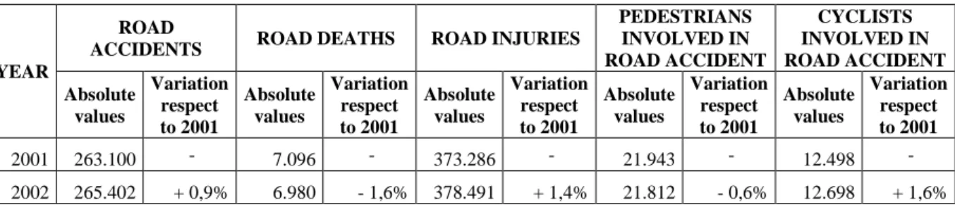
Under many aspects Italy would be ideal for cycling: the wheather is favorable for a good part of the year and many historic centres are characterized by roads which would mainly be suitable for bicycle traffic. Cycling does not produce neither pollutant gases nor noise, it requires little space and it is extremely positive for human health. Unfortunately, the use of bicycles in Italy is still poor and the main cause of this phenomenon is certainly related to a general lack of safety in cycling. It would be interesting to correlate road accident data involving cyclists with the distance cycled, but unfortunately data concerning the mileage covered by cyclists in Italy are not available at National level, as recently confirmed in the ETSC study “Pedalling towards Safety”. The Italian Observatory Audimob ISFORT in 2012 published a statistical report focusing on cycle mobility. The interesting aspect emerging from the report is that the percentage of people using bicycle as mode of transport decreased from 4% out of the total number of movements registered in 2006 (corresponding to the maximum value in the recent past) to 3,3% in 2011. This could be due to the sensation of unsafety perceived by cyclists moving on facilities which are not suitable to their movements, causing a progressive abandon of the cycling habits. As a matter of fact, in Italy the trend of road accidents and victims is generally decreasing, while, at the same time, the number of cyclists involved in road accidents in the last decade increased by 24,5% (see Table 1). Therefore, more attention to cyclists as Vulnerable Road Users (VRUs) should be paid in our Country.
The causes of the high accident rate can be manifold: they cannot be considered related only to the "irresponsible" cyclists’ behaviour. Instead, they are mainly related to a lack of national legislation and standards which are old, often overlapped to regional guidelines, uneven, confusing and in some case also contradictory.
In terms of cycle network planning, it should be reminded that in Italy there is no regulation that establishes the criteria for a functional classification of bicycle paths. As a consequence, the infrastructure geometry and facilities (bicycle parking, places of refreshments, cycle repair shops, etc.) are not properly put in relation to the role played by the cycle path in the territory.
In the course of time, we assisted to the realization of isolated cycle path trunks, generally out of a planning strategy and characterized by their own geometry and facilities.
Therefore, taking inspiration also from the standards of other European Countries, this research tries to provide guidelines for pre-normative functional classification of cycle paths, for their design and planning, in order to obtain safe and homogeneous cycling routes in Italy.
Table 1 Road accidents trend in Italy from 2001 to 2010 and focus on VRUs involved in road accidents. Source: ISTAT (National Institute of Statistics online data warehouse
http://dati.istat.it/)
YEAR
ROAD
ACCIDENTS ROAD DEATHS ROAD INJURIES
PEDESTRIANS INVOLVED IN ROAD ACCIDENT CYCLISTS INVOLVED IN ROAD ACCIDENT Absolute values Variation respect to 2001 Absolute values Variation respect to 2001 Absolute values Variation respect to 2001 Absolute values Variation respect to 2001 Absolute values Variation respect to 2001 2001 263.100 - 7.096 - 373.286 - 21.943 - 12.498 - 2002 265.402 + 0,9% 6.980 - 1,6% 378.491 + 1,4% 21.812 - 0,6% 12.698 + 1,6%
YEAR
ROAD
ACCIDENTS ROAD DEATHS ROAD INJURIES
PEDESTRIANS INVOLVED IN ROAD ACCIDENT CYCLISTS INVOLVED IN ROAD ACCIDENT Absolute values Variation respect to 2001 Absolute values Variation respect to 2001 Absolute values Variation respect to 2001 Absolute values Variation respect to 2001 Absolute values Variation respect to 2001 2003 252.271 - 4,1% 6.563 - 7,5% 356.475 - 4,5% 20.430 - 6,9% 12.804 + 2,4% 2004 243.487 - 7,5% 6.122 - 13,7% 343.177 - 8,1% 20.770 - 5,3% 13.231 + 5,9% 2005 240.010 - 8,8% 5.818 - 18,0% 334.855 - 10,3% 21.161 - 3,6% 14.127 + 13,0% 2006 238.121 - 9,5% 5.669 - 20,1% 332.947 - 10,8% 21.820 - 0,6% 14.977 + 19,8% 2007 230.868 - 12,3% 5.131 - 27,7% 325.847 - 12,7% 21.152 - 3,6% 15.713 + 25,7% 2008 218.963 - 16,8% 4.725 - 33,4% 310.745 - 16,8% 21.288 - 3,0% 15.636 + 25,1% 2009 215.404 - 18,1% 4.237 - 40,3% 307.254 - 17,7% 20.993 - 4,3% 15.874 + 27,0% 2010 211.404 - 19,6% 4.090 - 42,4% 302.735 - 18,9% 21.981 + 0,2% 15.565 + 24,5%
It should be noted that the technical solutions, devices and traffic regulations, adopted in other countries, are very effective for a safer movement of cyclists, but need to be revised in relation to the existing Italian law.
2 MAIN SHORTCOMINGS RELATING TO THE ITALIAN LAW
CONCERNING CYCLE MOBILITY
The current laws in Italy concerning cycle mobility consist of a brief regulation, which derives from the Italian Law n. 366 (19/10/1998) “Rules for the cycle mobility financing” and which was issued through a Ministry Decree (DM 557 30/11/1999 “Regulation for the cycle paths technical features definition”). The 1998 Law (Art.2) pushed Regional Administrations to produce their own local regulations/guidelines: since the early two-tousands the Italian northern Regions issued their own regulations concerning the the realization of cycle itineraries, introducing heterogeneous approaches. Lombardia Region, for example, in 2000 published an extensive manual concerning the only regional cycle network and taking inspiration from the North Europe current Directives, proposing solutions which were not properly calibrated to the Italian urban environment. A neighbouring Region (such as Piemonte), following a different conceptual approach, in 1997 published a first technical manual, in which, for example, criteria based on the motorized vehicle traffic and the vehicle speed were used for the selection of the most suitable kind of cycle facility, including also the dimensional aspects. As a consequence of this heterogeneous framework, the innovative approaches proposed by the Regions were scarcely applied, this make evidence of the importance of common guidelines to be set up at national level.
The present chapter will analyse some of the articles composing the current national law concerning the cycle mobility (DM 557/1999), pointing out its main shortcomings.
Art. 1 reports the description of the technical features which characterize the cycle facilities, the guidance to design them and the quality aspects they have to reflect. Art. 1 talks also about “guidance to design cycle facilities”, but does not give any particular indication to differenciate them or to classify them according to their function. On the contrary, a functional classification of cycle facilities would be fundamental in order to properly design them.
Paragraph a) of the Art. 3 introduces the “Cycle Network Plan", including it among the detailed plans composing the Urban Traffic Plan (PUT). PUTs were introduced by the New Highway Code (NCdS, 1992) and should be elaborated by Municipalities with more than 30.000 inhabitants (or by Municipalities selected at Regional level). The duty of drawing up PUTs is still now disregarded, notwithstanding the presence of national directions for their elaboration (in 1995 the then Ministry for the Public Works issued the “Directives for the elaboration of PUTs”). These directions are partially obsolete (for example they do not mention traffic calming techniques) and should be revised, considering the experience of some Italian Administrations (at Municipal or Provincial level) in the field of the cycle itineraries planning or in the Urban Mobility Planning (PUMs), taking inspiration from the European Sustainable Urban Mobility Plans (SUMPs) elaboration process. The publication of national directions for the Cycle Mobility Plans elaboration is therefore fundamental, specifying also how these Plans should be integrated to the other urban/transport planning tools.
Four kind of cycle facilities are defined (ref. Art. 4 in DM 557/1999): two of them are separated cycle paths, the other two are shared-use facilities. As there is not any reference to the kind of function played by each kind of facility in the territory, not even the conditions for their realization are explained: realizing a cycle lane deriving it from the traffic through lane seems to be alternative to realizing a cycle path deriving it from the sidewalk. The choice of implementing one of the presented solutions seems to depend only on the availability of sufficient space, disregarding the surrounding functions, the urban fabric and the cycle traffic volumes. For example, in a “30 km/h zone” (20 mph zone) the best solution would be to realize a cycle lane deriving it from the traffic through lane, while near to primary schools the best solution would be to realize a cycle path deriving it from the sidewalk.
According to DM557/1999 two kind of shared-use facilities are defined: cyclists-pedestrians and cyclists-motorized traffic. The law considers this latter solution as extremely dangerous for cyclists, while the implementation of traffic calming measures could guarantee sufficient safety conditions for cyclists which move together with the motorized vehicles.
The law suggest that that promiscuity between pedestrians and cyclists should be preferred but, especially in urban areas, were pedestrian flows are considerable such solution could generate dangerous situations if the shared path is not properly designed and dimensioned. As a matter of fact in Italy there is a general inadequate quality of the shared-use facilities and the different operating speeds/travel behaviours of these two kinds of users make their movement uncomfortable and unsafe especially for pedestrians. Therefore, the pedestrian-cyclist shared facilities should be considered as exceptional solutions to be proposed only after a proper design and dimensioning and in many cases should even be avoided, coherently with the European technical regulations.
Paragraph 1 of the Art. 9 in DM 557/1999 is dedicated to the pedestrian/cyclist crossings and implies that cyclists and pedestrians crossing the street usually adopt the same behaviour. This statement is not true, as cyclists are characterized by dynamic features (in terms of mass and speed) which are extremely different from pedestrians. Sometimes cyclists drive bicycles completely disregarding the presence of pedestrians (especially on shared spaces) and without considering the inconveniences caused to their circulation. The unsafety perceived by pedestrians (especially by elderly people) makes the facility uncomfortable and in some case significantly affects their frequentation.
3 PROPOSAL FOR THE NON MOTORIZED ITINERARIES
FUNCTIONAL CLASSIFICATION
Non motorized road users often share the space along facilities, either in urban or in extra-urban areas. Networks dedicated to “soft mobility” (i.e. non motorized mobility, either for systematic or unsystematic purposes such as walking, cycling, skating, etc) are usually separated from motorized users (for safety reasons), but allows the promiscuity among non motorized users. As already mentioned in the previous chapter, the shared use of certain facilities can bring to conflicts and unsafe situations: the incompatibility between pedestrians and cyclists is particularly evident when flows are high and when one traffic component prevails on the other one. Let’s consider for exampler the case of a downtown area closed to motorized traffic: the presence of considerable pedestrian flows can seriously affect the cyclists’ movements; on the contrary, if we consider the case of a rural path massively frequented by cyclists, the presence of pedestrians can impede cyclists and can be extremely dangerous for the pedestrians themselves. Another kind of conflict is represented by the incompatibility of the two kind of users in terms of operational speed: on average, pedestrians move at 3 – 5 km/h, while cyclists at 15 – 20 km/h.
Art. 2 of the New Italian Highway Code (NCdS, 1992) defines and classifies roads basing on their geometric, technical and functional features. This classification allows to determine the roads geometry, dimensions, compatible intersections, admitted users, parking regulation, etc., but is valid only for facilities open to motorized traffic and is suitable to its needs.
In Italy such kind of classification does not exist for “soft mobility” networks, but it would be of extreme importance for their planning and for the integration of functions at urban and territorial level. An accurate soft mobility classification and planning would allow to reflect non motorized users’needs and features and to re-think the geometric characteristics and the standards for the facilities design.
Art. 4 reports different kind of cycle facility, but this classification takes into account only the technical features, disregarding the function assumed by the facility itself in the surrounding urban and rural territory. This is the reason why, in the following subheadings, a functional classification of the “Soft Mobility” networks is proposed, i.e. the the cycle facilities which belong to non-motorized itineraries (greenways) will be classified according to their function.
In the recent past, the scientific community already highlighted the shortcomings in the Italian laws and several publications presented proposals for the non motorized itineraries classification, but such proposals mainly adopted an urban planning approach, which is almost exclusively focused on the urban functions optimization, disregarding the transport-oriented approach. This latter is adopted only in few cases and only for some kind of networks, giving only a partial vision of the problem. Some classifications are made according to the kind of user, some others according to the covered distances (short, medium, long) or basing on the kind of function/use, therefore it is difficult to synthesize them in a comprehensive classification, able to take into considerations all the aspects mentioned above.
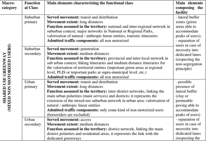
In the light of the law shortcomings, it is important to provide an organic overview of the non motorized network classification. In order to do that, the classification already proposed by Maternini and Pezzagno in the Nineties for the greenways was taken as reference and deepened (Maternini & Pezzagno, 1999, 2000). According to this classification, non motorized itineraries can be divided into two macro-categories: shared-use greenways (when non motorized users share the facility) and exclusive-use greenways, dedicated to single types
of non motorized users (see Table 2). This distinction is coherent with the Italian law DM 5/11/2001 “Geometric and functional regulation for the road design”, which provides the respective main elements according to the road classes (the typology and the extent of the served movement, the function assumed in the territory and the admitted kind of users etc.).
The second macro-category of greenways includes the case of separated pedestrian itineraries or single cycle paths.
Facilities belonging to the first macro-category of greenways should be planned and designed taking as reference a minimum level of service in relation to the number of passing or meeting events (TRB, 2010): as a matter of fact, on the one hand the vitality of a shared path is absolutely desirable (from which its social attitude derives), on the other hand, an excessive number of passing/meeting events can cause the abandon of the facility itself. The non-segregation principle should also be considered, which can be crucial in terms of social security perception in the off-peak time periods. According to this principle, users should be separated into adjacent lanes (not necessarily through the use of physical barriers) but would not be isolated.
Under particular conditions, such as in urban areas, non motorized mobility networks should avoid shared solutions, as they serve systematic movements, therefore it is more desirable to separate pedestrians from cyclists. Similarily, in extra-urban areas, itineraries are often frequented for recreational/sport purposes; therefore, facilities need to be exclusive for single kind of users and equipped with special solutions. Such facilities should be planned taking as reference a minimum level of service according to the served user.
Table 2: Classification proposal for the Italian “Soft Mobility” network (green ways)
Macro-category
Function al Class
Main elements characterizing the functional class Main elements
composing the facility S H A R E D US E G RE E NW AY (M IXE D NO N M O T O RIZ E D US E RS ) Suburban primary
Served movement: transit and distribution Movement extent: long distances
Function assumed in the territory: national and inter-regional network in suburban context; major networks in National or Regional Parks,
valorisation of natural / anthropic linear entities, touristic itineraries Admitted traffic components: all non motorized
- lateral buffer zones (green areas able to accommodate peaks of users); - separation of users in case of necessity into dedicated lanes (respecting the non-segregation principle) Suburban secondary
Served movement: penetration Movement extent: medium distances
Function assumed in the territory: provincial and inter-local network in sub urban context; hiking itineraries and medium distance itineraries for the valorisation of territorial entities (important green areas at regional level, PLIS or important parks at supra-municipal level, etc.)
Admitted traffic components: all non motorized Urban
primary
Served movement: transit and distribution Movement extent: long distances
Function assumed in the territory: inter-district networks, linking the main urban polarities (main services) and districts; it represents the extension of the mixed use suburban network in urban area; valorisation of natural / anthropic linear entities
Admitted traffic components: only some kind of non motorized users (horseriders are excluded)
- possible presence of lateral buffer (clay or permeable paving able to accommodate peaks of users) - separation of users in case of necessity into dedicated lanes (respecting the Urban secondary
Served movement: access
Movement extent: medium distances
Function assumed in the territory: district network, linking the main district polarities and residential areas, it represents the link with the dedicated greenways
Macro-category
Function al Class
Main elements characterizing the functional class Main elements
composing the facility
Admitted traffic components: only some kind of non motorized users (horseriders are excluded)
non-segregation principle) E XCL US IVE US E G RE E NW AY (S ING L E NO N M O T O RIZ E D US E RS
) Suburban Served movement: penetration at territorial level Movement extent: medium and long distances Function assumed in the territory: itineraries for special
recreational/sport activities (mountain paths, ski slopes or trails, down-hill tracks, bird watching tours, etc.)
Admitted traffic components: single categories of non motorized users
- equipements change according to the admitted traffic component /network use
Urban Served movement: flowing and distribution
Movement extent: medium and long distances
Function assumed in the territory: for systematic traffic flows, linking urban polarities such as main services, district services and residential areas Admitted traffic components: single categories of non motorized users
Table 3: Elements characterizing the Italian “soft mobility” network (greenways)
S H ARE D US E G RE E NW AY
Italian Law does not provide any parameter for the greenway characterization. The analysis of the international literature provide the following standard characterizing the network. The proposed minimum parameters are adapted from the ones used in the Washington County (Uniform road improvement design standard)
MINIMUM PARAMETERS OBJECTIVE/NOTE
Width Useful width
L=1,80 m
The objective is to make passing/meeting events possible. The provided width refers to passing/meeting events between cyclists and pedestrians. Buffer width Lb=0,60m ÷
1,50m For each side
The buffer width should allow the users movements in case of overcrowding problems on the network, therefore it should be free of obstacles (except punctual objects)
Total Width Lc=L+Lb The total width is variable, according to the buffer width
Length 900 m Below the proposed value the itinerary is not significant in terms of
facility
Free Height 2,90m The free height parameter is foundamental for the movement quality: it
allows high visibility of the incoming users and safe movements for cyclists and horse riders.
Level of service (LOS)
C For security reasons the maximum LOS for greenways should be B. With
a D LOS cyclists are disadvantaged and with a E LOS cyclists tend to abandon the network.
Prevailing kind of mobility
Non systematic Non systematic mobility characterizes shared-use greenways, either in urban or in suburban context. In urban areas they are mostly conceived as “social green networks complementary to the systematic mobility networks (exclusive use greenways).
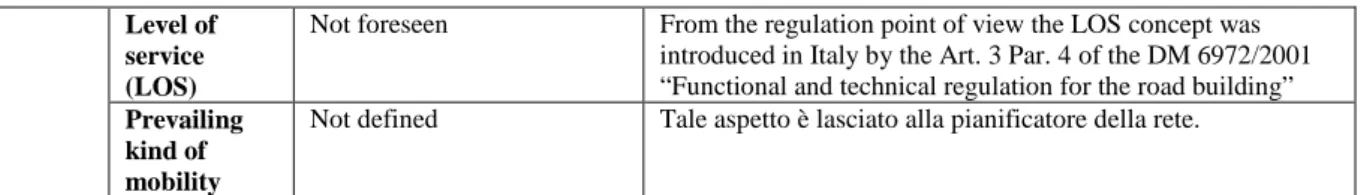
E XCL US IVE US E G RE E NW A Y ( fo r cy cl is ts )
The following example reports the minimum parameters taken from the Italian DM 557/1999 “Regulation for the cycle paths technical features definition”. It is evident that the cycle lane/path width is the main parameter for the itinerary sizing.
MINIMUM PARAMETERS OBJECTIVE/NOTE
Width 1,50m for mono-directional
cycle paths (reducible to 1,00m for a limited extent; 2,50m for adjacent cycle lanes (in the same or opposite direction)
Minimum dimensions do not depend on the kind of cycle itinerary, on the cyclists flows or on the passing/meeting events between two cyclists.
Buffer width Not defined DM 557/1999, Art.7 mentions the median width. The
minimum value for medians which separate a cycle paths from the carriageway is 0,50 m.
Length Not defined
Free Height Not defined Such information can be found in the local building regulation
elaborated at municipal level, referring for example to the interactions between pedestrian flows and shops curtains (minimum height (2,10m÷2.40m)
Level of service (LOS)
Not foreseen From the regulation point of view the LOS concept was
introduced in Italy by the Art. 3 Par. 4 of the DM 6972/2001 “Functional and technical regulation for the road building” Prevailing
kind of mobility
Not defined Tale aspetto è lasciato alla pianificatore della rete.
4 PROPOSAL FOR THE NATIONAL LAW MODIFICATION
The following paragraphs show the modification that could be made to the Italian current regulation, taking inspiration from some international best practices.
4.1 “Surmountable” cycle itineraries definition
Italian law (DM 557/1999) foresees only four types of cycle itineraries and does not present any other facility dedicated to the cycle mobility, while, on the contrary, it would be desirable to find out other type of cycle facilities to better fit with some contexts, expecially urban areas.
For example, in Germany (RASt, 2006) and in The Netherlands (RVV, 1990) there are “cycle lanes adjacent to the carriageway”, i.e. cycle lanes which are narrower than the standard cycle path size and are signalized through a dashed longitudinal line. This lane is reserved to cyclists, cannot be used by vehicles, but can exceptionally be invaded when large vehicles meet (buses or trucks).
This solution provides a light level of protection toward cyclists and can be used when a portion of road needs to be dedicated to cyclists but there is not space enough to realize a regular cycle lane, being more desirable than the shared space cyclists-vehicles.
Figure 1: Dashed lines which guide drivers at intersections. (Source: “Regulation to the Highway Code”)
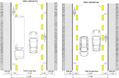
This solution reduces the traffic lanes width, which cannot be marked through a median line as, according to the Italian Highway Code (NCdS, 1992), they are not wide enough. In foreign Countries where this solution is foreseen by the law, a “surmountable cycle lane” is marked through a white dashed line, as it is surmountable by large vehicles when necessary. Italian law does not foresee this kind of horizontal signing, but, taking inspiration by the dashed lines which guide drivers at intersections according to the Regulation to the Highway Code (Figure 1), similar lines to guide cyclists should be introduced, using the color generally used to indicate cycle paths (yellow) and using a dashed line.
Figure 2 presents two applications of the proposed solution: cycle lanes 1,00 m wide adjacent to the traffic through lanes along both the sides of the road. This solution is valid for roads where the speed limit is 30 km/h, where traffic flows are scarce and when the carriageway is 6,00 m to 7,50 m wide.
Figure 2: Delimitation of a surmountable cycle lane inside the carriageway: on the left a large vehicle invades the cycle lane when meets a vehicle; on the right two vehicles meet without invading the cycle lane.
4.2 One-way streets except for cyclists
In Italy, in one-way streets cyclists cannot circulate in the opposite way, according to the Highway Code. In some other countries (in The Netherlands, Germany, Switzerland) cyclists can move in the opposite direction respect to the one-way road in order to grant the cycle network continuity. Notwithstanding the law, in Italy, especially in historical city centres many cyclists circulate against the traffic flow anyway. Therefore, it is evident the necessity of adjusting the Italian regulation. Recently, the Ministry for Infrastructures and Transport expressed a favourable advice towards the circulation in both the directions for cyclists under particular conditions (presence of limited traffic zones, reduced speed, etc.), without giving any technical detail.
The Dutch handbook CROW3 admits the following solution: along a one-way street 30 km/h speed limited, characterized by low level of traffic (less than 5.000 vehicles/day) cyclists share the road with the vehicles in both the directions.
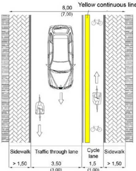
According to the recent Ministerial advice and the Dutch good practice, the cyclists circulation against the traffic flows in one-way roads should be admitted only in case of 30 km/h speed limited roads and in a separated cycle lane, while cyclists moving in the same direction of the other vehicles should share the traffic through lane (Figure 3).
Figure 3: One way road where the cycle lane is dedicated to the cyclists which move against the traffic flow (measures into brackets are minimum dimensional parameters).
3
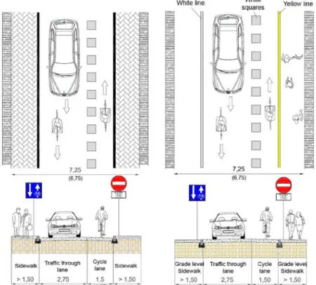
Figure 4: Schemes and road sections of a one-way street in a city centre where cyclists can move against the traffic flow in a cycle lane indicated by 0,50 m wide squares (measures into brackets are minimum dimensional parameters).
The traffic lane, shared-used by cyclists and drivers moving in the same direction, should be or larger than 3,50 m or narrower than 3,00 m. According to the German and the Dutch experience, intermediate widths are discouraged, as in case of passing events (between vehicles or between a vehicle and a cyclist) the traffic lane would not be wide enough to respect safety distances, therefore they are not suitable for a shared-use of the road.
Traffic lanes width lower 3,00 m inhibit passings or movements side by side, therefore cyclists circulate in safe conditions.
Roads in city centres usually have reduced width and sometimes there is not space enough to realize regular cycle lanes adjacent to the traffic lanes. In these cases, cycle lanes could be realized, deriving them from the traffic lanes delimiting them through dashed withe lines composed by 0,50 m wide squares according to the Fig. II 437 Art. 146 of the Regulation to the Italian Highway Code (see Figure 4 - left).
Figure 4 (right) shows a rcity centre one-way road where the sidewalk is grade-level and is separated by the cycle lane through a continuous (unsurmountable) yellow line. The visibility of the cycle itineraries should be improved by installing surmountable leds along the cycle lane.
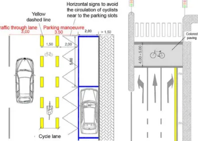
4.3 Parking slots adjacent the carriageway
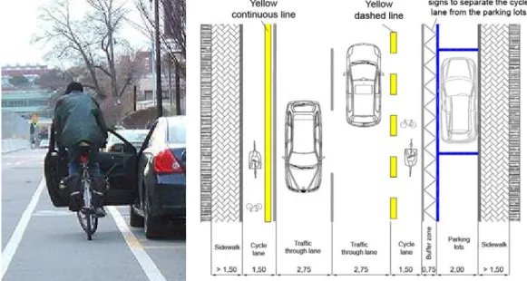
One of the most frequent road accident scenario involving cyclists is the doors opening of a parked vehicle (see Figure 5-left). The Italian DM 577/1999 does not foresee any technical solution to this problem, while many foreign Countries foresee a protection band between the
parking slots and the cycle lane. The typical dimension of this safety buffer is about 0,75 m. This configuration should be proposed in Italy for the cycle lanes running alongside on road parking. The protection band should be highlighted through a differed paving or horizontal signs, in order to prevent cyclists from moving to close to parked vehicles (see Figure 5-right)
DM 6792/2001 foresees that roads belonging to class E (urban district roads) schedule a manoeuvre lane between the parking slots and the traffic lanes. The manoeuvre lane should be 3,50m wide for parallel on road parking and 6,00m wide for perpendicular parking (intermediate width are for oblique parking slots).
Figure 5: (left) Impact between the opening door of a parked car and an incoming cyclist moving on a cycle lane adjacent to on road parking lots; (right) Scheme of a local urban road where a 0,75m wide buffer zone separates cyclists from parked vehicles.
The manoeuvre lane width could be used not only for the original purpose of serving parking manoeuvres, but also to serve cyclists movements: Figure 6- left shows a 1,5 m wide cycle lane derived from the manoeuvre lane, leaving 2,00 m for the buffer zone. The cycle lane is highlighted using a longitudinal dashed (surmountable) yellow line.
Figure 6: (left) Scheme of urban district road where the manoeuvre lane serving the on-road parking is partially occupied by a cycle lane; (right) Example of signalized intersection with an extended bicycle area.
4.4 Extended Bicycle Area at signalized intersectionsa
Intersections are critic sites, where cyclists often conflict with other road users: Italian law is inadequate on this issue and does not provide solutions able to meet the cyclists’ needs.
Along cycle itineraries, intersections can be equipped with dedicated cycle traffic signals or with pedestrian signals. In this latter case, cyclists should get off the bicycle and cross by walking. Rarely cyclists respect this rule, generating many conflicting situations. At signalized intersections with no traffic lights dedicated to the cycle crossing, cyclists should follow the motorized traffic rules: recently, in Germany, the National Highway Code (StVO, 1970) has been modified according to this advice for safety reasons in favour of pedestrians).
Another solution which is widely adopted in foreign Countries is the Extended Bicycle Area (EBA): at signalized intersections this area allows cyclists to wait for the green light just in front of the vehicles, gaining the priority while turning. This solution is not explicitly foreseen by the law, but is starting to be adopted. The Lombardia Region in 2002 proposed this solution in the “Handbook for the Regional cycle network realization”, highlighting the fact that cyclists spontaneously tend to stop at signalized intersections advancing in front of the vehicles, in order not to breathe exhaust gasses and to take advantage in the turning manoeuvres.
This situation should be regulated at national level, in order to avoid bad applications and to stimulate its application where required. The Dutch manual CROW, alongside the positive aspects relating to the EBAs (such as for example the decrease of the conflicts between vehicles and cyclists), highlights also the negative aspects: one of the main risks concerning EBAs is that vehicles could not respect this area. Another limit is that placing an EBA makes unfeasible the insertion of traffic light phases dedicated to the left turning vehicles. The Dutch manual CROW underlines that if a cycle path is not present outside the carriageway, an on-road cycle lane at least 25,00 m long should be realized before the EBA, in order to help cyclists reaching the area.
The application of this solution in Italy should be limited to the roads where an on-road cycle lane/path is present or is going to be realized. EBA should be 4,00 – 5,00m long, while paving should be differenciated and should report the bicycle horizontal sign (Figure 6-right).
5 CONCLUSIONS
The Italian law concerning cycle mobility is unfortunately characterized by significant gaps, which need to be filled. The national law provides minimum dimension requirements for cycle paths without making considerations concerning the introduction of such kind of facilities in the urban fabric or giving the criteria for the path size adaptation according to the cyclists flows. Alongside this, at Regional level some technical manuals or regulations have been released, but they are characterized by heterogeneous approaches or are focused only on particular kind of cycle facilities. This fragmentary panorama brought to the realization of discontinuous interventions and characterized by scarce quality, together with shortcomings in the technicians training process. Hence the necessity to develop this issue at academic level, aiming at proposing an improvement of the existing set of laws and taking inspiration from the most consolidated best practices in the international framework.
REFERENCES
Osservatorio Audimob ISFORT (ed) (2012). Pedalare sì, ma per diletto. In ACI, Ondaverde n. 138, July/August 2012.
Austroads (2011). Cycling aspects of Austroads Guides, Australia.
Baudirektion Kanton Zurich (2004) Anlagen fur den leichten zweiradverkehr, Switzerland. CROW (2007). Design manual for bicycle traffic, The Netherlands.
Danish Road Directorate (2000), Collection of Cycling Concepts, Danimarca.7 ETSC (2012). Pedalling towards Safety, Brussels.
Maternini G., Pezzagno M., (1999). The greenways in urban and territorial planning. Proceedings of the IV International Congress “Energy, environment and technological innovation”, Universidad Central de Venezuela, Università di “Roma tre” e Università di Roma “La Sapienza”, Roma, 19-24 September 1999.
Maternini G., Pezzagno M., (2000). La progettazione delle greenway. In Le Strade, n.1-2, La Fiaccola Editrice.
Maternini G., Foini S. (eds) (2007). Tecniche per la sicurezza in ambito urbano - Criteri per
una corretta segnaletica stradale, Volume XI, Ed. EGAF.
Maternini G. (eds) (2012), Tecniche per la sicurezza in ambito urbano – Mobilità ciclistica.
Metodi, politiche e tecniche, Volume XVI, Ed. EGAF.
Ministero dei Lavori Pubblici (1999). D.M. n. 557, 30 Novembre 1999, Regolamento recante
norme per la definizione delle caratteristiche tecniche delle piste ciclabili in G.U. n. 225,
26 settembre 2000, Serie Generale.
RASt (2006). Richtlinien fur die Anlage von Stadtstrassen, Germany.
Regione Lombardia, Direzione generale Territorio e Urbanistica (2002). Manuale per la
realizzazione della rete ciclabile regionale.
Roads and Traffic Authority (2005), NSW Bicycle Guidelines, New South Wales, Australia. RS 741.21 (1979). Ordinanza sulla segnaletica stradale, Switzerland.
RVV (1990). Reglement Verkeersregels En Verkeerstekens, The Netherlands. StVO (Straßenverkehrs-Ordnung), German Highway Code, 1970.
TRB (Transportation Research Board of the National Academies), (2010), HCM 2010 -
Highway Capacity Manual, Washington DC.