SSM’s external experts’ reviews of
SKB’s safety assessment SR-PSU –
hydrogeological and chemical aspects
Initial review phase
SSM perspective
BackgroundThe Swedish Radiation Safety Authority (SSM) received an application
for the expansion of SKB’s final repository for low and intermediate level
waste at Forsmark (SFR) on the 19 December 2014. SSM is tasked with
the review of the application and will issue a statement to the
govern-ment who will decide on the matter. An important part of the
applica-tion is SKB’s assessment of the long-term safety of the repository, which
is documented in the safety analysis named SR-PSU.
Present report compiles results from SSM’s external experts’ reviews of
SR-PSU. The general objective of these reviews has been to give support
to SSM’s assessment of the license application. More specifically, the
instructions to the external experts have been to make a broad
assess-ment of the quality of the application within the different disciplines
and to suggest needs for complementary information. The results may
also be helpful in guiding SSM to detailed review issues that should be
addressed in the assessment of the application.
Table of Contents
1) Review of hydrogeological site-descriptive model SDM-PSU – 1
Joel E. Geier
2) Review of hydrogeological site-descriptive model SDM-PSU – 2
Alan Herbert, Alastair Clark, William Harding
3) Hydrogeological analysis in the safety assessment SR-PSU
Joel E. Geier
4) Review of chemical evolution in rock and engineered barrier systems
in SFR according to the safety assessment SR-PSU
David Savage
Project informationContact person at SSM: Georg Lindgren
Contact persons and registration numbers for the different expert review
contributions are given in the report.
2016:08
SSM’s external experts’ reviews of
SKB’s safety assessment SR-PSU –
hydrogeological and chemical aspects
Initial review phase
This report concerns studies which have been conducted for the
Swedish Radiation Safety Authority, SSM. The conclusions and
view-points presented in the report are those of the authors and do not
necessarily coincide with those of the SSM.
Author:
Joel E. Geier
Clearwater Hardrock Consulting,Corvallis, USA
Review of hydrogeological
site-descriptive model
SDM-PSU – 1
Activity number: 3030014-1001 Registration number: SSM2015-1016 Contact person at SSM: Georg LindgrenAbstract
The Swedish Nuclear Fuel and Waste Management Co. (SKB) has proposed to extend the SFR facility for low- and intermediate-level radioactive waste, located near Forsmark, Sweden. In support this proposal, SKB has presented a site descriptive model, SDM-PSU. This report presents findings of an initial-phase review of hydrogeological aspects of SDM-PSU, considering the relevance for SKB's safety assessment SR-PSU. Hydrogeological models are utilized directly in SR-PSU for calculating flows through the waste vaults and paths for radionuclide transport.
The documentation of hydrogeological aspects of SDM-PSU is well structured and sufficiently transparent for review. Assumptions and methods are generally well explained, and detailed appendices provide traceability regarding the use of data. Handling of uncertainties, particularly between the background reports and the main SDM-PSU report, is less clear.
The scientific approach is credible but the resulting model is not fully mature as a basis for safety assessment in support of a license application. Use of older data from the existing SFR is incomplete; the explanations given for discrepancies are not sufficient to give confidence in a model that does not use the older data. Possible lateral trends in hydraulic properties are not explored to the same extent as vertical trends. Practically no data support extension of the rock-mass hydrogeological model to the northern boundary belt. Treatment of stochastic uncertainties for the rock mass is very limited. A stochastic model of the inferred “shallow bedrock aquifer” is illustrative but non-systematic.
Multiple hypotheses are proposed to explain time-dependent declines in inflows to the existing SFR vaults and tunnels, but little evidence is presented for their quantitative impact. Hypotheses for “skin effects” both at the marine
sediment/bedrock interface and in tunnels appear to be important for calibration of the models, but have not been tested. The important hypothesis of a
compartmentalized system has not been tested by use of packer-test data as a complement to difference flow logging data.
Contents
1. SKB’s Presentation ... 6
1.1. Relevant documentation ... 6
1.1.1. Top-level documents ... 7
1.1.2. Site investigation planning ... 8
1.1.3. Model domains... 8
1.1.4. Data acquisition and interpretation ... 10
1.1.5. Conceptual model and parameterization ... 11
1.1.6. Numerical modelling ... 13
1.1.7. Application to SR-PSU ... 18
1.2. Safety relevance of review area ... 18
1.2.1. High flow in bedrock ... 19
1.2.2. Wells downstream of the repository ... 20
1.2.3. Intrusion wells ... 20
1.2.4. Engineered barrier-related scenarios ... 20
1.2.5. Future human actions ... 21
2. Assessment of SKB’s presentation ... 22
2.1. Overall quality of documentation ... 22
2.1.1. Structure and transparency ... 22
2.1.2. Traceability ... 22
2.1.3. Scientific soundness ... 23
2.2. Important data and assumptions ... 28
2.3. Handling of uncertainties ... 29
3. Suggestions for further review ... 32
3.1. Parametrization of hydraulic domains ... 32
3.2. Stochastic models of transmissive fractures ... 32
3.3. “Hydraulic chokes” in the rock mass ... 32
3.4. Processes influencing inflows and resaturation ... 33
4. References ... 34
APPENDIX 1 ... 37
APPENDIX 2 ... 39
1. SKB’s Presentation
Since 1987 the Swedish Nuclear Fuel and Waste Management Co. (SKB) has operated an underground repository for low- and intermediate-level radioactive waste, the SFR, at a location near Forsmark, Sweden. In support of a proposed extension of this facility, SKB has presented a site descriptive model, SDM-PSU which encompasses the bedrock volume hosting the existing SFR as well as the proposed extension (Figure 1).
This summary of SKB’s presentation of hydrogeological aspects of SDM-PSU is divided into two main areas: A summary of the relevant documentation, and a discussion of the safety relevance of the review area. These two areas are covered in successive sections of this chapter.
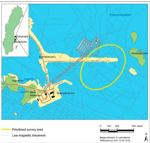
Figure 1:Map of the Forsmark-SFR area showing the location of the existing SFR and the area that was prioritized for an extension of this facility. From Figure 1-1 of SKB-R-11-10.
1.1. Relevant documentation
The documentation considered in this review begins with the top-level report that describes the site-descriptive model SDM-PSU, and the main hydrogeological background reports, which together provide an overview of the hydrogeological investigations and site-descriptive model development. Other reports considered here cover planning of the site investigations, data acquisition and interpretation,
modelling and application to SR-PSU. These are discussed in sequence in the following subsections.
1.1.1. Top-level documents
The SDM-PSU main report (SKB TR-11-04) gives a top-level description of the geoscientific site investigations, analyses, and synthesis leading to the site-descriptive model for SR-PSU.
The main sections of interest for hydrogeological review are:
Chapter 2 which describes the investigations that were carried out from the surface, tunnels within the SFR facility, and boreholes, and
Chapter 7 which describes the bedrock hydrogeology.
The latter chapter is essentially an abbreviated version of the bedrock hydrogeology report (Öhman et al., 2012, SKB R-11-03) plus a summary of the groundwater flow modelling report for the SFR site investigation (Öhman et al., 2013, SKB R-11-10). Chapters 2, 4, 5, and 6 of SKB R-11-03 correspond closely to Sections 7.1 through 7.4 of the SDM-PSU main report, but give further detail. The description of groundwater flow modelling in Section 7.5 of the main report is a very condensed summary of SKB-11-10. The discussion of confidence and remaining uncertainties in the main report draws on these two supporting reports, but is substantially restructured and rewritten.
Several other parts of the SDM-PSU main report are relevant for hydrogeological review, as discussed in the following paragraphs.
Evolutionary aspects of groundwater at the site are discussed Section 3.4. Characterization of the regolith is described in Section 4.1.2 (though the regolith depth & stratigraphy model used in SR-PSU is updated from SDM –PSU, making use of additional depth and stratigraphy data from probing and drilling in wetlands). Meteorology, hydrology and near-surface hydrology are discussed very briefly in SKB TR-11-04 Section 4.1.3, which refers to modelling studies by Bosson et al. (2008) and Mårtensson and Gustafsson (2010), and Mårtensson et al. (2010) that were carried out for the spent-fuel repository license application, for further information.
A brief section on coastal oceanography (SKB TR-11-04 Section 4.1.4) covers the definition of marine sub-basins, but does not discuss sea level fluctuations (e.g. due to Baltic storm events) which could potentially influence groundwater flow and solute dispersion in the shallow bedrock. A more detailed treatment of time-dependent sea levels is included in the modelling for SR-PSU (Werner et al., 2013). Hydrogeochemistry of the surface system is discussed briefly in TR-11-04 Section 4.1.5. Surface-bedrock interactions are discussed very briefly in TR-11-04, Section 4.4, referring to conceptual model development and calculations that were
conducted for SR-Site (Olofsson et al., 2007; Follin, 2008; Bosson et al., 2010; Johansson, 2008).
Geology as presented in Chapter 5 of SKB TR-11-04 is pertinent for information on the large-scale and small scale structures that pertain to the hydrogeological
conceptual model in terms of Hydraulic Conductor Domains (HCDs) and discrete-fracture network (DFN) models of the Hydraulic Rock Domain (HRD), respectively. Laboratory measurements of hydraulic normal fracture stiffness described in Section 6.2.2 of SKB TR-11-04 may be relevant for coupled stress-flow modelling.
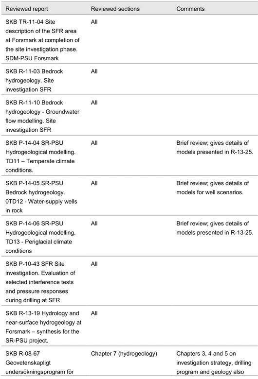
1.1.2. Site investigation planning
The main planning document considered in this review is SKB R-08-67 (SKB, 2008, in Swedish). The main chapter for hydrogeological issues is Chapter 7. The
introductory section states the goals of the hydrogeological investigations, and the central questions that these investigations were aimed to answer:
Extent and hydraulic properties of gently dipping, unloading joints and/or deformation zones within the prioritized rock volume;
Hydraulic properties of the interpreted low-magnetic lineaments; Rock mass hydraulic properties within the prioritized area and the
variability of properties depending on differences in rock type;
Scale and characteristics of hydraulic connections with the prioritized area as well as between these and the surrounding rock.
The hydrogeological investigation methods that were planned to be used in different boreholes are laid out in Section 7.3 of this report, along with brief explanations and references to SKB’s method descriptions for each of the borehole hydraulic
measurement methods used, and instructions for analysis of injection and single-hole pumping tests.
Section 9.2.3 of SKB R-08-67 gives a concise summary of previous hydrogeological data evaluations and mathematical modelling that were carried out in connection with the construction and operation of the SFR facility, and which form the basis for SDM v.0. A brief summary is also given of the main conclusions from modelling by Holmén and Stigsson (2001a, 2001b). Section 9.3.3 gives a very brief summary of plans for further development based on the hydrogeological investigation
methodology laid out by Rhén et al. (2003).
1.1.3. Model domains
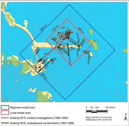
Two different model scales are used for site descriptive modelling of bedrock geology in SDM-PSU: a local scale that covers an 860 m x 720 m area immediately around the existing SFR and the proposed expanded facility, extending to 300 m below present-day mean sea level, and a regional scale that covers a 1550 m x 1685 m area surrounding the local-scale volume (Figure 2) and extending to 1100 m below sea level. Both of these volumes are stated to extend up to 100 m above present-day mean sea level. However as seen from Figure 2, only a small part of the area within the either the local area or the regional area is above sea level (a few islets of low topographic relief and several rock causeways and jetties, with a maximum elevation about 6 m above sea level).
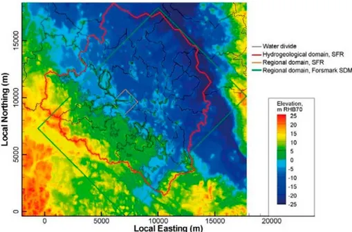
A larger hydrogeological model area was used for hydrogeological modelling for SDM-SFR, defined in terms of surface water divides (Figure 3).
Figure 2:Local and regional model areas for SDM-SFR, showing borehole coverage for different stages of investigation (according to the color key for investigations related to the existing SFR, and different shades of green for more recent stages of investigations for the SFR extension). From Figure 1-2 of SKB-R-11-10.
Figure 3:Hydrogeological domain used for SFR hydrogeological modelling (irregular area outlined in red, along surface-water divides), in relation to the regional domain for the bedrock site-descriptive modeling in SDM-SFR (orange rectangle) and the regional domain for
hydrogeological modelling in site-descriptive modelling for the proposed spent-fuel repository at Forsmark (green rectangle). The local coordinate system has its origin with respect to the national (RT) coordinate system at RT Northing = 6,692,000, RT Easting = 1,626,000. From Figure 1-3 of SKB-R-11-10.
1.1.4. Data acquisition and interpretation
The SDM bedrock hydrogeology report (Öhman et al., 2012, Table 1-4) includes a list of data that were used, with reference to specific sources whether in SKB’s Sicada database, tables in published reports, RVS or GIS models, or other specific SKB documents. More detailed account of specific datasets and their use in the analysis are given in the chapter on evaluation of primary data (Chapter 4) and in the appendices, particularly Appendices D through H which detail (D) a re-analysis of hydraulic data from the construction of the SFR, (E) analysis of hydraulic data from the extension of the SFR, (F) monitoring data of head and sea level fluctuations, (G) DFN analysis, and (H) characterisation of shallow-bedrock-aquifer structures (SBA).
Key supporting references include SKB P-04-49 (Öhman and Follin, 2010) and SKB P-10-43 (Walger et al., 2010).
Öhman and Follin (2010) give a detailed account of the interpretation of hydraulic data in terms of parameterizations for the HCDs and HRDs. The analysis is used to justify models for trends in hydraulic properties of these domains with depth, as developed further by Öhman et al. (2012).
Walger et al. (2010) give evaluations of the pressure responses in all instrumented SFR-boreholes, in response to hydraulic perturbations due to four interference tests and due to the drilling of six boreholes (one of the four interference tests, in the shallow percussion-drilled borehole HFR102, produced no identifiable responses).
1.1.5. Conceptual model and parameterization
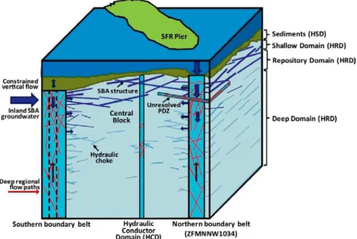
The conceptual hydrogeological model proposed by Öhman et al. (2012) is illustrated schematically in Figure 4. The main components as discussed in Section 5.5 of Öhman et al. (2012) are:
A sparsely fractured Central block described in terms of a discrete fracture network;
Hydraulic conductor domains (HCDs) of relatively fractured, transmissive rock within this block;
Southern and Northern boundary belts of relatively intensively fractured rock that provide vertical connections to the seabed and act as positive hydraulic boundaries for the fracture network in the Central block; Shallow bedrock aquifer (SBA) structures (mainly sub-horizontal)
providing lateral connects in the shallow bedrock;
Unresolved “possible deformation zones” (PDZs) which are typically subhorizontal, and are treated as part of the stochastic fracture network model;
Sediments between the seafloor and the bedrock (HSD), with vertical flow constrained both by anisotropy and convergence of flow into bedrock fractures;
Groundwater flow crossing the inland boundary of this system mainly via an inland shallow bedrock aquifer (described in SDM-Site).
The conceptualization of the discrete fracture network relies on the hypothesis that flow is compartmentalized by “hydraulic chokes” which result from
low-transmissivity connections between more well-connected portions of the network.
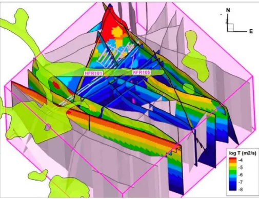
Figure 4:Schematic illustration of the conceptual model of hydraulic units, connected flowing fracture network, and flow paths toward the Central block as proposed and developed by Öhman et al. (2012). From SKB-R-11-03 Figure 5-15.
According to Öhman et al. (2012, p. 101), evidence for a compartmentalized system includes pockets of relict glacial meltwater and Littorina components, the
observation of declining flows into the SFR, apparent excess heads that could be explained by land uplift, and low hydraulic diffusivities measured in interference tests.
Hydraulic conductor domain (HCD) parameterization
The parameterization of the HCD structures is developed based on an analysis of transmissivity data for different interpreted HCDs and as a function of depth, as described in Section 5.2.3 and summarized in Section 6.2 of Öhman et al. (2012). The parameters recommended for SDM-SFR are summarized in Table 6-1 of the same report. For the 20 HCDs (out of 40 total) for which no borehole transmissivity measurements data could be assigned, transmissivities and depth trends were assumed based on pooled averages of transmissivity data for HCDs with similar strikes. For most of these, the pooled averages were based just on the newer data from site investigations for the proposed SFR extension, excluding older data (which tended to give higher transmissivities but which were questioned in terms of data quality and geological uncertainties according to Öhman et al., 2012, p. 107).
Hydraulic rock domain (HRD) parameterization
The parameterization of the HRD is based on a discrete-fracture network (DFN) description for three different depth domains:
Shallow domain (0 to -60 m RHB 70);
Repository domain (-60 m to-200 m RHB 70) and Deep domain (below -200 m RHB 70).
Öhman et al. (2012, p. 109) note that the boundary between the repository and deep domains “may be re-considered once the depth of the SFR extension has been decided.” Statistical models for these three domains are presented in tabular form (Öhman et al., 2012, Table 6-2). Two alternative size models are developed, one based on a connectivity analysis and the other on a tectonic continuum assumption.
Deterministic shallow bedrock aquifer (SBA) structures
Six subhorizontal structures, SBA1 to SBA 6 are defined by Öhman et al. (2012) based on hydrogeological data, and a seventh, SBA7, is defined as a possible subhorizontal stress relief structure based on two earlier interpreted horizontal zones (H1 and H3 in the older nomenclature), as shown in Figure 5. An eighth structure referred to as SBA8 is judged to be highly uncertain, although this structure was associated with borehole transmissivities in excess of 10-5 m2/s and required high
quantities of grouting.
Öhman et al. (2012, p. 112) regard each of these structures as likely consisting of a network of connected subhorizontal fractures, rather than a single fracture. They also note that the extensions of these structures outside of the area characterized by borehole intercepts are unknown.
Figure 5:Deterministically modelled shallow bedrock aquifer (SBA) structures (a) top view and (b) side view from the southwest. The structures are coloured by transmissivity according to the scale, as interpreted from the transmissivities at borehole intercepts. The intercepting boreholes are also shown. From SKB-R-11-03 Figure 6-3.
1.1.6. Numerical modelling
A very brief description of groundwater flow modelling for SDM-PSU is given in Section 7.5 of the main report. The main presentation is given in SKB-R-11-10 (Öhman et al, 2013). Additional hydrogeological modelling was carried out, based on an updated model for surface hydrology and the SDM-PSU bedrock
hydrogeology model. These models have been addressed in the companion review (Geier, 2015) and the descriptions are recounted in the paragraphs that follow.
Hydrogeological modelling within SDM-PSU
The main presentation of hydrogeological modelling within SDM-PSU is given in SKB-R-11-10 (Öhman et al, 2013). This report recounts the parameterization of hydraulic domains that is described in further detail by Öhman and Follin (2010), and then proceeds with two sets of model exercises:
Calculations using an equivalent continuum porous medium (ECPM) representation to test the constraining power of borehole data and the effect of different conceptual assumptions on tunnel inflows; and
Calculations using a discrete-feature representation to simulate the transient response of the interpreted network of HCDs to a series of
pumping/interference tests in boreholes.
The ECPM model exercises (described mainly in Chapter 5 of SKB R-11-10) make use of the DarcyTools code (Svensson and Ferry, 2010; Svensson et al., 2010). The
discrete-feature model exercises (described mainly in Chapter 5 of SKB R-11-10) make use of the FracMan code (Dershowitz et al., 1998).
The ECPM model exercises using DarcyTools are structured as a series of
calculations with increasing model complexity as summarized in Table 5-1 of SKB-R-11-10, starting with a simple homogeneous model of the bedrock (using the uniform, isotropic hydraulic conductivity for the HRD), then considering different degrees of horizontal vs. vertical anisotropy in combination with an HSD.
The HCD structures are then added to the model, initially using calculated properties without conditioning, but then conditioning on values of transmissivity measured at borehole and tunnel intercepts, and imposing a reduced-transmissivity “tunnel skin” around the intersections of HCD structures with tunnels. Two different variants of this model are tested in combination with deterministic SBA structures. A variety of refinements involving connectivity of two specific zones, a depth trend in the HRD, and a supposed “choking” effect of the sediment-fracture interface as well as global moderate anisotropy are also tested. After further adjustments (referred to as “optimization”) finally the resulting model is tested in combination with additional, stochastic SBA in the areas outside of borehole coverage.
In Chapter 7 of SKB R-11-10, a different variant of the model, also implemented in DarcyTools and incorporating equivalent continuum porous medium (ECPM) properties for the HRD based on a single realization of a DFN representation, is used to calculate and visualize flow paths for two different flow situations:
Inflow to the existing SFR (with nominally radial flow to the open repository)
Topographically driven flow through a hypothetically closed situation for the existing repository.
The results of the latter are used to identify discharge areas for water passing through the existing repository layout.
Discrete-feature model calculations, described in Chapter 6 of SKB R-11-10, are carried out using the FracMan code (Dershowitz et al., 1998) to simulate the transient response of the interpreted network of HCDs to a series of
pumping/interference tests in boreholes. The model setup for these calculations does not include the HRD, but just the main HCDs. The calculations are used to compare the interpreted parameterization of the HCDs with the observed hydraulic responses, constrained to propagate via the network of HCDs.
The HCDs are modelled as discrete, quasi-planar structures that are hydraulically connected only via their intersections (Figure 6). SBA structures are also included (Figure 7), and a band of reduced transmissivity at the top of each HCD is used to represent the effect of the HSD in restricting flow from the seafloor.
Figure 6:Deformation zones included in the discrete-feature model setup for simulation of interference tests, coloured by transmissivity. Excluded deformation zones are shown in gray. Boreholes where interference tests were performed are shown as pink cylinders. The ground surface is shown in pale green. From Figure 6-13 of SKB-R-11-10.
Figure 7:Sub-horizontal structures (SBA1-SBA7 and KFR_088) included in the discrete-feature model setup for simulation of interference tests, coloured by transmissivity. Deformation zones are shown in gray. Boreholes where interference tests were performed are shown as pink cylinders. The ground surface is shown in transparent brown. From Figure 6-14 of SKB-R-11-10.
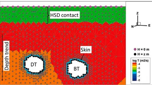
Within each structure representing an HCD, a zone of reduced transmissivity is used to represent the hypothesized skin effect around tunnels. Another zone of reduced transmissivity is used at the top of each HCD, to represent the hypothesis of a constrained contact between the HSD and the HCD (Figure 8).
Figure 8:Example of numerical model setup for part of a deformation zone (ZFMWNW0001), illustrating how the hypothesized skin effect around tunnels and constrained contact between the HSD and HCD are represented by zones of reduced transmissivity (as indicated by the color scale). The finite-element mesh is composed of linear triangular elements, with internal nodes indicated by blue dots. The upper boundary condition of prescribed head H = 0 at the seafloor is indicated by the magenta dots. The prescribed atmospheric head at the tunnel walls (H = z, note that z is negative) is indicated by the black dots on the perimeter of the tunnels. From Figure 6-15 of SKB-R-11-10.
Storativity values are assigned based on an empirical relationship to transmissivity: 𝑆𝑆 𝑆 𝑆𝑆𝑆𝑆𝑆7 √𝑇𝑇
as suggested by Rhén et al. (1997), where T is in units of m2/s (R-11-10, p. 68).
Simulated transient responses for interference tests with pumping in HFR101 and KFR105, are presented graphically and compared in terms of measured response time and peak drawdown values.
Surface hydrology and shallow hydrogeology
R-13-19 (Werner et al. 2013) provides modelling results and descriptions of present and future hydrological and near-surface hydrogeological conditions at Forsmark. The modelling is performed using the MIKE SHE software, as for the equivalent modelling in SR-Site. Results are presented for both present-day temperate and future permafrost/periglacial conditions in terms of water balance, vertical hydraulic head differences between the regolith and the bedrock, depth to the groundwater table, depth of overland water and stream discharge, residence times and inter-basin water exchanges of marine basins. The results for different discharge locations are related to biosphere objects.
Chapter 6 of SKB R-13-19 considers water resources management and exploitation by future inhabitants of the Forsmark area, considering the potential water supplies and capture zones of potential wells, including wells in bedrock. Particle tracking making use of the DarcyTools code is used to investigate the potential for flow to a well to draw in contaminated water for an exposed group farming or growing vegetables in the area. Probability of intrusion of a well is also considered. Thus this
report deals with human intrusion issues as well as predictions for the main scenarios.
Far-field hydrogeological modelling for SR-PSU
The hydrogeological modelling for SR-PSU is described by Odén et al (2014; SKB TR-13-25), as a top-level report. Further details of the calculations are given in three progress reports: SKB P-14-04, P-14-05, and P-14-06, as described in the following paragraphs (note these have also been discussed in the companion review by Geier, 2015 and the same summaries are given here).
SKB P-14-04 (Öhman et al., 2014) covers the main hydrogeological calculations for the temperate periods. It assesses of the combined effects of bedrock heterogeneity, parameterisation uncertainty, and transient flow regime in terms of performance measures. A sensitivity analysis is carried out based considering 17 “Bedrock” cases (different hydraulic parameterisations of the bedrock) in combination with six selected stages of shoreline retreat. The main results are in terms of quantitative performance measures for SR-PSU:
Disposal-room cross flow, Q (m3/s),
Coordinates of particle exit locations at the bedrock/regolith interface, Flow-related transport resistance along bedrock flow paths, Fr (y/m), and
Advective travel times along bedrock flow paths, tw,r (y).
SKB P-14-05 (Öhman and Vidstrand, 2014) focuses on interactions between the SFR facilities and potential future water-supply wells in the area. Water-supply wells are considered both for settlements associated with areas that are predicted to have arable land after shoreline retreat according to Werner et al. (2013), and for the “well-interaction area” which has the highest concentrations of radionuclides originating from the repository based on particle-tracking results for the temperate period. The analyses consider both the effect of the wells on flows through the waste vaults in the SFR, and the fraction of well discharge that is drawn from the
repository. Wells in the future arable areas are indicated to have very little interaction with flows through the repository. The results for wells in the “well-interaction area” are used in the assessment of the downstream wells scenario. SKB P-14-06 (Vidstrand et al., 2014) describes hydrogeological calculations for future periglacial periods. The model uses the same bedrock model as for the temperate case, but with thermally/hydraulically coupled solutions for flow and heat transport. Similar to the temperate model, the main results are in terms of
quantitative performance measures for SR-PSU:
Disposal-room through-flows (total and local values),
Exit locations for particle traces passing through repository vaults an through the bedrock to the bedrock/regolith interface, and
Darcy fluxes, flow-related transport resistance, path lengths and travel times along bedrock flow paths
The pressure field in the field of the SFR is also calculated as input to the near-field flow modelling. Permafrost is studied by means of two variants: One in which the frozen ground reaches elevations just above SFR 1, and one in which frozen
ground reaches elevations between SFR 1 and the SFR 3. Results are delivered for combinations of three different bedrock cases, three different permafrost depths, and three different landscape variants.
1.1.7. Application to SR-PSU
The application of the SDM-PSU bedrock hydrogeological model in SR-PSU has two major aspects:
Demonstration of site understanding
Quantitative use of modelling results to support safety assessment calculations of radionuclide transport, dose, and risk.
The quantitative links to safety assessment are summarized in in SKB TR-14-09, which is treated in Section 1.2.6 of the companion review (Geier, 2015). The demonstration of site understanding is mainly expressed in terms of the integrated conceptual model with links to hydrogeochemical interpretations, as given in Section 9.7.2 of the SDM-PSU main report. Measured inflows to the existing SFR are also presented but are subject to uncertainties in interpretation as discussed in Section 9.7.3 of the same report.
1.2. Safety relevance of review area
A detailed discussion of the safety relevance of the hydrogeological and surface hydrological issues is given in a separate review (Geier, 2015). A brief synopsis is given here.
The SR-PSU main report (SKB, 2014a) provides a basis for assessing the safety relevance of hydrogeological analysis, presenting a main scenario which is treated as the central case for the evaluating safety, and by comparing the results of the following hydrogeology-related scenarios with the main scenario:
High flow in bedrock,
Wells downstream of the repository (Section 7.6.7), Intrusion wells (Section 7.6.8),
In addition the following scenarios consider situations where flows through one or more of the vaults can be enhanced by events or processes that lead to omission, breach or degradation of the engineered barriers:
Accelerated concrete degradation (Section 7.6.3),
Combination of accelerated concrete degradation with high flow in bedrock (Section 7.8),
Bentonite degradation (Section 7.6.4), Earthquake (Section 7.6.5),
Loss of barrier function – high water flow in repository (Section 7.7.3), Unclosed repository (Section 7.7.6),
Future human actions (Section 7.7.7)
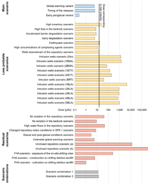
Figure 9 provides an overview of the relative consequences of these and other scenarios considered in SR-PSU, in terms of the peak annual effective dose.
Hydrogeological aspects of these scenarios, and their impacts on safety according to SKB’s evaluation, are summarized very briefly in the subsections that follow. In addition to these direct ways in which the hydrogeological site-descriptive model and associated uncertainties factor into the risk assessment, another important outcome is in terms of site understanding. Site understanding as reflected in the site-descriptive model does not factor directly into the assessment of risk in SR-PSU, but is important for the credibility of the results and assessment of uncertainty.
Figure 9:Comparative consequences of the various scenarios modelled in SR-PSU, in terms of the peak annual effective dose (from SKB 2014a, Figure 9-48).
1.2.1. High flow in bedrock
This scenario (Main report, Section 7.6.2) uses hydrogeological data from a bedrock realization (bedrock case 11) that gives high flows relative to the realization
(bedrock case 1) that was used for calculations in the main scenario. The outcome (Main report, Section 9.3.2) indicates that it produces a modest, but significant
increase in dose especially in the time interval from 3000 to 20,000 AD (Main Report, Figure 9-17). The calculated doses are not sufficient to exceed the risk criterion, but they approach within about a factor of two.
1.2.2. Wells downstream of the repository
The downstream-wells scenario considers the possibility that future human inhabitants could drill wells downstream of the repository after the Baltic shoreline retreats beyond the repository footprint, and that these future inhabitants would then utilize water from these wells for domestic purposes. The assumptions of the scenario are explained in Section 7.6.7 of the Main report.
The results for this scenario are presented in Section 9.3.7 of the main report. For one category of exposed group (a garden plot household), the total dose comes close to this risk-equivalent dose from around 3500 AD to 5000 AD, at which point the risk criterion is briefly exceeded. For other types of exposed groups the dose remains well under the level that corresponds to the risk criterion.
According to the calculation of annual risk in Section 10.3.2, this scenario when added to the main scenario gives the highest maximum annual risk of any of the “less probable” scenarios.
1.2.3. Intrusion wells
The intrusion wells scenario is described in Section 7.6.8 of the Main Report. This considers the possibility of a well for drinking water supply being drilled directly into the repository, sometime after the Baltic shoreline has retreated beyond the repository (3000 AD). The probability of such a well penetrating a given vault is estimated based on the current density of wells in the Forsmark area that reach the depth of the given waste vault.
The results as given in Section 9.3.8 of the Main Report show that for a garden-plot household, the annual dose resulting from using drinking water from such a well would exceed the dose corresponding to the risk criterion, for any of the vaults in the early period after 3000 AD, and for most vaults at least until 8000 AD.
1.2.4. Engineered barrier-related scenarios
Several scenarios consider different initial states, rates of degradation, and/or failure of particular engineered barriers, relative to the main scenario. These include accelerated degradation of concrete barriers, degradation of bentonite by formation of an ice lens in the silo during periglacial periods, and a future earthquake sufficiently strong to cause failure of the concrete barriers in the silo. The “high water flows in repository” scenario assumes that all concrete and bentonite in the waste vaults and plugs have a hydraulic conductivity of 10-3 m/s, which is very high
relative to the expected properties. The case of an unclosed repository is also considered as an extreme case in which the repository is abandoned after most or all of the inventory is in place, without installing the engineered barriers that would be installed as part of the closure process.
The accelerated concrete degradation scenario (Main report, Section 9.3.3) produces up a 50% increase in annual dose relative to the main (global warming) scenario.
The calculated doses are not sufficient to exceed the risk criterion, but they approach within a factor of two. When this scenario is combined with high flow in bedrock is described (Main Report, Section 9.5.1). The peak annual dose approaches but is still below the dose corresponding to the risk criterion. The effects of the bentonite degradation scenario (Main Report, Section 9.3.4) are comparatively minor; the main influence is seen in terms of slightly increased doses beyond 20,000 AD. A more extensive loss of barrier function in these barriers (as represented by the high water flow in repository scenario), the maximum dose increases by an order of magnitude, and exceeds the risk criterion. The scenario of an unclosed repository results in peak doses are 3 to 4 orders of magnitude above the risk criterion, depending on the assumed inventory at the time of abandonment. Together these scenarios show the importance of the engineered barriers for long-term safety of the repository.
The hydrogeological consequences of the earthquake scenario are based on an assumption that the concrete barriers in the silo fail, so water flow increases. The peak dose for this scenario is about three times as high as for the main (global warming) scenario, sufficient to exceed the dose corresponding to the risk criterion.
1.2.5. Future human actions
Scenarios involving future human actions are discussed in Section 7.7.7 of the Main Report. Actions discussed include:
Drilling into the repository,
Water management (removal or modifications to the SFR pier), Underground construction (tunnel or mine near repository),
Only the first of these is addressed quantitatively; the treatment focuses on exposure of a drilling crew or future activities on a drilling detritus landfill, which does not have a close relationship to hydrological issues. The other two categories of actions are said to be addressed qualitatively in the FHA Report (SKB TR-14-08), which has not been reviewed for this task. The qualitative discussion likely hinges on the hydrogeological modelling that was conducted for other purposes, including for the site descriptive model.
2. Assessment of SKB’s presentation
2.1. Overall quality of documentation
2.1.1. Structure and transparency
The main SDM-PSU report, the bedrock hydrogeology report (SKB R-11-03) and the hydrogeological and surface hydrological modelling reports (SKB R-11-10 and SKB R-13-25) are generally well structured and are reasonably transparent. Assumptions and methods are generally well explained, particularly in explaining what combinations of variants were considered, and how these are defined. The tables of terminology and acronyms (for example Table 1-3 of SKB TR-11-03 and Table 1-4 of SKB TR-11-10) are especially helpful.
One weakness discussed further in the companion review (Geier, 2015) is that the main numerical model used for the deep hydrogeological system, DarcyTools, is explained only briefly as a series of equations solved, for example in Appendix A of SKB TR-13-25), and a very general summary in the Models summary report. The description of bedrock hydrogeological modelling by Öhman et al. (2013) is detailed and thorough in terms of describing the different steps of modelling and the reasons for testing different variants. This report seems to have been less thoroughly edited for technical English than most of the other reports considered in this review, as it contains some unusual expressions (for example on p. 40 there is a discussion of the “hydraulic dignity” of SBA structures relative to the sheet joints encountered at Forsmark; presumably some other term such as “hydraulic rank” or “hydraulic order” was intended). However the technical assumptions, logical approach, and intended meanings are generally clear from the presentation.
2.1.2. Traceability
The SDM bedrock hydrogeology report (Öhman et al., 2012, Table 1-4) includes a list of data that were used, with reference to specific sources whether in SKB’s Sicada database, tables in published reports, RVS or GIS models, or other specific SKB documents. The background reports describing analysis of interference tests (SKB P-10-43) and parameterization of the HCDs (SKB P-09-49) also give a clear account of the data used and the different steps and assumptions in the analysis. Extensive appendices in both R-11-03 and R-11-10 document the details of analysis, submodels, model variants, and key datasets. These appendices appear to be
sufficiently detailed to support more detailed reviews on most of the key topics. Links to analyses that are documented in the background (P-series) reports are also generally clear.
As one example, a more intensive review of SKB’s use and interpretation of cross-hole responses to interference tests (in both “old” and “new” SFR datasets) could be
well supported by information given in Appendices D and E of SKB R-11-03, Chapter 7 of SKB R-11-10, and the background report by Walger et al. (2010). One area that is less traceable is the handling of uncertainties. The uncertainties identified by (Öhman et al., 2012) do not clearly map into the discussion of
confidence and remaining uncertainties in Section 7.6 of the SDM-PSU main report. This is discussed further in Section 2.3.
2.1.3. Scientific soundness
The scientific approach employed in developing the bedrock hydrogeology portion of the site descriptive model is generally credible, in terms of the methods of analysis employed and the inferences drawn. However the descriptive model presented as the outcome is not mature to the level that should be expected for a safety assessment in support of a license application. Strengths and weaknesses of the scientific and technical development can be assessed in terms of the following major topics:
Structural geological basis for hydrogeological models Analysis of hydraulic interference tests
Analysis of trends and heterogeneity in hydraulic domains Treatment of bedrock fractures outside of deformation zones Understanding of processes limiting inflows to tunnels
Consequences of inflow uncertainties for repository resaturation Hypothesis of hydraulic choking at sediment-fracture interface Overall maturity of site interpretation
These topics are discussed sequentially under the corresponding headings.
Structural geological basis for hydrogeological models
The structural geological interpretation as presented in Chapter 5 of SKB TR-11-04 guides the identification and classification of the large-scale and small scale structures that are the basis for the hydrogeological conceptual model in terms of HCDs and DFN models of the HRD, respectively. Much of the information is drawn from the structural geological model for SR-Site, but with more detailed attention to the areas that are currently offshore. Notable differences in terms of data support are the lack of outcrops at ground surface, but the availability of underground mapping data from the lower construction tunnel (NBT) in the SFR. As for SDM-Site, borehole logging with BIPS plays a major role in constraining the geometric properties of the DFN models.
Fractures that were mapped in the tunnel for SFR construction have been considered but their quantitative treatment is limited. According to TR-11-04 (p. 71-72), many of these are below the scale that is considered for deterministic modelling in the SDM, and some of the minor structures in the drawings of Christiansson and Bolvede (1987) do not meet current criteria as “possible deformation zones.” However the report states that all of the features in the structural drawings of Christiansson and Bolvede (1987) have been treated as “possible tunnel deformation zones (tPDZs). The treatment of these older data should be considered as part of a
more detailed review of the completeness of SKB’s use of relevant data to address uncertainties in the hydrogeological model.
Analysis of hydraulic interference tests
Walger et al. (2010) give evaluations of the pressure responses in all instrumented SFR-boreholes, in response to hydraulic perturbations due to four interference tests and due to the drilling of six boreholes (one of the four interference tests, in the shallow percussion-drilled borehole HFR102, produced no identifiable responses). The presentation is systematic and based on generally accepted principles of well-test analysis. Diagnostic plots and response matrices are included that are consistent with current scientific practices and give a sufficient basis for independent
evaluation of the results.
The approaches to interpretation of these tests by Walger et al., (2010), as well as subsequent modelling of the propagation of pressure disturbance in a HCD network model by Öhman et al. (2013), appear to be technically sound and scientifically credible. However due to the significance for understanding hydraulic connections at the site, it is recommended that these data and interpretations be considered within a detailed-phase review of the hydrogeologic data and their application to
parametrization of the hydraulic domains as discussed under the next heading.
Analysis of trends and heterogeneity in hydraulic domains
The analysis to support the concept of depth-dependent trends in the HCDs and HRD is described in detail by Öhman and Follin (2010, SKB P-10-43). This gives a detailed account of the interpretation of hydraulic data in terms of parameterizations for the HCDs and HRDs. The analysis is used to justify models for trends in hydraulic properties of these domains with depth.
The account is thorough and sufficient to support an external review of the details. The conclusions regarding trends are arguable but the analysis is transparent. Sensitivity to the classification of data as belonging to HCDs vs. HRDs is included. The focus has been in terms of vertical trends, but a full consideration of possible lateral trends is lacking. Plots are presented of HCD variability in transmissivity with depth, but not along strike. For the HRD, a trend in depth is suggested but analysis of lateral trends is limited, particularly for the rock north of the SFR where data are very limited. Use of older data and data from partly-penetrating intervals appears to have been limited and non-systematic based on the discussion in Öhman et al. (2013).
The possibility of lateral trends in the HRDs is very briefly discussed and dismissed despite an apparent trend of increasing PFL-f transmissivities from the Central block toward the Northern boundary belt. The rationale given by Öhman et al., 2012 (pp. 109 and 114) is that confidence in the apparent trend is limited due to “borehole coverage gaps, sampling bias, and variable detection limits” in combination with the lack of packer test (PSS) data to assess the role of hydraulic chokes.
Öhman et al., 2012 (p. 107) mention both uncertain data quality and geometric uncertainties as a justification for excluding older data from evaluation of HCDs properties. The older data tended to indicate higher transmissivities for these HCDs. To the extent that this is a function of geometric uncertainties (presumably meaning
that elevated transmissivities belonging to some intervals outside of a given HCD, for the current model, were assigned to that HCD in the earlier interpretation), this implies that the higher transmissivities should need to be taken up by the model for the HRD. This has not been done, as these older data were simply excluded. A review is suggested of the uncertainties identified by Öhman et al. (2012, 2013), as well as independent interpretations of the underlying transmissivity data and trends. The datasets listing transmissivity values in all boreholes (both “old” and “new” datasets), and transient records of responses during interference tests, should be requested to support this type of analysis.
A more thorough review of the HCD and HRD parameterization is therefore suggested. This review should also consider whether all of the available data have been used as fully and effectively as is reasonably feasible to constrain the parametrization, or whether some of the older, lower-resolution data could provide further significant constraints on the model.
Treatment of bedrock fractures outside of deformation zones
Analysis of data to support an updated hydrogeological DFN model is presented mainly as an appendix (Appendix G) of Öhman et al. (2012). The methodology is similar to that employed for derivation of the corresponding models for SR-Site, but with less consideration of alternatives for fracture spatial models and the inferred relationship between fracture transmissivity T and fracture size (expressed as fracture effective radius r). Only a Poisson process for fracture location has been considered. Two different assumptions are tested for scaling of fracture size and intensity, but only one relationship between T and r has been evaluated, namely a perfect correlation of transmissivity to fracture size, T = arb. This contrasts with
SR-Site where three different relationships between T and r were evaluated, and a fractal model for fracture location was tested.
Analysis of variation in fracture properties with depth has led to definition of three different depth zones in the DFN model. A corresponding analysis of spatial variation in the lateral direction is minimal (in part due to limited data support from north of the SFR), with just a brief consideration of differences between the two rock domains RFR01 and RFR02 (Öhman et al., 2012, p. 271-272). Details to support the conclusion of negligible difference between rock domains are not presented. The authors argue that it is difficult to ascertain differences due to “heterogeneity, data gaps, and sampling bias.”
The model for outside of the SFR regional domain comes from SDM-Site. There is practically no information from the northern boundary belt to support use of this model there.
Öhman et al. 2013 (p.37) present results for only one realization of the inferred DFN model for the HRD portion of the bedrock. Thus even within the framework of the derived DFN model, stochastic uncertainties have not been explored.
Sheet joints in the shallow bedrock have been treated both deterministically and with a stochastic model of the “shallow bedrock aquifer” (SBA) by Öhman et al. (2013, model case M7). The methods for developing the stochastic SBA model are acknowledged by Öhman et al. (2012) to be non-systematic in comparison with other stochastic fracture models developed by SKB in SDM-Site and SDM-PSU.
Thus it can only be regarded as illustrative rather than a quantitatively justified model. Only two realizations of this model are considered, so furthermore the illustrative application has been limited.
Further review of the DFN and SBA models, focusing on the potential significance for the safety case of unevaluated uncertainties, is therefore suggested.
Understanding of processes limiting inflows to tunnels
A key unresolved issue for site understanding is the reason for continuing decline in flow to the existing SFR vaults and tunnels, over time. Five possible mechanisms are suggested as explanations on p. 47 of SKB R-11-03:
Heterogeneity and isolated/compartmentalized rock mass; Unsaturated fracture flow (possibly including degassing effects); Particle clogging due to transport of particles from seafloor sediments or
existing fracture fillings;
Fracture sealing due to chemical precipitation and microbial growth; Hydromechanical closure of fracture due to increasing effective normal
stress as groundwater pressures drop in fractures close to the excavation. However very little evidence is presented as to their quantitative impact, apart from a simple scoping calculation for hydro-mechanical closure due to drainage of a horizontal fracture.
Considering that the trend in inflow measurements has been generally downward with a fairly consistent trend over nearly three decades since SFR was constructed the late 1980s, it is worrisome that SKB does not have a more clear quantitative justification.
No data are presented to quantify the inferred “skin effect” that was used as a model calibration parameter by Holmén and Stigsson (2001), such as (for example) head measurements in probe holes drilled out from the walls of the underground tunnels. This seems to be a key unaddressed aspect of site understanding that SKB should have tried to investigate, at some point in the past 15 years if not sooner.
Consequences of inflow uncertainties for repository resaturation
An understanding of the reasons for the decline in flows, and the calibrated “skin effect,” is important both for confidence in post-closure flows through the waste vaults, and evaluations of the duration and importance of the resaturation period after closure. The model calculations by Holmén and Stigsson (2001) are referred to in several of the supporting documents for SR-PSU (see companion review by Geier, 2015) as the basis for assuming that the resaturation period is sufficiently brief that an analysis of resaturation processes is unnecessary.
As noted by Öhman et al 2013 (p. 35), the Holmen and Stigsson (2001) model was based on a different structural model with fewer structures, and calibrated to 1997 inflow data which were 64% higher than the 2010 data used in SDM-PSU. As complementary information, SKB should explain the impact of using this old model, as the basis for quantitative estimates of the resaturation period duration and as justification for omitting a more detailed analysis of the resaturation period.
Hypothesis of hydraulic choking at sediment-fracture interface
Öhman et al (2012, Section 4.7.1) propose a concept of “hydraulic choking” at fracture-sediment contacts, which is invoked to explain part of the apparent resistance to flow through seabed sediments into discrete fractures. The proposed “choking” effect is supposed to represent the resistance that results from
convergence of flow from a porous continuum into sparse, discrete fractures that are highly transmissive but have small apertures. Scoping calculations of the effect are carried and used to justify a “skin factor” at the interface between HRD and HSD. From a geological perspective, this conceptual model and its numerical
implementation are based on an overly idealized view of discrete fractures,
particularly highly transmissive fractures that reach the upper surface of the bedrock. Noting that the geological rate of erosion of the bedrock surface is very slow, such fractures have been exposed to many climate cycles in their current configuration, and hence tend to have a complex structure widening toward the bedrock surface, due to the effects of weathering, freeze-thaw cycles, and glacial plucking or scouring of rock fragments. Hence the convergence in the overlying sediments need not be so extreme, as there may be a funnelling effect in the complex, surficial portion of fractures.
Furthermore anisotropy of the sediments, with higher hydraulic conductivity in the horizontal direction, can be expected for shallow Baltic sediments in a relatively sheltered bay such as over the Forsmark site. The authors do acknowledge (on p. 80) that such a situation would reduce the “choking” effect, but the scoping calculations that they present are based on an isotropic model of the sediments.
This is likely not a major issue affecting the safety relevance. However its
introduction as a justification for skin effects at the Quaternary-bedrock contact adds to the impression that the hydrogeological analysis for SDM-PSU is still at an exploratory stage, rather than representing a fully mature stage of descriptive modelling.
Overall maturity of site interpretation
The modelling study by Öhman et al. (2013) is well-explained as a step-by-step process of investigation, but the selection of model variants is ad hoc rather than systematic. The discussion of alternative interpretations seems more appropriate for an initial stage of SDM development rather than an exploration of the properties of the final bedrock hydrogeological interpretation for SDM-PSU. The conclusions of this study as presented in Chapter 8 of Öhman et al. (2013) discuss the different variants in terms of their ability to improve certain aspects of the model, but do not point to a clear “central” model parameterisation that is considered most likely to represent the important properties of the site for safety.
The main bedrock hydrogeology report (Öhman et al., 2012, SKB R-11-03) was published before the modelling report (Öhman et al., 2013), and references to the latter are limited. The conclusions of the main report are in the form of a qualitative discussion that mentions different alternatives, but does not go any further than the modelling report, in drawing together a clear statement of a “central” model. In several places, the main bedrock hydrogeology report (Öhman et al., 2012) cites the lack of hydraulic packer-test (PSS) data to complement PFL-f measurements as a key factor limiting the understanding of the HRD. This apparent deficiency could
have been remedied by a follow-up program of testing and analysis, but this was not done. The higher-level reports do not clarify whether this apparent deficiency identified in the analysis by SKB’s consultants was dismissed based on scientific arguments, or simply ignored due to project schedule/budget constraints.
The weakness of the tunnel inflow data for discriminating among these variants is acknowledged by Öhman et al (2013). Heads in monitoring wells are also compared but without drawing clear conclusions. Systematic methods for optimizing the parameterization (such as response surface methods) in terms of its ability to reproduce the observations have not been employed.
Taken together, the reports on descriptive model development for bedrock hydrogeology reflect a very substantial amount of work to explore different possibilities, but which stopped short of producing an integrated model that weaves together the different threads of exploration.
The decision to proceed from this situation to modelling for a license application implies a need for SKB to provide a comprehensive assessment of unresolved hydrogeological model uncertainties, in support of SR-PSU.
2.2. Important data and assumptions
The most important data and assumptions that propagate from the hydrogeological analysis into the SR-PSU safety analysis are those that affect the estimation of groundwater flux through the vaults, and secondarily transport properties along discharge paths.
In the models presented by SKB within SDM-SFR, the key aspects affecting groundwater flux are:
HCDs and their parameterisation;
Effect of HSD layer, particularly seabed sediments and hypothesized “skin effects” at the HSD-HRD interface, for limiting fluxes at depth;
SBA properties and their influence on limiting hydraulic head gradients at repository depth;
HRD properties as represented by the stochastic DFN model; and Hypothesized tunnel skin effects and their persistence in the post-closure
period.
Concerning the first of these, the HCDs have been a major focus of SKB’s analysis. The details of this analysis are adequately presented to support detailed review. The effects of the HSD layer and seabed HSD-HRD interface are likely most significant during the open repository period, and will become less important following closure and coastline retreat, when terrestrial processes are likely to reduce the resistance to vertical flow (either by erosion of the HSD or by
bioturbation processes that increase vertical permeability), and regional flow driven by topography becomes more important. However assumptions regarding the HSD affect calibration of the bedrock hydrogeological model.
The SBA has been represented both by a set of 8 deterministic features and by a stochastic representation. Substantial uncertainty is associated with the role and
extent of these features. However the model exercises presented by Öhman et al. (2013) provide a reasonably adequate basis for interpreting the potential impacts of these structures on repository fluxes.
The roles of the HRD properties and associated uncertainties are not fully clear from the analyses that have been presented, in part because of SKB’s limited evaluation of conceptual and stochastic uncertainties associated with this domain. The residual flowrates into the SFR, following grouting of intersections between tunnels and the main HCDs, indicate that the role of the HRD is significant. However it could diminish after closure if HCDs become more dominant as grout degrades. The skin effect attributed to open tunnels in the SFR could be regarded as an issue that mainly just affects model calibration, if the hypothesized explanations are correct and these effects are reversed following saturation. However even if this interpretation is correct, the persistence of the skin effect following closure could impact the duration of the resaturation period.
Conceptual uncertainty in the physical explanation for tunnel skin effects is high. This translates into substantial uncertainty in resaturation processes, which have mainly been discussed but not analysed by SKB.
2.3. Handling of uncertainties
The “hydrogeological” key issues identified by Öhman et al. (2012, Section 7.6) include most of the main uncertainties that are likely to be significant for
groundwater flux and flow path properties affecting safety assessment calculations. Uncertainty in HCDs and their parameterisation has been the subject of considerable attention in SKB’s hydrogeological site-descriptive modelling. Several different alternative parameterizations involving depth dependency and heterogeneity have been evaluated in the modeling exercises, giving a reasonable basis for assessing the sensitivity insofar as these were propagated to safety assessment.
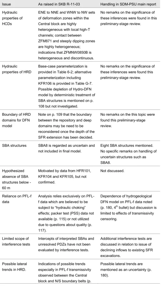
Uncertainties in the HRD and SBA have been considered to a more limited extent, and therefore more detailed review of these aspects of SKB’s site descriptive modelling is recommended. Öhman et al. (2012) recognize that residual uncertainties in terms of bedrock (HRD) connectivity may play a role in the apparent lack of steady-state conditions in response to excavation of the SFR. The hydrogeological uncertainties identified by (Öhman et al., 2012) do not clearly map into the discussion of confidence and remaining uncertainties in Section 7.6 of the SDM-PSU main report (Table 1). Tracking and accounting for the handling of uncertainties from different stages of model development is recommended as a topic for further review. As input to such a review, it could be useful to request SKB’s own accounting of how they have taken these uncertainties into account, as complementary information.
Table 1:Comparison of uncertainties/issues raised in bedrock hydrogeology report (SKB-11-03) versus handling in the SDM-PSU main report (SKB TR-11-04 Section 7.6).
Issue As raised in SKB R-11-03 Handling in SDM-PSU main report Hydraulic
properties of HCDs
ENE to NNE and WNW to NW sets of deformation zones within the Central block are highly heterogeneous with local high-T channels; contact between ZFM871 and steeply dipping zones are highly heterogeneous; indications that ZFMNW0850B is heterogeneous and discontinuous.
No remarks on the significance of these inferences were found in this preliminary-stage review.
Hydraulic properties of HRD
Base-case parameterization is provided in Table 6-2; alternative parameterization including KFR106 is provided in Table G-7. Possible depletion of Hydro-DFN model by deterministic treatment of SBA structures is mentioned on p. 108 but not investigated.
No remarks on the significance of these inferences were found this preliminary-stage review.
Boundary of HRD domains for DFN model
Note on p. 109 that the boundary between the repository and deep domains may be need to be reconsidered once the depth of the SFR extension has been decided.
No remarks on the this topic were found this preliminary-stage review.
SBA structures SBA8 is regarded as uncertain and not included in final model.
Eight SBA structures mentioned. No specific remarks on handling of uncertain structures such as SBA8.
Hypothesized absence of SBA structures below -60 m
Motivated by data from HFR101, KFR104 and KFR105, but not confirmed.
Not discussed.
Reliance on PFL-f data
Analysis relies exclusively on PFL-f data which are believed to be subject to “hydraulic choking” effects; packer test (PSS) data not available (p. 115) or not utilized due to questions about quality (p. 117).
Dependence of hydrogeological DFN model on PFL-f data noted (p. 180, 4th bullet) but discussion is
limited to effects of transmissivity censoring.
Limited scope of interference tests
Intercepts of interpreted SBAs and unresolved PDZs have not been evaluated by interference tests.
Additional interference tests are discussed in relation to issue of declining inflows to existing SFR excavations.
Possible lateral trends in HRD.
Indications of possible trends especially in PFL-f transmissivity observed between the Central block and N/S boundary belts (p.
Possible lateral trends are mentioned as an uncertainty (p. 180).
116). Various alternatives suggested in Section 5.6. Use of “old” data
from the existing SFR
Older data seem to result in higher transmissivities of deformation zones, but only used as
complementary data in SDM-SFR. Only core-drilled boreholes surveyed by PFL-f method used in SDM-SFR.
Historic and recent data noted to be of different quality and test types, and reflect different stages of the SFR disturbance; this complicates the use of a single model for different sub-domains. No discussion of plans for re-testing old boreholes. Time-dependent
decrease in inflow to existing SFR excavations
Alternative explanations raised but not quantified.
Acknowledged in general terms, but stated that of the possible reasons “probably all of them are reversible.” Suggested that further analysis of interference tests could shed light on this issue but due to short duration of these tests, calibration of storativity is a key issue. Longer-duration interference tests are mentioned as a way to provide more robust data but no plans to conduct such tests are indicated.
Uncertainties in SFR inflow measurements due to ventilation
Scoping calculations indicate significant impact of ventilation air.
Uncertainty acknowledged as +/- 30 liters per minute, depending on the season. No plans for
3. Suggestions for further review
Several topics for further review have been identified in the foregoing chapters of this technical note. These are summarized here in terms of related topics that could be addressed most efficiently as integrated topics for the detailed review phase.
3.1. Parametrization of hydraulic domains
The parametrizations of the HCD and HRD are key for long-term flows to the waste vaults. Key uncertainties include the validity of interpreted trends with depth, the possibility of spatial trends in other dimensions or depending on lithological or structural domains which have been less thoroughly analysed, and the character of heterogeneity not explained by spatial trends.
A more thorough review of the HCD and HRD parametrisation is therefore recommended. This review should also consider whether all of the available data have been used as fully and effectively as is reasonably feasible to constrain the parametrization, or whether some of the older, lower-resolution data could provide further significant constraints on the model.
The datasets listing transmissivity values in all boreholes (both “old” and “new” datasets), and transient records of responses during interference tests, should be requested to support this type of analysis.
3.2. Stochastic models of transmissive fractures
The site-descriptive model development for bedrock geology includes development of a quite elaborate DFN model for the hydraulic rock domain (HRD), as well as a more stylized stochastic model of highly transmissive, mainly subhorizontal fractures that are considered to be part of a shallow bedrock aquifer (SBA). The hydrogeological modelling within SDM-PSU and SR-PSU has considered only a very limited number of realizations of these models, leaving questions as to the significance of their stochastic properties. In addition, uncertainties are associated with assumptions that were introduced in deriving these models, particularly for the stochastic SBA model.
Further review of the DFN and SBA models, focusing on the potential significance for the safety case of unevaluated uncertainties including stochastic variation, is therefore suggested. The utilization of relevant hydro-structural information from the SFR construction should also be examined, as part of this assessment.
3.3. “Hydraulic chokes” in the rock mass
The concept of “hydraulic chokes” in the fracture network in the rock mass in between HCDs is raised repeatedly in the documents considered for this review. The lack of usable data from packer tests, to complement PFL-f measurements, is mentioned repeatedly as a shortcoming of the site-characterization dataset that precludes resolution of this issue.
An independent evaluation of this issue is warranted. This should address firstly whether the interpreted hydro-DFN model of the rock mass leads to “hydraulic