GEOGRAPHIC PROFILING
LOCATING THE SERIAL
MURDERERS
STAVROS MAKRIS
Master thesis in Criminology Malmö Universitet Criminology Master’s Programme (120 credits) Health and Society
GEOGRAPHIC PROFILING
LOCATING THE SERIAL
MURDERERS
STAVROS MAKRIS
Makris, Stavros. Geographic Profiling. Locating the Serial Murderers. Degree Project in Criminology 30 credits. Malmö University: Faculty of Health and Society, Department of Criminology, 2018.
Geographic profiling is a technique used by crime investigators and the police to examine the locations of a connected series of crimes, to determine the most probable area of the offender’s residence. Using both qualitative and
quantitative methods, Geographic profiling helps to better interpret the spatial behavior of an offender and focuses the investigation on a specific and smaller area of the community. From the abovementioned and from previous research, we know that Geographic profiling is useful in serial crimes such as in cases of serial murderers, serial rapists etc. Having as a point of reference Malmö, because of the many shooting incidents that have happened through the last years, in this master thesis dissertation, a systematic literature review on Geographic Profiling will be conducted while at the same time the usefulness of the method in locating the serial murderers will be examined.
Keywords: Geography of crime, profiling, location, serial crime, murderers, shootings
ACKNOWLEDGEMENTS
I would like to express my sincere thankfulness to the important people that with their support helped me to make my dream of becoming a Criminologist come true. First of all, I truly appreciate the help and the guidance I received from my supervisor Zoran Vasiljevic and all of my professors during this journey. My mentor Cecilia Sahlström for all the fruitful discussions and the inspiration. My Greek and International friends and,
last but not least my family, especially my dad and mom for all the love and the support they have shown since the day I was born.
Μπαμπά και μαμά, σας αγαπώ πολύ!
Stavros Makris Malmö, May 2018
TABLE OF CONTENTS
INTRODUCTION ... 1
The case of Malmö ... 1
Aim ... 2 Research questions ... 2 Disposition plan ... 2 BACKGROUND ... 3 Geographic profiling ... 3 THEORY ... 4 Environmental Criminology ... 4
Routine Activity Theory ... 5
Rational Choice Theory ... 6
Crime Pattern Theory ... 6
The Circle Theory of Environmental range ... 8
METHODOLOGY ... 9
Systematic literature review ... 9
Ethical aspects ...10
Flow Diagram ... 10
RESULTS ... 11
How Geographic profiling works and under what conditions? ... 13
Geographic profiling: locating the serial murderers ... 15
Factors for choosing the location of crime ... 17
DISCUSSION ... 19
Methodological considerations and limitations ... 20
Practical and future implications ... 21
CONCLUSION ...21
1
INTRODUCTION
“Malmo shooting: At least one dead and another injured after gunfire in Sweden” (Sunday Express, Nov 30, 2017). “One dead and another injured in Malmö shooting” (The Local, Dec 1, 2017). “Fear grows in Malmö despite falling crime” (Radio Sweden, Dec 4, 2017). “Police investigate fatal shootings in Malmö and Stockholm suburb” (The Local, Jan 15, 2018).
Many times, while being a student of Criminology in Malmö, I found headlines like the abovementioned, being the protagonists of the Swedish media regarding the situation with the fatal shootings. Some crucial questions on the matter are how could the police locate the offenders’ base in order to arrest the criminals and how Geographic Profiling could contribute to that? Which factors influence the serial killers to choose the location of the crime and with what tools and methods could the administration handle the issue?
Geographic profiling is the method that crime investigators and the police use to locate the offender's most likely area of residence. Geographic profiling has turned out to be one of the most powerful and flexible tools in crime
investigations. Originally developed for analyses of serial murder cases, soon it became applicable to other areas too, such as rapes, sexual assaults, arsons, robberies, bombing investigations and in the recent years in crime types like kidnaps, burglaries, thefts, frauds, and vandalism (Rossmo, 2014).
While the method of criminal profiling tries to define several
characteristics of the offender e.g. (age, sex, race or intelligence) from his or her actions in a criminal incident, the geographic profiling approaches on just one perspective of crime: the offender's most probable location (Petherick, 2014). As Rossmo (1997, p.161) supported, geographic profiling targets to the “probable spatial behavior of the offender within the context of the locations of, and the spatial relationships between, the various crime sites”. The true intention of the method is not to be an investigative panacea, but a useful tool ready to be used by the police in order to prioritize the search areas (Petherick, 2014). Moreover, geographic profiling works as a “decision support system” calculating the most probable geographic area the offender could live as well as some other locations with which the perpetrator is familiar, the so-called “activity nodes”. In other words, in geographic profiling, everything has a reason and criminal behaviors are not random, which according to the method means, that most crimes have rhyme or logic to them (Wilson, 2003). As Wilson, 2003 said, “Crimes are not just random - there’s a pattern. It has been said that criminals are not so different from shoppers or even from lions hunting a prey. When an offender has committed a number of crimes, they leave behind a fingerprint of their mental map, and you can decode certain things from that. We put every crime into a computer program and it produces a map showing the most probable areas the police should target”. The case of Malmö
Analyzing the matter in a Swedish context, it needs to be mentioned, that Sweden was considered one of the safest in western Europe’s countries
concerning the possibilities of being a victim of a serial crime. This, however, is no longer true, since the country has been affected by the increasing use of gunfire violence that most of the times can be fatal for the victims. One of the most
2 Malmö (Khoshnood, 2017).
As Harries & LeBeau, (2007) mention, in a normally low-crime
environment, serial murders or rapes, for example, stand out immediately. In a high-crime area, as in our case, in Malmö, serial crimes can be hidden among the many crime incidents. Specifically, the last years, and especially 2016, Malmö has had significant problems with gunfire violence, since many shootings happened in the area, counting 10 cases of homicides and 20 cases of attempted homicides. With a population of 300.000 inhabitants, the situation in Malmo seemed to be out of control, but it cannot be compared with the incidents happened in 2017, that within the first 13 days of the year, the situation became a nightmare, when the 3rd of January an 18year old girl was wounded after being shot (Persson P,
Persson A, Paulsson A, et al., 2017) and later the same day a young man murdered (Johansson A, Persson A., 2017). Three days later, a man also found dead after being brutally shot in his apartment while at the 12th of January, a 16-year old boy was viciously killed by gunfire wounds, with many bullets in his head and face while returning home (Runol M, Westerberg O., 2017).
However, we are not sure if the crimes that have been mentioned should be considered as serial because there is no evidence that the crimes had been committed by the same murderer, as in the case of the serial shooter Johan Peter Mangs some years before, in 2009 and 2010 in the same city, Malmö. In that case, the police had considered that many of the 2010 shootings, were committed by the organized crime. However, a serial killer was behind.
Such types of crimes are difficult to be addressed and more effective measures need to be taken by the police and the criminal investigators.
Geographic profiling targets in serial crimes and seems a promising investigative method that could shed light in such cases, when identified as serial, by trying to predict the most probable locations of the offenders’ base. And the purpose of this dissertation is exactly this. To examine the applications of the Geographic
profiling in locating the serial murderers and finally to arrest them. Aim
This master thesis dissertation sets out to present and analyze the method of geographic profiling and its’ application in locating the serial murderers. By examining all aspects of this investigative approach, this paper will try to provide to the scientific community and to anyone else interested in the geography of crime, a glimpse of the history and methods of the geographic profiling and by conducting a systematic literature review of the subject, a try to answer the following questions will be made:
Research questions
1. How Geographic profiling works and under what conditions?
2. How could the Geographic profiling be useful in order to locate serial murderers?
3. Which factors influence the serial murderers to choose the location of crime?
Disposition plan
This master’s thesis dissertation includes an introduction to the
3 with the background, the theory, the methodology, and the results of the research following to the next chapters. Finally, a discussion and the conclusion for further development of the method are being presented.
BACKGROUND
Geographic profiling
To analyze and understand the method of geographic profiling, at first, there is the substantial need to determine it. Geographic profiling is the strategic information management system created to contribute to the serial violent crime investigations. It is included in the Police behavioral science response and as a field is close to both linkage analysis and psychological profiling. As a definition has the same roots with the offender profiling method, which is an approach for the deduction of an unknown offender, based on evaluations of details of the crime scene, the victim, and other available crime data (Copson, 1995 in Rossmo, 2000).
The first geo-profiling was prepared in 1990 by the Vancouver Police department, with the authority to provide services to the international police community. Since then there are several different federal, provincial, state and local law enforcement agencies such as the Royal Canadian Mounted Police (RCMP) in Canada, the National Crime Faculty in England, the
Bundeskriminalamt (BKA) in Germany, the Bureau of Alcohol, Tobacco and Firearms (ATF) in the USA and many more, that request the use of the method to their investigations mostly in cases of serial murders, serial exposers, sexual homicides and kidnaps (ECRI, 2002). This paper will investigate the applicability of the geo-profiling method in locating the serial killers.
Geographic profiling is the tool for determining the most probable area of the offender’s base of action through an analysis of his or her crime locations (Rossmo, 2000). With the geo-profiling technology, investigators spent fewer resources, especially when there are thousands of probable suspects (Velarde, 2004). The approach focuses the investigations of the suspects while using a combination of environmental criminology theory, research on offender spatial behavior, and mathematics, which has been transformed into a promising profiling software, the so-called, “Rigel” created by the Environmental Criminology
Research Inc (Velarde, 2004).
Rigel software works by using an algorithm named as criminal geographic targeting (CGT) to visualize a geo-profile, a two-dimensional probability surface that uncovers a street map that shows the possible location of the offender’s home (Rossmo, 2013). This visualization consists of colors in the map that represent probability. While it might seem like a hot-spot map of the crimes, it is actually showing different facts, the location that the perpetrator is most likely based rather than the areas that crimes are committed (Velarde, 2004).
The reason why geographic profiling is unique is that it prioritizes suspects based on their address information (Mackay,1999). In many cases, the number of suspects can be numerous and here the role of this investigative method is crucial because it provides to police the necessary information they need to manage the cases (Rossmo, 2012).
4 With geographic profiling, the investigative strategies could be used by the inspectors are several. For instance, analysts can prioritize police records such as arrests, field interviews or jail booking sheets. These data usually include the perpetrator’s address, physical description and previous arrest charges (Rossmo, 2014). Moreover, another use of geo-profiling is for the prioritization of areas for directed police patrols or area canvasses. This method could be useful especially if the perpetrator is acting all along a narrow period. Geo-profiling is the tool that provides specific information to the local neighborhood’s residents and watch groups. It may also be useful for the placement of specific tools that collect data about people or automobiles that pass by a location, like pole cameras or license plate readers. The collected information using such tools can be reviewed and analyzed by the investigators (Police Foundation, 2016).
THEORY
In the following chapter, theories related to the method of Geographic profiling will be analyzed, including theories of the Environmental Criminology such as the Routine Activity, the Rational Choice, the Crime Pattern Theory, and the Circle Theory of environmental range.
Environmental Criminology
As Brantingham & Brantingham (1998) supported, Environmental criminology is interested in the interactions between people and what surrounds them. They consider crime as a product of probable perpetrators and their immediate and remote setting. According to that, environmental criminologists use the concept of geographic imagination together with the sociological imagination, to explain, understand and command the criminal incidents (Brantingham & Brantingham,1981c, p. 21). The research has been made by Brantinghams is differentiated from the early ecological theories of the Chicago School, by spotlighting to the criminal event this time and not to the offender. The field is broad and its thematic stem from human ecology, environmental
psychology, behavioral geography, and cognitive sciences (Rossmo, 2000).
Generally, criminological positivism has shown its interest mostly to the offenders and much research has been done concerning their backgrounds such as peer influences, criminal careers, or the effects of deterrence. However, this focus has forgotten other components of crime like the victim, the criminal law, and the crime setting. And speaking about crime setting or place, the “where and when” of the criminal incident, comprises what Brantingham and Brantingham called as the fourth dimension of crime, which is the main concern of the environmental
criminology (Jeffery, 1977).
Geographic profiling has some solid foundations behind, such as the ideas and theoretical fundamentals of the Environmental Criminology. Theories like the Routine Activity, the Rational Choice, and the Pattern Theory comprise various of the theoretical approaches the Environmental criminology has identified and are related to the method of Geographic profiling (Brantingham & Brantingham, 1998). As examined, all of three have different emphases. Routine Activity focuses on the society level, Rational Choice to the local area and Pattern Theory
5 to the individual respectively, but in total, all of them intersect at the nexus of setting and opportunity. Opportunity in crime is reliable in everyday routine and activities. Society and locality can alter and determine the opportunity for crime, but at the end, it is the individual who opts to offend (Rossmo, 2000).
Routine Activity Theory
Cohen & Felson in their Routine Activity Theory support the view that crime occurs when three elements converge in time and space.
A ‘’motivated offender’’ with both criminal inclinations and the ability to carry out those inclinations (Cohen & Felson, 1979). Mostly, the traditional crime theories explain why some people are motivated to offend but they do not
examine aspects such as the criminal opportunity, which includes a target and a guardian. A ‘’suitable target’’, and by that Cohen & Felson mean an object, a person or a property that the offender would like to take advantage of or to control. This is also the reason why they prefer the term ‘’suitable target’’ rather than ‘’victim’’ because they meant to include not only people but also property. In that case, crime cannot take place without having suitable targets, which means that the victim should be attractive in a sense that the object could provide the pleasure of reward. For instance, by obtaining money, or a portable item of value. The third term, the ‘’absence of capable guardians’’ describes a situation that guardians such as friends, family, security personnel or dogs protect the potential victim and prevent crime. They also used the term ‘’capable guardians’’ rather than ‘’police’’ because they included not only law enforcement personnel, but all means by which a target could be guarded (Lilly, Cullen, & Ball, 2015). The opportunity structure for crime can be summarized as:
crime = (offender + target - guardian) (place + time). Moreover, Felson (1998) suggested that to learn about a crime’s
“chemistry”, it must be found first who and what must be present and who or what must be absent for a crime to happen. Furthermore, to determine the setting (time and place) that the abovementioned situations are likely to occur and finally to set up the access and escape of this specific location.
Routine Activity Theory helps in building the framework for analyzing factors of significance in geographic profiling. Thus, a crime can be dichotomized into different parts including the offender, the target, and the environment
6 Rational Choice Theory
The basic assumption of the Rational Choice Theory as presented by Cornish and Clark is that people are free to choose if they will commit a crime or not considering firstly their own profit or pleasure and avoiding pain or
punishment (Cornish & Clarke, 2014). Furthermore, according to the authors of the theory, people are not ‘’empty vessels’’ when they are considering committing a crime. They carry their own personality or as Cornish & Clarke say some ‘’background factors’’ which include many of the influences expressed by other theories of crime such as temperament, intelligence, cognitive style, family upbringings, class origin, neighborhood context, and gender. These factors create criminal propensity or disposition to an individual to commit a crime (Lilly, Cullen, & Ball, 2015).
Individuals first calculate their options in accordance with each act’s ‘’ability’’ to produce benefits, pleasure or happiness. The central idea of this theory is that people are rational beings whose behavior can be controlled or modified by the fear of punishment. In this way, it is believed that offenders can be convinced to desist from offending by enhancing their fear of punishment. When it comes to set the measure of the amount of punishment, according to this theory, penalties should be limited to essential to deter people from criminal activities (Siegel and McCormick in Lilly, Cullen, & Ball, 2015).
Moreover, Rational Choice is based on the utilitarian belief that actions relate to the conscious evaluation of the utility of acting in a specific way. This view supports that crime could be considered a personal choice, the outcome of individual decisions, which practically means that individuals oversee their actions and thus individual offenders are the persons to be blamed for their criminal activities (McMurtry & Curling, 2008).
The theory explains crime by several assumptions about the decision-making processes and behavioral motivations. Closely related to the Classical School of Criminology and the Deterrence Theory supports that people decide when to commit crime after having considered the possible costs and advantages of behaving in a certain way. This could involve both personal factors such as the need for money, revenge, or entertainment and situational factors like
target/victim’s vulnerability and the presence of witnesses, guardians, or the police. In other words, Rational Choice Theory targets the opportunity to commit a crime and on how the social environment and the situations, form the criminal choices (McMurtry & Curling, 2008).
Crime Pattern Theory
Brantingham and Brantingham (1981, 1984) in their model of offense site selection, known as the Crime Pattern Theory, suggest that crimes are most likely to occur in locations where the activity space of a victim or target intersects with the awareness space of the offender. The theory supports that most offenders choose their crime sites not randomly, but after having considered many
parameters. Although victims can be selected when the circumstances allow it, or by any chance, the process of the selection is based on a structure defined by
7 space whether it is realized by the perpetrator or not. This spatial selection process is compatible with Routine Activity Theory focusing on how relevant the regular and routine victim behaviors is to understand crime patterns (Clarke & Felson, 1993).
Choosing a target is affected by the offenders’ interactions with their physical and social environments (Brantingham & Brantingham, 1993). The main premise of the theory is that offenders like everybody else, take information for their environment during their normal legitimate everyday activities.
Brantinghams describe it as “activity nodes” which corresponds to a place when someone stops and performs activities s/he would do in everyday life. To regular people, an activity node includes home, workplace, a shopping area, places for leisure time or the homes of friends and family. On the other hand, “Paths” can describe the routes an individual take from one node to another. Together, “Nodes and Paths” comprise an individual’s “activity space”. The “awareness space” that mentioned before, is the territory within the visual boundaries of the activity space. Given the principle that a criminal has the tendency to commit his/her crimes near the home location, an area that may offer to the offender comfort and familiarity (something that is called distance decay) and the tendency to maintain a certain minimum distance away from the home base the (buffer zone), can help in narrowing down the location where the offender’s residence is most likely to be located (Wang, 2005).
Bernasco, (2010) according to the Crime Pattern theory, examined the effects of changes in activity nodes in the awareness space. Thus, new nodes and paths can be discovered or can be unlearned. For instance, if an individual, in our case a criminal, move from one location to another, then the prior location will gradually cease to be an activity node, as memories tend to fade after extended periods of time. At the same time, new activity spaces will be discovered little by little (Bernasco, 2010).
As already mentioned, criminals commit crimes between the boundaries of their awareness space that overlaps with desirable targets. Having available the home locations of the offenders, it is possible to examine the offenders’ residential and criminal histories, testing the role of the awareness space in choosing the ideal crime location. Bernasco, (2010) in his research made some hypotheses on the effects of residential history in choosing crime location. In the Home hypothesis, it is possible for an offender to commit a crime in an area where s/he has lived than in an unknown territory. The History Hypothesis supports the view that offenders act in areas they currently live or have lived in comparison with areas they have never been. The Recency Hypothesis claiming that offenders commit offenses in areas they were lived until recently than in areas they left a long time ago. Moreover, in the Duration Hypothesis it is more likely for a crime to be
committed in areas that the offenders lived for long periods of time than in others that they lived for short time, and finally, the Proximity Hypothesis, when
offenders commit crimes in the nearby area, near their home or in a place where they know well because of their past stay (Bernasco, 2010).
8 The Circle Theory of Environmental range
Canter and Larkin (1993), suggested a model that would be equivalent to the method of Geographic profiling and it would change the way the offense sites and the home locations of the offenders are perceived. Specifically, the model distinguishes two key factors, the “criminal range” which applies to the area that encloses all of the offence locations and the “home range” which comprises the area that is known to the offender in which s/he used to operate/operates the regular noncriminal activities and it is analogous to the Brantingham & Brantingham (1981) activity space. Thus, according to the model, both key factors, the criminal range, and the home range could be depicted as circles. The procedure includes a circle around the criminal range, whose diameter is a line drawn between two remote crime sites. Moreover, they introduced the commuter and Marauder models of the spatial distribution of offending, which have some differences concerning the home location of the offender and if it is located within the borders of the criminal range. Regarding the differentiation between the commuter and Marauder models Canter and Larkin noted that it is not a prerequisite the home range circle to be specified, so they did not propose a method for that (Edwards & Grace, 2006).
Below, to the left, follows the figure for the commuter model, when the offender travels away from his/her home location without of course implying that the criminal range is unfamiliar. Then to the right, the Marauder model, when the offender moves from his/her territory to commit an offense and after that returns to his/her base. It is also implied here that there is a connection among the crime locations and the offender’s base that could have as a result of the geographical distribution of crimes, to help in the identification of the home location (Canter & Larkin, 1993).
9
METHODOLOGY
The methodological model followed in this paper is the “Systematic literature review”. The aim of the chosen method is to generate unbiased and comprehensive results of the literature to better understand whether a particular intervention has benefits or not to the field is being implemented. In this paper, since there was not any qualitative content such as interviews to be analyzed, it was followed the concept of meta-analysis which means that the results of a large number of quantitative studies were summarized and presented (Bryman, 2008).
Systematic literature review
By choosing the systematic literature review as a method of data
collection, first I had to ensure that the chosen data would have been collected in a systematic manner, with transparency, for the identification of the relevant
research within the field of “Geographic Profiling” (Forsberg & Wengström, 2015). The chosen resources (studies, journals, and books) should be critically reviewed and have to analyze different thoughts and opinions regarding the methodological part. Since there is not a predefined number of studies or
resources that should be used when a researcher conducts a systematic literature review, six studies fulfilled the criteria and were used for the representation of the results and many more for the background and the theoretical part that altogether support the representation of the results chapter.
Search Criteria
To find out the most relevant journals, studies, and books related to the geographic profiling and its implementation in locating the serial killers, five databases were used: The Malmö University’s electronic library, the database of SAGE journals, the JSTOR, the PsychINFO, and the Google Scholar. The reason behind the choice of these specific databases is because they are well-known and recommended by many scholars and librarians. While the search was being contacted, the following “keywords” were used: “geographic profiling”, “geography of crime”, “geographic profiling” AND “serial offending”, “geographic profiling” AND “serial homicides”, “geographic profiling” AND “serial killers”, “geographic profiling” AND “serial murderers”, “geographic profiling” AND “homicides”, “spatial patterns”, “spatial analysis”. During the research, the words “geographic profiling” were inside quotation marks since the purpose was to exclude another piece of information regarding profiling such as the method of the “offender’s profiling”. Finally, the terms “spatial patterns” and “spatial analyses” were also used as they are relevant to the geography of crime and the third research question of the paper.
Moreover, only peer-reviewed articles were used during the research procedure since there are more appropriate for a scientific research. Additionally, the resources/references were used for the sake of this master thesis dissertation had not to be outdated, thus the articles and books were from 1990-2018. Any
10 other resource used in the project that might be older than the 1990s supports the background and the theoretical part for future developments of the field.
Ethical aspects
Regarding any ethical concerns, there was no need of an ethical approval from the Malmö University’s academic committee, since the project is a
systematic literature review and there was no involvement or potential harm of people, by the representation of the results.
Flow Diagram
Records identified through database searching (n = 389) Scr e e n in g In cl u d e d El ig ib ili ty Id e n ti fi cat
ion Additional records identified
through other sources (n = 10)
Records after duplicates removed (n = 45)
Records screened (n = 36)
Records excluded (n = 9)
Full-text articles assessed for eligibility
(n = 14)
Full-text articles excluded, with reasons (n = 8) Studies included in qualitative synthesis (n = 0) Studies included in quantitative synthesis (meta-analysis) (n = 6)
11
RESULTS
After having conducted a systematic literature review on the Geographic profiling and its applicability to locating serial murderers, in this chapter, the focus will be on the results of the research made by the author. The representation of the results will be made based on the research questions were set at the
beginning of this master’s thesis paper, while a table with the articles used in the whole procedure is being presented below.
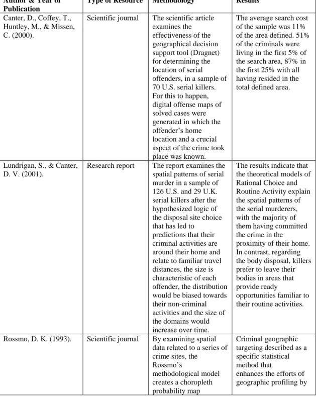
Table 1. The table shows the results from the articles used in the systematic literature review.
Author & Year of Publication
Type of Resource Methodology Results
Canter, D., Coffey, T., Huntley, M., & Missen, C. (2000).
Scientific journal The scientific article examines the effectiveness of the geographical decision support tool (Dragnet) for determining the location of serial offenders, in a sample of 70 U.S. serial killers. For this to happen, digital offense maps of solved cases were generated in which the offender’s home location and a crucial aspect of the crime took place was known.
The average search cost of the sample was 11% of the area defined. 51% of the criminals were living in the first 5% of the search area, 87% in the first 25% with all having resided in the total defined area.
Lundrigan, S., & Canter, D. V. (2001).
Research report The report examines the spatial patterns of serial murder in a sample of 126 U.S. and 29 U.K. serial killers after the hypothesized logic of the disposal site choice that has led to
predictions that their criminal activities are around their home and relate to familiar travel distances, the size is characteristic of each offender, the distribution would be biased towards their non-criminal activities and the size of the domains would increase over time.
The results indicate that the theoretical models of Rational Choice and Routine Activity explain the spatial patterns of the serial murderers, with the majority of them having committed the crime in the
proximity of their home. In contrast, regarding the body disposal, killers prefer to leave their bodies in areas that provide ready
opportunities familiar to their routine activities.
Rossmo, D. K. (1993). Scientific journal By examining spatial data related to a series of crime sites, the
Rossmo’s methodological model creates a choropleth probability map Criminal geographic targeting described as a specific statistical method that
enhances the efforts of geographic profiling by
12
indicating locations that are most probable to be associated with the offender’s home base, work site or travel routes. The methodology is also sensitive to the target/victim opportunity backcloth,
landscape issues, and problems of spatial “outliers”.
delineating the most probable
areas to which the offender might be associated
Rossmo, D. K. (2000). Scientific book Includes extensive tables and figures (Modus Operandi Matrix, Serial Killer Characteristics, Criminal Hunting Typology, Serial Murder Rates by State)
examining investigative applications such as task force management, data searches, DNA screens, and neighborhood canvasses. It also addresses serial murder, rape and arson; forensic behavioral science; criminal profiling; behavioral geography; predator patterns, including case studies and bibliography on serial murder, rape, and arson; the geography of crime; and
environmental criminology
The book presents geographic profiling theories and principles, including an extensive literature review and research in the areas of criminal profiling, forensic behavioral science, serial violent crime, environmental criminology, and the geography of crime.
Snook, B., Cullen, R. M., Mokros, A., & Harbort, S. (2005)
Scientific journal The journal examines the serial murderers’ spatial patterns and the factors influencing to choose the crime location, in a sample of 53 German serial killers.
The results showed that 63% of the murderers had lived within 10km of the locations they committed their crimes. The home-to-crime distance was negatively correlated with the serial killer’s age and positively with the murderer’s IQ score. Wang, F. (2005). Scientific book Fahui Wang has
included in his book a diverse and informative set of papers dealing with the GIS interface and crime analysis. The book is divided into six sections, with the third being used for the purpose of this dissertation.
Geographic profiling is of great interest in the discussion of the geographic crime analysis and it is interesting to examine the effectiveness of the method and also to evaluate it. In the third section of the book, there is an overview of the process followed by the presentation of a methodology
13
that could be used to develop a geographic profile based on a single incident while making a special reference to the geographic profiling in serial homicides.
How Geographic profiling works and under what conditions? Geographic profiling is only one piece of the pie in criminal
investigations. It is useful to understand how it works, by examining its role to the overall picture and the linkage to other behavioral science methods that are being implemented.
According to Rossmo, (2000), when crimes occur, there are some different steps that followed by the investigators and the police. Among those steps,
Geographic profiling plays a decisive role: Thus, firstly, there must be an occurrence of a crime series. Secondly, traditional investigative techniques are being implemented. If traditional investigative techniques are successfully
implemented, then the need for profiling is unlikely. If not, then a linkage analysis between the different crimes that occurred is progressing. After that, the criminal profiling comes to shed light on the investigation by determining offender’s characteristics. The fifth and last step is the conduction of the method is examined in this paper, the Geographic profile (Rossmo, 2000).
Further examining Geographic profiling, it is obvious that it has both quantitative (objective) and qualitative (subjective) components. The objective components by using a series of geostatistical techniques and quantitative elements like the Criminal Geographic Targeting (CGT) programs, analyze the point pattern as it is formed by target sites. On the other hand, the subjective element of Geographic profiling targets to the reconstruction and interpretation of the perpetrator’s mental map (Homant & Kennedy, 1998). These two types of profiles complete each other and act in tandem to help the investigators define a clear image of the offender who is responsible for the crimes are being
investigated (Rossmo, 2000).
To begin constructing a Geographic profile, many different crime factors need to be taken into consideration. First, Crime locations: It is the most
significant procedure analyzing the location of a crime scene in combination with times that offenses were committed. Secondly, investigators should consider the Offender type: And by that, we mean the type of crimes an offender commits, and the number of criminals took part, which overall affects crime geography. In connection with the offender type, if multiple criminals that live apart are involved, the geographic profile will target the dominant’s one’s home location. Creating beforehand a psychological profile could assist in the interpretation of the offender’s behavior, which is also important in the geographic investigation. The Hunting style: It should be considered during the preparation of a geographic profile. The Target backcloths1 that could limit the degree of offender’s choice influencing the importance of crime site types for the profile. Arterial roads and
1 The target or victim backloth comprises the form of the target or victim spatial distribution
within a given area (Brantingham & Brantingham, 1991). For instance, in such a case a killer seeks out specific type of victim e.g. prostitutes that their activity space is specific “hooker strolls”, and the attack locations are more influenced by the victim’s activity space rather than by the offender’s.
14 highways: People, including criminals, do not travel if there is a reason behind. And to travel someone first needs to count distances, arterial routes, freeways or highways. Bus and rapid transit stations: It is possible for criminals lacking vehicles, to use the public transportation or to travel along bicycle and jogging paths. All of the locations mentioned need to be considered. Physical boundaries, such as rivers, oceans, lakes, ravines, and highways might restrict offenders to move freely. Moreover, Psychological boundaries, such as criminals of low socioeconomic background might avoid an upper-class neighborhood to complete his/her criminal activities. Zoning such as residential, commercial or industrial and Land use such as stores, bars, business, major facilities and public buildings might be the answer to the question of why someone was in an area.
Neighborhood demographics that indicate specific ethnic or racial groups that offenders prefer to attack in some specific neighborhoods. Victim routine
activities patterns that provide the offender knowledge of the victims’ movements. Singularities and by that we mean the single incidents that do not appear to fit the overall image of the crime series, and this has to thoroughly examined and at the end, the factor of Displacement which indicates the media coverage or uniformed police presence that could cause spatial displacement having, as a result, the alternation of the locations of subsequent crime sites (Rossmo, 2000).
Generally, investigators follow the procedure of Geographic profiling when some specific conditions have been met. Thus, it takes the green light when a series of serious crimes that are probably linked to each other have occurred, and likely there is one offender to blame. Secondly, there should be at least five crime sites in the series of crimes, nevertheless in some cases, it is possible to proceed with fewer locations and finally, the investigations need to be serious enough to justify the time and the resources that need to start the profiling of the territories (Rossmo, 2014).
When the conditions described above have been met, then the
administration and the investigators request a Geographic profile. It can take approximately two weeks for the Geographic profile to be completed, of course depending on current cases load and requests are prioritized according to the level of community risk, for instance, murder over rape or current cases over historical ones, active perpetrators over the occasional ones. The eight steps of the process of the method’s preparation include at first a detailed research of the case file which includes investigation reports, witness statements, autopsy reports or if it is available the offender’s profile. Next, a detailed investigation of the scene of crime and photographs taken from the area. Third, interviews with the lead
investigators and crime analysts. A visit to the location of crime if that is possible. An analysis of the location and demographic data. Moreover, a study of the street, the land use or the transit maps needs to be done, an analysis of all the information gathered and finally the preparation of the report (Rossmo, 2000).
Geographic Information Systems (GIS)
For a Geographic profiling to be completed, there is the substantial need of the use of the GISs (Geographical Information Systems), that are automated systems for capturing, storing, retrieving, analyzing, and displaying the spatial data (Clarke, 1990, cited in Rossmo, 2000). According to Waters, (1998), almost 30% of the police agencies use computer-mapping software and the International Association of Crime Analysts (IACA) calculates that the need for GIS experts in the law enforcement sector has become ten-fold over the last 15 years. Using
15 these techniques patrol officers, detectives or police managers can understand faster the local crime patterns and trends resulting in better predictions when it comes to crime solving (Rossmo, 2000). One of the first systems designed for a similar field to Geographic profiling was the Spatial and Temporal Analysis of Crime (STAC), introduced by the Criminal Justice Information Authority (ICJIA) for the study of the existence, location, and size of hotspots (Block, 1993a; Block, 1995). It was used for analyzing homicides, drug, and liquor-related crimes, rapid transit impacts, gang crime and community problems (Rossmo, 2000).
It is true that the applicability of the GIS as a method of crime solving was recently recognized for serial murder investigations. The use of these systems can be viable as according to Rogers, Craig, & Anderson, (1991, p.17),
“Geographically coded information from police records can be used to detect crime trends and patterns, confirm the presence of persons within geographic areas, and identify areas for patrol unit concentration” (Rossmo, 2000).
Geographic profiling: locating the serial murderers Predicting the offenders’ residence
Until the development of the Geographic profiling in the 1990s, there was no any other similar systematic method except for the centrography, to deal with the offender’s most probable residence location (Benfer et al., 1991 cited in Rossmo, 2000). While Brantingham & Brantingham’s research handling the issue of the offenders’ activity spaces to explain where the crime is most likely to happen, Geographic profiling, in essence tries to alter this model by using this time the locations of the crime incidents as a resource to predict the most probable location of the offenders’ home or work base (Rossmo, 2000). The Rigel
Computer System is one of the most common programs the police and criminal investigators use for locating the home base of the serial offenders. It is a computerized geographic profiling workstation based on the patent CGT
algorithm, and it was developed by the Environmental Criminology Research Inc. (ECRI) of Vancouver, British Columbia. According to the specs of the program, it can rotate and visually manipulate “geo-profiles” and “jeopardy surfaces” in a variety of ways helping in their analysis (Rossmo, 2000).
Understanding the serial murderers
To begin with, homicides can take each time different dimensions regarding the offender and the type of crime s/he commits. It can be from a murder during domestic violence or murder for gain to multiple murders when the act is the primary objective in the offender’s mind. Consequently, one can
categorize several types of crimes among mass murders, sequential murders of known victims or serial homicides of strangers (Hill, 2004). In this paper, the primary focus is on serial murders and serial killers in order to understand the philosophy behind the motive and finally to find out how the Geographic profiling could contribute to locate and arrest them. When it comes to serial killers, one can categorize them in organized and disorganized offenders. Organized serial killers are methodical, they always plan before committing the murder and they select
16 vulnerable victims. On the other hand, disorganized serial killers have the
tendency to attack following their impulses (Wang, 2005).
Geographic profiling and the process of locating the serial murderers As already mentioned, the method of criminal geographic targeting through an analysis of the spatial information connected to a series of linked crimes tries to illustrate the most probable area of the offender’s home base. The process can analyze and examine the effects of anisotropic traveling, variable buffer zones, and nonuniform target backloths. Nevertheless, the calculations’ magnitude demands the use of a software program in order to get reliable results (Rossmo, 1993).
First, the borders of the map field are calculated through an addition of one-half of the average y and x inter-point distances, to the north-south and east west edges in parallel. Weighted circles are determined from the number of crimes and the hunting area’s size, are centered on the different crime locations, and scores then assigned to every particular point in the field. The circles overlap with each other creating a three-dimensional map in which the height or color of the different zones represents the possibility that the areas mentioned in the map include parts of the offender’s activity space. This means that the higher the elevation is, the greater is the probability (Rossmo, 1993).
With such information, the police departments can prioritize specific suspects of the many and the areas they act for investigative follow-ups and patrol saturation efforts. Moreover, new investigative leads can be developed from crime mapping, prioritized by the possibility factor with the help of a variety of
geographic data files. Criminal profiling can also be helpful in combination with the geographic profiling. All the clues matter when it comes to locating the criminals. For example, a Geographic profiling can prioritize zip or postal codes. If information about a suspect or a vehicle exists, prioritized zip and postal codes are used in the conduction of the investigation for the registered vehicle or driver’s license files contained in the state or provincial records (Wang, 2005). Locating the serial murderers through “Dragnet”
Canter, D., Coffey, T., Huntley, M., & Missen, C. (2000) in their study about predicting the serial killers’ home base using a decision support system, they tried to illustrate the effectiveness of a geographical decision support tool, the so-called “Dragnet” to locate the base of 70 U.S. serial murderers. According to the theoretical model of the “Circle Hypotheses” mentioned in the Theory section of the dissertation, we know that serial offenders tend to live or have a base of their activities within a circumscribed area around their offenses. Canter and Gregory (1994) developed the implications of the circle hypothesis showing that a simple computer-based geometric model including regions in a circle around the first offense was indicating with considerable success the general area of the offenders’ home base in a sample of serial rapists. The predicted search areas of the system were on average 19 km². This clue provides some value in terms of prioritizing areas, but it is not precise enough. For this reason, in this study Canter, D., Coffey, T., Huntley, M., & Missen, C. (2000) evaluate the
17 motifs and in helping to identify their home location. The methodology they followed to test the effectiveness of the Dragnet system was to develop digital offense maps and gazetteers for solved cases in which the home location and a location that a crucial fact of the crime took place was known. In this study, this crucial aspect was the victims’ body location. The variables were input into the flexible decision support system (Dragnet) as raw coordinates. In the sample that consisted of 79 serial killers from all over the United States, the offense series were between 2 to 24 crimes with a mean, 8; SD, 4.53 with distances ranging from 0 to 845 km with a mean 4.39 km; SD, 85.71 km. The results were interesting to discuss. Every home base of the 79 serial killers was located
between the search area defined by the “Dragnet” support system. The home base for 15% of the sample was identified within the first 1% of the rank-ordered areas, 51% within the first 5% of the locations, and 87% within the first 25%. Such a successful proportion of accurate findings shows that for the sample of the 79 U.S. serial killers, the system is highly effective in identifying the serial killers’ home base, and that there is high degree of substantive import between the
psychological assumptions that the system is built (Canter, D., Coffey, T., Huntley, M., & Missen, C., 2000).
A limitation of the study is that the results are a function of the dataset used. That means that only offenders who have been caught were included in the sample, so it is under question if their parameters of moving are same with the offenders’ who avoid getting arrest. Likewise, the models described applying to criminals that come to police attention because of uncovering the locations where the bodies of the victims had been disposed of (Canter, D., Coffey, T., Huntley, M., & Missen, C., 2000).
Which factors influence the serial murderers to choose the location of crime?
Snook, Cullen, Mokros, & Harbort, (2005), in their study consisted of a sample of 59 serial killers from the Federal Republic of Germany, tried to
examine the serial murderers’ spatial decisions and the factors may affect them in the decision-making process. Specifically, according to Rossmo, (2000), offenders select targets near their home location. Nevertheless, very little criminological and psychological research has been done examining the serial killers’ spatial
decisions. Specifically, Lundrigan and Canter (2001), supported that all of the criminal spatial decisions, including also the decisions made by the serial
murderers are arbitrated by social, economic, and cognitive factors including the development of the series of crimes, the age, the intellectual capabilities of the offenders, the employment and the marital status, the motivation of the offenders, and the means of transportation that they use. The effects of some of the
abovementioned factors have been previously examined in researches but not in relation to serial offending. The results of the study are interesting to discuss, also in relation to the geographic profiling as a method that could help in the
investigations of serial murders (Lundrigan & Canter, 2001).
According to the Snook, Cullen, Mokros, & Harbort, (2005) and the results of their study, the median home-to-crime distance was 6.5km (M=30.7km,
18 SD= 69.7km). Moreover, 156 (63%) of the 247 body recovery locations were situated in less than 10km from the killer’s home base. The 6.5% of the bodies were located within 1km of the offender’s location, 17% within 2km, 28% within 3km, 34% within 4km, and 45% within 5km. Additionally, 193 (78%) of the victims were at a distance within 20km or the murderer’s residence, and 206 (84%) within 30km. Longer than 100km distance from home-to-crime were found to be the 23 (9%) of the victims. Five serial killers were indicated for these 23 murders and 10 of the 23 were committed by just one murderer.
Regarding the test conducted to examine the factors influencing the decision for the location of the crime, in the series chronology factor showing the relationship between the number of murders and the common log of the median home-to-crime distance, it was found that the first location was closest to the offender’s residence in 47% of the incidents, the second was closest in 34% of the cases, and the third in the 36% of the cases. The Friedman test for the three mentioned samples showed that chronology of the crime locations was not significant by the home-to-crime distance perspective (χ2 = 1.602, p > 0.05). Finally, the relationship between the duration of a series in days and the common log of the median home-to-crime distance showed that despite the increasing length of time that series lasted, the offenders did not leave the victims farther from or in the proximity of their residence.
Examining the factor of age, the results indicated that as the murderer’s age was increasing, the median home-to-crime distance decreased which
practically means that older German serial killers were hiding the bodies of their victims closer to their home base than the younger criminals.
The intellectual capability chart showing the relationship between IQ score and the common log of the median home-to-base distance indicated that the higher the IQ scores the higher the home-to-crime distances.
Examining the marital status of the offenders with a Mann-Whitney test the results showed that the median home-to-crime distance for single serial murderers (Mdn = 12.0 km, M = 29.5 km, SD = 61.5 km) was not significant compared to the married offenders (Mdn = 10 km, M = 31.9 km, SD = 51 km), U = 203, p> 0.05). The median home-to-crime distance for divorced, murderers with diverse marital status or engaged did not count due to the small number of killers in these categories. The same happened to the murderers when their employment status was tested. It was not significantly different for the unemployed offenders. For the employed (10 km, M = 31.7 km, SD = 64.7 km) and for the unemployed (8.3 km, M = 18.6 km, SD = 27.2 km), U = 281, p > 0.05.
In terms of the factor of motive, the median-to-distance for the German serial killers motivated by sexual motives was 10km (M = 32.1 km, SD = 65.3 km) while it was 8.8 km (M = 21.1 km, SD= 38.3 km) for those with robbery intentions, and the difference between these two was not significant U = 308, p > 0.05.
Finally, testing the transportation factor, the most commonly used means of transportations was the car, the second one was walking following the public transportation. Here, the home-to-crime distance significantly differed between
19 the car users (M=15.5km), the offenders using the public transportation (M=5.9), and the murderers that walked (M=2.2km), c2 = 74.75, df = 2, p < 0.001.
From the results, we can conclude that the German serial murderers, in general, hide their victims’ bodies in the close territory to their home. The home-to-crime distance distribution follows a decay pattern whereas the possibility of hiding a body decreases as the distance from the offender’s home base increases. Moreover, intelligent serial killers travel farther from their territories to dispose of the bodies and intelligence is positively related to the home-to-crime distance between murderers. Furthermore, the murderers using car leave the victims’ bodies farther than those that use public transportation or walking, and the older ones are used to leave the bodies in the close proximity of their home (Snook, Cullen, Mokros, & Harbort, 2005).
The results of the Snook, Cullen, Mokros, & Harbort, (2005) study show an enormous potential for the implementation of the geographic profiling by the police officers in order to investigate the serial murderers and it may be useful in terms of providing the investigators with a location where they can begin
searching for the serial murderer.
DISCUSSION
According to the results of the systematic literature review that was conducted, Geographic profiling has an immense potential to work as an investigative method for locating the serial murderers or to suggest where the investigations should start for uncovering serial murder cases. The research questions were used for the conduction of the study was:
1. How Geographic profiling works and under what conditions?
2. How could the Geographic profiling be useful in order to locate serial murderers?
3. Which factors influence the serial murderers to choose the location of crime?
Having as an inspiration for this project, my perception as a citizen in Malmö that over the years has faced several shooting incidents, probably
committed by different gangs since we do not know if the crimes are connected to serial killers and on the other hand by having in mind the notorious serial killer Johan Peter Mangs, I had the scientific curiosity to learn more about the method of Geographic profiling, how it could work and what can the criminologists do in order to locate and finally help in arresting the criminals.
By analyzing how Geographic profiling works and what steps need to be done before the procedure can take the green light, one can understand the potential of this method in creating through computerized systems the
perpetrator’s mental map. Thus, the investigators can predict what moves the serial murderer might have done during his/her crimes and finally they can
identify their next moves in order to locate the most probable home position of the offenders.
20 As presented, for a geo-profiling to be done, a detailed research of the case is being conducted, including investigation reports, witness statements, autopsy reports or the offender’s profiling. Furthermore, an investigation of the crime scene begins, interviews with the investigators and visits to the crime area.
Finally, an analysis of all the aspects related to the crime and the crime location is being implemented and a report of the Geographic profiling is being prepared.
From the results, we can conclude that computerized programs such as “Rigel” or “Dragnet” are of utmost importance in the whole procedure in order to get valid results. According to Canter, D., Coffey, T., Huntley, M., & Missen, C. (2000) that tried to evaluate the effectiveness of such a development, “Dragnet” develops digital offense maps and gazetteers for solved cases in which the home location and the location of the victim’s body are known. According to the method, every home location of the 79 serial killers was located between the defined by the “Dragnet” area. This provides a significant potential to the method for future implementations with the only limitation that the results of the study were including only arrested serial killers. This means that it is not known if the moving patterns are the same with the offenders that avoid getting caught. But this could comprise an area for future development of the method, trying to identify how useful could the “Dragnet” be in researching non-arrested serial murderers, taking, of course, different parameters into consideration.
Finally, when examined which factors influence the serial murderers to choose the location of crime, the Snook, Cullen, Mokros, & Harbort, (2005) study showed that in a sample of 59 serial murderers, the criminals tended to dispose their victims’ bodies near their homes while certain factors seemed to be related when choosing their crime sites. IQ, mode of transportation, and age were found to be significant predictors of the home-to-crime distance. Even if from the results it is obvious that further research with bigger samples has to be conducted in order to determine the study’s reliability and the potential value of its indicators for police investigations, it should be possible for criminologists to make use of these findings for helping the authorities to predict the home location of serial
murderers in relation to the Geographic profiling.
Methodological considerations and limitations
For a study to be successful, some methodological issues need to be taken into consideration. The factors of Validity and Reliability is of utmost importance. In this systematic literature review, the purpose was the data found to coincide with the theoretical models described in the theory chapter. This was guaranteed by having determined the keywords used and by replying directly to the research questions were set at the beginning of the master thesis. Concerning the reliability of the project, a try was made to be as transparent as it could so as similar studies to be conducted for future developments (Bryman, 2008).
Some limitations while conducting the research on Geographic profiling and its applicability for locating the serial murderers were firstly that as an investigative method it is quite new, since it was first implemented in the 1990s, and there were limited resources of information in regard to Geographic profiling
21 being implemented in specific crime areas, such as in our case, in serial
homicides. The representation of the results was made based on six studies
(journals and books) that could precisely provide all the necessary information for the sake of the master thesis project. If the purpose of the paper was only to conduct a literature review of the method and how it works (question 1) of course the literature in the results section would be much broader. When a combination of subjects is being researched, then the options in literature significantly
decrease.
Practical and future implications
Although the use of Geographic profiling in police investigations seemed to rise, little is known about the actual procedure and more research needs to be done for future developments. Geographic profiling software has been around since the early 1990s, but the science of Geographic profiling seems considerably languished. The last 20 years the research on Geographic profiling has focused on developing new software platforms and in examining case studies, rather than on critically evaluating issues of effectiveness and accuracy. And maybe this is the reason why it is still not so widely used and known in more countries than the U.S., Canada and the U.K. Nevertheless, we should not forget that the potential of the method is huge and with more research and resources for further development, it could evolve in a way that it could provide noteworthy results in predicting the location of the serial offenders’ home base. Finally, it could also comprise an educational platform for future criminologists, where programs such as the Rigel or the Dragnet could be introduced as teaching materials for educational
Bachelor’s and Master’s programs in Criminology.
CONCLUSION
To sum up, the purpose of this master thesis dissertation was to present the investigative method of Geographic profiling, the conditions under which can work, how it helps in locating the serial murderers and which factors affect the criminals in choosing their crime locations. The results showed an enormous potential in the implementation of the method especially when there is the use of a computerized system like “Dragnet”. Moreover, the home-to-crime distance and the factors that influence the serial killers to choose their crime locations
uncovered. Even if the results have been presented seem really promising for future use and development of the Geographic profiling, it is true that more research must be done in the field. The only thing we can do as researchers is to continue exploring new innovative fields in the domain of Criminology without settling out, always with patience and inspiration.
22
REFERENCES
Benfer, R. A., Brent, Jr., E. E., & Furbee, L. (1991). Expert systems. Sage university paper series on quantitative applications in the social sciences, 77. Newbury Park, CA: Sage.
Bernasco, W. (2010). A Sentimental Journey To Crime: Effects Of Residential History On Crime Location Choice*. Criminology, 48(2), 389-416.
Block, C. R. (1993a). Automated spatial analysis as a tool in violence reduction. CJ the Americas, 6(1), 7-8, 10.
Block, C. R. (1993b). Lethal violence in the Chicago Latino community. In A. V. Wilson (Ed.), Homicide: The victim/offender connection (chap. 15). Cincinnati: Anderson.
Brantingham, P. J., & Brantingham, P. L. (1981). Introduction: The dimensions of crime. In P. J. Brantingham & P. L. Brantingham (Eds.), Environmental
criminology (pp. 7-26). Beverly Hills: Sage
Brantingham, P. J., & Brantingham, P. L. (1984). Patterns in crime. New York: Macmillan.
Brantingham, P. J., & Brantingham, P. L. (1998). Environmental criminology: From theory to urban planning practice. Studies on Crime and Crime Prevention, 7, 1-30.
Brantingham, P. L., & Brantingham, P. J. (1993). Environment, routine and situation: Toward a pattern theory of crime. In R. V. Clarke & M. Felson (Eds.), Routine activity and rational choice (pp. 259-294). New Brunswick, NJ:
Transaction.
Bryman, A. (2008), Social research methods, 3.th ed, Oxford University Press: Oxford.
Canter, D., & Larkin, P. (1993). The environmental range of serial rapists. Journal of Environmental Psychology, 13, 63 – 69.
Canter, D., and Gregory, A. (1994). Identifying the residual location of rapists. J. Forens. Sci. Soc. 34(3): 169–175.
Canter, D., Coffey, T., Huntley, M., & Missen, C. (2000). Predicting Serial Killers’ Home Base Using a Decision Support System. Journal Of Quantitative Criminology, 16(4), 457-478.
Clarke, K. C. (1990). Analytical and computer cartography. Englewood Cliffs, NJ: Prentice Hall.
Clarke, R. V., & Felson, M. (Eds.). (1993). Routine activity and rational choice. New Brunswick, NJ: Transaction.
Cohen, L. E., & Felson, M. (1979). Social Change and Crime Rate Trends: A Routine Activity Approach. American Sociological Review, 44(4), 588.
23 Cornish, D. B., & Clarke, R. V. (2014). The reasoning criminal: rational choice perspectives on offending. New York: Transaction
ECRI. (2002). www.ecricanada.com/news/index.html
Edwards, M. J., & Grace, R. C. (2006). Analysing the offense locations and residential base of serial arsonists in New Zealand. Australian Psychologist, 41(3), 219-226.
Felson, M. (1998). Crime and everyday life (2nd ed.). Thousand Oaks, CA: Pine Forge Press.
Forsberg, C. & Wengström, Y. (2015), 4. uppl. edn. Att göra systematiska litteraturstudier : värdering, analys och presentation av omvårdnadsforskning , Stockholm: Natur & Kultur.
Harries, K., & Lebeau, J. (2007). Issues in the Geographic Profiling of Crime: Review and Commentary. Police Practice and Research, 8(4), 321-333. Hill, M. (2004). Addicted to murder: The true story of Dr. Harold Shipman. London: Virgin Press.
Homant, R. J., & Kennedy, D. B. (1998). Psychological aspects of crime scene profiling: Validity research. Criminal Justice and Behavior, 25, 319-343.
Jeffery, C. R. (1977). Crime prevention through environmental design (2nd ed.). Beverly Hills: Sage.
Johansson A, Persson A. (2017). 22-årig man anhållen efter dödsskjutningen på Hermodsdal [22-year old man arrested after a person was shot dead in
Hermodsdal]. Sydsvenskan. 2017. Available from:
http://www.sydsvenskan.se/2017-01-03/person-skadad-i-skottlossningpa-Khoshnood, A. (2017). The increase of firearm-related violence in Sweden, Forensic Sciences Research, 2:3, 158-160
Lilly, J. R., Cullen, F. T., & Ball, R. A. (2015). Criminological theory: context and consequences. Los Angeles: Sage.
Lundrigan, S., & Canter, D. V. (2001). Spatial patterns of serial murder: An analysis of disposal site location choice. Behavioral Sciences and the Law, 19, 595–610.
MacKay, R. E. (1999, December). Geographic profiling: A new tool for law enforcement. The Police Chief, pp. 51-59.
McMurtry, R., & Curling, A. (2008). The review of the roots of youth violence. Toronto: Ontario.
Persson P, Persson A, Paulsson A, et al. (2017). Trolig brottsplats hittad efter skjutningen på Rosengård – fyra personer anhållna för mordförsök [Probable crime scene found after the shooting in Rosengard – four people arrested for attempted murder]. Sydsvenskan 2017. Retrieved from:
http://www.sydsvenskan.se/2017-01- 03/en-person-skjuten-i-rosengård
Petherick, W. (2014). Profiling and serial crime: theoretical and practical issues. Amsterdam: Elsevier.