JOURNAL OF
ENVIRONMENTAL HYDROLOGY
Open Access Online Journal of the International Association for Environmental Hydrology
VOLUME 28
2020
MULTI CRITERIA DECISION MAKING TO OPTIMIZE THE BEST
RUNOFF CONTROL MEASURES FOR THE HADITHA DAM
RESERVOIR, IRAQ
Ibrahim Abdulrazak Al-Ani1
Hayder A. Al-Thamery2
Nadhir Al-Ansari3
Ahmed Mohammed Sami Al-Janabi4
Wan Hanna Wan Mohtar5
1Department of Civil Engineering, Al-Farabi University College, Baghdad,
Iraq
2Department of Water Resources Engineering, University of Baghdad,
Baghdad, Iraq
3 Department of Civil Environmental and Natural Resources Engineering, Lulea University of Technology, Sweden
4Department of Civil Engineering, College of Engineering, University
Putra Malaysia, Serdang, Selangor, Malaysia
5Department of Civil & Structural Engineering, National University of
Malaysia, Selangor, Malaysia
In Iraq, the two dominating surface water sources are Tigris and Euphrates Rivers in which some dams constructed on both of them forming reservoirs. The Haditha Dam reservoir is one of the most essential sources of drinking, irrigation, flood control and hydropower generation in Anbar State, Western Iraq. Besides, the reservoir is a unique habitat with a wide spectrum of biodiversity. The objective of this study is to investigate and monitor the water quality in Haditha Dam reservoir and introduce Multi Criteria Analysis (MCA) as a means to highlight the best runoff control measures depending on selected criteria and criteria weights. Experts were interviewed for the selection of criteria and for the assignment of the weight factor and scores. Four criteria from three categories such as technical, economic and environmental aspects were selected. Results from this study indicated that a the difference in TSS and Turbidity between the dry and wet seasons necessitates the installation of runoff control measures. It was found that the soil binders, sediment basin and diversion channel are the best alternatives for controlling erosion, sediment and drainage respectively. The sensitivity analysis showed very strong decisions made by the experts for the technical, economic and environmental criteria.
INTRODUCTION
A very high percentage of water (around 97%) of Earth's surface water is salty and few remaining percentage (around 3%) is a freshwater [1]. With such a high quantity of water and/or abundance around us, why are millions of people in the world dying from insufficient access to potable water?. One of the basic human rights is to have an access to a clean drinking water [2]. Clean and sufficient quantity of water provides the needs of irrigation, industrial and commercial uses, hydropower generation and recreation. Although it is essential to our lives, however, urban development, population growth, periodic drought and climate change should be highly considered over the continued availability of stable and dependable supply of freshwater for our nation [1].
Iraq is part of the Middle East which covers an area of 433970 square kilometers and populated by 32 million capita [3]. The main resources of fresh water are the surface water and the ground water. The surface water is characterized by Tigress and Euphrates. Tigress and Euphrates are considered the two rivers out of world's 26 major river basins [4]. The water in the Tigris-Euphrates river basin originates from the Minor Caucasus and the Taurus Mountains in the Anatolia Plateau located in the northwest region of Turkey. Both of them flow from southwest Turkey into the Arabian lands crossing Syria and Iraq. They converge with the Karun River to form the Shatt al-Arab in the surroundings of Al-Qurna which is located 70 km northeast of Basra which discharges its water into the Arabian Gulf.
Water shortage is a real problem in Iraq as the desert occupies a large part of the country. The current networks also have been suffered from lack of maintenance or by being destroyed during the war. Besides, the water sources are generally contaminated chemically and biologically due to the lack of suitable systems for safe disposal of sewage from different sources (i.e. medical, agricultural, industrial and so on). According to the Ministry of Water Resources, 32 percentages of Iraqis has an access to clean drinking water and only 19 percentages has an access to an acceptable sewage system [5] and [6]. There are few dams constructed on both of Tigris and Euphrates for providing the sufficient storage of water to be used for the various purposes. In addition to the facts mentioned earlier, the very high temperature which accompanied with high evaporation rates and low rainfall [7] has a great impact on the quantity of water available in storage reservoir. Fig. 1 illustrates the average annual rainfall in Iraq for the duration (1991-2015).
Fig.1. Average annual rainfall in Iraq (Reference [8])
Euphrates River Basin is considered as the longest river in western Asia. With the construction of large water engineering structures in upstream Turkey and Syria, the Euphrates flow pattern has been changed to less seasonal variation. Water use in the Euphrates Basin targeted for irrigation, drinking water supply, and hydropower generation. Water quality has become a serious issue on the Euphrates
River: return flows from agricultural drainage cause salinity problems that are exacerbated along the river course. In addition, dumping of untreated sewage into the Euphrates and its tributaries contributes to other forms of water pollution [9]. [10] conducted a study to assess the water quality of Euphrates River from three different sites and has been indicated that the river suffers from different sources of pollution. [11] assessed the water quality of Al-Kufa River for drinking water using the GIS and the Water Quality Index (WQI) and concluded the high values of the WQI is due to various human activities close to the river. Furthermore, the application of GIS and WQI can serve a good tool to highlight the river pollution due to different uses and water resource management.
Runoff water quality control impose multiple criteria usually with different units need to be considered and weigh as option. The Multi Criteria Analysis (MCA) is an effective tool to make decisions with high accuracy and it has widely been applied in water resources and environmental management fields [12, 13, 14, 15, and 16]. MCA make decisions based on criteria selection, criteria's weights and ranking of alternatives against criteria. Sensitivity Analysis is used to check the reliability and strength of the decision made by the MCA [17]. This paper aims to adopt a successful monitoring program of water quality for Haditha Dam reservoir to verify whether the observed water quality is suitable for the intended uses and to recommend the suitable control measures. Furthermore, highlight the best control measure using MCA technique based on consultation with the local experts. Fig. 2 illustrates Tigris and Euphrates River Basins in which ES1 shows the location of Haditha Dam on
Euphrates River.
Fig.2. Tigris and Euphrates River basins
STUDY AREA
Haditha Dam which is located in Anbar State is considered the largest dam across Euphrates River which was constructed by the former Soviet Union in 1987. This dam which is an earth fill dam with 10 km length has formed Haditha reservoir which covers an area of 500 km2 and storage volume of
9.25 billion m3. The dam which stores the water for drinking, flood control and generating electricity is
located about 40 km from Anah city and 120 km from the Syrian border. The height of the dam is 75 m and 325 m in width. The crest width is 20 m. The level of the reservoir is ranged between 110-170 a.s.l. Fig. 3 shows the reservoir and the location of the dam on the Euphrates River. Fig. 4 depicts the contour line of Haditha reservoir.
Fig.3. Google image for the study area
Fig.4. Contour line of Haditha reservoir [Reference 5]
MATERIALS AND METHODS
The methods adopted in the current research involve monitoring the water quality in the reservoir, identify the major sources of pollution and developing MCA matrix to identify and/or highlight the best runoff control measure. The following sections clearly illustrate each part separately. Fig. 5 illustrates the methods adopted in the current research.
Fig.5. Overall framework adopted in the current study
Lab Work Field Measurement
Data Collection
Experts Judgement Experts Judgement MCA Model Development
Experts Judgement
Experts Judgement
Water Quality Monitoring
The study of surface water quality monitoring for Haditha Dam reservoir involves selecting the sampling locations, sampling parameters and sampling frequency. The collected samples were measured in Laboratory. Seven locations were selected for taking the samples as shown in Fig. 6 which are limited locations due to the difficult security situation in the region. Sample handling varies with the type of sample. Some samples are collected from the boats anchored at the monitoring sites and are labeled and other samples were collected near the beach. The water quality parameters that have been monitored include pH, Total Suspended Solids (TSS) and Turbidity. Sampling are conducted once in each of May, June, July and August where there is no precipitation and are conducted once also in each of December, January and February where the maximum precipitation occur. The purpose of collecting samples in wet season is because the surrounding area is a desert which is experiencing high soil erosion rates once rainfall occurs.
Fig.6. Water quality sampling locations
Runoff Control
In order to improve the water quality in the reservoir due to the polluted runoff, some runoff control measures need to be installed. This requires controlling the erosion at source using erosion control measures, capturing the sediments carried by runoff using sediment control measures and using safe runoff drainage measures. Since the rainfall events in Iraq occur in few months within the year solely, all the measures adopted herein are temporary measures which showed very high efficiency in improving runoff quality [18, 19 and 20]. The permanent measures are mostly applied in tropical regions since they are mostly kept wet and for high rainfall intensities and/or long duration throughout the year round.
Table 1 illustrates the various types of control measures that can be adopted and applied in the area of the study in which these measures were adopted from international guidelines and manuals [21, 22, 23].
Multi Criteria Analysis Model Development
In this research, the weighted summation multi criteria analysis technique is adopted, which was introduced and developed by Reference [24]. This method is one of the most used techniques applied in the water resources and environmental management fields [25, 26 and 27]. In this technique, the performance measures were multiplied by the weights and then summed for each alternative to obtain a performance score. The overall performance score was calculated using Equation 1, as follows:
Table 1: Runoff control measures
Category Management Practice Description
Erosion control Geotextile Made of natural or synthetic materials which are used to temporarily stabilize soil. They are targeted to stabilize the disturbed soil and to protect soils from erosion by the impact of runoff.
Seeding and planting Long term stabilization of soil can be provided by seeding and planting of trees, shrubs, grasses and ground covers.
Soil binders Materials are applied to the soil surface to temporarily prevent water induced erosion of exposed soils on construction sites.
Sediment control Silt fence Filter fabric stretched across and attached to supporting posts and entrenched. The filter fence is constructed of stakes and synthetic filter fabric with a rigid wire fence backing when necessary for support.
Sand bag barrier consists of bunds of sand bags for lining areas that are prone to soil erosion and flood. These bags are stacked along a level contour to create a barrier, which detain sediment laden water by ponding upstream of the barrier water, thus enhancing the sedimentation.
Drainage inlet protection Devices used at storm drain inlets that are subject to runoff from construction sites to detain or to filter sediment laden runoff to allow sediment to settle or filter sediment prior to discharge into storm drainage systems or watercourses.
Drainage control Earth bank Earth bank is a ridge of compacted soil or gravel which is used to divert runoff to a desired location, convey surface runoff down slopping land, and diverts water towards a stabilised watercourse or channel.
Diversion channel Divert runoff and used to direct runoff into the sediment traps and basins.
Slope drain Slope drain is a temporary pipe or lined channel to drain the top of slope to a stable discharge point at the bottom of a slope without causing erosion.
vi=
∑
j=1 m sij. wj (1) where,sij = standardized performance measure for xij;
vi = value (or utility) of the ith alternative relative to the other alternatives.
An important part of the Multi Criteria Analysis was the ranking of the runoff control alternatives against the criteria. The researchers have combined all the criteria that have been selected by the previous case studies, pertinent references, review of literature and then presented them to the local experts through comprehensive discussions. Experts were contacted and consulted regarding the alternatives (runoff control measures), criteria, assigning weight to the criteria and ranking of
alternatives against the criteria. There are three interview sessions were organised with 7 experts who classified into two groups (i.e. university academics denoted as Group 1, and practicing engineers denoted as Group 2). The brief and sequence of events of the meetings are presented in Table 2. The interview with the experts followed a structured communication in which a convergence opinion is achieved. After each round, each anwer from different experts were compiled and summarised. Following each interview session, the answers compilation from the previous round was presented to the expert panels. During this session, the experts may revise their answers back in light with other panels or remained with their prior answers. This process facilitates the coherence of feedback and decreasing the variation of answers given which eventually the specific group will conclude to unanimous answer. The interview and reiterate processes were stopped following the impediment criterion umber of rounds, achievements of the consensus and stability of the results. The mean scores of the final rounds determine the results. The first consultation was important to build rapport with the experts and researchers. During the interview, the specific goals and questions for the knowledge acquisition session were prepared. A set of representative problems was formulated and discussed them with the experts. Some other issues that have been discussed include the types of multi criteria analysis that have been applied in water resources field, runoff control measures and the essential criteria required for establishing an MCA model. After the final meeting, the experts identified the appropriate runoff control measures, criteria required for making the decision, weighting the criteria and ranking of alternatives (runoff control measures) against the criteria. Based on expert's consultations, three main criteria and their weights were identified by the domain experts; that are technical, environmental, and economic criteria. Fig. 7 illustrates the selected criteria for the decision making. Weights are assigned to the criteria based on their importance.
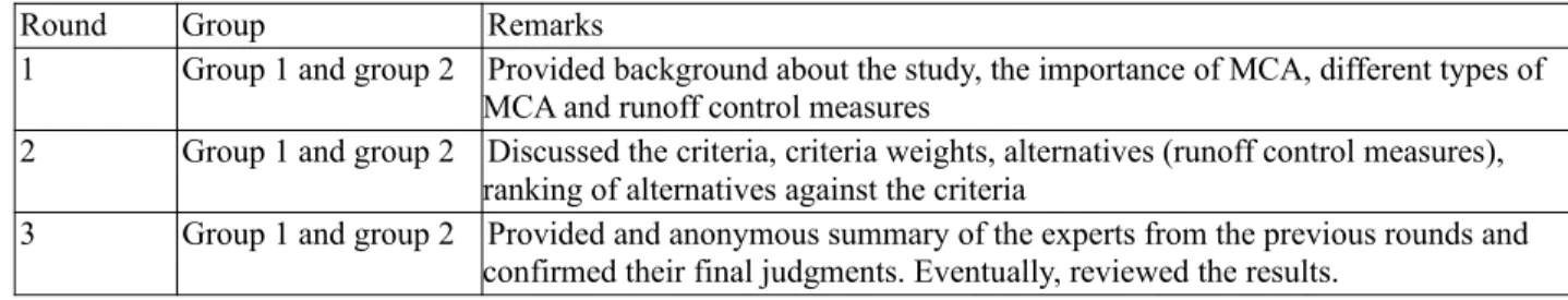
Table 2: Sequential interviews with the experts
Round Group Remarks
1 Group 1 and group 2 Provided background about the study, the importance of MCA, different types of MCA and runoff control measures
2 Group 1 and group 2 Discussed the criteria, criteria weights, alternatives (runoff control measures), ranking of alternatives against the criteria
3 Group 1 and group 2 Provided and anonymous summary of the experts from the previous rounds and confirmed their final judgments. Eventually, reviewed the results.
Each of these criteria was sub-criterion. Sidek et al. (2008); Chowdhury and Rahman (2008) and local experts recommended that sub-criteria are necessary. The ranking was performed based on the type of criterion whether it is benefit or cost criterion. The benefit criteria (i.e. technical and environmental) had the ordinal scales of 1 to 5, where 1 and 5 indicate the criteria of “very low” and “very high”, respectively which is contrast with the cost criterion that had the ordinal scale of 1 to 5, where 1 and 5 indicate the criteria of "very high" and "very low" respectively. Negative sign given for the economic criterion.
Performance Matrix
Assessment of the performance matrix X of n decision options (runoff control alternatives) against
m criteria was conducted by obtaining the performance score for decision option i, with respect to
criterion j is denoted as xij., as shown in Fig. 8. Each criterion is subscribed to one dimensional weight,
denotes here as wj, that is the weight assigned to the jth criterion.
As mentioned earlier, each criterion was assigned weight which indicates the relative importance of each criterion. Typically, the ∑wj = 1 and 0 ≤ wj≤ 1, holds for all the criteria; that is, the sum of the
Fig.7. The hierarchy of runoff control contributing to Haditha Dam Reservoir
Fig.8. The basic structure of the performance matrix
weights is equal to one and is non-negative. Criteria weights were assigned by the experts in whom they have been normalised to add up to one. Variations in the performance matrix alternatives/runoff control measures were represented as columns, and the criteria and weights as rows. The performance matrix represents the domain of factors, which is incorporated into the MCA model to generate its solutions.
As suggested by Voogd (1983), the best alternative was considered as the one with the highest performance score xij. Due to the choices made in the Multi Criteria Analysis were on the basis of
evaluation method, sensitivity analysis is needed to be conducted. The sensitivity analysis was performed by alternately changing the weight coefficient for all the criteria i.e. technical, environmental and economic. When the weight for one criterion was changed, weights for other two criterions remained constant.
RESULTS AND DISCUSSION
Results from this study includes the comparison between selected water quality parameters in both of the dry and wet seasons in Haditha Dam reservoir in which the wet season shows high level of pollution due to the introducing of the runoff into the reservoir. Due to the high level of pollution, the MCA Technique was introduced to highlight the best runoff control measure. The subsequent paragraphs explained the results obtained from this study with discussions.
Water Quality Monitoring Results
Three water quality parameters were monitored in the reservoir; they are PH, Total Suspended Solids (TSS) and Turbidity.
pH
pH has been measured for both of dry and wet seasons in the locations clarified earlier. Fig. 9 below illustrates the pH values for the 7 locations measured in dry and wet seasons in which the pH in
Locations 1, 3, 4, 5 and 6 drop below the desired Iraqi standard (pH = 6.5-8.5) after rain which can be attributed to the acidic rainfall.
Fig.9. pH values in dry and wet seasons
Total Suspended Solids (TSS)
Total Suspended Solids concentrations indicate a wide difference between the dry and wet seasons in which the concentrations in wet season increased to almost six times compare with the dry season concentrations as clarified in Fig. 10. The very high level of TSS is attributed to the runoff which is accompanied with sediments from the eroded soils.
Fig.10. TSS values in dry and wet seasons
Turbidity
Turbidity is another indicator which has been measured in this study and expressed great difference between the dry and wet season as shown in Fig. 11 below. The high level of Turbidity is attributed to the runoff which is accompanied with sediments from the eroded soils.
Optimizing the Best Runoff Control Measure
Scores of alternatives against criteria are presented in Tables 2, 3 and 4 for the erosion, sediment and drainage control respectively. It is observed that the removal costs of erosion, sediment and drainage control measures are assigned similar scores. Negative sign is used for economic scores.
Table 2: Scores of alternatives with respect to criteria for erosion control
Erosion Control Best Alternative
Alternatives Criteria Sub-criteria Normalized Weights I II III Technical System performance & durability 0.236 5 3 4 Economical Installation cost 0.250 -3 -3 -2
Removal cost 0.250 -4 -4 -4 Environmental TSS Control 0.263 5 4 5
I: Geotextiles & Mats, II: Seeding and Planting, III: Soil Binders
Apply Equation (1) to the results of ranking as shown in Table 2, the recommended best runoff control measure to minimize the soil loss is Soil Binders.
Table 3: Scores of alternatives with respect to criteria for sediment control
Sediment Control Best Alternative
Alternatives Criteria Sub-criteria Normalized Weights I II III Technical System performance & durability 0.236 4 3 5 Economical Installation cost 0.250 -3 -4 -2
Removal cost 0.250 -3 -3 -3 Environmental TSS Control 0.263 4 4 5
I: Silt Fence, II: Sand Bag Barrier, III: Sediment Basin
By applying Equation (1) to the results of ranking as shown in Table 3, the recommended best runoff control measure to capture the sediments is Sediment Basin.
Table 4: Scores of alternatives with respect to criteria for drainage control
Drainage Control Best Alternative
Alternatives Criteria Sub-criteria Normalized Weights I II III Technical System performance & durability 0.236 4 5 3 Economical Installation cost 0.250 -3 -2 -2
Removal cost 0.250 -3 -3 -3 Environmental TSS Control 0.263 3 4 3
I: Earth Bank, II: Diversion Channel, III: Slope Drain
Apply Equation (1) to the results of ranking as shown in Table 4, the recommended best runoff control measure to capture and drain the water to a safe place is Diversion Channel.
Impacts of sensitivity analysis on the choice of the best alternative are given in Fig. 12, Fig.13 and Fig.14 for the best erosion, sediment and drainage control respectively.
Fig.12. Effect of changing criteria on the choice of best erosion control
Fig. 12 (a, b and c) illustrates the effect of changing the criteria on the choice of best erosion control in which each time one criterion's weight remained constant and the rest two criteria got change in there weights. This procedure applied to each of the technical, economic and environmental criteria as shown in (a), (b) and (c) respectively. It is clear that changing the weights doesn't affect the choice of the best alternative and hence the decision made is strong.
Fig.13. Effect of changing criteria on the choice of best sediment control
Fig. 13 (a, b and c) above clarifies the effect of changing the criteria on the choice of best sediment control. Changing the weights of each criteria and maintaining the rest two criteria doesn't change the decision of the best alternative. Again, the decision is strong against technical, economic and environmental criteria.
Fig.14. Effect of changing criteria on the choice of best drainage control
As shown in Fig. 14 (a, b and c), changing the weight factor of each of the technical, economic and environmental criteria and maintaining the weight of the rest couple of criteria constant doesn't affect the decision of the best alternative.
a
b c
a
b c
CONCLUSIONS
In any development project seeking to improve the water quality, public awareness and community participation should be an integral component of activities aiming at promoting hygienic practices and avoiding hazardous practices that involve serious risk to human life and natural resources. Results from this study showed a serious contamination in Haditha Dam reservoir which is considered as a vital source for drinking, irrigation, recreation and so forth for an area of one third of Iraqi lands. The TSS and Turbidity values for the samples measured after rain increased to a very high level as compared with the samples measured in dry season and this can be attributed to the runoff entered from the banks of the reservoir which is accompanied by soil dislocation. This emphasis on installing erosion control measures and sediment control measures so as to minimize the soil erosion and trapping the sediments before being introduced into the reservoir.
MCA results in highlighting the best alternatives based on input from the local experts prove to be very strong and consistent in which it doesn't has sensitivity to any of the technical, economic and environmental criteria when the weights changed.
Eventually and due to the importance of this reservoir, it is recommended to take more samples to have more representative and dependable date for the decision makers. It is also recommended that more experts' opinions obtained and integrate it to a decision support system in order to give decisions (to the level of an expert) and can work as a green technology tool in maintaining good quality of the reservoirs' water.
ACKNOWLEDGMENT
Authors are highly thankful to the experts whom helped in developing the MCA model through their consultation.
REFERENCES
[1] Z. Ujang, R. Abd.rahman, A. N. Anuar, Current trends in water quality and resources management, Proceedings of the 1st Technical Meeting of Muslim Water Researchers Cooperation (MUWAREC)
(2008), Malaysia.
[2] United Nations News Center. 2010. General Assembly declares access to clean water and sanitation is a human right. [Online]. Available: http://www.un.org/apps/news/story.asp? NewsID=35456 [Accessed on August, 27th 2017].
[3] N. Al-Ansari, A. A. Ali, S. Knutsson, Present conditions and future challenges of water resources problems in Iraq, Journal of Water Resource and Protection 6 (2014) 1066-1098.
[4] Space Study Program, Tigris Euphrates and the global water crisis. International Space University, (2011).
[5] Stars Orbit Consultants and Management Development, Water quality control and surveillance in Iraq (Phase II), World Health Organization, Unicef (2010).
[6] A. H. H. Ahmed, Study the effect of evaporation on water quality to the Iraq reservoirs, Journal of Babylon University/Engineering Science 3 (2015) 638-649.
[7] K. A. Rahi, Z. N. Abudi, Rainwater harvesting techniques applied to some Iraqi zones, Journal of Engineering and Development 2 (2015) 82-90.
[8] World Bank Group. Climate Change Knowledge Portal. Iraq:
http://sdwebx.worldbank.org/climateportal/index.cfm?page=country historical climate & This Region=Africa & This Code=Iraq [Accessed on March, 3rd 2017].
[9] United Nations Economic and Social Commission for Western Asia, Inventory of shared water resources in Western Asia. Beirut, Lebanon (2013).
[10] H. M. Salman, M. N. Jasim , J. M. Salman, A GIS assessment of water quality in Euphrates River/Iraq, Journal of Babylon University/Engineering Sciences 2 (2015)
[11] M. A. Alanbari, S. S. Alqizweeni, R. A. Abdalwahed, Assessing of water quality of Al-Kufa River for drinking water using WQI and GIS, International Journal of Current Engineering and Technology 4 (2017) 1566-1571.
[12] I. A. Al-Ani, W. H. W. Mohtar, N. E. A. Basri, L. M. Sidek, Development of a hybrid expert system-multi criteria analysis on erosion and sediment control in construction industry, KSCE Journal of Civil Engineering 20 (2016) 3045-3056.
[13] A. Yazidi, S. Saidi, N. B. Mbarek, F. Darragi, Contribution of GIS to evaluate surface water pollution by heavy metals Case of lchkeul Lake (Northern Tunisia), Journal of African Earth Sciences 134 (2017) 166-173.
[14] A. E. IIaya-Ayza, C. Martins, E. Campbell, J Izquierdo, Gradual transition intermittent to continuous water supply based on multi-criteria optimization for network sector selection, Journal of Computational and Applied Mathematics 330 (2018) 1016-1029.
[15] L. K. Singh, M. K. Jha, V. M. Chowdary, Assessing the accuracy of GIS-based multi-criteria decision analysis approaches for mapping groundwater potential, Ecological Indicators 91 (2018) 24-37.
[16] J. Vishnupriyan, P. S. Manoharan, Multi-criteria analysis for renewable energy integration: A southern India focus, Renewable Energy 121 (2018) 474-488.
[17] J. H. Voogd, Multi-criteria evaluation for urban and regional planning, Delftsche Uitgevers Maatschappij Pion, London, (1982).
[18] I. Gogo-Abite, M. Chopra, Performance evaluation of two silt fence geotextiles using a tilting test-bed with simulated rainfall, Geotextiles and Geomembranes 39 (2013) 30-38.
[19] L. A. Sanudo-Fontaneda, S. J. Coupe, S. M. Charlesworth, E. G. Rowlands, Exploring the effects of geotextiles in the performance of highway filter drains, Geotextiles and Geomembranes 5 (2018) 559-565.
[20] D. Briassoulis, A. Giannoulis, Evaluation of the functionality of bio-based plastic mulching films, Polymer Testing 67 (2018) 99-109.
[21] Colorado Department of Transportation, Erosion control and stormwater quality field guide, (2011).
[22] C. J. Macgregor, Guidelines for erosion and sediment control at building sites in the south west of WA, Centre of excellence in natural resources management, University of Western Australia and the South West Catchments Council, (2008).
[23] City of Auburn Community Development and Public Works Department, Supplemental manual to the DOE stormwater management manual for Western Washington, Volume 1, minimum technical requirements and site planning, (2017).
[24] K. Schlager, The community-the rank-based expected value method of plan evaluation: Highway Research Record (1968) 153-158.
[25] S. Hajkowicz, K. Collins, A review of multiple criteria analysis for water resources planning and management, Water Resour Manage 21 (2007) 1553-1566.
[26] R. K. Chowdhury, R. Rahman, Multicriteria decision analysis in water resources management: the Malnichara channel improvement, International Journal of Environmental Science and Technology 5 (2008) 195-204.
[27] L. M. Sidek, H. Basri, Z. Zalaluddin, Development of decision support tools for urban storm drainage. Proceedings of the International Conference on Construction and Building Technology, (2008), Selangor, Malaysia.
ADDRESS FOR CORRESPONDENCE

![Table 1 illustrates the various types of control measures that can be adopted and applied in the area of the study in which these measures were adopted from international guidelines and manuals [21, 22, 23]](https://thumb-eu.123doks.com/thumbv2/5dokorg/5502545.143316/5.918.326.592.374.584/illustrates-various-control-measures-adopted-measures-international-guidelines.webp)