ENVIRONMENTAL HEALTH ISSUES IN HIGH
ALTITUDE AREAS OF SAGARMATHA
(EVEREST) NATIONAL PARK AND BUFFER
ZONE (SNPBZ)
Kumud Raj Kafle
Sanjay Nath Khanal
Kathmandu University, Nepal
ABSTRACT
Sagarmatha (Everest) National Park, Nepal Himalayas, central part of the Hindu Kush Himalayas (HKH) has been experiencing neo-environmental health problems in spite of being dubbed as “virgin land and virgin Himalayas with high altitude fresh people”. So far, the common myth in the high altitude places has been only High Altitude Sickness (HAS), however other anthropogenically induced diseases such as diarrhoea, dysentery, Acute Respiratory Problem (ARP), unusual fever and parasitic worm infection have been commonly observed. Altogether 4 health stations with an average 7hrs trekking apart are not sufficient to cater to more than 20,000 tourists per year with their guides & porters and almost 6000 resident population.
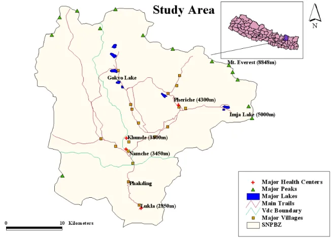
Four health centers (Lukla 2850m, Namche 3450m, Khunde 3800m, and Pheriche 4300m) are the main health care units in this region. Poor accessibility and limited resources have caused further constrains to meet the demands of the visitors and locals.
The current researches and observations indicate that the waterborne diseases and diseases related to food are the new emerging health issues in the area. The trend is higher in lower altitude area than in the higher altitudes. Poor sanitation, huge amount of manure and its uses, traditional open toilets and open defecation, unhygienic pigsties and cattle sheds, poor drainage system in the major settlements are the major contributing factors. The recent studies have also indicated the acceleration of contamination of water and water bodies from different human induced sources. Awareness and education on health hygiene and sanitation, proper waste management, accessibility of potable water without further polluting the water sources
interesting biological species (Jha, 2010). Tourism (trekking and expeditions) is a major business in this region.
Figure 1. Study area map.
The major trekking routes are to the Everest Base Camp (EBC), Gokyo Lake and Island Peak. There are two peak seasons: pre-monsoon (March, April and May) and post-monsoon (August, September and October). Over 1,333 households are present in the region. Almost 50 % households are directly benefited from tourism business. The number of international visitors has been on the rise (Bhuju, 2010).
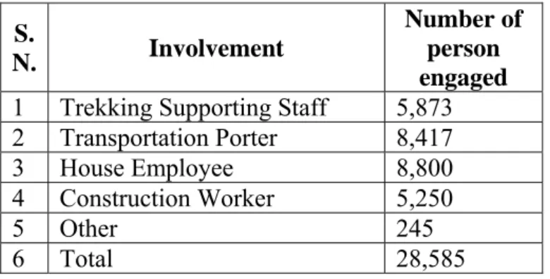
Table 1. Trekking staffs involvement in SNPBZ
Source: Sharma, 2008
The Mt. Everest region has been experiencing neo-environmental health problems in spite of being dubbed as “virgin land and virgin Himalayas with high altitude fresh people”. So far, the common myth in the high altitude places has been only High Altitude Sickness (HAS), however other anthropogenically induced diseases such as diarrhoea, dysentery, acute respiratory problem, unusual fever and parasitic worm infection have been commonly observed. Altogether 4 health centers with an average of 7hrs trekking apart are not sufficient to cater to more than 20,000 tourists per year with their guides & porters and almost 6000 resident population.
In the last few years, a number of food and water related diseases have been reported by visitors (http://www.mounteverest.net, 2005) as well the locals (Sherpa, 2010). Contamination in water bodies in the Sagarmatha National Park and its Buffer Zone (SNPBZ) has accelerated in recent years. Recent research has shown (Ghimire et al. 2010), that 13 percent of water samples has bacterial contamination. The research has further reported that even mineral water is contaminated with bacteria. Poor toilet conditions and use of manures are the major cause of water contamination. 20% of households don’t even have toilets. Out of 2,197 tons of manure that is produced in the region annually, eight tons of manure is used per hectare of arable land. The excessive use of manure contaminates the water bodies (NGO forum, 2009). High number of open toilets and unmanaged solid wastes are major sources of environmental degradation in the Sagarmatha region. Although human waste have not been taken seriously
S.
N. Involvement
Number of person engaged
1 Trekking Supporting Staff 5,873 2 Transportation Porter 8,417
3 House Employee 8,800
4 Construction Worker 5,250
5 Other 245
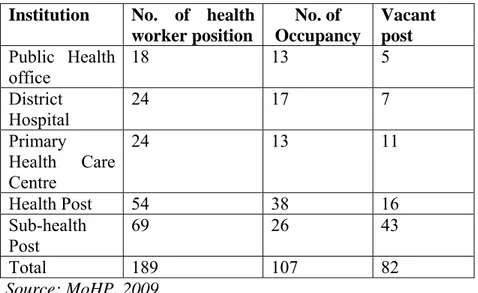
hospital and provide health service throughout the year to the local people as well as the visitors (see Table 2). Most of the expedition teams have their own doctors and medicines and they are not generally visited in those health centers. More than 20,000 visitors and their support staff (Porters and Guides) along with the local residents depend on these hospitals. However, the health centers in Solukhumbu district in general , in the government health services system are understaffed (with 43% still lying vacant) and with limited services and facilities (see Table 3).
It is obvious that every trekking season is the most potential time for disease out breaks because of intense social and economic activities of tourism. According to the previous health records according to MoHP, 2009, the major health problems in the region are worm infestation (8.9%), Upper Respiratory Track Infection (URTI) (6.06%) and gastritis (5.78%) followed by diarrhoea and dysentery (sum of 5.8%). At present, the incidence of some of these diseases has increased.
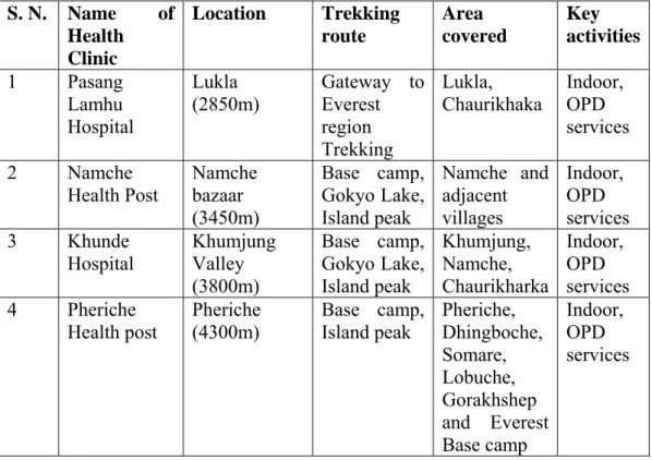
Table 2. Major health centers and their services/provisions
S. N. Name of Health Clinic Location Trekking route Area covered Key activities 1 Pasang Lamhu Hospital Lukla (2850m) Gateway to Everest region Trekking Lukla,
Chaurikhaka Indoor, OPD services 2 Namche Health Post Namche bazaar (3450m) Base camp, Gokyo Lake, Island peak Namche and adjacent villages Indoor, OPD services 3 Khunde Hospital Khumjung Valley (3800m) Base camp, Gokyo Lake, Island peak Khumjung, Namche, Chaurikharka Indoor, OPD services 4 Pheriche Health post Pheriche (4300m) Base camp, Island peak Pheriche, Dhingboche, Somare, Lobuche, Gorakhshep and Everest Base camp Indoor, OPD services Source: MoHP, 2009
Table 3. Status of the health workers in Solukhumbu district
Institution No. of health worker position No. of Occupancy Vacant post Public Health office 18 13 5 District Hospital 24 17 7 Primary Health Care Centre 24 13 11 Health Post 54 38 16 Sub-health Post 69 26 43 Total 189 107 82 Source: MoHP, 2009 3 FIELD TRIP
A 15 days field trip was conducted for the study during April 2010 covering the areas from Lukla (2,850m) to Imja Lake (5,000m), Everest Base Camp and Kalapathar (5,640m).
During this trip, data was collected from all the four health centers along the trekking routes. Field observation and documentation, interviews with doctors, questionnaire surveys from tourists were conducted.
4 RESULTS AND DISCUSSION
A total of 1,644 patients’ (15 %) data of spring 2010 from health centers were analyzed. Data related to pregnancy and delivery cases were not included.
The data were categorized into 5 classes:
• Diseases Related to Food and Water (DRFW) • Diseases Related to Air Pollution (DRAP)
Figure 2. Major disease categories in SNPBZ area.
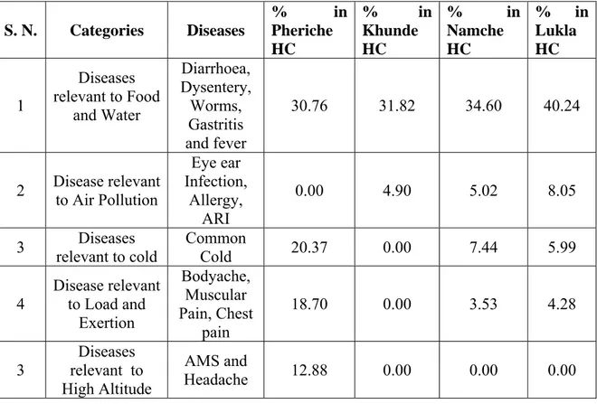
The incidence of DRFW is 30.76% in Pheriche (4,300m) and 40.24% in Lukla (2,850m). Similarly DRAP is 0.00% in Pheriche and 8.05% in Lukla (see Table 4). This indicates that the trend of DRFW and DRAP are higher in lower elevation. This may be due to higher temperature in lower elevations and human interventions/activities are also much more than that in upper elevation areas. Similarly, the higher elevation areas are relatively moist and the incidence of DRAP is less.
Table 4. Diseases in different health centers (HC) along the main trekking routes
S. N. Categories Diseases % in Pheriche HC % in Khunde HC % in Namche HC % in Lukla HC 1 Diseases relevant to Food and Water Diarrhoea, Dysentery, Worms, Gastritis and fever 30.76 31.82 34.60 40.24 2 Disease relevant to Air Pollution Eye ear Infection, Allergy, ARI 0.00 4.90 5.02 8.05
3 relevant to cold Diseases Common Cold 20.37 0.00 7.44 5.99
4 Disease relevant to Load and Exertion Bodyache, Muscular Pain, Chest pain 18.70 0.00 3.53 4.28 3 Diseases relevant to High Altitude AMS and Headache 12.88 0.00 0.00 0.00
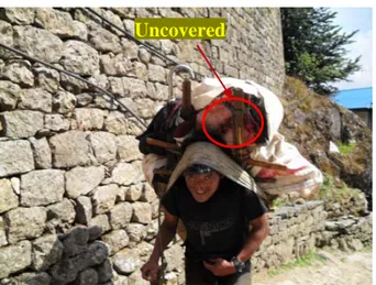
Figure 3. Meat Transporting from Southern Part of the SNPBZ area.
Most of packed/ tinned foods are brought from Kathmandu. It was observed that meat and dairy products are brought from southern part of the region which may take 2 to 3 days from Lukla. The means of transportation is either by porters or by animals like Jyokko (Hybrids of cow and yak) and yaks. Meat products may be contaminated during transportation as these were seen carried without being covered (see Figure 3).
The DRHA and DRC were prominent at higher elevation. It is obvious that in higher elevation the temperature and atmospheric pressure are lower than that of the lower elevation areas. The major age group who suffers from these diseases is between 18-50 years (65.64%). It was found that 58.86% of sufferers were male and it is because of the male dominancy in trekking business.
It was also found that more than 20% foreigners were affected by anyone of the diseases during their trek. Recent research also supports that the pollution in water bodies is in increasing trend towards the lower elevations.
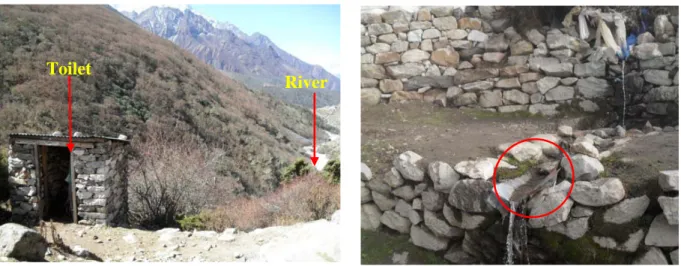
Figure 6. Toilet on the terrace of the river (at Somara).
Figure 7. Rusted tin sheet (drinking water) at Dhingboche.
Toilets near to the river courses, open defecations, unhygienic pigsties and cattle sheds, poor drainage system in the major settlements are the main contributing factors that had been observed during the field trip. The major problems observed in villages are in the table (see Table 5)
Table 5. Observed environmental problem along the main trekking route villages
Trekking Route Villages
Environmental Problems Indicators
Lukla Open defecation, Cloth washing in tributaries, poor drainage system,
Washing in river, excreta in the field, wet and water in the village route
Phakding Poor drainage, open urination, less toilets
Wet and water in the village route, wet and smell along the route
TokTok Unhygienic pigsties, metal
contamination in water, toilets near by the river
Pigsties in riverbank terrace, constructed toilet near by the river Namche Open defecation, Cloth Washing
in tributaries, unmanaged cattle sheds, poor drainage system
Washing in river, cattle in elsewhere, wet and water in trails Dingboche Poor drainage, unmanaged water
sources and cattle sheds
Wet and water around route, rusted tin used on the drinking water
Chhukum Toilets near to the river Toilet pits near the river Lobuche Poor drainage, Cloth wasting in
the river, unmanaged cattle sheds, dumping area near to river
Wet and water around the village, washing in the river, dumping pit on the riverbank
Toilet
5 CONCLUSION
There are several environmental and health-related issues which need to be addressed .The diseases in SNPBZ area can be categorized into 5 classes. DRFW are emerging health issues in the area and the distribution of diseases is related to altitude. DRFW and DRAP are more pronounced in lower elevation areas whereas DRHA and DRC are more pronounced in high altitude areas. Awareness and education on health hygiene and sanitation, proper waste management, accessibility of potable water without further polluting the water sources in major trekking routes and settlements, adequate health services are necessary for maintaining good health as well as a sustainable social and economic development in SNPBZ.
6 ACKNOWLEDGEMENT
The study was conducted as a component of joint Ph. D. program of Kathmandu University and LAQUA group Sweden (constituting Linnaeus University formerly Kalmar University, Lund University and Kristianstad University) to give us an opportunity to visit and collect the data from SNPZ area. We are especially grateful to Prof. Dr. William Hogland and Prof. Dr. Lenart Martinson of LAQUA group Sweden. We are also thankful to Dinesh Manandhar from Kathmandu University to help us in the field trip.
REFERENCES
[1] Bhuju, U. K., 2010, Visitors Survey in Sagarmatha National Park, Nepal Contemporary Research in Sagarmatha (Mt. Everest) Region, Nepal, 1, Nepal Academy of Science and Technology, Khumaltar, Lalitpur.
[2] Ghimire N. P., B. B. Shrestha, G. U. Caravello and P. K. Jha, 2010. Sources of Water Pollution in Sagarmatha National Park and Buffer Zone, Nepal, Contemporary Research in Sagarmatha (Mt. Everest) Region, Nepal, 103-104., Nepal Academy of Science and Technology, Khumaltar, Lalitpur.
[3] http://www.mounteverest.net, 2005, BaseCampMD - Khumbu cough, HAPE and chilblains on Everest's South Side, April 28, 2005.
[4] Jha, P. K. 2010. An Overview of Sagarmatha (Mt. Everest) Region, Nepal. Contemporary Research in Sagarmatha (Mt. Everest) Region, Nepal,p.1, Nepal Academy of Science and Technology, Khumaltar, Lalitpur.
[5] Khanal S. N., R.B. Kayastha, R. K. Maskey, K. R. Kafle, S.Bhochhibhoya, G. Chaudhari, R. Pandey and Y. Sherpa, 2010, A Study on Solid Waste Management in Sagarmatha National Park and Buffer Zone (SNPBZ)., Contemporary Research in
[9] Sherpa K., 2010, Local resident as well as Doctor, Interview taken at Khunde Hospital, Khumjum Valley.
[10] Tabei, J. 2001. Climbers’ impact on the natural environmental in mountain areas and environmental conservation: Present situation of wasters left by climbers in the Mount Everest region. In: Proceeding of the International Symposium on the Himalayan Environment: Mount sciences and Ecotourism/Biodiversity. Eds.T.Watanatse, S. Sircroff, N. R. Khanal and M. P. Gautam. Hokkaido University, Japan and Tribhuvan University, Nepal, 6-13.