Dynamic route planning in the Baltic Sea:
How can the negative impacts of maritime traffic on
sensitive or protected areas be reduced?
2
Foreword
This report has been written by Kjell Larsson and commissioned by the World Wide Fund for Nature, WWF. Its purpose is to illustrate how the adverse effects of shipping on conservation values and biodiversity in sensitive or protected areas can be reduced by dynamic route planning in the Baltic Sea.
The author works as a Professor of Ecology at the Gotland University and is visiting professor at the Kalmar Maritime Academy, Linnæus University. The author is solely responsible for the contents and conclusions of this report.
Visby 20 January 2012 Kjell Larsson
Author’s address:
1 Kalmar Maritime Academy, Linnæus University, SE-391 82 Kalmar, Sweden 2 Gotland University, SE-621 67 Visby, Sweden, kjell.larsson@hgo.se
3
Summary
Dynamic routing means that ships to a greater extent than today are assigned individual routes based on the traffic situation, weather and other prevailing conditions. Dynamic route
planning, in addition to reducing the risk of accidents and ship fuel consumption will also, if used correctly, significantly diminish the adverse impact of shipping on the marine
conservation values of sensitive or protected areas. An active and dynamic route planning that takes into account sensitive natural environments in the Baltic Sea is also a way for the
shipping industry and shipping administration to interact with the marine spatial planning process necessary to achieve an improved marine environment in accordance with Sweden's environmental objectives, the Helsinki Commission (HELCOM) Baltic Sea Action Plan and the EU Baltic Sea Strategy and Maritime Policy.
The environmental impact of shipping can be measured on different spatial and temporal scales. The impact of CO2 emissions from shipping on the atmosphere is global, while other types of emissions to air and water may have well-defined regional or local effects. The effects on the marine environment can be direct or indirect, prolonged or short-lived. The environmental effects of shipping may also interact with the environmental effects brought about by other activities. Additionally the effect of a given discharge or emission on the marine environment is not only dependent on the size of the discharge or emission, but also to a great extent on where and when they take place.
Dynamic route planning means that trade-offs must be made between different factors. These trade-offs must be part of a holistic approach and rest on a sound factual basis. Decision makers will be faced with situations where they are forced to make a choice between avoiding the risk of direct negative effects on habitats, species and biodiversity and avoiding additional emissions to air. The outcomes of such trade-offs will vary in different areas of the Baltic Sea and at different seasons.
Dynamic route planning must be adaptive, i.e., the parties involved must be aware that conservation values, natural resources and the maritime fleet in the Baltic Sea are subject to change and adapt planning to cope with these changes. We now have enough knowledge to start using dynamic route planning to reduce the direct adverse effects of shipping on the marine conservation values of sensitive or protected areas. However, if planning is to be effective and trade-offs between different factors and interests more accurate we need to add to our knowledge.
4
Introduction
Integrated sea use management seeks to reconcile long-term usage with the protection of marine values and resources. It can be used to achieve an effective and wise management and, hence, to fulfil the objectives of the HELCOM Baltic Sea Action Plan and the EU Integrated Maritime Policy as well as the environmental goals adopted by the Swedish parliament. Marine spatial planning is a tool to practically share the seas various services between stakeholders in an environmentally sustainable way, ensuring that marine ecosystems remain healthy and biodiversity is conserved. In the Baltic Sea activities such as international
shipping, offshore wind power, fishing, oil exploitation, the laying of power cables and pipelines must be coordinated with measures designed to protect biodiversity, tourism and recreation. Conflicts between users of the sea and between use and protection are in many cases inevitable. When such conflicts arise a sound factual basis and comprehensive overview are necessary if trade-offs between different public interests are to be even-handed.
The Baltic Sea is used extensively as a means to move goods, and the cargo transportation service that shipping provides is extremely important. At the same time shipping gives rise to major negative environmental and health impacts in the form of emissions to air and water. In many areas work is underway to reduce the adverse environmental effects of maritime
transport. The development of eco-friendly technologies and the introduction of economic instruments to promote the use of better fuels are some examples in these areas. However, further efforts to reduce the impact of shipping on the environment are needed.
Improved ship route planning can reduce a number of the negative environmental impacts caused by shipping. Dynamic route planning by which ships to a greater extent than today are assigned individual routes based on prevailing conditions is one important tool. Dynamic route planning can contribute (1) to a reduction of the total consumption of marine fuel and harmful air emissions, but will also help (2) reduce or prevent the adverse effects of shipping on conservation values and biodiversity in sensitive marine areas.
The environmental impacts of shipping can be measured on different spatial and temporal scales. The impact of CO2 emissions from shipping on the atmosphere is global, while other types of emissions to air and water may have well-defined regional or local effects. Effects on the marine environment can be direct or indirect, prolonged or short-lived. The environmental effects of shipping may also interact with the effects of other activities. The effect of a given discharge or emission on the marine environment is not only dependent on the size of the discharge or emission, but also to a great extent on where and when they take place.
In this report, I will investigate how dynamic route planning can be used to reduce the adverse impacts of shipping on conservation values and biodiversity in sensitive or protected areas in the Baltic Sea. I will begin with a brief discussion of the conditions that I use as starting points in the continued discussion of shipping routes in the Baltic Sea. I will describe briefly how shipping can affect air and water environments, habitats and species, and how adverse effects can often be reduced. I also highlight situations where it may be necessary to weigh the various negative environmental impacts of shipping against each other. This is followed by a description of the situation in two areas in the Baltic Sea where the conflict between shipping and nature conservation is especially evident. I conclude by discussing the additional knowledge that I consider necessary if dynamic route planning is to effectively diminish the negative impacts of shipping on marine conservation values.
5
Shipping is an important mode of transport in the Baltic Sea region
Transport by sea in the Baltic Sea region is extensive. Approximately 90% of all goods to and from Sweden are carried by ship. The importance of maritime freight is at least as great in the other Baltic countries. A large proportion of Russia's oil exports go by sea from the Gulf of Finland and on into the Baltic Sea and North Sea.
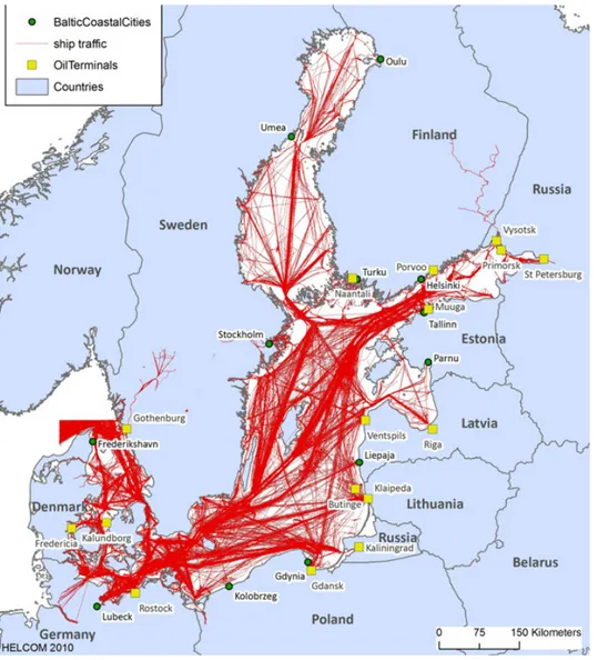
Approximately 2000 ships are estimated in transit on the Baltic Sea at any given time (HELCOM 2010) (Figure 1). Heavy ship traffic in the central Baltic Sea east and west of Gotland totals about 57 000 vessel passages per year, of which up to 20% are carried out by tankers. Today an overwhelming proportion of ships in the Baltic Sea follow static routes recommended by traffic separation schemes. Shipping in the Baltic Sea is expected to increase in the years to come. Shipping is an international business. More than half of the ships sailing the Baltic Sea are registered in countries outside the Baltic Sea region. Many ships have international crews – irrespective of where they are registered. However, cargos are usually destined to ports in the Baltic Sea region or in Europe.
Figure 1. Ship traffic in the Baltic Sea based on the HELCOM AIS during one week in November 2008 (Figure from HELCOM 2011)
6
The Baltic Sea is a sensitive sea
The Baltic Sea is an ecosystem that due to the small volume of water it contains, low water exchange rates and stratified water layers, is particularly sensitive to eutrophication and various types of environmental toxins and pollutants. The number of species of plants and animals in the Baltic Sea is significantly lower than in, e.g., Skagerrak and the North Sea. In the Baltic Sea several marine and freshwater species live on the boundaries of their natural habitats. These species may be particularly sensitive to the stress triggered by eutrophication and the spread of various types of oils, chemicals and other contaminants. In a biological perspective the Baltic Sea is a productive sea that provides socio-economically very valuable natural resources and ecosystem services. Large quantities of fish are landed annually from Baltic fishing grounds. The Baltic Sea is also an important breeding and wintering area for many of Europe's marine bird species.
The Baltic Sea is not a homogeneous marine region
Conservation values and natural resources in the Baltic Sea are unevenly distributed over the surface. Some areas of the Baltic Sea are much richer in species, individuals or more sensitive than other areas (HELCOM 2009, Havsmiljöinstitutet 2011). For example, large extents of the sea bottom in the central and deep areas are anoxic and have virtually no benthic fauna.
However, offshore banks and shallow coastal areas can be extremely species-rich and be home to large numbers of individuals during the whole or part of the year. Some areas of the Baltic Sea are particularly important for bird and fish breeding, foraging and overwintering. For example, more than 90% of the millions of wintering seabirds and sea ducks in the Baltic Sea are concentrated in areas that in total cover less than 5% of the Baltic Sea surface
(Durinck et al. 1994, Skov et al. 2011).
Several areas in the Baltic Sea have been identified as particularly valuable
and sensitive
With the exception of some Russian water areas the entire Baltic Sea has been classified as a “Particularly Sensitive Sea Area (PSSA)”, by the International Maritime Organization (IMO). In conjunction with the decision to classify the Baltic Sea as a PSSA, so-called “Associated Protective Measures” or APM's were also established. The decided APM's included traffic separation schemes in the southern and central Baltic Sea, and the boundaries of the two areas which shipping is recommended to avoid – so-called “Areas to be Avoided”. The entire Baltic Sea is also classified by IMO as a “Special Area” under the International Convention for the Prevention of Pollution from Ships (MARPOL), annexes I, IV, V, and VI. Areas defined as Special Areas by MARPOL have more stringent requirements on emissions from ships (IMO 2011).
In some cases sensitive marine areas in the Baltic Sea have been given protection in the form of nationally decided nature reserves, or EU designated Natura 2000 sites. HELCOM has also designated a hundred sensitive areas as “Baltic Sea Protected Areas (BSPA)”. EC Habitats and Birds Directives require member states to maintain specified conservation values in designated Natura 2000 sites regardless of whether threats to these values are to be found
7 inside or outside these sites. Two marine areas, Hoburgs Bank and Northern Midsjö Bank, have been classified by IMO as “Areas to be Avoided, (ATBA)”. A recommendation that ships should avoid these areas is usually printed on nautical charts. Information about Natura 2000 sites is not usually marked on nautical charts.
Some areas have been given protection based on several different classifications. The exact boundaries of protected areas with the same name designated by different authorities are not always identical. For example, the boundaries set for the Natura 2000 areas Hoburgs Bank and Northern Midsjö Bank by the EC do not exactly match the boundaries decided upon by IMO for the ATBA Hoburgs Bank and Northern Midsjö Bank (Figure 2). This is also the case for the Baltic Sea Protected Areas established by HELCOM that are not always consistent with the Natura 2000 sites and ATBA areas.
Figure 2. Map of Hoburgs Bank and the southern tip of Gotland. The Natura 2000 site Hoburgs Bank is the area inside the marked 35 m depth contour. The area within straight black lines is the area IMO recommends that ships avoid. The black arrows indicate how vessels in the current busy shipping route, about 28 000 ships per year, between the south-western Baltic Sea and the Gulf of Finland cross a part of Hoburgs Bank. The black line around the southern tip of Gotland shows where inventories of oil-contaminated birds have been carried out annually since 1996/97.
Shipping has major negative environmental impacts
Although shipping is generally capable of transporting large volumes of cargo at low cost and CO2 emissions per tonne-kilometre are much lower than for many other means of transport, shipping has a variety of negative effects on the environment. The shipping in the Baltic Sea causes significant emissions of various pollutants to water and air. These emissions occur both during normal operation and when there are accidents, but also take place as deliberate and illegal acts. Operational and illegal discharges to water mainly occur along the major shipping routes (Figure 3).
8 Figure 3. Oil spills detected by HELCOM countries surveillance flight between 1998 and 2004. In total 2719 discharges were registered (HELCOM 2011). Discharges occurred principally along the major shipping routes. There is also an unknown number of undiscovered oil spills. (Figure taken from http://serac.jrc.it/midiv/ in November 2007).
Although oil spills were more frequent and substantial in the 1980s and early 1990s, the number of illegal oil discharges is still high today – several hundred per year in the Baltic Sea. The index that the HELCOM Baltic Sea Action Plan recommends for measuring changes in the number of oil discharges in the Baltic Sea – the number of spills per flight hour detected by HELCOM countries' surveillance aircraft – has not decreased over the past six years (Figure 4). The many small oil spills from ships cause that tens of thousands of seabirds die in the Baltic Sea each year. Some years more than 100 000 birds have been killed by the spills that take place in sensitive areas. These minor oil spillages come only to a limited extent from oil tankers – they usually come from other vessels.
So far the Baltic Sea has been spared major tanker oil spills. A large oil discharge in the Baltic Sea will certainly have a far-reaching and costly impact on the natural environment and society in general. It is difficult to predict which part of the Baltic Sea will suffer the most from such a discharge.
Ship-to-ship collisions between vessels other than tankers and groundings can also cause large discharges of oil. Larger vessels now often carry up to 1000 tons of bunker oil or more in their fuel tanks. Ship fuel tanks often have less protection against groundings and collisions than tanker holds. In recent years accidents in the Baltic Sea have clearly shown that discharges of bunker oil can be substantial. The occurrence and effects of spills of chemicals other than oil products in the Baltic Sea are poorly understood.
9 Figure 4. Number of oil spills in the Baltic Sea detected from the air divided by the number of hours completed aerial surveillance per year (data from HELCOM 2011). This relative measure, along with the number of detected and confirmed oil discharges, is used as an indicator to establish the effectiveness of the HELCOM Baltic Sea Action Plan. The indicator value “Pollution per Flight Hour (PF)” has not declined significantly since 2005 when the Baltic Sea was classified by IMO as a “Particularly Sensitive Sea Area”
The total emission of nitrogen oxides, NOx, to air from shipping in the Baltic Sea is
considerable. It has been estimated to be equal – at least 370 thousand tonnes NOx / year – to all land-based emissions of NOx in Sweden and Denmark combined (Stipa et al., 2007,
HELCOM 2010). Emissions of NOx to the air and the subsequent deposition to the sea and on land leads to increased nitrogen loading, eutrophication effects, acidification and the
formation of particles and harmful ground-level ozone. How close to the emission source deposition occurs depends on winds and precipitation. A large portion of the deposition of NOx from shipping in the Baltic Sea will likely occur in the Baltic Sea or in the catchment area of the Baltic Sea. Eutrophication effects in the Baltic Sea can probably not be linked geographically to the exact distribution of shipping routes. If major shipping routes are located near the coast there may be a public health risk due to NOx emissions from shipping. Emissions of sulphur oxides, SOX, and particulate matter (PM), from shipping is extensive. Although stricter requirements for reduced sulphur content in bunker fuel will be introduced in 2015 for ships operating in the Baltic and North Sea, SOX emissions will be significant even then. Dissemination of SOX may occur over large distances. As is the case for NOx emissions the general effects of SOX emissions – e.g., general acidifying effects and health effects – cannot be exactly pinpointed to shipping routes in the Baltic Sea. If the major shipping routes are located near the coast the site-specific effects of SOX emitted by shipping on human health might increase. The environmental effects of any discharge of process water used in on-board scrubbers when SOX and particulates are separated from flue gas can
10 According to calculations shipping in the Baltic Sea consumes about 5.6 million tonnes of bunker fuel per year during normal operations, resulting in major CO2 emissions (Stipa et al., 2007). The environmental impact of CO2 emissions from shipping is global and has no direct relation to where vessels are operating.
Due to the handling of large quantities of ballast water shipping may also contribute to the spread to the Baltic Sea of foreign organisms from other oceans. If the treatment and cleansing of ballast water cannot be performed the exchange of ballast water should be principally carried out in the North Sea before ships sail into the Baltic Sea. The problem of ballast water management is thus not directly connected to the whereabouts of shipping routes in the Baltic Sea.
Negative environmental impacts from shipping can be reduced
Shipping emissions and negative environmental effects can be substantially reduced if international and national conventions, directives, laws and regulations are tightened and tougher economic instruments are introduced. Increased pressure to improve ships' environmental performance can be expected from cargo owners in the years to come. The technology that will significantly cleanse ship exhausts from NOx, SOX and PM has already been developed and installed on several vessels in operation. Alternative fuels for marine engines are under development. In the near future liquefied natural gas (LNG) will provide an alternative that will reduce NOx, SOX and PM emissions drastically. Substantial reductions in CO2 emissions can be obtained by for example eco-driving or deceleration. The number of illegal oil spills can be reduced if the penalty when detected is much greater than today, and if cargo owners to a much greater extent are held publicly accountable for how and in which ships their cargos are transported.
Groundings and ship-to-ship collisions can result in major spills to water and have a considerable environmental impact. The commonest oil spill accident is the discharge of bunker oil as fuel is often stored in unprotected tanks just inside the hull. An improved shielding of bunker tanks would reduce the risk of this.
Minor and major accidents to shipping in the Baltic Sea can never be wholly prevented. Deliberate oil discharges and emissions caused by ignorance or carelessness can without doubt be further reduced with training and information. But all experience to date, and studies of the human factor, shows that emissions from ships cannot be completely avoided. There will be deliberate discharges and emissions due to accidents and carelessness along the major shipping routes for the foreseeable future. However, the risk that oil or other chemical spills will have a major impact on the natural environment will be radically reduced if the busiest shipping routes are shifted away from the Baltic Sea’s most sensitive, species-rich and protected areas.
Dynamic route planning that takes into account prevailing winds and currents can reduce ship fuel consumption and emissions of CO2 into the air. Deceleration, eco-driving and improved passage planning to avoid delays outside ports reduces fuel consumption and air emissions. A
11 general speed reduction for vessels of a few per cent will decrease air emissions radically. Dynamic route planning, if implemented properly, will also reduce the negative effects of shipping on conservation values and biodiversity in vulnerable or protected areas by not assigning ships routes close to sensitive and protected areas at sensitive times of the year.
Balancing the environmental impacts of shipping
In all social planning, including marine spatial planning, it is necessary to compromise
between different types of use and different types of protection. Shipping in the Baltic Sea has an important transport role but also a major negative impact on the surrounding environment and gives rise to significant environmental costs (Johansson et al., 2010). Fortunately, it is possible to take measures to greatly reduce many kinds of adverse environmental effects simultaneously, without significantly increasing the shipping cost to the end user of the goods. For example, a transition from high viscous Heavy Fuel Oil (HFO), to Liquefied Natural Gas (LNG), as the main fuel for shipping on the Baltic Sea would reduce both emissions of NOx, SOX and PM and emissions of CO2. Similarly, a speed reduction will decrease several types of air emissions at the same time.
At times it is necessary to evaluate and choose between equally sound measures to reduce adverse environmental effects. One measure designed to reduce the risk of a negative environmental effect may mean running a higher risk of incurring another detrimental environmental effect.
Removing SOX from flue gases on board ship using a scrubber system requires a certain amount of energy, which in itself may increase fuel consumption and CO2 emissions. New technology to clean oily water in various tanks from, e.g., 15 ppm to lower levels has been developed, however this requires additional energy that will give rise to more CO2 emissions. Clean-up operations that use chemical agents to break down oil spills may reduce the damage to bird life as sticky oil disappears from the water surface but may lead to regional diffuse or indirect toxic effects on fish and benthic fauna when the oil is dissolved in water.
The trade-offs are even more difficult when the direct and indirect environmental effects we wish to diminish occur along very different spatial and temporal scales. How is a known negative but diffuse indirect effect – e.g., emissions to air – to be weighed against the risk that an area worthy of protection might be affected by a major negative direct effect? How far from an area of high conservation value should ship routes be drawn to ensure that the risk that the area will be damaged by an oil spill will be acceptably low?
Future dynamic route planning in the Baltic Sea must be based on a holistic approach. The fact that there may be internal conflicts between different types of measures taken to reduce negative environmental impact from shipping must be accepted. Internal contradictions must be clarified, analysed and evaluated with great care. Previous analyses of the environmental impact of shipping in the Baltic Sea have often recommended standard, across-the-board measures, without analysing inherent contradictions or consequences in detail.
12
Two examples of conflict areas in the Baltic Sea – Hoburgs Bank and
Salvorev
In many of the deeper areas in the central Baltic Sea, normal shipping can operate without any major direct measurable impact on habitats, species or biodiversity. In other parts of the Baltic Sea, including some offshore banks, shallow areas and near the coast, there are significant areas of conflict, i.e., areas where maritime use poses a major threat to conservation values. The following describes how the situation stands today at two such areas of conflict, i.e., Hoburgs Bank and Salvorev (Figure 5), and how the conflict could be reduced with the help of dynamic route planning. The conflict situation in these two areas described below does not mean that there are not conflicts in other parts of the Baltic Sea that are just as serious. There is a great need to continue identifying the main conflict areas in the Baltic Sea.
Figure 5. Examples of two areas where there are serious conflicts between maritime use and protection of conservation values. Salvorev is located north of Gotland. Hoburgs Bank is located southeast of Gotland. Background image with red lines shows ship traffic
(Sjöfartsinspektionen 2007)
Hoburg Bank and Salvorev – conservation values and current protection
Hoburgs Bank is located south of Gotland and is a 15-30 meter deep approx. 1230 km2 shallow area consisting of a number of stone and gravel banks with intervening deep valleys and crevices (Länsstyrelsen Gotlands län 2005a, Naturvårdsverket 2006, 2008a, 2010). The
Salvorev
Hoburgs Bank
Deep-water route
Main route
approx. 28 000 passages per year13 area is mainly located in the Swedish exclusive economic zone, ie., in the Swedish EEZ. The north-western part of Hoburgs Bank is located in Swedish territorial waters within 12 nautical miles from the coast of Gotland. The bottom is covered with patches of rich mussel beds. The area is an important wintering area for seabirds and sea ducks, mainly for the European population of long-tailed duck and the black guillemot. In the years 1992-93 more than 900000 long-tailed ducks were estimated to winter in the area – i.e., approximately 25% of Europe's population (Durinck et al., 1994). The European long-tailed duck population has declined sharply over the past 20 years, due, among other things, to increased mortality as a result of oil spills. Hoburgs Bank remains one of the most important wintering areas in the Baltic Sea (Skov et al., 2011). The area is also an important spawning ground for turbot and a traditionally important cod and turbot fishing area.
Hoburgs Bank is an EU designated Natura 2000 site, a HELCOM Baltic Sea Protected Area (BSPA), and has been identified as an Important Bird Area (IBA), by BirdLife International. IMO has also designated a part of the Natura 2000 site as an area to be avoided by shipping (Figure 2).
Salvorev is located north of Gotland and extends between the islands of Fårö and Gotska Sandön in Swedish territorial waters (Länsstyrelsen Gotlands län, 2005b, 2010). The area consists of gravel and sand banks at about 8-30 meters depth. Parts of the reef are shallower and are some years visible above water. The area has rich mussel beds and is an important wintering area for marine birds. The area is also a major site for grey seals. The area is a spawning ground for turbot. Salvorev is bordered in the north by the Gotska Sandön national park, which has great conservation and cultural values.
Salvorev is an EU designated Natura 2000 site covering approx. 600 km2. It is also a Marine Nature Reserve with some restrictions on fishing. The Natura 2000 site and the Marine Nature Reserve extend north of Gotska Sandön to the Kopparstenarna ground (Länsstyrelsen
Gotlands län 2005b). The Swedish Environmental Protection Agency has proposed an
extension of the Gotska Sandön National Park to include Salvorev (Naturvårdsverket 2008b).
Shipping in close proximity to Hoburgs Bank and Salvorev
About 28 000 ships cross the western part of the Hoburgs Bank every year, i.e., the Natura 2000 site is traversed by the major shipping route that stretches from the separation zone north of Bornholm via the North Hoburgs Bank traffic separation zone towards the Gulf of Finland traffic separation zone. The central part of the Hoburgs Bank Natura 2000 site, which is also classified as an area to be avoided , is only traversed by a small number of vessels (Figures 2 and 5). For vessels with a draft exceeding 12 m there is a deep-water route east of the Natura 2000 site. Approximately 6000 ship passages are recorded in the deep-water route every year. A study conducted at Gotland University and the former vessel surveillance centre in Visby in 2009 showed that about 11% of the ships sailing the busy route west of and traversing the Hoburgs Bank Natura 2000 site are registered in flag states that are black or grey listed by the Paris Memorandum of Understanding on Port State Control (Paris MOU). By comparison, the corresponding figure was approx. 4% for the north-south ship route west of Gotland and approx. 8% for the deep-water route east of Hoburgs Bank. This indicates that the average
14 standard of vessels and crews sailing on the route west of and through the Hoburgs Bank Natura 2000 site is lower than on other shipping routes.
Since the Salvorev Natura 2000 site extends all the way from Fårö to Gotska Sandön, all ship traffic in the east-west direction in this area will traverse the Natura 2000 site. Approximately 5500 ships make passage through this area annually (Sjöfartsinspektionen 2007). The main traffic consists of ships that regularly sail between the southern Baltic Sea and ports on the Gulf of Finland and for various reasons choose to sail west of Gotland. In 2009 the Swedish Transport Agency proposed a recommended two-way route through the area, i.e., supported future shipping activities in the area (Transportstyrelsen 2009). At the same time the Swedish Environmental Protection Agency proposed that the area should be made part of a larger national park (Naturvårdsverket 2008b).
What damage does shipping in these areas cause?
The 28 000 vessels that annually traffic the large ship route from the southern Baltic Sea to ports in the Gulf of Finland pose a constant threat to conservancy values in eastern Gotland and Hoburgs Bank. Through the years a large number of illegal operational oil spills in the ship route have been detected. Since the dominant wind direction is from the southwest or west, oil spills that occur on the route west and southwest of Hoburgs bank will usually drift to the east and northeast into the Natura 2000 site (Mattsson 1998, Nerheim 2007). Surveys conducted since the winter of 1996/97 show that tens of thousands of sea ducks – and in some years over a hundred thousand – mainly long-tailed duck, are killed annually by oil spills at Hoburgs Bank (Larsson and Tydén 2005, 2011). This extra mortality due to oil spills is one reason that the European long-tailed duck population has been reduced by over 65% – possibly up to 90% – over the last 20 years (Skov et al. 2011). The extent to which the black guillemot population has been affected by chronic oil pollution is not known. A slightly larger oil spill – for example due to a collision in this area wintertime could eliminate a large
percentage of Europe's long-tailed ducks and a significant proportion of the Baltic black guillemots, and large numbers of other coastal birds and seabirds. In summer, a major spill would primarily kill birds on the coast of Gotland as well as guillemots and razorbills, which nest on the Karlsö islands, but forage far out to sea. The effects of shipping on benthic fauna and fish in the area are not known. No studies of these effects have been conducted in the area. In all probability the strong currents prevailing in the vicinity of Hoburgs Bank will cause oil from small spills that have been dissolved in water to spread rapidly throughout the water column. Mussels on the bank ought not to contain more degradation products of oil or other chemicals than mussels in other locations in the central Baltic Sea. However this still remains to be studied.
Every year fishermen and members of the public find oiled birds at northern Fårö. No detailed studies of the extent of the damage caused by oil spills have been carried out in the area. However, there is reason to believe that some years a large number of birds are affected even by lesser spills. A slightly larger oil spill in the area could also affect the conservation values of the Gotska Sandon National Park and Fårö.
15
Possible ways of reducing the conflict between maritime traffic and the protection of conservation values at Hoburgs Bank and Salvorev
The principal direct negative effect of shipping on conservation values at Hoburgs Bank and Salvorev comes from a large number of recurring minor oil spills. The consequences of a slightly larger spill in one of these areas – due perhaps to a collision between two ships – would be very great. Of course, it is necessary to take all available measures to reduce illegal operational discharges across the entire Baltic Sea, but this in itself is not enough because all experience collected during the past 20 years shows that illicit discharges cannot be
completely stopped. Even few small oil spills at Hoburgs Bank or Salvorev do affect tens of thousands of birds.
Hoburgs Bank is most sensitive in the winter from October to April because during this time hundreds of thousands of birds winter in the area. Since the prevailing wind is from the southwest, the number of ships crossing immediately to the west of and traversing the
Hoburgs Bank Natura 2000 site should be radically reduced wintertime. A greater proportion of the ships that currently sail through the North Hoburgs Bank separation zone could be diverted to routes to the east of the present deep-water route. For vessels coming from the south towards the ports in the Gulf of Riga and Ventspils, such a route will only be marginally longer. For ships coming from the south to ports in the Gulf of Finland the deviation will entail a slightly longer route. To what extent this longer route will lead to an overall increase in fuel consumption and increased air emissions depends mainly on the driving style of the shipmaster, the choice of speed and the winds and currents. It is vital to strike a balance between avoiding direct damage to valuable conservation values and the indirect damages any additional emissions to air will cause. In this sensitive marine area, designated by the EU, HELCOM and the Swedish authorities as especially worthy of protection, I believe that the avoidance of obvious direct damage is more important and thus should take precedence. Salvorev is a sensitive area both wintertime and at other seasons. Large numbers of marine birds are to be found in the area – mainly during the winter. Large numbers of grey seals are also to be found at all times of the year. Since the distance to both Fårö and the Gotska
Sandön National Park is short there are many sensitive areas nearby. The number of ships that cross the area in an east-west direction should be reduced to a minimum. This can be achieved by diverting ships coming from the south on the west side of Gotland on their way to ports in the Gulf of Finland, to routes north of the Kopparstenarna grounds. These routes are only slightly longer and are located in deep water. The area around Salvorev is so shallow that even medium-sized vessels can be affected by the so-called squat effect with higher fuel consumption as a result. A reduction of traffic through the Salvorev Natura 2000 site need not necessarily mean a significant increase in the total fuel consumption and emissions to air. When choosing between avoiding direct damage to the conservation values of the Salvorev Natura 2000 site, and avoiding indirect damage from possible additional emissions to air I believe that the avoidance of direct damages should be the primary consideration.
16
What additional knowledge is needed?
A well designed dynamic route planning can, in addition to lessening the risk of accidents and reducing fuel consumption also reduce direct negative effects from shipping on marine
conservation values in sensitive or protected areas. Dynamic route planning means constantly making trade-offs between different factors. These choices must be made in a holistic
perspective and on a sound factual basis. Decision makers will be faced with situations where they are forced to choose or compromise between avoiding the risk of direct adverse effects on habitats, species and biodiversity and avoiding additional emissions to air. The outcome of such trade-offs unquestionably varies in different areas of the Baltic Sea and at different seasons. In my opinion we are currently in possession of sufficient knowledge to start using dynamic route planning to reduce the direct negative effects caused by shipping on marine conservation values in sensitive or protected areas.
Dynamic route planning must be adaptive, i.e., the parties involved must be aware that
conservation values, natural resources and the maritime fleet in the Baltic Sea are changing all the time and adapt planning to deal with these changes. However, if planning and future trade-offs between different factors and interests are to become more accurate we must find out more. I list below a number of problem areas that I believe should be analysed, investigated and researched in more detail in the near future.
What sensitive areas are likely to be affected by shipping?
Although we know where a number of highly sensitive and protected areas are located it should be noted that our knowledge of marine habitats in the Baltic Sea is for the most part inadequate. There is therefore every reason to believe that new areas of high conservation value will be discovered in the Baltic Sea in the years to come. There is an urgent need to begin a systematic inventory of those areas that can be assumed to have a high conservation value and to be affected by shipping. It is probably a good idea to focus initially on shallow offshore banks and archipelagos near waterways and major routes, and areas near ports. There is also a need for an improved delimitation of sensitive areas. The boundaries of a sensitive area may vary from year to year and between seasons. For example, it may be more important to protect a wintering area for birds in the southern Baltic Sea during a cold winter when the northern part of the Baltic Sea is covered with ice than during a warm winter. The EU project BRISK has attempted to classify the sensitivity of different marine sub-regions to medium-sized oil spills from ship traffic in the Baltic Sea. In order to classify sensitivity BRISK uses a method that aggregates various types of conservation values on a shared scale. This method can be used to provide a visual overview of where these values are to be found. However the method in itself does not provide a sufficient basis for a future and environmentally efficient dynamic routing in the Baltic Sea.
17
Assessing risks and consequences
When a risk analysis is carried out the probability that a particular adverse event will occur is assessed and also the consequences of the undesirable event once it occurs.
The risks of a shipping accident are not the same as the risks of oil or chemical spills. For example the extent of the latter depends on the type of vessel involved and the type of accident in question. Furthermore there are a large number of operational discharges from vessels, i.e., spills that are not caused by accidents. The consequences of oil or chemical spills on conservation values vary depending on where and when the discharge takes place (Figure 6). The impact of an oil spill on biodiversity cannot be equated with the number of affected animals. For example, endangered animal populations can be wiped out by a very small oil spill, while populations of common species may persist even after major spills have killed large numbers of individuals.
Improved risk assessments are necessary if dynamic route planning is to deliver a positive environmental effect. It is definitely not enough to simply evaluate the probabilities of ship accidents in different parts of the Baltic Sea when planning future eco-friendly shipping routes.
Figure 6. Number of birds found dead in connection with recent oil spills in Western Europe in relation to spill size, measured in tonnes. The number of birds estimated to have been oil-contaminated but not discovered is many times greater (Figure from Camphuysen et al., 2005). The figure shows that small spills (Tricolor and Stylis) that have occurred in areas with high conservation value can kill a large number of birds, while very large spills (Amoco Cadiz) that occur in areas with low numbers of wintering or breeding birds may have relatively little effect. Surveys conducted since the winter of 1996/97 show that tens of
thousands of sea ducks, and in some years over a hundred thousand, mainly long-tailed ducks, are killed annually by small illegal oil spills at Hoburgs Bank alone (Larsson and Tydén 2005). Thus, small oil spills in sensitive areas in the Baltic Sea have some years killed as many birds as, e.g., the Prestige accident off the Spanish coast.
18
Surveillance and response capabilities
In cases where not all ships can be diverted from sensitive and protected areas, monitoring of these areas should be extended. Furthermore, society's spill response capabilities should be coupled to the location of sensitive areas. We need more detailed analyses of how surveillance and response capacities should be allocated in the Baltic Sea prior to the introduction of dynamic route planning. It should be noted that the many small spills that cannot be adsorbed at sea might have a greater negative impact on conservation values than single large spills that can be combated. Furthermore, shallow offshore areas with high wintertime conservation values, such as Hoburgs Bank and Northern Midsjö Bank, rarely enjoy the fair-weather conditions required for an efficient oil emergency response.
The interaction between ship, man and environment – the importance of information
The combined environmental impact of shipping in the Baltic Sea is influenced by legislation, access to eco-friendly technologies, and financial incentives for shipping lines and freight buyers, and not the least the individuals who run the ships. Most captains and crews want to do right, that is follow rules and instructions, and operate the ship in an environmentally sound manner. Occasionally, however, tensions arise when technology and people on board do not work well together, when large economic values are at stake or when regulations and instructions are not perceived as logical. Economic incentives to propel the ship in an eco– friendly way, utilising various forms of so-called eco driving, may, for example, be lacking in crews when charters are written in such a way that cargo owners or shippers, and not the company that is managing the ship, are responsible for paying bunker fuel costs. The need to avoid sensitive marine areas may also be difficult to understand for international crews if they are not provided with relevant information.
If dynamic route planning is to become more efficient from an environmental viewpoint, the flow of information to ships and ships crews must be developed. This flow of information must be implemented so that instructions designed to promote eco–friendly behaviour, – such as avoiding a sensitive area at a certain season – are not perceived as illogical. Research should be carried out that highlights how environmental information passed to shippers, shipping companies and crews, can influence the way they charter and run their ships under normal conditions. Relatively simple measures such as informing ships via radio or other appropriate means that they are approaching sensitive areas might make a big difference. It makes things easier for those who want to do right and shows others that they are being observed.
Bibliography
Camphuysen C J., Chardine, J., Fredriksen. M, and Nunes, M. 2005. Review of the impacts of recent major oil spills on seabirds. In: Anonymous (ed). Report of the working group on seabird ecology, Texel, 29 March – 1 April 2005. Oceanography Committee, ICES CM 2005/C:05, Ref. ACME+E, International Council for the Exploration of the Sea, Copenhagen, Denmark.
19 Durinck, J., Skov, H., Jensen, F. P. & Pihl, S. 1994. Important marine areas for wintering birds in the Baltic Sea. – EU DG XI Research Contract no. 2242/90-09-01 Ornis Consult Report 1994, 110 sidor.
Havsmiljöinstitutet. 2011. Havet 2011 – Om miljötillståndet i svenska havsområden. Havsmiljöinstitutet.
HELCOM. 2007. HELCOM Baltic Sea Action Plan. Helsinki Commission.
HELCOM, 2009. Biodiversity in the Baltic Sea – An integrated thematic assessment on biodiversity and nature conservation in the Baltic Sea. Balt. Sea Environ. Proc. No. 116B. HELCOM. 2010. Maritime activities in the Baltic Sea – An integrated thematic assessment on maritime activities and responses to pollution at sea in the Baltic Sea Region. Balt. Sea. Environ. Proc. No. 123.
HELCOM 2011. (www.helcom.fi) IMO 2011. (www.imo.org)
Johansson, J., Farelius, J. och Höök, C. 2010. Miljökostnader för sjöfartens avgasutsläpp – ekonomiska konsekvenser. Naturvårdsverket Rapport 6374.
Larsson, K. och Tydén, L. 2005. Effekter av oljeutsläpp på övervintrande alfågel Clangula
hyemalis vid Hoburgs bank i centrala Östersjön mellan 1996/97 och 2003/04.
Ornis Svecica 15:161-171.
Larsson, K. och Tydén, L. 2011. Inventeringar av oljeskadad alfågel längs Gotlands sydkust under perioden 1996/97 till 2010/11. Rapport Högskolan på Gotland.
Länsstyrelsen Gotlands län. 2005a. Bevarandeplan för Natura 2000-området Hoburgs bank. (http://www.i.lst.se)
Länsstyrelsen Gotlands län. 2005b. Bevarandeplan för Natura 2000-området Gotska sandön – Salvorev. (http://www.i.lst.se)
Länsstyrelsen Gotlands län. 2010. Inventering av de vegetationsklädda bottnarna vid Salvorev och Sandöbank. Rapporter om natur och miljö nr 2010:3.
Mattsson, J. 1998. Hot mot känsliga fågelområden - simuleringar av oljespridning i Östersjön. SMHI.
Naturvårdsverket. 2006. Inventering av marina naturtyper på utsjöbankar. Naturvårdsverket Rapport 5576.
Naturvårdsverket. 2008a. Utbredning av arter och naturtyper på utsjögrund i Östersjön. En modelleringsstudie. Naturvårdsverket Rapport 5817.
20 Naturvårdsverket. 2008b. Nationalparksplan för Sverige, Långsiktig plan. Naturvårdsverket Naturvårdsverket. 2010. Undersökning av utsjöbankar. Inventering, modellering och
naturvärdesbedömning. Naturvårdsverket Rapport 6385.
Nerheim, S. 2007. Fairways in the Baltic Sea - Oil spill risk assessment. SMHI Report no: 2007-8. Annex 3. I: Sjöfartsinspektionen. 2007. Uppdrag att utvärdera klassningen av Östersjön som ett särskilt känsligt havsområde. Rapport (0601-06-17772) till
Näringsdepartementet.
Sjöfartsinspektionen. 2007. Uppdrag att utvärdera klassningen av Östersjön som ett särskilt känsligt havsområde. Rapport (0601-06-17772) till Näringsdepartementet.
Skov, H., Heinänen, S., Žydelis, R., Bellebaum, J., Bzoma, S., Dagys, M, Durinck, J., Garthe, S., Grishanov, G., Hario, M., Kieckbusch, J.J., Kube, J., Kuresoo, A., Larsson, K., Luigujoe, L., Meissner, W., Nehls, H.W., Nilsson, L., Krag Petersen, I., Mikkola Roos, M., Pihl, S., Sonntag, N., Stock, A. and Stipniece, A. 2011. Waterbird Populations and Pressures in the Baltic Sea. TemaNord 2011:550. Nordic Council of Ministers, Copenhagen 2011.
Stipa, T., Jalkanen, J-P, Hongisto, M., Kalli, J. and Brink, A. 2007. Emissions of NOx from Baltic shipping and first estimates of their effects on air quality and eutrophication of the Baltic Sea. Report from the ShipNOEm project. ISBN 978-951-53-3028-4
Transportstyrelsen 2009. Remiss angående förslag om inrättandet av trafiksepareringar och en rekommenderad rutt i vattnen kring Gotland. Remiss TSS 2009-1653.