Bebyggelsehistorisk
tidskrift
Nr 61/2011
Be
by
gg
els
eh
ist
or
isk
tid
sk
rif
t
n
r 6
1 2
01
Bebyggelsehistorisk tidskrift
www.bebyggelsehistoria.org
Manus eller frågor kan skickas till
red@bebyggelsehistoria.org
Författarinstruktioner fi nns på http://www.ssp.nu/bht/
forfattare.pdf
OMSLAGSBILDEN:
Kronhjort i Eriksbergs safaripark, Blekinge. Foto Åsa Ahrland.
BAKSIDESBILDEN:
Edens lustgård. Takmålning från 1769 i Suntaks
i detta nummer:
Humleodling på 1600-talet • Utjordars betydelse för
tolkningen av den medeltida agrarkrisen • Landskapsomvandlingen
un-der 1600-talets säteribildning • Köksträdgårdar i historiskt kartmaterial•
Bebyggelsehistorisk tidskrift
är Nordens största vetenskapliga
tidskrift inom det
bebyggelsehisto-riska området. Tidskriften utges med
två nummer per år av Föreningen
Bebyggelsehi storisk tidskrift och stöds
av Vetenskapsrådet. Se också www.
bebyggelsehistoria.org
Bebyggelsehistorisk tidskrift
nr 61 • 2011
redaktionens adress Institutionen för ekonomi, Sveriges lantbruksuniversitet, slu Box 7013 750 07 Uppsala www.bebyggelsehistoria.org e-post: red@bebyggelsehistoria.org recensioner Bo Lundström e-post: bo.lundstrom@riksarkivet.se prenumeration och distribution Swedish Science Press,
Box 118 751 04 Uppsala Telefon 018-36 55 66 e-post: info@ssp.nu
prenumeration för 2011 kan teck-nas genom insättning av 300 kr på plusgiro 489 78 50-6 eller bankgiro 914-4601.
Skriv namn, adress och Bebyggelse-historisk tidskrift på inbetalnings-kortet.
lösnummer och äldre nummer beställs på samma sätt, eller via tid-skriftens hemsida på
www.ssp.nu.
Lösnummerpris 175 kr + porto.
© Respektive namngiven författare grafisk form, teknisk redaktör Elina Antell, Uppsala
tryck
Exaktaprinting AB, Malmö, 2011 bindning
Kristianstads Boktryckeri AB
issn 0349−2834
Tryckt med bidrag från Vetenskaps-rådet, Stiftelsen Konung Gustaf VI
Adolfs fond för svensk kultur och Magn. Bergvalls Stiftelse
Bebyggelsehistorisk tidskrift.
Tidskriften utkommer med två nummer per år. Varje nummer redigeras av därtill utsedda redaktörer. Härvid medverkar också tidskriftens redaktions-kommitté som innehåller företrädare för en rad ämnen. Recensionsavdel-ningen i tidskriften handhas av en särskild recensionsansvarig.
Samtliga vetenskapliga artiklar i numret är peer review-bedömda. Tidskriften är indexerad i IBA International Bibliography of Art, Art & Architecture Index samt
Art & Architecture Complete (innehåller artiklarna i fullängd).
redaktionskommitté
Åsa Ahrland, slu, Uppsala, ordf.
Dag Avango, Kungl. Tekniska Högskolan, Stockholm Annika Björklund, Stockholms universitet
Victor Edman, Kungl. Tekniska Högskolan, Stockholm Christina Fredengren, Riksantikvarieämbetet, Stockholm Ingrid Martins Holmberg, Göteborgs universitet Ulf Jansson, Stockholms universitet
Emilie Karlsmo, Linnéuniversitetet, Växjö, Uppsala universitet Per Lagerås, Riksantikvarieämbetet, Lund
Bo Lundström, Krigsarkivet, Stockholm
Fredrika Mellander Rönn, niras Sweden ab, Stockholm Bo Persson, Stockholms universitet
Göran Rydén, Uppsala universitet Martin Rörby, Stockholm
redaktörer för detta nummer
Åsa Ahrland & Annika Björklund Åsa Ahrland
Avdelningen för agrarhistoria Institutionen för ekonomi Sveriges lantbruksuniversitet, slu Box 7013 750 07 Uppsala e-post: asa.ahrland@slu.se Annika Björklund Kulturgeografiska institutionen Stockholms universitet 106 91 Stockholm e-post: annika.bjorklund@humangeo.su.se
Bebyggelsehistorisk tidskrift
Innehåll
5
Inledning/Forewordav Åsa Ahrland & Annika Björklund
9
Maps, hops and war av Pia Nilsson22
Utjordar and the question of deserted farms − a case study of the parish of Svanshals av Olof Karsvall39
The transition of landownership in Sweden 1562−1654 and its reflection in the agrarian landscapeav Clas Tollin
53
Kåhlgårdh medh ett Päron trä uthi.Lantmäterikartor och Hallands landsbeskrifning 1729 som källa till landsbygdens köksväxtodlingar under 1600- och 1700-talet av Karin Hallgren
68
Power and paradise.Swedish deer parks in a long-term perspective av Åsa Ahrland
idé & debatt
90
Är ett landskap enbart en utsikt?Två frågor i och med införandet av landskapskonventionen i Sverige av Camilla Eriksson & Anders Wästfelt
recensioner
93
Anna Ingemark Milos, Stockholms stadsbibliotek och Moderna museetav Anders Bergström
95
Stefan Nilsson, Skogsgeografi II — Om odlingslämningar i skogsbygdav Tomas Germundsson
97
Tyke Tykesson & Björn Magnusson Staaf, Malmö i skimmer och skugga: stadsbyggnadoch arkitektur av Bengt Wahlgren
99
Hans-Olof Boström, Helgade rum. Kyrkor i Karlstad stift Robin Gullbrandsson, Tusenårigt arv. Skara stifts kyrkor av Ingrid Sjöström101
Wojtek Jezierski, Total St Gall. Medieval Monastery as a Disciplinary Institution av Peter Ståhlandskapets historia går som en röd tråd genom artiklarna i detta nummer av Bebyggelsehistorisk tidskrift. Materialet i ar-tiklarna bygger på författarnas − alla verksamma inom agrar-historia vid Sveriges lantbruksuniversitet i Uppsala − presentationer på den internationella landskapskonferensen Permanent European
Conference for the Study of the Rural Landscape (PECSRL) som hölls i Riga, Lettland i augusti 2010. Flera av bidragen är därför författade på engelska. PECSRL-konferensens fokus är såväl historiska landskap som nutida och framtida landskap. Konferensen har lång historisk kontinui-tet och har genomförts i olika delar av Europa ungefär vartannat år sedan slutet av 1950-talet.
Det nu föreliggande numret innehåller fem peer-review granskade artiklar, som alla ger exempel på historisk markanvändning och disku-terar hur makt, ekonomi och samhällsförhållanden har återspeglats i landskapet under olika tidsperioder. Artiklarna använder sig av histo-riskt källmaterial i analyserna, och många utgår från de geometriska jordebokskartorna från mitten av 1600-talet. Dessa kartor är de äldsta svenska storskaliga kartorna som finns och de ger en detaljerad bild av inägomarken, dvs. tomt, åker och äng, i stora delar av Sverige. Dessa kartor har ofta använts inom historisk-geografisk, arkeologisk och ag-rarhistorisk forskning. Användningsmöjligheterna har nu förbättrats påtagligt, då samtliga geometriska jordebokskartor har digitaliserats och karttexterna excerperats och gjorts sökbara i en databas på in-ternet via Riksarkivets hemsida http://www.riksarkivet.se/ (Sveriges äldsta storskaliga kartor). För en utförligare presentation av databasen och de geometriska jordebokskartorna, se artikeln Sveriges äldre
geo-metriska kartor. Ett världsarv görs tillgängligt av Clas Tollin & Olof
Karsvall under rubriken Idé & Debatt i nummer 60 av
Bebyggelsehisto-risk tidskrift.
Numrets inledande bidrag, Maps, hops and war, behandlar 1600-talets humleodling och är skriven av arkeologen och agrarhistorikern Pia Nilsson, verksam på UV-Öst i Linköping. Pia Nilsson analyserar variationer i humleodlingens omfattning i olika delar av Sverige med hjälp av geometriska jordebokskartor och diskuterar tänkbara orsaker bakom dessa geografiska variationer. I artikeln diskuteras olika förkla-ringar till humleodlingens, i vissa fall, storskaliga, närmast kommersi-ella omfattning.
Inledning
Den andra artikeln är författad av Olof Karsvall, doktorand i ag-rarhistoria vid Sveriges lantbruksuniversitet, SLU i Uppsala. Artikeln
Utjordar and the question of deserted farms – a case study of the parish of Svanshals diskuterar hur utjordar skall tolkas och deras
even-tuella koppling till den medeltida agrarkrisen och ödeläggelse av be-byggelsen. Karsvall använder sig av de geometriska jordebokskartorna för att lokalisera utjordar i olika byar och jämföra detta resultat med jordeböckerna från 1500- och 1600-talen. Artikeln visar fördelen med att kombinera dessa båda källmaterial för att få en tydligare bild över förändringar över tid med avseende på utjordarna.
I numrets tredje bidrag, The transition of landownership in
Swe-den 1562—1654 and its reflection in the agrarian landscape
diskute-rar Clas Tollin, docent i agdiskute-rarhistoria, landskapsomvandlingen under 1600-talets säteribildning och lyfter fram hur markanvändningen ofta karaktäriserades av kontinuitet snarare än storskalig förändring, trots säteribildningens förändrade ägoförhållanden. Även Tollins undersök-ning baseras på 1600-talets geometriska jordebokskartor.
I artikeln Kåhlgårdh medh ett Päron trä uthi. Lantmäterikartor och
Hallands landsbeskrifning 1729 som källa till landsbygdens köksväx-todlingar under 1600- och 1700-talet undersöker Karin Hallgren,
dok-torand i agrarhistoria vid SLU, köksträdgårdar i historiskt kartmaterial
och i en skriftlig källa: Hallands Landsbeskrivning. Hallgren visar att förekomsten av köksträdgårdar i det historiska kartmaterialet varierar över tid, och geografiskt mellan olika regioner. Även de skillnader som kartmaterialet och det skriftliga materialet uppvisar diskuteras i arti-keln. Köksträdgårdarnas användningsområden analyseras och författa-ren pekar på hur dessa ofta användes för en mångfacetterad kombina-tion av olika typer av odlingar.
I Power and paradise. Swedish deer parks in a long-term
perspec-tive visar Åsa Ahrland, forskarassistent i agrarhistoria vid SLU, hur man genom att använda ett långt tidsperspektiv kan analysera djurgårdar som företeelse och diskutera vad dessa parker symboliserade. Förfat-taren lyfter fram de svenska djurgårdarna som en del i ett långt con-tinuum, en longue durée, i Asien och Europa med tydliga kopplingar till élitens maktanspråk, men också som representationer av jordiska paradis, där människor och djur levde i symbios.
landsbygdsutveckling och Anders Wästfelt, forskarassistent i agrarhisto-ria, båda verksamma vid SLU i Uppsala, ett inlägg med Är ett landskap
enbart en utsikt? Två frågor i och med införandet av landskapskon-ventionen i Sverige. Artikeln tar upp införandet av
landskapskonven-tionen och dess konsekvenser för landsbygden. Författarna ifrågasätter definitionen av landskapsbegreppet så som det används i landskaps-konventionen och det stora utrymme som ges åt det visuella. En vidare debatt kring ämnet efterfrågas, där demokratiaspekter och utvecklan-det av olika metoder för landskapsanalys ges ett större utrymme.
andscape history runs like a scarlet thread through this issue of Bebyggelsehistorisk tidskrift. All the contributors are on the staff of the Swedish University of Agricultural Sciences (SLU),
and the material in these articles is based on their presentations at the
Permanent European Conference for the Study of the Rural Land-scape (PECSRL), which took place in Riga, Latvia, in August 2010. This explains why several contributions are in English. The focus of the
PECSRL conference is on both historic landscapes and present and future ones. The conference has a long historical continuity and has taken place in various parts of Europe at roughly biennial intervals ever since the 1950s.
This issue of Bebyggelsehistorisk tidskrift contains five peer-re-viewed articles, all of which provide examples of historical land use and discuss ways in which power, economics and social conditions have been mirrored by the landscape at different points in time. The articles employ historical sources for the analyses, and many of them take the mid-17th century geometrical cadastral maps as their starting point. Those maps are the oldest large-scale Swedish maps in exist-ence, affording a detailed image of infields, i.e. house plots, arable land and meadowland, in large parts of Sweden. They have often been used in historic-geographic, archaeological and agrarian historical re-search. Their potential usefulness has now been greatly enhanced as a result of all geometrical cadastral maps having been digitised and the map texts excerpted and made searchable in an internet database on the website of the Swedish National Archives: http://www.riksarkivet. se/(Sveriges äldsta storskaliga kartor).
Åsa Ahrland & Annika Björklund, Eds.
Foreword
L
The early seventeenth century
Sweden
Sweden was, at this time, a country with vast economic difficulties and a stagnated population growth. The problems were mainly caused by the Thirty Years War, which consumed almost every available human and economic resource.1 At the
same time the increasing creation of manors caused profound changes that affected the tra-ditional agrarian society.2 The demand for, and
economic importance of, forest resources grew. The war, mining and shipbuilding industries needed wood, charcoal, timber, tar and sodium nitrate. Sweden was an important producer and exporter of tar, iron and other metals.3
The early seventeenth century was apparently a period of change at several levels.4 Among the
changes was the beginning of individualization and specialization within the agrarian society.5 In
this paper I will show that although subsistence farming was the prevailing system, specialization and commercial farming was common among a certain kind of farms in rural Sweden during the early seventeenth century. To support my standpoint, I use Sweden’s oldest map-collec-tion, the geometrical cadastral maps from the early seventeenth century, and I have chosen to study large scale hop farming as an indicator of commercial farming. My aim is to try to identify who the commercial farmers were; do the farms share common features, or are they situated in certain surroundings? Hop gardens are coher-ently described on the maps, which makes the crop possible to study and compare to acreage, information in tax registers etc.
Commercial farming
Specialization and commercial farming in Swe-den is mainly said to be connected to the agri-cultural revolution, starting around 1750, with its new kinds of crops, crop rotation, artificial fer-tilizer etc.6 Nevertheless, regional specialization
is identified earlier, already during the sixteenth century. Lennart Andersson Palm shows that the farmers in parts of the province Västergötland bred and exported horses and oxen and, in their homes, performed a market-oriented produc-tion of fabric and wooden handicrafts.7
I will supplement the discussion by showing that also cash crop farming was common before the agricultural revolution, and I will suggest that this possibly was an answer to the difficult and insecure times due to the Thirty Years War. My focus concerns the family-based household-economy farms. With the concept specialization I consider a production with the purpose to sell all or most of the produce. I do not mean for example the sellable or exchangeable surplus that may come from a large grain harvest de-pending on occasional favourable weather con-ditions. Subsistence farming includes selling and exchanging products between neighbours and neighbouring villages, but this multi-functional economic system must not be confused with specialization.
In the early seventeenth century the esca-lating tax levels and increasing demand for re-sources, caused by the expensive war, affected the growth of the non-agrarian sector. The peas-ants who could produce and sell the demanded forest products mentioned above could pay the
Maps, hops and war
higher duties more easily and without risking pauperization.8 Besides this, the Crown strove to
support the important and developing mining and iron industries which meant, among other things, facilitating the supply of food, draught animals and other necessities to the miners, in order to enable them to concentrate on working further in rough areas with low or no possibility for agriculture. This required an increasing spe-cialization and a regional division of work.9
Hypothesis
The war-economy meant escalating pressure on the farmers, including higher tax levels as well as enlistment of soldiers, and led to profound changes in the economic system.10 I consider
large scale hop farming as one aspect of this system.
I have started from two hypotheses. The first is the presence of division of work. By this I adopt the definition of Carl-Johan Gadd, that the working hours were divided between several activities such as grain growing, crafts, transpor-tation, trade, fishing and charcoal making. Divi-sion of work by this definition is the opposite of professional specialization, where only one task is performed, for example, a craft.11 I
presup-pose that the economy of the agrarian society was pluri-functional, and that the members of the household shared their time between sev-eral different activities during shorter or longer periods of the year. My second hypothesis is that large scale hop farming was more common among the smaller farmsteads (in acreage) than among the larger. The reason for this presump-tion is that the smaller farms needed a broad economic base in order to be able to increase their savings due to the insecure and increasing demands from the Crown, and to buy or bar-ter the necessary quantities of grain and other products.
The pluri-functional farm
The agrarian system among the studied farms was a combination of grain growing and animal husbandry, together with a set of various other
activities. These activities differed according to the geographical preconditions, but could con-sist of, for example, fishing, nut and birch-bark collecting, and milling. Production for subsist-ence was practised, and the ordinary farm com-prised between 2 and 25 acres with a couple of cows, draught animals and some small livestock (normally sheep or goats, sometimes pigs), and, according to the size of the holding, access to woodlands, fishing water and grazing land out-side the enclosed area of the hamlet or farm. The arable land was either cultivated yearly, or divided into a two- or three-field system. In the provinces of Uppland and Östergötland, the two-field system was predominant, while the three-field system was common in Västergöt-land. The farmsteads in the hamlets practised an open field system. The livestock (cattle, sheep and goats) was to a large extent sent to the woodlands outside the hamlet area to graze for substantial parts of the year. Only the draught animals, lactating cows, and young animals were kept in enclosures near the farmsteads.
The season-bound Swedish agriculture made it possible to work at activities other than farm-ing, for example, transportation, crafts, fishfarm-ing, hunting, tar- and charcoal-making during parts of the year. And the farms often exchanged products, or, for example let a neighbour use a meadow if he in return left a sheep every year. The historical maps give us occasional such ex-amples, but the land surveyor’s information is scarce because information on these matters was not included in their task.12
The reason why the arable land traditionally has been considered as the main resource in ru-ral society in the past seems to have a juridical rather than an economic explanation. Access to arable land was extremely important, of course. Taxes were often paid in grain, and the fields produced essential calories that could be stored as grain, bread or beer. Moreover, to own, or rent, even a small piece of arable land meant sta-tus, identity and, importantly, access to shares of the hamlets’ collectively-owned resources such as woodlands, water and pasture outside the infield fence. In some regions this meant a lot more than grain growing for the household
economy, but without the formal right to arable land there was no right to the mentioned re-sources.13
The geometrical cadastral maps show nu-merous farms with only a couple of acres, far less than the six acres that is often estimated as the minimum acreage a household needed to be able to grow enough grain for consumption, taxes and the next year’s seed.14 Such small
acre-ages can only mean that grain growing was not the main part of the household economy. The available documentary sources do not show this pluri-functional economy, because the sources are often connected to taxation, and the taxes were connected to the arable land, irrespective of how the households’ members spent their days or from where their main income came. The economy of the agrarian society was pluri-functional, and the members of the household shared their time between several different ac-tivities during shorter or longer periods of the year. To give one single example, almost every household in the parishes of Tjällmo and Gode-gård in northern Östergötland produced large quantities of nails to sell.15
When discussing how a family in rural Swe-den used their available resources, and related to factors like acreage, number of livestock and the rate of, and interest in, cash crop farming one has to consider the reasons for the need to raise the productivity. I will briefly mention some theories about profit maximization. What incen-tives made the family increase their production? Is a maximal produce alternatively a maximal in-come always a self-obvious aim? The Russian ag-ricultural-economist Alexander Tjajanov argued that the farming family did not have a maximal income as their goal. He also claimed that this kind of economy is not possible to study with the common economic theories, but has to be seen as one unit where all branches of activity (including trade and handicraft) must be con-sidered. Tjajanov’s theory rests on what he calls the self-exploitation, meaning that the families’ degree of work is related to their consumption- and reproduction needs. They will not put more effort in their work than needed to reach the desired level of consumption.16
This economy, built on the work of the households’ members, led to unwillingness to take risks, argues Örjan Kardell, whose analysis accedes to Tjajanov, Flygare and Liljewall.17
Simi-lar thoughts are found in Israelssons work. For example, to make their cow survive the winter could be far more important to the family than the amount of milk she can produce. The cow in the small family-run farm had several func-tions besides milk production; status, safeness, capital and producer of manure. In a capitalist economy system the cow would not be kept, un-less she produced enough milk to earn her costs as well as a profit.18
What, then, made these careful and risk-re-luctant farmers’ households to change their be-haviour and put a lot of effort, money, time, valuable land and manure to take up large-scale hop farming with hundreds or thousands hop poles? According to the studied tax registers, hop was not an important crop in the beginning of the seventeenth century. A couple of decades later large scale production was, according to the maps, regionally common.19
Maps
To use seventeenth-century sources requires a critical and thorough evaluation of their reli-ability for the current purpose. The information about cultivated fields contained in the maps has been studied several times by other researchers, and is considered to be reliable.20 Information
about the hay meadows is built on estimations and must, on the contrary, be used with care.21
The maps’ reliability considering hop gardens has, in this study, been tested in three steps. First, it was necessary to decide if there were dif-ferences in accuracy or reliability depending on the individual land surveyor. This was done by analysing and comparing the information from several surveyors, text as well as symbols. Sec-ond, maps from different years were compared in order to see if the changing instructions from the Crown affected the maps’ content and the surveyors’ priorities. Third, the information on the maps was compared with other contempo-rary sources.22
The analysis has shown that no important differences are associated with the individual surveyor or the changing content of the instruc-tions. The latter seems to be a formalization of the surveyors practice, rather than a way for the Crown to affect their work in any direction. The maps were also compared with information about hop gardens in other sources, mainly tax registers and somewhat later maps. This com-parison shows that the surveyors’ reports on hop gardens are accurate enough.23
Hops
The seventeenth-century pluri-active family household found several ways to provide eco-nomic sustenance. Agriculture is well docu-mented concerning grain growing and animal husbandry. Other elements of the agrarian econ-omy, regionally more important than grain and animals, are less studied. This article is based on a study including 1 100 farms in the provinces of Västergötland, Östergötland and Uppland. The initial study dealt with the farms’ access to complementary resources, and in this context I have chosen to discuss the importance of hop-farming.24
It is almost impossible to overestimate the importance of hops during this period of time. Hops helped to preserve beer, and beer was one of the most important sources of energy. Some one-third of the daily energy needs have been estimated to come from beer.25 In bad times, the
bines could be fed to the animals, and the small shots could be eaten like asparagus. Beer-brew-ing was also possibly a way to save germinated barley that otherwise would have been useless as food. Besides this, hop has several useful func-tions; it has a mild sedative effect, and antibacte-rial qualities. The plant was grown both for sale and for the households’ own needs. It was the only crop mentioned in the Swedish law. Dur-ing the fifteenth century every farm must, ac-cording to the law, grow forty hop-poles. In the seventeenth century the amount was 200 poles per farm.26 The Crown obviously considered it
important that Sweden tried to grow its own hop, to limit the vulnerable import. The fact
that there was a strong demand for hops made it possible to sell a surplus of the produce with good profit, which made the crop relatively safe in an early commercial farming.
According to the maps, the hop-growing farms were frequent in certain areas, but scat-tered or missing in others. Why does it look like this? Is it perhaps the small farms, with lack of arable land, using a variety of available re-sources, including hop farming, to broaden their economy? Or is it an indication of regional spe-cialization in cashcrops?
The study gave two results. First, the hop gardens are, independent of region, unevenly distributed among the studied farms. Concen-trations of hop-growers alternate with scarce occurrences or complete absence. Second, there is a connection between the geographical conditions and the prevalence of hop growing farms. Farmsteads with hop gardens are often situated in the geographical zone between the grain producing plains and the forested regions. Västergötland and parts of Uppland appear as important hop producing regions, while hop growing in Östergötland is mainly concentrated in the northern parish of Tjällmo.
The regional survey indicates the presence of a regional division of work and the most strik-ing example is the numerous hop gardens in Västergötland. A closer look shows that within the mentioned concentrations there was also a connection between the acreage of individual farms and access to hop gardens. In Västergöt-land and in the main grain producing districts in Uppland and Östergötland, the resource was mainly found among the larger farms, often sin-gle farmsteads, while in the forested regions in northern Uppland and northern Östergötland, there are examples when medium sized or small farms have hop gardens more often than the farms with larger acreages.
The hop gardens were usually defined by the amount of poles each farm possessed, but without descriptive concepts. See figure 1. I have estimated that a household, corresponding to a minimum of four adults, needed to grow 40−100 hop poles. This estimation is supported by the law, which ordered every full farm to grow at
least 40 poles, and by the calculation of Karlsson Strese.27 Considering a certain level of exchange
between neighbours, I have estimated that an ag-gregated production of up to 100 poles per farm in one parish indicates production within the self subsistence economy. But within some re-gions, the produce by far exceeds the estimated total household needs for all the farms in the parish. The most obvious example is the large-scale hop production in Västergötland.
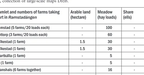
The calculation shows that ten of the 24 studied parishes produced hops exceeding the estimated aggregated household needs; Brod-detorp, Stenstorp, Östra Tunhem, Håkantorp, Friggeråker, Länghem and Dannike in Västergöt-land, Tjällmo in Östergötland. Västland and Tierp in Uppland are important hop producing regions, but are missing in the diagram (figure 2) because the land surveyors have not mentioned the number of poles.28 The most substantial hop
gardens were generally found among the medi-um-sized and large farmsteads. The size of the hop gardens varied regionally. In Västergötland the average garden in each parish comprised
figure 1. This photo shows how hop was, and still is, grown, on poles. Photo by Else-Marie Karlsson Strese.
figure 2. The diagram shows eight of the ten parishes (Västland and
Tierp parishes are missing because the surveyors did not register the number of poles) were the production of hops exceeds the aggregated estimated households’ needs among all the farmsteads in the parish. Each household needed approximately 40 to 100 hop poles. The hop production in Stenstorp parish was over 1 200 poles per farm in av-erage.
from 312 (Dannike) to 1 382 poles (Stenstorp) (see figure 2).
The concentrations of hop-growing farms on the maps obviously reveal two different catego-ries of producers, with two different kinds of economies; the self subsistence farm and the commercial farm.
The first category contains small farms like Sundsjö (figure 3), with one or a few acres of arable land, sometimes with a small hop-garden consisting of 50−100 poles. An amount enough for the household need only.
On the other hand, we see farms like
Hulje-sten (figure 4) or Maln (figure 5), with large arable fields as well as extensive hop-gardens. Huljesten’s acreage is over ten times larger than the previously mentioned farm, Sundsjö, and the hop-garden contains 8 000 poles, to compare with the 50 to 100 poles needed for the house-hold. I would say this is an economic speciali-zation with hop as a cash crop. Huljesten was mapped 1644, one hundred years, or about four generations of farmers, before the big changes, the ‘agricultural revolution’ started around 1750. The farm is situated within Stenstorp, the most important hop-producing parish in my study.
figure 3. Sundsjö, Nykyrka parish, Östergötland (D5:258-259, mapped 1635−1637). Sundsjö, with only 2 acres
of arable land, represent the small farms with a diversified economy, sometimes including a small hop garden for household needs. Sundsjös hop garden is illustrated with the number ‘8’ within a non coloured small area close to the farm.
figure 4. Huljesten, Stenstorp parish,
Västergöt-land (P2:96, mapped 1644−1647). Huljesten re-present the commercial farm, with large arable fields as well as a substantial hop garden, in this case 8 000 poles. The two hop gardens situated close to the farm buildings are illustrated with green colour and the letter ‘h’.
figure 5. Maln, Tierp parish, Uppland (detail
from A3:193, mapped 1640−1641 by Sven Måns-son) represent the hop-districts in northern Uppland. The surveyor did not mention the number of poles, but the hop gardens were five, and substantial. The hop gardens are shown as white areas filled with round symbols. They are situated close to the cultivated fields, but on the border between arable land and less fertile, non-cultivated, land.
The number of hop poles in Maln is not men-tioned by the land surveyor, but according to the size and number of the hop gardens belong-ing to this sbelong-ingle farmstead, the crop was essen-tial in the economy.
However, I see no signs among the 1 100 studied farms of the ‘modern’ form of speciali-zation that involves producing only one crop or product, and using the profit to buy daily neces-sities. I am well aware that this could have been the case in other regions. Subsistence farming was always the economic base among the stud-ied farms in Västergötland, Östergötland and Uppland. Not even the farms with hop gardens containing several thousand poles had less acre-age or hay than their non-hop-producing neigh-bours. This unwillingness to transfer arable land from grain or hay production to hop gardens in order to earn more money indicates, as I see it, family farmsteads that were run with a long-term view. The economy was built on a subsistence production, were grain and hay for household needs always was an important part. If possible, if the family could afford to transfer soil, man-power etc, the economy could be supplemented with a substantial hop garden. I interpret this behaviour as an answer to the prevailing insecu-rity about grain prices as well as supply of food for sale, changing taxes due to the war and the constant worry of crop failure.
The explanation of why some regions de-velop commercial hop-farming could of course be large regional demands from the growing towns, and the strong need for beer to provide for the comprehensive gathering of armed forc-es during this time of wars. However, this is not the answer; several corresponding regions with similar geographical conditions and in a similar vicinity to a town, do not show the same devel-opment. This may indicate that in some towns the inhabitants grew hops, or that imported hops were available in some regions. There were obviously not one, but several, explanations for why certain farmsteads, within certain regions, developed the studied activities on a scale that exceeded the household’s needs.
There seems to be three key factors that af-fect the social organization and make a
devel-opment towards commercial hop-farming pos-sible.
First, the geographical location. The hop-growers are never found in the best grain pro-ducing, fertile, regions, nor in the wooded areas, but in between. They are found in regions with a large environmental variety, where the farms have access to several different resources. This environment seems to be the “engine” in the process of agricultural specialization.29
Second. There is a long tradition in how the taxes and rents were paid. Eastern Sweden’s farmers mainly paid their duties in kind, espe-cially in grain. In western Sweden, money was to a larger extent used early for this purpose.30
To pay in grain, you have to produce enough for the household needs, and to pay the rents. You are extremely vulnerable to bad harvests and to changing grain-prices. And most, or all, of the farmsteads resources; work, soil, manure etc, must in this case be concentrated to the arable fields. In western Sweden, where the larg-est hop-producers were found, the duties were mainly paid in cash. How the money was raised was of course of no interest to the landowner or the Crown. This system opened opportunities to adapt the economy and gave the farmer some more freedom to use the available resources ef-ficiently.
And third, the highest degree of specialized hop-farms is found among the medium sized or larger farms. Not, as I assumed in my hypothe-sis, among the smaller farms. These larger farms obviously had enough manpower, enough ma-nure and the possibilities to transfer good soil from grain- to hop producing.
To sum up, and to try to identify a few impor-tant differences between the commercial and the self subsistence farm, I would say that the family with the commercial farm was probably reason-ably wealthy. In other words, they had enough arable fields and other important environmental resources to support the household without hav-ing to buy too much grain or hay. They could afford to spare some good soil for the plants, and to keep enough cattle to produce even more manure than needed for the grain fields. They also had the possibility to spare manpower and
time to tend to the demanding hops, a crop that took a lot of time to cultivate, to harvest and to dry. The families most likely paid a large part of their tax in cash, rather than in kind. This system gave them a larger economic freedom; the mon-ey could be raised in many different ways. The decision level was obviously on the family-, rath-er than the village level. This is illustrated by the fact that among the concentrations of commer-cial farmers, there are large differences between the neighbours in the same hamlet. One farmer might have a mill; while another neighbour has 2 000 hop poles, and a third none of this.
… and war
Why was there a need to sell cash crops? Why the need for money? As we have seen, it was not the smaller or poorer farms that took up large scale hop growing. Of course money was always needed to answer the Crowns growing demands in this time of wars. There was always an economic as well as human insecurity con-nected to the enlistment system, where adminis-trative units comprising a group of farmers were responsible for one soldier.31 The soldier was
usually a son from one of the families in each unit. This soldier could at anytime be injured or killed, and the unit then had to supply and arm another soldier to replace him. Another interest-ing and important reason for the need of cash is suggested by Nils Erik Villstrand: the possibility of hiring a soldier to avoid enlistment.32 There
were always poor men, willing to take the en-listed soldiers place if the payment was good enough. This (expensive) opportunity to keep sons from the war required the family to find a complementary source of income, in order to in-crease their savings, and encouraged the growth of new products for which there was market de-mand alongside the subsistence farming. In his study Villstrand shows that many seventeenth-century farmers in Österbotten (now a region in Finland, but belonged for a substantial time to Sweden) increased their productivity by produc-ing large amounts of tar. Tar was profitable; it was needed in the ship-industry. This allowed the farmers to pay the higher duties without
risking pauperization. Producing tar was also suitable because most Österbotten farmers had knowledge in tar-making, had access to wood-lands and the work could be performed during the farm-year’s calmer periods in the winter.33
Adapting to the new situation and the esca-lating economic pressure caused by the wars, by adding on a profitable cash crop − hops − for which there was market demand is, in my point of view, very reasonable. By this strategy the family could keep their grain fields, their animals and hay meadows for household needs, and still sell hops to increase their income. Hop is a demanding plant, but it could be cultivated in one or several enclosures in comfortable dis-tance to the farmstead, as the maps show, and be fertilized with household waste. If the farm-ers had the possibility to raise their productivity, their chances improved to survive the difficulties of the seventeenth century war economy with-out losing sons and husbands to enlistment, or without undermining their vulnerable economy. Maybe the women were the main hop farmers? The question need to be studied further, so far I can only argue that hop growing very well could be one of the Swedish farmers’ strategies to handle the changing demands from the Crown without risking impoverishment.
Hop farming in Sweden
This paper deals with the question if the large scale hop farms shown on the geometrical ca-dastral maps reflect an increasing specialization in cash crops as an answer to the escalating demands from the Crown during the time of wars.
My first hypothesis presupposed a division of work. The initial study showed that there was possibly a regional division of work, because the hop farms were unevenly distributed. But the presence itself does not show the proportions, which means that the hypotheses cannot be sup-ported without measuring the resources. After evaluating the produce of the farmsteads’ hop gardens, regions with specialist farmsteads be-come visible. Within these regions, the produce exceeds the estimated total household needs for
all the farms in the parish. As shown in figure 2, usually around 50 per cent of the farms in each of these parishes produced hops. However, I see no indication of farms exhibiting signs of the ‘modern’ form of specialization that involves producing only one crop or product, and using the profit to buy daily necessities. Not even the farms with hop gardens containing several thou-sand poles had less acreage or hay than their non-hop-producing neighbours. This indicates, as I see it, family farmsteads built on subsistence farming, if possible supplemented with a cash crop or other products to sell (tar, charcoal, fish or fruit).
In the second hypothesis I supposed that larger hop gardens were associated with the smaller (in acreage) farms. The thought behind this was that these households, for economic security reasons, developed other sources of in-come to be able to buy or barter the grain they needed for consumption and taxation, and to increase their savings − money could at any time be required to replace a soldier or his equip-ment. This assumption was proved incorrect. The hop farms were usually found among the medium-sized or large farmsteads. The small farmsteads probably had several other sources of income that are not shown on the maps, such as transportation, crafts, day labour etc. The larger, and probably relatively wealthier, farmsteads obviously had a better starting po-sition than the smaller ones, according to the results of this study. One possible explanation of Västergötland’s numerous and large hop gar-dens could be the tradition of how the taxes and rents were paid. In eastern Sweden (where Uppland and Östergötland are situated) peas-ants mainly paid their duties in kind, especially in grain. In western Sweden (Västergötland), money was used for this purpose to a larger ex-tent. To pay the duties in grain, it was necessary to produce enough for the household needs (in-cluding seed corn) and also to pay the rents. This means a great vulnerability to bad harvests and to changing grain-prices, and most, if not all, of the household’s resources such as human labour, manure, and time, must be concentrated on the arable fields.
There were obviously several explanations for why certain farmsteads, within certain re-gions, developed hop farming on a scale that exceeded the household’s needs. Some factors were, according this study, thoroughgoing, such as environmental resources and enough arable land to support the household without having to buy grain or hay. Other factors remain to be analysed, but some were probably of significant importance: the possibility to spare manpower and time on work beyond subsistence produc-tion; the possibility to spare some good soil for the plants (hop gardens and orchards); the pos-sibility to keep enough cattle to produce even more manure than needed for the grain fields (hop gardens and orchards); and the possibil-ity to pay substantial part of the taxes in cash, rather than in kind. This system meant greater economic freedom as the money could be raised in many different ways.
The question why, as in why the need for money and why take up time consuming large scale hop farming, can not be answered here, but discussed. I interpret this behaviour as an answer to the insecurity about prices as well as supply of food for sale, changing taxes due to the war and the constant worry of crop failure. Another important factor isstudied by Villstrand (1992a, 1992b, 1996a, 1996b): the possibility of hiring a soldier to avoid enlistment required money, and encouraged the growth of new products for which there was market demand alongside the subsistence farming.
pia nilsson is an agrarian historian and archae-ologist with the Swedish National Heritage Board. PhD in 2010 at SLU, the Swedish Uni-versity of Agricultural Sciences, Ultuna, with a thesis entitled (in Swedish) Beyond field and meadow. The occurrence and significance of mills, fishing, hop growing and fruit growing according to the earlier geometrical cadastral maps (c. 1630−1650).
pia.nilsson@raa.se
Riksantikvarieämbetet
Notes
1 Lindegren 1980, p. 11; Villstrand 1992a; Myrdal 1999, p. 228; Hallenberg 2001.
2 Brunius 1980, p. 12.
3 Villstrand 1996b, p. 62ff.; Stridsberg 1992.
4 Hannerberg 1971, p. 123; Myrdal & Söderberg 1991, p. 24.
5 Myrdal 1999, pp. 242, 255, 256, 297−302; Myrdal & Sö-derberg 1991, pp. 18−19; Larsson 1972, p. 149. 6 Hanssen 1952, p. 17; Gadd 1991, p. 20. 7 Andersson Palm 1991, p. 12; Gadd 1991, p. 65. 8 Myrdal 1999, p. 331.
9 Larsson 1972, p. 149; Myrdal & Söderberg 1991, pp. 18−19; Myrdal 1999, pp. 242, 255−256, 297−302. 10 Villstrand 1992a, pp. 24f.
11 Gadd 1991, p. 26. 12 Nilsson 2008, pp. 75−80.
13 Sveriges rikes lag 1734, Rättshistoriskt bibliotek 1984, p. 80; Holmbäck and Wessén 1962, p. 110f; Ahlberger 1988, p. 61; Wennersten & Sporrong 1995; Widgren 1995; Slotte 1999, p. 27.
14 Slicher van Bath 1963, pp. 134−135; Jansson 2005, pp. 47f.
15 Bergsten 1946. 16 Chayanov 1986.
17 Kardell 2004, pp. 25f.; Chayanov 1986; Flygare 1999; Liljewall 1999.
18 Israelsson 2005, pp. 262f. 19 Nilsson 2010.
20 Forssell 1939; Hedenstierna 1949; Göransson 1977; Vest-bö Franzén 2004, p. 49.
21 Styffe 1856, pp. 253−255; Bergsten 1946; Hedenstierna 1949; Helmfrid 1962; Vestbö Franzén 2004.
22 Nilsson 2010.
23 Karlsson Strese, Karsvall & Tollin 2010, p. 219. 24 The studied parishes are: Tierp, Västland, Rasbo,
Alun-da, Knutby, Färentuna, Sånga, Adelsö (Uppland), Tjäll-mo, Kristberg, Nykyrka, Vinnersta, Orlunda, Allhelgo-na, Fivelstad (Östergötland) and Dannike, Finnekumla, Länghem, Tunhem, Håkantorp, Stenstorp, Friggeråker, Broddetorp, Gudhem (Västergötland).
25 Morell 1987, p. 7; Karlsson Strese 2008a, pp. 46f.; Karls-son Strese 2008b, p. 89; KarlsKarls-son Strese & Tollin 2008, p. 34.
26 Schlyter, J.W., 1862, pp. 231−215; Sveriges Rikes lag. Rättshistoriskt bibliotek 37, 1984, p. 68
27 Karlsson Strese 2008a, p. 47.
28 The calculation is made from tax registers and by mea-suring the size of the hop gardens on the maps. 29 Bergsten 1946; Hanssen 1952; Jansson 1998; Larsson
2009.
30 Gadd 1991, pp. 216, 218.
31 The Swedish expression for this administrative unit is
rote.
32 Villstrand 1992a, 1992b, 1996a, 1996b 33 Villstrand 1992a, pp. 24f., 118−221, 165; 1999.
References
Unpublished maps
The National Archives, Stockholm
A3:193, Maln, Tierp parish, Uppland, 1640−1641.
D5:258-259, Sundsjö, Nykyrka parish, Östergötland, 1635− 1637.
P2:96, Huljesten, Stenstorp parish, Västergötland, 1644− 1647.
Bibliography
Ahlberger, Christer, 1988, Vävarfolket. Hemindustrin i Mark
1790−1850. Diss., Göteborgs universitet, Göteborg. Andersson Palm, Lennart, 1991, “Det starka
bondesamhäl-let. Sjuhäradsbygden 1434−1529”. Folkets historia No. 4, årgång 19, pp. 11−26.
Bergsten, Karl Erik, 1946, Östergötlands bergslag: en
geo-grafisk studie, Diss., Lunds universitet, Lund.
Brunius, Jan, 1980, Bondebygd i förändring. Bebyggelse och
befolkning i västra Närke ca 1300−1600, Diss., Lunds universitet, Lund.
Chayanov, A.V., 1986, The Theory of Peasant Economy. The University of Wisconsin Press, Madison. First published 1966 in USA, Homewood.
Flygare, Irene, 1999, Generation och kontinuitet:
familje-jordbruket i två svenska slättbygder under 1900-talet,
Diss., Sveriges lantbruksuniversitet, Uppsala.
Forssell, Einar, 1939, Kulturlandskapets utveckling i
Sollen-tuna från 1500-talet till i början av 1900-talet. En studie över en socken i Stockholmstrakten (Meddelande från
Geografiska institutet vid Stockholms högskola, 99-0876306-7; 50), Stockholms universitet, Stockholm, pp. 281−318.
Gadd, Carl Johan, 1991, Självhushåll eller arbetsdelning?
Svenskt lant- och stadshantverk ca 1400−1800 ( Medde-landen från ekonomisk-historiska institutionen vid Göte-borgs universitet 64), GöteGöte-borgs universitet, Göteborg. Göranson, Ulla, 1977, Kulturlandskapsförändring och
sam-hällsutveckling. En undersökning av rumsliga föränd-ringar av kulturlandskapet i Torstuna socken i Uppland från 0 till 1650, Diss., Stockholms universitet, Stockholm. Hallenberg, Mats, 2001, Kungen, fogdarna och riket.
Lokal-förvaltning och statsbyggande under tidig Vasatid,
Diss., Stockholms universitet, Stockholm.
Hannerberg, David, 1971, Svenskt agrarsamhälle under 1200 år. Gård och åker. Skörd och boskap.
Läromedelsför-laget, Stockholm.
Hanssen, Börje, 1952, Österlen. En studie över
socialantro-pologiska sammanhang under 1600- och 1700-talen i sydöstra Skåne, Diss., Stockholms Högskola,
Stock-holm.
Hedenstierna, Bertil, 1949, Stockholms skärgård.
Kulturgeo-grafiska undersökningar i Värmdö gamla skeppslag,
Diss., Stockholms universitet, Stockholm.
Helmfrid, Staffan, 1962, Östergötland Västanstång, Diss., Stockholms universitet, Stockholm.
nötkreaturs-skötsel och besättningsstorlekar på torp och herrgårdar 1850−1914, Diss., Sveriges lantbruksuniversitet, Uppsala. Holmbäck, Å. & Wessén, E., 1962, Magnus Erikssons
lands-lag i nusvensk tolkning, Rättshistoriskt bibliotek, sjätte
bandet. Nord. bokh., Stockholm.
Jansson, Ulf, 1998, Odlingssystem i Vänerområdet: en studie
av tidigmodernt jordbruk i Västsverige, Diss.,
Stock-holms universitet, Stockholm.
Jansson, Ulf, 2005, “Till salu några tunnor spannmål, några pund ost och smör. Odlingssystemens ekonomiska di-mension i östra Värmland”, in Jansson, U., Mårald, E. (eds.), Bruka, odla, hävda: odlingssystem och uthålligt
jordbruk under 400 år (Skogs- och lantbrukshistoriska
meddelanden 33), Kungl. Skogs- Lantbruksakademien, Stockholm, pp. 43−54.
Kardell, Örjan, 2004, Hägnadernas roll för jordbruket och
byalaget 1640−1900, Diss., Sveriges lantbruksuniversitet, Uppsala.
Karlsson Strese, Else-Marie, 2008a, “Humlegårdar på kar-tor, växter i naturen”, in Höglund, M. (ed.), 1600-talets jordbrukslandskap: en introduktion till de äldre geom-etriska kartorna, Riksarkivet, Stockholm, pp. 46−52.
Karlsson Strese, Else-Marie, 2008b, “Inventering av kul-turhumle”, in Eklund, L-E., Gräslund, A-S. & Svensson, B. (eds.), Kartan i forskningens tjänst (Acta Academiae Regiae Gustavi Adolphi 104), Kungl. Gustav Adolfs Akademien för svensk folkkultur, Uppsala, pp. 75−89. Karlsson Strese, Else-Marie & Tollin, Clas, 2008, “Humle
finns i öl av ‘fel’ skäl”, Forskning och Framsteg 3/08, pp. 30−35.
Karlsson Strese, Else-Marie, Karsvall, Olof & Tollin, Clas, “Inventory methods for finding historically cultivated hops (Humulus lupulus) in Sweden”, Genetic resources
and Crop Evolution 1−9, Volume 57, Issue 2 (2010),
p. 219.
Larsson, Jesper, 2009. Fäbodväsendet 1550−1920: ett centralt element i Nordsveriges jordbrukssystem, Diss., Sveriges
lantbruksuniversitet, Uppsala.
Larsson, Lars Olof, 1972, Kolonisation och
befolknings-utveckling i det svenska agrarsamhället 1500−1640,
Liber läromedel/Gleerup, Lund.
Liljewall, Britt (Ed.), 1999, Tjära, barkbröd och vildhonung, (Skrifter m skogs- och lantbrukshistoria 9), Nordiska museet, Stockholm, pp. 138−152.
Lindegren, Jan, 1980, Utskrivning och utsugning:
produk-tion och reprodukproduk-tion i Bygdeå 1620−1640, Diss., Upp-sala universitet, UppUpp-sala.
Morell, Mats, 1987, Studier i den svenska
sumtionens historia: hospitalshjonens livsmedelskon-sumtion 1621−1872, Diss., Uppsala universitet, Uppsala. Myrdal, Janken, 1999, Jordbruket under feodalismen
1000−1700 (Det svenska jordbrukets historia. 2), Natur och Kultur/LTs förlag, Stockholm.
Myrdal, Janken & Söderberg, Johan, 1991, Kontinuitetens
dynamik: agrar ekonomi i 1500-talets Sverige, Almqvist
& Wiksell International, Stockholm.
Nilsson, Pia, 2008, “Ett får för två lass hö − byte och hyra av resurser i 1600-talets jordbruk”, in Höglund, M. (ed.),
1600-talets jordbrukslandskap: en introduktion till de äldre geometriska kartorna, Riksarkivet, Stockholm,
pp. 75−80.
Nilsson, Pia, 2010, Bortom åker och äng. Förekomst och
betydelse av kvarnar, fiske, humle- och fruktodlingar enligt de äldre geometriska kartorna (ca 1630−1650),
Diss., Sveriges lantbruksuniversitet, Uppsala.
Schlyter, D.C.J. (ed./publisher), 1862, Samling av
Sweri-ges gamla lagar, på kongl. Maj:ts nådigste befallning utgifven af C.J. Schlyter. Vol. 10. Konung Magnus Erikssons landslag, Berlingska boktryckeriet, Lund.
Slicher van Bath, B.H., 1966, The Agrarian History of
West-ern Europe A.D. 500−1850, reprint 1963, London. Slotte, Håkan, 1999, Lövtäkt i Sverige 1850−1950. Metoder
för täkt, torkning och utfodring med löv samt täktens påverkan på landskapet (Serie: Agrarhistoria 2), Inst.
för landskapsplanering Ultuna, Uppsala.
Stridsberg, Einar, 1992, Hållnäsbygden under
kolskogsepo-ken 1626−1926, Diss., Kulturgeografiska institutionen, Stockholms universitet, Stockholm.
Styffe, Carl Gustaf, 1856, Samling av instructioner rörande
den civila förvaltningen i Sverige och Finland, Hörberg,
Stockholm.
Sveriges rikes lag. Gillad och Antagen på Riksdagen åhr 1734, 1984 (Skrifter utgivna av Inst. för rättshistorisk forskning. Serie 1. Rättshistoriskt bibliotek, trettiosjunde bandet), Inst. för rättshistorisk forskning, Stockholm. Wennersten, Elisabeth & Sporrong, Ulf, 1995, Leksands
sockenbeskrivning. D 10. Marken, gården, släkten och arvet: om jordägandet och dess konsekvenser för människor, landskap och bebyggelse i Tibble och Ullvi byar, Leksands socken 1734−1820. Kommunen: Leksand (Meddelande B 91), Kulturgeografiska institutionen, Stockholms universitet.
Vestbö Franzén, Ådel, 2004, Råg och rön: om mat,
män-niskor och landskapsförändringar i norra Småland, ca 1550−1700, Diss., Stockholms universitet, Stockholm. Widgren, Mats, 1995, “Individuellt eller kollektivt ägande i
bondesamhällen?”, in Widgren, M. (ed.), Äganderätten
i lantbrukets historia (Skrifter om skogs- och
lantbruks-historia 8), Nordiska museet, Stockholm, pp. 5−16. Villstrand, Nils Erik, 1992a, Anpassning eller protest:
lokalsamhället inför utskrivningarna av fotfolk till den svenska krigsmakten 1620−1679, Diss., Åbo Akademi, Åbo.
Villstrand, Nils Erik, 1992b, “Med stor möda i en hop gropar i marken: tjärbränning kring Bottniska viken un-der svensk stormaktstid”, Historisk tidskrift för Finland, 1992 (77), pp. 31−72.
Villstrand Nils Erik, 1996a, “Bonderusthållarna som socialt avantgarde”, Historisk tidskrift för Finland, 1996 (116), pp. 563−571.
Villstrand, Nils Erik, 1996b, “En räddande eld: tjärbränning inom det svenska riket 1500-1800”, in Liljewall, B. (ed.),
Tjära, barkbröd och vildhonung (Skrifter om skogs- och
lantbrukshistoria 9), Nordiska muséet, Stockholm, pp. 62−75.
Villstrand, Nils Erik, 1999, “Ett avlägset krigs närhet. Trettioåriga kriget och Sveriges östra rikshalva”, in Abukhanfusa, K. (ed.), Mare Nostrum (Skrifter utgivna av Riksarkivet 13), Riksarkivet, Stockholm.
Keywords: Agricultural specialization, Seventeenth century, Thirty Years War, Geometrical cadastral maps, Hop farming
Maps, hops and war
by Pia Nilsson
Summary
Regional specialisation is already identifiable in the 16th century, perhaps earlier still, but the breakthrough of commercial specialisation in the Swedish countryside is associated with the onset of the agrarian revolution in about 1750. This technical complex included new crops, livestock breeds, crop sequences, fertilisers and implements. The present article shows that studies of the earlier geometrical cadastral maps (1630−1655) reveal advanced large-scale hop farm-ing in certain regions and types of farmstead even a hundred years earlier. The information recorded by surveyors indicates two categories of hop-growing farmstead, one operating on a subsistence basis and the other commercially (cf. figs 3 and 4).
Regional demand from swelling towns and cities and the need of beer for the troops ac-count for the development of commercial hop farming in certain regions, but this is not the whole answer: not all regions with similar geo-graphic conditions and equidistant from a town or city present this development. The specialised farmsteads were mainly located within the well-resourced central region, and the most extensive hopyards of all were on the bigger farmsteads in
acreage terms; cf. figs 3−5). Subsistence produc-tion was always at the base of things, and obvi-ously the large-scale growers had enough arable land and other necessary resources to meet their domestic needs, added to which, they could af-ford to run enough livestock to cover the ferti-lisation requirements of both arable fields and hopyards. They also had time to spare, suitable soil and, not least, manpower for other tasks than tilling fields and tending livestock.
But why did one need to sell produce if not to make up for a deficiency, such as a short-age of arable land? What was the money needed for? The Thirty Years War was in progress and taxation was heavy. Then again, the “rote” sys-tem meant that families could any moment be required to replace a casualty or his equipment. A reserve of ready cash was imperative. Further and deeper studies are needed, but one possi-ble interpretation is that large-scale hop farm-ing was one way (among several) of copfarm-ing with the changed conditions following in the train of Sweden’s great-power aspirations, by increasing or diversifying output so as to generate financial margins.
his study is a part of a research project that deals with so-called utjordar and the problem of tracing deserted farms fol-lowed by the ‘Crisis’ of the Late Middle Ages. The late medieval decline is well observed in Europe and the Scandinavian countries although the consequences of the crisis have been much debated.1 A well-known consequence is deserted
settlement units, still present in the landscape in some locations. By the mid-fifteenth century a recovery can be observed but not all abandoned farms were resettled. Instead, a considerable number of deserted farms were taken over and cultivated by surrounding farms, sometimes con-verted into grass used for pasture or meadow. In Sweden this procedure is well documented in the Vadstena Abbey registers from 1447 to 1502.2 The details on farm level in Sweden,
how-ever, typically first appear in the sixteenth-cen-tury cadastral registers, the early national taxa-tion registers of farms.3 In this source deserted
farms appear as uninhabited units referred to as utjord (pl. utjordar). Furthermore, utjord has an ambiguous meaning in the registers, as it also refers to assorted pieces of land, for instance land donated to the church.4 Hence, it has been
questioned whether utjordar generally are a fea-sible indicator of desertion or not.5 So far the
phenomenon of utjordar has rarely been stud-ied, however, which motivates further research.
This paper aims to discuss the characteristics of utjordar in two sources: the cadastral registers dating from the 1540s and the large-scale maps dating from the 1630s. It focuses on whether utjordar are constant or fluctuating in the
six-teenth- and sevensix-teenth-century. An assumption is made that the chronological depth of utjordar reflects a late-medieval origin. For example, if an utjord is preserved, and appears in records of the 1540s and 1640s, it is likely to originate from a late-medieval or older practice.6 The text
follows two steps. First, on a national level all occurrences of utjordar in the large-scale maps from 1630 to 1655 are compiled by means of a recently published database.7 Second, a single
parish is chosen for a close study comparing in-dividual utjordar in cadastral records, large-scale maps and also younger maps, using a retrogres-sive approach.8 Nevertheless, having its focus on
utjordar and the possibility to identify deserted farms, this text does not draw further conclu-sions on the Crisis of the Late Middle Ages and the Black Death aftermaths.
The possibility of describing the character-istics of utjordar has recently increased since about 12,000 Swedish large-scale maps dating from 1630 to 1655 have been published with text transcriptions and a coordinate-based data-base on the Internet. These maps are the oldest source for describing utjordar as they appear in the landscape. Together with the map’s text descriptions, Notarum Explicatio, the maps en-able analysis by means of several criteria. The following criteria have been considered:
1) The total size of arable land and meadow. 2) The land ownership by social category;
Free-hold peasantry, the Crown and the Nobil-ity.9
3) The pattern of contact between an utjord
Utjordar and the question of deserted
farms − a case study of the parish of
Svanshals
by Olof Karsvall
and a farm, for instance if one utjord be-longs to one or several farms and vice versa. 4) If utjordar have their own names, place
names or field names.
The parish of Svanshals was chosen for the case study. It is located in Tåkernbygden, south of Lake Tåkern, in the province of Östergötland. Utjordar were a common element in this region in the sixteenth and seventeenth century and are typically situated within the older hamlets.10 The
various characteristics of utjordar in this area were first analysed by geographer Staffan Helm-frid, and this parish of Svanshals is therefore suitable for a further comparison of the results.11
Another reason for choosing a parish located on the plains is because of the settlement units and boundaries in this part of Östergötland have long continuity. As discussed by geographer Clas Tollin, the seventeenth-century large-scale maps add few new hamlets, farms or lands for cultivation compared with the medieval pre-Black Death situation.12 The maps are therefore
suitable sources for the agrarian landscape of the Late Middle Ages.
Farm desertion in Sweden
The ‘Crisis’ of the Late Middle Ages in Sweden has probably been underestimated for a long time. According to agrarian historian Janken Myrdal, Sweden follows the trend seen in sev-eral European countries, ending with economic growth and expansion of arable land during the first half of the fourteenth century and starting with a general decline during the Late Middle Ages.Several major outbreaks of plagues in Swe-den have been documented during the 1350s, 1360s and early fifteenth century and a depopu-lation of around half the popudepopu-lation has been suggested by Myrdal.13
The pestilences are an obvious reason for not only increasing mortality but also farm deser-tion. The extent of farm desertion in Sweden, however, is still very unclear and gives rise to dif-ferent assumptions. Deserted farms were studied by the Scandinavian joint project in the 1970s and 1980s. The project gained inspiration from
the previous studies of deserted settlements in England and Germany.14 The Swedish group
provided six regional studies and a minor level of desertion was observed with one exception. In contrast the Norwegian studies presented the opposite trend, with a high level of farm deser-tion.15 The very disparate results were attributed
to regional differences but were also criticized for being a consequence of two different meth-odological approaches. The Swedish group was probably too focused on explicit evidence of de-sertion and consequently only a minor level of all deserted farms during the Late Middle Ages were observed.16 A high level of deserted farms
in the Vadstena Abbey registers of 1447 corre-spond to more recent observations made in the provinces of Värmland and the later Swedish provinces of Jämtland and Bohuslän, although desertion is a social process and not all regions were affected equally.17 A common
understand-ing is that northern Sweden, for instance the provinces of Hälsingland and Västerbotten, were not affected by a similar desertion.18 Moreover,
the allocation of deserted farms in the most populated areas in central Sweden, the provinc-es of Uppland, Östergötland and Västergötland is not well studied.
One reason why the level of desertion could be underestimated is because of hamlets in populated regions seldom totally disappear but rather shrink. Few works, however, relate to the changing agrarian structures, followed by increased mortality and farm desertion. The typical deserted farm is an isolated farm in a rather fringe remote location.19 Understandably
the contraction of the arable land, followed by a great decline, started in the remote areas rather than in hamlets on fertile plains.20 There are
ex-amples in the records where the arable land was converted into grass, used for grazing, meadow or pasture by other farms. Some of these loca-tions could still be traced by remaining field patterns in the landscape or by preserved place names.21 Partial desertion or desertion within
hamlets, on the other hand, is not as recogniz-able as a total destruction of settlements. Pri-marily smaller hamlets (2-5 farms) characterized the medieval Sweden. An abandoned farm in