ACCESS AND USE OF ET DATA ON THE INTERNET Kenneth G. Hubbard
University of Nebraska Lincoln, Nebraska
ABSTRACT. The High Plains Oimate Center (HPCQ was established in 1987 and is one of six centers providing coverage of the continental U.S. HPCC is located at the University of Nebraska in Lincoln. HPCC's mission is to carry out applied climate studies to aid in the development of improved climate products for use in an array of climate services, including data collection, analysis, and dissemination in the HPCC region. This paper describes the Automated Weather Data Network (AWDN) and the interfaces that provide near real time climate services with emphasis on ET or crop water use. Automated weather stations are monitored daily at 139 locations in ten states. Data are subjected to quality assurance testing and made available to the public. AWDN data are merged with a stream of data that includes the cooperative network data and historical data dating to the 1800's. Queries by the public to the subscription based On-line interactive system have reached 6000-7000 per month while queries to the HPCC home page average 15-20K per month.
1.0 INTRODUCTION
Regional Climate Centers (RCCs) have been established in response to the need to improve climate services at the local, state, and regional levels (Changnon et al., 1990). One of the fundamental challenges for RCCs is to advance the provision of climate information for the nation's economic, governmental, and social sectors.
Several major requirements must be addressed in order to improve climate services. One requirement is an adequate data collection system in terms of number of variables measured, sampling frequency, and timeliness of data transferal and 「eceipt A second requirement is the need for sufficient quality control and analyses P「ocedures. This requirement demands that accurate data be available for use in summaries and products and that the content of these be keyed to the needs of decision makers and resource managers in the targeted sector of the economy. In many cases, applied research is needed to develop models and other technological tools for the purpose of relating the current climate situation to the area of interest (agriculture, water resources, energy, transportation, 「ecreation, etc.). Another 「equirement is adequate technology to deliver the summaries and products in a timely manner.
The use of electronic equipment to automate the collection of measurements from weather-related sensors at remote sites has brought about a change in the ability to collect weather data (Hubbard et al., 1983). This advance in the field of data collection has found its way into the National Weather Service program of modernization, as more than 1000 ASOS (Automated Surface Observing System) weather stations were installed over the past decade (ASOS, 1988). Automated state and private networks also were initiated and a survey determined that these networks are comprised of more than 600 weather stations.
Communication and computer technology have greatly increased the ability of climatologists to monitor and disseminate the important characteristics of climate. RCCs are institutions that engage in such applied research as is necessary to improve climate products including crop water use estimates.
2.0 DATA COLLECTION
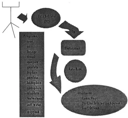
Automated weather stations are maintained at 139 locations in the ten-state region (CO, IA, KS, MT, MN, MO, ND, NE, SD, and WY). These stations collect hourly data for variables known to be of importance to agricultural crop and livestock production, including air temperature and humidity, soil temperature, precipitation, wind speed and direction, and solar radiation. A computer calls each station beginning at 1 A.M. The data for the previous 24 hours is downloaded, quality controlled, and archived for use by the HPCC system. A flow diagram is shown in Fig. 1. Software and system components have been documented for this system (Hubbard et al., 1990).
Weather stations at remote sites monitor sensors every 10 secs and calculate the hourly averages and where appropriate totals. The minimum set of sensors is shown in Table 1.
The installation heights shown are standard for AWDN stations. Other 「ecommendationsfor standards have been put forth by the World Meteorological Organization, the United Kingdom Meteorological Office and the National Weather Service. For these standards and those of other Automated Weather Networks in
the U.S. see Meyer and Hubbard (1992).
Growth of the AWDN was fairly rapid (see Table 2). Much of the initial growth was due to the interest of researchers who were operating digital weather stations without the benefits of telecommunication or a data management system. In 1983, the AWDN began to grow into surrounding states. As time passed private sector interests offered to add stations. Resource management agencies also have taken an active role in addition and support of stations in the network. One unique
class of weather station sponsor is the community consortium. In this case a number of interested parties from a community (eg. agri-chemical dealers, farm elevators, radio station, public power agency etc.) agree to share in the expense of purchasing and maintaining a station.
Fig. 1. The flow of data through the automated weather network
Currently the 139 stations in the Network are distributed in the region represented by the High Plains Climate Center as follows: Colorado 4, Iowa 10, Kansas 16, Missouri 2, Minnesota 5, Montana 2, Nebraska 47, North Dakota 42, South Dakota 10, and Wyoming 1. The station locations are plotted in Fig. 2. In general, each state is responsible for maintaining i「sweather stations and the states with larger numbers of stations run a near-real time network to serve clientele within it's boundaries. The High Plains Climate Center calls these stations once each day in the early morning hours to download data.
An abbreviated maintenance checklist is given in Table 3. Replacement of sensor components includes bearings in the cup anemometer on a 2 year cycle. Relative humidity sensors are calibrated on an annual cycle. The potentiometer on the wind vane is replaced as needed. The tipping bucket is checked for level and
D D D D 口 □ □ D □ □ 口 □ D □ D □ □ □ 口 D D 口 D 口 □ E> D D D D □ D D
。二。
日 □ □ 目 D □ D D D □B
D D \ D 曰 d □ 口 。D \ D □ □1 □
D 口□□ oc:P°
D □ 圉 D D D D □ D D 口 DI □ D D D仁] D 口 □ □ □。°
D □Fig. 2 Location of stations in the Automated Weather Data Network.
calibrated each year by using the volume to mass relationship for a known amount of water. Leveling screws are adjusted if needed in order to obtain the correct number of tips. The wind vane can be tested by simply using a sightable compass and magnetic correction to determine true north. The vane is calibrated so that for example a complete turn produces a range of values from 0° to 358° for a
potentiometer with a 2 ° dead band. Certain sensors are removed from service for
calibration. The silicon cell pyranometers are calibrated as a group against an
Eppley Precision Spectral Pyranometer (Aceves-Navarro et al., 1989). In a similar
manner anemometers can be calibrated against a "secondary standard." Thermistors and humidity sensors can be calibrated directly under controlled conditions. Devices like dry block calibrators and dew point generators are useful
for this purpose.
Average annual costs associated with the network include: local telephone service ($480), telephone calls ($180), travel ($200), repair costs ($100), replacement costs ($100), and labor ($1,250). The total costs here is $2,310 per year but this cost does vary with the number of stations that are operating and other local rates.
3.0 DATA MANAGMENT AND APPLICATIONS PROGRAMS
A tremendous amount of data can be generated with an hourly weather network. In the High Plains case about 1 Mb of data is produced annually for any three stations. If this data is to be used effectively it must be easy to access. Thus, data management is a real concern. In the case of the High Plains network, the approach has been to develop a data management system written entirely in FORTRAN (Hubbard et al., 1992). This system is indicated as the data base component in Fig. 1.
A suite of utility programs includes tools for data management, quality control, data retrieval, and station selection. Applications software includes programs (see Fig. 1) to analyze data and produce summaries for any variable over any desired time period. Summaries include temperature, precipitation, heating and cooling degree days, growing degree days evapotranspiration, leaf wetness, soil water, and crop yield.
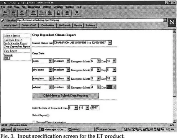
On the HPCC internet site for on-line subscribers a crop water use report may be generated by selecting inputs from the screen depicted in Fig. 3. The user is able to choose any combination of crops, maturity groups, and emergence dates. An example of the ET product is shown as in would appear on the computer screen (see Fig. 4).
4.0 RESEARCH NETWORK
The High Plains Automated Weather Data Network has served as a source of data for both research and service efforts. Some of the research aspects will be covered in this section and the service aspects will be covered in the following section.
Evaporation (ET) at the earth's surface is a major component of the hydrological cycle and is critical to irrigation scheduling from a water balance
羞5亞為紐燕二二二°`` D..曰七mtO転已e`..a
~
I
三-。立戶
;;切啊.。.,店?, 涵矼尹紅.「``!心這严m 叫m心心.NE5/19/1981to12/1O/1997J
疣蔥笠.芒.丑-胚至 一·一-·一·- .一 箜.'f,.`面1 l面這tin 出 lm正m 日巳,元eMo4 五呀「卫l l .... 9hum 囯 lm祉~~•M•洫 F7日 D"區7日~I.m訕um d 丘面心eMontb 「Ta 。"1113
E尊言這亨'"',,這..""一 J.,.',.. ````. -...```````````````'...`-`.`',巴``.````·'?`````·.',``````````....._.....``巴,````````````',```.````.. Eottr 耐•D,,. of Re心st<d D... 互斥桓: F
三一:Z,(.一',
3
证戶.
三``
`宰·;鱀睪鑒露雛藎謳霑芒螟翌忥蕊霑瞟蔡鍔盞鎏鱀矚;薰後; SdmI 玲0n(') 鉅盂姿[多同電圖_-谨禁·;Fig. 3. Input specification screen for the ET product.
approach. Research in the area of evapotranspiration has included efforts to identify the effect of random and systematic errors in measurements used to calculate potential ET (Meyer et al., 1989) as well as efforts to improve the
projectio頂 ofp啤ntial ET (Meyer, et al. 1988). The AWDN has also been essential
to de缸nnining appropriate limits fo「 po缸ntialET in the very arid parts of the High
Plains region (Hubbard, 1992).
Monitoring of drought conditions is another research focal point. Robinson
and Hubbard (1990) evaluated the potential use of network data in the assessment of soil water for various crops grown in the High Plains. A Crop Specific Drought
Index (C:SDI) for com has been developed and tested (Meyer, et al. 1992a). Results from the studies indicate that the CSDI for corn will be valuable when applied to drought assessment (Meyer, et al., 1992b). A CSDI for sorghum (Paes de Camargo, 1992) is also under development.
Accuracy of interpolation between stations in a network is also a topic of
「esearch. The spatial interpolation of potential ET (Harcum and Loftis, 1987) was
examined using AWDN data. On a related topic, the AWDN data were used to examine spatial variability of weather data in the High Plains (Hubbard, 1994). Another study examined whether it is better to interpolate the weather variables for
12I10/1', C良O'U矗T三R UZE `UllllA`
`
Im```, 。m U15I1'
,
IC•..e`
`
'Clum1···c1y, 2 一.畫di·`' - l·t.'一一一一,.C一---一·I·-```電-•I
,_`"'UCm曰na:Ii:I3d."'ld` `伍,這 lweltl---` ``是一~一一I
I一一·`.C1O11一一 1``',.-- "0山'dI-coo一1一一--"``璸 m` °'~--·I 一一一Dm..```一IICI CllllP1O日 CO「直 s 15 400, o.os 0.01 o.oe o.oe o. 10 ue量veo 1 2 cIWIP``
`"
b··2. S S S21.o.OSIO. 4O0. 11 0.``
` ` ` ; .2 2C曰UO``色 E0b口$ 1B 35O. o.os o.o` °·O6 O.°` °.o7 3 I..v·· 1
CIWIP``電··壘 1 1148. 0.17 0.)0 0.JO o.JO O.lP Flo,rerl 正g 2
`u 缸L` 50`1,..C0 血 1`c
霆璽霫漆璽響言璽霨雹酆霨霎霏尸雪量),直翌
瞬盆薳.. 量順]
Fig. 4. Format of the ET product from the On-line System
computing potential ET at a site or to interpolate the potential ET calculated at the surrounding stations (Ashraf, et al., 1992).
The AWDN system has been used to collect basic meteorological d~ta for various field experiments (eg. Hubbard, et al., 1988). Data taken by the system are also being used in urban water use studies and in project Storm.
5.0 SERVICE NETWORK
~ The HPCC staff developed an On-Line Internet system for
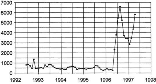
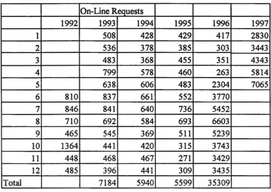
users which features interactive use of the entire historical archive of the HPCC. A revised system was released on May 1, 1996 and users of the former RBBS were invited to subscribe to the new system. Access to the new system jumped from approximately 2,000 to 6,000 per month in the initial six month period of operation. This is an sizeable increase as can be seen in Table 4 and Figure 5.
7000 6000 5000 4000 3000 2000 1000
。
1992'
·`l\ ,」`
1993---.
-`
一,一 丶 1994 1995 1996 - I\ I \ T`
I,
`
'「
I
.
' 1997Fig. 5. The requests for climate data handled by the HPCC On-line System.
1998
Digital data disseminated by the HPCC from the new system can be
「edistributedseveral times to larger audiences. A clear example is Data Translation Network (DTN). DTN, a private company, accesses HPCC's evapotranspiration, soil temperature, heating degree data and other reports which they broadcast to a network of subscribers. Paid subscribers to DTN are able to view this current information on their 1V screen. They choose the pages they wish to view by simply indicating an index number on a push button pad supplied by DTN. There are more than 100,.000 clients who subscribe to DTN.
On-Line Access System
The new On-line System offers both opportunities and challenges. The positive features of the system are:
• accessible by dial-up through direct modem connection or by using Telnet on the Internet
• the new system offers the computing power of a work station.
• clientele have on-line access to the historical data archives that date to the late 1800's.
• up-to-date data is available for decision makers who require it
• an autopilot feature allows users to schedule future summaries, saving the
time otherwise required to logon and re-create the summary
• automated information delivery by email or ftp
The additional features and power of the new system have led to increaased use by the HPCC clientele. However, improvements are underway including:
• greater simplicity of interface
• decreased learning curve
• navigation by'mouse'point-and-click
• new products for the system
The HPCC has formed a committee to look into the redesign of the On-Line system and the possibility of combining it with the HPCC home page.
Home Page
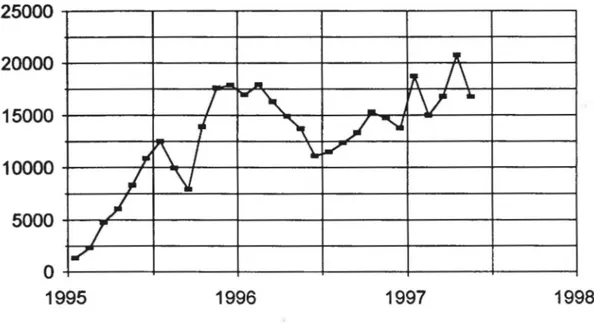
The HPCC home page committee designed a new home page (http://hpccsun.unl.edu). The number of accesses to the home page are shown in Fig. 6 and Table 6.
,. 25000 20000 15000 10000 5000
,I
f
,
。
1995'
」 'II'-
-
`
/ \
/
l一丶
-
v·
f
丶
J 丶「\丨
L
z
\L
1996 1997 1998Fig. 6. The number of hits on the HPCC Home Page, http:/ /hpccsun.unl.edu/
Table 1. Sensor installation, accuracy and sampling information.
Sensor Variable Installation Accuracy Hourly
HL
Thermistor Air temperature 1.Sm 0.25C Avg.(C)
Thermistor Soil temperature -10 cm 0.25C Avg.(C)
Si Cell Radiation-Global 2m 2% Flux
Pyranometer (Wm-2)
Cup Wind speed 3m 5%(0.Sm/s Total
Anemometer start-up) Passage
(ms-1)
Wind Vane Wind direction 3m 20 Vector
Direction
Coated Circuit Relative humidity 1.5m 5% Avg.(%)
Tipping Precipitation 0.5 to 1 m 5% Total (mm)
Table 2. Number of AWDN stations.
Number of Stations in AWDN by Year
1981 5 1989 74 1997 139 1982 14 1990 83 1983 21 1991 93 1984 29 1992 95 1985 47 1993 112 1986 51 1994 119 1987 49 1995 132 1988 60 1996 137
Table 3. Maintenance checklist Check sensor readings (daily) Clipping of vegetation (as needed) Onsite testing (4-6 months)
Cleaning of sensors (as needed)
Calibration of tipping bucket (annual) Calibration of solar sensors (annual)
Test and calibration of humidity sensor (annual) Replace bearings in anemometer (two years)
Replace potentiometer in wind vane (two-three years)
Table 4. Monthly Accesses to the HPCC On-line Service. On-LineR叩uests 1992 1993 1994 1995 1996 1997 I 508 428 429 417 2830 2 536 378 385 303 3443 3 483 368 455 351 4343 4 799 578 460 263 5814 5 638 606 483 2304 7065 6 810 837 661 552 3770 7 846 841 640 736 5452 8 710 692 584 693 6603 9 465 545 369 5 1 1 5239 10 1364 441 420 315 3743 11 448 468 467 271 3429 12 485 396 441 309 3435 Total 7184 5940 5599 35309
Table 5. Origin of self service requests by sector, October 1996-April 1997
Sector (%) Sector (%)
A~ricul. & F orestrv 12 Legal
。
Construction <1 Manufacturing
。
Consulting 4 Media <I
Education 75 Recreation
。
Energy <1 Retailing & Service
。
Engineering <1 Transportation 2
Government 6
Table 6. Monthly accesses to the HPCC Home Page. HomePage Hits Month 1995 1996 1997 1 1347 16973 18734 2 2330 17949 14993 3 4747 16295 16771 4 6055 14901 20733 5 8320 13718 16757 6 10890 11142 7 12524 11518 8 9963 12372 9 7925 13325 10 13909 15298 11 17600 14729 12 17904 13775 total 113514 171995 REFERENCES
Aceves-Navarro, L.A., KG. Hubbard, and J.J. Schmidt 1989. Group calibration of silicon cell pyranometers for use in an automated network. J. Atmos. and Oceanic Tech. 6(5):875-879.
Ashraf, M., J.C. Loftis, and KG. Hubbard. 1992. Application of geostatistics to evaluate partial weather station networks. Ag and Forest Met 84:255-271. ASOS. 1988. AS0'3 Progress Report June, 1988. National Weather Service. Silver Spring, MD.
Camargo, M.P. and KG. Hubbard. 1994. Test of soil water assessment model for a sorghum crop under different irrigation treatments. Bragantia. 53:95-105. Changnon, S.A., P.J. Lamb, and KG. Hubbard. 1990. Regional Climate Centers: New institutions for climate services and climate-impact research. Bull. American Meteorol. Soc. 71:(4) 527-537.
Harcum, J.B. and J.C. Loftis. 1987. Spatial interpolation of Penman evapotranspiration. Transactions of the ASAE, 30(1):129-136.
Howell T.A., D.W. Mack, C.J. Phene, KR. Davis, and R.L. McCormick. 1984. Automated weather data collection for research in irrigation scheduling. Trans ASAE 27(2):386-391
Hubbard, K.G., A. Bauer, B.L. Blad, J.L. Hatfield, E.T. Kanemasu, D.J. Major, R.J. Reginato and S. B. Verma. 1988. Monitoring the weather at five winter wheat experimental field sites. Agric. Meteorol. 44(2):117-130.
Hubbard, K.G. 1992. Climatic factors that limit daily evapotranspiration in sorghum. Climate Research. 2:(3).
Hubbard, KG., J.R. Hines, and D.A. Wood. 1992. Manual for installing and using the AWDN system software. High Plains Climate Center Report 92-2. University of Nebraska. 43pp.
Hubbard, KG., N.J. Rosenberg, and D.C. Nielsen. 1983. Automated weather data network for agriculture. J. Water Resources Planning and Management
109:(3)213-222.
Hubbard, KG. 1994. Spatial variability of daily variables in the high plains of the USA. Ag. And Forest Meteorology. 68:29-41.
Meyer S.J., KG. Hubbard, and D.A. Wilhite. 1989. Estimating potential evapotranspiration: the effect of random and systematic errors. Ag and Forest Meteorology 46:285-296
Robinson, J.M. and KG. Hubbard. 1990. Soil water assessment model for several crops in the High Plains. Agron. J. 82(6):1141-1148.
Tanner, B.D. 1990. Automated weather stations. Chap 6 in Remote Sensing Reviews, Gordon and Breach Science Publishers, New York NY. 360 pp.