A CASE STUDY OF USING IRAP MODEL TO IMPROVE
NON-MOTORISED TRANSPORT IN TIANJIN, CHINA
HU Han
Research Institute of Highway Ministry of Transport China No.8 Xitucheng Road, Haidian District, Beijing 100088
Tel:+861082019646 Email: h.hu@rioh.cn
Greg Smith, iRAP, greg.smith@irap.org; ZHANG Tiejun,Research Institute of Highway Ministry of Transport China, tj.zhang@rioh.cn.
ABSTRACT
This paper introduces a case study of using iRAP (International Road Assessment Programme) method to improve road safety of non-motorised transport in Tianjin, China. Based on the field survey results on the roads, the author calculated the current the star rating risks for different road users. Roads were screened by the star ratings and key road safety issues were identified. Corresponding countermeasures were selected controlled by economic indices. Number of fatal injuries and fatalities saved if the countermeasures adopted also provides the policy makers and design institute quantitatively in improving the designs and planning strategy. This is the first time that the international risk assessment model is used in China to improve non-motorised transport and it will provide experiences of risk assessment to other developing countries.
1. INTRODUCTION
Road crashes are one of the top three causes of death for people aged between 5 and 44 years of age worldwide. According to the World Health Organisation, 1.24 million people were killed on the world’s roads in 2010. This is unacceptably high. Road traffic injuries take an enormous toll on individuals and communities as well as on national economies. Middle-income countries, which are motorizing rapidly, are the hardest hit.
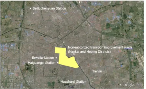
The Tianjin Urban Transport Project is a World Bank-financed project being undertaken by the city of Tianjin, China. The overall concept for the project is to reprioritize the use of active transport modes like walking or biking in combination with public transport to provide safe, clean and affordable accessibility and mobility solutions for Tianjin residents and to create a vibrant urban space and higher quality environment in the central part of the city. The study are is shown in Figure 1.
Figure 1: Study Area Road Map
This paper focuses on a Non-Motorised Transport (NMT) improvement component of the project. This NMT component is seeking to systematically reduce road safety hazards and existing bottlenecks for NMT, while maintaining mobility for all, including the less mobile. The streets will be repaved with safety facilities including bollards separating NMT from vehicles, pedestrian crossing facilities,
bus stops and junction improvements. This paper describes ChinaRAP assessments of the existing roads and the proposed additional improving opportunities for local authorities and designers.
The ChinaRAP team at the Research Institute of Highway (RIOH), Ministry of Transport, was engaged to lead the road safety component of the project preparation phase. ChinaRAP is led by RIOH in partnership with the International Road Assessment Programme (iRAP). The project is in part designed to demonstrate the impact of rigorous and data driven road safety assessment and design practices to reduce crash rates and provide a model that can be replicated in other provinces as well as in other developing countries.
2. STUDY METHODOLOGY
For safe road infrastructure improvements, there are many guiding methods, such as safety audits, accident analysis, safety assessment and black spot identification. The method of ChinaRAP safety assessment involves Star Ratings and Safer Roads Investment Plans which are based on systematic inspections of road infrastructure. The method draws the iRAP methodology and techniques developed by RIOH. More information about the iRAP (ChinaRAP) methodology is available at http://www.irap.org/en/about-irap-3/methodology.
ChinaRAP Star Ratings involve an inspection of road infrastructure attributes and the traffic operation condition that are known to have an impact on the likelihood of a crash and its severity. The method involves recording more than 50 road attributes at 100 metre intervals along a road. It is a tool to measure the safety level in an easy and objective way on the basis of the careful investigation on actual basic data of roads is provided in the project, and five star rating is the safest and one star rating is the most dangerous.
Safer Roads Investment Plans (SRIP) provide an optimized strategy for safety improvement. A SRIP is a prioritized list of countermeasures that can cost effectively improved Star Ratings and reduce infrastructure-related risk. The plans are based on an economic analysis of a range of countermeasures, which is undertaken by comparing the cost of implementing the countermeasure with the reduction in crash costs that would result from its implementation. The plans contain extensive planning and engineering information such as road attribute records, countermeasure proposals and economic assessments for 100 meter segments of a road network. This could also provide reliable reference for the safety management policy making and prediction in the future.
The application of the system is helping to guide executives of Tianjin in developing an understanding of the risk distribution on their road network for different road users and adopt specific safety
Formaterat: Engelska (USA)
Ändrad fältkod
Formaterat: Engelska (USA) Formaterat: Engelska (USA)
measures on high risk sections. The system can also be used to compare and analyze crash risks at different times of day, estimate the effect of the safety measures, and provides reference for the safety management policy making and prediction in the future. The system is divided into three major modules, including rapid collection of traffic safety information, road network risk assessment and economic and effect analysis.
With a safety goal of lifting all roads to at least 4-stars, to date the follow steps have been taken in Tianjin:
1) Road surveys were undertaken on the existing roads (2014-2015).
2) Preliminary ChinaRAP results were produced and provided to the Government of Tianjin (July 2015).
3) RIOH and iRAP staff met with Tianjin Government Executing Agency (EA) and local design staff to discuss safety on the project roads (September 2015). This included: instructions on how to interpret ‘Strip Plans’ (which list safety countermeasure suggestions for each 100 metre segment of road); instructions on how to use the ChinaRAP online ‘Demonstrator’ to test the effect of different design options on Star Ratings; illustrated the online Road Safety Toolkit; and discussion on the Ministry of Transport Highway Safety Enhancement Project guidelines.
4) Suggestions for safety countermeasures for each 100 metre segment of road were provided to local designers for consideration (November 2015).
5) Preliminary designs are made according to ChinaRAP’s suggestions that many measures to improve NMT safety are included. (January 2016)
3. ROAD INSPECTION DATA
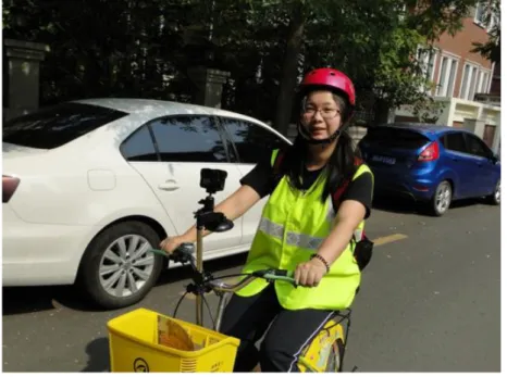
The data in this assessment are based on two sources. Assessments of the NMT improvement roads are based on data contained in the Feasibility Study Report, Baidu online maps and observations made during field visits conducted during July 2015. Data for access improvement to the mass transit system roads is based on video data collected during the field visits. Previous ChinaRAP assessments on roads in Tianjin, conducted in 2014, were also used.
Figure 2: Road inspections at Tianjin, China.
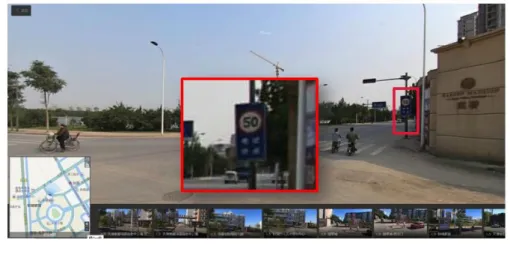
The level of risk of death or serious injury on a road is highly dependent on the speed at which traffic travels. iRAP policy is that risk assessments are made using the ‘operating speed’ on a road. Operating speed is defined as being the greater of the legislated speed limit or the measured 85th percentile speed. During the field visits, very few speed limit signs where observed. Figure 2 and Figure 3 inllustrates the data collection procedure.
Figure 3: Survey observation by Baidu Map
Table 1 lists a sample of key road attributes that were recorded along the road at the time of the baseline inspection. Table 1 allows for a direct impression of the road attributes. Each road attribute of the existing roads are summarized by their lengths. Total surveyed road length is 56.5 km. The key features of the existing roads that relate to risk of death and serious injury are:
Table 1: Key road inspection road attributes
Attribute Code - Category Length (km)
Carriageway 1 - Carriageway A of a divided road 12.1
2 - Carriageway B of a divided road 12.2
3 - Undivided road 32.2
4 - Carriageway A of a motorcycle facility 0.0
5 - Carriageway B of a motorcycle facility 0.0
Paved shoulder - drivers side 4 - None 28.9
3 - Narrow (≥ 0m to < 1.0m) 0.4
2 - Medium (≥ 1.0m to < 2.4m) 0.0
1 - Wide (≥ 2.4m) 27.2
Paved shoulder - passenger side 4 - None 4.6
3 - Narrow (≥ 0m to < 1.0m) 2.7
2 - Medium (≥ 1.0m to < 2.4m) 0.1
1 - Wide (≥ 2.4m) 49.1
Intersection type 8 - 4-leg unsignalised with no protected turn lane 5.2
17 - Mini roundabout 0.0
7 - 4-leg unsignalised with protected turn lane 0.1
10 - 4-leg signalised with no protected turn lane 9.2
Ändrad fältkod
13 - Railway Crossing - passive (signs only) 0.0
4 - 3-leg unsignalised with no protected turn lane 2.3
9 - 4-leg signalised with protected turn lane 4.9
6 - 3-leg signalised with no protected turn lane 2.6
3 - 3-leg unsignalised with protected turn lane 0.8
5 - 3-leg signalised with protected turn lane 1.5
14 - Railway Crossing - active (flashing lights / boom gates) 0.0
2 - Roundabout 0.8
1 - Merge lane 0.1
15 - Median crossing point - informal 0.0
16 - Median crossing point - formal 0.0
12 - None 29.0
199 - Do not use this code 0.0
Intersection channelisation 2 - Present 1.5
1 - Not present 55.0
Property access points 1 - Commercial Access ≥1 54.7
2 - Residential Access ≥3 0.0
3 - Residential Access <3 1.8
4 - None 0.0
Pedestrian crossing - inspected road 6 - Refuge only 0.0
5 - Unsignalised marked crossing without a refuge 6.0
4 - Unsignalised marked crossing with refuge 0.2
3 - Signalised without refuge 16.8
2 - Signalised with refuge 0.0
1 - Grade separated facility 0.0
7 - No facility 33.5
Pedestrian crossing facilities - side road 1 - Grade separated facility 0.0
2 - Signalised with refuge 0.1
3 - Signalised without refuge 14.1
4 - Unsignalised marked crossing with refuge 0.0
5 - Unsignalised marked crossing without a refuge 2.4
6 - Refuge only 0.0
7 - No facility 39.9
Pedestrian fencing 1 - Not present 52.2
2 - Present 4.3
Speed management / traffic calming 1 - Not present 56.5
2 - Present 0.0
Sidewalk - drivers side 4 - Non-physical separation 0m to <1.0m 0.0
3 - Non-physical separation 1.0m to <3.0m 0.0 2 - Non-physical separation ≥ 3.0m 0.0 1 - Physical barrier 0.0 7 - Informal path 0m to <1.0m 7.8 6 - Informal path ≥ 1.0m 17.1 5 - None 31.6
Sidewalk - passenger side 4 - Non-physical separation 0m to <1.0m 0.0
3 - Non-physical separation 1.0m to <3.0m 0.0
2 - Non-physical separation ≥ 3.0m 0.0
1 - Physical barrier 0.0
6 - Informal path ≥ 1.0m 17.1
5 - None 19.2
Service road 1 - Not present 56.1
2 - Present 0.4
4. STAR RATINGS
Star Ratings are based on road inspection data and provide a simple and objective measure of the level of safety which is ‘built-in’ to the road for vehicle occupants, bicyclists and pedestrians. Five-star roads are the safest while one-star roads are the least safe. Importantly, Star Ratings can be completed without reference to detailed crash data, which is often unavailable in low-income and middle-income countries. Motorcyclist Star Ratings were not assessed as the use of motorcycles is restricted in Tianjin.
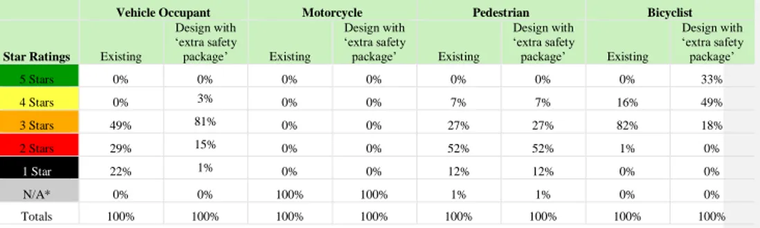
Table 2 displays the Star Ratings for the existing road, and design with suggested ‘extra safety package’ of countermeasures.
Table 2: Star Ratings of NMT roads
Vehicle Occupant Motorcycle Pedestrian Bicyclist
Star Ratings Existing
Design with ‘extra safety package’ Existing Design with ‘extra safety package’ Existing Design with ‘extra safety package’ Existing Design with ‘extra safety package’ 5 Stars 0% 0% 0% 0% 0% 0% 0% 33% 4 Stars 0% 3% 0% 0% 7% 7% 16% 49% 3 Stars 49% 81% 0% 0% 27% 27% 82% 18% 2 Stars 29% 15% 0% 0% 52% 52% 1% 0% 1 Star 22% 1% 0% 0% 12% 12% 0% 0% N/A* 0% 0% 100% 100% 1% 1% 0% 0% Totals 100% 100% 100% 100% 100% 100% 100% 100%
* No motorcycle star ratings were produced because motorcycle use is restricted in Tianjin.
Figure 4-Figure 7 explains the working procedure of the star rating and explain the star rating results for different road users by examples.
Ändrad fältkod
Figure 4:Field and map check of the existing roads pedestrian crossing facilities
Figure 6: Vehicle star rating example
Figure 7: Bycycles star rating example
5. SAFER ROADS INVESTMENT PLAN
The creation of the extra safety package involved an economic analysis of the safety components of the baseline and possible countermeasures. The economic benefits of the road safety investments are based on the number of deaths and serious injuries prevented and the economic cost of a death and serious injury. The cost of a death and a serious injury are based on research by RIOH and include
medical expenses, loss of economic output, property damage, traffic delays, environmental impacts, and other costs. The costs are as follows:
1)
2)
As guide, this cost for a death is equal to 64 times GDP per capita (current prices, 2014), which is a little less than the standard value of 70 times GDP capita used in iRAP analysis. The cost of a serious injury (equivalent to 16% of the cost of a death) is also less than the standard value used by iRAP (25%). For more information, see: http://www.irap.net/about-irap-3/research-and-technical- papers?download=45:the-true-cost-of-road-crashes-valuing-life-and-the-cost-of-a-serious-injury-espaol.
Applying the iRAP methodology, the analysis showed that the designs with the ”extra safety package” would result in an overall reduction in fatalities and serious injuries. It is estimated that, other things being equal, the design changes would result in 907 (39%) fewer fatalities and serious injuries over 20 years, saving CNY 247 million in crash costs avoided.
For detailed information about the economic analysis methodology, please see http://www.irap.org/en/about-irap-3/methodology.
Table 33Summary Economic Analysis(20 years)
Scenario Fatalities and
serious injuries Fatalities and serious injuries saved Fatalities and serious injuries saved (%) Economic benefit (m) Economic cost (m) Program Benefit cost ratio Existing 2335
Design with ”extra safety package” 1428 907 39% CNY 247 CNY 1,089 3.0
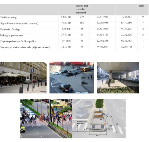
The package of suggested countermeasures is based on an economical viable (BCR>1) budget of approximately CNY 90 million (more information about the package is provided below). The following table lists some of the most promising countermeasures.
Table 4 Examples of SRIP countermeasures in the (20 years)
Row Labels Length
(km) Fatalities and serious Present value economic benefits Present value cost Benefit cost
Formaterat: Engelska (USA)
Ändrad fältkod
Formaterat: Engelska (USA) Formaterat: Engelska (USA)
Formaterat: Engelska (USA)
injuries that could be prevented
ratio
Traffic calming 54.80 km 249 67,871,911 7,244,413 9
Sight distance (obstruction removal) 19.80 km 158 42,905,956 6,410,250 7
Pedestrian fencing 6.30 km 65 17,821,060 9,757,125 2
Parking improvements 37.70 km 54 14,658,153 3,242,426 5
Upgrade pedestrian facility quality 144 sites 46 12,462,856 9,332,983 1
Footpath provision driver side (adjacent to road) 12.10 km 35 9,406,305 10,798,718 1
Figure 8: Countermeasures for NMT road safety improvements examples
6. SPEED SENSITIVITY ANALYSIS
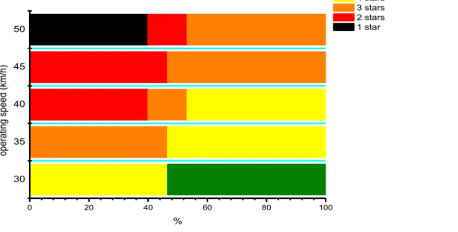
In the NMT roads, it was assumed that the operating speed is 50km/h and 45km/h based on limited nmber of speed signs within the area. To provide a sense of the impact of varying travel speeds, a speed test was done.
The analysis illustrates the impact that different operating speeds have on the pedestrian star ratings on the network of NMT roads: Haierbindao Road. It shows that as the operating speeds, the percentage of roads rated as low risk (5-stars and 4-stars) rapidly decreases. If speeds were 50km/h, none of the road sections would be rated 4- or 5-stars.
These analyses demonstrate that risk for pedestrians is highly sensitive to traffic operating speeds (as is the case for vehicle occupant and bicyclist risk). As is discussed later in the paper, speed management will be a critically important issue to consider during the preliminary and detailed design phases. During the design phases, further Star Ratings of designs can be conducted and the likely impact of various speeds can be more fully tested.
30 35 40 45 50 0 20 40 60 80 100 % op era tin g sp ee d (km/ h) 5 stars 4 stars 3 stars 2 stars 1 star
Figure 9: Changes in pedestrian Star Ratings with changes in operating speeds on the one of the NMT roads: Haerbindao
Road
7. DISCUSSIONS
The Star Ratings and SRIP and the analysis for NMT ROADS on existing, design with‘extra safety package’showed that:
1) The proposed ecomonic viable design with ‘extra safety package’ is estimated to cost CNY 90 million. If the extra safety package were added to the designs, it would result in 907 (39%) fewer fatalities and serious injuries, saving CNY 247 million in crash costs avoided. This is to further improve the safety benefits of the road upgrades. However, the ‘extra safety package’ itself would not result in the road all achieving at least 4-stars for all road users.
For the NMT roads, we identified many opportunities to be added in the designs. The adoption of these will be subject to decisions by the EA. Overall the systematic assessment of risk on the roads, and the interactive design with the local designers, is helping to create a safer outcome which can be objectively measured.
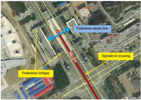
2) Perhaps the most pervasive challenge for pedestrian safety is the prevalence of vehicles driving and parking on footpaths. Although some form of footpath is provided along a large percentage of the roads assessed, footpath effectiveness is severely compromised by the presence of vehicles and other objects, requiring pedestrians to either share the footpath with vehicles or walk on roads. A high number of pedestrian crossings are also provided throughout the network, though the effectiveness of these is also compromised by vehicle parking. Moreover, many of the crossings are poorly designed or maintained. For example, crossings often do not align with pedestrian desire lines, such that pedestrians prefer to cross at locations that do not have pedestrian facilities. This often requires them to negotiate ineffective pedestrian fences.
3) There tends to be space allocated throughout the network for bicycles and e-bikes, either in the form of wide shoulders, which are often segregated by temporary fences, or service roads. This has a significant safety benefit for bicyclists. There is, however, an opportunity to improve the consistency of the provision of segregated lanes to create an uninterrupted network, and also to explore innovative options for intersections, such as the use of advance stop lines.
4) Traffic operating speeds are particularly important factor in road safety risk. There is a lack of speed limit signage throughout the network, so it was unclear what legal speed limits are. It is very likely that operating speeds vary significantly throughout the day as the level of congestion changes, and it is noted that the very large capacity of many of the roads means that during less congested periods, vehicles may be able to travel very fast. It is suggested that as part of the project, a speed management framework is adopted that balances road function and pedestrian and vehicle priority and recognises the relationship between collision speeds and fatality risk for different road users.
5) In order to make roads safer in Tianjin, efforts that go beyond engineering to ensure that planning and design is integrated with an appreciation of local road user behaviour will be necessary. It is suggested that as part of the project, a ‘safe system’ framework is implemented, which balances the need for safer roads, vehicles and people. This will require engagement of the community, police, educators and the vehicle industry.
6) Furthermore, significant benefits could be realised through coordinated targeting risk factors for road users such as: speeding, seat belt wearing, alcohol, driving/parking on footpaths and failing to yield at pedestrian crossings. Enforcement of laws relating to driving/parking on footpaths and failing to yield at pedestrians on pedestrian crossings will be especially important.
For future works, the researchers proposed that:
1) The local designers shall read the ‘Strip plans’ provided by the researchers. Each countermeasure on the plan should be regarded as a suggestion and must be subject to additional consideration during their design.
2) The researchers will assess the design based on the feedback on ‘strip plan’ for baseline from the designers to see how the designs will be changed by the risk assessment.
3) Prioritized countermeasures might need to be addressed to some of the roads for safety improvement and other means of safety improvements such as capacity building other than infrastructure improvement shall be considered.
ACKNOWLEDGEMENT
The research is funded by NSFC funded project: No. 51308263 In-depth crash analysis and development of traffic risk assessment model for "Highway Segments Passing Through Villages”.
REFERENCENCES
International Monetary Fund, 2014, World Economic Outlook Database,
http://www.imf.org/external/ns/cs.aspx?id=28.
RIOH, 2016, http://www.chinarap.net.
iRAP, http://www.irap.org/en/about-irap-3/methodology.
Tianjin Tianle International Engineering Consulting Co., Ltd.(2015) Feasibility Study Report. Tianjin Urban Transport Improvement Project.
World Health Organization, 2013, Global Status Report on Road Safety: Supporting A Decade of Action