THESIS
AN ANALYSIS OF STONE CIRCLE SITE STRUCTURE ON THE PAWNEE NATIONAL GRASSLAND, WELD COUNTY, COLORADO
Submitted by Jennifer K. Long Department of Anthropology
In partial fulfillment of the requirements For the Degree of Master of Arts
Colorado State University Fort Collins, Colorado
Fall 2011
Master’s Committee:
Advisor: Jason LaBelle Jason Sibold
ii ABSTRACT
AN ANALYSIS OF STONE CIRCLE SITE STRUCTURE ON THE PAWNEE NATIONAL GRASSLAND, WELD COUNTY, COLORADO
The purpose of this research is to create a context of stone circle site information on the Pawnee National Grassland that will contribute to the overall study of this valuable resource within Colorado, as well as throughout the Great Plains region. These data will provide a solid base for future research to be conducted on stone circles in Colorado. In order to better understand stone circle site structure, cluster analysis was utilized to expose patterns for three analyses which included overall site structure based on the landforms on which the site resides, stone circle gap direction as compared to overall site structure, and comparing prevailing wind directions and the portion of the stone circles with the highest stone counts.
To accomplish this, center points were collected with a GPS unit for each of the 249 stone circles recorded. Attributes were then documented including exterior
diameters, circle definition, gap direction, stone counts per octant, and associated artifacts and features. To determine overall site structure, nearest neighbor analysis was run in ArcGIS 9.3 yielding a spatial pattern of clustered, dispersed, or random. Next, an
attribute was included in the cluster analysis using the spatial autocorrelation test with the gap direction in degrees. This analysis also yielded a result of clustered, dispersed, or
iii
random. Finally, for the wind direction analysis, rose diagrams were created to compare each stone circle feature with the prevailing wind directions.
The findings for the site structure based on landform types consisted of the lowland sites being random in pattern, or consisting of less than three features. The midland sites were dispersed, and the highland sites were clustered or random. When comparing overall site structure with the direction of the gap, the random and clustered sites had a random pattern for gap direction. The dispersed site, however, had a clustered pattern. The clusters consisted of three stone circles facing the same direction, though each cluster faced a different direction. Finally, the result for prevailing wind direction and the highest stone counts was inconclusive. Additional research is necessary to provide more conclusive interpretations of this analysis.
iv
ACKNOWLEDGMENTS
I would like to begin by thanking my advisor, Jason LaBelle, for motivating me to continue working hard, for encouraging me to finish in a timely manner, and for helping me out when I most needed it. I have learned a great deal during the last two years, and I feel I am a better archaeologist for it. I would also like to thank the members of my committee, Jason Sibold and Janet Ore. Your advice and support are much appreciated. You all helped make this document as strong as possible, and I thank you.
My family and friends have been a constant source of moral support through these last two years. I would especially like to mention my parents and brother, Caryn Berg, Vanesa Zietz, Erica Menagh, Meredith Nicklas, Jessica Anderson, and Annie Maggard for being there for me when I needed a break from the chaos, and for the countless hours of discussion.
Finally, this thesis would not have been possible without the support and assistance of the US Forest Service. I am thankful to Nicole Branton for arranging this project, and providing the necessary equipment to complete the work. Your advice and guidance through this process was invaluable. I never would have made it past the research design without you. Thank you so much for being the best boss an archaeologist can have! I would also like to acknowledge the assistance of the Forest Service crew for helping me, when possible, get the stone circles recorded. In particular, I would like to thank Lindsey Mieras, Larry Fullenkamp, Mikah Jaschke, Dustin Hill, and Marcy Reiser. Your efforts, when it was a thousand degrees on the Pawnee in August, are greatly
v
TABLE OF CONTENTS
ABSTRACT ... ii
ACKNOWLEDGMENTS ... iv
LIST OF TABLES ... vii
LIST OF FIGURES ... viii
CHAPTER 1 – INTRODUCTION AND BACKGROUND ... 1
PURPOSE ... 5
Cluster Analysis ... 6
RESEARCH QUESTIONS ... 7
A BRIEF HISTORY OF STONE CIRCLE RESEARCH ... 9
STONE CIRCLE RESEARCH IN COLORADO ... 15
Amy Frederick’s Master’s Thesis ... 15
Site 5BL876 – The Indian Mountain Site ... 18
Site 5LR110 ... 19
Site 5LR200 – The T-W Diamond Site ... 20
Site 5LR201 – The Salt Box Site ... 21
Site 5LR286 ... 22
Site 5LR289 – The Killdeer Canyon Site ... 22
Site 5WL1298 – The Biscuit Hill Site ... 22
Keota Stone Circle District ... 23
Site 5WL2180 – West Stoneham Archaeological District ... 24
SUMMARY OF CHAPTERS ... 29
CHAPTER 2 – METHODS ... 30
DEFINITIONS OF A SITE AND A DISTRICT ... 30
Archaeological Sites ... 30
Archaeological Districts ... 33
“Siteless” Archaeology ... 34
Definition of a Site Revisited ... 36
DATA COLLECTION ... 41
CLUSTER ANALYSIS ... 44
CHAPTER 3 – LANDFORM AND SITE STRUCTURE ... 45
METHODS ... 45
Field – Data Collection ... 45
Lab – Data Analysis ... 48
PREVIOUS RESEARCH ... 49
RESULTS ... 54
Site 5WL1340 ... 54
vi
Site 5WL2413 ... 59
Site 5WL2658 ... 59
Site 5WL3169 ... 60
DISCUSSION ... 61
CHAPTER 4 – GAP DIRECTION AND SITE STRUCTURE ... 68
METHODS ... 68
Field – Data Collection ... 68
Lab – Data Analysis ... 69
PREVIOUS RESEARCH ... 70
RESULTS ... 74
Site 5WL2180 ... 74
Site 5WL2413 ... 78
DISCUSSION ... 80
CHAPTER 5 – WIND DIRECTION AND FEATURE STRUCTURE ... 91
METHODS ... 92
Field – Data Collection ... 92
Lab – Data Analysis ... 92
PREVIOUS RESEARCH ... 93
RESULTS ... 97
Site 5WL2413 ... 98
DISCUSSION ... 101
CHAPTER 6 – CONCLUSION... 107
RESEARCH QUESTIONS REVISITED ... 107
SITE STRUCTURE ... 110 Lowlands ... 111 Midlands ... 112 Highlands ... 113 FUTURE DIRECTIONS ... 114 REFERENCES CITED ... 118 APPENDIX I ... 123 APPENDIX II ... 137 APPENDIX III ... 158
Fort Collins, Colorado Average Wind Direction (%) 2005-2009, by Month ... 159
vii
LIST OF TABLES
Table 1 Summary of stone circles and landforms previous research. ... 53
Table 2 Summary of stone circle site structure and landform data. ... 60
Table 3 Total stone circles by site structure and landform type. ... 64
Table 4 Summary of the stone circle gap direction previous research. ... 73
Table 5 Summary of prevailing wind directions and stone counts previous research. .... 96
Table 6 Site 5WL363 stone circle data. ... 138
Table 7 Site 5WL367 stone circle data. ... 138
Table 8 Site 5WL456 stone circle data. ... 138
Table 9 Site 5WL1340 stone circle data. ... 139
Table 10 Site 5WL1445 stone circle data. ... 140
Table 11 Site 5WL2180 stone circle data. ... 141
Table 12 Site 5WL2413 stone circle data. ... 151
Table 13 Site 5WL2658 stone circle data. ... 153
viii
LIST OF FIGURES
Figure 1 A historic photograph from Banks and Snortland (1995:140) of a tipi. ... 1
Figure 2 Plan map of a complete stone circle found at site 5LR11622. ... 2
Figure 3 Plan map of a stone circle from site 5LR11622 with a large gap. ... 3
Figure 4 Plan map of a stone circle from site 5LR11622 with a higher stone counts. .... 4
Figure 5 Drawing of a Winnebago campsite in 1634 showing domed structures. ... 14
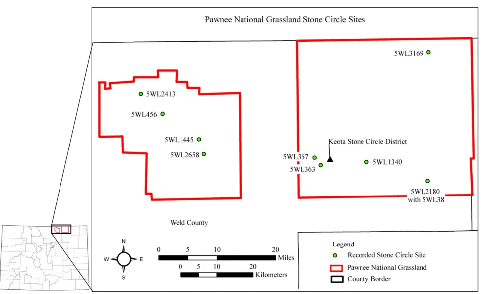
Figure 6 Stone circle sites in eastern Colorado and the sites recorded for this project. .. 16
Figure 7 East and west portions of the PNG. ... 31
Figure 8 Site 5WL2180 with previously recorded sites. ... 38
Figure 9 Site 5WL2180 with previously recorded sites and current stone circles. ... 39
Figure 10 Site 5WL2180 current stone circle locations.. ... 40
Figure 11 Example of a lowland landform showing the basin at site 5WL2180. ... 46
Figure 12 Example of a midland landform showing a bench at site 5WL2180. ... 47
Figure 13 Example of a highland landform showing a ridgeline on the PNG. ... 48
Figure 14 Site 5WL1340 nearest neighbor analysis from ESRI ArcGIS 9.3. ... 54
Figure 15 Site 5WL1445 nearest neighbor analysis from ESRI ArcGIS 9.3. ... 55
Figure 16 Site 5WL1445 directional distribution map showing a linear pattern. ... 56
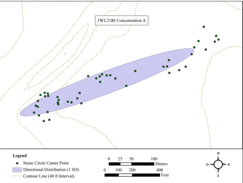
Figure 17 Site 5WL2180, Concentration A, nearest neighbor analysis. ... 57
Figure 18 Site 5WL2180, Concentration A, directional distribution map. ... 58
Figure 19 Site 5WL2180, Concentration B, nearest neighbor analysis. ... 59
Figure 20 Site 5WL2413 nearest neighbor analysis ... 59
Figure 21 Site 5WL2658 nearest neighbor analysis. ... 60
Figure 22 Site 5WL3169 nearest neighbor analysis. ... 60
Figure 23 Site 5WL2180, Concentration A, gap direction map. ... 75
Figure 24 Site 5WL2180, Concentration B, gap direction map. ... 77
Figure 25 Site 5WL2413 gap direction direction map. ... 79
Figure 26 Stone circle completeness by site and concentration. ... 80
Figure 27 Chart of the stone circle gap directions for each of the sites analyzed. ... 81
Figure 28 Site 5WL2180, Concentration B, gap direction clusters.. ... 85
Figure 29 Site 5WL2180, Concentration B group of stone circles facing center. ... 86
Figure 30 Possible clusters at site 5WL2180 Concentration A. ... 88
Figure 31 Possible clusters at site 5WL2413. ... 89
Figure 32 Example of octants used for stone counts. ... 92
Figure 33 Map of the direction of the highest stone counts at 5WL2413. ... 99
Figure 34 Chart of the most stone counts for features with a gap at site 5WL2413. ... 100
Figure 35 Possible clusters by highest stone counts and gap directions at 5WL2413. .. 105
Figure 36 Site 5WL363 map of stone circle center points. ... 124
Figure 37 Site 5WL367 map of stone circle center points. ... 125
Figure 38 Site 5WL456 map of stone circle center points. ... 126
Figure 39 Site 5WL1340 map of stone circle center points. ... 127
Figure 40 Site 5WL1445 map of stone circle center points. ... 128
Figure 41 Site 5WL2180 map of stone circle center points. ... 129
Figure 42 Site 5WL2180 map of stone circle center points, inset A. ... 130
ix
Figure 44 Site 5WL2180 map of stone circle center points, inset C. ... 132
Figure 45 Site 5WL2180 map of stone circle center points, inset D. ... 133
Figure 46 Site 5WL2413 map of stone circle center points. ... 134
Figure 47 Site 5WL2658 map of stone circle center points. ... 135
Figure 48 Site 5WL3169 map of stone circle center points. ... 136
Figure 49 Fort Collins January wind directions. ... 159
Figure 50 Fort Collins February wind directions. ... 159
Figure 51 Fort Collins March wind directions. ... 159
Figure 52 Fort Collins April wind directions. ... 159
Figure 53 Fort Collins May wind directions. ... 159
Figure 54 Fort Collins June wind directions. ... 159
Figure 55 Fort Collins July wind directions. ... 160
Figure 56 Fort Collins August wind directions... 160
Figure 57 Fort Collins September wind directions. ... 160
Figure 58 Fort Collins October wind directions. ... 160
Figure 59 Fort Collins November wind directions. ... 160
Figure 60 Fort Collins December wind directions. ... 160
Figure 61 Site 5WL2413 Feature 1 rose diagram. ... 161
Figure 62 Site 5WL2413 Feature 4 rose diagram. ... 161
Figure 63 Site 5WL2413 Feature 9 rose diagram. ... 161
Figure 64 Site 5WL2413 Feature 10 rose diagram. ... 161
Figure 65 Site 5WL2413 Feature 11 rose diagram. ... 162
Figure 66 Site 5WL2413 Feature 19 rose diagram. ... 162
Figure 67 Site 5WL2413 Feature 22 rose diagram. ... 162
Figure 68 Site 5WL2413 Feature 25 rose diagram. ... 162
Figure 69 Site 5WL2413 Feature 30 rose diagram. ... 162
Figure 70 Site 5WL2413 Feature 32 rose diagram. ... 162
Figure 71 Site 5WL2413 Feature 5 rose diagram. ... 163
Figure 72 Site 5WL2413 Feature 7 rose diagram. ... 163
Figure 73 Site 5WL2413 Feature 8 rose diagram. ... 163
Figure 74 Site 5WL2413 Feature 12 rose diagram. ... 163
Figure 75 Site 5WL2413 Feature 14 rose diagram. ... 164
Figure 76 Site 5WL2413 Feature 15 rose diagram. ... 164
Figure 77 Site 5WL2413 Feature 16 rose diagram. ... 164
Figure 78 Site 5WL2413 Feature 17 rose diagram. ... 164
Figure 79 Site 5WL2413 Feature 18 rose diagram. ... 165
Figure 80 Site 5WL2413 Feature 21 rose diagram. ... 165
Figure 81 Site 5WL2413 Feature 23 rose diagram. ... 165
Figure 82 Site 5WL2413 Feature 24 rose diagram. ... 165
Figure 83 Site 5WL2413 Feature 31 rose diagram. ... 166
1
CHAPTER 1 – INTRODUCTION AND BACKGROUND
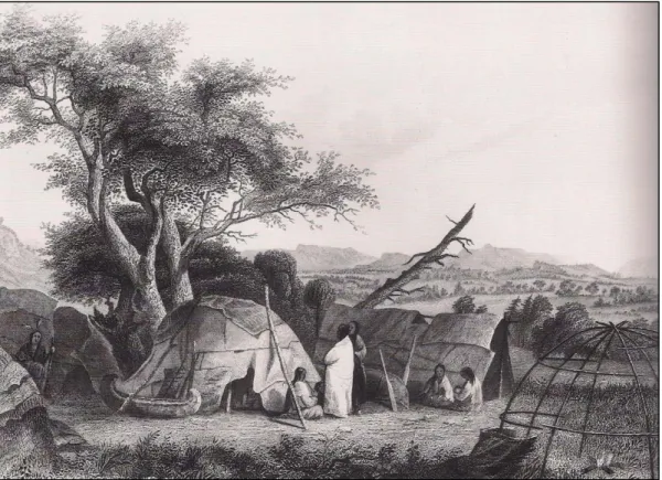
Stone circle sites are an underexplored archaeological resource in Colorado. Stone circles are often interpreted as the remains of tipis where the base of the tipi cover was lined with stones to hold it down (Malouf 1961:381). Figure 1 is a historic
photograph from Banks and Snortland (1995:140) depicting an example of the type of structure often associated with stone circles.
Figure 1 A historic photograph from Banks and Snortland (1995:140) of a tipi.
Once these structures were removed, the ring of stone from the base was all that remained. Figure 2 is an example of the archaeological remains of one of these
2
Figure 2 Plan map of a complete stone circle found at site 5LR11622. Recorded by the Colorado State University Archaeological Field School.
Stone circles may provide a vast array of information including the seasonality of an occupation, whether or not there were multiple occupations of the area over time, and how people chose to live on various types of landforms. Site structure is studied by analyzing the distribution of artifacts, features, and environmental elements related to past human behavior (Feder 2010:34). Through this analysis, the layout, or organization, of the camp can be determined and interpreted.
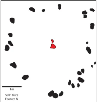
Certain attributes of stone circles will provide important information when interpreting site structure, such as the direction of the gap in the stone circle and which quadrants of the stone circle have the most stones. The gap within a stone circle has been interpreted as the possible doorway location of the original structure, which is discussed in detail in Chapter 4 (Kehoe 1958:871). Within the archaeological record, this gap is a large break within the ring of stone, as depicted in Figure 3, in the southeast quadrant of the circle.
3
Figure 3 Plan map of a stone circle from 5LR11622 with a large gap. Recorded by the Colorado State University Archaeological Field School.
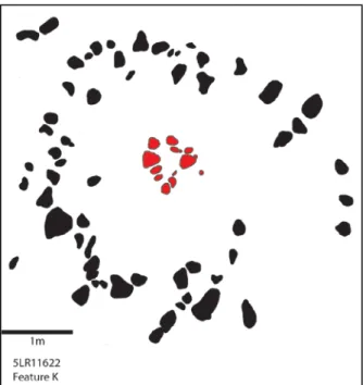
Another attribute that is important for interpreting site structure is the quadrant of the circle with the highest number of stones. This attribute has been interpreted as the direction of the prevailing winds at the time the structure was used, which will be discussed in detail in Chapter 5 (L. Davis 1983; W. Davis 1983; Quigg 1979). The highest number of stones is also visible in the archaeological record as depicted in Figure 4, where the highest number of stones can be seen in the southeast quadrant of the stone circle.
Stone circles are an important resource since they represent exactly where people of the past once lived, in the primary context. These features provide invaluable
information about how a camp was set up, how many different occupations occurred in a particular area, and how the type of landform on which the site resides influenced the arrangement of the camp. In short, these features provide a glimpse into how people once lived.
4
Figure 4 Plan map of a stone circle from site 5LR11622 with a higher concentration of stones in a quadrant. Recorded by the Colorado State University Archaeological Field
School.
Landforms on which the sites reside can range from lowlands, such as basins, up to highlands, such as ridge tops. In eastern Colorado, there are often subtle differences between the different types of landforms where a basin may only be 10 feet lower than a midland formation, such as a bench. There may be subtle differences between the types of landforms, but they are an important factor in where people chose to set up camp. Additional details and definitions for each landform type will be addressed in Chapter 3. For this research, to establish how a site was explicitly arranged and why, cluster analysis will be used to determine the different types of camp layouts of stone circles, within sites and between them.
5 Purpose
The purposes of my research are, first, create a context of stone circle site information for the USDA Forest Service that will enhance our understanding of this valuable resource on the Pawnee National Grassland (PNG), in Weld County, Colorado. With these data, the Forest Service will be able to manage this important cultural
resource more effectively. Second, this research is meant to establish whether cluster analysis can depict how sites were used by prehistoric peoples on the PNG. Third, this research will improve our knowledge of stone circle sites not only in Colorado, but throughout the Great Plains region as well.
With additional stone circle research in the plains of Colorado, a better
understanding of site structure and land use can be developed. This will be beneficial to interpreting archaeology within this area, and throughout the Great Plains region. With the previous research available on stone circles in the northern plains, comparisons are possible with the stone circles observed in Colorado. These comparisons allow for a better understanding of the similarities and differences for these various areas.
Continuing research in the underexplored areas of Colorado will allow for comparisons within Colorado, improving the analyses and interpretations that have already been made.
This research will be beneficial to archaeology since it will contribute to the existing data base for these and other housing types in the Great Plains and Rocky Mountains including pit houses, earth lodge villages, rock shelters, and wickiups. Together, these data will help to provide a more complete picture of how people have lived in the Great Plains throughout prehistory, and how past peoples made choices as to where to set up their camps. Furthermore, this research will be a strong foundation for
6
future research of stone circle sites in Northern Colorado allowing for further understanding of the past.
Cluster Analysis
To interpret the structure of the stone circle sites, a spatial analysis, in the form of a cluster analysis, will be used through GIS. Spatial analysis is a useful tool that can “reveal things that might otherwise be invisible – make what is implicit explicit”
(Longley et al. 2005:316). Specifically, this research uses spatial autocorrelation which compares location and attributes of certain spatial objects (Longley et al. 2005:88). Cluster analysis will determine if the stone circles are in groups, or clusters, are evenly dispersed, or are in a random pattern, also based on specific attributes.
Previous research has proposed several hypotheses regarding certain attributes observed in stone circle site structures. These hypotheses will be used to see how
effectively a cluster analysis will determine how peoples of the past were arranging sites. Cluster analysis is not new to tipi ring research, however, it is not widely used either. Day and Eighmy (1998) used an informal cluster analysis at the Biscuit Hill site (5WL1298) in Weld County, Colorado. Their informal analysis looked at the open spaces within and between what appeared to be clusters, for possible activity areas, and the direction of doorway gaps as a sign of a relationship between the rings within an apparent cluster, with the idea that the doorways would face the open space, or
community area (Day and Eighmy 1998: 16). Their use of an informal cluster analysis was to depict more clearly how the site was structured, and for what function (Day and Eighmy 1998).
7
W. Davis (1983:75) also used a cluster analysis to look at multiple variables, such as the exterior diameters of the stone circles and the distribution of stones within the features, according to a hierarchy, to observe patterns and determine structural
differences. The purpose of this analysis was to find patterns so that inferences about the differences in the data could be made with some statistical certainty (W. Davis 1983:77). The reason for using the cluster analysis was to expose similarities and differences within the data to better understand the function of stone circle sites overall (W. Davis 1983:78).
Both of these analyses depicted a valuable use for the cluster analysis technique when studying the function of stone circle sites. Day and Eighmy (1998:16), through their informal cluster analysis, were able to make hypotheses that would need further testing, but through the use of the cluster analysis, more questions about stone circle site structure were raised for additional research. W. Davis (1983:78) found through cluster analysis that the spacing of stones within a stone circle stayed constant even though the size of the circles were variable. In addition, cluster analysis depicted the morphological similarities within clusters including central rock concentrations, double courses of stones, and size of the stone circles (W. Davis 1983:78).
Research Questions
One purpose of this research is to analyze stone circle site structure on the PNG using a cluster analysis. To determine if cluster analysis is useful for understanding site
8
1. Does the spatial arrangement of features vary according to the type of landform?
o Hypothesis: The stone circles located on highlands will be clustered while those located in midlands and lowlands will be dispersed or random. The sites on the highlands have less space to spread out down the edge and, therefore, will exhibit more clustering (Reher 1983). The sites in the midlands and lowlands will have more options for use of space and, therefore, will be more dispersed in site structure.
2. Does the gap direction of stone circles vary by the spatial arrangement?
o Hypothesis: If the gap directions are based on wind direction, then they will likely vary within clustered and dispersed sites. With the wind coming from different directions during different seasons, variability would happen in areas that were used over multiple occupations. Both clustered and dispersed areas could have been used multiple times.
o Hypothesis: If the gap directions are based on social influences, then they will likely face a central location. As noted by previous research (Day and Eighmy 1998; Oetelaar 2000), some sites may have had central social locations and the gaps tended to face that specific area for better interaction.
o Hypothesis: If the gap directions are based on cultural ideals, then they will likely face the east, or rising sun. Previous research has observed (Banks and Snortland 1995; Hassrick 1964; Moore 1996; Oetelaar 2000) gaps facing all one direction, usually to the east. If this is the reason for
9
doorway placement, then cluster analysis will show a dispersed or clustered arrangement with the gaps.
3. Is there a correlation between prevailing wind direction and the direction with the highest stone count within a stone circle?
o Hypothesis: The direction with the highest number of stones will also be the direction of the prevailing winds for each season. Also observed in previous research (L. Davis 1983; W. Davis 1983; Quigg 1979), stone counts tend to be correlated with prevailing wind direction and should be observed in this research.
A Brief History of Stone Circle Research
Stone circle research began in earnest in the Great Plains region during the 1950s and 1960s. Mulloy (1952; 1954) conducted research in Wyoming with one specific research project in the Shoshone Basin. From his research, Mulloy (1952:137) considered stone circles to be a resource of unknown purpose. This conclusion was based on the paucity of artifacts usually associated with the stone circles as well as the absence of hearths and packed floors. Without these types of archaeological remains, it was difficult for Mulloy to view stone circle sites as former habitation areas. Mulloy (1952:137) also noted that most stone circle sites were located in unprotected areas, and it was often difficult to decipher individual circles since most intersected one another.
The protection from the environment, and enemies, was seen as an important factor by Mulloy in campsite locations and, therefore, made it even more unlikely that stone circles were evidence for such activities. From this line of evidence, Mulloy
10
(1952:137; 1954:54) considered these circles to be possible relations of medicine wheels, suggesting a more ceremonial purpose to the stone circles. Mulloy (1952:137) noted, however, that medicine wheels usually had linear stone alignments within the center of the circle, whereas the other stone circles did not. This did not deter Mulloy from his interpretation of stone circles since he was merely suggesting they are relations of the more ceremonial medicine wheel.
Two years later, Mulloy (1954:53) documented stone circle sites within the Shoshone Basin of Wyoming, furthering his interpretation of these sites as being of unknown function. Mulloy (1954:53) took issue mainly with stone circles being referred to as “tipi rings”, which automatically assumed the function of these sites. By using the term tipi ring, it was assumed that the stones within the circle were used to hold down the cover of the tipi at the edges of the base of the structure (Mulloy 1954:54). According to Mulloy (1954:54), there were too many stones observed within the circles than would have been needed for such a function, although he did not conduct research to determine what number of stones would be needed for this particular function. Artifacts, or the lack thereof, were also used as evidence for these sites not being for habitation. Mulloy (1954:54) asserted that had the circles been tipis, then there would have been a larger amount of artifacts to support any length of occupation, for the number of circles at the sites.
Mulloy (1954:54) also noted that the stone circles would not have had varying sizes throughout the sites, and there would have been wall gaps in the circles for the opening of the tipi, had the circles been used for habitation. Mulloy (1954:55) came to the conclusion that the stone circle sites were not for habitation, instead they were likely
11
of a more ceremonial function, and used for dancing or rituals. Wedel (1953:179) agreed with Mulloy that stone circles were likely ceremonial in nature given that these sites were “unassigned culturally” due to the paucity of diagnostic artifacts and features. Kehoe (1958:861), on the other hand, argued that there was sufficient evidence for determining function of stone circle sites, and that function was for habitation purposes.
Through ethnographic accounts, Kehoe (1958:861), while working in north central Montana and Alberta, was able to explain the purpose of stone circles, which he defined as the stones used to hold down the base of the tipi cover. The ethnographic accounts included those of early explorers and of Native Americans themselves. The explorers included Maximilian, Henry Hind, Washington Matthews, and J. N. Nicollet, all of which noted the use of stones to anchor the bases of the tipi structures (Kehoe 1958:861).
Native Americans interviewed by Kehoe also emphasized the use of stones as tipi anchors, to protect from the wind, and recalled that in the times before the horse was introduced to the Great Plains, people used dogs to carry materials around the country side (Kehoe 1958:868). According to an ethnographic account given by Bull Head of the North Piegan, the “dog people” only used stones to anchor the tipis while the “horse people” would use both stones and wooden pegs (Kehoe 1958:868). It was noted that wooden pegs were not used before the European contact era, due to a lack of tools such as an axe, to make and sharpen the pegs (Kehoe 1958:869). Kehoe (1958:870)
introduced further evidence from ethnographic accounts, to strengthen his assertion of stone circles being part of habitation sites, from Adam White Man, a South Piegan, who recalled that cooking was only done inside the tipi during bad weather otherwise the
12
outdoor hearths were utilized. This explanation speaks to the lack of features within the stone circles that Mulloy used, partly, to interpret the rings as for only ceremonial purposes.
Additionally, through ethnographic accounts, Kehoe (1958:863) noted that, in the northern plains, stone circle sites were set up in coulees during the winter and moved to higher ground during the spring, to avoid flooding of the area. Not all sites, however, were located in ideal camping locations. Often, camp sites occurred wherever was possible and when necessary. Kehoe (1958:863) quoted Mae Williamson as stating that if the group was caught in a blizzard, for example, camp was set up wherever it was possible, which may have been a less than ideal location. Circumstances such as these make it difficult to predict where a stone circle site may be located, since they do not always follow a specific pattern.
A pattern mentioned by Kehoe (1958:862) was that of the size of the stone circles and temporal change. He asserted that the stone circles were smaller when people only had dogs to help haul materials from location to location, and became larger when the horse was introduced to the Great Plains, since horses were capable of hauling more material for larger tipis (Kehoe 1960:434). Kehoe (1958:861) used this interpretation to explain why the stone circles in his study area varied from 7 ft (about 2 m) to over 30 ft (over 9 m) in diameter.
While making his argument for stone circles as habitation sites, Kehoe (1958:872) utilized the term tipi ring for the stone circles he believed to be habitation versus those that were for ceremonial purposes. Although the term tipi ring has been used as a descriptor for these specific features, it may not be an accurate depiction of the structure
13
it once was associated with. Malouf (1961) noted multiple types of structures that have a stone circle associated with it. These structures included partial circles, single-course rings, multiple-course rings, circular walls, corrals and forts, and medicine wheels (Malouf 1961:382). Similar to Kehoe, Malouf (1961:382-3) noted that stone circle sites tended to be located in good camping locations and that not many artifacts were usually observed with the rings due to short-term occupations associated with the hunter-gatherer lifestyle. Malouf (1961:383) also observed larger artifact concentrations at stone circle sites that were associated with bison kill sites, since there would have likely been a longer occupation for such an event.
Kehoe (1960) interpreted stone circle diameter as an indication for multiple occupations of an area, believing the rings increased in size through time. Malouf (1961:382), however, saw partial stone circles as the same such indicator, since stones were likely robbed from an older ring to create a newer ring. The diameter of the stone circles became problematic for Malouf (1961:385) who observed rings ranging from 2 ft (less than a meter) to 80 ft (over 24 m), which would be far too large for a conical structure. Because of this, Malouf (1961:386) postulated that any stone circle over 30 ft (over 9 m) was probably not domestic, but rather ceremonial in function. Referring to stone circles as tipi rings was also problematic for Malouf. He noted that the Shoshoni constructed a circular lodge made of poles, willows, and brush that was covered with grass mats (Malouf 1961:386). Since other circular structures can have stone circles associated with them, the term tipi ring is too specific and “not always true” (Malouf 1961:388). Figure 5 is a drawing of a Winnebago campsite from 1634 with domed structures that also have a circular base (Treuer et al 2010:28).
14
Figure 5 Drawing of a Winnebago campsite in 1634 showing domed structures that have circular bases. Picture from Treuer et al (2010:28).
Although they did not always agree, Mulloy, Kehoe, and Malouf set the ground work for stone circle research. Mulloy (1954) suggested much more research was needed to truly understand the meaning of stone circles. Kehoe and Malouf opened discourse, and provided evidence that stone circles were not all ceremonial in function, but were also the remains of habitation sites. Because of their initial research, archaeologists today are able to expand stone circle research throughout the Great Plains, for a better
15 Stone Circle Research in Colorado
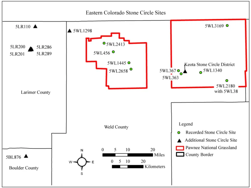
Stone circles have been researched in Colorado, though most of the site documentation available is in the form of site reports, providing little in the way of interpretation. This section reviews research and reports for Colorado State University alumni Amy Frederick’s research, and sites 5BL876, 5LR110 5LR200, 5LR201, 5LR286, 5LR289, 5WL1298, the Keota Stone Circle district in Weld County, and
5WL2180 the West Stoneham Archaeological District. These sites and the sites recorded for the current research are shown in Figure 6. The sites summarized offer a sample of stone circle sites throughout northeast Colorado to provide a background of some of the previous work completed.
Amy Frederick’s Master’s Thesis
Frederick (2010:10) conducted research near the town of Grover, in Weld County Colorado, near the northern border where Wyoming and Nebraska meet. Within the study area there were four stone circle sites consisting of the Baugh Pasture Site, the Indian Overlook Site, the Rocky Point Site, and the Tower Butte Site. Below is a summary of each of these sites.
The Baugh Pasture Site
This site was located on a north-south trending butte and consisted of 28 stone circle features along with fire altered rock concentrations, and associated artifacts (Frederick 2010:73).
16
17
The average diameter for the stone circles was 3.64 meters north-south by 3.52 meters east-west. The largest stone circle was 5 meters by 3.9 meters, and the smallest was 1.3 meters by 1 meter. No diagnostic artifacts were noted.
The Indian Overlook Site
The Indian Overlook Site was located on a butte and consisted of eight stone circles along with two fire altered rock concentrations and associated artifacts (Frederick 2010:87). Of the eight stone circles, one had three courses of stone stacked on top of each other, creating a short wall. This feature measured 2.65 meters by 3.14 meters by 45 centimeters high, and was made up of 85 stones (Frederick 2010:89). This feature also had associated ceramic sherds and two mid stage bifaces (Frederick 2010:89). The author interpreted this feature as a possible eagle trap. The additional seven stone circles had an average size of 4.89 meters by 4.63 meters with the largest circle at 5.6 meters in diameter, and the smallest circle at 4.06 meters by 4.8 meters (Frederick 2010:89). Frederick (2010:90) noted that the gap directions were mostly to the east for these stone circles. The landowner that located the site noted that more stone circles were present at one time, but are now buried (Frederick 2010:90).
The Rocky Point Site
This site was located on a butte and consisted of two stone circles along with one hearth and two fire altered rock concentrations (Frederick 2010:91). The largest stone circle was 3.7 meters by 4.6 meters, and the smallest circle was 2.7 meters by 3.6 meters (Frederick 2010:94). The associated artifact assemblage included 14 projectile points
18
with Middle Archaic, Late Archaic, Late Prehistoric, McKean, and Avonlea points (Frederick 2010:92).
The Tower Butte Site
The Tower Butte Site was located on a flat plain, under a sandstone overhang, and consisted of 49 stone circles along with 5 fire altered rock concentrations, a lithic scatter, and a historic dump (Frederick 2010:95). The average size of the stone circles was 3.3 meters by 3.27 meters with the largest circle at 5.1 meters by 4.2 meters, and the smallest at 1.1 meters by 1.2 meters (Frederick 2010:97). The artifact assemblage consisted of projectile points from the Early Archaic, Late Archaic, Protohistoric, and historic time periods (Frederick 2010:95).
Site 5BL876 – The Indian Mountain Site
The Indian Mountain Site is located in a clearing in the Dakota hogbacks, near Lyons, Colorado (Cassells and Farrington 1986:129). The site was excavated partly by high school students participating in an archaeological field school. The stone circles and the areas between them were excavated (Cassells and Farrington 1986:129). The site consisted of at least 10 stone circles that were separated into 3 areas (Cassells and
Farrington 1986:129). The three areas consisted of Area 1 with seven stone circles, Area 2 with one stone circle, and Area 3 with two stone circles (Cassells and Farrington 1986:130). Of the 10 stone circles, 4 were excavated and 2 were sampled (Cassells and Farrington 1986:130).
Area 1 provided two dates from hearths within the rings. The first radiocarbon date was approximately AD 727 (1280 +/- 195 BP) and the second date was
19
approximately AD 845 (1120 +/- 200 BP) (Cassells and Farrington 1986:131-2). Area 3 only provided one date of 218 BC (2140 +/- 200 BP), from charcoal located inside Ring 4 (Cassells and Farrington 1986:132). The two stone circles (Ring 4 and Ring 5) within Area 3 had the most artifacts in the rings and the surrounding area, compared to any of the other two areas (Cassells and Farrington 1986:132). The artifacts included 1 projectile point tip, 1 scraper, 2 ceramic sherds, and 59 flakes (Cassells and Farrington 1986:132). The material types for the flakes were clustered in separate areas with Ring 4 having red quartzite, yellow chert in Ring 5 and white chert in an area outside both of the rings (Cassells and Farrington 1986:134). The authors interpreted this as being a
campsite where a single knapper created each pile of the debitage.
The evidence of pottery at a site this far west, with such an early date (215 BC), was interpreted by the authors as either migrating groups coming from the east, or the vessel was traded from the east to the west (Cassells and Farrington 1986:138). The hypothesis of learned ceramic production was deemed not likely by the authors due to the small amount of sherds observed at the site (Cassells and Farrington 1986:138).
Site 5LR110
Site 5LR110 was located on an arroyo bank and consisted of at least 12 large stone circles ranging in size from 6.5 m to 10.0 m (Morris et al. 1983:53). No artifacts were observed at the site. The possible date of AD 1600 was determined by the interpretation that stone circles increased in size when the horse was introduced to the Great Plains (Morris et al. 1983:53). No radiocarbon dates were reported.
20 Site 5LR200 – The T-W Diamond Site
The T-W Diamond Site (5LR200) was located on a ridge top, in the ecotone boundary of the Rocky Mountain foothills and the eastern plains, 23 miles north of Fort Collins, Colorado (Flayharty and Morris 1974:161). Surface artifacts consisted of only potsherds, 1 core, 4 scrapers, and 14 flakes, leading the authors to conclude that the surface had likely been collected by looters (Flayharty and Morris 1974:162). The ridge altogether, not just the site area, had more tools than flakes, producing projectile points, bifacially flaked blades, and scrapers (Flayharty and Morris 1974:162). The authors interpreted the site to have been used for hunting, butchering, and collecting activities, based on the artifacts observed (Flayharty and Morris 1974:162).
Excavations of the site were conducted in 1971 as part of the Colorado State University Archaeological Field School. Excavations were kept within the stone circles and the immediately surrounding areas (Flayharty and Morris 1974:162). The site
consisted of 47 stone circles that stretched along the ridge top for approximately a quarter mile, and according to the authors, had no apparent pattern to the site structure, although the site appears to have a slight linear distribution (Flayharty and Morris 1974:163). Of the 47 stone circles, 17 were excavated (Flayharty and Morris 1974:163). The diameters of the stone circles mostly ranged from 16 ft (4.9 m) to 18 ft (5.5 m) with no
distinguishable wall gaps, or entry areas (Flayharty and Morris 1974:163). The authors noted that most of the rings had larger stones located in the northwest portion of the structure, which was also the side of the prevailing winds (Flayharty and Morris 1974:163).
21
Seven of the stone circles excavated had internal hearths, which were noted as being poorly defined by the authors (Flayharty and Morris 1974:163). Dates for the site ranged from AD 400 +/- 340 to AD 1170 +/- 220 (Flayharty and Morris 1974:163). Excavated artifacts included 139 pottery sherds, 30 projectile points and fragments, 14 of which were diagnostic, 7 scrapers and fragments, 1 biface, 1 spokeshave, 28 utilized flakes, 3 cores, 1 steatite pipe, and 1,027 flakes (Flayharty and Morris 1974:165-7).
Flayharty and Morris (1974:168) asserted that the pottery from the site was likely from one vessel broken into many pieces, providing evidence for a short occupation of the site. Initially, the authors thought the site was of one, short occupation due to the poorly defined hearths, no evidence of a midden, and, according to the authors, a paucity of artifacts, though the site does indeed yield a large amount of artifacts (Flayharty and Morris 1974:163;168). The interpretation of a single camp was also suggested due to a lack of partial stone circles or overlapping rings (Flayharty and Morris 1974:163). The range of radiocarbon dates for the site suggests otherwise.
Site 5LR201 – The Salt Box Site
Site 5LR201 exhibited multiple occupations beginning from at least the Middle Archaic (Morris et al. 1983:53). Artifacts included corner-notched and side-notched projectile points from the Middle Archaic, Late Archaic, Early Ceramic, and the Middle Ceramic periods (Morris et al. 1983:53). A small Middle Ceramic side-notched
triangular projectile point was associated with the stone circles, but the author noted that Early Ceramic projectiles had been associated with stone circles in other research (Morris et al. 1983:53).
22 Site 5LR286
Site 5LR286 was located on top of a high ridge near the T-W-Diamond Site (Morris et al. 1983:55). The site consisted of six stone circles along with numerous flakes, two projectile points, and stone tool fragments (Morris et al. 1983:55). One of the projectile points recorded was possibly a Late Archaic point (Morris et al. 1983:55).
Site 5LR289 – The Killdeer Canyon Site
Site 5LR289 was located on the bottom of Killdeer Canyon consisting of 18 stone circles dating from 150 +/- 50 BP to 360 +/- 80 BP (approximately AD 1590 to 1800) (Morris 1989:238). Artifacts observed included triangular side-notched concave-based projectile points, plain pottery fragments, ground stone metate and mano fragments, and flakes (Morris 1989:238). According to Morris (1989:238), the stone circles resembled the T-W Diamond Site in size, and the artifacts were similar as well. The main
differences were the geographic locations of the two sites and the plain versus incised pottery (Morris 1989:238). The site’s function therefore, was also likely similar to that of T-W Diamond as a short occupation camp for hunting activities.
Site 5WL1298 – The Biscuit Hill Site
The Biscuit Hill Site was located in a broad, flat basin near Lone Tree Creek, in Weld County, Colorado (Day and Eighmy 1998:2). The site was surface recorded by the Colorado Archaeological Society in 1987 (Day and Eighmy 1998:2). The site was divided into a northern locus and a southern locus, and consisted of 78 stone circles that
23
were included in over 100 stone features at the site (Day and Eighmy 1998:4). The artifacts consisted of 1 reworked projectile point, 1 end scraper, 1 glass bead, and 14 flakes (Day and Eighmy 1998:4).
Interpretations of the site focused on site structure and feature attributes. No radiocarbon dates were collected. Day and Eighmy (1998:7) discussed multiple
occupations at the site, but did not find evidence supporting such an interpretation. The authors noted that none of the stone circles were partial circles, or overlapping, and only two were touching, which was described as more of a lack of evidence for multiple occupations (Day and Eighmy 1998:7). The authors also looked at the size of the stone circles observing that there was no evidence for clustering of specific size classes within the site, noting the sizes were rather mixed throughout the site (Day and Eighmy 1998:7). Finally, the authors suggested the depth of the stones within each circle may be an
indicator of relative age. The stones in the northern locus were embedded deeper than the stones in the southern locus, possibly suggesting the northern locus was from an older occupation (Day and Eighmy 1998:17). Day and Eighmy (1998:17) did not, however, believe that was the case, and suggested that geomophological processes may have been a more likely explanation for the differences in stone depth. Since no radiocarbon dates were collected from the site, a more concrete interpretation was not possible.
Keota Stone Circle District
The Keota Stone Circle District was originally recorded in the spring of 1978, and is located in Weld County Colorado near the town of Keota. The district consists of four stone circle sites including 5WL354, 5WL358, 5WL359, and 5WL360 (Halasi 1978).
24
All of these sites are located in a draw, south of an east-west trending rock outcropping (Halasi 1978).
According to the report and site forms, site 5WL354 consists of 63 stone circles split between two concentrations within the draw (Halasi 1978:17). The associated artifacts were dated by Halasi (1978:17) based on artifacts to the Late Preceramic. Site 5WL358 consisted of 14 stone circles and 2 stone alignments, along with an associated lithic scatter dated by Halasi (1978:18) based on artifacts to the Middle Preceramic. Site 5WL359 consisted of two stone circles and one fire cracked rock concentration (Halasi 1978:18-19). Finally, site 5WL360 consisted of 76 stone circles and partial stone circles along with 2 rectangular stone alignments (Halasi 1978:19). Together, these sites make up the District.
Site 5WL2180 – West Stoneham Archaeological District
The West Stoneham Archaeological District is located on a rare landform for eastern Colorado (Brunswig 2003:51). The area consists of playa basins surrounded by large rock outcroppings which create a protective shelter from the elements (Brunswig 2003:52). Water is available in a temporary form from the playa basins and standing water that accumulates in the rock outcrops after rain and snow (Brunswig 2003:52). For more permanent sources of water, the South Pawnee Creek is locate 3.6 kilometers to the north and the South Platte River is located 36 kilometers to the southeast (Brunswig 2003:52).
25
John Wood’s Dissertation – 1967
Wood (1967) recorded seven sites at the West Stoneham Archaeological District for his dissertation including one stone circle site and six rock shelter sites. The stone circle site was 5WL38, the Hatch Site, located in the western portion of the basin, on the east side of the north-south-trending rock outcroppings and estimated to have
approximately 12 stone circles (Wood 1967:386). Wood (1967:386) noted that the site had been heavily collected prior to recordation, along with two holes dug into the middle of two stone circles by pot hunters. Excavation of two of the stone circles yielded a date of approximately AD 1790 (less than 160 BP) from the hearth in Feature 1, that was associated with artifacts from stratum II, and the earliest occupation noted in stratum IV (Wood 1967:392). Feature 2 also had a shallow hearth with bison bone associated with it (Wood 1967:395). Artifacts observed included a projectile point fragment, a ground stone slab located in the hearth of Feature 1, and 132 pottery sherds (Wood 1967). The majority of the pottery was located in stratum IV (Wood 1967:415). The site was interpreted as a hunting camp with a possible reuse of the site due to the close proximity of the stone circles (Wood 1967:417).
Robert Brunswig’s Dissertation – 1996
According to Brunswig (1996:93), the West Stoneham Archaeological District was located in “a relatively rare landform on the Colorado Piedmont, a discrete series of rock outcrop ridge lines encircling a series of interconnected, east to west trending, playa basin valleys.” The University of Northern Colorado conducted 5 field schools at the district, collecting 13 radiocarbon dates for 5 sites, along with projectile point typologies
26
for dates (Brunswig 1996:116). In total, 18 of the sites were dated by Brunswig either through projectile point typologies or radiocarbon dates (Brunswig 1996:267).
For his research, Brunswig (1996) was concerned with the sites dating from the Late Archaic to the Middle Ceramic time periods. Only the sites falling into these time periods were included in his dissertation, therefore, only the stone circle sites from those periods will be summarized here.
Late Archaic
Site 5WL1840 was located in the southwestern portion of the playa basin
consisting of 37 stone circles (Brunswig 1996:286). Brunswig (1996:286) stated that the artifacts observed at the site included two corner-notched projectile points which placed the site in the Late Archaic time period, but no specific details about these tools were provided.
Site 5WL1844 was located 30 m north of site 5WL1840 and consisted of 14 stone circles (Brunswig 1996:287). The artifacts included one corner-notched projectile point, also placing the site in the Late Archaic time period, but no specific details were provided for this projectile point (Brunswig 1996:287).
The last of the Late Archaic time period sites was 5WL1857, which was located on a south facing slope along the east-west-trending rock outcrop in the northeastern most portion of the basin (Brunswig 1996:287). The site consisted of two stone circles and “an upper biface fragment having typological traits comparable with other regional Late Archaic specimens” (Brunswig 1996:287). No additional details about these tools were provided by the author.
27 Early Ceramic
Site 5WL1849 was located on the north-south-trending rock outcrop in the
northwestern most portion of the playa basin (Brunswig 1996:331). The site consisted of one circular rock wall feature measuring 20-30 cm high and 4 m in diameter (Brunswig 1996:332). Artifacts placed the site in the Early and Middle Ceramic and also in the prehistoric or early historic time periods, along with radiocarbon dates of 700 +/- 70 BP and 1170 +/- 70 BP (approximately AD 780 to 1250) (Brunswig 1996:332).
Site 5WL2002 was located north of the east-west-trending rock outcrop in the northeast portion of the playa basin (Brunswig 1996:336). The site consisted of one stone circle yielding 93 flakes during excavations (Brunswig 1996:336). Based on a “diagnostic, hafted biface” the site was dated to the Early Ceramic (Brunswig 1996:337). No additional details were provided about the biface.
Site 5LW38, the Hatch Site, was also excavated by Brunswig (1996:347) yielding a radiocarbon date of 880 +/- 50 BP, placing the range of dates from 917 to 690 BP (AD 1033 to 1260). Additional pottery was observed during excavations by Brunswig (1996:352) and was interpreted as being from the Middle Ceramic time period. Other artifacts observed included 1 drill tip, 2 biface fragments, 2 retouch flakes, 1 leaf-shaped, corner-notched projectile point, 1 side-notched, flat based projectile point, 2 knives and 86 faunal fragments (Brunswig 1996).
Site 5WL1994 was located on a hilltop in the northeastern most portion of West Stoneham consisting of 14 small stone circles (Brunswig 1996:359). The dates for this
28
site were determined by two “hafted bifaces” dated to the Early Ceramic time periods, but no specific details about these tools were provided (Brunswig 1996: 359).
Site 5WL2131 was located within the playa basin at the western portion consisting of an undetermined number of small stone circles in a linear arrangement (Brunswig 1996:360). The date for the site was based on a small triangular, corner-notched projectile point to the Early Ceramic (Brunswig 1996:360). No additional details about the projectile point were provided.
Brunswig (1996:372) asserted that 20 percent of the stone circle sites were from the Early Ceramic and 17 percent were from the Middle Ceramic, although it was not mentioned which sites were from each period. According to Brunswig (1996:373), West Stoneham had a 2,500 year occupation span from 3350 – 880 BP (approximately 1400 BC to AD 1070) with a 400 year time gap from 1920 – 1510 BP (approximately AD 30 to AD 440).
The West Stoneham Archaeological District consisted of multiple stone circles along with lithic scatters and rock shelters. These cultural resources ranged in date from the Late Archaic to historic times, based on radiocarbon dates and projectile point typologies. The landform at West Stoneham is rare for eastern Colorado, making it an important resource to study.
Research in Colorado has produced stone circle sites ranging from at least the Late Archaic to historic times. These sites range in size with small sites of a few stone circles to over 70 stone circles observed. The sites are located in lowlands and on ridge tops. Some have very few artifacts while others have many. Having such diverse stone
29
circle sites in Colorado increases the need for additional research to gain a better understanding of how people were living throughout the past.
Summary of Chapters
The following chapters attempt to answer the questions set forth earlier in this chapter. Chapter 2 addresses the methods used for this research for in the field and in the lab, and the definitions of terms used for this project. Chapter 3 is an analysis and
discussion of stone circle site structure and the type of landforms on which the sites reside. Chapter 4 is an analysis and discussion of stone circle site structure in relation to the direction the gap is facing in the ring of stone. Chapter 5 is an analysis and
discussion of individual stone circle structure in relation to prevailing wind directions. Chapter 6 is the conclusion with a final summary of the research along with some suggestions for future directions of stone circle research.
30
CHAPTER 2 – METHODS
This research was conducted on the Pawnee National Grassland (PNG) in Weld County, Colorado. The sites recorded were selected from previously recorded sites that could be relocated. Some sites that had been recorded in the 1940s could not be relocated due to a lack of location information. The sites that were recorded include the West Stoneham Archaeological District (5WL2180), along with eight additional sites located throughout the Grassland (5WL363, 5WL367, 5WL456, 5WL1340, 5WL1445,
5WL2413, 5WL2658, and 5WL3169) (Figure 7).
Definitions of a Site and a District
Defining an archaeological site is not a simple concept. In order to understand the definition of a site for the current research, an examination of various ways to record the archaeological record is necessary. Since this research was conducted on the PNG, cultural resource management regulations for defining a site will be examined followed by the concept of “siteless” archaeology which allows for better interpretation of the entire archaeological record. The current project uses a combination of both of these concepts for defining a site, and is explained below.
Archaeological Sites
The term “site” can have many different definitions to many different archaeologists. A site is used as a unit of analysis for interpretation as well as for
31
32
management purposes through Section 106 of the National Historic Preservation Act (NHPA) of 1966. Any Federal agency managing Federal lands, such as the Forest
Service, are required to comply with Section 106 in order to protect historic properties on their lands, such as the PNG (Seifert et al 1997:1). Section 301(5) of the NHPA defines historic properties as follows:
“Historic property" or “historic resource" means any prehistoric or historic district, site, building, structure, or object included in, or eligible for inclusion on the National Register, including artifacts, records, and material remains related to such a property or resource [ACHP 2009].
This definition for historic properties only refers to the cultural resources that are significant enough, or eligible, for listing on the National Register of Historic Places (NRHP) (King 2008:372). This definition, therefore, does not address any cultural resources that are not eligible for listing on the National Register. The National Parks Service (NPS), which manages the NRHP, defines a site as:
… the location of a significant event, a prehistoric or historic occupation or activity, or a building or structure, whether standing, ruined, or vanished, where the location itself possesses historic, cultural, or archaeological value regardless of the value of any existing structure [NPS 1995:5].
This definition of a site does include cultural resources that are not eligible for listing to the NRHP, but does not specifically address what a site is. The complexity of defining the boundary of a site, considering many sites are buried, is usually the cause for this vagueness (Seifert et al 1997:30). According to Seifert et al (1997:5), it is up to the archaeologist recording the site to justify what the boundary of the site is and, therefore, what constitutes a site. Since
33
archaeology varies greatly from state to state, this vague definition allows for each archaeologist to determine what is significant and how best to protect and/or interpret the cultural resources they are managing. For example, the boundary justification for a prehistoric habitation site would include the extent of surface, and if possible buried, archaeological evidence (artifacts, features etc.) along with topographic features that limit the use of the spatial area (NPS 1997:32). Once a site boundary is created, it is not set in stone. Other archaeologist may alter the boundary as needed given that natural and cultural transformations are
continuously changing the archaeological record.
The NPS has provided guidelines for how best to determine a site boundary, but the system is not perfect. Since every archaeologist is creating their own definition of a site, there is no good way to compare data from, or interpretations about, sites. Site boundaries are still necessary for the
management side of archaeology in order to best protect the cultural resources and, therefore, will not be going away anytime soon.
Archaeological Districts
Archaeological districts are another aspect of managing sites. The NPS defines a district as being a “unified entity” of various cultural materials such as sites, buildings, features, and artifacts that are interrelated within a concentration or continuous formation throughout a spatial area (NPS 1995:5). Since a district can represent one activity, several activities, or include several sites, it is once
34
again left up to the recording archaeologist to justify the boundary, and determine what constitutes a district (NPS 1995:5; Seifert et al 1997:30).
The NPS (1997:33) provides an example for the boundary justification of a contiguous archaeological district as the clustering of sites and the restriction of topographic features. This boundary definition for a district is quite similar to that of a site boundary, which is basically the clustering of features and artifacts that are confined to a topographic area. Why, then, would an archaeological district not be considered one large archaeological site instead of a clustering of sites?
“Siteless” Archaeology
The concept of “siteless” archaeology has many names including distributional archaeology and landscape archaeology. According to Ebert (1992:6), a site is not something that can be defined, but must be in order to evaluate it. One problem with grouping concentrations of archaeological
materials into a single unit, such as a site, is that areas are often reused over time, making it difficult to associate specific artifacts with specific events or activities (Ebert 1992:10). Another issue with creating sites is how landscapes are used within a single system of human activity (Ebert 1992:11). Dunnell (1992:26) concurs stating that even for management purposes, the site concept removes portions of the archaeological record. Dunnell (1992:29) asserts that if sites are not units of formation then they cannot be used as units of observation. Along those lines, Ebert (1992:11) suggests that many aspects of this system interact, including the archaeological record, mobility of people, and the environment. For
35
example, two “sites” could actually be part of one event with one site being the habitation area and the other site being the location of the hunt. Both of these sites are from a single time, but have different locations and different
archaeological materials. As suggested by Ebert (1992:11), these two sites would not be sites at all, but rather they would be parts of a single system of human activity.
According to Ebert (1992:48), sites are generally defined as “spatially discrete locus of cultural material that can be interpreted.” The concern with this definition is that sites exist both in the past and in the present. The site is both the location of the past behavior and the location of the archaeological record that exists today (Ebert 1992:47-8). Interpretation of the archaeological record as it exists today is not an accurate portrayal of what actually occurred in the past. Dunnell (1992:26-9) agrees noting that a site is a contemporary notion created by archaeologists, that cannot be used as an empirical unit of analysis. The “siteless” approach removes the arbitrary boundaries placed around the archaeological material, and, therefore, allows for interpretation of the archaeological record, since it is not always clustered everywhere within the system and cannot always be placed into individual sites (Ebert 1992:53).
The concept of distributional archaeology relies on the importance of scale since activities in the past are all part of a single system (Ebert 1992:72-3). Stafford and Hajic (1992:140) assert that the structure of the archaeological record varies from a large scale to a small scale. For example, a hunter-gatherer group will first decide on an area based on where the game are for hunting, or the
36
large scale, and then choose the specific camping location based on the
availability of other resources and the specific terrain, or the small scale (Stafford and Hajic 1992:140). When the archaeological record is arbitrarily placed into single units, with no uniformity of how and why the boundaries were determined, interpretations between those sites become impossible (Ebert 1992:157).
According to Ebert (1992:246), distributional archaeology is not spatially restricted and, therefore, allows for interpretation and analysis of the archaeological record throughout the system. The concept of “siteless” archaeology is ideal for site analysis and interpretation. For site management purposes, however, “siteless” archaeology is not practical.
Definition of a Site Revisited
Since the notion of a site is not an ideal practice for interpretation of the archaeological record and “siteless” archaeology is not practical for cultural resource management, but these two concepts can be used together to a certain degree. For the purposes of this research, the Forest Service’s definition of a site was used, which is defined as 15 or more artifacts or any number of artifacts in association with a historic or prehistoric feature for the total extent of the cultural material. The sites included in this research were all previously recorded and the previous boundaries and feature numbers were used, when possible. Any additional features observed were added to the site accordingly. This definition of a site, and keeping the previous site information
consistent, allows for a better use of this research by the Forest Service for management purposes. In terms of the analysis and interpretation of these sites, the purpose of this research is to understand individual site structure. The concentrations of stone circles are
37
the unit on analysis and not the entire system of archaeological material that is inevitably associated with them. To analyze the habitation portion of the system is the goal, and therefore, interpreting individual concentrations of stone circles is sufficient to meet this goal.
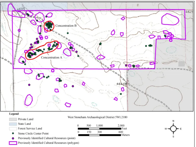
The difficulty with using the previous site boundary information was apparent at 5WL2180, the West Stoneham Archaeological District. Site boundaries had been
established during previous recordings of the area, with each type of resource receiving a separate site boundary and number. This means that stone circles had separate
boundaries from other stone circles and separate boundaries from the lithic scatters and rock shelters also located at the district. Problems occurred when site boundaries for rock shelters and lithic scatters overlapped with those of the stone circles, and each other (Figure 8).
In the case of sites 5WL1840, 5WL1844, and 5WL1991, all of which are located at the western portion of the basin, on the basin floor. The problem was that the stone circles separated into these three sites in fact made a linear distribution of continuous features that are being referred to in this research as Concentration A (Figure 9).
In this instance, the use of individual site boundaries is impractical for management and analysis purposes. For this research, the West Stoneham Archaeological District is being considered one site, 5WL2180, with concentrations of stone circles separated by
landform type. Concentration A is the linear grouping of stone circles on the basin floor and Concentration B is the grouping located on the bench to the north of the basin. The remaining stone circles are scattered throughout the area in smaller groups, on various landform types (Figure 10).
38
39
40
41
These concentrations may be considered by some as separate sites, but the concern with making these concentrations sites is that this basin was used multiple times throughout history and assigning separate boundaries assumes separate occupations when in fact the stones circles within each concentration, as well as between concentrations, are likely from different occupations. The West Stoneham environment is quite different from the majority of the PNG and was likely used as an entire landscape throughout history and, therefore, cannot be divided into individual sites, and hence, it is an appropriate district. Since three sites have already been combined into one large concentration, it does not make sense to create a new site that will be changed in the future when more stone circles are exposed and others are concealed by the changing environment. Considering the entire district as a single site allows for a unit to be managed by the Forest Service and allows for a better analysis of what may have been occurring in this unusual landscape.
Data Collection
Data collection occurred during the summer and fall of 2010 and spring of 2011 using a Trimble GeoXT to collect geographic positioning data. A center point was collected for each stone circle and post-corrected for better accuracy. Multiple attributes were recorded for each stone circle, including the interior and exterior diameters, stone counts for eight sectors (octants) within each circle, gap direction, circle completeness, and circle definition.
The two measurements for each stone circle were taken along the north-south axis and the east-west axis. The interior measurement was taken from the innermost
42
alignment of stones creating the circular geometric shape. Any stones within the interior of the circle, not part of the geometric shape of the feature, were noted but not included in the measurement. The exterior measurement was taken from the outermost stones
associated with the circular geometric shape. In the case of areas where many stones were naturally scattered around, for example near a rock outcropping, then the outer most stone was determined by similar level of sodding in the ground with the other stones in the circle, and no further than 1 meter from the main circular geometric shape. It is possible that stones further than 1 meter out were associated with the feature, but this was meant to provide a good representation of the overall exterior measurement of the feature.
The classification for a gap was taken from the Recordation Standards and
Evaluation Guidelines for Stone Circle Sites: Planning Bulletin No. 22, from the Montana State Historic Preservation Office (MSHPO 2002). A wall gap was classified as “a void between stones, which exceeds roughly 50 cm and is less than 90 degrees of the stone circle” (MSHPO 2002:6). Since this research only deals with the surface expression of the stone circles, it is possible that stones were buried where a gap appeared to be on the surface. To attempt to mitigate this possibility, a pin flag was used to probe the area of the gap to determine if any stones were buried just below the surface. If no stones were struck by the pin flag, then it was determined that the gap was indeed a break in the stone alignment. It is still possible buried stones existed, but this reduced the possibility of the occurrence.
The definition of the circle was also taken into consideration when determining if a gap was present. The definition of the circle refers to how closely spaced the stones are from each other, within the stone circle (MSHPO 2002:6). Good definition, therefore,