AGRO-CLIMATIC RISK AND IRRIGATION NEED OF THE NIL WALA BASIN, SOUTHERN SRI LANKA
K.D.N. Weerasinghe I W.K.B.Elkaduwa2
C.R.Panabokke2
ABSTRACT
Climate potential in respect to onset, magnitude and risk associated with rainfall for crop production in the Nilwala basin, Southern Sri Lanka was assessed using the daily rainfall of 12 stations scattered in different locations for more than 35 consecutive years (1950-1995). The program CROPWATwas used to assess the irrigation need.
It was revealed that rainfall of the basin increases from south to north with increasing elevation and altitude. Within a 70-km distance in the south north gradient, rainfall elevates from 1656 mm at Kekanadura to 4216 mm at Kudawa. The net irrigation requirement ofYala rice in different locations varied from 1012 mm to 1246 mm. It was established that the irrigation need in the Nilwala upper catchment is below 40 % of the total water requirement, but in downstream areas it constitutes above 70% of the total water demand. Therefore both the Yala and Maha seasons in Nilwala downstream areas appeared to be unsuitable for rice cultivation without supplementary irrigation.
From April lOth onward until May 20th is the best period for establishment of perennial crops at upper catchment areas. Optimum dates for crop establishment at the mid and lower part of the catchment falls on the 14th meteorological week. It is important to note that delaying crop establishment in Yala by 2 or 3 weeks from the optimum date would result in a considerable increase of irrigation need even in the upper catchment areas; it is not advisable to delay the establishment of Maha rice until October when rice varieties off our month duration are cultivated.
INTRODUCTION
The Nilwala Ganga watershed is situated entirely in the Matara district, southern Sri Lnaka covering 960 sq. km. The river rises in the vicinity of Deniyaya at an altitude of 1050m and flows into the sea at Matara after traversing nearly 72 km.
I Department of Agricultural Engineering, Faculty of Agriculture, University of Ruhuna, Mapalana, Kamburupitiya.
2 SCORE Project, IWMI, Battaramulla 455
The rainfall of the basin increases from south to north with the increasing elevation and the altitude.
In respect of the rainfall pattern, the Nilwala upper catchment belongs to the wet and ultra-wet zones and the lower basin to the intermediate zone according to the climate classification of Sri Lanka.
There are five physiological regions in the basin; the flood plain (less than 6m above msl), the mantle plain (less than 50 m msl), highland region (50-300m msl) and the mountain region (300-1000 m msl). The climate gradient of the basin varies with the altitude gradient. In respect ofagro-ecology, five agro-ecological zones, namely Wet zone Law country,2 (WL2), Wet zone Low country,4 (WL4), Wet zone Up country ,I (WUl), Intermediate Low country, 2(IL2) and Wet zone Mid country, 1 (WMI) zones are demarcated in the basin according to the agro-ecological map of Sri Lanka.
The present study deals with the rainfall probabilities and climatic water balance of the Nilwala watershed to improve the agronomy of the major crops grown in the basin with a particular emphasis on paddy and tea, which are the major crops grown in the area.
The major objective of the study is to identify optimum cropping calendars and planting times for major crops in different agro-ecological regions of the basin. This includes the ideal time for the commencement oftea and paddy while identifying the critical water deficit periods based on the water balance to provide supplementary irrigation.
When the genetic composition management and soil fertility level are at optimum, the ultimate growth and development of any crop is mainly governed by the weather regime. If a particular crop is considered, the limitation in climatic conditions to achieve high yields vary with the growth stage. Therefore, land use, cropping pattern and production schedules in a given geographical area are influenced by characteristics of rainfall and other climatic factors while influencing the farming operations besides crop growth.
Among climatic parameters in the tropics, rainfall shows the greatest spatial and temporal variations. There for the analysis of agro-c1imatic data in respect of a given amount of rainfall is extremely useful for agricultural operational planning. Studies in Sri Lanka by Pamabokke and Walgama (1974) have closely
demonstrated that the arithmetic mean usually calculated directly from rainfall figures does not take into account the inherent skewness of the raw data that results from a large amount of rain falling in heavy tropical downpours thereby raising the mean level much above the normal amount of rainfall received or expected. Abeyasekara et aI., (1983) have shown that the past attempts to use total or average values of rainfall for identification the best times for crop establishment
Nilwala Basin, Sri Lanka
has many inherent limitations such as lack of information on dry spells, etc. This is because the successful establishment of a crop depends not only on the soil moisture status at the time of planting but also on the length and repetition of dry periods during the crop season. Therefore the recommendations based on mean monthly averages may sometimes be hazardous as shown by OIdeman and Frere (1982).
It is worthwhile to consider the suggestions made by Krishnan (1980) to consider the week as the unit of time in the tropics where the rainfall is highly erratic in intensity, amount and distribution. This helps to take decisions based on the probability of receiving a certain amount of rainfall during a week to select crops and to identify the ideal time of planting while avoiding probable water stress periods and floods during sensitive phenological phases etc. This approach was widely used by Robertson (1976), Virmani (1980), and Virmani et. al., (1982) to characterise the agro-cIimatological potential in different locations.
MATERIALS AND METHODS
Daily rainfall data from 21 rain gauge stations in the Nilwala basin for the period of 1950-1995 were collected from the meteorological department for the analysis. However the continuous data were available for 12 stations (Table 1) which were selected for the analysis. Consistency of the data was assessed by the double mass curve and regression analysis for each pair of stations.
Within the Nilwala basin, actual pan evaporation data for a long period were available only at the university meteorological station, Mapalana. They were used to calculate potential evaporation for the locations situated at the Nilwala downstream.
The available data of average temperature and relative humidity of the Deniyaya station were used to calculate the potential evaporation for Nilwala upper catchment area using the Ivanov's model that has been tested for Sri Lanka in previous studies. (Weerasinghe, 1986)
The computer program "first" (Weerasinghe, Sabatier, Luc, 1990) has been used for rainfall probability assessment based on Markov Chain procedure. The computer programs BIL (developed at IRA T/CIRAD,Montpellier, France, (Franquin and Forest, 1982) and "CROPWAT" were used for computation of water balance and irrigation need.
RESULTS AND DISCUSSION
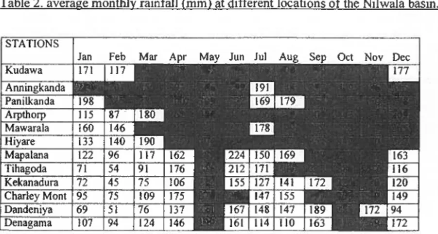
Annual and monthly rainfall statistics of the NIL WALA rainfall: The locations of the rain-gauge stations, mean annual rainfall and the annual rainfall at 75 % probability levels are given in table I.
Table.l location of rain gauge stations and the annual rainfall
Station Database Lati- Longi- Altitude Mean
tude tude (m) Annual
rainfall mm Kudawa 1980 -95 6.28' 80.25' 600 4216 Anninkanda 1951-95 6.35' 80.32' 554 3867 Panilkanda 1951-95 6.22' 80.38' 600 3092 Arpthorp 1985 - 95 6.13' 80.20' 100 3246 Mawarala 1951-94 6.12' 80.35' 200 3041 Hiyare 1951-95 6.05' 80.20' <30 2796 Mapalana 1951- 95 6.03' 80.34' 58 2352 Tihagoda 1951- 95 6.01' 80.34' 50 2041 Kekanadura 1957- 92 5.58' 80.35' <30 1656 Charley 1951-95 5.58' 80.28' 20 2527 Mount Dandeniya 1951-95 6.00' 80.39' 30 1686 Denagama 1951-95 6.06' 80.39' <30 1863
*
Agro-ecologlcal zones as Idenhfied III the Agroecologlcal map# At 75 % probability level De- Zone pen-
*
dable .Rf (mm)# 2829 WUI 2593 WUl 2100 WUl 2172 WMI 2033 WM2 1867 WL2 1567 WL2 1356 WL4 1096 WL4 1685 WL4 1146 IL2 1236 IL2It is evident that the mean annual rainfall in Kudawa, Arpthorp and Anninkanda, exceeds 3810 mm and are in the ultra-wet zone according to the National Atlas ( Agro-Ecology ) of Sri Lanka. Mawarala, Hiyare, Panilkanda, Charley Mount and Mapalana receives greater than 2160 mm of rains, which is typical for the wet-zone. Thihagoda and Kekanadura come under the Wet zone Low country (WL4) according to the agro-ecological map. However with respect to dependable rainfall as well as annual rainfall, these two locations appeared to be much drier and are representative oflL2 zones as in the case of Dandeniya and Denagama stations. Rainfall of the Nilwala basin increases from south to north with the elevation and altitude increase. The topography strongly influences the spatial distribution of rainfall, thus comparatively high rainfall is observed in the Deniyaya region. The dryness prevailing in the eastern part of the area is evident from the rainfall figures of the Dandeniya, Denagama, and Kekanadura stations. It appears that within a 70
Nilwala Basin, Sri Lanka
(Kekanadura) to 4216 mm (Kudawa) and in a west -east gradient rainfall decreases from 2527mm (Charley Mount) to 1686 mm (at Dandeniya). The dominant characteristics of the rainfall in all the locations are the bimodal rainfall distribution with two dry periods, one at January-February and second at July- August. Thus the rainfall pattern may be conveniently discussed in terms of Yala and Maha rains.
The rainfall year could be differentiated in to following cycles based on the types of rains received during the Yala and Maha seasons.
Months Yala season Months
March - April Convectional rains Oct.-Nov.
May - Sept South-west Monsoon Dec.-Feb.
Maha season
Convectional rains North-east Monsoon Table 2 indicates the average monthly rainfall at the different locations. According to Oldeman's (1980) criteria, wet months for rice would be a month with more than 200 mm rains and there should be at least three consecutive wet months in the season to cultivate wetland rice without irrigation. As experience reveals, the criteria of200 mm may hold true for fluvial rice; it can be less for phreatic rice lands where lateral seepage of ground water occurs in areas such as the upper Nilwala catchment. Nevertheless water requirement for dryland crops could be met with an average monthly precipitation of about 90 mm. (Oldeman, 1980). Table 2. average monthly rainfall (mm) at different locations of the Nilwala basin.
It is evident from table 2 that in the upper Nilwala regions, the number of wet months with more than 200 mm in the annual cycle is 9-10 months and towards the flood plain, the number of wet months becomes considerably less. For instances, in Mapalana and Thihagoda, there are only 2 wet months in the Yala
season and 3 to 4 wet months in the Maha season. Both Yala and Maha seasons in Dandeniya and Denagama seem to be not suitable for rice cultivation without supplementary irrigation. Minor tanks in the Nilwala basin are concentrated in WL2, WL4, IL I, and IL2 agro-ecological regions, which is a clear indication of the historical acceptance of irrigation water requirement in these areas, where rice could not be grown without supplementary irrigation.
Initial probability of rainfall: In a growing season of a given crop, a decision has to be made many times based on the probability of receiving certain amount of rainfall during a given week. A weekly rainfall of 10 rom at 75 % probability is considered in the present work as the sufficient level to satisfy the moisture requirement ofthe crops in three out offour years. This criterion is adopted by many authors in demarcating the wet and dry periods (Virrnani 1976, Virmani et al
1982, 01deman 1980) .
Commencement of the Yala and Maha seasons in respect to the 10 mm rainfall limit at 75% probability at different locations are highlighted in the table 3. It is evident that the loth to 50th meteorological weeks are wet in Kudawa. In Anninkanda, wet weeks in Yala and Maha seasons fall during the 9th to 29th and 35th to 520d weeks. It is evident that the duration of the Yala season as well as Maha season is much shorter in Nilwala downstream and in the flood plain. It is worth noting the prevailing dryness in Denagama, Dandeniya, Thihagoda
Kekenadura compared to Mapalana in both Yala and Maha seasons.
Optimum cropping calendar and planting time of rice: The optimum cropping calendar and planting time based on the water balance, calculated by
"CROPWAT" for the rice in Yala and Maha seasons are given in tables 4 and 5. The optimum date of crop commencement was simulated by changing the date of planting and assessing the irrigation requirement. When cropping date is changed, the irrigation requirement is also changed, so the optimum date of planting was selected on the basis of the least irrigation requirement.
Nilwala Basin, Sri Lanka 461
Table 3 Initial probability of weekly rains (Limit 10 mm)
.>< 0: - ~
..:
'"
~"
0. -0 .:. -0"
Os, OJ"
o§ ·c"
e.
~'"
"
Q. <II :"'"
c'"
g"
~" '"
c""
Co ~ .~"
"
.c -5 OJ E .c'" "
·c OJ 5 :.: ~ ...:'" '"
c -< 5e
::r: ::E c i= :.: u .!1 0 0 .>< Q.."
"
0"
"
"
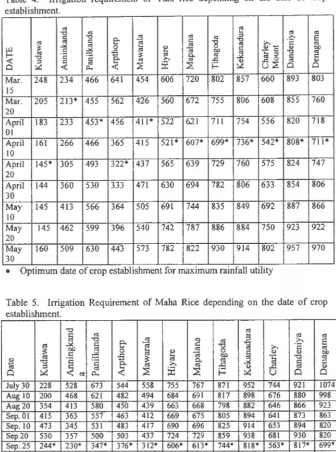
Table 4. Irrigation requirement of Yala rice depending on the date of crop establishment
'"
r:
"0 ~'"
'"
c os'"
'"
'"
>. ~'"
'"
ce-
~ c"8
"0 ~ ....'c
.>0:'"
'"
os""
~ c ~ 0'"
2:! 0; c II) b/)~
b/) _ c f-'"
'
c
~'"
c..'"
os:a '"
"0'"
"0'
ij
>. .>0: c c«
'"
c'"
'"
..c ~ ..c 0'"
II) Cl ::.G«
CI..«
~:E
~ i= u~ Cl Cl Mar. 248 234 466 641 454 606 720 802 857 660 893 S03 15 Mar. 205 213· 455 562 426 560 672 755 806 608 S55 760 20 April 183 233 453· 456 411· 522 6.21 711 754 556 820 718 01 April 161 266 466 365 415 521· 607· 699· 736· 542· SOS· 711· 10 April 145· 305 493 322· 437 565 639 729 760 575 824 747 20 April 144 360 530 333 471 630 694 782 806 633 854 806 30 May 145 413 566 364 505 691 744 835 849 692 S87 S66 \0 May 145 462 599 396 540 742 7S7 S86 884 750 923 922 20 May 160 509 630 443 573 782 822 930 914 802 957 970 30..
• Optimum date of crop establIshment for maximum raInfall utilityTable 5. Irrigation Requirement of Maha Rice depending on the date of crop establishment.
"0 til
§ "0 til .... til til
eo
~
til.a
::s >.e
~
~~
§-g
>. '2 OIl 0 til~
0 tilJ
til..g
tti OIlla
v v OIlB "0 .~
~
]
]
til~
>. c.. ] ~ c:<IS ::s <IS II) II)
0 ~ t:I. ~
:I:
~ ~ ~ U 0 0 July 30 228 528 673 544 558 755 767 871 952 744 921 1074 Aug 10 200 468 621 482 494 684 691 817 898 676 880 998 Aug 20 354 413 580 450 439 663 668 798 882 646 866 923 Sep.OI 415 363 557 463 412 669 675 805 894 641 873 863 Sep. 10 473 345 531 483 417 690 696 825 914 653 894 820 Sep20 530 357 500 503 437 724 729 859 938 681 930 820 Sep.25 244· 230· 347- 376· 312" 606- 613· 744· 818· 563- 817· 699· Sep.30 592 389 465 532 474 770 773 905 969 724 974 843Nilwala Basin, Sri Lanka
It is evident from table 4 that the optimum date for crop establishment at Kudawa
falls on April 20th, since there would be sufficient rainfall until the 2nd week of
August to meet the crop water demand. However it is worth noting that from
April 10th onward until May 20th is the best period for crop as establishment at
Kudawa. Analogically, dates for crop establishment at Nilwala upper catchment
areas fall on March 20th at Anninkanda, April 1 sl at Paninkanda, April 20th at
Arpthorp and April 1 sl at Mawarala areas.
The optimum dates for crop establishment at the mid and lower part of the
catchment fallon 10th April. However it is worth noting the increment of irrigation
water requirement in these areas compared to the upper catchment areas due to the prevailing dryness in lower and mid areas of the catchment.
In respect to the crop establishment in Yala season, one should keep in mind that delaying it by 2 or 3 weeks from the optimum date would result in a considerable
increase of irrigation water need even in the upper catchment areas. Therefor, it is
important to assure the establishment of the Yala crop before the Sinhala-Tamil New Year. This is the actual practice accepted by the farmers as experienced in many locations ofthe Nilwala areas and reported by Elkaduwa in 1997.
Optimum planting time for rice in Maha season.: It is evident from table 5 that
Sep 25th is the optimum date of crop establishment for the Maha rice. This agrees
with the results of the survey conducted by Elkaduwa ( 1997), by interviewing the
farmers in the Nilwala upper catchment areas. According to the farmer's
experience, the best period for crop establishment in Yala falls on April 10th and
Maha in the latter part of the September.
It is evident that delay of cropping date beyond September 25th will result with
the increase of irrigation water demand. Delay of the crop establishment will increase the water demand in January and February which are very dry at all the
locations. As such it is not recommended to delay the crop until October when
four-month varieties are cultivated.
Irrigation Reguirement of Rice: Total water requirement, effective rainfall and the
percentage irrigation demand from the total water need during the Yala and Maha
seasons in different locations are given in tables 6 and 7.
In general the total water requirement of the Yala crop varies from 1012 - 1457 mm in different locations which agrees with the crop water need of rice under prevailing climatological situations in Nilwala areas. The irrigation requirement increases in the drier part of the Nilwala areas, which is associated with a decrease
in effective rainfall. It is evident that irrigation need is below 40% in the Nilwala
upper catchment, but it is considerably increases in the drier part. When the irrigation requirement exceeds 50% of the total, the risk will be very high. As indicated by the data, Dandeniya and Denagama have very high irrigation water
demand, which constitutes above 70% of the total water demand. As such, rice in those areas cannot be cultivated if irrigation facilities are not provided.
Table.6 Effective rainfall and Irrigation water requirement of rice during the Yala season
Station Total water Effective Irrigation Percentage requirement rainfall requirement irrigation
requirement Kudawa 1457 1293 164 11,25 Anningkanda 1085 872 213 19.63 Panilkanda 1042 589 453 43.47 Arpthorp 1070 748 322 30.09 Mawarala 1042 631 411 39.44 Hiyare 1016 494 521 20.22 Mapalana 1014 407 607 59.86 Tihagoda 1012 313 699 69.07 Kekanadura 1013 277 736 50.18 Charley Mount 1015 473 542 53.40 Dandeniya 1061 253 808 76.15 Denagama 1013 302 711 70.19
Table.7 Effective rainfall and irrigation water requirement of rice during the Maha season.
Station Total water Effective Irrigation Percentage requirement rainfall requirement irrigation
requirement Kudawa 1262 1018 244 19.38 Anningkanda 1175 945 230 19.5 Panilkanda 1042 695 347 33.33 Arpthorp 1201 825 376 31.30 Mawarala 1078 767 312 28.94 Hiyare 1143 537 606 53.01 Mapalana 1148 535 613 53.39 Tihagoda 1012 313 699 69.07 Kekanadura 1157 339 818 70.70 Charleymount 1148 584 563 49.04 Dandeniya 1155 338 817 70.73 Denagama 1163 464 699 60.01
Planting dates and irrigation requirement oftea and perennial crops: The most suitable dates for planting tea in the Nilwala areas based on the water balance is given in fig. 1 (a,b)
Nilwala Basin, Sri Lanka
,---
Irrigation requirelDcat ofTe. depending on the date of crop co", .. entemcot(Nih.ala upstream) I J E .! 0::
"
;:..
..
~ FI~u",,_ I <a)Irrigation Requirement (mm) Yala
300 r---,----r--~--~----,_--,_--_r--_.--_,,_--~--~--,
I-~-t
·I-t·
t-
L
-
+
--T---~,---r--~--t--
---:
250 200 150 100 SO 0 ---+----''''-<-+----I---'''-L---i---+--. i i ,;
I
1
0!
'"
C! :2 0 :2~
:2 0 :2 0 ~ ~ .D -<i :;j :;j~
,:, ,:, c c .l! .l! :::e ::;: -( ::;:..
:::e..
~ ~ Date ~--+-
Th~d3;;"'·---.---
-+.-
Ma-",,-r-ala--- - -___ Hiy.re ----___ Anilkanda ___ Paninkanda _ _ Arplhorp _ _ _ _ _ _ _ _ _ - - - 1
-- - - - -- -- --
---.
r
----·----
--+-Tlulawa---l
-+-Mlwnla -+-~'--
__
-:!"Ari~~ ____~Parincarm ____ -::!:":~.J.--
-I
450 400 350 300I
i
250I
t
200 ISO I I 100 I 50 0 ~ :;...
Irrigalion ... qui ... meot ofTe. depending on lhe dale of crop commencemenl (Nilwa .. dowDSlream)
Fog ... I (b)
Irrigalion RequiremeDI (mm) Yal.
i
.
-+
I
: - I I -T 1-
(..-
,
I
i
T
i
-J
- - --1---i
~-
-t--l--
-:-~ c:l..
...
=> ~ ~ ~ ;; ~ => ~ => .ci .ci .: .: .: ~ ~ c:l.::: .::: ::i!
..
::i!..
«...
«...
::i!..
~...
..
Dlle
~--=;:.::-Mapalana ----~ TIhagoda - . . - Denagama
___ Daodeniya ___ Krkanadura - . . - Char1y Mounl
' -_ _ _ _ , • ...1...-- _ _ _ __ _ • _ _
r
hrigaIioa ....-me .. ofT .. "'....-.: ... dale of CropCOllllr""""""
( l ' h a I a - " " Rgwe.1 (b) hrigaIioa R£ ... me .. ( ... ~_ ~ c:l
"
...
---
I
4~r---'---r--r---r--.---,----~---~---' 400 ~ _ _+-_-.:.._
_
1_ ~ r 350 ~ E 300 I~ ~
=-j
.g :ml.
t
I~
j--=-..J----"'l ... rl 100 1---1--" .... . ~ o~-l__
~~~~~~~__
J-~__
~__
~~~ ~ ;:; ~ ;:; ~ ;:; ::£ 0 ::£ ;:; ~ ~ ~ .ci ~i
5. ~ ~"
~ c .1! 00( ..: ::;: ~ ~ DII.l
-+-MIpoIare"
.. - -'---
-
~--
TII1IIJlda -.-OInbi)'l ___ KdanWa .-
- - - - -~-- --Nilwala Basin, Sri Lanka
The water balance is calculated using the program CROPWAT considering the requirement of a wet period for 120 days for the crop to establish the root system. Rooting depth was considered as 45 em at the planting time and 60 em at the latter stages. The accepted soil moisture depletion level was taken as 75%.
Results of the simulation revealed that there wiII be no irrigation requirement if the planting was done during March 15th to May 15th in Kudawa, Anningkanda, Panilkanda and Mawarala. However in Arpthorp the suitable period falls within April15th to May 15th. It is not advisable to delay the planting date beyond May 15th in all the locations of the Nilwala upper and mid catchment areas. However in Hiyara the best time for planting would be around March 15th with an irrigation requirement of about 75 mm.
For most of the locations in the Nilwala upper and mid catchment areas, establishment of the crop in Maha seems to be not advisable due to the dry spells in January-February. However at Kudawa, Paningkanda and Anningkanda the crop may be established during Sep 1st - October 1st. (Fig.l a)
In the flood plain and the lower regions of the Nilwala river, the best crop establishment period with least irrigation water requirement falls during the mid-August to mid-September. If the crop could be established during this period, the irrigation requirement prior to root establishment will be low.
From the water balance point of view, it could be concluded that the best period for crop establishment in the Nilwala upper and mid catchment areas falls before May 15th• In the lower flood plain, it falls before September 15th.
CONCLUSIONS
Rainfall of the Nilwala basin increases from south to north with the increasing elevation and altitude. The topography strongly influences the spatial distribution of rainfall and comparatively high rainfall is observed in the head waters of the Nilwala river at Deniyaya region. Within a 70 km distance in the south north gradient, rainfall elevates from 1656 mm (at Kekanadura) to 4216mm (at Kudawa). In the west east gradient, rainfall decreases from 2527 mm at Charley Mount to 1686 mm at Deniyaya.
The upper mountainous region of the Nilwala basin has 9-10 months with more than 200 mm monthly rains in the annual cycle where high probabilities exist to receive more than 200 mm monthly rain during both the Yala and Maha seasons. During both the Yala and Maha seasons in Nilwala, the downstream areas seem to be unsuitable for rice cultivation without supplementary irrigation. Minor tanks for irrigation purposes in the Nilwala basin are concentrated in WL2, WL4, Ill, and
IL2 agroecological regions, which is a clear indication of the historical acceptance of the necessity for irrigation in the downstream areas.
From April lOth onward until May 20th seems to be the best period for establishment of crops at the Nilwala upper catchment areas. Optimum time for establishment of rice falls on March 20th at Anningkanda, April 0151 at Panilkanda, April 20th at Arpthorp, and April 151
at Mawarala. Optimum dates for crop establishment at the mid and lower part of the catchment falls on April lOth.
In respect to the crop establishment in the Yala season, it is important to note that delaying it by 2 or 3 weeks from the optimum date would result in a considerable increases in irrigation water need even in the upper catchment areas. Therefore it is important to assure the establishment of the Yala crop before the Sinhala-Tamil New Year.
This·is the actual method practised by farmers as experienced in many locations of the Nilwala areas. With respect to the Maha season, it is not advisable to delay the establishment of crop till October when four month varieties are cultivated.
The total water requirement of Yala rice varies from 1012 to 1267 mm in different locations of the Nilwala basin. The irrigation requirement increases in the flood plain, which is associated with a decrease in effective rainfall. Deniyaya and Denagama have a very high irrigation demand, which constitutes above 70% of the total water requirement. As such, these are high-risk areas of the Nilwala basin for rice production.
There will be no irrigation requirement for tea and other perennial crops ifthe planting is practised during March 151h to May 15th in Nilwala upper and mid catchment areas. Establishment of tea in Maha seems to be not advisable due to the dry spells falling on the January and February months. However, at Kudawa, Panilkanda and Anningkanda tea may be established during September 151 to October 151
of the Maha season.
ACKNOWLEDGEMENT
Technical Assistance offered by Mr. C.P. Gunasena in data analysis and preparation of this paper is greatly acknowledged.
REFERENCES
Abeyasekara 6. Senviratne E.K., Leaker A. and Stem R.D (1983) The analysis of daily rainfall for Agricultural purposes. J.Nat.Sci.Coun.Sri Lanka II (No 1 )
Nihvala Basin, Sri Lanka
Elkaduwa W.K.B, (1997), Analysis of Agro-Climatic data of the Nilwala basin in relation to irrigation agronomy, SCORE Project, IIMI, Unpublished data. Franquin A.Forest F. (1982) Des programmes pour I' evaluation et I' analyse frequentielle des terrnes du bilan hydrique. Agro Trop XXXII - I
Krishnan A. (1980) Agro climatic Classification methods and their application to India, Climate Classification. A Consultants meeting ICRISAT, India.
Oldeman L.R. (1980) The Agro Climatic Classification of Rice growing environment in Indonesia. Proc. Symp. Agro climatology of the Rice crop, IRRI, Philippines.
Oldeman L.R. and Frere M. (1982) A study of the Agro Climatology of the humid tropics of South East Asia. FAOIUNESCO/WMO inter agency project on Agro climatology. Technical note 179,WMO, Geneva.
Panabokke C.R. and Walgama A (1974) The application of rainfall confidence limits to crop water requirement in dry zone agriculture in Sri Lanka.
J.Natn.Sci.Coun.Sri Lanka 2 (2).
Roberston G.W. (1976) Dry and Wet spells. Tun.Razak. Agric. Res. Centre. Sung, Tekam, Malayasia project final report: Agro Meteorology A-615.
Virrnani S.M. (1976) The Agricultural climate of the Hyderabad region in relation to crop planning. A sample analysis. ICRISAT, India.
Virrnani S.M (1980) Need relevance and objectives of the consultants meeting on climate classification; A consultants meeting ICRISAT, India.
Virrnani S.M. Sivakumar M.V.K. and Reddy SJ. (1982) Rainfall probability estimates for selected locations of semi arid India; Research report, ICRISAT India.
Weerasinghe K.D.N. Comparative study of temperature based equations in estimation of potential evaporation for Angunukolapelessa in the arid zone of southern Sri Lanka. J.Natn. Sci. Coun. Sri Lanka, 1986 14 (1) : 75-82.
Weerasinghe K.D.N., Sabatier J.L. and Grandgean Luc (1990) Manual for FIRST; A computer program for Agro climatological data analysis, Users manual, University of Ruhuna, Matara, Sri Lanka.