SKI Report 91:8
Research
The Potential Significance of Permafrost to
the Behaviour of a Deep Radioactive
Waste Repository
Tim McEwen
Ghislain de Marsily
February 1991
THE POTENTIAL SIGNIFICANCE OF PERMAFROST TO THE BEHAVIOUR OF A DEEP RADIOACTIVE WASTE REPOSITORY
TimMcEwen Ghislain de Marsily SKI TR 91:8
Intera, Melton Mowbray, UK
and U niversite de Paris VI
February 1991
This report concerns a study which has been conducted for the Swedish Nuclear Power Inspectorate (SKI). The conclusions and viewpoints presented in the report are those of the authors, and do not necessarily coincide with those of the SKI. The results will subsequently be used in the formulation of the Inspectorate's Policy, but the views in this report will not necessarily represent this policy.
Contents
1 Introduction
2 Di.stribution of permafrost
2.1 Introduction . . . . 2.2 Properties of frozen ground
3 The hydrogeology of permafrost areas 3.1 Introduction . . . . 3.2 Position of "aquifers" relative to permafrost
3.2.1 Introduction . . . .
3.2.2 Suprapermafrost Aquifers 3.2.3 Intrapermafrost Aquifers
3.2.4 Subpermafrost Aquifers
4 Groundwater movement 4.1 Infiltration and recharge 4.2 Lateral movement .
4.3 Discharge . . . . . 4.3.1 Introduction.
4.3.2 Springs.
4.3.3 Baseflow
4.3.4 Icings (Naledi or Aufeis)
5 Geochemistry
5.1 Effects of low temperatures
5.2 Groundwater geochemistry 5.3 Chemistry of Icings . . . . 1 3 3 5 6 6 6 6 9 10 11 12 12 13 14 14 15 15 15 16 16 16 18
5.4 Surface water chemistry . . . 18
6 Water supply in permafrost areas 18
6.1 Introduction... 18
6.2 Surface water supplies 19
6.3 Groundwater supplies. 19
6.4 Natural factors which effect the hydro geology of permafrost terrains. . . .. 20
7 Future climatic states over the next million years 21
8 Permafrost behaviour around a repository 25 8.1 Statement of the thermal problem . . . 26
8.2 Assumptions made in calculating the effect of the repository 27 8.3 R e s u l t s . . . 31
9 The significance of permafrost on the performance of a
repository 43
9.1 Introduction 43
9.2 The effect of permafrost on groundwater infiltration and recharge . . . 43
9.3 The effect of permafrost on discharge 46
9.4 Lateral groundwater flow . . . 47
9.5 The effect of permafrost on the chemistry of the groundwater 47
9.6 The influence of permafrost on the release of gas from a repository, and on the formation of clathrates (gas hydrates). 49
9.6.1 Introduction. 9.6.2 Clathrates 9.6.3 Discussion 49 50 53
9.7 The influence of permafrost on the repository engineered barriers . . . 53
9.8 The influence of permafrost on the biosphere 55
10 Permafrost scenarios 56
10.1 Introduction . . . . 56
10.2 Radionuclide release via springs 56
10.3 Release via a sub-lacustrine open talik 58
lOA The combination of thermal buoyancy combined with a sub-lacustrine open talik .. . . .. 59
10.5 The combination of thermal buoyancy, together with shaft seal failure and a sub-lacustrine talik . . . .. 59
11 Structure of scenario to be analysed 59
12 Recommendations for repository designs 61 12.1 Aspects of repository design and location influenced by
per-mafrost . . . 61
References 63
List of Tables
Introduction
Permafrost is one of the scenarios that is being considered as part of the groundwater flow and transport modelling for the Project-90 assessment.
It is included as one of the primary Features, Events and Processes (FEPs) which are being kept outside the PROCESS SYSTEM in the SKBjSKI scenario development project (Andersson at aI, 1989). There is a large amount of evidence that Sweden has suffered several cycles of permafrost development over the Quaternary, approximately the last 2My, and cli-matic predictions for the next hundred thousand years suggest that sim-ilar climatic cycling is likely to occur. The presence of permafrost could have important effects on the hydrogeological regime and could there-fore be important in modifying the release and dispersion of radionuclides from a repository. The climatic conditions of permafrost would also in-fluence radionuclide migration and accumulation in the biosphere and the associated radiation exposure of man. These biosphere aspects are not considered here but the implications for discharge into the biosphere are examined, including the abstraction of groundwater by man in permafrost regIOns.
In order to structure the list of FEPs, it was found necessary to introduce the concepts of the PROCESS SYSTEM and external conditions. The PROCESS SYSTEM comprises the complete set of deterministic physical and chemical processes that might influence the release of radionuclides from the repository to the biosphere. The external conditions are events and processes that are not induced by the repository and can occur in-dependently of the processes in the PROCESS SYSTEM. Using these definitions, most of the FEPs on the original list were assigned to the PROCESS SYSTEM. and only a small number, approximately 50, were left as FEPs representing external conditions. These remaining FEPs have been grouped (lumped) into a few (10) primary FEPs of external condi-tions, permafrost being one of these ten. This report reviews the evidence relating to permafrost development and discusses the possible implications for the long-term safety of a deep repository.
Continuous permafrost is present to great depths in the Spitzbergen area and in Siberia, and although there is currently no such development of continuous permafrost within Sweden, except in some mountainous areas, it is highly probable that permafrost will be developed, probably repeat-edly, within the next few tens and hundreds of thousands of years.
Permafrost can have a major influence on the recharge and discharge of groundwater, and could be significant in localising the return of radionu-clides to the environment. Permafrost can produce changes in
ground-water chemistry and result in the formation of very saline groundground-waters, especially at the base of the permafrost zone, and this could be significant in radionuclide migration. In addition, depending on the depth of the permafrost, the repository structure itself could be affected. Calculations demonstrate that if the glacial period is of sufficient length, permafrost could, in theory, develop to depths in excess of 500m, though such a possi-bility is thought to be extremely improbable. What seems more probable is that permafrost could affect engineered barriers within the shafts to depths of up to 200m, and this in turn could be significant in increasing the potential for shaft seal failure.
It is likely that one, and perhaps several, periods of permafrost will develop during the thermal phase of the repository. In this situation it might be thought that the rock above the repository would remain unfrozen, whilst the surrounding rock would freeze. The resulting concentration of the thermally driven advection in the rock immediately above the repository could then result in very much shorter transit times to the surface, and these times could be further reduced in the event of any failure of the shaft seals, especially if the shaft is direc~ly above or close to the repository. It
will be argued that this situation is in fact very unlikely to occur, except in special circumstances which, if the site is chosen accordingly, can be avoided.
Permafrost may result in a concentration of radionuclides in the ground-water beneath, or within, the permafrost zone, which may subsequently be released as a concentrated pulse when thawing takes place. The geochem-istry of ground waters that may transport radionuclides CQuld be substan-tially modified after long periods of permafrost, with the presence of higher concentrations of complexing species. Gases derived from deeper within the rock mass may become frozen as clathrates within the permafrost zone or may be trapped as a gaseous phase beneath the permafrost. Gas accu-mulation could lead to enforced outflow of groundwater from the repos-itory, though this is thought to be of minor significance. The influence of any gas cushion on the groundwater flow field is considered possibly more important. Clathrates are not normally found in crystalline rocks and their significance is not at all clear in the context of a repository for spent fuel.
Permafrost has a major effect on the biosphere, and hence on the types of communities that may be present above the repository. The reduced volumes of potable groundwater that are available in areas of continu-ous permafrost preclude the development of large communities, except in the situation found in Siberia, where major rivers which have their head-waters south of the permafrost continue to flow through the permafrost zone. On the other hand, the location of any community is most likely to
2
2.1
be in an area of discharging groundwater, which is more likely to be where any radionuclides from a repository would be released to the environment. Permafrost could result in more concentrated or localised release to the biosphere. The scope for this to occur in the Swedish case will be exam-ined along with some outline discussion of the implications of this more localised release for predictions of radiation dose.
This report is divided into two main sections. The first is a summary of the nature of the permafrost environment, describing factors that would need to be taken into account in a repository performance assessment. The second endeavours to construct a number of scenarios which are thought to be those of most significance to the release of radionuclides from the repository and the subsequent transport through the geosphere to the biosphere.
Distribution of permafrost
Introduction
Permafrost is defined as ground, soil or rock, with temperatures which remain continuously below O°C for two or more years. It occurs in areas with mean annual air temperatures below O°C and is generally overlain by an active layer, which is subject to seasonal freezing and thawing. The occurrence of permafrost is controlled by the surface heat balance, which in turn is influenced by the properties of the ground surface, such as relief, slope aspects, vegetation, snow cover, moisture content, soil and rock type and the presence of surface water bodies (Brown, 1970). Kersten (1959) has derived an empirical formula relating the depth of frost penetration to the square root of the number of days per year with air temperatures below 1.6°C. Locally, moving groundwater can have a significant influence on its development. Near the margins of a permafrost area the permafrost consists of thin, isolated masses and, in the northern hemisphere where most of the current information is derived, is more likely to be present under north facing slopes with thin winter snow cover. Towards the north, the areas in which permafrost occurs gradually become larger, and the depth to the base of the permafrost can increase to depths in excess of 500m at high latitudes.
Sloan and van Everdingen (1988) have defined four zones of permafrost of increasing thickness and persistence. The first zone comprises areas not perennially frozen, but which lie within the permafrost region. In the second zone, individual islands of permafrost do not exceed 15m in depth. Because the permafrost is thin and ground temperatures are close to O°C,
it is particularly susceptible to degradation and aggradation, and it may disappear over a periods of a few decades. In the third zone of discontin-uous permafrost the thicknesses do not exceed 35m. U nfrozen areas are present, but frozen ground predominates, and is older and more stable than that within the second zone. The fourth zone contains continuous permafrost, except where it is absent within taliks (see below).
The length of time during which intense periglacial conditions have pre-vailed is as significant as the increase in latitude. Great thicknesses of permafrost found in the fourth zone require several tens of thousands, and perhaps as much as a hundred thousand years, to develop. Conse-quently, maximum thicknesses will only be found where former ice sheets did not provide an insulating cover from cold air (Ives, 1974). In some parts of arctic North America present day permafrost is thickest where ice sheets were absent during the last (Wisconsin) glaciation, and that in the Mackenzie delta of northern Canada is older that 40ka (Washburn, 1980). Much of this review is based on work carried out in Canada and Alaska, which itself draws on a larger amount of research in Siberia where ex-tremely large areas of continuous and discontinuous permafrost are present in areas that support large populations. The relatively recent increase in mining and oil development has resulted in an increased interest in the properties of permafrost. Data have also been taken from a review of geomorphological processes likely to occur in Britain in periglacial times (Pitty, 1988).
The hydro geological aspects of permafrost have been summarised in pa-pers by van Everdingen (1987) and Sloan and van Everdingen (1988). One problem in using these reviews is that they describe the situation in areas within northern Canada and Alaska, which, although at similar latitudes to central Sweden, have far more marked continental climates. It is dif-ficult to make universal generalisations about permafrost development, as each of these areas has distinct regional characteristics. The north of inland Yukon, for example, has remained largely unglaciated throughout Quaternary times. The possible persistence of permafrost over this period contrasts sharply with the repeated cyclic changes involving glaciation, periglaciation and temperate interglacial conditions experienced in west-ern and north-central Europe. Lapland and Spitzbergen, for example, have mean annual temperatures 6-10°C higher than other regions of the same latitude due to the ameliorating affects of the North Atlantic Drift.
2.2
Properties of frozen ground
When water bearing soil or rock is frozen a number of its physical prop-erties are changed. Electrical and hydraulic conductivities decrease by several orders of magnitude, apparent specific heat capacities decrease and thermal conductivities increase (Anderson and Morgenstern, 1973). Any water remaining in the liquid phase, due probably to the depression of its freezing point by the concentration of its dissolved constituents, will have an increased viscosity. Permafrost, which is defined solely on the basis of temperature, is not necessarily frozen. It may be dry and contain no ice or water. It may contain only unfrozen water; if the freezing point depression is large enough to prevent freezing it may contain a mixture of unfrozen water and ice or it may contain ice exclusively. The ice may be - segregated into lenses, layers or, perhaps, ice wedges.
Unfrozen water can exist in many soils and rocks as thin films adsorbed onto the surface of soil or mineral particles, even when the temperature is well below the initial freezing point of the water (Anderson and Morgen-stern, 1973). The thickness of the water films is a function of temperature and is almost independent of the total water content, except in very dry soils.
The term cryopeg describes zones in which the temperature is <O°C in which all the water is in the liquid phase. Cryopegs are common features in permafrost and in many places a cryopeg is found immediately above the permafrost base (Tolstikhin and Tolstikhin, 1974, van Everdingen, 1976) (Fig 1).
Frozen ground is not necessarily impermeable, although the formation of ice in pore spaces and fractures and in the form of ice lenses, will signifi-cantly reduce its hydraulic conductivity. Freezing of clean, coarse-grained sediments and fractured basement is likely to reduce their hydraulic con-ductivities to a small fraction of their unfrozen values. Freezing of fine-grained sediments with a high clay content may result in only a minor re-duction in their hydraulic conductivity, especially if the temperature falls only slightly below O°C, due in part to the fact that they already possess relatively low hydraulic conductivities. The formation of cracks, caused either by drying or by thermal contraction during periods of extremely cold weather, can significantly increase the bulk hydraulic conductivity of frozen ground, though this tends to be important only within the ac-tive layer. Permafrost will affect the hydraulic regime only if the ground is perennially frozen and its hydraulic conductivity is significantly lower than it would be under unfrozen conditions. Hydraulic conductivities of frozen and unfrozen parts of the same unsaturated ground may be similar
3
3.1
when ground temperatures are close to
aoc.
'With decreasing tempera-tures belowaoc
the hydraulic conductivity of the ground decreases as the cross-sectional area of interconnected films of unfrozen water become progressively smaller. Fracture systems can provide significant additional hydraulic conductivity to the frozen rock mass, whilst the presence of seg-regated ice, as layers and lenses, may decrease the hydraulic conductivity to the point where the ground acts as though it were frozen, with a marked reduction in its hydraulic conductivity ..The hydrogeology of permafrost areas
Introduction
The hydrogeology of permafrost areas is not very well understood and recent advances in this understanding have only been made because of in-creased development in areas such as Alaska, northern Canada and Siberia. For large parts of such regions the knowledge of the hydrogeology is con-fined to observations of ground water discharge phenomena, observations of karst recharge and data on a small number of shallow wells distributed over a very large area (Zenone and Anderson, 1978; Heath, 1984; Michel and Wilson, 1988). The directions and rates of groundwater flow in the permafrost areas are generally dependent on the same physical parame-ters as in areas without permafrost. In addition, however, groundwater regimes in permafrost are affected by major climatic effects and by the presence of perennially frozen ground.
3.2
Position of "aquifers" relative to permafrost
3.2.1 Introduction
The terminology used to describe the hydrogeology of permafrost regions has been developed in response to the demands of groundwater supply and the geotechnical problems associated with civil engineering opera-tions in permafrost (vVilliams, 1965; van Everdingen, 1976) and the same terminology has been used in this review. The term "aquifer", which is used throughout the following description of permafrost hydrogeology, is not commonly used to describe the hydrogeological situation in crystalline basement. It is used here in its general sense, and is not meant to imply zones of the rock mass having higher hydraulic conductivity nor those providing economic groundwater resources.
ACTIVE LAYER
SUBPERMAFROST AQUIFER (T> O'C)
TIlERMAL SPRING
SUBPERMAFROSTAQUlFER (T> ere)
SUBPERMAFROSTAQUlFER(T> O'C)
A
~~t~r/t~j EXPLANATION Se880nally frozen (active layer)D
Unfro7£n PermafrostEn
Frozen Permafr08tD
Nonpermafros[c
Figure 1: Aquifers and water conditions in permafrost areas. A. Suprap-ermafrost: active layer; closed taliks. B. IntrapSuprap-ermafrost: open taliks (lake, river, hydrothermal, hydrochemical); lateral taliks; transient iso-lated taliks; isoiso-lated, marine and basal cryopegs. C. Subpermafrost. (From Sloan and van Everdingen, 1988)
It is convenient to group aquifers under three main headings when dis-cussing the hydro geology of the permafrost region (van Everdingen, 1976j Sloan and van Everdingen, 1988):
1. Suprapermafrost Aquifers - situated above the permafrost, with per-mafrost generally acting as a relatively impermeable lower boundary 2. Intrapermafrost Aquifers - those found in unfrozen zones (taliks)
within the permafrost, and
3. Subpermafrost Aquifers - situated below the permafrost, with per-mafrost acting as a relatively impermeable upper boundary.
These three types of aquifer are variously interconnected as well as con-nected to lakes and streams, and each type can be found in both superfi-cial and recent sediments as well as in basement rocks (Fig 1, from Sloan and van Everdingen (1988)). The presence, or absence, of these different types of aquifers could have a major influence on the potential release of radionuclides from a repository.
The different types of talik, several of which are shown in Fig 1, are de-scribed below, using the suggested definitions of van Everdingen (1976). Several of them are in fact different types of spring and therefore are of particular significance to the release of radionuclides to the biosphere:
(a) Thermal taliks are noncryotic (ie. T>ODC). They include the sea-sonal thermal talik above the permafrost, also known as the active layer, as well as a number of taliks that all contain suprapermafrost water, and the perennial thermal talik below the permafrost, which contains subpermafrost water. In a few cases a perennial thermal talik may be present between the seasonally cryotic layer and the permafrost.
(b) Hydrothermal taliks are also noncryoticj heat from flowing ground-water, often within fracture zones, helps maintain their positive tem-perature. They contain intrapermafrost water and may be fed by either suprapermafrost water (recharge) or by subpermafrost water (discharge). The recharge type is probably seasonal, and many large rivers in northern Canada, eg the Mackenzie River, are fed from such perennial springs.
(c) Chemical taliks are cryotic, and their freezing is prevented by the salinity of the pore water. They can be expected to occur in the basal portion of the permafrost, where they are termed basal cryopegs, and also in near-surface sea-bed material.
3.2.2
(d) Hydrochemical taliks are also cryotic, their freezing is prevented by the mineralisation of flowing groundwater. They contain intraper-mafrost water and are often fed by subperintraper-mafrost water.
(e) A pressure talik is cryotic; its freezing point is depressed by the high pressure of its pore water. Pressure taliks are likely to freeze rapidly upon release of the pressure.
(f) Piezochemical taliks are cryotic; their initial freezing point is de-pressed as a result of boundary forces related to mineralogy and grain size distribution, as well as by mineralisation of the pore wa-ter. They are most likely to be present where thermal gradients are low and temperatures are close to O°C.
Mackay (1963) observed that where the depth of a channel or lake exceeded the thickness of winter ice the subajacent sediments remained unfrozen. Thus much of the sub aqueous half of the Mackenzie delta, which lies within an area of continuous permafrost, and with permafrost depths of up to 365m in the adjacent tundra, could be underlain by unfrozen ground. Gold and Lachenbruch (1973) confirm that the maximum thickness of fresh ice at high latitudes is approximately 2m, and thus all lake and river depths which exceed this could in theory be underlain by perennially unfrozen ground. Even lakes as small as O.02km2 in Alaska (Kane and Slaughter, 1973) are known to maintain open taliks, and in Antarctica, where permafrost is normally 1km thick, it is absent beneath large solar heated lakes, although the high salinities of the lake waters also have a significant effect (McGinnis and Jensen, 1971). In an area with numerous small lakes, such as characterises some parts of Sweden, it seems likely that many, if not most of these lakes will lie above open taliks if permafrost conditions are not too severe. In such regions there thus could be a general lack of continuity in the permafrost, and this has important consequences for ground water discharge. With increase in the severity of the permafrost, the number of such open taliks decreases as the shallower lakes freeze completely. Completely frozen, small lakes are found in northern Canada in areas of continuous permafrost.
Suprapermafrost Aquifers
Suprapermafrost aquifers are normally found in low-lying areas in closed taliks beneath lakes and rivers and in elevated areas with little relief. They are less common on slopes, where, in the northern hemisphere, they are usually restricted to those slopes that face south.
3.2.3
Most of these aquifers freeze during vlinter, and their water normally has a high organic content, since they are often associated with muskegs, cf. peat bogs. Suprapermafrost water plays a significant part ingeotechnical problems such as frost heave, the formations of icings (see section 4.3.4) and frost mounds and slope instability.
Intrapermafrost Aquifers
Intrapermafrost aquifers are not subject to seasonal freezing and their ex-tent is affected only by long-term temperature changes. During periods of cooling the extent of intrapermafrost taliks will be reduced by encroaching permafrost, whereas the reverse will be true for periods of warming. They can be found in open taliks, unfrozen zones that completely penetrate the permafrost, in lateral taliks, unfrozen layers within the permafrost, and in isolated taliks, unfrozen zones completely surrounded by permafrost (Fig
1 ).
Open taliks can occupy extensive areas below large lakes and major rivers. Their extent and incidence will decrease with decreasing size of the sur-face water bodies and with increasing latitude, and eventually open taliks will become closed taliks that gradually decrease further in size, Many open taliks are maintained by convective heat transport by upward flow of slightly warmer and/or mineralised subpermafrost water. Open taliks can also be maintained by downward flow (recharge) of surface or suprap-ermafrost water.
Lateral taliks can be produced where coarse and fine-grained sediments alternate, ego in glacial deposits. The temperature of the more permeable horizons is kept above freezing by the heat content of the moving water. The basal parts of thick permafrost is often unfrozen due to the freez-ing point depression of the highly mineralised water, and such negative temperature taliks are termed basal cryopegs (Tolstikhin and Tolstikhin, 1974).
Isolated taliks develop below the beds of recently drained lakes and aban-doned river channels, where permafrost activity is developing from the surface downwards into what were originally closed taliks. Isolated taliks are therefore transient phenomena and can develop high pressures, due to thermo-osmotic effects, giving rise to large pingos-perennial ice-cored frost mounds.
The chemical composition of intrapermafrost water depends on the na-ture of the taliks. Water in open and lateral taliks is either similar to
3.2.4
suprapermafrost water, but with a slightly increased mineralisation and a reduced organic content, or similar to subpermafrost water, which can be highly mineralised. Water in isolated taliks is affected gradually by
cryogenic metamorphism which causes increased mineralisation with the
eventual precipitation of less soluble salts, ion exchange, adsorption and possibly biochemical processes (Tolstikhin and Tolstikhin, op cit). Water temperatures in open and lateral taliks are usually just above O°C, but can be much higher in taliks that are fed by thermal subpermafrost water. Temperatures below O°C prevail in basal cryopegs and are found in open taliks that have highly mineralised water.
Subpermafrost Aquifers
Subpermafrost aquifers are situated below the basal cryopeg and therefore have water temperatures above O°C. In areas of discontinuous permafrost, where permafrost may be thin, subpermafrost aquifers commonly occur in unconsolidated deposits, whereas at higher latitudes they are found predominantly in the basement.
In basement rocks the regime of subpermafrost aquifers can be extremely varied. In discontinuous permafrost such aquifers may receive recharge from rain or snow melt, or from suprapermafrost water in river valleys. Within the continuous permafrost zone they receive recharge almost exclu-sively from rivers and from intrapermafrost aquifers through open taliks -perhaps almost exclusively associated with fracture zones.
The chemical composition of subpermafrost water within the basement is usually similar to that of the overlying surface and suprapermafrost water. Highly mineralised subpermafrost water may reflect cryogenic metamor-phism, and high sulphate concentrations have been found in the vicinity of sulphide mineralisation (Sloan and van Everdingen, 1988).
In the Baker Lake area, Northwest Territories, Canada, a detailed geo-chemical study has been carried out (Dyck and Car, 1987) over a large He- U anomaly. It was concluded from this study that regional fracture zones were supplying mineralised waters to the lower parts of the lake through an open talik. The estimated permafrost thickness in this area is 500m (Judge, 1973) and there is evidence from nearby that the permafrost is at least 300m thick (Hilger, in Judge (op cit)). The high He content, as high as 26,000 nll-1 in lake bottom waters, indicates that the mineralised
water is derived from great depths. In the lake sediments He and U were highly anomalous and paralleled the strong anomaly patterns of He 0
b-served in the water. Median and maximum values in the sediments were 57ppm and 396ppm U, and 296 nll-1 and 13,870 nll-1 He. This was
sur-4
4.1
prising as a high U content indicates an oxidising, and hence near surface source. One must therefore conclude that the water entering the lake is oxidising with respect to U and Fe in spite of its deep origin. There are two possibilities, one that involves 02-rich waters recharging through large open taliks , moving laterally under the permafrost and emerging through the large fracture zones. An alternative hypothesis relies on the radio-genic heat of U to provide the upward convective force for groundwater movement. Because of the low concentrations of Rn the U mineralisation is likely to be at a significant distance from the lake, also indicating lateral groundwater movement.
Subpermafrost aquifers in alluvial deposits below river valleys are widely used as sources of water supply in the basins of the Yukon and Tanana rivers in Canada and Alaska (Williams and van Everdingen, 1973).
Groundwater movement
Infiltration and recharge
Groundwater recharge will be least affected by the presence of permafrost in areas in which the basement outcrops and where sufficiently large zones of higher hydraulic conductivity remain open for most or all of the year (Kane, 1981; Kane and Stein, 1983). In an area of continuous permafrost, in the Mackensie River system in the Yukon, Michel (1988) showed that recharge was significantly affected by the permafrost, except where rock exposure or sinkholes permitted direct entry to the solution channels in this karstic terrain. The continuity of fracture systems with depth is often limited in crystalline basement and hence recharge can be very restricted. The major, intermediate and even minor fracture zones included within the SKI Project 90 reference site could be potential recharge zones within a permafrost regime, as could the areas of higher ground in the western parts of the site.
The presence of extensive muskegs (peat bogs) and numerous lakes and ponds in areas where the rainfall is not high, eg in continental arctic Canada, illustrates that infiltration and recharge are severely restricted by permafrost, especially in areas of low relief (Roulet and Woo, 1986, 1988). These wetlands, in a similar manner to those in more temperate climates (Bay, 1969), do not appear to play an important role in long term storage or in the regulation of streamfiow, particularly so because the storage capacity for much of the year is very restricted. The storage capacity increases during the thawing process, but the high specific re-tention of the peaty soils limits the capacity of adsorbing any additional
water. Evaporation is the main process which depletes the soil moisture and hence increases the storage capacity in summer.
Many of the larger lakes and rivers are underlain by taliks of variable horizontal and vertical extent. If these taliks completely penetrate the permafrost, pathways are available either for recharge or discharge of sub-permafrost water. Recharge is very limited in areas covered with thick sequences of medium- to fine-grained un consolidated sediments, such as glacial till (Sloan and van Everdingen, 1988).
The concentration of recharge in smaller areas and at fewer points can lead to high local recharge rates. Measurements are only available from karstic regions of Canada, where, during snowmelt, inflow into individual sinkholes in permafrost near the Great Bear Lake exceeded 1 m3 S-l (van Everdingen, 1981).
4.2
Lateral movement
The distribution of groundwater flow is strongly influenced by the pres-ence of perennially frozen ground. The types of flow regime present in permafrost areas are illustrated in Fig 1. Lateral movement of groundwa-ter in permafrost areas is confined to: (1) seasonal flow in the active layer during the frost free season, (2) flow in taliks and (3) flow in unfrozen rock below the permafrost (van Everdingen, 1976).
Flow can take place in the unfrozen zones found along the base of some of the larger alluvial fans (lateral taliks) and unfrozen zones containing min-eralised water in basal cryopegs, which both form intrapermafrost aquifers for lateral movement of groundwater. Open taliks below large lakes and rivers, and taliks associated with thermal and saline springs, form in-trapermafrost aquifers that can allow recharge to and discharge from the basement rock below the permafrost.
At sufficient depths below the permafrost, the ground water flow regime re-mains relatively unaffected, except that the volumes of ground water could be severely restricted if the permafrost is continuous and lasts for consid-erable periods of time. Compared with the situation of hydrogeological environments in sedimentary rocks, bulk hydraulic anisotropies are not great within crystalline basement and the groundwater flow cells do not normally have great lateral extent. When permafrost is sufficiently exten-sive, the locations of recharge and discharge are limited, and are likely to have greater lateral separations. The lateral extent of groundwater flow cells is therefore likely to be significantly increased. Within the uncer-taintities inherent in the scenario analysis, this may not be considered a
significant effect, as gradients may perhaps be halved, and transit times perhaps doubled.
4.3
Discharge
4.3.1 Introduction
Active groundwater flow systems are present in permafrost areas, and the evidence for this activity is very similar to those discharge phenomena which are observed in more temperate regions. The presence of open water in ice covered rivers, the occurrence of icings (Carey (1973) and see section 4.3.4) and the presence of certain types offrost mounds (Acedemia Sinica, 1975) indicate groundwater discharge. Some of these have been used to derive quantitative estimates of groundwater flow (Michel, 1977).
Most of the discharge from all forms of permafrost aquifer takes place through taliks below lakes and streams and through a number of large springs. During the winter, discharge from open taliks can be revealed by pools or reaches of open water and by large icings for some distance downstream. Winter baseflow in rivers can also be substantial. In areas north of the normal tree line, the existence of open taliks below a river is often indicated by the presence of willows or poplars along the river channels.
The discharge from subpermafrost aquifers is generally perennial, whilst discharge from lateral intrapermafrost aquifers may stop before the end of the winter, especially if decreasing flow rates from limited reservoirs allow the outlets to freeze. Discharges from the active layer normally stop at the onset of winter.
Burn (1988) has calculated the rate of incorporation of water into the permafrost over the last 8000 years by downward temperature-induced infiltration of ground water for some near-surface ground ice at a site in the Yukon. He has demonstrated that the rate of water incorporation into the permafrost has been at least 0.1 mm y-:-l. The water has built up an ice-rich zone at the base of the active layer, and elevated tritium levels have been detected in ground ice up to 50cm below the base on the active layer (Burn and Michel, 1988), suggesting that downward temperature-induced infiltration of tritiated water, precipitated since the late 1950s has continued well below the active layer. This zone is of significance because its widespread occurrence in permafrost regions implies that it is a substantial hydrogeological reservoir and because it can act as a thermal buffer to climatic warming due to its high latent heat content.
4.3.2
4.3.3
4.3.4
Springs
The discharge from springs and seeps can provide reliable information on ground water flow. The temperature and chemical composition of a spring's water can provide valuable data on the source and age of the water, ie. vvhether it is derived from a supra-, intra- or subpermafrost source (Michel, 1977; van Everdingen et aI, 1979; Burn and Michel, 1988). Perennial springs commonly discharge water from subpermafrost aquifers or less commonly from intrapermafrost aquifers. Research in Canada has shown that all thermal springs (T>10°C), most springs with discharge rates exceeding about 5 1 S-1 and most mineral springs, with more than
Ig 1-1 dissolved solids derive their water from subpermafrost regions via open taliks. Springs with lower discharge rates or producing cooler or less mineralised water may, of course, also be discharging from subpermafrost regions (Sloan and van Everdingen, 1988) .
Baseflow
A first approximation of the rate of groundwater discharge in a river basin in which there are no lakes can usually be derived from the rates of baseflow in rivers, in a similar manner to the methods used in more temperate regions. The groundwater contribution to base flow in drainage basins in the discontinuous permafrost zone generally ranges between 1.0 and 5.0 1 S-1 km-2 in Canada and Alaska (Sloan and van Everdingen, 1988).
Icings (Naledi or Aufeis)
During the winter much of the groundwater flow discharge in the con-tinuous permafrost zone, which would normally maintain winter baseflow in rivers, freezes instead and form icings (a direct translation from the Russian word, naled (Carey, 1973)) or aufeis. The distance between the point of discharge and the point where icing formation commences is a function of the discharge rate, temperature, concentration of the dissolved components, the gradient of the discharge channels and the meteorological conditions (Mi·chel, 1986).
The source of the groundwater has a significant influence on the duration of icing growth. Icings which are fed by discharge from suprapermafrost water will normally stop growing before the end of the winter, whilst icings fed by intra- or subpermafrost aquifers will commonly continue to grow until the mean daily temperature rises above O°C in the spring.
5
5.1
Nearly all icings are believed to be related to the discharge of groundwater. During the summer the icings normally melt and the stored water is re-leased, and icings thereby cause seasonal groundwater redistribution. For example, Williams and van Everdingen (1973) have calculated that 123 x 106 m3 of icings accumulated on the Sagavanirktok River basin in Alaska
during the eight month freezing period. The volume of ice represents an average groundwater discharge rate of 6m3s-1 , and melting of the icings
during the following two month summer season adds about 24m3s-1 to
streamflow from the basin. The rate of runnoff from melting icings, from data in Alaska and Canada, appears to be 1.5 to 4 times greater that the groundwater flow rate that causes the icings.
Geochemistry
Effects of low temperatures
The reduction in temperature in itself has probably only limited direct ef-fects on the chemical composition of either surface water or ground water. Under the lower temperatures prevailing in the permafrost areas the solu-bilities of carbonates and bicarbonates increase, because of the increased solubility of CO2 , and the same is also the case for some sulphates, but the
solubilities of most minerals decrease with decreasing temperature. The dissolution rates (in moles
S-1)
of the majority of minerals also decrease, but this tends to be offset because the higher viscosity of the ground water , which reduces ground water flow velocities and thereby increases residence times.5.2
Groundwater geochemistry
The chemical composition of suprapermafrost groundwater reflects the in-fluence of rainfall and snowmelt and its relatively short residence time. Dissolved components are generally low, but its organic content is high, reflecting its association with muskeg areas. In cases where supraper-mafrost water is partly derived from intra- and subpersupraper-mafrost aquifers, its concentration of dissolved constituents can be extremely high.
The chemical composition of groundwater discharge into rivers in north-ern Canada and Alaska has been extensively analysed (Brandon, 1965; Schreier, 1979), as has their isotopic composition (Hitchon and Krouse, 1972). The chemistry of the surface water may vary along the length of the river because of local inflows of mineralised groundwater. There will
also be seasonal changes in the water chemistry because of the changing contributions from the snowmelt or rainfall, by discharge from the active layer and by discharge from intra- and subpermafrost aquifers. The stor-age of groundwater discharge during winter, in the form of icings, tends to have a diluting effect on the resulting river water during their melting. ·With increasing flow in the spring there can be changes in salinity of the river water of more than an order of magnitude.
Lakes in permafrost areas often display chemical stratification. Hyper-saline waters sometimes fill the deepest parts of such lakes and are over-lain by meteoric waters, with an intermediate mixed layer. Hypersaline conditions can be caused by several processes, including ice sublimation (Matsubaya et aI, 1979), groundwater diagenesis and subpermafrost saline supply. Another possibility in near coastal lakes is that post-glacial uplift has captured seawater in topographical depressions, or that horizontal in-filtration of seawater has occurred with the freezing-out of ice (Page et aI, 1987). Such lakes are likely to desalinate with time.
Intrapermafrost water in lateral and open taliks with downward flow usu-ally resembles subpermafrost water, with slightly increased concentrations of dissolved solids. Intrapermafrost water in open taliks with upward flow, and in basal cryopegs, is often identical to the subpermafrost water in both composition and concentrations.
The composition of the subpermafrost water depends strongly on its res-idence time and the chemistry of the basement rocks and their fracture coatings and infills. Subpermafrost waters analysed in Canada range from Ca-Mg bicarbonate type freshwater, through sulphurous, brackish and saline waters to sodium chloride brines. In the case of the SKI reference site, it seems unlikely that high concentrations of dissolved constituents would be found.
Lower concentrations of dissolved solids in subpermafrost water normally indicate proximity to recharge areas or a relatively fast flowing pathway within the basement. The concentrations of some ions, particularly bicar-bonate and sulphate, may be unusually low where thawing is occurring at the base of degrading permafrost. Low solution rates, due to the low tem-peratures, and the low solubility of minerals such as calcite in the absence of free CO2 , tend to limit the dissolution of these minerals that may have
5.3
Chemlstry of Icings
The chemical composition of icings can vary substantially throughout the icing because of the uneven distribution of mineral precipitates and min-eralised fluid inclusions. During the gradual freezing of the water flowing over the icing the concentration of dissolved solids in the water slowly in-creases until the saturation point is reached for the least soluble minerals. Precipitation of minerals commences and continues, involving more and more soluble components. The last dissolved component is precipitated, or incorporated, in the ice as brine inclusions at the point at which the last water freezes.
As icings melt the more soluble constituents in the ice (eg. NaCl) rapidly return to solution, whereas less soluble components redissolve much more slowly, forming a mineral slush on the surface and around the edges of the icing. Meltwater from icings is therefore generally lower in dissolved min-erals than its source and has a higher chloride: bicarbonate and :sulphate ratio.
5.4
Surface water chemistry
6
6.1
The chemical composition of surface waters in permafrost areas is affected primarily by the slightly increased solubilities of any carbonates and the reduced rates of dissolution. In areas with extensive muskeg, surface wa-ters are often high in humics. The influence on the chemical composition of rivers in permafrost areas caused by the discharge of groundwaters of differing chemistries has been discussed above.
Water supply in permafrost areas
Introduction
In permafrost areas water supplies can be obtained from both surface water and groundwater. Data on production rates for groundwater and surface water are available for the Yukon and the Northwest Territories of Canada (Hess,1984; Brandon, 1965; Trimble et aI, 1983). These statis-tics are somewhat distorted because of the very large amounts of surface water used for placer mining in the Yukon, and the equally large volumes of groundwater extracted during dewatering of mines in the Northwest Territories. The volumes of potable groundwater available in the areas of low relief and in areas with very thick permafrost in the Arctic Islands
is very limited. The supply of water throughout the year has important implications for the types of human settlement which could be expected to exist on or close to the reference site.
6.2
Surface water supplies
The reliability of surface water supplies is often limited by seasonal freez-ing. Many small streams and lakes freeze all the way to the bottom. In larger rivers, in which baseflow is sufficient to provide an adequate water supply, the quality of the water may vary widely with the seasons and the suspended sediment supply can be extremely high during the spring thaw. vVith increase in latitude in Canada the surface water supplies be-come more and more unreliable as even larger rivers and lakes can freeze to the bottom.
6.3
Groundwater supplies
Suprapermafrost aquifers in taliks below large rivers and deep lakes could provide supplies of potable water throughout the year. Aquifers in the active layer will, by definition, freeze for part of the year. Intrapermafrost aquifers do not freeze, but their supply may be exhausted before the end of the winter, and their salinity may be unacceptably high. With increase in latitude the size of such aquifers decreases substantially.
A special type of permafrost aquifer can be found in isolated transient taliks that have developed from closed taliks below recently drained lakes and abandoned river channels as permafrost penetrates from the surface.
If harsh permafrost conditions continue, such aquifers are likely to decrease in size with time and may become artesian.
Subpermafrost aquifers in principle offer the best sources for groundwater supply, but their salinity is often found to be high in the areas of lower relief in the Canadian plains where continuous permafrost is present. In areas of greater relief, especially if precipitation is higher and groundwater transit times are shorter, potable water can be found (Trimble et aI, 1983). Perennial discharge of groundwater within permafrost areas can result in there being open stretches of water which can allow fish to spawn and overwinter. Such areas normally require significant spring discharges (van Everdingen, 1976) and are likely to be less common in areas of low relief, where ground water flow rates tend to be less, and with increase in latitude, as the available areas of recharge become more restricted.
6,,4
Natural factors which effect the hydrogeology
o~per-mafrost terrains.
Perhaps the most significant effect that natural processes can have on the hydrogeology of permafrost areas is in terms of erosion and sedimentation effects. 'Where ice rich sediments are exposed by erosion of riverbanks, melting of the ice can significantly increase the rates of erosion. Devel-opment of a thermo-erosional niche, by heat supplied by the river water, will lead to the eventual collapse of the overlying part of the bank (Neil and Mollard, 1980). The relatively large quantities of silt and clay-sized material released· by this process can cause a large increase in the con-centration of suspended sediment in the stream and encourages the rapid migration of river meanders.
Where significant thicknesses of ice-rich material are exposed, rapid thaw-ing can produce expandthaw-ing retrogressive thaw slumps that contribute fur-ther to the suspended sediment load of the stream. Such slumping is commoner along the coast. Deposition of the sediments in such structures as alluvial fans and deltas will cause a gradual rise in the "permafrost table", but is unlikely to affect surface runoff.
Natural draining of lakes will allow development of permafrost in the un-frozen sediments of the lake talik. In an originally open talik the per-mafrost growth may stop the discharge, whilst in a closed talik the wa-ter remaining in the decreasing frozen zone will gradually come under increased pressure, which may result in the formation of springs or the growth of a pingo.
It seems likely during the periods of permafrost when ice cover is not extensive, that there will be extensive snowmelt flooding. Estimates of increases in runoff rates during snowmelt for the UK in periglacial times by Pitty (1988) suggest that between 25 and 100 times the current mean annual discharge of a major river would occur during these events, and similar differences can be expected in Sweden. Extensive erosion of any superficial sediments is likely to take place, with deposition of these sedi-ments in the low relief areas of the SKI reference site and on the floor of the drained Baltic.
'7
,
Future climatic states over the next million
years
The most reasonable assumption of future climatic states is that glacial conditions are very likely to occur several times over the next million years. A large amount of work in Europe and the US over the last few decades, and especially over the last few years, has concluded that the principal cause of the glacial-interglacial cycles are the periodic changes in the Earth's orbital parameters which cause variations in the distribution of the incoming solar radiation. Much of this work has been collated as part of the UK Nirex Ltd R&D biosphere programme (Goodess et aI, 1989) and is generally applicable to the whole of western Europe as well as to the UK. The Milankovitch theory describes these changes and the climatic response and provides the basis for a number of predictive models. All these models confirm that the Earth has recently entered a period of oscillatory cooling, possibly leading to a glacial episode about 60ka AP (After Present) as severe as the last glacial maximum. During such an episode probably all of Sweden will eventually be covered by an ice sheet as much as several kilometres thick and the sea level could be as much as 140m below present levels. The models support the assumption that the range of climatic changes likely to be experienced over the next million years in northwest Europe will be similar to those experienced during the previous million years. The evidence from geology and from models suggests that approximately ten glacial/interglacial cycles will occur over this period.
There is a strong possibility that over the next thousand years the principal mechanism for change may be anthropogenic warming induced by "green-house gases". Such warming can be considered to be a "super-interglacial" imposed on the normal glacial/interglacial cycles, and is thought unlikely to have a major influence beyond that time, ie. after perhaps 6 ka AP (Imbrie and Imbrie, 1979, Goodess et aI, 1989), although other unspecified anthropogenic effects may also influence the climate after that date.
The range, succession and duration of climate and sea level states likely to be experienced in the UK over the next million years has been es-timated (Goodess et aI, 1989), and extrapolations can be made to the situation in Sweden. These estimates have used empirical analyses of the past climatic record, and are not in precise agreement with either the Mi-lankovitch model predictions nor with the ACLIN1 index (Kukla et aI, 1981). Kukla et al have tentatively reconstructed the past and predicted future temperatures, based on the Milankovitch theory, and produced an astronomical climate index (ACLIN). The predicted surface temperature can be represented by the sum of several harmonic functions determined
by orbital variations, which generate a 100,000 year glacial/interglacial climatic cycle.
The empirical analysis of Goodess et al (1989) incorporates, in theory, the influence of all possible periodic and random forcing factors experienced over the proxy data time series, and it is this that is thought to be most appropriate for providing data in a suitable format for input to a safety assessment of a repository site.
Using these data it can be shown that glacial/periglacial cycles are likely to last between 24-60 ka within the UK (Goodess et aI, 1989). These periods of time are most likely to be longer in Sweden. The duration of climatic conditions in which the temperature of the ground remains below O°C is significant because it allows estimates to be made of the generation rate of permafrost and the maximum depth to which it is likely to penetrate. What is also of interest are the relative periods of periglacial to glacial conditions. The release of radionuclides from the geosphere to the biosphere may be very different when thick continental ice is present on the site from when permafrost conditions exist but where there is no ice. These different climatic states need to be differentiated and are now discussed further.
An analysis of the expected climatic states within the UK over the next 106a (Goodess et aI, 1989) has shown that there is expected to be a gradual
cooling from 2ka AP to 35ka AP, and then glacial/periglacial conditions from 35 to 80ka AP before warming begins. These climatic data cannot be applied directly to Sweden, but it can be assumed that climatic conditions are very unlikely to be better than in the UK. With the drop in sea level expected during a cooling period, the UK climate is likely to be under a greater continental influence, and the difference between the climate in the UK and in Sweden may become less pronounced than at present. The ACLIN curves (Kukla et aI, 1981) show that there are likely to be three cooling episodes at 5ka, 23ka and 60ka AP. The extreme at 60ka AP is likely to rival the intensity of the Last Glacial Maximum, and should be followed by a shift towards more temperate conditions. These curves apply to the world's climate, and it can be expected that the Swedish climate will respond to the same forcing factors.
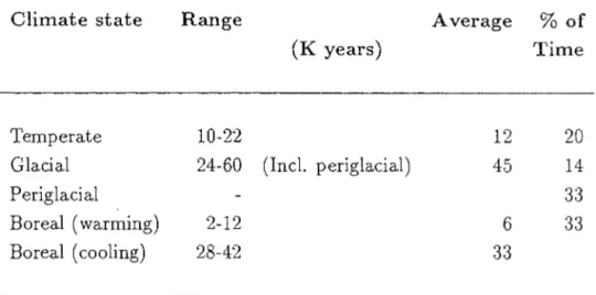
A climatic index constructed by Goodess et al (op cit), based on climatic records from deep sea cores in the Atlantic over the last 472ky, shows that the predicted length of glacial and periglacial conditions are as follows:
Climate state Range Temperate 10-22 (K years) Average % of Time 12 20
Glacial 24-60 (Incl. periglacial) 45 14
Periglacial 3:3
Boreal (warming) 2-12 6 33
Boreal (cooling) 28-42 33
Table 7 .1 Average climate state lengths calculated from the 184 climate index of Imbrie at al (1984) by Goodess et al (1989).
It could be assumed as a pessimistic case that permafrost conditions could be present in Sweden for the maximum time indicated in Table 7.1, ie. 60ka. This increase in time, above and beyond that used in the calculations of permafrost depth, for potential permafrost development is not thought to be particularly significant when balanced against the pessimistic as-sumptions made in calculating the depth of permafrost. The precise value cif the geothermal gradient has a far more marked effect on the depth of permafrost than an increase in the cooling period of 20ka, and neglecting the influence of the ice cover on the heat exchange between the rock and the atmosphere in the calculations has already maximised its predicted depth. It will take a considerable period of time of sub-zero mean annual temperatures before any noticeable continental ice sheets form, and it will be during this period when the maximum cooling of the ground is likely to take place and when the increase of permafrost thickness will be most rapid.
Goodess et al (op cit) have also constructed a possible sequence of events for the climate of the
UK
over the current glacial/interglacial cycle, from 10ka BP to 98ka AP:10ka BP - 2ka AP: 2ka AP - 35ka AP: 35ka AP - 80ka AP: 80ka AP - 86ka AP: 86ka AP - 98ka AP:
temperate, interglacial boreal - cooling
glacial / p eriglacial boreal - warming temperate , interglacial
with a similar cycle repeating, approximately ten times within the next million years.
A similar analysis of future climatic conditions has been carried for Sweden by relating the output from Imbrie and Imbrie's (1980) response model to evidence from foraminifera from the Denmark area (Lykke-Anderson, 1987) together with evidence from past climatic events. It is calculated that cooling up to 23ka AP is likely to produce continental ice sheets similar to the situation that existed at isotope stage 4 (Imbrie and Imbrie, 1980), when parts of Scandinavia were glaciated (Lundqvist, 1986). There is no reliable evidence to suggest how extensive this glaciation might have been; Lykke-Andersen (1987) states that it did not extend further south than the Goteborg area, whereas Lagerlund (1987) provides evidence for an ice lobe extending as far south as the Polish coast. This glaciation was, however, much more restricted than the one in Late Weichselian times. Therefore, according to the Imbrie and Imbrie (1980) model, parts of Sweden will start to become glaciated within the next 20ka, with a glacial culmination at 23ka. These stadial conditions are likely to be followed by an interstadial climate, and the ice sheet is expected to have melted by 30ka AP. If this interstadial is comparable with isotope stage 5a, and hence with the Tarendo Interstadial in Sweden (Lagerback,1988), it would imply that harsh climatic conditions could be expected, at least in the north of Sweden. Extensive permafrost could therefore be expected over most of Sweden. At 50ka AP the main glacial advance is expected to commence, with a maximum glaciation at 63ka AP. This glaciation can be related to isotope stage 2, and is therefore similar to the situation in the Late Weichselian. A further interglacial optimum is expected at 75ka AP with another glacial advance around 100ka AP. This implies that large parts of Sweden will be glaciated three times over the following 100ka.
It is likely that a cyclicity paralleling that described by Goodess et al (1988) will take place, with the extent of the periglacial/ glacial events being more pronounced. A northward decrease in mean annual air tem-peratures of 1°C per 150-200km is usually observed and central Sweden lies 800km north of central UK. Estimates of the average UK tempera-tures during the last glacial maximum (about 18ka BP) are at least 10°C below present levels; summer temperatures were below lOoC and winter temperatures below -16 and possibly -20°C (Goodess et aI, 1988). Extrap-olation to Sweden would suggest that the respective temperatures there were below 6°C and below -20°C.
Using the argument above as a guide to future climatic states in Sweden, it is assumed for the present discussion that periglacial conditions com-mence 15-20ka AP and continue until100ka AP. During this period either periglacial or glacial conditions are thought likely to be present in central
8
and northern Sweden for a large part of the time, but the mean annual air temperatures are likely to fluctuate from perhaps -15 to -20°C during a glacial period to perhaps only just <O°C during periglacial times, and sev-eral degrees higher at the climatic optimums during interstadials. For the development of permafrost the mean annual air temperature is required to be below -1.6°C, and within the level of uncertainty of future climate states, the most pessimistic assumption could be that this air temperature is not exceeded during the whole of the 80ka period. This may be much too pessimistic because, based on the existing distribution of permafrost in Canada (Johnston, 1981), it is observed that it is only when the mean annual air temperature is < -3 to-5°C approx that widespread discon-tinuous permafrost is present, and it is only when the mean annual air temperature is <-soC that continuous permafrost exists. It may be that a discontinuous permafrost case needs to be examined in addition to that of continuous permafrost, with repeated cycles of advance and retreat of the continuous permafrost front. In addition, the advance of continental glaciers may restrict permafrost development only to the periods of time before the glaciers are present on the site, and the most optimistic as-sumption could be that permafrost only develops for periods of less than perhaps 5 to10ka in the initial cooling, pre-glacial stages of any cooling cycle.
Estimates of permafrost thickness were first made for Canada (Judge, 1973) and relied on knowledge of ground temperature variations, both spatially and with time, the thermal conductivity of the rock and the regional variations in geothermal heat flux. In the last few years more sophisticated calculations and detailed borehole studies have been carried out as development has increased in arctic regions (Lachenbruch et aI, 1982; Osterkamp and Payne, 1981; Osterkamp et aI, 1985) We have made similar scoping calculations for the situation in Sweden at the reference repository site, and these are described in section 8.
Permafrost behaviour around a repository
Scoping calculations have been carried out for the situation of a repository situated at a depth of 500m and assumed to be at the SKI reference site. An approximate solution has been derived for calculating the temperature at depth under permafrost conditions and also for calculating the influence of heat emitting radioactive waste on the effects due to the permafrost. One of the questions addressed is the possibility of generating a "bubble" of unfrozen water around a repository within an area of deep permafrost. Were such a situation to occur it could have significant implications on
8.1
the pattern of groundwater flow around a repository, the nature and rates of near-field processes and the far-field transport of radionuclides.
After the approximations used in the thermal calculations have been jus-tified, a general solution to the problem is derived and a few examples of specific repository situations are illustrated.
Statement of the thermal problem
The thermal problem to be solved can be described as follows:
1. The initial temperature profile in the ground is known from present day measurements. It is not necessarily a steady state since the influence of the last glacial event may still be significant at depth. 2. Due to future glacial events the ground surface will be cooled,
in-ducing a time dependent surface temperature boundary condition, which can be predicted reasonably accurately.
3. Due to the cooling the water contained in the rock will freeze, thereby inducing a thermal sink term equal to the latent heat of freezing. 4. The heat transfer within the rock will be governed by conduction and
advection, and the geothermal heat flux will result in temperatures increasing with depth. Natural heat sources are also present in the rock due to the radioactive decay of U and Th and their radioactive daughters.
5. The growth of any surface ice sheet will act as an insulating layer between the atmosphere and the ground
6. The heat emitted by the waste will increase the temperature around the repository.