Scientific Press International Limited
Water Harvesting in Iraq: Status and
Opportunities
Mukhalad Abdullah1, Nadhir Al-Ansari2 and Jan Laue2
Abstract
Water harvesting in Iraq is an old application with limited extent. Western Desert, Jazeera Desert and Eastern Valleys, are the zones were the water harvesting must be employed. Several water harvesting dams in Western Desert had built since 1970s, these dams are intended to provide habitat and recharge of groundwater resources. There is limited opportunity to recharge groundwater in Jazeera area due to existence of gypsum layers. Regarding Eastern Valleys, the experience of building water harvesting dams on the valleys manifested that sediments accumulation is the main obstacle to adapt this solution. Hemrin Hills considered as one of the most intensively eroded areas in Iraq, so, soil conservation and water harvesting development is important. Many small dams were built in mountainous zone in the last two decades, some are important for agriculture expansion, but there is need to evaluate the effects on large dams feeding. North-Eastern parts of Jordan, which has similar natural conditions of Northern Desert, had present a successful example of water harvesting development.
Keywords: Water Harvesting, Small Dams, Western Desert, Jazeera Desert,
Eastern Valleys.
1 Mukhalad Abdullah, Private Engineer, Baghdad, Iraq. 2 Lulea University of Technology, Lulea 971 87, Sweden.
Article Info: Received: January 3, 2020. Revised: January 14, 2020.
1. Introduction
Iraqi lands are classified as one of the arid and semi-arid regions, except the northern parts [1]. With an area of desert estimated about half of the country territories and future challenges of water scarcity, it is vital importance to adapt the proper and economically efficient alternatives for water harvesting in Iraq.
Water harvesting in Iraq is not a new technique, it was conducted since early civilization. Even in Abbasid era, some projects were implemented in the western desert [2]. Some of the existing water harvesting locations were evolved naturally. In the recent history, development of water resources utilization in Iraq started mainly after 1921 when the establishment of Iraqi Kingdom. Later, the most important step was the establishment of Development Board in 1950s which had built some large dams, irrigation projects and barrages. No interest was paid to water harvesting until 1970s, when studies and implementation of several water harvesting dams in the western desert had started. However, the other techniques of water harvesting are not tested yet, and even the research side has no tangible outcomes in term of field data.
2. Natural Conditions
Iraq total area is 438,320km² [3], there are different land features in Iraq; Mountains, Hills, Fluvial planes, desert and water bodies. The land can be distinguished into several zones. Namely, mountainous zone in the north-eastern parts with high and extremely high mountains, where the maximum altitude is 3,550m a.s.l. [3], and then the low folded zone, which extends from the south-east to north-west below the mountainous zone. Tigris, Tigris Tributaries and Euphrates rivers are flowing through Iraq; most of the main rivers are shared with riparian countries. In the north-east of the country, Jazeera desert which is bordered from the south by Euphrates, Jazeera desert area is 31,226km2. The eastern and south eastern parts of the country are prevailed by Western desert; this is divided for administrative purposes into; Northern Desert with an area of 101,339km2 and Southern desert with an area of 76,144km2 [4]. The most important and historically populated zone is the Mesopotamian Plain, which is surrounded by deserts and low folded zone. Figure 1 shows the physiography of Iraq.
Rainfall in Iraq is occurred in the winter from December to February, except in the north and northeastern parts, where the rainy season is from November to April. Average annual rainfall is estimated at 216mm, but ranges from 1200 mm in the northeast to less than 100mm over 60% of the country in the south. Winters are cool to cold, with a day temperature of about 16°C dropping at night to 2°C with a possibility of frost. Summers are dry and hot to extremely hot, with a shade temperature of over 43°C during July and August, yet dropping at night to 26°C [3]. The rainfall within the mountainous area is 18.3% of the total country rainfall, where the annual rain varies between 500-1200mm, 9.6% of the rainfall in the low folded area, the annual rain varies between 300-500mm, 6% of the rainfall in Jazeera desert, with annual rain of 150-400mm, 23.6% is in Mesopotamia with
mean annual rain of 150mm, and 42.5% of the rainfall is in Western Desert with mean annual rain of 100mm or less [2]. The mean annual evaporation in Western Desert is 3200mm [6]. Figure 2 shows the contours of evaporation in Iraq. Hence, the need to maintain the quality and quantity of water in Western Desert has the highest priority. Many small dams were built in 1970s and 1980s [4], [7]. Also, the experience in other countries in MEAN region showed that there are more feasible opportunities to invest in water harvesting [8].
3.
Overview of Water Harvesting Existence in
Iraq
Water harvesting in Iraq can be founded into two main categories: small water harvesting dams, and natural water harvesting ponds.
3.1 Small Dams for Water Harvesting in Iraq
Small dams in Iraq are in three main regions [10]: 1. Northern Area
2. 2. Eastern Valleys 3. 3. Western Desert.
Small dams in Northern area are either built to store water for the development of irrigation projects or in the sub-catchments of the main rivers. Developing of irrigation projects in the plains of the mountains was studied carefully; a dam like Duhok dam is a good example; many other dams were planned but not completed yet [7]. Regarding the dams that had been built in the sub-catchments, especially after 2003, there is still controversy about the feasibility of building small dams in the catchments of another major dam. Local authorities, without consulting central government, continues planning and implementing such small dams.
Figure 2: Evaporation rate contours in Iraq [9].
Eastern Valleys is the area restricted between Tigris River, Iraq-Iran border; Diyala River Irrigated lands and Hawizeh Marshes. Several mutual valleys are between Iraq and Iran. The main valleys are (Nafit, Harran, Hizzam, Talha, Shourshen, Badra, Teeb, Dewerej) [11]. These valleys are distinguished with a relatively high sediment load, due to the erodibility of soil, difference in altitudes and the frequency of the intensity of rainstorms. Several dams were built after 2003, but most of them
suffering from the accumulation of sediments in the reservoirs. These dams are: 1. Qazaniyah Dam: it is located on the Harran Valley. It is a 6.5 meter-high
weir dam; lake capacity is 0.9 million cubic meters. The dam commissioned in 2007. Further, the dam suffers from the accumulation of sedimentation. 2. Mandalay Dam: it is located on the Harran Valley. It is an earth fill dam with clay core, 14m high and 1,316m long. The capacity of the lake is 3.63 million cubic meters, there is a 250-metre long spillway with discharge of 1 725m3/s. Dam reservoir is almost full with sediments. Figure 3 shows a
general view of Mandaly Dam Reservoir filled with sediments.
3. Shihabi Dam: it is located on Shihabi Valley. Dimensions are 275m long and 9m high. It includes a 160 meter long spillway. The capacity of the lake is 0.8 million cubic meters. Also, the dam is filled with sediments.
4. Dewerej Dam: the dam is located on the Dewerej Valley. The dam is a concrete weir with other retention dam made from Gabions. It is 510m long and 9.5m high. The capacity of the reservoir is 1.87 million cubic meters. It was completed in 2015.
5. Badra Dam: it is located on Badra Valley. It is a concrete weir of 3m high and 800 meters long.[7][10]
Figure 3: General view of Mandaly Dam Reservoir filled with sediments [12].
Western Desert is the most important in terms of need for water resources and providing habitat for man and animals. Many dams were built before 2003, unfortunately, the instable security caused to stop any more projects. The existing water harvesting dams are:
1. Husub Dam: the dam is located on Husub Valley. The length of the dam is 1050m and its height is 11m. The size of the reservoir is 4.2 million cubic meters. Dam was completed in 2005.
2. Horan 2 Dam: it is located Horan Valley. The dam is 650m long and 14m high and has a storage capacity of 4.9 million cubic meters.
3. Rutbah Dam: it is located in the Northern desert. It is 848 meters long earth fill dam, and the height is 19m. Reservoir capacity of 32 million cubic
meters. The dam was completed in 1981.
4. Al-Ubailah Dam: It is a 500 meter long earth fill dam; the height is 11.5m. Reservoir storage capacity of 4 million cubic meters. It was completed in 1973.
5. Al-Aghri Dam: It is a 525 meter long earth fill dam, the height is 11m. Reservoir capacity is 6 million cubic meters. The dam completed in 1974. 6. Hussainiyah Dam: It is a 512 meter long earth fill dam; height is 13.25m. The dam has a storage capacity of 6 million cubic meters. The dam completed in 1976.
7. Shibaijah Dam: It is a 720 meter long earth fill dam; height is 10.5m. The storage capacity of 8 million cubic meters. It was completed in 1977. 8. Rahaliyah Dam: It is a 440 meter long earth fill dam; height is 13m. Dam
storage capacity is 4 million cubic meters. It was completed in 1982. 9. Um Al-Tarfat Dam: It is a 990 meter long earth fill dam; height is 11.6m.
The storage capacity is 7 million cubic meters. Dam was completed in 1982. 10. Surry Dam: It is a 570 meter long earth fill dam; height is 5m. The dam has
a storage capacity of 0.3 million cubic meters. Dam was completed in 1976. 11. Abyadh Dam: It is a 448 meter long earth fill dam; height is 20m. Dam
capacity is 25 million cubic meters. It was completed in 2002 [7][10].
3.2 Natural Water Harvesting Ponds
Several natural formations of water harvesting are in the deserts of Iraq, these formations were naturally evolved, most of these were named after local nomenclatures. These formations are:
1. Khabari: these are natural depressions, where some of them are with clay bed, and could store the collected water for 1-2 months. There are 73 Khabari are in Northern Desert and 22 in Southern Desert.
2. Ghidran: small natural depressions of dimensions from 10 to 500m, and depth from 1 to 5m, these are formed as trenches inside valleys.
3. Thighab: like Ghidran but smaller, and formed inside shade.
4. Chaltat: small ponds where water collected from the surrounding hills. The total number of Ghidran, Thighab and Chaltat in Northern Desert is 77, and in Southern Desert is 57.
5. Water Springs: some water springs are in Jazeera Desert, near Tharthar Valley, but it’s not suitable for drinking, used only for agriculture. In Western Desert, there is what is so called springs line which extends for about 500km in both Northern and Southern deserts. Springs line start from Kubaisa then Rahalia, Ayn Tamr, Khan Al-Rahba, Ameid and reach to the west of Ur of about 50km. The quality of water is acceptable in the northern parts, but it’s deteriorating after in the middle and southern parts. An Irrigation projects was developed in Ayn Tamr to irrigate 14.8 thousand donums. 5.3km earth canals were linked with 4 springs. Also, 7 drains were excavated with total length of 24.26km to cover the project. Figure 4 shows
a view of a spring in Ayn Tamr.
6. Faidhat: natural wide ponds on the path of valleys or at the end of valleys. Water is spreading in Faidhat, the soil of it is loamy soil, these utilized for agriculture. The well-known Faidhat in Northern Desert are (Massad, Sahban, Sanba’a, Ga’ar, Hammir) and in Southern Desert are (Battin, Wagsa, Theib, Gulaib, Urdhumma, Hazma) [4][13].
Figure 4: A spring in Ayn Tamr [12].
4. Water Harvesting in Low Folded Zone
Hemrin Hills among the most intensively eroded areas in Iraq [1]. Also, the area faced slopes collapse due to sever erosion. Slopes lower parts are exposed to differential erosion. This caused the collapse of upper parts. On another hand, weathering play role in collapses [14]. Regardless of that, no initiatives were made to stop the erosion. Certainly, the development of micro water harvesting and soil conservation techniques will reduce sediment accumulation in Hemrin Dam or Adheim Dam, as well as retain soils and enlarge green area in the country.
5. Water Harvesting in Jazeera Desert
Jazeera desert surrounded from the south by Euphrates River, from the East by Tharthar Lake and Tharthar Valley, from the north by Mountains of Sinjar and Sheikh Ibrahim, and from the West by the Syrian-Iraqi borders.
Water quality of wells in the area almost not suitable for agriculture, it’s affected by the gypsum layers beneath. TDS varies between 3000-1000p.p.m [4]. Hence, ground water recharge is not suitable in this area. Among the possible, solutions are adopting water spreading techniques to water the top soils or reduce reservoirs bed infiltration rate to reduce the seepage.
Some studies interested in developing the Northern parts of Jazeera Desert, as well Tharthar Valley. Tharthar Lake water qualities are considered low due to evaporation and bed layers solution [15], [16]. So, the utilization of the flow in surrounding valleys before entering the lake will protect fresh water from salinity effects. The estimated water income in Tharthar Valley near Hatra during the rainy season of 2012 and 2013 was around 141 million cubic meters. Figure 5 shows the catchment area of Tharthar Valley upstream of Hatra.
Sinjar area was also studied by researchers. The average annual rainfall in Sinjar is 320mm [17]. Analysis for 20 years of the period (1990-2009) revealed that for a selected 6 basins in the north of Sinjar Mountain with total area of 614.19km2, the annual harvested water varied between 0.6 to 42.4 million cubic meters. While, for the same period and for other 4 selected basins in the eastern of Sinjar Mountain with total area of 435.14km2, the annual harvested water varied between 0.11 to 28.11 million cubic meters [18], [19]. Researches highly recommended to utilize the surrounding basins of Sinjar Mountains for complementary irrigation of wheat as it had been showed promising results [20].
6. Water Harvesting in Western Desert
As mentioned, Western Desert is administratively portioned into Northern Desert and Southern Desert. Physically, there are many distinguishing features in the vast area of about 177.5km2.
Main valleys in Northern Desert are Sawab, Walij, Hawran, Huzzaimi, Ghadaf, Tebil, Abyadh, A’ra’ar, Hammir and Al-Hur. While the main valleys in Southern Desert are Sedair, Husub, Huweimi, Awja, Igrewi, Gharabiya, Kura’, Ghanimi, Khour Ghunaim, Bsaia, Batin and Rahalt Al-Boosh [4]. Figure 6 shows some of the main valleys in Western Desert.
Figure 6: Main valleys in Western Desert[22].
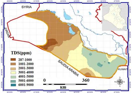
Contrary to Jazeera Desert, Western Desert is more suitable for groundwater recharge. Renewable and non-renewable resources are existing in the major formations. The main formations in Western Desert are: Dibdibba, Euphrates, Dammam, Umm Er Radhumma, Tayarat, Hartha, Rutba, Gaara [24]. Quality of water varies in different aquifers and different depths, but there are many opportunities to use the renewable resources for agriculture. Some farmers who lived near main cities are using today pivot sprinklers to cultivate some crops. Figure 8 below shows the extension of Umm Er Radhumma aquifer and TDS distribution.
Figure 8: Extensions of Umm Er Radhumma aquifer and TDS distribution [24].
7. Discussion
Water harvesting in Iraq is of a limited extent in the exploitation of the available capacity or adapting the applicable technologies. Many small dams had been built in high folded and low folded zones, especially after 2003; many questions were raised about the effect of these dams on water balance of large dams on Tigris River tributaries. The major issue in these zones is the conservation of soil; remedies may include terraces, check dams, water spreading systems, and drainage improvement. Fine-tuning of dam selections in this area is of vital importance.
Eastern Valleys is another important point of interest; the experience with the existing dams was made useful lessons. Building new water harvesting dams will be risked by sediments accumulation, even the underground dams may confront the same risk, where the fine sediments may clog the pervious layers. There is a high value of uncertainty regarding Eastern Valleys, no enough field data, no enough discharge measurements on valleys, and most of the predictions are based on geodatabase and computer analysis. This can be mirrored to Jazeera and Western Desert also. It’s easily to say that more data are required, and may be the water spreading systems and temporary dams, inflatable dam, are good alternatives. Jazeera Desert is one of the areas that lack security. This is also applying to Western Desert. The main feature of Jazeera is Tharthar Lake; many of valleys are discharging into the lake. Groundwater quality affected by gypsum layers, hence, spreading water on the top soil is possible and other possible solutions could be greenhouses roof rain water harvesting.
Western Desert water harvesting is not only important to enhance water resources, but it’s important also to improve environment, habitat, and reduces dust storms. One of the successful examples of an area with many similarities which is water harvesting experience in Jordan. Jordan receives average annual precipitation of 100mm/year; it’s classified as one of the most water poor countries. Many water harvesting applications had been adopted in Jordan. 56% of the country irrigation depending on wells, other majorly depending on the project of King Abdullah Canal. In 2013, there was 250 water harvesting projects and other 112 projects ongoing or planned. The largest capacity of water harvesting in Jordan are in the North-Eastern parts, near Iraq Northern Desert, it’s about 67% of water harvesting production in Jordan. According to data of 2013, the outcomes from water harvesting in Jordan were 110.75 million cubic meters [8]. Figure 9 shows water harvesting structures distribution in Jordan.
Figure 9: Water harvesting structures distribution in Jordan [8].
Finally, it’s worth mentioning that no specialized institutes are assigned to exploit desert and rural areas or examine water harvesting alternatives, as it was in 1970s. Although, efforts made by researchers, but, the lack of field measurements and experiments is one of the most important obstacles.
8. Conclusions
The average annual rainfall in the Middle East and North Africa does not exceed 166mm/year and for this reason, this area is considered as an arid to a semi-arid region. Iraq is located within the northern part of the Middle East, and it was considered as an exception due to the presence of the Tigris and Euphrates Rivers until the seventies [25], [43]. It is noteworthy to mention that Iraq is the lowest country in the catchment of the two rivers. After the seventies, the flow of the two main rivers started to decrease due to building of dams within the upper parts of the catchments of the two main rivers and their tributaries [25], [43] and the effect of climate change [44], [72]. For these reasons, Iraq is suffering from water shortage problems. To overcome this problem or minimize its effect, water harvesting techniques can be used. Number of research work to see the validity of such technique was conducted [73], [91]. The results obtained from the existing water harvesting schemes and mathematical models indicate that large quantities of water can be harvested. It is believed that excess water harvested can be artificially
charged to groundwater aquifers and be used later when required. This requires prudent water resources management planning and implementation.
References
[1] P. Buringh (1960). Soils and Soil Conditions in Iraq.
[2] K. A. Rahi and Z. N. Abudi (2005). Rainwater Harvesting Techniques Applied to Some Iraqi Zones. J. Eng. Dev., Vol. 9, no. 2, pp. 82–90, 2005.
[3] FAO (2009). Irrigation in the Middle East region in figures - AQUASTAT Survey 2008.
[4] Ministry of Planning (1988). Development of Desert Areas.
[5] Sissakian, V. K. and Jab’bar, A. M. F. Classification of the Alluvial Fans in Iraq. Iraqi Bull. Geol. Min., vol. 10, no. 3, pp. 43–67, 2014.
[6] Kamel, A. and Mohammed, A. (2010). Determination of water harvesting regions in Iraqi western desert using GIS system. Iraqi J. Desert Stud., Vol. 2, No. 2, pp. 33–42, 2010.
[7] Al-Simawi, H. (2008). Encyclopedia of Dams in Iraq.
[8] FAO (2016). Assessment of the water harvesting sector in Jordan. Final report. [9] Al-Ansari, N.A. (2015). Management of Water Resources in Iraq :
Perspectives and Prognoses Engineering.
[10] Abdullah, M., Al-Ansari, N. A. and J. Laue (2019). Water Resources Projects in Iraq : Medium and Small Storage Dams, no. January.
[11] Abdullah, A.A.A. (2012). Mutual Border Rivers between Iraq and Iran and their Impact on Agri-lands and Water Security. Univ. Tikrit J. Sci., vol. 20, no. 1.
[12] Ministry of Water Resources (2019). Ministry of Water Resources Official Page on Facebook. [Online]. Available: https://www.facebook.com/waterresources2/. [Accessed: 14-Jun-2019]. [13] Al-Simawi, H. (2010). Irrigation and Drainage Project in Iraq.
[14] Abood, M. R., Hussain, A. I. and Ali, J. M. (2013). Study of rock slope stability of formation outcrops in Hamrin Anticline /NE Tikrit. Iraqi J. Science, Vol. 54, No. 4, pp. 1115–1128.
[15] Al-Ta’i, M. (2015). Effect of Influent Point of Atharthar Lake on the Distribution of Water Quality, Baghdad.
[16] D. G. of Industry (1957). Tharthar Salinity, a Report Submitted to Development Board.
[17] Al-Ansari, N. A., Ezz-aldeen, M., Knutsson, S. and Zakaria, S. (2013). Water Harvesting and Reservoir Optimization in Selected Areas of South Sinjar Mountain , Iraq. J. Hydrol. Eng., December, pp. 1607–1616, doi: 10.1061/(ASCE)HE.1943-5584.0000712.
[18] Mountain, S., Zakaria, S. and Al-Ansari, N. A. (2012). Rain Water Harvesting and Supplemental Irrigation at Northern. J. Purity, Vol. 1, No. 3, pp. 121–141.
[19] Zakaria, S., Al-Ansari, N. A., Ezz-aldeen, M. and S. Knutsson (2012). Rain water harvesting at eastern sinjar mountain , Iraq. Geosci. Res., Vol. 3, No. 2, pp. 100–108.
[20] Zakaria, S., Al-Ansari, N. A. and Knutsson, S. (2013). Wheat yield scenarios for rainwater harvesting at Northern Sinjar Mountain, Iraq. Nat. Sci., Vol. 05, No. 10, pp. 1057–1068, doi: 10.4236/ns.2013.510130.
[21] Saleh, S. A., Abdulrahman, O. R. and Salih, A. M. (2017). Innovated Method to Estimate the Water Income in the Section of Tharthar Valley near the Site of Hatra Proposed Dam. Vol. 22, No. 6, pp. 88–102.
[22] Al-muqdadi, S. W. (2012). Groundwater investigation and modeling - western desert of Iraq.
[23] Sulaiman, S. O., Kamel, A. H., Sayl, K. N. and Alfadhel, M. Y. (2019). Water resources management and sustainability over the Western desert of Iraq. Environ. Earth Sci., vol. 78, no. 16, pp. 1–15, doi: 10.1007/s12665-019-8510-y.
[24] Aljawad, S., Al-Ansari, N.A., Adamo, N., Sissakian, V. K., Laue, J. and Knutsson, S. (2018). Groundwater Quality and Their Uses in Iraq. Journal of Earth Sciences and Geotechnical Enineering., Vol. 8, No. 3, pp. 123-144. [25] Al-Ansari, N.A. (2019). Climate Change in Arid and Semi-Arid Regions with
special reference to Iraq. Vaasa Climate Change Conference & Networking Forum 2019, 26-28.9.2019, Vaasa, Finland.
[26] Al-Ansari, N.A., Adamo, N., Sissakian, V.K. (2019). Hydrological Characteristics of the Tigris and Euphrates Rivers. Journal of Earth Sciences and Geotechnical Engineering, Vol. 9, No. 4, pp. 1-26.
[27] Al-Ansari, N.A., Adamo N., Sissakian, V.K (2019). Water shortages and its environmental consequences within Tigris and Euphrates Rivers. Journal of Earth Sciences and Geotechnical Engineering, Vol. 9, No. 4, pp. 27-56. [28] Al-Ansari, N.A., Jawad, S., Adamo N., Sissakian, V.K. (2019). Water Quality
and its Environmental Implications within Tigris and Euphrates Rivers. Journal of Earth Sciences and Geotechnical Engineering, Vol. 9, No. 4, 57-108. [29] Al-Ansari, N.A. (2019). Agricultural Activities and Hydropolitics of the Tigris and Euphrates Rivers. Conference on the Development of Agricultural Sector in Iraq: problems and Solutions, 29th June, 2019, London. Organized by the Iraqi Association of Iraqi Academics UK at the Polish Social and Cultural Association, London, UK.
[30] Al-Ansari, N.A. (2019). Water politics of the Tigris and Euphrates Basins, Middle East Water Forum Publications, https://www.mewf.de/ (in Arabic). [31] Al-Ansari, N.A. (2019). Hydro Geopolitics of the Tigris and Euphrates, In
Recent Researches in Earth and Environmental Sciences Part of the Springer Proceedings in Earth and Environmental Sciences book series (SPEES), pp.35– 70.
[32] Al-Ansari, N.A. (2019). Variation of Water Quality of the Tigris and Euphrates Rivers, Anbar University conference on Upper Euphrates Basin Development. 18-20 March, Haditha, Iraq.
[33] Al-Ansari, N.A. (2018). Present problems of water resources in Iraq and possible solutions. Workshop on the risks of water crisis in Iraq and its causes and possible solutions. Organized by Iraqi Ministry of Planning, 10-11 November, 2018, Baghdad, Iraq.
[34] Al-Ansari, N.A. (2018). Problems of Water Resources in Iraq, Water Scarcity in Iraq, Towards Sustainable Water Resources Management in Iraq. Workshop organized by Al Kindi Society of Engineers, Chartered Institution of Water and Environmental Management, London 31st June.
[35] Al-Ansari, N.A. (2018). Water Resources problems in Iraq, Desertification and Water Scarcity in Iraq: Effects and Solutions conference. 1st July 2018, London. Conference organized by The Association of Iraqi Academics, UK. [36] Al-Ansari, N.A. (2018). The Risks of Iraq's Water Crisis: Causes and
Treatment (in Arabic). Aljazeera Centre of Studies, Reports section. Available at: http://studies.aljazeera.net/ar/reports/2018/05/180528080122682.html [37] Al-Ansari, N.A., Adamo, N., Sissakian, V. K., Knutsson, S. and Laue, J. (2018).
Geopolitics of the Tigris and Euphrates Basins. Journal of Earth Sciences and Geotechnical Engineering, Vol. 8, No. 3, 187-222.
[38] Al-Ansari, N.A., Adamo, N., Sissakian, V.K., Knutsson, S. and Laue, J. (2018). Water Resources of the Euphrates River Catchment. Journal of Earth Sciences and Geotechnical Engineering, Vol. 8, No. 3,1-20.
[39] Al-Ansari, N.A., Adamo, N., Sissakian, V. K., Knutsson, S. and Laue, J. (2018). Water Resources of the Tigris River Catchment. Journal of Earth Sciences and Geotechnical Engineering, Vol. 8, No. 3, 21- 42.
[40] Al-Ansari, N.A. (2016). Hydropolitics of the Tigris and Euphrates Basins. Journal of Earth Sciences and Geotechnical Engineering, Vol. 8, No. 3, 187- 222.
[41] Al-Ansari, N.A., Ali, A. and Knutsson, S. (2014). Present conditions and Future Challenges of Water Resources Problems in Iraq. J. Water Resources and Protection, Vol.6, No. 12, 1066-1098.
[42] Al-Ansari, N.A., Knutsson, S. and Ali, A. (2012). Restoring the Garden of Eden, Iraq. Journal of Earth Sciences and Geotechnical Engineering, Vol. 2, No. 1, 53-88.
[43] Al-Ansari, N.A. and Knutsson, S. (2011). Toward Prudent management of Water Resources in Iraq, J. Advanced Science and Engineering Research, Vol. 1, 53-67.
[44] Al-Ansari, N.A. and Knutsson, S. (2011). Possibilities of restoring the Iraqi Marshes known as the Garden of Eden. Water and Climate Change in the MENA-Region. International Conference, Germany, 28-29 April, 2011. [45] Al-Ansari, N.A., Abdellatif, M., Ali, S. and Knutsson, S. (2014). Long Term
Effect of Climate Change on Rainfall in Northwest Iraq. Central European Journal of Engineering, Vol. 4, No. 3, 250-263.
[46] Al-Ansari, N.A., Abdellatif, M., Ezeelden, M., Ali, S. and Knutsson, S. (2014). Climate Change and Future Long Term Trends of Rainfall at North-eastern Part of Iraq J. Civil Engineering and Architecture, Vol. 8, 66, 790-805.
[47] Abbas, N., Wisimi, S. and Al-Ansari, N.A. (2016). Model-Based Assessment of Climate Change Impact on Issac River Catchment, Queensland, Engineering, V. 8, No. 7, 460-470.
[48] Abbas, N., Wasim, S.A. and Al-Ansari, N.A. (2016). Assessment of climate change impacts on water resources of Khabour in Kurdistan. Iraq, J. Environmental Hydrology, V. 24, paper 10, 1-21.
[49] Abbas, N., Wasim, S.A. and Al-Ansari, N.A. (2016). Assessment of climate change impacts on water resources of Lesser Zab, Kurdistan. Iraq, J. Engineering, V. 8, 10, 697-715.
[50] Abbas, N., Wasim, S.A. and Al-Ansari, N.A. (2016). Assessment of climate change impacts on water resources of Al-Adhaim. Iraq. J. Engineering, V. 8, 10, 716-732.
[51] Abbas, N., Wasim, S.A. and Al-Ansari, N.A. (2016). Impacts of Climate Change on Water Resources in Diyala River Basin. Iraq. J. Civil Engineering and Architecture, V.10, 10, 1059-1074.
[52] Abbas, N., Wasimi, S. and Al-Ansari, N.A. (2016). Climate Change Impacts on Water Resources of Greater Zab River. Iraq. J. Civil Engineering and Architecture, V. 10, 12, 1384-1402.
[53] Osman Y., Abdellatif, M., Al-Ansari, N.A., Knutsson, S. and Aljawad, S.B. (2017). Climate Change and Future Precipitation in Arid Environment of Middle East: Case study of Iraq. J. Environmental Hydrology, V. 25, paper 3, 1-18.
[54] Abbas N., Wasimi S.A. and Al-Ansari, N.A. (2017). Impacts of Climate Change on Water Resources of Greater Zab and Lesser Zab Basins, Iraq, Using Soil and Water Assessment Tool Model. International J. of Environmental, Chemical, Ecological, Geological and Geophysical Engineering, 11, 10, 808-814.
[55] Osman, Y, Al-Ansari, N.A. and Abdellatif, M. (2017). Climate Change Model as a Decision Support Tool for Water Resources Management: A case Study of Greater Zab River. J. Water and Climate change, V. 8, 8, 1-14. https://doi.org/10.2166/wcc.2017.083.
[56] Adamo, N., Al-Ansari, N.A., Sissakian, V., Knutsson, S. and Laue, J. (2018). Climate Change: Consequences on Iraq’s Environment. Journal of Earth Sciences and Geotechnical Engineering, Vol. 8, No. 3, 43-58.
[57] Adamo, N., Al-Ansari, N.A., Sissakian, V., Knutsson, S. and Laue, J. (2018). Climate Change: The Uncertain Future of Tigris River Tributaries’ Basins. Journal of Earth Sciences and Geotechnical Engineering, Vol. 8, No. 3, 75-93. [58] Adamo, N., Al-Ansari, N.A., Sissakian, V., Knutsson, S. and Laue, J. (2018). The Future of the Tigris and Euphrates Water Resources in view of Climate Change. Journal of Earth Sciences and Geotechnical Engineering, Vol. 8, No. 3, 59-74.
[59] Abbas, N., Wsaimi, S., Al-Ansari, N.A. and Sultana, N. (2018). Water Resources Problems of Iraq: Climate Change Adaptation and Mitigation. J. Environmental Hydrology, V. 26, Paper 6, 1-11.
[60] Adamo, N. and Al-Ansari, N.A. (2018). Climate Change and its effect on Iraq, Water Scarcity in Iraq: Reality and Future Challenges. Conference organized by the Iraqi Forum for Intellectuals and Academics, 16-17 August, Istanbul, Turkey.
[61] Adamo, N. and Al-Ansari, N. (2018). Climate Change and its Implications on Iraq: A review. International conference on Earth Science and Climate Change, 6-7 September, Zurich
[62] Adamo, N. and Al-Ansari, N.A. (2018). Climate change and its effect on the Middle East. Geological and Engineering problems of Mosul Dam, Vaasa Wild life Festival, 26-30 September, Vaasa, Finland.
[63] Adamo, N. A. and Al-Ansari, N. (2018). Climate change in Middle East and its effect on Iraq. Workshop on the risks of water crisis in Iraq and its causes and possible solutions, organized by Iraqi Ministry of Planning, 10-11 November, 2018, Baghdad, Iraq.
[64] Abbas, N., Wasimi, S., Al-Ansari, N. A. and Nasrin, S. (2018). Recent trends and long-range forecasts of water resources of northeast Iraq and climate change adaptation measures. J. Water, special issue Water Resources Management Strategy under Globe Change, V. 10 (1562), 2-19. doi:10.3390/w10111562
[65] Bassim MohBassim Mohammed Hashim, Maitham Hashim, B.M., Sultan, M.A., Maz Attyia, M.N., Al Maliki, A.A. and Al-Ansari, N.A. (2019). Al Change Detection and Impact of Climate Changes to Iraqi Southern Marshes Using Landsat 2 MSS, Landsat 8 OLI and Sentinel 2 MSI Data and GIS Applications, Applied Sciences, V. 9, 9, 1-14. doi:10.3390/app9102016 [66] Abbas, N., Wasimi, N. and Al-Ansari, N.A. (2019). Impacts of climate change
on stream flow of major four tributaries of Tigris. World Forum on Climate Change, 19-21 June, 2019. The World Forum on Climate Justice is organized by Elsevier in Glasgow at Glasgow Caledonian University.
[67] Abbas, N., Al-Ansari, N.A., Wasimi, S. and Al-Rawabdeh, A.M. (2019). Flow variation of the Major Tributaries of Tigris River due to Climate Change. Engineering, V. 11. 8, 437-442. DOI: 10.4236/eng.2019.118031.
[68] Hilo, A.N., Saeed, F.H. and Al-Ansari, N.A. (2019). Impact of Climate Change on Water Resources of Dokan Dam Watershed. Engineering, V. 11. 8, 464-474. DOI: 10.4236/eng.2019.118033
[69] Al-Madhlom, Q., Hamza, B., Al-Ansari, N.A., Laue, J., Nordell, B. and Hussein, H. (2019). Site Selection Criteria of UTES Systems in Hot Climate. The XVII European Conference on Soil Mechanics and Geotechnical Engineering, Reykjavik, Iceland, 1 - 6 September 2019.
[70] Al-Ansari, N. A. (2019). Climate Change in Arid and Semi-Arid Regions with special reference to Iraq. Vaasa Climate Change Conference & Networking Forum, 26-28.9.2019, Vaasa, Finland.
[71] Al-Madhlom, Q., Al-Ansari, N.A., Laue, J., Nordell, B. and Hussain, M.H. (2019). Climate Change and its Effect on Energy Consumption: How to overcome the problem Using Underground Thermal Energy Storage System.Vaasa Climate Change Conference & Networking Forum, 26-28.9.2019, Vaasa, Finland.
[72] Adamo, N., Al-Ansari, N.A. and Sissakian, V. (2020). Global Climate Change Impacts on Tigris-Euphrates Rivers Basins. Journal of Earth Sciences and Geotechnical Engineering, Vol.10, No. 1, 49-98.
[73] Al-Ansari, N.A., Zakaria, S., Mustafa, Y.T., Ahmad, P., Ghafour, B. and Knutsson, S. (2013). Development of Water Resources in Koya City, Iraq, 1st International Symposium on Urban Development of Koya, December 16-17, Koya University.
[74] Al-Ansari, N.A. (2013). Management of Water Resources in Iraq: Perspectives and Prognoses. J. Engineering, V.5, 8, 667-684.
[75] Zakaria, S., Al-Ansari, N.A. and Knutsson, S. (2012). Rain Water Harvesting and Supplemental Irrigation at Northern Sinjar Mountain, Iraq. Journal of Purity, Utility Reaction and Environment, Vol.1, No.3, 121-141.
[76] Zakaria, S., Al-Ansari, N., Ezz-Aldeen, M. and Knutsson, S. (2012). Rain Water Harvesting at Eastern Sinjar Mountain, Iraq. J. Geosciences Research, V. 3, No. 2, 100-108.
[77] Al-Ansari, N.A., Alroubai, A. and Knutsson, S. (2012). Sedimentation Rates in two Water Harvesting Schemes at the Jordanian Badia, J. Ecology and Environmental Sciences, V.3, No.3, 82-86.
[78] Al-Ansari, N.A., Alroubai, A. and Knutsson (2012). Bathymetry and Sediment survey for two old water harvesting schemes, Jordan. Journal of Earth Sciences and Geotechnical Engineering, Vol. 2, No. 2, 13-23.
[79] Al-Ansari, N.A., Al-Hanbaly, M. and Knutsson, S. (2013). Hydrology of the most ancient water harvesting schemes. Journal of Earth Sciences and Geotechnical Engineering, Vol. 3, No. 1, 15-25.
[80] Zakaria, S., Al-Ansari, N.A. and Knutsson, S. (2013). Rainwater Harvesting Using Recorded and Hypothetical Rainfall Data Scenarios. Journal of Earth Sciences and Geotechnical Engineering, Vol. 3, No. 2, 21-42.
[81] Zakaria, S., Al-Ansari, N.A., Mustafa, Y., Mohammed, D.A., Knutsson, S., Ahmed, P. and Ghafour, B. (2013). Rainwater Harvesting at Koysinjaq (Koya), Kurdistan Region, Iraq. Journal of Earth Sciences and Geotechnical Eng., Vol. 3, No. 4, 25-46.
[82] Zakaria, S., Al-Ansari, N.A. and Knutsson, S. (2013). Wheat Yield Scenarios for Rainwater Harvesting at Northern Sinjar Mountain. Iraq. J. Natural Science, V.5, 10,1057-1068.
[83] Zakaria, S., Al-Ansari N.A., Mustafa, Y., Alshibli, M. and Knutsson, S. (2013). Macro Rain Water Harvesting Network to Estimate Annual Runoff at Koysinjaq (Koya) district, Kurdistan region of Iraq. J. Engineering, V. 5, 12, 956-966.
[84] Zakaria, S., Mustafa, Y., Mohammed, D.A., Ali, S.S., Al-Ansari, N.A. and Knutsson, S. (2013). Estimation annual harvested runoff at Sulaymaniyah Governorate, Kurdistan region of Iraq, J. Natural Science, V.5,.12,1272-1283. [85] Al-Ansari, N.A., Ezz-Aldeen, M., Knutsson, S. and Zakaria, S. (2013). Water harvesting and reservoir optimization in selected areas of south Sinjar Mountain, Iraq. ASCE J. Hydrologic Engineering, V. 18, 12, 1607-1616. [86] Zakaria, S., Al-Ansari, N.A., Dawood, A.H. and Knutsson, S. (2014). Future
Prospects for Macro Rainwater Harvesting Technique at Northwest Iraq. Journal of Earth Sciences and Geotechnical Engineering, Vol. 4, No. 1, 1-16. [87] Al-Ansari, N.A., Abdellatif, M., Zakaria, S., Mustafa, Y. and Knutsson, S.
(2014). Future Prospects for Macro Rainwater Harvesting (RWH) technique in north east Iraq. J. Water Resource and Protection, V.6, No. 5, 403-420. [88] Al-Ansari, N.A., Knutsson, S., Zakaria, S. and Ezildeen, M. (2015). Feasibility
of using small dams in water harvesting, Northern Iraq. International Commission on Large Dams “ICOLD” conference, Hydropower 15, Stavanger, Norway, 15-16 June 2015.
[89] Al-Ansari, N.A., Abdulatif, M., Zakaria, S., Mustafa, Y. and Knutsson, S. (2015). Future Prospects for Macro Rainwater Harvesting (RWH) technique in north east Iraq. International Symposium on Energy Challenges and Mechanics, 8-10 July, Aberdeen, UK.
[90] Mohammad, M.E., Al-Ansari, N.A. and Knutsson, S. (2016). Estimating life span of rainwater harvesting reservoirs in Sinjar area, Iraq. J. Environmental Hydrology, V. 24, paper 9,1-10.
[91] Alwan, K.K., Al-Kubaisi, M.S.A. and Al-Ansari, N.A. (2019). Validity of Existing Rain Water Harvesting Dams within Part of Western Desert, Iraq, Engineering, V. 11, 12, 806-818. https://doi.org/10.4236/eng.2019.1112055
![Figure 1: Physiography of Iraq [5].](https://thumb-eu.123doks.com/thumbv2/5dokorg/4268635.94636/3.813.136.680.275.854/figure-physiography-of-iraq.webp)
![Figure 2: Evaporation rate contours in Iraq [9].](https://thumb-eu.123doks.com/thumbv2/5dokorg/4268635.94636/4.813.239.575.471.826/figure-evaporation-rate-contours-in-iraq.webp)
![Figure 3: General view of Mandaly Dam Reservoir filled with sediments [12].](https://thumb-eu.123doks.com/thumbv2/5dokorg/4268635.94636/5.813.250.565.502.738/figure-general-view-mandaly-dam-reservoir-filled-sediments.webp)
![Figure 4: A spring in Ayn Tamr [12].](https://thumb-eu.123doks.com/thumbv2/5dokorg/4268635.94636/7.813.201.613.277.563/figure-a-spring-in-ayn-tamr.webp)
![Figure 5: Catchment area of Tharthar Valley upstream Hatra [21].](https://thumb-eu.123doks.com/thumbv2/5dokorg/4268635.94636/8.813.247.569.465.863/figure-catchment-area-tharthar-valley-upstream-hatra.webp)
![Figure 6: Main valleys in Western Desert[22].](https://thumb-eu.123doks.com/thumbv2/5dokorg/4268635.94636/9.813.178.631.323.668/figure-main-valleys-in-western-desert.webp)
![Figure 9: Water harvesting structures distribution in Jordan [8].](https://thumb-eu.123doks.com/thumbv2/5dokorg/4268635.94636/12.813.211.575.108.532/figure-water-harvesting-structures-distribution-jordan.webp)
