I ... ~ 1 ' .·' 1 .·, ; _, . .
A Preliminary Classi-fication of Riparian Vegetation. · .. Types of the Medicine Bow Range and the. Sie:;--ra Madre .
. A .Report
Pr~pared
inF~lfillment:
of .
Coe;t-Share _:Agreement Number. 0206-90-01
. · . . . Between _ . . . · · . . · ·
· the Med.:Lc.:Lne Bow Nat.:Lonal Forest.
',
. . .
and
.
, .. The· Na:ttire conservancy
' . . '· ...
by
. · • Georg~ Jones .
Wyoming Natural DiversityDatabase · (The. Nature· .Conservancy)
. . .
Febr.uary · ~2'4 ~ ·1992
.. ,'
· .
l
Types of the Medicine Bow Range and the Sierra Madre
A Report Prepared in Fulfillment of
Cost-Share Agreement Number 0206-90-01
Between
the Medicine Bow National Forest and
The Nature Conservancy
by
George Jones
Wyoming Natural Diversity Database (The Nature Conservancy)
I_ j L i -_j I 1 'I --CONTENTS LIST OF TABLES
.
. . .
..
.
LIST OF FIGURES •. . .
.
.
.
. .
ACKNOWLEDGEMENTS. . .
.
. . .
.
. .
.
.
INTRODUCTION METHODS • • • . • • • . DATA COLLECTION • • • • . • DATA ANALYSIS • • • • •. . .
.
.
.
. . .
.
.
.
.
.
.
.
1 3 4 5 6 6 6 8 THE CLASSIFICATION • • • • • • • • • • 9DESCRIPTIONS OF VEGETATION TYPES • • • . • • • • • • • 9
CONIFER PHYSIOGNOMIC CLASS • • • • • • • • • • • 9
Picea engelmannii Series • . • • • • • • • • • • • 9
Picea engelmannii/Galium triflorum Community • • • • 10
Picea pungens Series • • • • • • • • • 12
DECIDUOUS TREE PHYSIOGNOMIC CLASS • • • • • • • • • • • • 14
Populus angustifolia Series • • • • • • • • • • • • • • 14
Populus angustifolia/Poa pratensis Community • • • • 14
TALL SHRUB PHYSIOGNOMIC CLASS . • • • • • • • • • • • • • 18
Salix geyeriana Series • • • • . • • • . • 18
Salix geyeriana/Carex rostrata Community • • • • · 18
Salix geyeriana/Poa pratensis Community • . • • • • • • 20
Other Salix geyeriana starid • • • • • • • • • 23
Salix boothii Series • • . • . • • • . • • • • 24
Salix boothii/Poa pratensis Community • • • • • • 24
Other Salix boothii stand • • • • • • • • • • • • • • 26
Alnus incana Series • . . . . • • • • • • • • • • • • • 26
Alnus incana/Mesic Graminoid Community • • • • • • • 27
Other Alnus incana stand • . • • • • • • 29
MEDIUM SHRUB PHYSIOGNOMIC CLASS • • • • • • • • • • • 29
Salix wolfii Series . . . . • . • • • . • • • • • • • • 29
Salix wolfii/Deschampsia caespitosa Community 30
Artemisia cana var. viscidula series • • • • • • • • • 31
Artemisia cana viscidula/Poa pratensis Community 31
Populus angustifolia seedling & sapling series 33
Populus angustifolia/Recent Alluvial Bar Community 33
HERBACEOUS PHYSIOGNOMIC CLASS . • • . • • • • • • • • . • 34
Carex rostrata Series • • . . • • • • • • • . • 34
Carex rostrata Community . • • • • • • • • • 35
·Carex aquatilis Series • • • • • • • • • • • • • 37
Carex aquatilis Community . • • • • • • • • • • • • • 37
Carex microptera Series . • • • • • • • • • • • • • • • 39
Car ex microptera Community . • • • • • • . • • • • • • 3 9
Juncus balticus • • • • . . • • • • • • • • • • • • 40
Juncus balticus Community • • • • • • • • • • • • 40
DISCUSSION 42 USE OF THE CLASSIFICATION •
.
. .
44REFERENCES 71
Appendix I. Tables of canopy cover in vegetation plots. 73 Appendix II. Diagrams of tree size-class structure.
.
. .
• 120 Appendix III. Maps showing locations of plots • . . • . 134 Appendix IV. Scientific and common names of plant species • • 135 Appendixv.
Key to riparian vegetation types. .
. .
. .
• 141J
I
·,'
LIST OF TABLES
Table 1. Locations and sizes of plots in stands of the Picea
engelmannii/Galium triflorum community.
. . .
.
.
. .
.
Table 2. Locations and sizes of plots in stands of the Picea
12ungens series.
.
. .
.
. . .
. . .
. .
. . .
Table 3. Locations and sizes of plots in stands of the POJ2UlUS
angustifolia/Poa 12ratensis community.
. . . .
.
.
.
. .
Table 4. Locations and sizes of plots in stands of the PoJ2ulus
angustifolia/Recent Alluvial Bar Community.
.
.
. .
Table 5. Locations and sizes of plots in Salix geyeriana
stands.
. . .
.
.
. .
.
. .
. . .
.
.
- '
Table 6. Locations and sizes of plots in Salix boothii
stands.
. . .
. . .
.
.
.
.
Table 7. Locations and sizes of plots in Alnus in can a
Table 8. Locations and sizes of plots in the stand of
Salix wolfii/Descham}2sia caes12itosa community.
Table 9. Locations and sizes of plots in stands of the
Artemisia cana/Poa 12ratensis community • . . . . •
.
.
.
. . .
stands.
the
. . .
Table 10. Locations and sizes of plots in stands of the Carex
3 49 50 51 52 53 54 55 56 57 · _, rostrata community. . • • • • . • • • .• • • • • • • 58 1 I
l '.
..: ___ ) i i I , I . ' -:Table 11. Location and size of
car ex aguatilis community.
.
Table 12. Location and size of
carex micro12tera community.
.
Table 13. Location and size of
Juncus balticus community.
.
Table 14. Locations and sizes
stands.
. . .
.
. . .
the plot in the stand of the
. . .
. . .
5.9the plot in the stand of the
. . . .
. .
.
.
.
.
.
60the plot in the stand of the
. . . .
. . .
.
.
.
.
61of plots in unclassified
LIST OF FIGURES
Figure 1. General locations of streams with sampling sites. 63
Figure 2. Riparian vegetation types. • 64
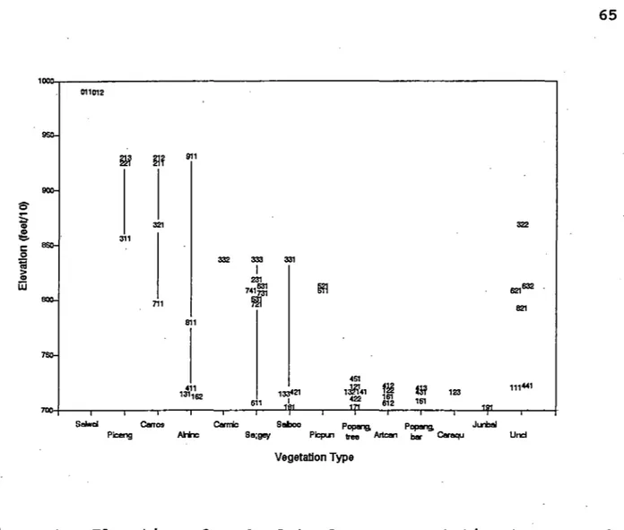
Figure 3. Elevation of each plot of every vegetation type. • 65
Figure 4. Relationship of each plot of every vegetation type
to the width of the valley floor in the region of the stand. 66
Figure 5. Relationship of each plot of every vegetation type
to the gradient of the valley in the region of the stand. • 67
Figure 6. Relationship of each plot of every vegetation type
to the sinuousity of the stream in the region of the stand. 68
Figure 7. nearest
Distance of each plot every vegetation type from the
stream channel. . . • • • . • • . . . . • 69
Figure 8. Height of each plot of every vegetation type above
r 1 I ,_ i i I ' L_: ;-I \ \ I ,
•
,--, I 5 ACKNOWLEDGEMENTSClay Speas and Nick Schmal of the Medicine Bow National Forest Supervisor's office supplied documents and maps, helped
select study sites, and assisted in producing the report. Ron
Hartman and Ernie Nelson, curator and manager, respectively, of the Rocky Mountain Herbarium at the University of Wyoming
provided space for storage and identification of plant specimens. Pat Bourgeron of The Nature Conservancy's Western Heritage Task
Force made useful suggestions on data analysis. Will Moir of the
Rocky Mountain Forest and Range Experiment Station (USFS) also gave suggestions on data management, and he and Gwen Kittell of The Nature Conservancy's. Colorado Field Office supplied
references. Wendy Haas of the Hayden Ranger District and Judy
von Ahlefeldt of the Douglas Ranger District made useful comments
..
I ! I :. ,-' II
i INTRODUCTIONIn June of 1990, the staff of the Medicin~ Bow National
Forest (U.S. Department of Agriculture Forest Service) and The Nature Conservancy entered into a challenge cost-share agreement to study riparian vegetation on selected streams in the Medicine
Bow National Forest of southeastern Wyoming. The goals of the
agreement were to (1) produce a preliminary classification of riparian vegetation types, including a description of the composition and structure of the vegetation, the physical
environment of each vegetation type, and the historical use of each stand studied; (2) interpret, as far as the data allowed, the relationship between vegetation and physical environment; and
(3) interpret, as far as the data allowed, vegetation dynamics.
Potential sampling sites were located in late June and early July, 1990 along the following five streams in the Sierra Madre
(the Hayden Ranger District) : Battle Creek, Big Sandstone Creek,
North Soldier Creek, Beaver Dam Park, and Big Creek (Figure 1). All sites on these streams were below 9500 feet elevation.
Potential sampling sites also were located along two streams in the Medicine Bow Range (Figure 1), those being the Medicine Bow River (in the Brush Creek Ranger District) and Rock Creek (in the
Laramie Ranger District). The sampling sites in the Medicine Bow
Range were at elevations between 9000 and 10,000 feet. These
sites were visited again during July, August, and September 1990, and information on species composition and vegetation structure and on physical environment was collected from 50 plots (one or
more plots representing a stand of vegetation). Plant specimens
were also collected from each plot.
The plot data were analyzed to identify groups of stands with similar vegetation -- that is, to identify vegetation types. These groups were then compared to published descriptions of riparian plant communities from Wyoming, Montana, Utah, and
Colorado. These published descriptions contain information on
vegetation dynamics and on management of riparian vegetation
types. Comparing the vegetation types identified from the plot
data with those described in the literature allows one to take advantage of this information on ecology and management of riparian vegetation.
METHODS
DATA COLLECTION
Data on canopy cover were collected from stands along five streams in the Sierra Madre and the two streams in the Medicine
Bow Range. Biologists from the Medicine Bow National Forest
staff and the Wyoming Natural Diversity Database walked the length of each stream in June and early July 1990, to identify
i ' ' \ : I : 'i
i
I L~•
stands of vegetation for sampling. WYNDD biologists returned to
the streams in July, August, and September 1990 to collect data.
7
A sample plot was marked out for data collection in each
stand. The plot was large enough to represent the vegetation and
environment of the stand and small enou~h to avoid edges of the
stand. Plots ranged in size from 100 m to 400 m2• The canopy
cover of each vascular plant species in five categories
(overstory tree; tall shrub and sapling over 1.5 meters tall; medium-height shrub and seedling 25 em to 1.5 meters tall; low shrub <25 em tall; and herbaceous) in the plot was estimated and scored into one of 10 cover classes, using a modification of the
Daubenmire canopy cover-class method (Daubenmire, 1959). Ground
cover in the plot was estimated to the nearest percent for 6 categories: bare soil (particles with longest dimension < 1/16 inch), gravel (particles with longest dimension 1/16 inch to 3 inches), rock (particles with longest dimension> 3 inches), litter (dead plant material< 1/4 inch thick, lying on ground),
wood (dead plant material~ 1/4 thick, lying on ground), and moss
(bryophytes and lichens). The vascular plant species present in
the stand but outside the plot,were listed, and specimens were collected for later identification at the Rocky Mountain
Herbarium, University of Wyoming, Laramie, WY. Specimens were
deposited in the Rocky Mountain Herbarium. The number of trees
in the plot was recorded by species, and the diameter of each tree was measured at approximately 1.4 meters above the ground.
Selected physical environmental factors were characterized for the stand by estimating the distance from the plot to the nearest stream channel, and the height of the plot above the
stream channel. (The channel was defined as that part of the
stream below the lowest perennial terrestrial vegetation.) Signs
of disturbance (flooding, roads, tree cutting, grazing, beaver dams) in the stand were noted, and the location of the stand was marked on a 1:24,000 scale topographic map.
For each stand, the width of the valley bottom in the area of the stand was estimated in the office from the 1:24,000 scale
topographic map with the following procedure: the first
topographic line intersecting the stream upstream from the stand and the first topographic line intersecting the stream downstream from the stand were noted, and the midpoint of the distance along the stream between those two topographic lines was marked on the
map. At that midpoint, the distance across the valley between
the lowest topographic line on each side of the stream was measured, and this-distance between topographic lines was
considered ~n estimate of the width of the valley bottom. This
procedure gives an approximate measure of valley bottom width, and allows comparison of the valley width from stand to stand .
Sinuousity of the stream [(stream length/valley length) x 100] near each stand was also calculated in the office from a
I ,' I i j l i i ! j : I i I i I I
200% photocopy enlargement of the 1:24,000 scale topographic map. A stretch of the stream valley including the stand, and uniform upstream and downstream from the stand for gradient and stream
sinuousity, was marked on the enlargement of the map. The length
of the valley stretch and the length of the stream channel in that valley stretch were measured with a plan measure (a map wheel), and the sinuousity calculated from those lengths. Gradient of the valley floor [(change in elevation/length of valley stretch) x 100] was also calculated for that stretch of
the stream valley. The stretches of stream valley used for
stream sinuousity and valley gradient measurements were 1/4 mile to approximately 1 mile long, and stretches commonly contained
more than one stand. Consequently, different stands have the
same values for stream sinuousity and valley gradient.
DATA ANALYSIS
Data were collected from 50 sampling plots in 44 stands, and
about 275 vascular plant species were identified. Twenty-five of
the plant species that occurred in small amounts in only one or two stands were eliminated from the data analysis; tables in this report include the remaining 250 species.
The canopy cover data were analyzed initially with two-way indicator species analysis (TWINSPAN) in the PC-ORD package
(McCune, 1991) to identify groups of plots (and, therefore, groups of stands) similar in the amount of each plant species
present. Cover values were relativized before analysis by
dividing the cover value for each species in a stand by the total
cover for all species in the stand. The data set was reduced
after cover values were relativized by removal of three groups of
species: (1) species that occurred in less than 4 stands, (2)
species that contributed < 1 % relative cover in any stand, and
(3) seven widespread and common species (Phleum pratense, meadow timothy; Poa pratensis, Kentucky bluegrass; Cirsium arvense,
Canada thistle; Taraxacum officinale, common dandelion; Trifolium pratense, red clover; Carex spp., unidentified sedge species; and
Achillea millefolium, western yarrow) . Removal of these species
left the species that contributed substantial amounts of cover to limited numbers of plots.
The reduced data set was also analyzed with cluster analysis
in the PC-ORD package. Cluster analysis is a classification
program that produces groups of similar plots using a different mathematical approach than TWINSPAN, but the two analysis
programs produced similar groups of species. Finally, the data
were analyzed with the Bray-Curtis ordination program in PC-ORD, to see how stands that the classification programs could not
place in any group related to the groups of stands. (Ordination
is a method of analysis useful for identifying gradients in
similarity of vegetation between stands. It therefore differs
i '
stands based on similarity.) Some of the stands that the
classification programs could not readily place into groups were then assigned to groups subjectively based on the results of the ordination.
The groups of species identified by the classification and ordination analyses were compared to published descriptions of riparian plant communities from the northern and central Rocky Mountains and the northern Great Plains.
THE CLASSIFICATION
The classification is a hierarchy of vegetation types with these three levels (Figure 2):
9
Physiognomic classes: vegetation types identified by the growth form of the tallest layer -- conifer class, deciduous tree class, tall shrub class, etc.
Series: vegetation types within a class identified by
the dominant species or a characteristic species in the tallest layer -- narrowleaf cottonwood series, Booth willow series, beaked sedge series, etc.
Community: vegetation types within a ~eries
identified by the dominant or characteristic overstory and understory species -- narrowleaf cottonwood/Kentucky bluegrass community, Booth willowjbeaked sedge community, beaked sedge community, etc.
Physiognomic classes are the broadest vegetation units, and each class generally contains at least two series (Figure 2). Most series, in turn, contain communities, which are the most detailed vegetation units described in this classication.
DESCRIPTIONS OF VEGETATION TYPES
CONIFER PHYSIOGNOMIC CLASS
Picea engelmannii Series
This series includes stands with tree canopies in which
Picea engelmannii/Galium triflorum Community
occurrence
Three stands of vegetation with Picea engelmannii (Engelmann spruce) overstory trees were sampled, with one 10 m x 10 m plot
per stand. Two of the stands were on North Soldier Creek, and
one was at Beaver Dam Park (Table 1). All three stands were above 8500 feet elevation (Figure 3) along straight streams
(Figure 6). This community occurs in wide valleys and narrow
valleys (Figure 4), and valley gradient can vary from nearly flat
to almost 8% (Figure 5). The plots representing the three
stands were all immediately next to the stream channel (Figure 7), and were within about half a meter above the channel (Figure
8) •
Vegetation
The composition of the tree overstory varied between plots, from mainly Engelmann spruce saplings and poles with a few small spruce trees (Figure II-1) ; to a mix of small Engelmann spruce, subalpine fir, and lodgepole pines (Figure II-2); to a few
Engelmann spruce trees with numerous subalpine fir in the
subcanopy (Figure II-3). In all stands, Engelmann spruce
dominated or codominated the canopy by cover (Table I-1) . Tall
and medium-height shrubs wer~ nearly lacking (Table I-1).
The understories in. the three plots were mixtures of
Vaccinium scoparium (grouse whortleberry) with small amounts of
various graminoids and forbs. Senecio triangularis (arrowleaf
groundsel), Caltha leptosepala (elkslip marshmarigold), Carex rostrata (beaked sedge), Glyceria striata (fowl mannagrass), Eguisetum laevigatum (smooth horsetail), Galium trifidum (small bedstraw), Mitella pentandra (fivestamen mitrewort), and
Saxifraga odontoloma (brook saxifrage) indicate wet sites. The dominance by Vaccinium suggests a drier site but, as Youngblood et al. (1985) note in their discussion of western Wyoming
riparian communities, the Vaccinium in riparian zones usually is restricted to hummocks.
Relationship to.other studies
Understories in the three Sierra Madre Engelmann spruce stands are similar to the understory described by Youngblood et al. (1985) for the Picea/Galium triflorum community type of
western Wyoming. Youngblood et al. did not assign a species
epithet for spruce in naming that community type, because they
considered ~. engelmannii and ~. punqens to be similar
ecologically in western Wyoming. In contrast, Picea engelmannii
and ~. pungens occurred in distinctly different stands in the
present study. Galium triflorum apparently is lacking from these
three Sierra Madre stands and Q. trifidum is present, but the
I -; I ! ' ' ' '
'
-I ' ' ' I ' I ! : i I 11to the western Wyoming Picea/Galium triflorum community. ·Consequently, these three stands are assigned to the Picea
engelmannii/Galium triflorum community. Steele et al. (1983)
describe a Picea· engelmannii/Galium triflorum habitat type from western Wyoming, with vegetation similar to these three Sierra
Madre stands. Johnston (1987) lists a Picea engelmannii-Picea
pungens/Galium triflorum plant association (based in part on
steele et al., 1983) from the USFS Region 2. The Picea
engelmannii-Abies lasiocarpa/Senecio triangularis habitat type described from the Arapaho and Roosevelt National- Forests of Colorado (Wasser and Hess, 1982) supports vegetation somewhat similar to the Sierra Madre riparian Picea engelmannii stands, but that Colorado habitat type occurs on very high elevation, upland sites, not riparian sites. The habitat type publications for the Medicine Bow National Forest (Alexander et al., 1986) and the nearby Routt National Forest of Colorado (Hoffman and
Alexander, 1980) do not describe riparian habitat types or vegetation types similar to the Picea enqelmannii/Galium triflorum community.
successionjManaqement
Youngblood et al. (1985) suggest that vegetation and soils in stands of the Picea engelmannii/Galium triflorum community are relatively stable, and_that this community is the climax
vegetation for the Picea engelmannii/Galium triflorum habitat
type. According to .their study, this vegetation in western
Wyoming develops rapidly on "protected sites", while sites on exposed benches and along steep streams may support intermediate vegetation types (specifically, the Cornus stolonifera/Galium triflorum or Picea/Cornus stolonifera community types) •
According to steele et al. (1983), limited data from the Picea engelmannii/Galium triflorum habitat type in western
Wyoming suggest that timber productivity ranges from moderate to very high, but the locations of stands along streams and the high
water tables may restrict timber harvest. These site factors may
make protection of water and soil resources the prime goals in management.
Other notes
Exotic plants accounted for little cover in the three stands of Picea engelmannii/Galium triflorum vegetation·sampled in this
study (Table I-1). Taraxacum officinale was present in all three
stands, but only one of the stands contained enough Poa pratensis or Phleum pratense to be sampled in the plots.
This vegetation type probably is more common than the sample size indicates. Many of the high-elevation streams in the Sierra Madre and Medicine Bow Range have Picea engelmannii-dominated riparian vegetation, and much of that vegetation may be the Picea
i
I I
' '
I_'
•••
samples results from the emphasis in this study on relatively low-elevation streams.
Picea pungens Series
This series includes stands with tree canopies in which blue
spruce is the major tree. No communities were identified in this
series.
Occurrence
Data were collected from two 10 m x 10 m plots in Picea pungens (blue spruce) woodland along the North Fork of Big Creek,
at the west end of Cunningham Park (Table 2). (These plots were
close enough together that they mj,ght best be considered as being
in the same stand.) The plots were at an elevation of 8080 feet
-- the middle of the range of elevations of all plots sampled (Figure 3) -- in a narrow valley (Figure 4) with a fairly gentle
gradient (Figure 5). The section of the North Fork of Big Creek
along the plots is nearly straight (Figure 6). Both plots were
within several meters of the stream channel (Figure 7), and were half a meter above the channel (Figure 8).
vegetation '
Picea pungens and Pinus contorta (lodgepole pine) formed the
tree overstory in both plots (Table I-1). Both plots were in
parts of the stand with fairly low tree density. Plot 511
included slightly more small lodgepole pines than blue spruce (Figure II-4), while· plot 521 included only one large blue spruce and several small pines and subalpine fir (Abies lasiocarpa)
(Figure II-5). The presence of the lodgepole pines in the overstory probably is due to the location of the stand in a narrow valley, where the riparian zone and the upland are close together.
Both blue spruce plots had considerable tall Shrub cover, with Alnus incana and willow forming the tall shrub layer in one plot and a mix of willows forming the tall shrub layer in the
other plot (Table I-1). Several species formed a sparse
medium-height shrub layer in each plot.
The herbaceous understory was fairly sparse in each plot (Table I-1). Unidentified sedges/ Geranium richardsonii,
Maianthemum stellatum, Osmorhiza §RR., and Taraxacum officinale
contributed more than 1% cover in each plot. Eguisetum
laevigatum, Frasera speciosa, and Orthilia secunda were present
in substantial amounts in one plot. Numerous other graminoids
and forbs were present in one or both plots in small amounts .
c;
~ (..;t.. (> iY) ' ~ () (D [) \) LA~ )-1I I ' ' ' . ___ __.. ' -' ! : ' I L ___ , 13
Relationship to other studies
Johnston (1987) lists a Picea pungens/Alnus incana plant association from western Wyoming, the Routt National Forest of north-central Colorado, and other parts of Colorado and New
Mexico. He does not describe the vegetation from this plant
association, but it resembles the Sierra Madre stand closely in the list of species present and the riparian site it occupies. Wasser and Hess (1982) and Hess and Alexander (1986) describe riparian vegetation from the Roosevelt National Forest in the Colorado Front Range, which they use to identify the Picea
pungens/Arnica cordifolia habitat type. The Roosevelt Forest
vegetation resembles the stand sampled in the present study, in having Picea pungens well-represented in the tree layer,
Juniperus communis and Rosa woodsii in the shrub stratum, and Osmorhiza depauperata and Smilacina stellata (=Maianthemum
stellatum) in the understory. The stands they studied differed
markedly from the Sierra Madre stand, though, in that their stands apparently lacked Alnus incana in the shrub layer and had
Arnica cordifolia as a strong understory dominant. Wasser and
Hess (1982) also describe riparian vegetation with a tree layer dominated by blue spruce from the Picea pungens/Amelanchier alnifolia-Cornus stolonifera/Carex geyeri habitat type on the
White River National Forest of west-central Colorado. The Sierra
Madre stand, though, lacks Amelanchier alnifolia and Cornus
sericea
(=g.
stolonifera) in the the shrub layer and apparentlyalso differs substantially in understorY composition from the
Colorado vegetation. Hoffman and Alexander (1983) describe a
Picea pungens/Poa spp. habitat type supporting blue spruce woodlands in the White River National Forest of west-central Colorado, but that vegetation- (and the habitat type) are clearly
on uplands, not in riparian zones. Steele et al. (1983) note
that Picea pungens woodlands grow along rivers and large streams in northwestern Wyoming, but do not describe vegetation types or habitat types from that area.
The single stand of blue spruce sampled in the present study suggests that riparian vegetation dominated by Picea pungens
occurs along some streams in the Medicine Bow National Forest, but the information from that stand is insufficient to identify a new Picea pungens community type or to associate the stand with
blue spruce vegetation types identified in other studies. Data
from other stands may show that the Picea pungens/Alnus incana plant association of Johnston (1987) occurs in the Forest.
succession/Management
Good conclusions on appropriate management of the Picea
pungens series must await more information on the composition and
environment of this vegetation type. Information on management
of vegetation on the Picea pungens/Arnica cordifolia habitat in the Roosevelt National Forest (Hess and Alexander, 1986) may be
useful, though. Hess and Alexander (1986) suggest that the
'- -: : i J ' '
: I
' I I I L-' ! I ·-' ' ' I ' I I : ' : ' I I ' ' ' I I , I : I--·
providing food and cover for wildlife. The habitat type may be
suitable for light timber harvest, but Hess and Alexander point out that the danger of soil compaction and the possibility of rising water tables following removal of trees precludes
extensive logging. Livestock use must also be limited, to avoid
soil disturbance.
Other notes
The plot data suggest that exotic plants were minor components of the vegetation in the Picea pungens stand.
DECIDUOUS TREE PHYSIOGNOMIC CLASS
Populus angustifolia Series
This series includes stands with tree canopies in which
narrowleaf cottonwood contributes as much cover as, or more cover than, other trees.
Populus angustifolia/Poa pratensis Community
Occurrence
Data were collected in six stands of Populus angustifolia
(narrow-leaf cottonwood) trees, with one plot measuring 200 m2 or
400m2 in each stand (Table 3). All six stands were at
relatively low el·evation (Figure 3) in the moderately-wide, low-gradient valleys of Battle Creek and Big Sandstone Creek (Figures
4 and 5). Battle Creek in the vicinity of the Populus
angustifolia stands is relatively straight, while Big Sandstone
Creek is quite sinuous (Figure 6). The variation in distance
from plot to stream channel (Figure 7) indicates that the
cottonwood stands grow over a range of distances from the stream, and they grow on surfaces up to nearly 1.5 meters above the
channel (Figure 8).
Vegetation
Populus angustifolia was essentially the only tree present in all but one plot (Table I-2), indicating the strong dominance
of the tree stratum by cottonwood. The size-class structure of
the cottonwood population in the stands studied typically was a preponderance of small or medium-sized trees with a cohort of
seedlings (Figures III-6, III-8, III-9, and III-10). One of the
Big Sandstone Creek stands had a tree stratum of about equal numbers of small, medium-sized, and large trees (Figure II-11), and one of the Battle Creek stands had a tree stratum of medium-sized cottonwoods with Picea pungens poles and small trees
(Figure II-6). The concentration of cottonwood trees in one or
two size classes results from the mode of establishment of the
I
-i
i
iI :
bars and islands, and the closing of the tree canopy prevents further establishment of cottonwoods (Hansen, Boggs, et al., 1991).
15
A variety of tall and medium-height shrubs occurred in the cottonwood stands (Table I-2), but shrub cover was sparse in four
of six stands. In one of the stands with substantial shrub
cover, represented by plot 132, Salix boothii formed an open tall shrub layer and the Populus angustifolia overstory was less dense
than in the other stands. In the other stand with substantial
shrub cover, represented by plot 121, Juniperus communis
contributed substantial cover beneath the mixed cottonwood/blue
spruce overstory. Alnus incana and Artemisia cana grew in half
the stands.
Total graminoid cover in- the plots (Table I-2) indicates that five of the six stands had substantial graminoid cover, with the exception being the stand with the mixed narrowleaf
cottonwood-blue spruce overstory (plot 121). Total forb cover
was at least 10% in all the plots. Every stand contained a large
number of graminoid and forb species, but usually in small
amounts. Only seven species -- Agropyron subsecundum (= A.
trachcaulum in many taxonomic ·treatments), Bromus anomalus, Carex spp., Juncus balticus, Poa pratensis, Taraxacum officinale, and Vicia americana -- occurred in at least half the stands and
contributed substantial cover in at least one stand. Five more
species -- Elymus x macounii, Achillea millefolium, Cirsium arvense, Maianthemum stellatum, and Potentilla gracilis
--occurred in at least three stands, but in small amounts. Two
species, both exotics, stood out by contributing substantial
cover in the most stands: Poa pratensis (Kentucky bluegrass)
dominated or codominated the understory in five stands, and Taraxacum officinale (common dandelion) was a major species in three stands.
Relationship to other studies
A Populus angustifolia/Poa pratensis community has been described from western Wyoming and eastern Idaho (Youngblood et al., 1985), Utah (Padgett et al., 1989), and Montana (Hansen,
Boggs, et al., 1991). Stand of this community differ from one
another somewhat in species composition, but the community is characterized by dominance of the tree stratum by Populus
angustifolia, a sparse shrub stratum, and a diverse understory that includes Poa pratensis, Agropyron trachycaulum, Maianthemum
stellatum, Osmorhiza spp., and Taraxacum officinale. The plot
data from the Sierra Madre stands suggest that these stands can
be considered occurrences of this community. The stand
represented by plot 121 may be transitional to a Picea pungens type.
Wasser and Hess (1982) and Hess and Alexander (1986)
I I
•
~-~1 I : ' i ' ' L _ •I
I I I ' !the eastern slopes of the Front Range in Colorado. The stands
described by Hess and Alexander (1986) from that habitat type contain more shrub cover and less cover by Kentucky bluegrass and common dandelion than is typical for the Populus angustifolia/Poa pratensis community, and these stands resemble the Populus
anqustifolia/Cornus sericea (=Cornus stolonifera) community of Youngblood et al. (1983), Padgett et al. (1989), and Hansen, Boggs, et al. (1991).
succession/Management
Populus angustifolia becomes established on bare substrates after flood, but not on well-vegetated substrates or under tree canopies; hence Populus angustifolia/Poa pratensis stands are
seral (Hansen et al., 1988). (The two plots in stands of
cottonwood seedlings, described below in the section on the Populus anqustifolia Recent Alluvial Bar vegetation type, illustrate the environment necessary for cottonwood
establishement.) The future of the vegetation in the Populus
angustifolia/Poa pratensis stands depends on whether the sites on
which they grow remain stable or are disturbed by floods. If the
sites are not flooded, the cottonwoods will eventually disappear and most of the sites will be occupied by herbaceous vegetation
(probably dominated by Poa pratensis) or, perhaps, by stands of
Artemisia cana (silver sagebrush). If construction of a beaver
dam or diversion of water into an overflow channel brings the water table beneath a site closer to the surface, the site may come to be occuppied by vegetation dominated by Carex rostrata
(beaked sedge), Carex aquatilis (water sedge), or other wet-site
gramninoids. One stand, represented by plot 121, apparently is
an exception; the presence of Picea pungens in the overstory indicates that this cottonwood stand will become a blue spruce stand upon the disappearance of the cottonwoods.
Investigations in Montana (Hansen, Boggs, et al., 1991) indicate that stands of the Populus angustifolia/Poa pratensis community are created by grazing, through the removal of a layer. of tall shrubs (primarily Salix exigua) and medium-height shrubs
(primarily Cornus sericea, Rosa spp., and Syrnphoricarpos spp.) from the Populus angustifolia/Cornus stolonifera (=Comus
sericea) community. This latter community is similar to the
vegetation described by Hess and Alexander (1986) from the Populus angustifolia/Salix exigua habitat type in the Colorado
Front Range, and to the
E·
angustifolia/~. exigua-Betulafontinalis (= ~. occidentalis) plant association of Johnston
(1987) . The Sierra Madre stands contain small amounts of
riparian shrubs (Alnus incana, Amelanchier alnifolia, Salix
boothii, Salix exigua, Ribes inerme, Rosa woodsii, Rubus idaeus), but the plot data do not indicate the presence of the diagnostic shrub, Cornus sericea, in the stands.
If the interpretation of the Montana Populus
•
i l __ I ~. . ' I . ! I I_· 17stands, then the Sierra Madre stands may be thought of as a grazing-induced community on the Populus angustifolia/Salix
exigua habitat type. It's unclear, though, that grazing has
removed a shrub layer from the Sierra Madre cottonwood stands to produce stands of the Populus angustifolia/Poa pratensis
community. At· least half of the Sierra Madre stands contain
Artemisia cana or Chrysothamnus spp., which may indicate that they are on sites too dry to support more than scattered
individuals of dogwood, rose, and willow. Even if these stands
originally had well-developed strata of riparian shrubs, a
decline in the water table or a rise in the soil surface (due to deposition of sediment) could have made the site unsuitable for
the riparian shrubs. Cottonwood stands should be evaluated
individually for evidence that grazing has indeed removed a formerly-widespread shrub layer, and cottonwood stands with different management histories should be investigated, before conclusions are drawn about the role of grazing in producing the
Populus angustifolia/Poa pratensis vegetation. Moreover, a
change in grazing management probably will not restore the shrub layers in existing cottonwood stands unless the stands still contain suppressed shrubs, because a Poa pratensis sod inhibits establishment of new shrubs (Hansen, Boggs, et al., 1991).
For discussions .of resource values and management practices in this community, see USDA Soil Conservation Service (1988; specifically, see range site description for the lowland range
site, 10-1411 precipitation zone high plains southeast), and
Hansen, Boggs, et al. (1991).
Other notes
Exotics are abundant in stands of the Populus
angustifolia/Poa pratensis community (Table I-2). Three of these
exotics -- Kentucky bluegrass, common dandelion, and Canada thistle -- have easily-transported seeds and are ubiquituous in North America, and their presence alone probably does not reflect
any particular management practices. The large relative cover of
Kentucky bluegrass, though, may be attributable to grazing
(Hansen, Boggs, et al., 1991). Narrowleaf cottonwood stands so
often have a high percentage of herbaceous exotics that the
composition of the native understory is unclear. Soil
Conservation Service information (USDA Soil Conservation Service, 1988) indicate that native understories in cottonwood stands
(lowland range sites, 10-1411 precipitation zone SE) contain ·
primarily Elymus cinereus (basin wildrye), Agropyron smithii
(western wheatgrass), Stipa comata (needle-and-thread grass), and
other native grasses. This information may well apply to Populus
deltoides stands (plains cottonwood) at lower elevation, however, rather than to Populus angustifolia stands.
The future of Populus angustifolia stands in the Medicine Bow National Forest requires dynamic streams to produce the disturbances that generate suitable sites for cottonwood
•
{ -/ ' I ' ' '--: i I I I ~I ,, I I ' ' 'establishment. Management to regulate stream flows, through
damming or diversion of streams, must recognize the importance of flood flows to cottonwood establishment.
TALL SHRUB PHYSIOGNOMIC CLASS
Salix geyeriana Series
This series contains stands with tall shrub layers in which
Geyer willow or Pacific willow(~. lasiandra), alone or together,
dominate or codominate.
Salix geyeriana/Carex rostrata Community
occurrence
One of the stands with a shrub layer dominated by Salix geyeriana (Geyer willow) is considered an example of this
community. The stand, represented by plot 333, was in Beaver Dam
Park (Table 5), at an elevation of 8360 feet (Figure 3). Beaver
Dam park is a wide, gently-sloping valley (Figures 4 and 5) with
a straight stream (Figure 6). The plot was immediately along the
stream channel (Figure 7), but on a surface nearly 2 meters above
the channel (Figure 8). (The plot was next to a large abandoned
beaver dam. The stream had breached the dam and incised the
channel into the sediments behind the dam, accounting for the height of the surface with the plot above the channel.)
Vegetation
Salix geyeriana dominated the shrub layer, which contained
some Salix wolfii (Wolf willow) (Table I-4). No other shrubs
were present in the plot. Carex rostrata (beaked sedge)
dominated the herbaceous understory, which contained substantial amounts of Carex microptera (small-winged sedge) and
Calamagrostis canadensis (bluejoint reedgrass), and minor amounts of numerous forbs.
Relationship to other studies
A Salix geyeriana/Carex rostrata community has been
described from western Wyoming (Youngblood et al., 1985), Montana (Hansen, Boggs, et al., 1991), northeastern Utah (Padgett et al.,
1989), and north-central Colorado (Johnston, 1987, under the~.
geyeriana-Salix spp.jCarex utriculata plant association). Stands
from these various areas have in common dominance of the shrub
layer by Geyer willow and of the understory by beaked sedge. The
Beaver Dam Park stand shares these features, and so is assigned
to the community. Phillips (1977) describes a mesic willow shrub
type from the upper Laramie River valley in the Medicine Bow Range just south of the Wyoming/Colorado state line that matches
•
19
Salix geyeriana and contains substantial amounts of Salix
monticola and~. drummondii (Drummond willow),. and the understory
contains large amounts of Carex rostrata, Q. aguatilis (water
sedge), and Calamagrostis canadensis (bluejoint reedgrass).
In western Wyoming (Youngblood et al., 1987) and Mo~tana
(Hansen, Boggs, et al., 1991) stands of this community typically
occur on fluvial terraces in broad valleys, along the margins of ponds, and around springs. Many of the sites apparentlyiare
sediment-filled beaver ponds. Soils are fine-textured, ~ave high
water tables, and sometimes have an organic surface horizon. Along the Laramie River in north-central Colorado (Phillips
1977), this type occurs on mineral soils of loam and sandy loam textural classes, and on highly decomposed peats.
succession/Management
Hansen, Boggs, et al. (1991) consider stands of this
community in Montana stable enough (in terms of species composition and vegetation structure) in the absence of
disturbance that they name it as the climax vegetation where it
grows. Stands in western Wyoming also are stable for long
periods in the absence of disturbance (Youngblood et al., 1985).
Lowering of the water table, as occurs when beaver dams are
breached and stream channels incise, probably results in shift of the understory to dominance by other species, especially
Calamagrostis canadensis (Hansen, Boggs, et al., 1991). The
vegetation then becomes· a stand of the ~. geyeriana/Calamagrostis
canadensis community, described by Youngblood et al. (19S5),
Padgett et al. (1989), and Hansen, Boggs, et al. (1991) as
occuring on drier sites than the ~. geyeriana/Carex rostrata
community. The location of the Beaver Dam Park stand adjacent to
an incised channel, and the relatively large amount of Calamagrostis canadensis in the stand, suggest that it is
undergoing this change. It's unclear from the data collected in
this study and from the literature, though, if Salix geyeriana can maintain itself in a stand through establishment of seedlings
(and the community truly is a climax type), or if stands of the willow must become established on bare areas like silt bars and sediment-filled beaver ponds (and the community is a long-lived seral type).
Youngblood et al. (1985) suggest that light surface
disturbances decrease the relative amount of Carex rostrata in the understory and increase the relative amounts of Poa spp.
(bluegrasses) and forbs, but that beaked sedge regains dominance
after the disturbance ceases. Salix geyeriana may be more
palatable to browsing animals than is
s.
boothii (Booth willow--a common sub-domin--ant shrub in st--ands of this community)
(Hansen, Boggs, et al., 1991), so browsing in stands with a mix
of the two species in the shrub layer may change the overstory
composition to dominance by Booth willow. Some stands of this
•
/... __ _; ' I ( \ L-• I ~~ I I l I L--I ' 'I : I ' i !•
heavy grazing in the drier stands can shift the understory
species composition to dominance by Poa pratensis (Hansen, Boggs,
et al., 1991). The rhizomatous Carex rostrata (and other sedges
often found in stands of the community) are especially good at
binding soil (Hansen, Boggs, et al., 1991), so conversion of the
understory to dominance by Poa pratensis may increase the potential for soil erosion.
Shrubs are more sensitive to long periods of grazing and to grazing in late summer than are sedges, so grazing systems that permit either type of grazing can reduce willow cover and may convert stands of this community to herbaceous types (Hansen,
Boggs, et al., 1991). Hansen, Boggs, et al. (1991) discuss
grazing practices that will protect the willows. Beaver may also
remove willows from a stand and convert it to a Carex rostrata
stand (Hansen, Boggs, et al., 1991), but Salix geyeriana sprouts
following removal of stems (Hansen et al., 1988), and prolonged
use by beaver probably is required to remove the species from a
site. The ability of Geyer willow to sprout means that fire can
be used to rejuvenate decadent stands (Hansen et al., 1988;
Hansen, Boggs, et al., 1991).
Other notes
All of the references reviewed indicate that the Salix
geyeriana/Carex rostrata community is a major riparian type along
mountain streams. Those references contain information on the
values of the community for livestock use, wildlife habitat, fish habitat, and watershed quality.
Salix geyeriana/Poa pratensis 9ommunity
Occurrence
Data were collected in six pl9ts from four stands
representing this community (Table'\ 5 .. ). Four plots were in a
stand extending for over a mile on branches of Big Creek in
Cunningham and Holroyd Parks. The other two plots were also in
stands on forks of Big Creek, but these stands were separate from the large stand in Cunningham and Holroyd Parks.
Five of the plots were at elevations around 8000 feet, and
the sixth was at about 7000 feet elevation (Figure 3). Stands
were in valleys from less than 400 feet wide to over 1/4 mile
wide (Figure 4) with gentle slopes (Figure 5). Streams near the
stands were fairly straight (Figure 6). The plots all were
within about 10 meters of the stream channel (Figure 7), and up
to 1 meter above the channel (Figure 8).
Vegetation
Salix geyeriana dominated or codominated the shrub layer in ·five of the stands, and was subordinate to Salix lasiandra in the
1--
·-i
i I I ~~~-: : : j i ' ' ' : I ' ' ~ ; I I I 21codominated in a second plot, and was present in a third. Salix
boothii was present in three of the seven plots. Numerous ·
medium-height shrubs were present in most plots, and contributed
substantial cover in some. Plot 741, in a stand on the South
Fork of Big Creek, had substantial Pinus contorta cover but
contained only three trees (Figure II-12). The stream near this
plot ran close to the edge of the valley, and the plot was near the upland lodegepole pine forest.
Understories in the stands contained a rich array of
graminoids and forbs (Table I-4). In all plots, Carex rostrata
was absent or contributed relatively little cover. Exotic
species were major contributors to understories in the stands: Poa pratensis was present in substantial amounts in three of the plots, Taraxacum officinale contributed substantial cover in three plots, and Trifolium pratense codominated one of the plots. Glyceria striata, a native grass of wet sites, codominated the understory in plot 631, but that plot also contained substantial amounts of Poa pratensis, Phleum pratense, and Trifolium
pratense. (That plot was closer vertically to the channel than
the other plots; Figure 8.)
Relationship to other studies
A Salix geyeriana/Poa pratensis community has been described by researchers in western Wyoming (Youngblood et al., 1985) and
in Montana (Hansen, Boggs, et al., 1991). Stands sampled in
those projects- had shrub layers in which Geyer willow contributed substantial cover, a·nd understories largely dominated by
introduced graminoids- and with little Carex rostrata. The
Montana stands occur on the ~. geyeriana/Calamagrostis canadensis
habitat type or the- ~. geyeriana/Deschampsia caespitosa habitat
type (Hansen, Boggs, et al., 1991). Soils in these sites, and
the sites studied by Youngblood et al. (1985) in eastern Idaho, often are fine-textured, although some sites have sandy soils.
Volume of gravel and cobbles may be high. Soils show evidence of
a water table near the surface for at least part of the year. Phillips (1977) described a dry willow shrub type from the upper Laramie River in the Medicine Bow Range of north-central
Colorado, with a shrub layer and an understory matching this
community. (He points out that this this type occurs on dry
sites relative to other willow types, but is still a community of
wet riparian areas.) Soils in Phillips's stands were sandy loam
or sand mineral soils.
Wasser and Hess (1982) describe a Salix
geyeriana/Calamagrostis canadensis habitat type along low-gradient streams in mountain valleys of northern and central
Colorado. Their description of this habitat type and associated
vegetation resembles closely the habitat type of the same name described from Montana.
••
l __ '
•
I I
Padgett et al. (1989) named a Salix geyeriana/Mesic
Graminoid community from Utah that is similar in composition to
the~. geyeriana/Poa pratensis_community named by the other
authors. Stands from their study area generally grew on
fine-textured soils, with only a few stands on soils with > 35% coarse
fragments.
Six of the Geyer willow stands from the Sierra Madre are considered representatives of this community because the plot data suggest that their understories have little or no Carex rostrata and substantial amounts of .introduced graminoids.
succession/Management
This community is considered a grazing-induced variation of
other types of Salix geyeriana shrublands (Youngblood et ~1.,
. 1985; Padgett et al., 1989; Hansen, Boggs, et al., 1991). In
western Wyoming and eastern Idaho (Youngblood et al., 1985), and
in Montana (Hansen, Boggs, et al., 1991), stands occupy sites
that apparently used to supported Salix geyeriana/Calamagrostis
canadensis (bluejoint reedgrass). This community may also be a
grazing-induced variant of Johnston's (1987) ~. geyeriana-Salix
spp./Calamagrostis canadensis plant association. Some Montana
stands may occur on sites that used to support stands of the ~.
geyeriana/Deschampsia caespitosa community (Hansen, Boggs, et
al., 1991). In Utah (Padgett et al., 1989), stands occur on
sites that apparently formerly supported ~. geyeriana/
Calamagrostis canadensis stands or ~. geyeriana/Deschampsia
caespitosa (tufted hairgrass) stands. These sites are drier than
sites with ~. geyeriana/Carex rostrata stands.
The discussion of succession and management of the Salix geyeriana/Carex rostrata community largely applies to this
community, too. Browsing by wildlife may increase the amount of
Salix boothii in the overstory (Hansen, Boggs, et al., 1991). Livestock grazing must be managed carefully to prevent loss of willows and to avoid shifting understory composition away from dominance by the palatable native grasses to dominance by exotic grasses and forbs, and thereby increasing the risk of soil
erosion and loss of productivity (Youngblood et al., 1985;
Padgett et al., 1989; Hansen, Boggs, et al., 1991). Beaver may
remove willows from the stands, and decadent willow overstories may be rejuvenated with fire· (Hansen, Boggs, et al., 1991). Sites supporting stands of this community are drier than sites with the Salix geyeriana/Carex rostrata community, though, and
therefore probably receive more us~ from livestock. Moreover,
understory composition in ~. geyeriana/Poa pratensis stands
apparently is stable once the exotic species gain dominance, and the native species are less likely to regain dominance when the disturbance is removed (Youngblood et al., 1985; Hansen, Boggs, et al., 1991) •
' ' ) ; r --, j : •,
•
' ' I I ' I - I ! II ' 1.~- 1 ! I -1 ' I ' I Other notesPublications from the studies in Idaho, Montana, and Utah discuss the value of this community in providing livestock forage, wildlife habitat, and watershed protection.
23
_ The literature suggests that stands of this community are
less likely to occur on old beaver ponds than are the wetter
Salix geyeriana/Carex rostrata stands. Conditions necessary for
establishment of Geyer willows in these drier sites are unknown. These stands may have established on beaver ponds so long ago that the origin of the sites is obscure.
Other Salix geyeriana stand
Occurrence
One Salix aeveriana shrub stand, sampled with plot 231, does not fit in either the Salix geyeriana/Carex rostrata community or
the ~. geyeriana/Poa pratensis community. This stand is on North
Soldier Creek (Table 5), at 8160 feet elevation (Figure 3). The
valley is narrow and steep at that point (Figures I-2 and I-3),
and the stream straight (Figure 6). The plot was next to the
channel (Figure 7), and about a meter above it (Figure 8). The
plot had considerable exposed rock and gravel at the surface (Table I-4), suggesting that the stand occurs on a cobble bar .
Vegetation
Salix geyeriana dominates the tall shrub layer in the stand,
and Alnus incana is subdominant (Table I-4). Several
medium-height shrub species are present, but only Juniperus communis
contributes much cover. The stand contains numerous aspen
seedlings (Figure II-13).
Aster adscendens and Solidago canadensis are the two main species in an understory rich in graminoids and forbs (Table
I-4). Carex rostrata, Poa pratensis, and the exotic Trifolium spp.
are absent or minor species.
Relationship to other studies
The lack of diagnostic understory species for the Salix geyeriana communities described in the literature -- Carex
rostrata, Poa pratensis, and other mesic graminoids -- prevents assignment of this stand to any of those communities.
Other notes
The plot was in a narrow stand immediately next to the
stream channel. The presence of gravel and cobbles on the
surface suggests a different type of site than stands of the two
Geyer willow communties grow on. Further investigation in the
Sierra Madre and the Medicine Bow Mountains may show that this stand represents a Geyer willow type growing along streams in steep, narrow valleys.
. _...._ __ ' ' ~~ ; ! I 1 I : _, ' -, : i I ' ·-~ : i i ; - : I , I I :1 i
Salix boothii Series
This series contains stands with tall shrub layers in which Booth willow dominates or codominates, and in which Geyer willow and Pacific willow are minor species (or from which they are absent).
Salix boothii/Poa pratensis Community
Occurrence
Data were collected in three Salix boothii (Booth willow)
stands that seem to fall into this community. Two stands were on
Battle Creek and one was on Big Sandstone Creek (Table 6) . All
three of the stands were just above 7000 feet elevation (Figure 3), in valleys from about 500 feet wide to 1000 feet wide (Figure
4) with gentle slopes (Figure 5). The stands on Battle Creek
were along fairly straight stretches of stream, but Big Sandstone Creek in the vicinity of the Booth willow stand was sinuous
(Figure 6). The Salix boothii plots were farther from the stream
channel than plots of mostother vegetation types (Figure 7), and were relatively high above the channel (Figure 8) .
Vegetation
Salix boothii formed a tall shrub layer in each stand (Table
I-5). Lonicera involucrata and Ribes inerme each contributed
substantial medium-height shrub cover in one stand. The plot
data indicate that composition of the herbaceous understory
varied substantially between stands. Poa pratensis dominated or
codominated in two stands, and was present in the third. The
und~rstory in this third stand (represented by plot 181) was
codominated by Glyceria striata (a native grass of wet sites) and Cirsium arvense (Canada thistle), and contained a substantial
amount of Taraxacum officinale (common dandelion). Numerous
other species were present in smaller amounts.
Relationship to other studies
A Salix boothii/Poa pratensis community has been described from western Wyoming and eastern Idaho by Youngblood et al.
(1985), and from Utah by Padgett et al. (1989). Both of these
communities are characterized by a tall shrub stratum in which
Booth willow contributes substantial cover (although ~
drummondiana may dominate, and ~- geyeriana may be present in
substantial amount), and an understory with large amounts of species indicating disturbance or dry surface soils (or both), such as Poa pratensis, Phleum pratense, Cirsium arvense, Bromus anomalus, and Bromus ciliatus.
•
: I I • ' ' ' . I ' ' I ' I I 25The Salix geyeriana/Poa pratensis community described from
Montana (Hansen, Boggs, et al., 1991) includes stands with shrub
strata dominated by Salix boothii and understories dominated by exotic species such as Poa pratensis, P. palustris, and Cirsium
arvense. Some stands of this Montana community consequently fall
into the ~. boothii/Poa pratensis community of other authors.
Stands of this community in western Wyoming (Youngblood et
al., 1985) and Utah (Padgett et al., 1989) occur on a range of
soil types. Water tables gene·rally are farther below the surface
in stands of this community than in Salix geyeriana stands.
The Sierra Madre Salix boothii stands had understories dominated or codominated by Poa pratensis, Cirsium arvense, or both, and therefore considered occurrences of the Salix
boothii/Poa pratensis community.
successionjManaqement
Hansen, Boggs, et al. (1991). indicate that stands of this
community are derived from Q• boothii/Calamagrostis canadensis
stands or ~. boothii/Deschampsia caespitosa stands by grazing,
often with a coincident drop in the water table. (These authors
include both of these Booth willow communities in their
s.
geyeriana/Poa pratensis community.) According to these authors,
the tinderstorywill continue to be dominated by species like Poa
pratensis until the water table rises again. Padgett et al.
(1989) agree that Booth willow/Kentucky bluegrass stands are derived from other Booth willow stands with high amounts of
palatable forbs (their ~. boothii/Mesic Forb community) by
grazing. Youngblood et al. (1985) suggest that grazing of other
Booth willow stands shifts the understory composition to dominance by exotic species, but they are uncertain what the
original vegetation in these stands was. Replacement of native
understory dominants by Poa pratensis is undesirable because Kentucky bluegrass is less effective in stablizing soil than are
the native species (Padgett et al., 1989). Stands of this
community may also be derived from Johnston's (1987) ~.
boothii-Salix spp.jCalamagrostis canadensis plant association.
Heavy browsing of the willows, or consistent browsing during late summer and fall, can reduce the vigor of the shrubs and
eventually cause them to disappear from the stand, as is true in
Salix geyeriana stands. Healthy'willows are critical to
protecting soil from erosion, because willows are especially
effective in binding soil (Hansen, Boggs, et al., 1991).
Other notes
Information on the requirements for establishment of Booth willow are unavailable from the data collected in the present study and from the literature references on the community.
Consequently, the origin of Booth willow stands is unclear. The