Water resources in Spain: the Ebro River interbasin transfer project and the "Programa agua"
11
0
0
Full text
(2) Arranz, Roberto. main problems facing this region. Conflicts among users, ecologists, politicians, power groups, speculators and different agencies involved in water planning and management are reported regularly in the media. To solve Spain's water-related problems, the central government along with the River Basin Authorities (the most important water management agencies in Spain) developed 14 river basin plans, or Planes Hidrologicos de Cuenca (PHCs), and a nationwide plan, the Plan Hidrologico Nacional (PHN). As part of the central government's efforts, water resources were evaluated (surface and groundwater, quality and quantity), current and future demands were estimated, and a balance was done. Structural and nonstructural measures were planned to address the water issues. The cornerstone of the PHN was the Ebro River Interbasin Transfer Project. However, the presidential elections of March 2004 resulted in the development of a different plan for water resources, the "Programa Agua." The main components of the "Programa Agua" include desalination, reuse, and institutional and legal reforms.. 2. Water Resources in Spain. The general picture 2.1. Geographical situation of Spain Spain is located in the southwest corner of Europe. Spain is bordered on the north by the Cantabric Sea and France, on the west by the Atlantic Ocean and Portugal, on the east by the Mediterranean Sea, and on the south by the Atlantic Ocean and the Mediterranean Sea. Morocco is a close African neighbor to Spain, just 12 km away across the Strait of Gibraltar. The total surface area of Spain is approximately 505,988 km2, having a north-south length of about 700 km and an east-west length from 650 to 1000 km (south and north sides respectively). Spain has got more than 3,500 km of coastline. Spain's geographical location along with the complexity of its orography strongly impacts the country's climate and the availability of water resources. 2.2. Spanish socio-economy and water use Around 40 million people live in Spain, and 90% of this population lives in 30% of the country. More than 43% of the population lives in cities of more than 100,000 people. Most of the population is concentrated in the coastal areas and in some major cities in the interior (Madrid, Zaragoza, Valladolid, and Sevilla). In the future it is expected that Spain's population will not grow but will become even more concentrated in urban areas and that there will be more migration to the coasts, mainly to the Mediterranean area. This situation has consequences for water resources. Although the total demand for water is not expected to increase, the pattern of population migration will impact water resources. The population is moving from areas with abundant water to places where water is scarce and of worse quality. Tourists also impact Spain's water resources. Each year more than 40 million foreign tourists visit Spain, often staying in the Mediterranean area and the Balear and Canary Islands. Over half of the foreign tourists visit during the summer and stay for an average of 12 days. The distribution of the interior tourism (Spanish tourists in Spain) is approximately the same. The absolute 44.
(3) Water Resources in Spain: The Ebro River Interbasin Transfer and the “Programa Agua”. value of the water demand generated by the tourists is not relevant; it can be evaluated as a 10% increase in the total population of Spain, or ~4,000,000 people. The problem lies in the seasonality of these demands, which can cause guaranty problems in the water supply and can limit the development of certain areas ((El libro blanco del agua en España, 1998). Irrigation is the main consumptive use of water in Spain (~80% of the total consumptive uses and 68% of the total uses, consumptive or not. However, due to its complex orography, Spain has only got a small proportion of its territory (~20% of the total surface) below an altitude of 300 m, an altitude where the climatologic conditions are better for irrigated agriculture and the highest productivity is achieved. 50% of Spain's irrigated areas are located in these limited low altitude regions, mainly in the Mediterranean area and the lower Ebro and Guadalquivir River valleys). At the beginning of the 20th century, more than 65% of Spain's active population worked in the agricultural sector. Now, less than 10% of the active population works in agriculture (El libro blanco del agua en España, 1998). Spanish agriculture is heavily subsidized by the European Union. Subsidies account for approximately 30% of the income of Spanish farmers. Yet the intensive and irrigated agriculture developed in the Mediterranean area (called "Seas of Plastic" because of the greenhouses) is one of the most profitable agricultures in Europe, obtaining three crops of vegetables and other high value products yearly. An indication of how profitable this agriculture can be is that on their own initiative Water User Associations (WUA) are starting to build desalination plants to obtain water for their drip irrigation systems. 1 m3 of this water costs about $0.80. (Torres, 2004). More than 73% of industrial activities are located in 4 principal regions: the Mediterranean area, from Gerona to Murcia (~38%); Madrid (~13.5%); the Northern area, from Asturias to the Basque Country (12.5%); and the Ebro River Valley (8.5%). Electric energy production is a non-consumptive use of water. The water is used for hydropower or to cool thermal power plants. In the 1960s, more than 70% of Spain's electric energy was from hydropower. Now, due to the development of nuclear and fuel powered plants, only 15 to 25% of Spain's energy is derived from hydropower. Electric energy now makes up only 18% of the total energy used in Spain. The Atlantic (Duero, Tajo), Cantabric (North), and Ebro river basins are the most important producers of hydropower (El libro blanco del agua en España, 1998). In summary, the Mediterranean area has high population density (permanent residents and tourists), a high level of industrial development, and intensive irrigated agriculture, but the region does not have abundant water resources. 2.3. Orography and hydrography of Spain There are several mountain systems in Spain that shape the river basins and determine climatic conditions (Figure 1). The Cordillera Cantabrica starts in Galicia on the northwest border of Spain and ends in the Basque Country in north-central Spain. It is located between the Cantabric Sea and the North Meseta. The short, steep and wet North river basins emerge from the north face of 45.
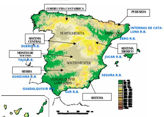
(4) Arranz, Roberto. the mountain range while the big basins of the Duero (west) and Ebro (east) flow from its south face. These mountains are a natural obstacle for the wet winds coming from the north (Cantabric Sea). Rainfall occurs at a high rate throughout the year. The Pyrenees, located in the northeast, constitute the natural frontier between Spain and France. The Spanish side of the Pyrenees is the dry south side. Winds blowing from the north are retained on the French side of the Pyrenees where they produce rain. In Spain, there are several deserts south of the Pyrenees, while other parts of the country at the same latitude are wet. Most of the rivers that originate in the Spanish Pyrenees are tributaries of the Ebro River. Spain's most important hydropower facilities are located in the Pyrenees. The Sistema Central divides the North and South Mesetas (~600 to 1000 m height and flat lands) and the Duero and Tajo river basins. The Sistema Iberico divides the Ebro (northeast), Duero (west), Tajo (southwest) and Jucar (east) river basins. The Montes de Toledo divide the Tajo and Guadiana river basins. The Sierra Morena divides the Guadiana (north-west) and Guadalquivir (southeast) river basins. The Sistema Betico, home to the Iberian Peninsula's highest mountain, Mulhacen Peak (~3,450 m), divides the Guadalquivir (west), Segura (east) and the South (short, steep and extremely dry) river basins. Most of Spain's rivers drain towards the Atlantic Ocean. The exception is the Ebro River Basin, Spain's largest river basin in terms of surface and water resources, which drains to the Mediterranean Sea. NORTE R.B. CORDILLERA CANTABRICA PYRENEES. INTERNAS DE CATALUNA R.B. EBRO LOWLANDS EBRO R.B.. NORTH MESETA SISTEMA CENTRAL. DUERO R.B.. SISTEMA IBERICO. MONTES DE TOLEDO. JUCAR R.B.. TAJO R.B. SOUTH MESETA SIERRA. SEGURA R.B.. GUADIANA R.B. GUADALQUIVIR LOWLANDS GUADALQUIVIR R.B.. SUR R.B. SISTEMA. Figure 1. General orography and hydrology of Spain. 46.
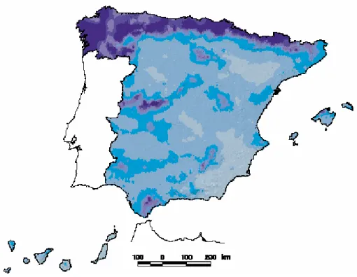
(5) Water Resources in Spain: The Ebro River Interbasin Transfer and the “Programa Agua”. 2.4. Climatology and hydrology of Spain Due to its geographic location between two huge bodies of water (the Atlantic Ocean and the Mediterranean Sea) and two continents (Europe and Africa), Spain has a diverse climate. Figure 2 shows that there is a gradient of "dryness" from the northwest (wettest) to the southeast (driest). There are 5 different climates in Spain. In the north of Spain (from Galicia to the Catalan Pyrenees) there is a Wet Oceanic climate, characterized by cool temperatures and precipitation of around 1000 mm/year, with maximum precipitation in winter and minimum precipitation in summer. In the center of Spain (the two mesetas) and the Ebro Valley there is a Continental Mediterranean climate, characterized by cold winters, hot and dry summers, and precipitation of 600 mm/year. In this area it usually rains torrentially a few days a year. In the north half of the Mediterranean area (from Gerona to Alicante), there is a Coastal Mediterranean climate, characterized by 700 mm/ year precipitation (mainly torrential rains in spring and autumn), dry winters and summers, and constant hot temperatures (no freezing period). In the southern half of the Mediterranean area (from Murcia to Almeria), there is a Dry Subtropical climate, characterized by low and irregular precipitations of less than 300 mm/year and high temperatures year-round. In southwestern Spain (western Andalucia) there is a Southwest Mediterranean climate, influenced by the cool and wet Atlantic winds. It is characterized by precipitations of 800mm/year (mainly in the spring and autumn), cool and dry winters, and comfortable summers.. Figure 2. Mean yearly precipitation (darkest color about 1000 mm and clearest color about 300 mm). 47.
(6) Arranz, Roberto. Without storage and regulation infrastructures, Spain could only use 8% of its water resources versus the 40% available in the rest of Europe with the same conditions. Thanks to more than 1,200 large dams Spain can regulate nearly 40% of its resources. In some areas like the Segura and Sur Basins, 8090% of water resources are being regulated. 2.5. Water planning and management In Spain, water is not privately owned. According to the 1985 Water Law, the “Hydraulic Public Domain” (surface, groundwater and atmospheric water and their territory: lakes, wetlands, aquifers, etc.) belongs to the nation. Water use permits (concessions) and pollution permits are issued by the River Basin Authorities. Currently there are more than 500,000 "intakes." Only half of these intakes are declared and less than a quarter are registered (El libro blanco del agua en España, 1998). Water has been managed by River Basin Authorities since the 1920's. Figure 3 shows the 14 administrative divisions and 14 River Basin Authorities. Although there are other federal, state and local institutions with competences in water, the River Basin Authorities (Confederaciones Hidrograficas) are the most important institutions for water planning and management in Spain. Some of their most important functions of the River Basin Authorities are: - Administration and control of the "hydraulic public domain". - Administration of concessions and permits. - Planning, construction and management of their own and nationally owned water systems. - Elaboration of the Basin Scale Framework Plans.. Figure 3. River Basin Authorities (Confederaciones Hidrograficas). 48.
(7) Water Resources in Spain: The Ebro River Interbasin Transfer and the “Programa Agua”. The basins shared between Spain and Portugal represent 41% of Spain's and 72% of Portugal's total surface water resources. The total resources available in these shared basins amount to 60,000 hm3, two-thirds of which is produced in Spain. The most important rivers shared are the: Mino/Minho, Limia/Lima, Duero/Douro, Tajo/Tejo and Guadiana). The first agreements between Spain and Portugal for the management of these rivers were signed in 1964 and 1968 and were only used to distribute hydropower production. In 1998 an agreement was reached for the integral and sustainable use of the shared water resources (El libro blanco del agua en España, 1998). 2.6 Water law The first Spanish Water Law was passed in the late 1870's. The 1879 Water Law was in use until 1985. Increasing problems with water quality and quantity, social conflicts, and resource degradation made it necessary to update and elaborate on the old water law. Among other important provisions, the 1985 water law stated the necessity of developing basin scale framework plans (14 plans for the 14 basins, called the Planes Hidrologicos de Cuenca) to evaluate the quantity and quality of water resources and current and future water demands as well as to plan the necessary actuations (structural and nonstructural) to achieve a sustainable use of the water resources. Also the law authorized the development of a nationwide framework plan to address issues concerning two of more river basin authorities. 2.7 Findings of the Mediterranean Basins Framework Plans (Planes Hidrologicos de las Cuencas Mediterraneas) These basin framework plans for the Mediterranean area have determined that there are structural deficits in some of the basins (Segura and Sur for example). A deficit is called structural when the natural resources are less than the demands, so these demands cannot be satisfied with only intra-basin resources. In these areas the current use of water is not sustainable. Aquifers are being overdrawn resulting in seawater intrusion problems in the coastal aquifers, surface water is over-regulated and the natural systems are degraded so that some streams and rivers only convey sewage. The national framework plan, the Plan Hidrologico Nacional, proposed an interbasin transfer project from the Ebro River to the other mediterrranean basins (Internas de Cataluna, Sucar, Segura and Sur) in order to solve the structural deficits mentioned above (Plan hidrológico nacional, 2000).. 3. The Ebro River Interbasin Transfer Project 3.1. Technical characteristics The Ebro River ITB project is basically a water diversion project designed to transfer 1050 hm3 yearly from the Ebro River to the other Mediterranean basins (Internas de Cataluna, Jucar, Segura and Sur Basins). It is composed of. 49.
(8) Arranz, Roberto. two main transmission lines (north and south), with pumping intakes placed a few kilometers upstream from the Ebro River Delta. The north line (168 km long and 11m3/s of capacity) is a closed conduit that diverts 190 hm3 yearly towards the basins of Cataluna, which primarily serve the metropolitan area of Barcelona. Water must be pumped about 250 m. The south line (746 km long and 50 m3/s of capacity) is an open canal that diverts 860 hm3 yearly towards the Jucar, Segura and Sur basins. Water must be pumped about 750 m, and about 450 m of hydropower can be produced. An intermediate reservoir has been planned for this south line. The projected capital cost of this infrastructure is ~4.2 billion euros and the project will be managed by a public agency called TRASAGUA (Plan hidrológico nacional, 2000).. Figure 4. North and South branches of the Ebro River IBT Project. 3.2. Philosophy of the Project The philosophy behind this project is that only excess water will be transferred. The current and future water rights of the donor basin and its environment will have priority. The water systems in the donor basin (more that 60 reservoirs) won't be affected and the water users in the donor basin won't notice the operation of this project. Only the operation of two hydropower reservoirs a few kilometers upstream of the intakes will be slightly modified, because only excess water will be diverted a few kilometers before it enters the Mediterranean Sea in the Ebro River Delta. The ecologic effects of the project in the Ebro River Delta have been addressed and a minimum flow requirement downstream of the project's intakes has been established to prevent the intrusion of sea water in the Delta (Horne et al, 2003). The water diverted will only be used to satisfy currently existing demands ensuring that the overdrawn aquifers and surface resources will be used in a sustainable way and never will 50.
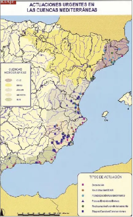
(9) Water Resources in Spain: The Ebro River Interbasin Transfer and the “Programa Agua”. be used to satisfy demands due to new irrigated agriculture or land development. Since its conception, this project has been very controversial. Communities in the donor basin (Ebro Basin) objected to the project while communities in the other Mediterranean basins strongly supported it. Furthermore, politicians and the scientific community didn't agree on the effectiveness and the social, economic and environmental impacts of the project. Despite the fact the Mediterranean states governed by the Socialist party strongly supported the project, the Socialist Party promised to abandon the project if they won the presidential elections. 3.3. Political turnover, March 2004 By the beginning of March 2004, construction had been started on the Ebro River Interbasin Transfer Project (Santos, 2004). At great expense, most of the detailed designs for the infrastructure had been done by engineering firms. The contracts for pipe and valve supplies were scheduled to be signed within a few weeks. The general elections were coming and the conservative ruling Popular Party government wanted to show its position. The future of water had been one of the cornerstone issues of the election. On March 14, 2004 the Socialist Party won the presidential elections. A few days later, the new president, Rodriguez Zapatero, announced that the Ebro River IBT project was going to be abandoned. Soon thereafter Zapatero presented an alternative called the "Programa AGUA".. 4. The alternative: the "Programa Agua" The "Programa AGUA 2004-2008" is the alternative to the Ebro River IBT presented by the Socialist Party government. It is intended to solve the water scarcity problem in the Mediterranean area and create institutional and legal reforms that are applicable to the whole country. Instead of diverting water from the Ebro River, the program advocates water reuse and seawater desalination. The main proposals of the "Programa AGUA" are: • Reform of the river basin authorities ("Confederaciones Hidrograficas") to promote autonomous government and public participation. • Water banks will be created in every river basin to promote the equitable, sustainable, and efficient reassignment of water rights. • Water charges will reflect the real cost of providing the service, according to the European Framework Law. No subsidies will be allowed. • Rather than developing conventional sources, reuse and desalination of water will be promoted to solve existing problems. The specific problem addressed by the Ebro River IBT will be solved with a series of more than 100 actions (mainly WWTP improvement to promote the reuse and seawater desalination, see figure 5). The estimated cost of these actuations is about 3.9 billion euros.. 51.
(10) Arranz, Roberto. Figure 5. The “Programa Agua” proposed to substitute the Ebro River IBT Project. 5. Conclusions In Spain, political parties have determined the course of nationwide water planning. The pros and cons of the Ebro River IBT and the "Programa Agua" have been frequently exaggerated by politicians, decision makers and other stakeholders depending on their own interests or political affiliations.. 52.
(11) Water Resources in Spain: The Ebro River Interbasin Transfer and the “Programa Agua”. References Horne, A. J., Dracup, J., Hanemann, M., Rodriguez-Iturbe, I., Means, E. and Roth, J.C., 2003: A technical review of the Spanish Hydrological Plan (Ebro River outof-basin diversion). Unpublished manuscript. Ministerio de Medio Ambiente, Madrid, 1998: El libro blanco del agua en España. (Spanish Ministry of Environment, 1998: The white book of water in Spain). Ministerio de Medio Ambiente, Madrid, 2000: Plan hidrológico nacional (PHN). Volúmenes 1, 2, 3, 4 and 5. (Spanish Ministry of Environment, 2000: National hydrological plan, Volumes 1, 2, 3, 4 and 5). Santos, R. Revista Ambienta. Ministerio de Medio Ambiente, Marzo-Abril 2004: Comienzan las obras. (Santos, R. Ambienta Magazine. Spanish Ministry of Environment, March-April 2004: Comienan las obras) Torres, M. Revista Ambienta. Ministerio de Medio Ambiente, Julio-Agosto 2004: La desalacion de agua de mar y el vertido de la salmuera. (Torres, M.Ambienta Magazine. Spanish Ministry of Environment, July-August 2004: La desalacion de agua de mar y el vertido de la salmuera). Ministerio de Medio Ambiente, 2004: pagina web del Programa Agua. (Spanish Ministry of Environment, 2004: website of the "Programa Agua") http://www.mma.es/agua/entrada.htm.. 53.
(12)
Figure

+2
Related documents
46 Konkreta exempel skulle kunna vara främjandeinsatser för affärsänglar/affärsängelnätverk, skapa arenor där aktörer från utbuds- och efterfrågesidan kan mötas eller
The increasing availability of data and attention to services has increased the understanding of the contribution of services to innovation and productivity in
Generella styrmedel kan ha varit mindre verksamma än man har trott De generella styrmedlen, till skillnad från de specifika styrmedlen, har kommit att användas i större
Parallellmarknader innebär dock inte en drivkraft för en grön omställning Ökad andel direktförsäljning räddar många lokala producenter och kan tyckas utgöra en drivkraft
Närmare 90 procent av de statliga medlen (intäkter och utgifter) för näringslivets klimatomställning går till generella styrmedel, det vill säga styrmedel som påverkar
4 Is it possible to establish temperature and precipitation boundaries for suitable páramo environments, based on interpolated historical observations? Will the studied páramo
This report aims to estimate the available water resources in the Zambezi River Basin, per country and as a whole, and, by creating future climate change
Industrial Emissions Directive, supplemented by horizontal legislation (e.g., Framework Directives on Waste and Water, Emissions Trading System, etc) and guidance on operating
