Image in Renaissance Guidebooks to
Ancient Rome
Rome fut tout le monde, & tout le monde est Rome1
Drawing in the past, drawing in the present: Two
attitudes towards the study of Roman antiquity
In the early 1530s, the Sienese architect Baldassare Peruzzi drew a section along the principal axis of the Pantheon on a sheet now preserved in the municipal library in Ferrara (Fig. 3.1).2In the sixteenth century, the Pantheon was generally considered the most notable example of ancient architecture in Rome, and the drawing is among the finest of Peruzzi’s surviving architectural drawings after the antique.
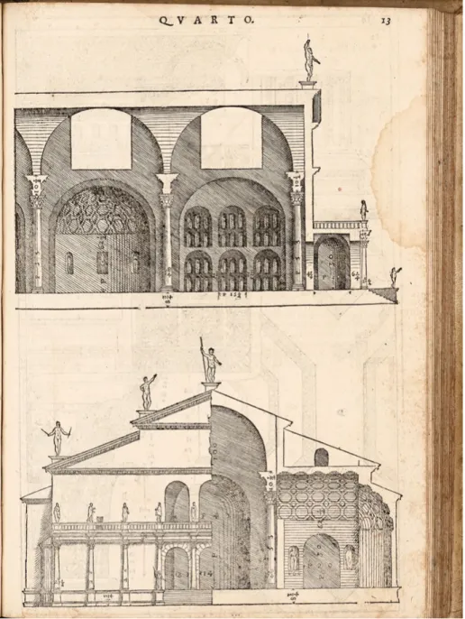
The section is shown in orthogonal projection, complemented by detailed mea-surements in Florentine braccia, subdivided into minuti, and by a number of expla-natory notes on the construction elements and building materials. By choosing this particular drawing convention, Peruzzi avoided the use of foreshortening and per-spective, allowing measurements to be taken from the drawing. Though no scale is indicated, the representation of the building and its main elements are perfectly to scale. Peruzzi’s analytical representation of the Pantheon served as the model for several later authors– Serlio’s illustrations of the section of the portico (Fig. 3.2)3and the roof girders (Fig. 3.3) in his Il Terzo Libro (1540) were very probably derived from the Ferrara drawing.4
In an article from 1966, Howard Burns analysed Peruzzi’s drawing in detail, and suggested that the architect and antiquarian Pirro Ligorio took the sheet to Ferrara in 1569. According to Burns, the article on‘Pantheon’ in the thirteenth volume of the manuscript encyclopaedia of classical antiquity, which Ligorio compiled in Ferrara (now preserved in Turin), confirmed the hypothesis that Ligorio owned the drawing: on a double page spread, Ligorio copied Peruzzi’s section of the Pantheon, and on the
1 Du Bellay (1558) XXVI. 9; see Tucker (1990).
2 Ferrara, Biblioteca Comunale Ariostea, ms. Classe I 217, allegato 8r, Baldassare Peruzzi, Pantheon;
Burns (1966); Kleefisch-Jobst (1994).
3 Serlio adds a pilaster in the corner nearest the door of the short vestibule between the portico and the rotunda, an emendation to the standing building made by Peruzzi in the Ferrara drawing. 4 Serlio (1540) IX–XII; for Serlio’s printing enterprise, Carpo (2001) 42–55.
reverse of the second page the study of the cornice above the door, which the Sienese architect had drawn down the side of the Ferrara sheet (Fig. 3.4).5
The measurements of the two drawings correspond exactly, as do some of the notes. Although Ligorio copied from Peruzzi, he made certain interpolations that marked his own knowledge of the building and the ancient sources related to it. Behind the Pantheon he added a reconstruction of the façade of the basilica of Neptune (which he mistakenly identified as the “Tempio di Benevento”), and he replaced the haloed figure that Peruzzi had drawn above one of the columns of the “cappella maggiore” with a statue of Minerva.6Ligorio’s drawing was an attempt to reconstruct the appearance of the building in antiquity, and not a survey of the surviving monument. Ligorio sought to give the building an antique flavour, finish-ing all the parts of his drawfinish-ing to the same level (addfinish-ing for example the rosettes in Fig. 3.1: Baldassare Peruzzi, section across the principal axis of the Pantheon, c.1530, Ferrara, Biblioteca Comunale Ariostea, ms. Classe I 217, allegato 8r(Photo Municipal library of Ferrara).
5 Turin, Archivio di Stato, Biblioteca antica, Manoscritti, Ligorio Pirro, Il libro delle antichità, vol. 13, fols. 48v–49r, 49v, published in Burns (1966) as Figs. 3.13 & 3.14. The same article also has Ligorio’s copies of the four studies of the Pantheon in the Uffizi by Giovanni Antonio Dosio (Gabinetto Disegni e Stampe, 2020A, 2021A, 2022A & 2023A). For Dosio’s drawings of the Pantheon, Hülsen (1933) xiv–xvii; Borsi et al. (1976) 112–13, nos 104–107; for Ligorio’s manuscripts in Turin, see Mandowsky/Mitchell (1963).
Fig. 3.2: Sebastiano Serlio, Terzo Libro (1540), XII, Pantheon, longitudinal section of the portico (Photo Bibliotheca Hertziana– Max-Planck-Institut für Kunstgeschichte).
Fig. 3.3: Sebastiano Serlio, Terzo Libro (1540), X, Pantheon, roof girder and transverse section of the portico (Photo Bibliotheca Hertziana– Max-Planck-Institut für Kunstgeschichte).
Fig. 3.4: Pirro Ligorio, section across the principal axis of the Pantheon, Turin, Archivio di Stato, Biblioteca antica, Manoscritti, Ligorio Pirro, Il libro delle antichità, vol. 13, fols. 48 v – 49 r (Photo Archivio di Stato di Torino).
the coffering), but with less attention to accurate detail than Peruzzi (the bases of the columns are out of scale, for example, and the coffering is recessed too far into the vault). Ligorio’s sense of what was most relevant in the representation of an ancient building differed considerably from the outlook implicit in Peruzzi’s drawing. Ligorio tended to interpret the building in terms of literary sources and his general concep-tion of the antique. As Burns acutely notes,“Peruzzi draws the Pantheon, as it were, in the present. But Ligorio draws it in the past, by furnishing it with a rich antique décor”.7
A comparison of Peruzzi’s and Ligorio’s depictions of the Pantheon helps us see two attitudes towards the study of antiquity that coexisted in sixteenth-century Rome, and that characterised not only the production of architectural drawings and treatises, but also guidebooks and cartographic representations of the city.8 The first, by such architects as Leon Battista Alberti, Raphael, Sebastiano Serlio, Andrea Palladio, Giovanni Antonio Dosio and the antiquarians Flavio Biondo, Andrea Fulvio, Bartolomeo Marliano and Bernardo Gamucci, con-tributed to the formation of a historically truthful image of the city, in which past and present harmonised.9The second, illustrated by the work of the architects and antiquarians Pirro Ligorio, Giovanni Battista Montano, and later Giacomo Lauro, set out to resurrect ancient Rome, creating an imaginative and captivating picture of the Eternal City.10 The present essay concerns the first of the two attitudes, which, acknowledging the primacy of empiricism, drove the transfor-mation of antiquarian studies and architecture into modern disciplines.
The architectural historian Cammy Brothers has highlighted the concern architects and antiquarians shared for Roman ruins in the sixteenth century.11 While architects were fascinated by the particular physical qualities of the ruins, antiquarians devoted their energies to understanding their original function and history. The result, Brothers argues, was “a strange disjunction, unfamiliar to students of architecture or historians of art today, who are accustomed to well-illustrated historical studies: one could learn about ancient architecture by examining large numbers of drawings and prints after ancient architecture that provided little or no commentary; or one could read the guidebooks,
7 Burns (1966) 267.
8 For sixteenth-century descriptions of ancient Rome, see Siekiera (2009) and Siekiera (2010); see also Delbeke/Morel (2012); and Kritzer (2010), who shows how guidebooks authors built on previous works and reluctantly questioned the authority of classical sources.
9 For Renaissance archaeology and antiquity, see, for example, Cantino Wataghin (1984); Barkan (1999).
10 Fuhring (2008); for Montano, see Bedon (1983); Fairbairn (1998) 541–54; Dallaj 2013; for Lauro, see Plahte Tschudi (2017).
which failed to offer a sense of what the monuments look like”.12 Around 1550, however, common features such as an emphasis on first-hand experience of material remains, and on the role of images as visual sources, indicated that guidebooks and architectural treatises were exerting a distinct mutual influence on one another. The antiquarians’ collecting and study of inscriptions and medals provided architects with a growing body of historically correct informa-tion about the topography of the ancient city, while the investigainforma-tions of the architectural ruins undertaken by several generations of Renaissance architects supplied antiquarians with increasingly accurate surveys and visual reconstruc-tions of the monuments. The exponential growth of the printing market in sixteenth-century Rome also persuaded architects and antiquarians into a num-ber of joint publishing ventures. Woodcuts, etchings, and copperplate engrav-ings of real and fantasy buildengrav-ings, initially conceived as illustrations of architectural treatises or as single-leaf prints, were re-engraved in smaller for-mats as guidebook illustrations. Before the 1540s, no guidebook to Rome, ancient or modern, was illustrated. It was the antiquarian Bartolomeo Marliano who in 1544 published the very first illustrated guidebook to ancient Rome, the Urbis Romae topographia, which borrowed a number of plates from Sebastiano Serlio’s architectural treatise on antique architecture, Il Terzo Libro (1540). Marliano’s guidebook paved the way for a new type of publication in which images and text complemented one another, in what was plainly an attempt to amuse readers, but also to help them understand. The work of the subsequent generation of architects, and in particular Andrea Palladio and Pirro Ligorio, widened the visual representations of ancient architecture in type and quality, while at the same time the Roman market for individual intaglio prints offered a great range of subject matter, including maps. Yet it was probably the views of the antiquities of Rome drawn by Giovanni Antonio Dosio, and printed as illustrations of Gamucci’s L’Antichità di Roma (1565) and de Cavalieri’s Urbis Romae aedificiorum illustrium quae supersunt reliquiae summa (1568), that con-tributed most to the changes in the guidebook tradition, by subverting the relationship between text and image in favour of the latter.
From Biondo to Fulvio: Towards a systematic survey
of the ancient city
The rise of Renaissance antiquarianism in the fifteenth century marked a turning point in classical studies, and consequently in descriptions of the ancient city of
Rome. A new approach to sources led to a critical assessment of the so-called Mirabilia, descriptions of Rome deriving from a twelfth-century prototype, which relegated them to the category of popular literature.13Artists, architects and antiquarians began to study ancient monuments in a novel way, combining on-site scrutiny of the ruins with the philological reading of classical sources, the interpretation of ancient inscriptions, and the use of old coins for historical evidence.14Biondo (1392–1463) was the first to attempt a methodical account of the remains of the ancient city.15His main work, De Roma instaurata, published in three volumes between 1444 and 1446, was a topogra-phical reconstruction of the urban and architectural setting of ancient Rome, which deeply influenced all the guidebooks to Rome until the end of the sixteenth century. Its structure conformed to a catalogue of the urban regions of the city attributed to Sextus Rufus, which in turn directly or indirectly derived from the fourth-century catalogue by Publius Victor, Descriptio urbis Romae.16The structure of the late antique regionary catalogues helped Biondo establish an exact topographical standpoint for the descrip-tion of the ancient city; however, Biondo’s description was also perfectly integrated into the fabric of Christian Rome and its monuments. The first volume of De Roma instaurata dealt with the gates of the town, describing both the Aurelian walls and the ninth-century circuit of the Civitas Leonina. Then Biondo proceeded to examine the Vatican district with its pagan and Christian monuments: St Peter’s and the hospital of Santo Spirito in Sassia, the Capitoline Hill, the Aventine, the Palatine, the Caelian, the Basilica Salvatoris and the areas around the Lateran hospital, and concluding with the Esquiline, the Quirinal, and the Suburra. The second volume started with a disquisition on ancient baths, followed by descriptions of pagan and Christian monuments on the Esquiline and Viminal hills, and concluded with an account of the city’s religious and administrative monuments and theatres. Amphitheatres and circuses opened volume three, which then concentrated on the arches and other buildings of the Forum, the Pantheon, and other miscellaneous monuments. Not long after the publication of Biondo’s De Roma instaurata, the architect Leon Battista Alberti (1404–1472) devel-oped a method for a systematic survey of the cityscape, exemplified in his Descriptio urbis Romae.17This was the first topographic description of the city based on a set of
13 For the Mirabilia, see Accame/Dell’Oro (2004); Huber-Rebenich et al. (2014). 14 Weiss (1973) 59–72; Franzoni (2001); Blevins (2007); Karmon (2011). 15 McCahill (2013); Mazzocco (2016); Günther (1997).
16 Flavio Biondo declares to have consulted an old description of Rome by Sextus Ruffus vir consularis, a copy of which he had seen in the library attached to the monastery of Monte Cassino. See Smith (1873), s.v.“Sextus Rufus”.
17 Alberti worked on the Descriptio between 1448 and 1455. Six manuscript copies of the work survive. For modern editions, see, for example, Alberti (2000); Alberti (2005); Carpo/Furlan (2007). For Alberti and the Descriptio in general, see Di Teodoro (2005).
exact measurements, taken with the aid of a mathematical instrument, between a number of principal landmarks and monuments and the Capitol, conceived as umbi-licus urbis.18Alberti’s Descriptio circulated only as in manuscript, but nonetheless set a new standard in the way Rome and its monumental palimpsests were identified and represented by cartographers. The recognition of the Capitoline Hill as the epicentre of the ancient city was one borrowed by later descriptions of Rome, such as the influential Topographia Antiquae Romae by Bartolomeo Marliano (1534).
After Biondo’s and Alberti’s pioneering work, it was in the age of Leo X (1513–1521) that antiquarian studies saw major progress. During his eight-year pontificate, the Medici Pope encouraged research by antiquarians around the city, and involved artists and architects in order to correlate their findings.19At the Pope’s behest, Raphael began a project to draw up a map of ancient Rome, complete with texts and drawings of all its monuments.20The method and principles he used in this ambitious undertaking were clearly stated in the famous memorandum to Leo X, written in collaboration with Baldassare Castiglione in around 1519.21The letter, which survives in several manuscript copies, concerned the preservation of the ancient monuments of Rome, and included a progress report on the artist’s work. Raphael’s intention was to combine a detailed survey of the standing ruins with a reading of the ancient sources.22 Aware of its limits as an empirical method, he had not set out to compile a complete image of antiquity, but“a drawing of ancient Rome – at least as far as can be under-stood from that which can be seen today– with those buildings that are sufficiently well preserved such that they can be drawn out exactly as they were, without error, using true principles, and making those members that are entirely ruined and have completely disappeared correspond with those that are still standing and can be seen.”23
In the letter, Raphael clarified how to distinguish ancient buildings from the “Gothic” (medieval) and the modern (Renaissance) buildings, in order to survey them ‘without making mistakes’.24His technique was based on a magnetic compass, and
18 For a description of Alberti’s instrument for measuring angles, see Williams/March/Wassell (2010) 122–3.
19 Tafuri (1984); Danesi Squarzina (1989); Jacks (1993) 183–91 et passim.
20 For Raphael and the study of the antiquity, see Burns (1984); Nesselrath (1984).
21 Bonelli (1978) 461–84; Rowland (1994); Di Teodoro (2003). For the English translation, see Hart/ Hicks (2006) 177–92.
22 “Since I [Raphael] have been so completely taken up by these antiquities – not only in making every effort to consider them in great detail and measure them carefully but also in assiduously reading the best authors and comparing the built works with the writings of those authors– I think that I have managed to acquire a certain understanding of the ancient way of architecture” (Hart/ Hicks 2006, 179); for Raphael’s archaeological method, see Nesselrath (1986).
23 Hart/Hicks (2006) 181. 24 Ibid. 183.
he explained its use in detail. Regarding the method of architectural rendering, Raphael described how to proceed from a measured ground plan to section and exterior elevation, following Vitruvius’ classification of ichnographia, orthographia, and scaenographia.25Clearly, Raphael intended to draw in the present, developing a modern archaeological method of enquiry, characterised by Arnold Nesselrath as “opposed to the mere general antiquarian interests which were common practice among students of the antique of his own and later time”.26Unluckily, only a few drawings after antique architecture by Raphael have survived (Fig. 3.5), but his method can be traced in the work of his pupils and followers, among whom were Baldassare Peruzzi (who opened this essay) and Antonio da Sangallo the Younger.27 In the preface to his Antiquitates urbis (1527), the historian and antiquarian Andrea Fulvio reported that he joined Raphael in charting ancient Rome.28He Fig. 3.5: Raphael, perspective view of the interior of the Pantheon, c.1506, Florence, GDSU, 164A (Photo Public domain Wikimedia commons).
25 Fra Giocondo (1511) Liber I, Caput II, fol. 4. 26 Nesselrath (1986) 358.
27 For Raphael’s drawings after antiquity, see Frommel et al. (1984) 417–23. 28 On Fulvio see Weiss (1959).
said that he went about with the artist, examining the ruins of Rome region by region (“per regione explorans”),29 and saw how Raphael located and identi-fied the sites of the monuments and carefully drew their remains (“Raphael Urbinas pennicillo fixerat”).30Raphael’s premature death in April 1520 brought their joint project to an abrupt stop, but Raphael’s programme was resumed in Fulvio’s Antiquitates, whose scope was “to preserve the memory of the ancient monuments from destruction”.31 Fulvio’s description of ancient Rome was based on the evidence of the surviving ruins, but also on literary and epi-graphic sources and coins. His perspective, he explained, was that of a histor-ian, not of an architect: “non vero architectus, sed historico more describere curavi”.32His appreciation of the ancient monuments as an integral part of the Renaissance city did not differ from Raphael’s, but, unlike their joint efforts, Fulvio chose not to impose a topographical structure on his Antiquitates urbis. Confronting the tradition of the late antique regionary catalogues, resurrected in Biondo’s work, Fulvio instead grouped Roman antiquities according to type (city gates, bridges, aqueducts, baths, forums, triumphal arches, theatres, columns, obelisks, and so on), offering a precise overview of what was still visible at the time. Fulvio did not draw in the present, he described in the present, and thus he told the reader about an excavation he had participated in, noted modern restorations of antique buildings, and detailed how pieces of sculpture and fragments from vigne and gardens had been moved into palaces and courtyards. In his description of ancient Rome, he also included modern monuments (the Capitoline Hill, New St Peter’s, the Ginnasio Romano, alias the Studium Urbis) and artworks worthy of praise (Giotto’s Navicella mosaic and the Filarete door in St Peter’s, the bronze funerary monuments of Martin V in San Giovanni and of Sixtus IV and Innocent VIII in St Peter’s, Raphael’s Vatican loggias, the Vatican Library, and others). Published in 1527, the city’s annus horribilis, the Antiquitates initially did not receive the attention it deserved, most likely because of the turmoil following the Sack of Rome in which Fulvio apparently died.33Nonetheless, the fortune of Fulvio’s work was demonstrated by the appearance in 1543 of an Italian translation by Paolo del Rosso, published in Venice as Delle antichità della città di Roma, and by the influence of this vernacular edition on later guidebooks, and in particular Andrea Palladio’s 1554 L’antichità di Roma.34
29 Fulvio (1527) fol. A1. 30 Ibid.; also Jacks (1993) 190. 31 Fulvio (1527) fol. A1. 32 Ibid.
33 Ceresa (2004). 34 Daly Davis (2007).
Monuments as visual evidence: Serlio and Marliano
Sebastiano Serlio’s Il Terzo Libro, nel quale si figurano, e descrivono le antiquità di Roma, published in Venice in 1540, and the 1544 edition of Bartolomeo Marliano’s guidebook to ancient Rome, the Urbis Romae topographia, together form one of the most interesting cases of mutual influence between an architectural treatise and a description of ancient Rome. Serlio’s book was devoted to ancient architecture and included 53 buildings located in and outside Italy, grouped according to seven main typologies: temples and basilicas (Fig. 3.6), theatres, amphitheatres, baths, trium-phal arches (Fig. 3.7), villas, and palaces. Other types of structures, such as triumtrium-phal columns, obelisks, portals, bridges, and pyramids, were represented by one monu-ment only. As persuasively argued by the art historian Hans-Christoph Dittscheid, Vitruvian theory appears to have played only a minor role in Serlio’s Il Terzo Libro.35In fact, monuments such as obelisks, triumphal columns, and arches were not treated in Vitruvius’ Ten books on Architecture, and neither were they in modern architectural treatises that relied on Vitruvius, such as Alberti’s De re aedificatoria (first published in 1485). They were nonetheless usually included in major descriptions of ancient Rome– the works of Varro and Biondo being the obvious examples. In Il Terzo Libro, Serlio also described a number of Renaissance buildings (St Peter’s, Bramante’s Tempietto at San Pietro in Montorio, the Vatican Belvedere, Villa Madama), which, in his view, rivalled ancient architecture. With this inclusion, Serlio showed that he was not interested in reconstructing ancient Rome as it once was, but in presenting the monuments of the past within the context of the modern city, hence following in the footsteps of Biondo and Fulvio and prefiguring the type of guidebook to Roma antica e moderna that would appear in the seventeenth century.36Written in the vernacular and addressed to a large audience, Serlio’s treatise also anticipated by several years the stream of translations from Latin into Italian of the most important descriptions of ancient Rome issued in the fifteenth and early sixteenth centuries: Flavio Biondo’s De Roma instaurata and De Roma triumphante (published in translation in 1542); Andrea Fulvio’s Antiquitates (translated in 1543); Bartolomeo Marliano’s Urbis Romae topographia (translated in 1548).37 Yet the most influential feature of Serlio’s treatise was its large-scale illustrations. Indeed, Serlio’s information is primarily conveyed through his images rather than the text.38The primacy Serlio gave the images is clearly stated in his dedication to Francis I of France and35 Dittscheid (1989).
36 The first guidebook that combined descriptions of ancient and modern Rome was Giovanni Domenico Franzini, Roma antica e moderna, published in 1643; Schudt (1930) 46–8; Delbeke (2012). 37 Siekiera (2010).
Fig. 3.6: Sebastiano Serlio, Terzo Libro (1540), XXIII, Basilica of Maxentius, plan (Photo Bibliotheca Hertziana– Max-Planck-Institut für Kunstgeschichte).
Fig. 3.7: Sebastiano Serlio, Terzo Libro (1540), CXI, Arch of Septimius Severus, elevation (Photo Bibliotheca Hertziana– Max-Planck-Institut für Kunstgeschichte).
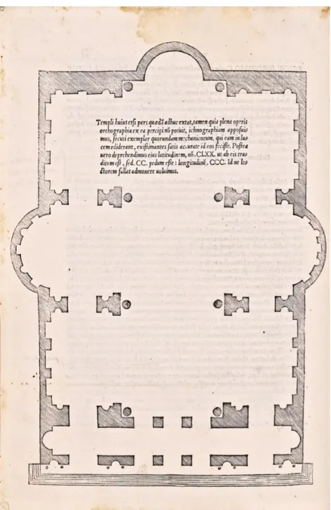
reaffirmed in the first chapter, devoted to the Pantheon.39Having summarised the information about the Pantheon given by ancient writers, Serlio commented:“but leaving aside these narrations, which have little importance to the architect, I shall come to the particular measurements of all the parts”, illustrated by the plan, elevation, and section of the monuments.40 Until Serlio published his Il Quarto Libro in 1537, the only illustrated books on architecture printed in Italy were editions of Vitruvius such as those by Fra Giocondo (1511) and Cesare Cesariano (1521).41Torello Saraina’s book on the origins and history of Verona, illustrated with 31 woodcuts of its Roman antiquities to designs by Giovanni Caroto, appeared in 1540, the same year as Serlio’s Il Terzo Libro was published.42 The layouts of Fra Giocondo’s and Cesariano’s books were characterised by a combination of text and illustration, while Saraina and Serlio also introduced full-page illustrations placed in close proximity to a descriptive text (Fig. 3.6). Serlio depicted monuments in plan, section, and elevation, sometimes in one plate, sometimes in different folios, as in the illustrations of the Pantheon (Figs. 3.2–3.3). Cross-sections of building interiors and details of the orders were repre-sented for the first time in an orthogonal projection. Measurements were not recorded in the images, but in the text. In his woodcuts, Serlio adopted the method of surveying the ancient monuments developed by Raphael and Peruzzi, and in some cases he directly copied Peruzzi’s drawings, as for example in the orders of the Temple of Mars Ultor in the Augustan Forum.43
There can be little doubt that it was the publication of Serlio’s book Il Terzo Libro that encouraged Bartolomeo Marliano to complement the second edition of his Urbis Romae Topographia (1544) with images of ancient monuments.44Of the fifteen wood-cuts that illustrated the volume, eight were taken straight from Serlio’s plates: the Arch of Septimius Severus (Fig. 3.8), the Basilica of Maxentius also known as Templum Pacis (Fig. 3.9), the Arch of Janus, Trajan’s Column, the Pantheon, the Pons Fabricius, the Vatican Obelisk, and the church of Santa Costanza.45
39 Serlio (1540) III: “acciocchè qualunque persona, che di Architettura si diletta; potesse in ogni luogo, ch’ei si trovasse, togliendo questo mio libro in mano, veder tutte quelle meravigliose ruine de i loro edifici: le quali non restassero anchor sopra la terra; forse non si darebbe tanta credenza a le scritture, le quali raccontano tante maraviglie di i gran fatti loro”.
40 Serlio (1540) VI. 41 Rosenfeld (1989).
42 Saraina/Caroto (1540); Caroto (1977).
43 See Peruzzi’s drawing, GDSU 632Av; Serlio (1540) LXXXV.
44 Marliano (1544). The first edition of Marliano’s Topographia was published in 1534 with no illustrations, except for the plan of the ancient city. For Marliano see Jacks (1993) 208–14; and Plahte Tschudi’s contribution to the present volume.
45 The other seven illustrations – not taken from Serlio’s treatise – represent the temples of Antoninus and Faustina, Portunus, and Hercules Victor, the Circus Maximus, the Pyramid of Caius Cestius, the Septizonium, and the Curia Hostilia.
Fig. 3.8: Bartolomeo Marliano Urbis Romae Topographia (1544), 39, Arch of Septimius Severus, elevation. (Photo Bibliotheca Hertziana– Max-Planck-Institut für Kunstgeschichte).
Fig. 3.9: Bartolomeo Marliano Urbis Romae Topographia (1544), 46, Basilica of Maxentius, plan. (Photo Bibliotheca Hertziana– Max-Planck-Institut für Kunstgeschichte).
In his envoi addressed to the reader, Marliano thanked Ludovico Lucena and Orazio Nucleo for their help, as they had provided the supplemental images for the new edition.46 But he also claimed that Topographia’s plates were far superior to those engraved by previous authors:“I am not unaware that some of these [monu-ments] have been published by those who chiefly assume the title of architects. Nevertheless, seeing as even I have produced something carelessly before, I have discovered that they have done so, and I have decided it would be for the common benefit of all studious men if I were to insert these [monuments] emended and graphically delineated into this volume”.47 Marliano’s volume was not the first illustrated description of ancient Rome, but it was the first to present archeologically correct reconstructions of its monuments. Back in 1527, Fabio Calvo (the author of a translation of Vitruvius used by Raphael) had published Antiquae Urbis Romae cum Regionibus simulacrum, which had two series of plates, one reconstructing the topography of the ancient city from its foundation to the Flavian Age, the other illustrating the fourteen Augustan regions, followed by images of the Capitol, a circus, and a balneum.48 Although a brave stab, Calvo’s representations of the ancient monuments were inaccurate and schematic, taken as they were from manu-scripts and coins.49Similarly, his topographic images of the ancient city derived from a number of literary source, with no reference to the evidence of the ruins. Very different from Marliano then, whose main concern was“to thread a new and clearer path in locating ancient monuments”, that is to situate them with precision into the fabric of the modern city.50 In his Topographia, each monument is accurately described with reference to present landmarks, such as churches, palaces, and squares; and indeed, in his narrative Marliano addressed the modern reader, con-stantly evoking an immediate, visual experience of the cityscape, an approach that he clearly shared with Serlio and the architects of Raphael’s generation.
Experience and erudition: Andrea Palladio from
L
’antichità di Roma to I quattro libri dell’architettura
In 1554, during his fifth journey to Rome with his patron, the Venetian patrician Daniele Barbaro, Andrea Palladio published two guidebooks, one devoted to the
46 Marliano (1544) 121.
47 Ibid., translated in Jacks (1993) 209. 48 Pagliara (1976).
49 For Calvo’s Simulacrum and its sources, see Jacks (1993) 191–204.
50 Marliano (1544) 2: “Nos tamen viam aliam planiorem, certioremque ingressi hanc secundam editionem eo adduximus… ut unumquodque aedificium in qua parte positum fuerit, hodieque extet, facile dignosi possit”.
ancient city, entitled L’Antichità di Roma,51 the other dedicated to modern Rome, called Descrizione della chiese di Roma.52In contrast to the Descrizione, which was arranged as four itineraries, Palladio’s L’Antichità treated the general topography of the ancient city and presented a catalogue of Roman buildings and sites, listed according to their typology: gates, roads, bridges, hills, aqueducts, baths, circuses, theatres, columns, basilicas, and others. Palladio’s two guidebooks were probably intended to be used together, showing a distinctly pragmatic attitude on the part of the architect. How best to lead a traveller through ancient Rome, whose vestiges laid partly unexcavated in the open fields between the settlements of the medieval and modern Rome? In L’Antichità di Roma Palladio thus offered the reader an encyclo-paedic catalogue of the ancient monuments, to be browsed during a visit to the modern city and its churches, or to consult anywhere as a source of historical information. The 64 editions of L’Antichità di Roma that followed between 1554 and 1750 demonstrate the power of Palladio’s intuition. The reasons of this extraordinary success lay in the book’s accessibility, the choice of the vernacular, the accuracy of the historical and archaeological information, the brevity of the text (only 32 sheets), the visual clarity of the layout, the handy index, and the portable, pocket-sized octavo format.
In the preface to L’Antichità di Roma, Palladio affirmed that his ambition was to establish a‘truer’ picture of the past, founded on the authority of “many completely reliable authors, both ancient and modern”, whose names he explicitly recorded.53 Yet, he claimed,“I did not rest there. I also wished to see and measure everything with my own hands in minute detail”.54By the mid-1550s Palladio’s collection of surveyed drawings of Roman buildings was extensive.55He was already working on three of the books that would evolve into the Quattro Libri (published 1570), and he was providing illustrations for Daniele Barbaro’s 1556 translation of Vitruvius.56If, as suggested by Robert Tavernor, Barbaro and Palladio intended the reader to regard their books – I dieci libri dell’architettura di M. Vitruvio and the Quattro Libri, respectively– as parallel texts,57Palladio’s guidebook to ancient Rome may also
51 The first edition of Palladio’s book was published in Rome in 1554 by Vincenzo Lucrino and in Venice by Matteo Pagan. Schudt (1930) 379–86. An English commented translation has been pub-lished by Vaughan Hart and Peter Hicks: Hart/Hicks (2006). An authoritative commentary of Palladio’s work is Davis (2007). See also Fiore (2008).
52 Palladio (1554). Modern English translation: Hart/Hicks (2006) 95–176.
53 Among the ancient authors, Palladio names Dionysius of Halicarnassus, Livy, Pliny, Plutarch, Appian of Alexandria, Valerius Maximus, Eutropius; among the moderns, Flavio Biondo, Andrea Fulvio, Lucio Fauno, Bartolomeo Marliano.
54 Palladio (1554), 1, translated in Hart/Hicks (2006) 3.
55 For Palladio’s drawings after antique architecture, Zorzi (1959); Avagnina/Villa (2007) 121–47. 56 Barbaro (1556); Puppi (1988) 71–105; Cellauro (1998); for Palladio, Vitruvius, and the study of antiquity, see Gros (2006); Gros (2008).
have found its theoretical background and visual complement in Barbaro’s edition of Vitruvius.
In fact, Palladio’s guidebook lacked illustrations and little of the results of the architect’s own survey of the Roman monuments was reported in the text.58Only occasionally did Palladio record precise measurements, as for the Cloaca Maxima, “the Cloaca, or what we call the main sewer, was near the Pons Senatorius, now called the Ponte di Santa Maria. It was built by Tarquinius Priscus, and its great size was recorded with wonder by writers, in that inside it was large enough for a cart to pass comfortably through. As for myself, I have measured it and find that it is 16 feet wide”.59Nonetheless, Palladio stands out by giving an account of the present condi-tion of each monument:“there were seven aqueducts in Rome. The most famous was that for the Aqua Marcia, the remains of which can be seen in the road that goes to San Lorenzo fuori le Mura. That for the Aqua Claudia used to go from the Porta Maggiore to the church of San Giovanni in Laterano. This aqueduct went via the Celian Hill to the Aventine, and today its half-collapsed arches can still be seen rising to a height of 109 feet.”60In the text, the repeated use of the word today reconnected the Roman remains to the architect’s own time and experience: “A great deal of the Portico of Faustina is still there on the site where today stands the church of San Lorenzo in Miranda. The Portico of Concord, with its eight columns, stands comple-tely intact on the small hill of the Campidoglio. Next to this there once stood another much larger portico, built as ornament for the Campidoglio; all that remains are three columns”.61In his guidebook, Palladio also reported recent discoveries, as in the paragraph on obelisks or“needles”: “As for the small ones, there used to be 42 of them, and on most of these there were Egyptian characters. Today, however, only two stand, one in the Aracoeli and the other at San Ma[c]uto. Six years ago another was found in a small house behind the Minerva, while they were digging a cantina”.62
Palladio’s programme in L’antichità di Roma – combining the authority of tradi-tion with first-hand experience of the ancient ruins– was extremely significant as a method, as he himself asserted in the preface to his major work, I Quattro Libri dell’architettura, published in 1570: “because I ever was of the opinion, that the ancient Romans did far excel all that have come after them, as in many other things so particularly in building, I proposed to myself Vitruvius both as my master and
58 Margaret Daly Davies (2007, 177–81) argues that Palladio’s intention for publishing such a scholarly book was probably to establish his own reputation as an architect of humanist formation. At the same time, she questions the autography of Palladio’s guidebook. She notes that in one of his later manuscripts Ligorio claimed that L’Antichità di Roma was not written by Palladio, but by the historian Giovanni Tarcagnota, alias Lucio Fauno alias Lucio Mauro. Indeed, it is quite possible that the book was the result of Palladio’s collaboration with a knowledgeable antiquarian.
59 Hart/Hicks (2006) 27. 60 Ibid. 27
61 Ibid. 46. 62 Ibid. 51.
guide, he being the only ancient author that remains extant on this subject. Then I betook myself to the search and examination of such ruins of ancient structures as, in spite of time and the rude hands of Barbarians, are still remaining; and finding that they deserved a much more diligent observation than I thought at first sight, I began with the utmost accuracy to measure every the minute part by itself.”63In the fourth volume, devoted to temples, Palladio described and illustrated 27 ancient edifices, 18 of them located in Rome and the remaining 9 elsewhere in Italy, France, and Istria.64 Each temple was illustrated with folio-size plans, elevations, and sections, comple-mented with measurements in Vicenza feet.65In fact, Palladio partially reconstructed the ancient buildings, but his point of departure was always the onsite survey of the standing structures. Serlio’s woodcuts were a constant reference, but his plates showed a higher degree of exactness and quality. Similarly, Palladio’s text was also more succinct and lucid than Serlio’s, avoiding the tedium of the endless descriptions of measurements for each building (Palladio inscribed his measurements alongside the drawings of the buildings). As a consequence, Palladio’s treatise achieved a narrative quality common to late sixteenth century guidebooks.
The first temple described in I Quattro Libri dell’architettura is the so-called Tempio della Pace (Figs. 3.10–3.11) – the Basilica of Maxentius and Constantine – “whose vestiges or traces”, Palladio explained, “are seen near the church of Sancta Maria Nova, in the Sacred Way”. It followed the nearby temple of Mars Ultor, “by Torre dei Conti”, and “by said temple built by Augustus”, the vestiges of the temple dedicated to Minerva in the Forum of Nerva. The temples he then enumerated were located relative to the landmarks or buildings of the modern city, so that Palladio’s work may also be read as a visual itinerary of Rome, through its monuments. Terms such as “vicino”, “appresso”, “seguitando”, “rincontro a” connected Palladio’s archaeological reconstruction of the ancient monuments to the modern topography of the city, while“ho veduto”, “si vede”, and “si veggono” underscored the transfer of first-hand experience from Palladio as architect to the reader-beholder. There can be no doubt that in his I Quattro Libri dell’architettura Palladio wrote and drew “in the present”, following the principle of historicity established by Peruzzi and Serlio. The reason why Palladio’s 1554 L’Antichità di Roma was not supplemented with images or
63 Palladio (1570), 5. The English translation is taken from, Palladio (1715), The Preface to the Reader. A similar statement is in the dedication of the work to Giacomo Angarano:“perché fin dalla mia giovanezza mi son grandemente dilettato delle cose di architettura, onde non solamente ho rivolto con faticoso studio di molt’anni i libri di coloro che con abbondante felicità d’ingegno hanno arricchito d’eccellentissimi precetti questa scienzia nobilissima, ma mi son trasferito ancora spesse volte in Roma et in altri luoghi d’Italia e fuori, dove con gli occhi propri ho veduto e con le proprie mani misurato i fragmenti di molti edifici antichi.” (Palladio 1570, 3); for literature on the Quattro Libri, see Burns (2008).
64 Among the temples, Palladio includes also two post-classical buildings: the medieval Baptistery in San Giovanni in Laterano, and Bramante’s Tempietto in San Pietro in Montorio.
Fig. 3.10: Andrea Palladio, Quattro Libri dell’architettura (1570), iv. 12, Basilica of Maxentius, plan (Photo Bibliotheca Hertziana– Max-Planck-Institut für Kunstgeschichte).
Fig. 3.11: Andrea Palladio, Quattro Libri dell’architettura (1570), iv. 13, Basilica of Maxentius, long-itudinal section, transversal section and front (Photo Bibliotheca Hertziana– Max-Planck-Institut für Kunstgeschichte).
maps was most likely financial. At the end, the publication in 1570 of the Quattro Libri provided the putative guidebook reader with the most lavish visual complement to Palladio’s description of the ancient city, l’Antichità di Roma, being in its turn effected by the architect’s experience as guidebook writer.
Pirro Ligorio
’s “syncretic” views of the ancient city
It has been suggested that the publication in Rome of Palladio’s guidebook L’antichità di Roma (1554) may have been partially due to the architect’s encounter with Pirro Ligorio.66 We know for certain that during Palladio’s Roman sojourn, Ligorio had acted as guide for his patron, Daniele Barbaro.67Barbaro esteemed Ligorio highly, as later in his work he praised him“as learned as anyone who can be found, to whom is owed infinite and immortal thanks for the study of which he has made and makes regarding antique objects for the benefit of the world”.68Undoubtedly, Ligorio’s studies of the antiquities of Rome influenced Palladio, as evinced by two of Palladio’s drawings of the ancient villa at Anguillara, which were based on Ligorio’s. Nonetheless, his method of enquiry differed significantly from that of the Vicentine architect.69
Since 1549 Ligorio had been in the service of the Cardinal of Ferrara, Ippolito II d’Este, as his courtier and personal antiquarian, and it was then he began to plan a forty-volume encyclopaedia of antiquity.70 The first pub-lication in his ambitious project was a small engraved plan of ancient and modern Rome published in 1552, followed the next year by a revised version in which the only modern buildings were St Peter’s and the Belvedere Court in the Vatican.71 In the same years, 1552–1553, Ligorio also published his Delle antichità di Roma, nel quale si tratta de’ Circi, Theatri, et Anfitheatri.72 The
66 Puppi (1995); for Pirro Ligorio, see Gaston (1988); Gaston (2002); Coffin (1994); Russel (2007). 67 Zorzi (1959) 21–3; Occhipinti (2008).
68 Quoted in Zorzi (1959), 22.
69 London, RIBA, vol. XI, fol. 4v–r. Zorzi (1959) 100, fig. 247–8.
70 The majority of Ligorio’s manuscripts were written during his thirty-year residence in Rome. The artist sold some manuscripts to Cardinal Alessandro Farnese in 1567, probably because of financial hardship. The volumes, currently held in the Biblioteca Nazionale in Naples, were the ones that antiquarians knew best. Some manuscripts went with Ligorio to Ferrara, where he moved to become Duke Alfonso d’Este’s antiquarian; from 1569 until his death in 1583 he worked on his encyclopaedia of antiquity, which was never published. All the manuscripts that Ligorio took to Ferrara were bought by Duke Charles Emmanuel I of Savoy at some point before 1621, and they are now in the Archivio di Stato in Turin. For the copied material from the Farnese manuscript, see Russel (2007).
71 Burns (1988).
72 Ligorio (1553), transcribed and annotated by Margaret Daly Davis, Fontes 9 [15 July 2008], http:// archiv.ub.uni-heidelberg.de/artdok/volltexte/2008/562. Ligorio’s book had only one print run in 1553.
book, which treated the circuses, theatres, and amphitheatres of ancient Rome, was the only work of Ligorio’s to go to press out of the eighteen books he projected for the Antique urbis imago. Continuing an established tradition in antiquarian studies, Ligorio framed his discussion of the Roman monuments by type. His dissertation was by no means richer in historical information than Palladio’s, but his scholarship privileged the authority of the ancient authors, numismatics, and epigraphy to the detriment of the archaeological data. In his enquiry Ligorio played up the importance of having direct experience of the ruins, but in reality he seldom proceeded according to the method of systema-tic survey developed by Raphael and Peruzzi. When Ligorio talked of his approach to the problem of reconstructing the form and function of the Circus Flaminius, he explained that he personally investigated each part of the site in close detail, but for the sections where the ruins were no longer extant, he took as models other circuses whose structures were better pre-served.73 To do so meant continual reference to analogous examples, and continual restoration of individual works by reference to ideal types, some-times in an arbitrary manner (Fig. 3.4).
The engravings of the Circus Maximus, Circus Flaminius (Fig. 3.12), and Castra Praetoria, along with two plans of ancient Rome, all issued between 1552 and 1553, help to clarify Ligorio’s method.74Notably, the right to print the Libro delle antichità di Roma, granted to the editor Michele Tramezzino in 1552, also covered Ligorio’s graphic reconstructions and plans, which were therefore intended as illustrations of the text.75 In the inscription on Beatrizet’s engraving of the Circus Maximus after Ligorio’s drawing, note is made of the use of coins, stones, and marbles, as well as written sources– Cassiodorus, Tertullian, Dionysius of Halicarnassus, and Horace – when reconstructing the appearance of the monument.76Howard Burns identified a sestertius issued by Trajan and a coin issued by Caracalla as Ligorio’s main visual sources.77It was on the basis of these coins that Ligorio fitted out the hippodrome with
73 Ligorio (1553) 46: “Desiderando io à tutto mio potere di rinfrescare, et di conservare la memoria delle cose antiche, et insieme di sodisfare à quelli, che d’esse si dilettano: mi sono con ogni possibil cura, et diligentia sforzato, et ingegnato, tra gli altri nobili edificii di dimostrare anco la pianta intiera di questo Circo: et per ciò fare sono andato non senza grandissima fatica ricercando minutamente ogni luogo, et parte d’esso: non lasciando pezzo alcuno di muro, per minimo che fusse, senza vederlo, et considerarlo sottilissimamente: accompagnandovi sempre la lettione di quegli auttori, che hanno scritto de i Circi alcuna cosa più particolare: et valendomi bene spesso della coniectura, dove le ruine, che poche sono, mancavano: et pigliando l’essempo de gli altri Circi, che sono più intieri in quelle parti, che in questo erano affatto ruinate”; see also Burns (1988) 31–2.
74 Witcombe (2008) 147–55 & fig. 3.44–3.45. 75 Ligorio (1553) 5.
76 See Witcombe (2008) 147–53 for a detailed reading of the ancient sources. 77 Burns (1988) figs. 23–25 (coins) & 26–28 (Ligorio’s sketches of them).
its furniture of obelisks, metae, shrines, and statues. Finally, ancient reliefs copied by Ligorio provided the models for the horses and chariots inside the circus.78
In 1561 Ligorio issued a large bird’s-eye view of ancient Rome (comprising six sheets and measuring 126 cm × 149 cm), again at the press of Michele Tramezzino. An inscription on the upper-left-hand corner of the map stated again the range of Ligorio’s sources: in addition to the remains of the ancient buildings (vestigii), ancient writers (auctores), coins (numismatae), and inscriptions on bronze, lead, stone, and tiles (monumentis aeneis, plumbaeis, saxeis, tiglinisque) had been taken into account. Howard Burns identifies Leonardo Bufalini’s map of ancient Rome (1551) as the probable cartographic source for Ligorio’s plan and the late antique regional catalogues as its principal written source.79The catalogues helped Ligorio clarify many points of Roman topography, but they also led him to take a mistaken line on the site of the Roman Forum.80In order to locate the ancient monuments, Ligorio made use of several classical authors and numerous inscriptions, which he transcribed at length into his manuscript volumes. However, for the reconstruction of their original appearance, he had to rely on classical reliefs– such as the famous Fig. 3.12: Reconstruction of the Circus Flaminius, engraved by Nicolas Beatrizet. Published by Michele Tramezzino, 1552 (Photo: The Trustees of the British Museum).
78 Burns (1988) 32 & fig. 29. 79 Burns (1988).
reliefs of Marcus Aurelius now in the Musei Capitolini, or those which formed part of the Arco del Portogallo or the Arch of Constantine– and Roman coinage. This last was crucial, as Ligorio’s conception of the temples of Rome was profoundly affected by the images he saw on coins.81Sometimes his misreading of an inscription on a coin led him to make a wrong identification; sometimes a worn image led him to a faithful reconstruction. Further, in his representation of ancient monuments Ligorio was not concerned with the correct proportions and measurements of individual structures, but with their general visual impression in the context of the ancient city. He aspired to make broken antiquities, ruined Rome, whole again.
This was a very different way of interpreting the architecture of the ancients– and reconstructing it – from that of other Renaissance architects such as Peruzzi or Palladio. While Ligorio was more concerned with establishing what the buildings looked like in the distant past, Palladio redesigned temples in accordance with a normative view of ancient architecture and to conform to Vitruvius’ description. In their introduction to the edition of one of Ligorio’s manuscripts held in the National Library of Naples, Erna Mandowsky and Charles Mitchell label Ligorio’s composite iconographies “syncretic restorations” or “productions”, defending them on the grounds that it was normal practice in Renaissance scholarship to mix fact and fiction.82 Actually, despite the differences, Ligorio and Palladio embodied two approaches to the study of antiquity that coexisted in the sixteenth century. It is quite probable that a reader of Palladio’s L’antichità di Roma would also have pos-sessed a copy of Ligorio’s small map of ancient Rome from 1552 and even his prints of circuses. Ligorio’s antiquarian prints and maps, rich in detail taken from ancient visual sources and characterized by the choice of perspective as a drawing convention, must have had a profound effect on the imagination of the foreign traveller. It has been suggested that it was the appearance of Ligorio’s prints of “restored” ancient monu-ments that prompted Antonio Lafreri to enter into a publishing arrangement with his arch-rival Antonio Salamanca in 1553.83Lafreri’s issue in 1560 of the “restored” views of the amphitheatre in Verona and the Amphitheatrum Castrense in Rome were possibly a response to the series of prints after Ligorio’s reconstructed antiquities, published in the 1550s by Michele Tramezzino.84Finally, Ligorio’s work was not only extremely influential on the formation of the most notable collection of prints of various antiquities, later issued by Lafreri as Speculum Romanae Magnificentiae, and on other topographical maps of ancient and modern Rome, but also on the transfor-mation of sixteenth century guidebooks into fully illustrated volumes.85
81 Campbell (1988) identifies the coins cited by Ligorio as sources for over twenty temples, but for all the other temples Ligorio’s sources seem untraceable.
82 Mandowsky/Mitchell (1963) 43–9. 83 Witcombe (2008) 153.
84 Ibid. 154–5.
Giovanni Antonio Dosio and Bernardo Gamucci:
A fully illustrated guidebook to ancient Rome
Born in San Gimignano in Tuscany, the architect Giovanni Antonio Dosio (1533–1609) arrived in Rome in 1548, where he joined the workshops of the sculptors Raffaello da Montelupo and Guglielmo della Porta. In around 1560 it seems he began to survey ancient architecture for a treatise, possibly inspired by members of the Accademia delle Virtù, who included Claudio Tolomei, Annibale Caro, and Bartolomeo Marliano among their number.86 As Campbell notes, Dosio’s drawings “are usually original work rather than copies, mostly orthogonal, but occasionally perspectival, and include first-hand records of recently excavated material”.87Dosio claimed his draw-ings were“different to those of Serlio”, being more accurate and correct, “and not washed, because wash is a mere ornament and overshadows measurements”.88 Dosio never succeeded in turning his survey drawings into plates. Instead, he printed two series of vedute (views) of the antiquities of Rome, on which he worked between 1560 and 1565.89
Dosio’s views drew on his detailed knowledge of individual buildings. They were not attempts to reconstruct Roman monuments, but rather to capture the vestiges of the past in their contemporary shape and setting. The partially unexcavated ruins of the Colosseum, the Theatre of Marcellus, the Roman baths, the triumphal arches, and the Roman forums were depicted against a backdrop of medieval towers, Renaissance houses, and Christian churches. The insertion of small figures– people going about their ordinary business, travellers admiring the ancient monuments,
86 Acidini (1976a); Carrara (2009); Marciano (2011); Fitzner (2012).
87 Campbell (2004) 29. In 1562 Dosio helped discover the fragments of the ancient Severan Marble Plan of Rome behind Santi Cosma e Damiano. The event was recorded by Bernardo Gamucci in his Libri quattro dell’antichità della città di Roma (1565) 36: “si è ritrovato nei tempi nostri per mezzo di M. Giovan Antonio Dosio da S. Giminiano giovane virtuoso, architetto e antiquario di non poca aspetta-zione, dentro il detto tempio [Santi Cosma e Damiano] una facciata nella quale era il disegno della pianta della città di Roma con parte degli edifici più antichi di quei tempi [Forma urbis].”
88 A letter to his Florentine patron, Niccolò Gaddi, shows that in 1574 Dosio was in Rome, still working on the drawings for the treatise: during Lent, he was busy surveying the Pantheon and finishing the in pulito drawings due to be sent to Gaddi. Bottari/Ticozzi (1822) iii. 300–301, Giovanni Antonio Dosio to Niccolò Gaddi, 8 May 1574:“si manda a V. S. sette fogli d’architetture di mia mano. In quattro ho messo tutta la Ritonda ordinatamente, e misurata con diligenza… Le mando ancora tre altri fogli di vari frammenti di basi e cornicioni. Ora voglio fare parecchi capitelli ionici e dorici, e di varie sorte; e così farò tutte le cose di Bramante che sono in Belvedere. Partimenti, e altre simili cose ne ho assai, dove si potrà fare un libro, come desidera V. S. Potrà vedere che differenza è dalle cose che descrive il Serlio a queste che le mando. Io non l’ho ombrate, parendomi che servino più così, non si curando d’ornamenti di carte, ma che sieno con le sue misure più intelligibili, perché l’acquerello offusca i numeri.”
artists busy drawing– contributed to the narrative character of the views and helped emphasise the monumental size of the ruins. Even if Dosio’s vedute had little in common with Peruzzi’s drawing convention, their accuracy and attention to archae-ological detail were similar. Dosio’s vedute not only drew the ancient ruins in their present aspect, but illustrated them in context, giving viewers, wherever they were, a sense of the appearance of the contemporary Rome (Fig. 3.13).
Dosio’s drawings depended on a genre of views of Rome coined by early six-teenth-century transalpine artists such as Jan van Scorel (1495–1562) and Marten van Heemskerck (1498–1574), and popularised by the work of Hieronymus Cock (36 etchings first published in Antwerp 1551 as Praecipua aliquot Romanae Antiquitatis Ruinarum Monimenta) and Hendrick van Cleef (38 engravings published in the 1560s with the title Ruinarum vari prospectus ruriumque aliquot delineationes). Yet while in Cock’s etchings the attraction was an ideal landscape with ruins, in Dosio’s drawings the interest was in documenting the actual appearance of the ancient buildings.90In this respect Dosio’s views were more precise, in terms of both the architectural representation of individual monuments and the topographical data.91
Fig. 3.13: Giovanni Antonio Dosio, Arch of Constantine, Florence, GDSU 2531A (Photo Polo Museale Fiorentino).
90 Heuer (2009).
91 The lack of topographical precision would seem to indicate that Cock’s views were probably not done on-site. For the reliability of Cock’s images of Rome, see Hoff (1987) 226.
Dosio’s two largest sets of view drawings, preserved in Florence and Windsor, appeared in parallel series, produced by the artist probably with the aim of illustrat-ing two subsequent publications on the antiquities of Rome: the Libri quattro dell’antichità della città di Roma, published in Venice in 1565 by Bernardo Gamucci92 and the Urbis Romae aedificiorum illustrium quae supersunt reliquiae summa, published in Rome in 1569 by Giovanni Battista de Cavalieri.93The two works established new standards for the guidebook as a product, both as an illu-strated guidebook and a“guidebook of prints” that targeted a wide readership. The sixteen vedute by Dosio preserved at Windsor are almost identical in size (c. 200–203 mm × 126–127 mm) and were executed in a vertical format. As Röll and Campbell have argued, this set of drawings was almost certainly produced at the request of Gamucci, in order to provide drawings in portrait format for the woodcuts that illustrated the Libri quattro dell’antichità della città di Roma.94
Little is known about Bernardo Gamucci. In the preface to the Libri Quattro dell’antichità di Roma, he was described as an “architect” and “antiquarian” from San Gimignano. Giovanni Antonio Dosio was from the same town, and
the dedication of Gamucci’s guidebook to the Grand Duke of Florence,
Francesco I de’ Medici (1541–87) supports the theory of their Tuscan origin as a possible occasion for their partnership. A third person, the Venetian publisher Giovanni Varisco, had a hand in the Antichità. It was he who signed the introduction to the volume– a letter to readers in which he declared that the book was the result of his affection and effort.95 Varisco explained that he commissioned Gamucci to draft the Antichità from ancient and modern authors, but also from Gamucci’s own investigations, and that Gamucci adorned his text with images representing the real aspect of the antiquities of Rome, to“amuse the reader and help his understanding”.96
To appraise the novelty of Gamucci’s guidebook, it is worth looking at the sixteenth-century market for books and prints. Until the publication of Marliano’s second edition of Urbis Romae Topographia (1544),97 guidebooks to ancient and modern Rome were not normally illustrated. There were tech-nical and financial reasons for this. Illustrated books involved considerable
92 Bernardo Gamucci, Libri quattro dell’antichità della città di Roma, printed in Venice in 1565 by G. Varisco, is dedicated to Francesco de’ Medici. It was reprinted in 1569, 1580 and 1588 in a revised edition edited by Thomaso Porcacchi (see Daly Davis 1994, 46–8).
93 Reprinted in 1970 with an introduction by Franco Borsi. For Giovanni Battista de Cavalieri (c.1525– 1601), see Witcombe (2008) 247.
94 Röll/Campbell (2004), 236.
95 Gamucci (1565), ”Giovanni Varisco. A lettori”, s. n.: ”il frutto della mia amorevolezza, et insieme il frutto delle presenti fatiche”.
96 Ibid.: ”per maggiore sodisfattione del lettore et chierezza dell’opera, ha ornato di disegni che rappresentano il vero ritratto delle antichità romane”.
investment in the materials used (not only type fonts, but also woodcut blocks) and the wages of a number of specialised craftsmen (not only printers, but also artists and engravers).98 By 1500, woodcuts were the standard means for illustrating printed books. The inked woodblock could be printed with an ordinary type press – a flat-bed press – on the same sheet as the text. Clearly, such a product took longer to print and resulted in higher publication costs. The format of the book also to a large extent determined the quality and legibility of the woodcuts. Barbaro’s Vitruvius (1556), and Serlio’s (1540) and Palladio’s (1570) books on architecture were all folio editions; in contrast, the guidebook market favoured quarto or octavo editions, and that meant wood-cuts had to be small, which often resulted in coarse, low-quality images. Books printers consequently tended to avoid illustrations in such low-price pocket-size publications. The emerging market in individual intaglio prints also deterred book printers. In Rome, intaglio prints took off in the 1530s and 1540s thanks to professional publishers such as Antonio Salamanca and Antonio Lafreri, who specialised in a great range of subjects: geographical, historical, mythological, devotional, antiquarian, and artistic.99 They also issued maps, charts, and city views – products which today are thought integral components of a guidebook, but which in the sixteenth century were usually produced and sold separately. Intaglio prints, most commonly pro-duced from copper plates, allowed a high degree of detail, but could only be printed using a roller press; to print using movable type and metal plates on the same sheet required two operations and the use of two different presses, a setup that might be found in a printmaker’s shop, but rarely in a book printer’s.100In Rome, the librari, the stationers who dealt in printed materials, often sold prints and books in their shops, but print publishing and book publishing developed as independent ventures.
Gamucci began the first of his four volumes on the antiquities of Rome with a description of the Capitoline Hill, the locus of the origo urbis. He combined ancient authors, archaeological data, and topographical information, complementing his description with a view of the Capitoline Hill from the west, as it would have appeared before construction began of Michelangelo’s Palazzo dei Conservatori.101
98 Landau/Parshall (1994) 298–309. 99 Bury (2001).
100 Landau/Parshall (1994) 12–15, 29.
101 Gamucci’s view shows the appearance of the Capitoline Hill a few months before the guidebook was published. The front balustrade of the piazza (built between 1561 and 1564) and the three oval steps in the piazza (1564), are shown completed. The demolition of the portico of the old Conservatori palace began in 1563, but since in 1565 the construction of the new Michelangelo façade was not finished, the draughtsman has chosen to show the palace with the old front (Ackerman 1961, ii. 49– 55).
The image was placed in the body of the page, adjacent to the text, and the monuments identified in the view with capital letters, explained in the text (Fig. 3.14). In sixteenth-century architectural drawings after the antique, the use of explanatory key letters to classify single elements or parts of buildings was common practice, but the first publication to have images of buildings keyed with letters explained in the text was Sebastiano Serlio’s Il Terzo Libro (1540). Dosio frequently used key letters in his orthogonal drawings of ancient buildings, but not in his vedute drawings.102 As shown by Dosio’s view of the Roman Forum, held in the Uffizi (Fig. 3.15), and the corresponding plate in Gamucci’s guidebook (Fig. 3.16), it was only in Gamucci’s woodcuts that key letters were inserted, no doubt in order to establish an exact correspondence between the written and visual information.103
After the description of the Capitoline Hill, Gamucci took the reader on a circular itinerary round the Roman Forum, from the Arch of Septimius Severus to the Colosseum, along the Via Triumphalis and back to Trajan’s Column. Twelve woodcuts illustrate the tour, reproducing the exact point of view of a visitor moving west to east across the Forum looking left, and then from east to west looking right. For page after page, text and images are constantly cross-refer-enced, with Gamucci directly addressing the reader in the persona of a cicerone, taking him around the site. And indeed, Gamucci constantly referred to the images (disegni) as visual sources to provide (dimostrare) archaeological or topo-graphical data.104 Frequently the image was a substitute for reality – when describing the Colosseum, he stands with the reader in front of the monument: “At the site (luogo) where you see the letter A was an ancient landmark made of brick”105(Fig. 3.17). This was the so-called Meta Sudans, represented by Dosio in its then ruined state, with no attempt at a fanciful reconstruction. No doubt, the role of the images as visual evidence in Gamucci’s guidebook depended on the importance he assigned to the monuments as historical evidence: “I wish to demonstrate only those truths, which nowadays can be demonstrated by the ancient vestiges, or by the writings of reliable authors”.106 Significantly,
102 Borsi et al. (1976) 28–131. 103 Ibid. 50–1.
104 Gamucci (1565) 36, on the Tempio della Pace (Basilica of Maxentius): “Troviamo adunque nella sua larghezza essere piedi CC. secondo la misura degli architettori moderni, se bene gli altri antiquarii vogliono che quella non sia più che CLXX piedi, essendo dalla parte, dove si dimostra la lettera B. volta verso la chiesa di San Cosimo e Damiano; et dall’altra dove è la lettera A. riguarda il Palatino, et dal lato dove si vede per contrasegno una stella, per mancar del suo ultimo finimento non si rappresenta come le stava nel suo esser proprio”.
105 Gamucci (1565) 48: ”Nel luogo dove vedete la lettera A era una meta antica fatta di mattoni”. 106 Gamucci (1565) 49: “io non intendo per vere affermar se non quelle cose, che ne’ tem[pi] nostri si posson dimostrare o con qualche vestigio, o con la certezza di chiari autori”.
Fig. 3.14: Bernardo Gamucci, Libri Quattro dell’antichità della città di Roma (1565), 18, Capitoline Hill (Photo Heidelberg University Library, Libri Quattro dell’Antichità della Città di Roma, page no. 18 – CC-BY-SA 3.0).
Gamucci’s statement echoed Palladio’s programme in L’Antichità di Roma (1554) and Quattro Libri dell’Architettura (1570).
After the Roman Forum, the guidebook itinerary continued through the Palatine (the end of the first volume); the Forum Boarium and Forum Holitorium, the Aventine Hill, and Porta Maggiore (the second volume); the Esquiline, Viminal, and Quirinal hills, the Gardens of Sallust (between the Quirinal and the Pincian hills), the Rione Sant’Eustachio and the Campo Marzio, from Porta Flaminia to the Pantheon (Book III); Trastevere, the Gianicolo Hill, and finally the Vatican (the fourth volume). Altogether, 39 images were designed on purpose by Giovanni Antonio Dosio to illustrate the 200 pages of the Gamucci guidebook. The first 1565 edition of the Libri quattro dell’antichità della città di Roma was followed by other three editions between 1569 and 1588.107Yet the success of Gamucci’s fully illustrated guidebook can only be properly acknowledged by looking at the reprints of earlier sixteenth-century guide-books edited by the Venetian publisher Girolamo Francino, and the guideguide-books published by Girolamo’s heir, the Roman publishers Giovanni Antonio and Giovanni Domenico Franzini. Dosio’s vedute of the antiquities of Rome were actually republished as illustrations in the reprints of the old guidebooks of Andrea Fulvio (Venice 1588, Italian edition by Girolamo Ferrucci) and Bartolomeo Marliano (Venice 1588), but also Fig. 3.15: Giovanni Antonio Dosio, perspective view of the Roman Forum, Florence, GDSU 2523A (Photo Polo Museale Fiorentino).
Fig. 3.16: Bernardo Gamucci, Libri Quattro dell’antichità della città di Roma (1565), 20, Roman Forum (Photo Heidelberg University Library, Libri Quattro dell’Antichità della Città di Roma, page no. 20 – CC-BY-SA 3.0).
Fig. 3.17: Bernardo Gamucci, Libri Quattro dell’antichità della città di Roma (1565), 48, Colosseum (Photo Heidelberg University Library, Libri Quattro dell’Antichità della Città di Roma, page no. 48 – CC-BY-SA 3.0).
in the 1588 and 1594 Venice editions of the popular guidebook Le cose meravigliose dell’alma città di Roma, edited by Fra Santi, and in the Rome editions by Prospero Parisio (1600 and 1615) and Pietro Martire Felini (Trattato nuovo delle Cose maravi-gliose 1610; 1615; 1625; 1650).108
Visual Guidebooks: Giovanni Battista de Cavalieri
’s
prints after Giovanni Antonio Dosio
In 1569 the engraver Giovanni Battista de Cavalieri issued the Urbis Romae aedifi-ciorum illustrium quae supersunt reliquiae summa, a collection of copperplate prints conceived as a visual guidebook to the ruins of ancient Rome.109The plates, illu-strated with Latin captions and numbered from 1 to 50, were engraved by de Cavalieri on the basis of a series of views of Rome’s main archaeological sites by the architect Giovanni Antonio Dosio– similar, but not identical, to the views that illustrated Gamucci’s 1565 first edition of the Libri quattro dell’antichità della città di Roma. Campbell and Röll suggest that Dosio’s set of drawings of the antiquities of Rome preserved in the Uffizi provided the material for de Cavalieri’s prints (Fig. 3.15).110 Larger and more detailed than the vedute belonging to the Windsor series, the Uffizi drawings are certainly better suited for engraving on copper plate. Did de Cavalieri commission this second set of views from Dosio, or was it the latter who suggested to de Cavalieri that it would be worth engraving his work? It is not known how the partnership between de Cavalieri and Dosio was established, but it is probable that it was only after the publication of Bernardo Gamucci’s 1565 guidebook, which de Cavalieri had planned would have engravings of the new set of drawings by Dosio. In the complete title of the work the names of both the architect and the engraver appear, suggesting a joint enterprise of some kind.111
De Cavalieri was an engraver and entrepreneur, and was especially active in establishing publishing partnerships with printers and stationers, but also artists.112Between 1561 and 1564 he published the very first collection of prints
108 For the Italian editions of the Cose meravigliose, see Schudt (1930) 31–7, 196–217, 233–4. 109 Giovanni Battista de Cavalieri (c. 1525–1601) was engraver, printer, and publisher from Villa Lagarina, near Trent. He worked in Venice and from 1559 in Rome– in 1577 he had premises there in Parione, let out to the stationer Girolamo Agnelli, and a workshop and house in the Vicolo di Palazzo Savelli. His brother-in-law was the printer and print dealer Lorenzo Vaccari. See Bury (2001) 224; Witcombe (2004) 162–6.
110 Acidini (1976c); Röll/Campbell (2004).
111 The full title is Urbis Romae aedificiorum illustrium quae supersunt reliquiae summa cum diligentia a Joanne Dosio stilo ferreo ut hodie cernuntur descriptae et a Jo. Baptista de Cavalieriis aeneis tabulis incisis representatae.