Journal of Earth Sciences and Geotechnical Engineering, Vol.10, No.4, 2020, 155-173 ISSN: 1792-9040 (print version), 1792-9660 (online)
Scientific Press International Limited
Floods and Flood Protection in Mesopotamia
Mukhalad Abdullah1, Nadhir Al-Ansari2,
Nasrat Adamo3, Varoujan K. Sissakian4,5 and Jan Laue6
Abstract
Mesopotamia is a land where floods have occurred very frequently. Many destructive floods had been registered by historians, who noted also the food control schemes used in those times. Over history, many structures were built and managed, but this work was taken up again by the General Directorate of Irrigation which was formed in 1917 to manage floods and reduce as much as possible losses, in addition to the development of irrigation works. Plans were made to build a sophisticated flood control and protection system. Several projects were proposed, and since the 1950s they were successfully implemented. Many multipurpose dams were built to mitigate flood conditions in addition to their other functions, such as Mosul Dam, Dokan Dam, Derbendikhan Dam and Haditha Dam. Other projects which were solely planned for flood protection include developing and using natural depressions such as Habbaniyah Lake on the Euphrates River and Tharthar Lake on the Tigris River, to protect Mesopotamia from floods. Moreover, the southern marshes in lower Mesopotamia may be utilized for flood protection. This paper deals only with these natural depressions leaving the dams at the time being.
Keywords: Floods, Baghdad, Flood protection, Habbaniyah, Tharthar, Shweicha,
Southern Marshes.
1 Private Engineer, Baghdad, Iraq.
2 Professor, Lulea University of Technology, Sweden. 3 Consultant Dam Engineer, Sweden.
4 Lecturer, University of Kurdistan Hewler.
5 Chief Geologist, Iraq Geological Survey, Baghdad. 6 Professor, Lulea University of Technology, Sweden.
1. Introduction
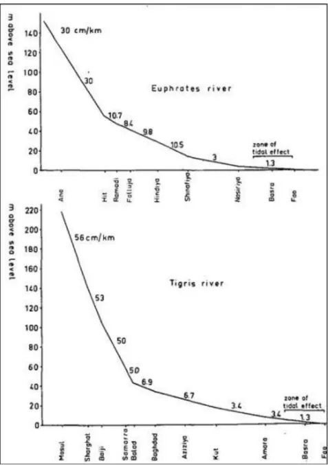
The area of the Tigris and Euphrates rivers basins is 704,500km2 of which 359,000km2 is in Iraq (Buringh, 1960). One of the most common natural phenomena in Mesopotamia over history is flooding. In Mesopotamia, which is relatively flat, lands have mild slopes, while in hilly and mountainous areas the lands are undulating with steeper slopes. Thus, Mesopotamia is the place where flooding effects are felt more, (Sousa, 1963). Figure 1 gives the profiles of both the Tigris and the Euphrates rivers showing changes in their elevations throughout Iraq.
Figure 1: Profiles of the Euphrates and Tigris River showing changes in their elevations within Iraq (Buringh, 1960).
In Iraq, the water year or hydro year, is considered to denote the sequence of all hydrological events in one year. Its beginning is taken as the first of October and continuous till the end of September of the following year. Water levels in the rivers tend to be at their lowest in September and October, which then start rising due to rain storms followed later on by snow melt in the catchment areas. The flood season can be, therefore, separated into two periods; the unstable period which begins in the beginning of October and ends at the end of March. The floods of this period
are caused by rains and their runoff, and they are unstable because of their dependence on rain storms which come suddenly and end when the rain storms end. The second period is more stable, and it begins in March and continuous in April and May. The main floods of this stable period are caused by snow cover melting in the catchment areas. The main floods or spring floods record high levels in the rivers when rain storms are accompanied with the snow melt. The flood of the Euphrates normally starts about two weeks after the flood of the Tigris and ends about one month after that. Whereas, the 15th of May can roughly be considered as the end of the flood in the Tigris River, the flood in Euphrates does not end until after the mid of June. Generally, the flood of Euphrates is gentler in comparison with flood in Tigris, this could be attributed to the comparatively flatter slopes in Euphrates and the longer distance to the mountainous catchment (Sousa, 1963).
2. Floods Over History in Mesopotamia
One of the major concerns of the Mesopotamian kings and emperors was always flood protection and irrigation management. Since early civilizations in the periods of Sumerians, Akkadians, Babylonians, Assyrians, and the Islamic eras, all of them had paid lot of attention and spent much effort to organize and manage water resources in Mesopotamia; flood protection issues being always central among the main works. For instance, during the second Babylonian period of the Chaldeans era, a 50km long dam was built near the recent location of Baghdad, where Euphrates and Tigris are approaching, to store flood waves in the depression of Agarkof and protect downstream lands .The Great Nimrod Dam is said to have been built by the Babylonians on the Tigris near the present city of Tikrit to serve both irrigation and flood protection this dam continued to function 3,000 years until the mid of 10th century. Moreover, during the short stay of Alexander the Great in Babylon (332BC-331BC) he developed the intake of the flood escape channel of the Euphrates upstream from Babylon which was called then the Pallacopas (Al Hindiya Branch of the present Euphrates River). This branch was normally dammed and kept closed in the low water seasons, but had to be opened in high floods to escape the excess waters of the Euphrates to the southern marshes and then immediately close it again, so that after the flood the full discharge would flow in the main stream passing Babylon River (Shatt Al-Hilla now) ensuring the irrigation of Babylon and its enviro. This was the place where Hindiya Barrage had to be built in the early 1910s to share the Euphrates water equitably between the two branches and at the same time ensure proper passage of floods. Further to the north, Nahrawan and Samarra Canals are among many canals that had been used for irrigation and flood waves dissipation. There are no measured discharges recorded in the Euphrates or Tigris until the beginning of 20th century, when the British engineers established gauging station in Baghdad. Therefore, only qualitative descriptions are available for the floods in the past times. Although, during Abbasid era, depths of flow were measured by arm measure, there were no referenced bench mark
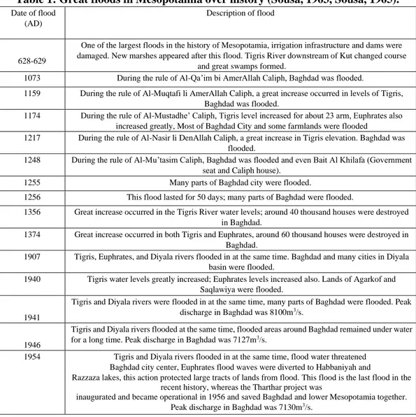
identified. Moreover, it is unfortunate that, some of the data and information were lost in the political upheavals during the rule of some of the regimes in Iraq (Ministry of Irrigation, 1954, Sousa, 1963, Sousa, 1965). The most well-known great floods over history in Mesopotamia are summarized in Table 1 below.
Table 1: Great floods in Mesopotamia over history (Sousa, 1963, Sousa, 1965).
Date of flood (AD)
Description of flood
628-629
One of the largest floods in the history of Mesopotamia, irrigation infrastructure and dams were damaged. New marshes appeared after this flood. Tigris River downstream of Kut changed course
and great swamps formed.
1073 During the rule of Al-Qa’im bi AmerAllah Caliph, Baghdad was flooded.
1159 During the rule of Al-Muqtafi li AmerAllah Caliph, a great increase occurred in levels of Tigris, Baghdad was flooded.
1174 During the rule of Al-Mustadhe’ Caliph, Tigris level increased for about 23 arm, Euphrates also increased greatly, Most of Baghdad City and some farmlands were flooded 1217 During the rule of Al-Nasir li DenAllah Caliph, a great increase in Tigris elevation. Baghdad was
flooded.
1248 During the rule of Al-Mu’tasim Caliph, Baghdad was flooded and even Bait Al Khilafa (Government seat and Caliph house).
1255 Many parts of Baghdad city were flooded.
1256 This flood lasted for 50 days; many parts of Baghdad were flooded.
1356 Great increase occurred in the Tigris River water levels; around 40 thousand houses were destroyed in Baghdad.
1374 Great increase occurred in both Tigris and Euphrates, around 60 thousand houses were destroyed in Baghdad.
1907 Tigris, Euphrates, and Diyala rivers flooded in at the same time. Baghdad and many cities in Diyala basin were flooded.
1940 Tigris water levels greatly increased; Euphrates levels increased also. Lands of Agarkof and Saqlawiya were flooded.
1941
Tigris and Diyala rivers were flooded in at the same time, many parts of Baghdad were flooded. Peak discharge in Baghdad was 8100m3/s.
1946
Tigris and Diyala rivers flooded at the same time, flooded areas around Baghdad remained under water for a long time. Peak discharge in Baghdad was 7127m3/s.
1954 Tigris and Diyala rivers flooded in at the same time, flood water threatened Baghdad city center, Euphrates flood waves were diverted to Habbaniyah and
Razzaza lakes, this action protected large tracts of lands from flood. This flood is the last flood in the recent history, whereas the Tharthar project was
inaugurated and became operational in 1956 and saved Baghdad and lower Mesopotamia together. Peak discharge in Baghdad was 7130m3/s.
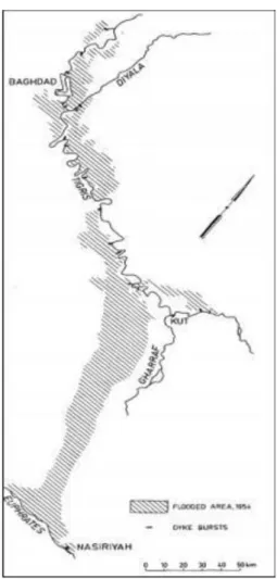
Measures taken to protect Mesopotamia from flooding during the early times were to divert flood waves to natural depressions alongside and close to the river courses. After the establishment of Directorate General of Irrigation in Iraq in 1917, studies were made to utilize both of Tharthar and Habbaniyah depressions for this end. This was suggested earlier by the British engineer Sir William Willcocks, in his study of irrigation works which he had prepared for the Ottoman Government before the First World War. Development of Habbaniyah lake reservoir did not start until the late 1940s, while works in the Tharthar lake reservoir were not complete until 1956 and both projects were accomplished by the Development Board. Similarly, the Shweicha depression and Southern Marshes were developed to absorb and contain flood waves and protect the cities and towns in the lower of Mesopotamia (Ministry of Irrigation, 1954, Willcocks, 1911). The flood of 1954 is therefore the last flood that inundated large areas in Iraq, whereby the completion of flood protection projects and dams has provided efficient control on the large flood waves in 1969 and 1988 (Ministry of Irrigation, 1988). Figure 2 shows the extent of the flooded area in 1954.
Figure 2: Flooded area in 1954 (Buringh, 1960).
3. Habbaniyah Project
Studies and designs for the development of Habbaniyah depression were started by William Willcocks in 1911. This depression is located east and southeast of the city of Ramadi close to the course of the Euphrates River. The construction works on the project began in 1940, but due to the political events of May 1941 in Iraq, works were stooped. The Directorate General of Irrigation, however, and in eight occasions had deliberately breached the flood protection dykes of the Euphrates at (Al Sitaieh), to the west of Khalidiya, in the period from 1924 to 1942 in order to divert the peaks of these floods and pass them to Habbaniyah natural depression (Ministry of Irrigation, 1954). Works are on the project were resumed in the early 1950s, on the recommendation of The Heigh Irrigation Development Commission which had been working on this matter from 1945 till 1948 and submitted its report in 1949. The commission was tasked to re-examine the feasibility of the projects proposed by Sir William Willocks and advice on new ones in the Euphrates and Tigris Rivers in Iraq, and its report became later on the basis of the work of the
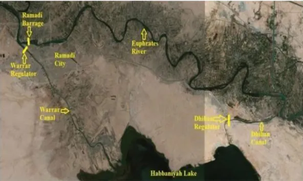
Development Board in this sector (Heigh, 1951). The Development Board had initiated the implementation of this project, which was awarded to British contracting firms. The project was inaugurated on 5/4/1956 (Sousa, 1966). Figure 3 shows an aerial view of Habbaniyah project.
The project consists of the followings: 1. Ramadi Barrage.
2. Warrar regulator and Warrar Canal. 3. Dhiban Regulator and Dhiban Canal. 4. Mijarrah Regulator and Mijarrah Canal. 5. Habbaniyah Lake.
6. Razzaza Lake or named also Abu Dibis depression.
Ramadi Barrage is located on Euphrates River, upstream the city of Ramadi; Water levels are controlled by the Warrar Regulator upstream of the barrage which diverts the excess flow of the Euphrates through Warrar Canal to Habbaniyah Lake. The barrage length is 209m, and it consists of twenty-four bays of dimensions (6×8)m, which are controlled by vertical lift gates. The maximum design discharge is 3600m3/s at level of 51.5m a.s.l. The structure includes a navigational look with
dimensions of (6×40)m and a fish ladder.
Figure 3: An aerial view of Habbaniyah Project showing Ramadi Barrage and other related Structures (modified by the authors).
Water from the lake can be routed back to the Euphrates River by another arrangement, whereby, the lake is connected by an outlet canal of about 9km long which is called the Dhiban Canal. Regulation is accomplished by a cross regulator on this outlet canal which is the Dhiban regulator; it consists of five gated openings with dimensions of (4.7×5)m, and has total maximum discharge of 800m3/s. In addition to this there is at the south-eastern edge of the lake another escape regulator, which is the Mijarrah regulator that diverts the excess water through Mijarrah Canal to Razzaza Lake. Mijarrah regulator consists of eight openings and the maximum discharge of the regulator is 1900m3/s (Al-Simawi, 2014, Ministry of Water Resources, 2005). The level of the bottom of Habbaniyah Lake is 36m a.s.l., while the maximum operation level is 51m a.s.l. These levels make the total storage of the lake 3.28 billion cubic meters of which 2.72 billion is live storage. The surface area of the lake at the maximum storage level is 425km2.
As for the Razzaza Lake, it has only one inlet and no outlet. The excess water in Habbaniyah Lake would be normally diverted to Razzaza. the lake bottom level is 17m a.s.l. and the maximum storage capacity is 25.75 billion cubic meters at level of 40m a.s.l., and it has a surface area of 1,810km2 (Al-Simawi, 2010, Al-Simawi, 2014).
4. The Tharthar Project
The flood event of the year 1954 had accelerated the implementation of Tharthar project, and this flood was the last flood to inundate prats of the city of Baghdad. The German Contractors (Zublin), were awarded the implementation works of the structure, while a British firm (Ransom and Rapier) carried out the manufacture of the hydro-mechanical equipment. The works were started in 1953, and the project was inaugurated on 16th April 1956 when the flood flow was diverted to the Lake in the same month (Al-Simawi, 2010, Sousa, 1966). Figure 4 shows the various parts of both of the Tharthar and Habbaniyah projects.
Tharthar project consists the following: 1. Samarra Barrage.
2. Tharthar regulator and Tharthar Canal. 3. Irwayah Canal.
4. Tharthar outlet regulator. 5. Division regulator.
6. Tharathar-Tigris and Tharathar-Euphrates Canals. 7. Tharthar Lake.
The first structure of the Tharthar project is Samarra Barrage. It is located on the Tigris River at the city of Samarra. The barrage length is 252m and it has seventeen gated openings of dimensions (12×12)m with maximum total discharge of 7,000m3/s at elevation 69m a.s.l. On the left side of the barrage, a hydro-power station was built and commissioned in 1972 which was equipped with 4×21 run of the river Kaplan turbines making an installed capacity of 84MW. On the same side,
the head regulator of the Ishaqi Main Canal is incorporated which four has gated openings leading to the canal itself through four concrete box culverts with dimensions of 2.5×2.5m. A Spiral tube silt exclusion arrangement is also provided to remove the silt and stop it from entering the canal. In addition, there is a fish ladder in the barrage to facilitate the migration of fish to the upstream.
Figure 4: Tharthar and Habbaniyah projects.
(Ministry of Water Resources, 2005).
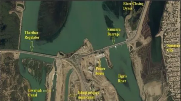
The next structure in this complex scheme is the Tharthar Regulator which is located at the right side of Samarra Barrage. The regulator controls the passage of flood waves of the Tigris River to Tharthar Lake with maximum discharge of 9,000m3/s at elevation 69m a.s.l. It has thirty-six openings with dimensions of (7×12)m passing the water to the Tharthar flood escape canal, which in turn conveys it to Tharthar Lake. The canal has a total length of 65km. In 1991, two gated bays on the left side of the regulator were isolated in order to feed the Irwaiyiah Canal. This canal which has a capacity of 250m3/s was designed and constructed for the irrigation of a tract of agricultural land to the left of the Tharthar Lake. The canal finally ends in the km 26.8 of the Tharthar-Euphrates Canal, which is to be described later on. The length of the Irwaiyiah Canal is about 97 km. In Figure 5 satellite view is presented of Samarra Barrage and Tharthar Regulator (Al-Simawi, 2014, Ministry of Water Resources, 2005).
Figure 5: Satellite view of Samarra Barrage and Tharthar Regulator (Abdullah, Al-Ansari and Laue, 2019).
At the early stages of operation of the Tharthar scheme, studies did not favour using the storage water for irrigation due to its high content of sulphate salts. Later on, other studies showed that the salinity problem may decrease with the passage of time by the recurrent floods which bring good quality water into the lake. Moreover, it was contemplated that this water can be used for irrigation after mixing with Tigris and Euphrates waters. The decision was finally taken to excavate canals connecting Tharthar Lake with the Tigris and Euphrates rivers to withdraw water to the two rivers. The operation of these canals was conditioned by mixing predetermined quantities of water from the lake with the rivers’ discharges available in the rivers
at the time to keep the salinity of the water within the acceptable limits. This was misused, however, in many occasions during shortage periods in the rivers
which led to increase the salinity in the downstream reaches. The construction works of the Tharthar Outlet Head Regulated were started in 1972
at the southern edge of the lake and it was inaugurated in 1976. The Outlet Head Regulator has six openings with dimensions of (6×8)m and its maximum discharge is 1100m3/s. The level of the sill was chosen at elevation 40m a.s.l., making the dead storage of the lake (Al-Simawi, 2014, Rafidain, 1989, Sousa, 1966). The Main Tharthar- Euphrates outlet canal, mentioned already, starts from the Tharthar Outlet Head Regulator and extends in a straight line for 26.8km until it comes to the Divide Structure which splits the discharge between two branches namely the Euphrates Arm Canal, and the Tigris Arm Canal.
The Divide Structure is formed of two regulators; the first is a cross regulator on the main stream and the second is head regulator located on the left side. This head regulator has four gates with dimensions of (8×7)m and a discharge of 600m3/s, it passes its discharge into the Tigris Arm canal which continues eastwards for 28.5km until it reaches a drop structure which functions as control for the water elevation, it has four openings with dimensions of (8×12.85)m. This canal continues until 36.5km to flow in the Tigris River at Taji north of Baghdad. Water was diverted
through this canal for the first time in 1988. Now coming back to the cross regulator, it is provided with four gated openings
with dimensions of (8×7)m and can pass a discharge of 500m3/s. This structure marks the starting point of the Euphrates Arm Canal which runs down in south-westerly direction to empty in the Euphrates River upstream of Fallujah Barrage near Habbaniyah city. The length of Euphrates Arm Canal is 9.5km and. Water was first diverted through this canal to Euphrates River in 1976 (Al-Simawi, 2014, Rafidain, 1989). Tharthar Lake is one of the largest natural depressions in the region, where it's located west of Samarra, the lake has a pear shape with a maximum length of 120km and a maximum width of 45km. This depression is a natural feature believed to be caused due to karstification and continuous sinking of a subsurface graben. The bottom elevation of the lake is 3m below sea level and the maximum elevation is 65m a.s.l. (Sissakian, 2011, Sousa, 1966). The depression is fed by surface runoff through Wadi Al- Tharthar which starts from Sinjar Mountain at the northwest and drains the foothills of this range. Tharthar Lake maximum capacity is 82 billion cubic meters at elevation 65m a.s.l. Flood water has been diverted to the lake for many years but the rate of income has been decreasing since the operation of Mosul Dam on the Tigris River in the north and it is expected to decrease further if the planned Bekhme and Makhoul Dams are constructed . One of the main issues on Tharthar Lake is the large evaporation losses estimated to be 7.4 billion cubic meters per year at maximum capacity of the lake, due to its large surface area of 2700km2 at its maximum operation level of 65m a.s.l., and 1600km2 at the Tharthar outlet Regulator sill level of which is 40m a.s.l. This high rate of evaporation is intensifying the salinity problem of the lake’s water which originates
basically from the geological formations at the bed and sides. Moreover, the proximity of the mouth of the lake to the Outlet Head regulator does not allow proper mixing of the incoming flood water with the whole body of the reservoir which is reflected negatively on the mixing and the homogeneity of salt concentrations in the lake (Al-Ta'i, 2015, Rafidain, 1989).
5. Shweicha Depression
Many seasonal Wadies originates in the western part of Iran and enter Iraq across the borders between the two countries in the stretch extending from Naftkhanah in Diyala Governorate to Badra in Wasit Governorate, in addition to other such rivers and Wadis in the southern sector of the border within Maysan Governorate. The wadis, within the Diyala and Wasit Sectors drain in the Shweicha Depression. Counting them from north downwards they are, Wadi Al- Naft which enter Iraq near Naft- khana, Wadi Haran, also called locally Galal Gangir and enters Iraq in Mandali, Wadi Hizam, Wadi Talha, Gala Tursaq, Wadi Shorshoren and Kunjancham River or Galal Badra. The Shweicha depression itself stretches to the east and northeast of Kut city and it acts as the collector of the runoff of these wadies. The highest discharge that can originate from these Wadis during rain storms is that of Galal Badra where it may reach 3,500m3/s (Saeed, 2018). The development of this depression was mentioned in the recommendations concerning the irrigation projects presented by the British Engineer Sir Willcocks and the subsequent British Consultants. The first proposal was to divert part of the floods of the Diyala River to this depression, in addition to flows from the eastern Wadis originating in the highlands of the Iranian side. This proposal was not implemented, but the depression continued to store water coming from the mentioned wadies, and discharge facilities to return the water to Tigris river were constructed, i.e. through Um Al-Jerie Regulator which has a capacity to discharge 25m3/s, in addition to the, Nishama Escape with discharge capacity of 50m3/s. The reservoir is important to supply irrigation requirements downstream Kut Barrage as well as improving navigation also (Saeed, 2018, Sousa, 1947). The eastern Wadis are intermittent streams, their floods are always caused by rainstorms, and due to the appreciable difference in elevation between their catchment area in Iran and the Shweicha depression the filling of the depression tends to be rapid. The shallow depths and the vast surface area of the Shweicha tend to cause the loss of most of the storage by evaporation during summer. Figures 6 and 7 show the rapid filling of the depression from the Easter Border Wadis and emptying the Shweicha.
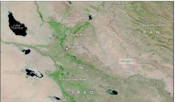
Figure 6: Upper part of Mesopotamia on 12 October 2015(NASA, 2020).
Figure 7: Upper part of Mesopotamia on 11 November 2015(NASA, 2020).
6. Southern Marshes
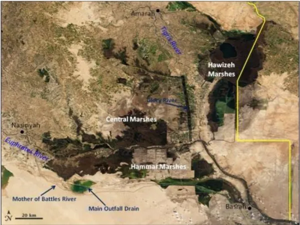
The Marsh area in southern Mesopotamia has been formed and sustained over the ages by always collecting the floods of The Tigris and Euphrates at lower Mesopotamia. This is being the case due to the mild slopes of the two rivers in this part and the limited capacity of their channels. The flood water overtopping the river banks is finally collected and absorbed by these Marshes. Figure 8 shows a satellite view of southern marshes.
Figure 8: Satellite view of Southern Marshes (Wikipedia, 2020).
There are three major marsh areas in lower Mesopotamia which contain large and small interconnected marshes, which may be detailed as in the following; first, is Hawizeya Marsh, which is the largest among all the other marshes. It is located in the province of Maysan on the left side of the Tigris River. This marsh is shared between Iraq and Iran and the border line passes through it. The major feeder of Hawizeya, in addition to the tails of irrigation channels in Maysan Governorate, is Karkheh River, which originates and flows in Iran. Hawizeya Marsh area varies between (2500-1250)km2 within Iraq and Iran. The marsh is is connected to the Tigris River and Shatt Al-Arab by canals which are controlled by regulators, these regulators are:
1. 1.Kassara/Hawizeya regulator: water from the Marsh is discharged by this regulator to the Tigris River at this point which is close the Ezir town. It has
three openings with dimensions of (2×2)m, and it is provided by side spillway 65 m long. The regulator discharge is 120m3/s.
2. Swaib regulator: This regulator is located on Shatt Al- Arab near the town of Qurma. It discharges the water to Shatt Al- Arab at a capacity of 200m3/s. It consists of four openings with dimensions of (2×2)m, and a side spillway 140m long.
3. Kumait escape, which is located upstream of Amara City. The escape is controlled by a regulator constructed in the 1990s on the left side of Tigris River openings five kilometres upstream of Kumait city. The Regulator has t27 with a width of 3.5m each and a discharge of 400m3/s. The Regulator discharges the water to Sannaf marsh, which is connected with Hawizeh Marshes.
Second, the Central Marshes, also called Qurna Marshes. These are located within Maysan, Basra and Dhi-Qar Governorates, between the Euphrates and Tigris Rivers. The Central marshes are fed by flood water from Tigris River at its right side. The surface area of the Central marshes varies between (2350) and (2500)km2.
Two important arrangements help to divert Tigris floods to the Central Marches; the first is the Musandag flood escape channel and the second is an escape route starting about 15km upstream of Amarah city. The flow into this route is controlled by two regulators; namely the Buteirya and Eraidh which have a combined capacity of 700m3/s. The capacity of the escape itself, however, is much less. During high floods, the Central Marshes overflow into the Euphrates River which borders it from the south and join with the Hammar Marsh. The Central Marshes normally drain through several openings to Euphrates River, one of the most important of them is the outlet of Ezz River. Finally, the Hammar marsh located on the left side of the Euphrates River. The River connects with the marsh by several branches downstream of the town of Suq Al-Shuyukh. The surface area of this marsh varies between (1650-595)km2 (AlSimawi, 2014, Hassan, 2006, Ministry of Irrigation, 1988).
7. Conclusion
Several lessons can be drawn from the floods and flood protection infrastructure in Iraq, of which are:
1. Flood is a normal phenomenon in Mesopotamia which is controlled by the hydrology of the two rivers, Tigris and the Euphrates
2. Habbaniyah and Tharthar lakes are successful flood protection projects, which with the help of the upstream dams on the rivers and their tributaries, offer almost complete protection from floods for the whole area of Mesopotamia, they are protecting the land of Iraq snice the mid of 1950s. 3. Iraq need just to maintain and properly operate the existing flood protection
infrastructure, which had protected the lands for more than 6 decades. 4. It is important also to build regulators at locations were breaches in the flood
protection dykes often occur in order to have proper control; one such regulator can be useful on the head of the Musandag escape channel. Some barrages may be needed also to make flood diversion easier. A complete evaluation of the whole system is advisable, and any discovered deficiency must be addressed in the future plans.
References
[1] Abdullah, M., Al-Ansari, N. and Laue, J. (2019). Water Resources Projects in Iraq: Reservoirs in The Natural Depressions. Journal of Earth Sciences and Geotechnical Engineering, Vol.9, Issue 4, pp. 137-152.
[2] Al-Simawi, H. (2010). Irrigation and Drainage Projects in Iraq. Library of the Ministry of Water Resources, Baghdad, Iraq.
[3] Al-Simawi, H. (2014). Irrigation Regulators in Iraq until the end of the year 2013. Library of the Ministry of Water Resources, Baghdad, Iraq.
[4] Al-Ta'I, M. (2015). Effect of Influent Point of Atharthar Lake on the Distribution of Water Quality. MSc thesis (unpublished), University of Baghdad, Baghdad, Iraq.
[5] Buringh, P. (1960). Soils and Soil Conditions in Iraq. Ministry of Agriculture Baghdad, Iraq.
[6] Esri (2020). ArcGIS Online. Retrieved on 1/1/2020. https://www.arcgis.com/index.html
[7] Hassan, K.H. (2006). Geographical Analysis of Drained Marshes in Southern Iraq. Dhi-Qar University Journal, 2, 3, 1-8.
[8] Heigh, C. (1951). The Control of the Rivers of Iraq and the Utilization of Their Waters. Library of the Directorate General of Irrigation, Ministry of Irrigation, Baghdad, Iraq.
[9] Ministry of Irrigation (1954). Report about Directorate General of Irrigation Works for a Five Years from 1949 to 1954. Library of the Directorate General of Irrigation, Ministry of Irrigation, Baghdad, Iraq.
[10] Ministry of Irrigation (1988). A Report of the Year 1988 Flood. Library of the Ministry of Irrigation, Baghdad, Iraq.
[11] NASA (2020). Earth Observatory Webpage. Retrieved on 1/1/2020. https://earthobservatory.nasa.gov/
[12] Rafidain Co (1989). Flood Wave of Tharthar-Euphrates Main Regulator. Library of the Ministry of Irrigation, Baghdad, Iraq.
[13] Ministry of Water Resources (2005). The Encyclopedia of Irrigation in Iraq, February 1918-February 2005. Library of the Ministry of Water Resources, Baghdad, Iraq.
[14] Saeed, F.H. (2018). Optimum Utilization of Iraqi Eastern Streams. Proceedings of the water scarcity in Iraq, current situation and future challenges, 16-17 August, Istanbul, Turkey.
[15] Sissakian, V. (2011). Genesis and Age Estimation of the Tharthar Depression, Central West Iraq. Iraqi Bulletin of Geology and Mining, 7, 47-62.
[16] Sousa, A. (1947). Major Irrigation Projects: The Reservoir of Shweicha Marsh. AlMa'aref Press, Baghdad, Iraq.
[17] Sousa, A. (1963). Baghdad Floods in the History: Volume 1, Al-Adeeb Press Baghdad, Iraq.
[18] Sousa, A. (1965). Baghdad Floods in the History: Volume 2, Al-Adeeb Press Baghdad, Iraq.
[19] Sousa, A. (1966). Baghdad Floods in the History: Volume 3, Al-Adeeb Press Baghdad, Iraq.
[20] Wikipedia (2020). Mesopotamian Marshes. Retrieved on 1/1/2020. https://en.wikipedia.org/wiki/Mesopotamian_Marshes
[21] Willcocks, W. (1911). Irrigation of Mesopotamia, Spon & Chamberlain, London.