NATURGEOGRAFISKA
INSTITUTIONEN
AVDELNINGEN FOR NATURGEOGRAFI
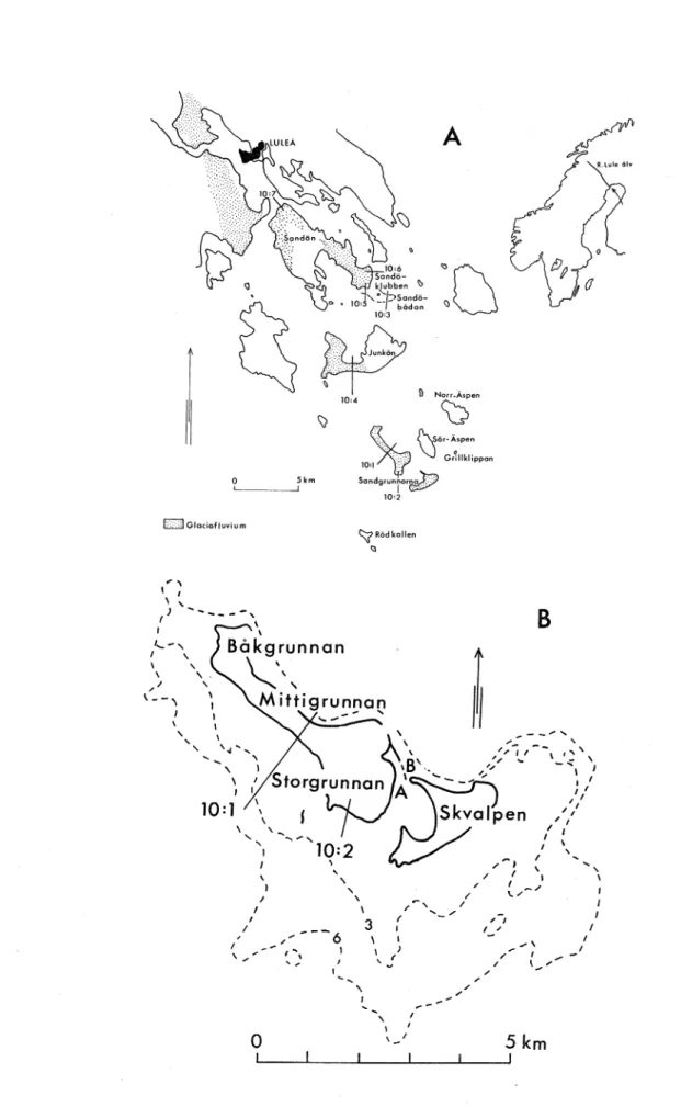
SANDGRUNNORNA IN LULE ARCHIPELAGO
-
RECENT TRANSFORMATION OF A GLACIOFLUVIAL
DEPOSIT IN AN
ENVIRONMENT
OF LAND UPLIFT
GORAN ALBJAR
LICENTIATAVHANDLING
I NATURGEOGRAFI
DEPOSIT IN AN ENVIRONMENT OF LAND UPLIFT
GORAN ALBJAR
LICENTIATAVHANDLING
I NATURGEOGRAFI
1985-05-06
.'\,:.
\ Goran Albjar
Department of Physical Geography, Uppsala University
ABSTRACT
In an area of rapid land uplift the geomorphological evolution of the glaciofluvial island of Sandgrunnorna, 25 km SE Lulea, in the Bothnian Bay, is discussed from old maps, air photographs and field studies. The island were marked on a map for the first time in 1790, but the high-est parts can be high-estimated to have reached the sea surface about 100 years earlier. The areal growth has been reconstructed by map and air-photograph studies. A model of the geomorphological evolution based on the interaction between bottom morphology, land uplift and waves is presented.
INTRODUCTION
A considerable part of the Swedish landscape has been formed primarily by deposits from the melting phase of the last glaciation. However, large areas of this landscape have been re-formed by coastal processes, since these areas were situated below the sea level during the deglaciation phase. Approximately one third of the present Swedish land area has, at some time during or after the retreat of the inland ice, been below sea level. As the shore displacement, the rate of which depends on the interplay between isostatic and eustatic processes, has progressed, the shore processes have re-worked different levels of the glacial deposits.
The largest postglacial shore displacement in Sweden is found in the mid-latitude regions of the country, where old shorelines are found at levels of approximately 285 m above present sea level. Whereas in the northern Gulf of Bothnia, old shorelines have been formed at levels
of up to approximately 200 m a s 1, the highest shoreline on the
south-ern coast of Sweden is found at just a few ma s 1. The highest shore
displ-acement rate at present, approximately 9 mm per year, occurs on the coast of the Gulf of Bothnia. The regression decreases to the south and changes on the southern coast of Sweden to a faint transgression. The morphology of the previously transgressed areas is primarily de.ter-mined by coastal processes. Erosion and/or accumulation processes have, depending on the existing type of environment, transformed the origin-ally marine sediments. In Sweden, the dominant type of soil deposit is till but beaches formed in glaciofluvial and fluvial sediments also occur frequently.
Large glaciofluvial deposits, often found within present river valleys, were formed marginally or submarginally at the front of the ice sheet during periods when the ice river debouched in approximately the same place for a long time, but also as deltaic deposits at the highest shore-line.
A considerable number of studies have previously been carried out on the distributions of beaches in shore displacement environments. Several good descriptions of wave washed till and re-worked glacio-f luvial deposits have also been made. However, speciglacio-fic studies oglacio-f the processes responsible for shore formation in a shore displace-ment environdisplace-ment are lacking. Brydsten (in press) investigates the
shore processes in environments of till deposits.
Sandgrunnorna, an island in the Lule archipelago in the Gulf of Bothnia, exemplifies recent geomorphological evolution of an island in an area of rapid land uplift. The aim of this study is to produce results that will facilitate interpretation of similar, elderly for-mations in environments of shore uplift. Furthermore, the model should be useful in archaeological investigations, since habitations, burial grounds, etc, often are found near large glaciofluvial deposits, which tend to be located at levels where the shoreline has been stable for some time or has advanced upwards temporarily (Lundkvist 1982).
Sandgrunnorna originally consisted of a couple of small isles. Today, however, it forms , within normal water levels at least, one island. Sometimes during storms, however, the tombola connecting the two main parts of the island becomes submerged. The island is the outermost exposed part of the glaciofluvial trail that can be traced along the lower section of the Lule Alv river valley and via a number of islands out, below the sea, into the Gulf of Bothnia (Fig 1).
The total length of the island is at present 6.5 km and its maximal width is 2 km. The island is formed exclusively in glaciofluvial material of all sizes, but sand is predominant. The flat, low island is characterized by dune ridges of various ages and by deflation surfaces. The vegeta-tion is sparse; the present beach dunes are covered by scattered tufts
of lyme grass (Emylus arenarius ) and the older, inner-island dunes
have a thin cover of various grasses and herbs. The deflation surfaces often lack vegetation or there are scattered stands of a few species of herbs, mosses and lichens. The tree and bush vegetation - which
princip-ally consists of pine (Pinus), rowan (Sorbus), alder (Alnus), birch
(Betula), willow (Salix), and juniper (Juniperus) - is also sparse. Enequist (1944) studied the evolution of coastal dunes on some islands in the Lule archipelago. She traced the evolution of Sandgrunnorna, using maps from the period 1790 - when the islands were first marked on a map - to 1942 - at which time Enequist herself made vegetation and geomorphological maps of parts of the islands. In an earlier study, Bygden (1910) investigated the shore displacement at Pitea, 50 km SW of Lule archipelago from old maps. More recently, Nordebo (1956) studied the shore displacement at Nederkalix and Nedertornea, ea 50 km NE Lule archipelago from i a old maps. Jarnefors (1949) de-scribed the effects of swash action on the shores of the Gulf of Bothnia. Grano (1981) studied the evolution of an esker in the en-vironment of shore displacement of southern Finland.
Material collected by my own field work and references found by library research and partially unpublished material and descriptions made by Enequist (1944) have been used for this paper.
Fig 1a Fig lb 0 5km L--~---1 CJGlaciofiuvium
..
'
I I \ ... (} ---''
' ...'
\ l \ I I I 10:1 \ I / I I I I \ ,,..
0
A
:···.;·.·.· Sando-:·.··; klubben ~ . ., .... _.;.. .. 10,6.,()U
' \ 10 . o,foknppan Sondgrun.ror~ 10'2 "'\? ROdkollen"'
'
'
I \ I 3 / I I I I ) ' ( / ' ... _,, / ... .... ....-'
I I ,_, /B
\ I I ' -" I'-"
... '_,
/ I ,,.. / \ ... / 5km ...'
I ( I I I IMap of the Lule archipelago in the northern Gulf of Bothnia, showing the glaciofluvial deposits and profile locations. Map of Sandgrunnorna, showing profile lines (Fig 10) and loca-tions of box core sample A (Fig 14) and tube core sample B
CONDITIONS FOR ISLAND FORMATION
G e n e r a 1 r e m a r k s
Island and beach formation and the evolution of these and nearshore areas are determined principially by wind-generated waves. Consequent-ly wind direction, frequency and duration, as well as the distribution of fetches are of prime importance. Other significant elements are bed-rock morphology, soil deposits, bottom topography, long and short range variation of water levels and ice conditions.
The most important condition for island forriation in a shore displace-ment environdisplace-ment - as in other environdisplace-ments - is the supply of suitable material. A sediment consisting of material finer than sand is often too readily suspended to allow for beach formation and will be trans-ported offshore and deposited in deeper water. Even a pure-sand material will unlikely form islands, unless the wave action is decidedly moderate
or the sand supply very a~undant. At normal wave action, a core of
coarse, hard-to-transport material of boulders and stones are necessary to produce an environment of wave lee. By means of wave refraction, the sand is transported to the lee side of the skerries, where it is accu-mulated. Once the island formation has started, the sand accumulation is accelerated due to the steadily expanding calm-water area. Without a solid core, island formation is rare, even when a rich supply of sand is available. An example of this condition, albeit in some different environment, is Vastra Haken, off Skanor in southernmost Sweden. At this location, a large, sandy area of shallow water is continuously expanding, at times very rapidly, by heavy sediment transport. In this location, however, the level of the shallows is balanced at the water-line by wave action.
C o n d i t i o n s i n t h e L u 1 e a r c h i p e 1 a g o
The dominant wind directions in the Lule archipelago are, first, S-SW and, second, N-NE (H:son Ager 1964). In addision to land uplift,
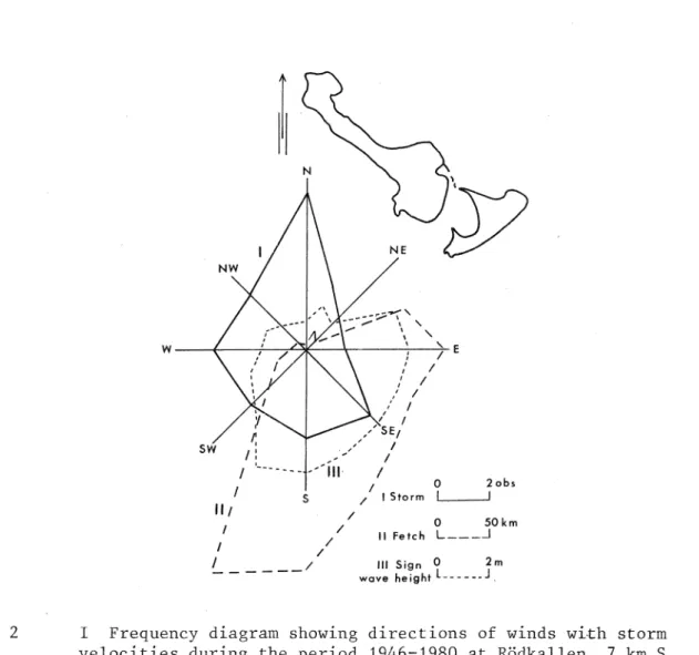
storm waves have the greatest effect on the evolution of the island. A study of storm winds, measured at the Rodkallen island, 7 km S Sand-grunnorna, during the period 1946 to 1980, and based on statistics from the Swedish Meteorological and Hydrological Yearbooks, shows that
during the ice free period of the year (May-Dec), most storms tend to be rather uniformly distributed but with some dominance from N and less from E (Fig 2). However, the wave action from the section W to NE is heavily reduced by the presence of the archipelago and the short distance to land, and therefore the dominant wave action comes from the section SSW to SE (Fig 2). The fetches from the SSW, S, and SE are 225 km, 200 km, and 100 km, respectively, and the waters are' almost completely free from islands. ?ully developed sea from these directions can reach maximum heights of 4.8 m, 4.6m and 4 m, respectively (calculated from D S Army Coastal Engineering Research Center, 1977, Fir, 3-15) (Fig 2). The submarine topography around Sandgrunnorna is primarily a result of conditions prevalent at the time when the glaciofluvium was de-posited; since then, however, the topography has been transformed by wave action as the island has been lifted above the sea. Fromm (1965) considers the glaciofluvi.al deposits in the Lule archipelago to be a
Fig 2 w NW SW J ) E ,' I ,' I , I / I / I , / SEt f, ,' I
I:
-/
I I '--- /Jll I 0 2 obs I S 11 I Storm 11 t 1 0 50km I / I / / II Fetch L ___ _j I---
/ Ill Sign 0 2m wave height L ______ jI Frequency diagram showing directions of winds with storm
velocities during the period 1946-1980 at Rodkallen, 7 km S
Sandgrunnorna.
I I Diagram showing the fetch for different directions from
Sandgrunnorna.
III Diagram showing the calculated significant wave height for
storm winds for different directions at Sandgrunnorna.
marginal or submarginal, subaquatic deposit according to De Geer's esker model. As the esker tunnel has debouched in approximately the same place for a long time, large quantitites of glaciofluvium have been deposited within a limited area. The outflow of the glaciofluvium has probably been limited to the NE by contact with the ice; as a result, this side was steep primarily. To the south, by contrast, exposure to the open sea has caused the glaciofluvium to be spread over a large area. Consequently, the glaciofluvial deposits have produced a gently sloping, lobe-shaped morphology in this direction
DESCRIPTION OF SANDGRUNNORNA G e o m o r p h o 1 o g y
Originally, Sandgrunnorna consisted of a number of small isles which became connected as they grew in size. The first connection between the isles generally occurred through spit growth. In the early 1980'~
Skvalpen, the last sizeable isle to remain separate, was connected to the main island through a narrow spit.
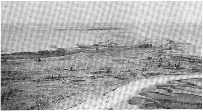
The island's main characteristics is its pronounced flatness (Fig 3). In the interior of the island deflation surfaces occure.
Around these fields, dunes with more or less stabilized vegetation are found. Along the beaches, however, active dune forms, to a
vary-ing extent covered with Emylus arenarius, are predominant.
Coarser fractions, often forming beach ridges, are most frequently found on Bakgrunnan, but occasionally also on Storgrunnan. Along the north and northwest flanks of Bakgrunnan cobble beaches are also found.
In connection to these beaches, especially on the northwest point, boulder fields and beach ridges occur. The most marked form,
consist-ing of boulders, stones and gravels, extends in a southeasterly direc-tion across the flat area called Bakdynslatten which forms the south-east part of Bakgrunnan. This formation may have derived from the point which juts out from the southernmost part of the Ba_kgrunnan island on the
1826 map (Fig 7). An approximately 1-kilometre-long glaciofluvial boulder and cobble deposit, partly transformed by beach ridge forma-tion, extends along the west side.
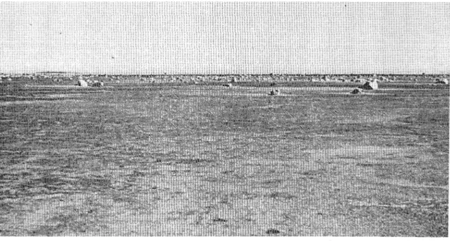
In the inner parts of Bakgrunnan and Sandgrunnan and across Mitti-sandgrunnan, large deflation fields have developed at a few metres elevation above sea level. By eolian processes, sometimes preceded by a certain degree of wave outwash, the sand has been eroded until a top layer of gravel and small pebbles has settled out (Fig
4).
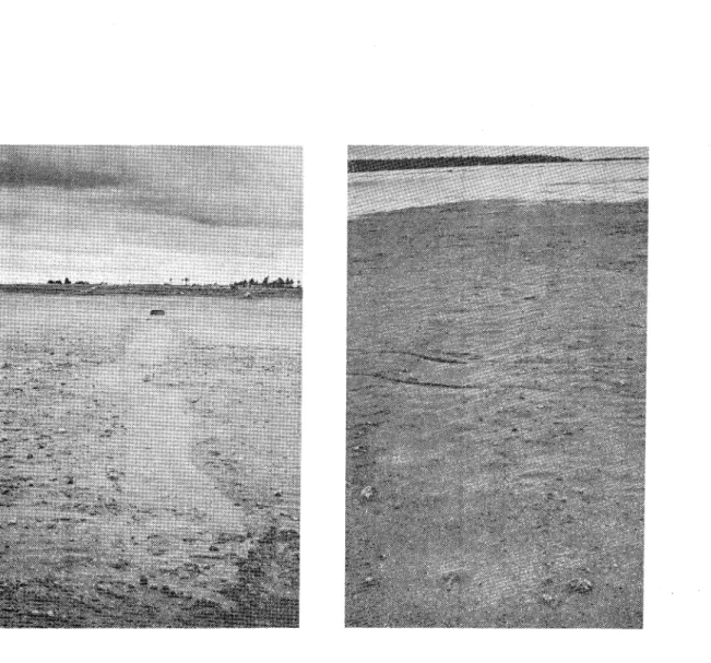
Fig 3 View looking SE of Sandgrunnorna. Observe the still very open higher vegetation of the flat island.
Fig 4 In large parts of the island the sand has been wind eroded until a cover of gravel and pebbles has been concentrated as a protection against further erosion.
The visible parts of Skvalpen consist of sand, but probably these isles, as the rest of Sandgrunnan, also have a core of coarser
material. Inside the approximately 10 m wide beach, a belt of 3-4 m
high dunes has grown up. Behind the dunes extends a large, recently drained sand plain, the surface of which largely consists of gravel and pebbles. Between Storgrunnan and Skvalpen is a lagoon of a few decimetres' depth; its sandy bottom is partly covered by detritus. Along the northeast side of the shoal runs a long tombola, which has recently connected Skvalpen and Storgrunnan. A remarkable number
of large boulders (approximately 0.5-1 m in diameter) is scattered
throughout the lagoon, across the recently drained flat beaches between Storgrunnan and Skvalpen to the south and on the shallow
bottom area south of these (Fig 5).
Fig 5 On the flat, presently drained beaches and in the shallows
between Storgrunnan and Skvalpen are a great number of large boulders deposited.
Similar boulder fields are found on the flat beaches and in the shallow waters off Sandoklubben and the southwestern part of the Junkon Island. The reasons for the prevalence of these boulders and their distribution pattern - roughly at the level of the present shore line - are not yet fully understood. Certainly, large boulders are found at higher levels in the archipelago but not in such large numbers. A possible explanation is that the boulders have been dropped from icebergs stranded in the area during the most recent deglaciation. However, a more feasible ex-planation is that more recent sea ice has picked up the boulders from adjacent till shores and by ice-drift transported them to the locations
in question, where they have stranded. The latter theory is confirmed by the more than 100-m-long drag trails that can be traced from the shoreline across the flat beach on the northwest side of Storgrunnan and up to the boulders (Fig 6).
Fig 6 Ice pressed boulder at the flat north-east side of Storgrunnan.
The sandy shores along the NE side of Sandgrunnorna are generally narrow and relatively steep, sometimes with gravel and stone features. Some stretches might be characterized as erosion beaches. On this side of the island, the bottom is marked by a shallow, approximately
100 metre wide sand shelf, which at a depth of 1 m dips abruptly -at an angle near the angle of repose to a depth of 20 m, where it flattens out again. Close to the shore the sand bottom is often cover-ed by a thin bcover-ed of gravel or stones.
The beaches along the southwestern shore of Sandgrunnorna are generally much wider than those on the northwestern shore and might be classified as accumulation beaches.
In some sections of these bottom areas, stone and boulder features occur. The bottom areas off this side are, as mentioned above, shallow. At a distance of approximately 1 km seaward from the island the water depth is merely 3 m; 2 km offshore it is approximately 5 m. Off this side of the island, as off Skvalpen, a sprawling and complex system of bars has developed. Close to the shore ea 3-decimetre--heigh, and up to a hundred metres long migrating bars with wavelength of ea 10 m, are found. Under advantageous circumstances these bars, after having connected the shore or being deposited at some distance from the shoreline, will be overrun by other migrating bars. Often the next storm will erode such bars but occasionally they may survive to form an important part of the island formation process (Figs 16, 17). Farther out, at depths of about 1-2 m, longshore relatively stationary multiple bars are found. They can be observed on the aerial photographs as long white bands (Fig 8). They have a wavelength of 50 m or more and an amplitude of 0.5-1 m.
V e g e t a t i o n
The vegetation of Sandgrunnorna may be categorized roughly as belonging to one of three distinct types of environments: areas with active beach dunes, areas with stabilized dunes and deflation areas. The active beach dunes which repeatedly become buried under blown sand, generally
have a sparse cover of lyme grass (Emylus arenarius) interspersed
with clumps of Honckenya peploides and Lathyrus maritimus. On the older
dunes, characterized by stabilized vegetation, the Elymus arenarius cover
is thinner. In this environment, herbs and grasses such as Festuca ruba,
Festuca ovina, Deschampsia fle.ruosa, Deschampsia flexuosa, Antennaria dioica, Rumex longifol1:us and Stallaria grmm'.nea dominate. To a great extent the deflation areas are almost completely depleted of
vege-tation. Only a few scattered specimen of Elyrrrus arenarius or Honckenya
occur here. Elsewhere, Glaux maritima and Silene maritima can be found
and - in drier locations - small stands of Empet1°um nigrum. Lichens
and mosses also occur, but they rarely cover areas of any significant size. The island is not wooded; however, Storgrunnan has a row of alders (Alnus), forming a couple of hundred metres long screen. Higher
vege-tation of other kinds include scattered specimen of pine (P1'.nus),
rowan (Serbus), willow bushes (Sal?'.x), juniper bushes (Juniperus), and
birch (Betula). The vegetation on Skvalpen is much less varied than on
the main island. Beside Elymur; arenar-ius on the active dunes, other
pioneer plants such as Honckenya peploides and Lathyrus maritimus are
T h e h i s t o r i c a 1 r e c o r d 0 f S a n d
-g r u n n o r n a
To calculate exactly the point in time when parts of Sandgrunnorna
first rose above the sea~s surface is impossible. The first part of
the submarine esker to reach the water surf ace was not the top of the primary glaciofluvial deposit, since the sand-and-gravel fractions were eroded as the deposit was lifted toward the sea surface. Not until a sufficiently large portion of the coarser material had been washed out of the esker was the real beach formation able to begin.
At a land uplift rate of approximately 90 cm per century (RAK 1971),
the highest boulder ridge on the island - it reaches 3.5 m a s 1
-would, judging from its present height only, have risen above sea level toward the end of the 16th century. It may be assumed, however, that erosive wave action at some point in time lowered the deposit as
it approached the water surface. On the other hand, an approximately
0.5-1 m high stony beach ridge was built up on the boulder areas, as it approached the sea surface. Ice pressure may furthermore have in-creased the height of the ridge. Thus, from the discussion it follows that the true island formation may be calculated to have started not earlier than in the middle to late 17th century.
The record of the evolution of the island has been compiled from older maps and aerial photographs (Fig 7). The oldest map on which Sandgrunnorna
is marked is "Generalkarta till Sveriges sjoatlas", 1790, part 2, by
J Nordenankar. W of Sor-Aspen, three small islands are drawn at the present
location of Bakgrunnan. SSE of these, three marks indicate the pre-sence of skerries; two of these are at the approximate location of present-day Storgrunnan and one is at present site of Skvalpen. Further-more, two hypsographs show a relatively close correlation to the present extension of Sandgrunnorna.
Sandgrunnorna do not appear on the two earlier extant maps of Lule archipelago - "Geografisk Macculatur upp i Tornea, Kalix, Ranea och Lulea Socknars Skargard uti Westerbottens Norra Contract ar 1721" by H Kruse, and "Karta ofer segelleden till Lulea Stad 1764", by Fr Bodin. The absence of any island on these maps does not, however, rule out the possibility that its highest parts had risen above sea level by this time. The first map is very sketchy; e g the rock outcrop called Grillklippan is not marked although it is known conclusively to have risen above sea level by this time. The second map was revised in 1799, nine years after Nordenankar's map on which Sandgrunnorna is recorded, but Sandgrunnorna is still not marked on it. The three small islands drawn SW of Sor-Aspen on Nordenankar's map, roughly represent the actual location of Sandgrunnorna at the end of the 18th century. The location of the islands corresponds to the sites of the boulder and stone ridge formations found on the island today. All formations are
on an altitude of more than 2 ma s 1. The highest of these formations
is the ridge on Lilla Bakdynslatten, which measures 3.5 m a s 1.
The first detailed survey of the islands was made in 1826 in associa-tion with the printing of a new navigaassocia-tion chart. In the 40 years since Nordenankar's map was drawn, the surface area of the islands had evidently increased by approximately 1 km2. Bakgrunnan was still divided into a couple of islands; Mittigrunnan consisted of one larger and some smaller islands. Remarkably, Storgrunnan was already at this time practically of the same size as in 1946.
1790 1826 1842
~
~
f;).f
1868+/
1873 1956'\
I Fig 7 0 2km 1880 1903 1946.
.
t
t
..~
'
It
~
1966..
1973 <l\
1980Compilation of the record of Sandgrunnorna from maps and vertical air photographs between 1790, when the parts of the island first were marked on a sea chart, and 1980 when the last photographs were taken.
In 1842 a transport map covering "Nederlule.& Socken" by E Hallstrom was produced, apparently using data from a new survey. According to this map the land gain was slight in the 16 years between 1816 and 1842. The failure of Mittigrunnan to appear on the map is probably simply a production error.
The first "Ekonomisk karta" of the area was published in 1868; this map is clearly based on a new survey. However, apart from the appear-ance of Mittigrunnan and the addition of some smaller new islands SE of Storgrunnan, the map deviates little from Hollstrom's map.
In 1873 L Ruuth produced a very detailed "avvittringskarta" (delimi-tation map). At that time, Bakgrunnan had nearly assumed its present shape. This is the earliest map on which dunes are marked. They occur primarily at sites which were above sea level already in 1826.
The map shows that a tombola had begun to develop between Mittigrunnan and Storgrunnan and that the southern point of the latter island had disappeared. South of Storgrunnan the map shows a narrow island - the first part of Skvalpen - apparently formed since the production of the earlier maps. The "Ekonomiska kartan" of 1880 is almost identical with L Ruuth's "avvittringskarta" (delimitation map). The only observable change is that a few small islands have become connected to the main island. According to the "generalstabskartan" (topographic map) sur-veyed in 1877 and 1891 (Sandgrunnorna was probably sursur-veyed in 1891), the three main islands had been connected by tombola formations by this time. The surface area of Ba.kgrunnan and Mittigrunnan had in-creased, and the south bay at Storgrunnan was filled up. Skvalpen had become much larger, and some smaller islands had formed off Storgrunnan. Their positions correspond to the present southwest shoreline of that part of Sandgrunnorna.
After the production of the topographic map of 1903, Sandgrunnorna was not surveyed until Enequist's investigation in 1942. The various maps - the first to describe the geomorphology and vegetation of Sandgrunnorna - are based partly on Enequist's own surveys and partly on the 1903 topo-graphic map. T h e e v o d u r i n g 1 u t i o n o f t h e 1 a s t S a n d g r u n n o r n a 40 y e a r s
The evolution during the last decades may be studied in detail from vertical aerial photographs. Since 1946 the National Land Survey of Sweden has intermittently - at intervals of a few years - surveyed Sandgrunnorna by means of aerial photography. The cartographic survey
(Fig 7) shows the contours of the shorelines of 1946, 1956, 1973, and 1980. The air photographs from 1946, 1956, and 1980 are reproduced in Fig 8.
The first aerial photograph - that of 1946 - shows the approximate size of Sandgrunnorna at the time of Enequist's investigation. Since the 1903 topographic map was produced, the bay between Bakgrunnan
and Mittigrunnan had become filled with sediment. The Mittigrunnan had become considerably wider by this time and the bay between Mitti-grunnan and StorMitti-grunnan had also started to fill up; it was, however, still largely under water - at least during high water levels. Skvalpen had grown substantially and had started to assume its present shape.
1946
Fig 8 Vertical air photograph composite of Sandgrunnorna from 1946, 1956 and 1980.
1956
1980
The tombola that now connects Skvalpen to St:orgrunnan had started to grow. Off the southern beach of Storgrunnan, an approximately 500 m long bar, bordering to the NW on a skerry, had formed and risen above sea level. The bar corresponds to Storgrunnans's present southwest boundary and is equivalent to the second bar formation in Fig 9-III. Off Mittigrunnan, two bars - 400 m and 700 rn long, respectively - are shown to have risen above sea level.
In 1956 the main part of the bay between Storgrunnan and Mittigrunnan was drained, but a small lagoon remained - at least during high water levels. The bar off the south point of Storgrunnan had developed into a small island. The lagoon inside Skvalpen had filled up and the island had nearly assumed its present shape. Ten years later, in 1966, the bay between Storgrunnan and Mittigrunnan had filled entirely, and
the island formation SW of Storgrunnan had become connected to the main island. On the aerial photographs of 1973 and 1980, it is possible to trace the sedimentation of the lagoon between Storgrunnan and Skvalpen. The 1980 aerial photographs show how the tombola has finally joined the two islands. During periods of high water levels and hard wave action, the tombola will be partly destroyed, but will re-form before long. During periods of low water levels, on the other hand, a sandy isthmus, some hundred meters in length, lies dry both in the northern and southern part of the shallows; a small lagoon in the middle remains water-filled, however.
EVOLUTION MODEL OF SANDGRUNNORNA
The prime factors influencing the island process in a land uplift environment are the primordial static bottom morphology and the soil composition, the semidynamic land uplift effect and the dynamic wind and wave forces.
Based on old maps and vertical air photographs of Sandgrunnorna a model of the evolution of the island is proposed (Fig 9 I-VI).
P h a s e I
As discussed above the principal wave action working, first on the shoal area, and later on the islands, has been produced by waves from the southern quadrant. The first effect on the shoal area is the production of symmetric ripples by the oscillatory wave motion but there is no effective sediment transportation. As further
shallow-ing develops, the waves will gradually be more affected by the bottom. They will assume a regular pattern - i e long, continuous uniformly sized wave crests will form. The crests will constitute a smaller portion of the waves, while the troughs will increase in size (Bird
1968). This produces short, powerful currents in the direction of wave motion and long, weak currents in the opposite direction. This leads
to a sorting of the bottom material so that at the same water depth the coarser material is transported shoreward to shallow waters, while the finer-grained material is transported to deeper waters offshore. If further shallowing occurs, typical solitary waves may form after the original waves have broken and re-formed a few times. The
solitary waves produce an unidirectional current in the direction of the waves; this induces transport of bed material in the form of migrating bars. These kinds of bed forms will move in the direction of wave motion across the shoal and will be deposited as submarine delta fans on the NE side of the shoal (Cf Fig 7-1790). A similar transportation and deposition of material on the lee side of the esker, is described for the Uppsala Esker by Jarnefors, 1958. By ice contact the NE side of the shoal was probably relatively steep already at the time of primary formation. The material on the
\ .<
• Boulder core
E)
Dunesl!,•.\)U
Littoral depositsv
Fig 9 Principle model of the evolution of Sandgrunnorna.
Explanation - see text.
wl 1 wl 1 wl 2 wl 3 wl 4 - - wl4 wl5
southern side, however, was free to spread over a wide area. As the material was transported across the shoal and had been deposited in the form of delta fans on the NE side, the steepness of the slope was increased until the angle of repose had been attained. A deposit
illustrating this phase is Salvo Reef off the coast of Faro island north of the island of Gotland in the central area of the Baltic Sea
(Norrman/personal communication), and Bredsandsudden, on Gotska Sandon, also in the central part of the Baltic Sea (Agrell, personal communication).
P h a s e I I
The bar material, mainly sand and gravel, is collected from the top layer of the s:i.oal; at the same time a wash-out from this top layer occurs. The wash-out proceeds until all fine particles have been transported away, and a residual cover of non-transportable material remains. When such a core of non-transportable boulders and stones reaches water level, actual island formation is begun through deposi-tions at or on the small skerries. A description of migrating ridge systems with the formation of a ridge at the upper shore face after a storm and its migrating landwards until it welds onto the berm, is made by Dabrio, in 1982. On and around the first deposited bar other bars will be deposited and a system of "climbing bars" will develop. On the parts of the shoal which have not reached sea level, the bar migration will continue and the delta formation will increase. At deeper water, off the SW side of the isles, systems of submarine, multiple bars are de-veloping.
P h a s e I I I
From the small sandy isles, formed according to the principles described above, spits will eventually develop and be transformed into tombolos, connecting the separate isles. The evolution of these types of coastal accumulating forms is described by Zenkovich (1967). The spit formation generally begins leeward of the most powerful wave action - that from the south quadrant. This is due to the fact that the south quadrant waves, which transport material in form of migrating bars across the shoal, have been dissipated sufficiently at this point and the transport of material decreases here. Moreover, the bar-transporting waves here
meet waves that have reflected around the shoal and contribute to stopping the bar motion. The reflected waves are furthermore an important factor in the spit formation (Figs 7-1826, 1903, and 1980), giving alongshore component on the NE side of the shoal, perpendicular to the original waves. The formed spits will stop the motion of the solitary waves and
the sediment transport across the shoal. The following migrating bars will first be accumulated on the foreshores of these spits as "climbing bars". Further on, spits develop on the front side of the isles
as a consequence of bar deposition here. The deposition of bars at this side of the isles may possibly be a result of earlier dissipation of the sediment transporting waves by the continuous shallowing of the shoal, but also of the meeting of the original waves and the reflecting waves from the first formed spit on the northeast side of the isles.
P h a s e I V
The lagoon between the tombolos is filled up by sand, moved by aeolian transport, and by wave-transported material during over-wash conditions. As the lagoon areas are drained by sedimentation and land uplift, the surface will be eroded by the wind until a residium of gravel remains. With the spits as a base, dunes are formed along the isles. As the shoal is lifted up the delta lobes on the NE side are eroded and the submarine sand bars on the south side are moved offshore where they gradually adapt to the new wave dynamics.
In shallow water off the most recently formed spit or tornbolo a new bar is built up above sea level through new systems of "climbing bars". The inner shallow area or lagoon thus formed between the spits, will be filled by sediment, a new bar will form and on the older bar dunes start to build up. An example of this kind of bar formation and inner lagoon sedimentation is seen on the air photographs off the SW side of
Storgrunnan (Fig 8; Cf Fig 7 1903-1946).
Ph as e V
The succession of bars or spits forming new shores will continue as long as suitable material is available off the SW flank of the island. The result of the step-by-step sedimentation of the lagoon will be a terraced morphology.
The delta forms on the north side continue to erode as lifted up, and
a steep bluff is formed. The evolution of the group of isles can be
expressed through the following scheme in which the shore process and land uplift parameters are continuous, while the morphology complex is
irregularly changing; the latter provides feed-back on the continued evo-lution.
morphology complex1 processes
land uplift )
+ morphology complexi)
processes ~+ morphology complex3
land uplift !
The stages of the evolution of Sandgrunnorna described above can be found at various localities in Lule archipelago (Fig 1). Almost all glaciofluvial deposits have the gently sloping southern side ex-posed to wave action and a much steeper northern side.
Phase I is illustrated by the submarine esker that via Sandobadan extends in southeasterly direction from Sandoklubben. The asymmetric-al form, with a northern side which is steeper than the southern, is developed only in the most exposed positions, since the wave effect from the south has been restricted by Junkon (Fig 10-3).
An equivalent formation which illustrates phase IV is the glacio-fluvial western and middle sections of Junkon. The western part was lifted above sea level first and was later connected through spits to the eastern till part. The bottom on the south side of the island
•",'.
..
z· •O 0 z <( ii) 0 !? w "' Ee lt"l O ' ' Fig 10 < z "' 0 EN 0 ..f ~~~r --1 0 g 0 0 .., \.1.0 z z 0 !? E 0 R 0 "! 0 g 0 !? 0 g 8 "" 0 g 0 0 .., 0 "! 0 :g 8 .., 0 g 0 g 0 g z 8 I z o:!
~
0 ~ E en 0 R E~~ z w 0 ~ ~ 3 "" :O 0 z <( "' "' Eo '-- ... '-. ~~Topographic profiles of some glaciofluvial islands and one submarine esker in the Lule archipelago. Observe the generally flat south and steep north side of the profiles. Profile 2 is levelled in 1976 (solid line) and in 1983 (broken line), the other profiles in 1976. Observe the almost one metre high dune growth between the years 1976 and 1983 at profile 2. 10 x verti-cal exaggeration.
is very flat, while the bay on the north side of the sandy isthmus has a very steeply sloping bottom (Fig 10-4).
The development of the islands according to the described model has progressed to the greatest degree on Sandon. At Sandoklubben several flat beach planes have developed, as the flat bottoms have been raised above sea level (Fig 10-5, 6). A shallow, 300-500 m wide bottom plane runs along the south and east sides of the peninsula. Near the outer ends of this plane, longshore multiple bars can be found, while near the inner sections of the plane there are flat bars perpendicular to the shoreline (Fig 11). The latter have developed during periods of strong wave activity from the southwest and also at high water levels. Because of the very flat, almost horizontal bottom plane, wave refrac-tion occurs close to the shoreline only; consequently, the bars can
move parallel to the beach. During previous phases of the evolution, this
type of sediment transport has caused the formation of a submarine terrac~
with a very steep outer bottom off the N and NE sides of Sandoklubben. The NW part of Sandon up to 30 m is a good example of the last stage of the evolution. The beach and nearshore bottom plane are very narrow and from a water depth of approximately 1 m down to about 15 m the bottom
inclina-tion is very steep (Fig 10-7). Below a depth of 15 metres the bottom levels out again. This profile examplifies the steep side of the evolu-tionary phase V, in which the wave action has eroded the previously de-posited delta and the material has been dede-posited on the bottom offshore.
F i e 1 d t e s t s
On the 22 of September, 1982, a storm hit the Lule archipelago. At Farstugrundet, 13 km ENE of the Sandgrunnorna the mean wind velocity during the storm was measured to 21 m/s from SSW. At Holmogadd approxi-mately 200 km south of the Sandgrunnorna, mean wind velocity was
measured to 27 m/s from SW. Wave height can thus be calculated to approximately 5 m. The waves combined with a water level of 50 cm
above n s 1 caused severe damage to many islands in the archipelago
and offered the opportunity to study the evolution of Sandgrunnorna during heavy wave action.
On the 23 of September when the storm had subsided completely and the sea level had receeded to +30 cm, the islands were photographed from the air (Fig 12).
After the gale, washed-up navigation marks, among other debris, were found in the central section of the Bakgrunnan. During the storm large portions of the flats in the interior of the island were flood-ed and water surgflood-ed in over the island in places where the active dunes were incompletely formed; it flowed out through eroded outlets in dunes on the NE side of the island. Around the outlets delta lobes were form-ed from transportform-ed sand (Fig 13).
The lagoon between Storgrunnan and Skvalpen, which at normal water levels is largely drained, was completely water-filled. Off the NE side of the lagoon delta lobes were also found.
Remarkably little storm damage was observed on the SW side of the island. On the NE side, by contrast, the beaches were generally eroded. The same erosion pattern was observed at many other islands in the archipelago
Fig 12
Fig 13
View looking SE from Sandgrunnorna the day after the storm
on Sept 22, 1982.
Overwash plain with associated outlet and delta lobe, photo-graphed on Sept 23, 1982.
(Hakanson, personal corrnnunication) after the storm. Wave refraction and reflection are the likely causes of this pattern.
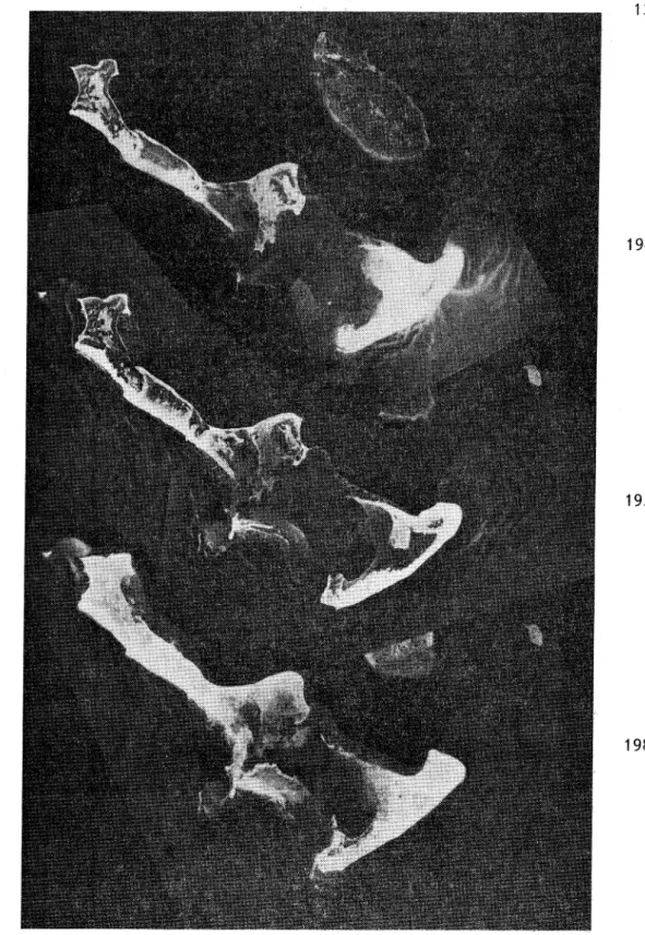
In the shallow area between Storgrunnan and Skvalpen (Fig 1, point A), sediment cores were taken with a wedge-shaped modified Klovan-type box-corer. The cores, 45 cm long and 30 cm wide, were impregnated with Epoxy to provide a relief, generally not observable directly from the cut. This technique is described in detail by Greenwood et al (1984). At a depth of 20-30 cm, inclined cross stratification indicates a NE trans-port of material by migrating bars (Fig 14).
In the narrow strip of bottom area north of the lagoon, tube cores, 7 cm in diameter, were obtained using PVC pipes, which were pounded approximately 1 m into the bottom with a sledge. The pipes were cut length-wise with the cuts in NE direction and prepared with Epoxy. The upper 25 cm active layer of the bed in core B (Fig 15) consists of horizontal small-scale ripple cross lamination indicating both landward and seaward sediment transport, induced by wave oscillatory currents, generated by low to moderate waves from the northern quadrant. At a depth of 25 cm a discordance surface with imbedded small stones is seen. From a depth of 25 cm to the bottom of the core, seaward-dipping cross-stratification with angles ranging from 8 to 30° indicate a delta-like foreset deposit.
Recent bar migration was studied on the SW side of the island. Fig 16 shows a migrating bar connected to the beach at the location of profile 10-1. In Fig 17 a cut in the bar shows the bar stratification. Under a ea 20 cm thick horizontal top-set a cross-bedded foreset of the same thickness indicates the landward migration. The bar migration here feeds the beach with material, but if no shore had stopped the bar it should have moved straight over the ground and been deposited on the NE side of the shoal.
The evolution of this group of islands has taken place by sediment transport across the shoal similarly to the migration of barrier islands
on
the American East Coast (Hayden et al 1980). However, to trace the evolution of the isles of Sandgrunnorna in more detail and to strictly verify an evolutionary hypothesis, additional studies of the sediment structures both on land and on the bottom areas are necessaryT h e g r o w t h r a t e 0 f S a n d g r u n n o r n a
One of the aims of Enequist's investigation of Sandgrunnorna was to get a measure of the rate of dune growth. The vertical growth of a number of dunes on Bakgrunnan and Mittisandgrunnan was calculated to approximately 1 m per decade. At the time of Enequist's investigation of Sandgrunnorna in 1942, embryonic dune forms occurred only on Skvalpen. The largest dune, formed around a driftwood log, was barely 1 m high and approximately 3 m long. At the time of the 1976 investigation, dunes with an average height of 3-4 m had developed along most of the SE beach. In the course of the 1976 field work, profiles were levelled perpendicular to the shoreline, around the circumference of the island. When the island was reinvestigated in 1983, the same profiles were
levelled. At profile 8 (Fig 10-2), a new dune, 30 m long and barely 1 m high, had formed in the time period between the two investigations. Furthermore,
Fig 14 (above)
Fig 15 (right)
Epoxy peel of a 30x45 cm big box core from the lagoon between Storgrunnan and Skvalpen (Fig 1, point A). The structure of inclined cross stra-tification at a depth of 20-30 cm indicates a NE transport of material by migrating bars.
Epoxy peel of a 70 cm long tube core from the bottom area north of the lagoon between Stor-grunnan and Skvalpen (Fig 1, point B). The
upper 25 cm consist of small-scale wave ripples. At a depth of 25 cm a discordance surface with embedded small pebbles is seen. Under the dis-cordance surf ace seaward-dipping cross-strati-f icated structures indicate a delta-like cross-strati- fore-set deposit.
Fig 16
Fig 17
A migrating bar, connecting the beach on the south side
of profile 10: 1 at Sandgrunnorna.
Cut in the migrating bar in Fig 16, showing the top-set and the fore-set.
an old dune had grown by almost 1 m in height in these seven years. These dune formations confirm Enequist's calculation of an average vertical dune growth of approximately 1 m per decade.
T h e g r o w t h r a t e 0 f S a n d g r u n n o r n a
A study of the historical areal expansion of Sandgrunnorna reveals that the surface area increased both exponentially, at an almost steady rate over time, and incrementally, at intervals of a decade or so (Fig 18). The exponential surface increase depends on the fact that the glaciofluvial deposits are lobe-formed; thus, the land uplift causes each newly drained area to be larger than the previous one. The incremental surface increase is due to the relatively rapid sedimenta-tion of the lagoons which produces large drained areas in a short time span. Examples of such rapid areal increase processes are the time periods between 1880 and 1903 and between 1946 and 1956 (Cf Fig 7). A new period of such rapid surface area expansion is presently taking place as the lagoon between Storgrunnan and Skvalpen is filled up.
km
25
4
3
2
Fig 18 yearDiagram showing the areal land growth. Observe the step-like growth where the fast land increase depends on filling of lagoons and bays.
The future areal gain of Sandgrunnorna will be determined primarily by the bottom topography around the island. A rough estimate, based on the assump-tion that the 6 m hypsograph will correspond approximately to the shoreline in 600 years, indicates that Sandgrunnorna will have a surface area of approximately 35 km2 by this time. Not until a thousand years from now will all the glaciofluvial deposits be lifted above the sea.
Ager, B.H:son., 1964: Studier over klimatet i Norrland, Dalarna och Varmland. Studia forestalia svecia. Stockholm.
Bygden, A., 1910: Nagra bidrag till kannedom om den sekulara landhoj-ningen vid Bottenvikens kust, YMER. Stockholm.
Bird, E.C.F., 1968: Coasts. Australian Nat. Univ. Press. Camberra.
Dabrio, C.J., 1982: Sedimentary structures generated on the foreshore by migrating ridge and runnel systems on microtidal and mesotidal coasts of S. Spain. Sediment. Geol., 32:141-151.
Enequist, G., 1944: Dynstudier i Lule skargard. Ge.ographica 15. Uppsala. From, E., 1965: Beskrivning till jordartskarta over Norrbottens lan
nedanfor lappmarksgransen. Sv Geol Undersokn, Ser Ca 39. Stockholm. Grano, O., 1981: An emerging esker in southern Finland. Geogr Ann 63 A
(3-4). Stockholm.
Greenwood, B. et. al., 1984: A Klovan-type box corer for use with SCUBA. Ceo-Marine Letters, Vol. 4:59-62.
Hayden, B.P. et al., 1980: Barrier island migration. Thresholds in Geo-morphology. Ed. Coates, D.R. and Vitek, J.D. George Allan and Erwin. London.
Jarnefors, B., 1949: Wave washing phenomena in the coastal district of Norrbotten, Bull Geol Inst Val 33. Uppsala.
Lundkvist, J., 1982: Landhojningen och landskapets omvandling. Landhoj-ning och kustbygdsforandring. Nordiskt Symposium. Lulea.
Nordebo, B., 1956: Strandbildningar och kustlinjeforandringar i Neder-kalix och Nedertornea socknar. Geografisk proseminarieuppsats. Stockholms Hogskola.
RAK, 1971: Geodetic activities in Sweden 1967-1970. RAK, Rikets Allmanna Kartverk. Medd A 38. Stockholm.
U.S. Army Coastal Engineering Research Center, 1977: Shore Protection Manual, Volume I.
Zenkovich, V.P., 1967: Processes of Coastal Development. Oliver and Boyd. Edinburg and London.
PUBLISHED MAPS
Generalkarta till Sveriges sjoatlas, del 2, av Johan Nordenankar. 1790. Ekonomiska kartverket. Neder-Lule harad. 1868. Samma kartblad oversett
och rattat. 1880.
Generalstabens karta over Sverige. 1:200 OOO. Blad 45. Rodkallen. 1903, uppmatt 1877 och 1891.
Generalstabens karta over Sverige, konceptblad. 1:50 OOO. Blad 45. Rod-kallen NV och NO. 1929.
Sjokort nr 102 Lulea 1:100 OOO. 1923. Utg av Kungl Sjokarteverket. Ekonomisk karta over Sverige. 1:10 OOO. Blad 24 M 3a-c, 4a,b. Sannna
kartblad reviderade 1948.
Topografisk karta over Sverige. 1:50 OOO. Blad 24 M SV 1969. Samma kart-blad reviderat 1979.
UNPUBLISHED MAPS
Geografisk Maculatur upp i Tornea, Kal , Ranea och Lulea Socknars
Skar-gard uti Westerbottens Norra Contract ar 1721 av H. Kruse. Krigs-arkivet.
Karta of er Segelleden till Lule a Stad 1764 av Fr. Bodin. Riksarkivet. Grundkarta. Litt XVI nr 6, IV. 1:20 OOO. 1826. Krigsarkivet.
Karta till Militargeografisk beskrivning over Vasterbottens kustland av Raab. 1829. Krigsarkivet.
Karta ofer de lodningar som blivit gjorda i Botten Wiken fran Svenskar till Maloren med H M Konungens Skonert Falk ar 1841. Krigs-arkivet.
Transportkarta i skala 1:80 OOO over Nederlulea socken av E. Hallstrom
(A 23 113, LA). 1842. Lantmateriverkets arkiv.
Avvittringskarta over Sandgrunden av L. Ruuth. 1873. Lantmateriverkets arkiv.
VERTICAL AIR PHOTOGRAPHS
National Land Survey of Sweden: Photographs BD sk 46 03 02, BD sk 46 03 03, BD 56 243h 05, BD 56 245d 02, 62 Mb 241 05, 66 Mb 241 04, 73 Mab 243 01, 78 424 221 03, 809 240 233 33.