Scientific Press International Limited
Sammara and its Canals
Nasrat Adamo1 and Nadhir Al-Ansari2Abstract
As the history of this land continues to unfold, we come to the time when the capitol of the State was moved to a new city to the north of Baghdad, which was called Samarra, and this was the opportunity taken by the Khalifahs to build new palaces and excavate new canals and open more land for cultivation. In this paper details on the building of Sammara by Khalifah al- Mu’tasim, son of Khalifah Harun al- Rashid and moving the capitol to it from Baghdad in the year 836 and remaining as such until 892 are given. One of the main reasons which led al-Muʿtaṣim to build Samarra and moving to it was the problems raised by the presence of his Turkish slave-soldiers in Baghdad and the friction they had created with the population. Al-Muʿtaṣim construction works in Samarra, the various public buildings, and numerous palaces he constructed here are described. As the city was located on the eastern bank of the Tigris, water supply could not be drawn to it by gravity since its location was higher than the river and even higher than the Katul Kisrawi canal adjoining to it from the east. Therefore, the irrigation works of al- Muʿtaṣim were concentrated on the western bank of the Tigris, which he had already connected it to the right bank by building a bridge. The main irrigation work he embarked upon was the construction of Nahr Ishaqi Canal. This old canal dated to the Partho- Sassanid era but it had to be re-excavated and remodeled since it was already filled up by sediments and abandoned. More over the canal had to be extended for a very long distance downstream to irrigate all the qati’as he had given to his top generals and courtiers to develop into cultivations and farms. These farms then produced all sorts of crops and fruits while the large date palm orchards planted here gave the best types of dates. Moreover, the canal in its downward route supplied water to the large tract of land that al- Mu’tasim had reserved for the encampment of his Maghariba troops which was called “Istablat”. Details of the barracks, housing quarters, stables and training arena of the encampment are presented in addition to the three branch canals off taking from Nahr Ishaqi, which were to irrigate also the
1 Consultant Engineer, Norrköping, Sweden.
2 Lulea University of Technology, Lulea, Sweden.
Article Info: Received: February 10, 2020. Revised: February 15, 2020.
extensive pastureland that was reserved for the 140,000 cavalry horses to graze in. The canal was then followed to its end in the other old canal called al- Dujail canal. The works of al- Mu’tasim, however, were no match to what his grandson al- Mutawakkil had done which are described. This Khalifah was determined to irrigate Samarra by gravity from the Tigris and to have plentiful water supply to the city and to his palaces and to his many artificial ponds. He embarked on a daring project by constructing a dual kariz and open channel conduit system taking water from the Tigris at a location forty kilometers north of Samarra and running for great part of its length along the Katul Kisrawi canal adapting to the hilly topography of the land. The scheme was then described following its course after crossing the Katul by an aqueduct to an earth reservoir. This reservoir was built to retain the incoming water before distributing it to the main city dual Kariz, and to the canal supplying the Dakka palace. In addition to the flood escape channel that was known as the Nahr Murayr which took off from the west side of the reservoir and passed down to the Tigris where it poured. The main city Kariz system is followed i and the details of its branching network are fully described. Such details covered the water supply to the racing courses, the Dar Khilafa palace and its unique pools intended for the Khalifah’s pleasure and the water supply to Abu Dulaf Mosque congregational mosque with its famous fountain. Having finished in the Tigris at al- Matira this stream could not irrigate the 5000 hectares of land of al- Hayr, or the wild animal reserve created by al- Mutawakkil to practice his hobby of hunting, as this land was above its course. The al- Hayr was so important to al- Mutawakkil that he excavated a new canal directly from the Katul, which commanded the whole area, called it Nahr al Nyzak and gave from its final reach a branch to another palace he built there and supplied one more of his favorite ponds adjoined to it. The construction works of al- Mutawakkil were not confined to Samarra but he extended this to build a new city 18 kilometers to the north of Samarra and called it al- Mutawakkiliyya, and here he again built new government compound, a mosque and gave qati’as to his sons, generals and may more people to build houses and palaces. He built for himself another palace and called it al Ja’fari. To supply the new city with water, he ordered the excavation of a new canal, which he called Nahr al Ja’fari. The intake of this canal was on the Tigris River some forty kilometer north of Tikrit and it followed a course parallel to the river for a considerable distance before it crossed the Katul Kisrawi by an aqueduct and then entered the city. This project proved an engineering failure as the ground, which had to be dug, was extremely hard and the work had to be stopped after spending twenty five million dirham. While some of these works may be considered as grand works, they were very costly and deprived public works such as irrigation networks from their share necessary for their maintenance and proper functioning. This extravagance coupled with political intrigues led to the assassination of al- Mutawakkil in a plot that was planned by his own son. This point marked the beginning of the decline of al- Khilafa which took some more time till it finally collapsed in 1258 fall of Baghdad on the hands of the Mongols. In addition to Samarra and its irrigation work described also the Nahr Dujail canal flowing on the western bank of the Tigris not far downstream from
Samarra. Much older than Samarra itself, it was irrigating a large tract of land extending to Baghdad. In description of the course of the canal followed its western branch, which had gone out of use at the Abbasid times and also concentrated attention on the eastern branch that was known as Nahr Batatiya. It irrigated the Tusuj of Maskin before it reached the northern parts of Baghdad and branched into a dense network of watercourses that supplied al- Harbbiyyah quarter. Further details are presented of the various places and parts of this quarter that benefited from these watercourses before the full supply was exhausted. The details as given augment therefore the description of the canal networks serving Baghdad (the round city and the Karkh districts) that had originated from Nahr Isa. The Abbasid Khilafa after it had experienced its golden era began after the assassination of al- Mutawakkil, a long process of slow but steady decline due to multiplicity of reasons. Keywords: Sammara, al- Dujail, Nahr Isa, Kariz system, Iraq
1. Sammara
In the history of the Islamic Khilafa, the construction of new canals and the revival of old once was always associated with the establishment of new cities, not only for irrigation and expanding agriculture around these cities, but also for providing drinking water supply, ablution water for the mosques and for the supply of pleasure pools and fountains. This was the case for Basreh, Wasit, Kufah, Bagdad, and finally for the last one Samarra.
Samarra was built by the eighth Abbasid Khalifah al-Muʿtaṣim biʾllāh, who ruled from 833 AD until his death in 842 AD. A youngest son of Khalifah Harun al-Rashid, he rose to prominence through his formation of a private army composed predominantly of Turkish slave-soldiers (ghilmān).Those he bought from Samarkand, Khwarazm at the fringes of the Muslim world in Central Asia and from other high ranking people in Baghdad who owned many of them. His inclination towards these Turkish slave soldiers was because his mother was a Turk, and that he wanted to avoid the fierce competition between the Arabs and Persians that occupied government and army positions. One of the main reasons, which led al-Muʿtaṣim to the building of Samarra and moving the capital of Khilafa there, was the problems raised by the presence of these Turkish slave-soldiers in Baghdad.
Although this private force numbered in the beginning between three thousands and four thousands, they often came into conflict with the city's populace who resented their presence, being foreign troops, and who were furthermore, often undisciplined, arrogant and violent. They were used to run their horses in the crowded markets of Baghdad causing havoc and trample people under their horses and even causing the death of some. The reaction of the mob in those cases was overrunning and killing them, which disturbed and saddened al-Muʿtaṣim and made him decide to move to a new city that he would build.
In his search for a new site of the future capital, al-Muʿtaṣim inspected many locations to the north of Baghdad. After rejecting many sites such as Bardan, Bahamsha, al- Matera, he decided first to build the city on the Katul- Kisrawi, but he abandoned the idea as the place was gravely with not much soil. Finally, his choice fell on the present site not far from the Katul Kisrawi at the place known as at-Tirhan on the east bank of the Tigris that belonged to a Christian monastery monks which he bought from them for 4000 dinars [1],[2].
He favored the new site because of its fresh air and for being close to al-Hayer, which was a very good and rich hunting ground. In laying out the city, al-Mu’tasim saw that the Great Mosque was at the heart of the city, while the court of the Khilafa and his residence in Kasr al Jawsaq (palace) was very close to the north of the Mosque. The various markets were planned and built around the Mosque, one market for each profession following the example of Baghdad.
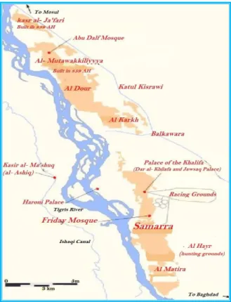
Figure 66: Map of Samarra and its surroundings showing al- Mutawakkiliyya which was built later on by Khalifah al- Mutawakkil, (modified from source in
reference)[3], [4].
Residential areas were separated from the markets, and the militaries were given their own cantonments, separated from the ordinary populace. The Turk leader, Ashinas and his “atrāk” soldiers were given qati’as (land Grants) at the place known al-Karkh, while the Uzbeks from Fergana and their leader Khan Artuj were settled close to al-Jawsaq Palace. Al-Afshin and his Persian troops called
Shakiriyya troops were located to al- Matira to the south. Al-Mu’tasim following
the extravagance of his predecessors ordered the building of other palaces for himself at various locations in and around the city such as al- Umari and al- al- Waziri palaces, Figure 66.
Unlike Baghdad, the new capital was an entirely artificial creation, poorly sited in terms of water supply and river communications. Irrigation water could not be brought to the city from the nearby Katul due to its higher elevation, and it seems that irrigation water was taken out of wells. Ibn Rusta tells us that drinking water was carried on the backs of pack animals to where it was needed in the city and that there was a large number of them in town[1].
When al-Mu’tasim finished surveying and laying the foundations of the buildings on the east side of the Tigris, he then built a bridge to the west side of the Tigris. There, the land was different from the right bank, mainly fluvial and fertile, so he established there cultivated areas, orchards and gardens; he had canals dug from the
Tigris, and each military commander was entrusted with the development of one part. Date palms were imported from Baghdad and Basrah and other areas of the al-Sawad, and plants were brought in from the Jazira, Syria, al- Jabal, al- Rayy, Khurasan and other regions. Water was plentiful for these cultivated areas on the west side of Samarra. The date palms flourished; the trees took roots; the produce ripened. The fruits were excellent, and the herbs and vegetables were good. People planted various kinds of crops, herbs, vegetables, and succulent plants. Because the land had been fallowed for thousands of years, wherever was planted it flourished, so much so that the revenue from the cultivated areas along the canals had so much increased from the locations known as the Ishaqi Canal and alongside it, the Itakhi Canal, the ‘Umari Canal, the ‘Abdul Maliki Canal, the Masruri Canal and the Sif Canal, in addition to the five villages of al- ‘Arabat al- Muhadditha, and the seven lower villages. The orchards, and gardens revenue, plus the Kharaj taxes on agricultural property amounted to 400,000 dinars a year, while the income that came from the city and its markets amounted to 10 million dinars a year[4].
The Nahr al-Ishaqi irrigation canal was one of the largest schemes that were attributed to Al-Mu’tasim; as in his grand work he embarked on the revival and development of this old canal, which was originally an ancient canal that had its intake 10 kilometers downstream from Tikrit. To achieve this new development, al-Mu’tasim tasked his police chief, Ishaq ibn Ibrahim al- Khuza’i, to oversee the construction of the project which was named after him, although it might have been named after al-Mu’tasim himself, for his agnomen (kunya) which he was commonly known by, was abu Ishaq[5].
The scheme consisted of two parts; the first was the re-excavation and re-modeling of the upper reach of the old canal which appeared to belong to Partho- Sassanian times and was abandoned at this time. It had run in southerly direction for about four kilometer parallel to the Tigris River and passed the locations of al- Huwasilat, al Ashiq Palace, and al- Salibiya. The second part was the newly excavated reach, which departed from the old course after twelve kilometer to the south of al- Salibiya and then flowed in a southeasterly direction. The remnants of the old canal show that it had continued in southwesterly direction for forty more kilometers and had irrigated the land between the Tigris and Euphrates until it ended in Akarkuf depression west of Baghdad.
The new canal continued its course all the way southwards to the Istablat military camp forming part of its fortifications, and supplying it with water, as we shall describe later. The canal having left Istablat camp continued in a sinuous course south from the camp for another thirty kilometers to end in the old Dujail canal[5],[6],
Figure 67.
At al- Huwasilat, see Figure 66, the remains of a very large palace are seen today, which belonged most probably to Kasr al- Juss palace built by al-Mu’tasim for his pleasure and mentioned by Yaqut in his “Mu’jam Al Buldan”[7]. The buildings had
an area of more than nineteen thousands square meters while the outer walls of the palace grounds contained an area of one hundred and thirty thousand meters. The palace ground was located on the Tigris River itself and extended to the left
bank of Nahr al- Ishaqi canal, so it may be assumed that the palace gardens were irrigated from canals that branched from the Nahr al- Ishaqi and poured back their remaining waters into the Tigris.
The other remarkable palace that was built on the right bank of Nahr al- Ishaqi canal and 16 kilometers from the modern city of Samarra was Kasr al-'Ashiq (The Lover palace). It was located on higher ground than the level of the canal itself and had a sweeping view of the Tigris River to the east. The palace was built by Khalifah al- Mu'tamid who had reigned from 870 to 892, and was the last Khalifah to stay in Samarra before shifting the capital back to Baghdad by his brother and successor al- Mu”tatid.
This palace is a prominent surviving example of the Abbasid architecture, and one on which the Iraqi Department of Antiquates and Heritage had saved no effort in its restoration during the 1980s, Figure 68. The building has a rectangular shape of 140 meters and 93 meters long sides, which is surrounded by an outer wall of 230 meters and 178 meters of side lengths. The building consists of two floors; the lower one was formed of catacombs and vaults, while the second was for residence and other functions. Outside the walls exists a long moat but as the levels of the palace and the moat were higher than the water level of the adjoining Nahr al- Ishaqi so water supply was drawn from an underground channel (Kariz) which flowed from the western higher land, Figure 69.
Figure 69: Overall view of al- Ashiq palace showing the Tigris River in the background [8].
Flowing south still, Nahr Ishaqi canal came to the site of Istablat (Stables); this was a very large encampment established by Khalifah al-Mu’tasim when he moved to Samarra, and it was intended as a military camp for his troops “the Maghariba”, a military unit apparently of Egyptian origin[9], [10].
The total area reserved for the camp was 233 hectares, but the area of the establishments as seen today has an area of 111 hectares. The location of the site is on the west bank of the Tigris River at a distant of about 15 kilometers south from the modern city of Samarra, Figure 70. Its plan consisted of a small rectangle containing the palace, which was adjacent to a larger rectangular area reserved for the army. The palace ground was 500 meters long and 215 wide, and its remnants were thought by Professor Northedge to be the palace of “al- Arsh” built by the Khalifah al Mutawakkil, the grandson of Khalifah al-Mu’tasim. The length of the larger rectangle is 1700 meters, and the width is 550 meters. This part was intended for the housing blocks occupied by the army commanders, officers, and the soldiers’ barracks in addition to the training fields and stables for the cavalry. This whole encampment was surrounded by a massive wall[11].
Figure 70: Istablat Camp site south of Samarra [9].
The barracks were to house 250,000 soldiers, and the stables are said to accommodate 160,000 horses[10] and the remaining part of the site contained pasture
land for feeding the horses.
The camp area was served with water by Nahr al- Ishaqi, which had its alignment so chosen as to run along parts of its western and southern peripheries forming at the same time part of the camp fortifications.
Three canals branched from Nahr al Ishaqi and entered the site of Istablat. The northern branch passed across the camp to the northwest of the barracks and ended in the Tigris River after skirting these barracks. The middle branch bifurcated from the main canal at a point 1800 meters south of the northern branch intake and crossed through the barracks to end in the Tigris River also.
Just downstream from its intake, one cross weir was constructed on Nahr al-Ishaqi canal to raise its water level and feed this branch; the remnants of this weir are seen today as brickwork piers indicating three openings. As for the third branch which branched from the main canal at about 500 meters to the south from the middle
branch intake, it ran between the main canal and the outer boundary of the camp for considerable distance and entered the camp from its southwest corner to leave it after a short distance. It then traversed some distance to join the Dujail canal afterwards at a point located about four and a half kilometers above the point where Nahr al Ishaqi canal itself ended in the Dujail canal also.
Similar to the middle branch, a second cross weir was constructed across the main canal in order to raise the water level and feed it while two crossings were built on the main canal south of the intake of the last branch to allow access to the camp area.
When Khalifah al-Mu’tasim died in 842, he had left already a legacy of many buildings and construction works, which had made of Samarra a flourishing city, and made its cultivations on the left bank a source of food for the population. This is not to say that these lands were not productive before. The area of cultivation had increased many folds due to the re- excavation of the upper part of the old Nahr Ishaqi canal and extending it further south towards the Dujail canal that stretched down to Baghdad and irrigated its northern quarters.
Khalifah al-Mu’tasim is also credited for building many grand palaces for state functions, residence and for pleasure and entertainment. These were Kasr al- Jawsaq, Kasr al- Abdul Maliki, Kasr al- Juss, Kasr al- Kusur, Kasr ‘Amoriyya’, Kasr Al Mathameer, Kasr al- Amani and Kasr al-Khaqani,[12]; al- Ya’qubi adds two
more palaces; Kasr al Umari and Kasr al Waziri [13]. It is also known that he built
the Kasr al- Haruni for the residence of his son al- Wathiq.
With respect to the other public works that Khalifah al-Mu’tasim completed, it is fitting to mention the grand congregational mosque, and the wild animal reserves al- Hayr which he established at the southern part of Samarra, see Figures 66 and 67 [14].
It was not unusual for the Abbasid Khalifahs to have such wild animal reserves. Khalifah al-Ma‘mun, for example, who was al- Muʿtaṣim’s older brother had a similar reserve established in his palace al- Hasani in Baghdad to please his wife Boran, and he brought water to irrigate its grounds by digging a branch canal from Nahr Al Mu’alla canal [15].
The area of al- Hayr was only 100 hectares, but it was Khalifah al-Mu’tasim grandson, Khalifah al-Mutawakkil (847-861), who enlarged it later on to have it as both an animal reserve and hunting area.
In considering all the water works constructed in Samarra during its time as the capital of al- Khilafa, we find that al- Mutawakkil was much more ambitious than his grandfather Khalifah a-l Mu’tasim, for al- Mu’tasim was contented with the supply of drinking water to the city from the Tigris River carried in leather bags by pack animals. He instead of attempting to irrigate the city itself turned his attention to the right bank of the Tigris by reviving the upper reach of Nahr al-Ishaqi canal. Al- Mutawakkil, on the other hand, had a special interest in grand public works, so he decided to bring water to the city by digging canals and allowing water to flow by gravity to supply his palaces and pleasure pools and other places of interest. In this work, he undertook a series of challenging schemes in spite of the undulating
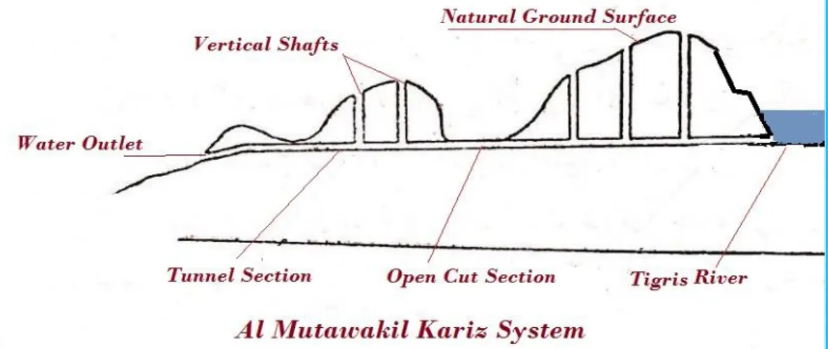
topography and the hard conglomerates that formed most of the terrain where these works had to be excavated. The largest of these undertakings was the scheme named after him as the “al- Mutawakkil Canal.” However, to say the truth this was not strictly an open channel, but it was a series of open cuts and tunnels that followed the topography of the ground and stretched its length penetrating high grounds at some parts and flowing in an open cut in others. The system used was similar to the Kariz system but in a reverse fashion, as illustrated by Figure 71 and Figure 72.
Figure 71: Normal Kariz Excavation Method.
Figure 72: Khalifah al- Mutawakkil method of Open cut and Kariz Excavation.
Normally any Kariz is tunneled through a hill or higher land and driven upwards towards a water bearing aquifer. By this way water is allowed to flow towards the surface at the entrance. The excavation process of any Kariz is carried out by
digging the tunnel together with vertical shafts or wells along the axis of the tunnel under construction. The shafts allow the removal of the excavation materials up to the ground surface and provide additional access for the workers. More shafts are dug as the work progresses at regular and comfortable intervals until the end of the Kariz is reached in the prescribed point. In al- Mutawakkil project, excavation work started from the inlet on the Tigris River and tunneling work continued in a downward slope using the Kariz arrangement for the distance required, which reminds us of Sinnecharib’s Bastora-Erbil project, which was described in paper (4).
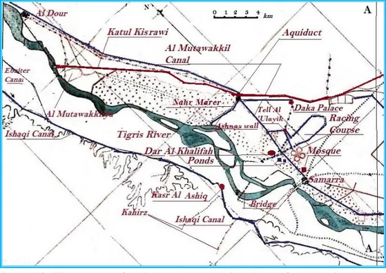
The general slope of the natural ground helped in directing this tunnel towards the low lands where the water was needed. In this scheme, the water channel was formed by two identical and parallel watercourses, which had their entrances located on the Tigris River at a location north of al- Dour at about 40 kilometers north of Samarra. The two watercourses ran into a combination of Kariz and open cut construction, which was decided by the topography and the ground surface elevation. The two watercourses ran in two separate Karizs for the first few kilometers, parallel to the Tigris River, after which the left hand Kariz ran for two kilometers in open cut and then continued in a Kariz tunnel alongside the right hand Kariz. They both went through al- Dour in this manner and then followed the left bank of the Katul Kisrawi canal; the upper feeder of Nahrawn Canal.
After twenty kilometers south of al- Dour they appeared again in two separate open cuts for the next few kilometers where they united in one open channel, which turned down and crossed the Katul at kilometer 22. This crossing was affected by a large aqueduct which was constructed on the Katul at this point.
The purpose of constructing dual watercourses instead of only one was to use one of them during the low water season when the water level in the Tigris is low, and to use the second one to pass the flow during floods and high water seasons. This arrangement was similar to the two feeder canals (a-l Qaim and al- Sanam) of the Nahrawn Canal which was fully described in paper 9.
The excess floodwater entering to the Kariz at al- Dur could be drained later on to the Tigris River by special drainage channel after the combined watercourse had crossed the Katul as shall be explained later. Moreover, as the Tigris River normally carried heavy silt and sediment loads during floods, it was necessary to construct a number of desilting basins along this watercourse to reduce the quantity of sediments and silts carried down to the users. These settling tanks or earthen reservoirs were similar to the desilting basins usually used in modern practice for very large irrigation canals in the world today.
The provided desilting basins were called in Samarra by “Dahader” and the accumulated sediments were dredged regularly and the materials were placed on the peripheries. The aqueduct, which carried the flow of the combined watercourses across the Katul Kisrawi, must have had its bottom about 3.5- 4.0 meters above the bottom of the Katul; which was concluded from surveying of the remnants of both the Katul and the watercourse.
earthen tank in the form of reservoir, which was located at the western side of the Katul, so that two secondary branches emerged from this reservoir in addition to the main stream forming the backbone of the scheme.
The first secondary branch was called Nahr Murayr, which was, in fact, the floodwater escape channel, which took the excess water carried by the Kariz from al- Dur. This channel was twenty meters wide and three kilometers long, and it ran westwards alongside the eastern side of Ashnas wall and ended into the Tigris, therefore, draining the excess floodwater that had reached the reservoir. The intake of Nahr Murayr was provided with regulating structure to control the discharge according to the needs.
The other secondary branch ran eastwards alongside the Katul Kisrawi itself until it reached the palace known as al- Dakka Palace, which was built on the right bank of the Katul and was overlooking it. Two arched masonry bridges spanned the canal at a distance of 50 meters before and after the palace. The canal, itself passed below the palace in masonry vault and emerged from the other side. The canal also supplied water to a small pond, which was located at the southern front of the palace. The main stream intended to supply the city emerged also from the reservoir and flowed southwards towards Samarra in the usual open cut and Kariz combination, and reached it after traversing a distance of forty kilometers measured from the beginning of the scheme at the intakes on the Tigris River.
In and around Samarra, the Kariz supplied the various districts and places of importance by a series of secondary Karizs or canals. In Figure 73, the course of the main scheme is shown from the intakes down to below Samarra. In the lower part of the figure, Nahr Ishaqi canal is shown on the right bank of the Tigris River.
Figure 73: The course of al- Mutawakkil main scheme from the intakes to below Samarra. At the lower part on the right bank of the Tigris River the Ishaqi canal is shown. (Note the matching line A-A in this map with the same
in the next map of Figure 74).
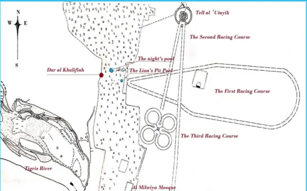
The first secondary Kariz that bifurcated from the main watercourse went eastwards towards an artificial mound called “Tell al ‘Ulayik, which overlooked the racing arena. So it may be assumed that the mound was constructed probably for the
Khalifah to watch down on the racing arena during races and tournaments. The water from this secondary Kariz poured into a trench which circulated around
the mound in full circle and discharged back into another Kariz to take the returned flow back to the main scheme. Meanwhile, the trench supplied an open canal which went around the periphery of the main racing course, so that its water could be used to sprinkle and wet the ground before the events and prevent too much dust being raised by the running horses. An enlarged part from Figure 73 is given in Figure 74. It shows Tell al ‘Ulayik and the racing arena which was formed from three racing courses; the watercourse of al- Mutawakkil main scheme is not shown as it was in the form of Kariz and the full description of the racing arena and Tell al ‘Ulayik are given in reference [6].
Figure 74: Tell al ‘Ulayik and the racing arena formed of three racing courses; the watercourse of al- Mutawakkil main scheme is not shown .Note
the location of Dar al- Khalifah and the water pools on the left, and the Milwiya congregational Mosque at the bottom[6].
One interesting story which was circulated those days on the origin of the name of Tell al- ‘Ulayik had said that it was meant to show the power of al- Mutawakkil and the great number of horsemen in his army in that, the Khalifah had ordered each one of his 90,000 horsemen to carry one full saddle bag (‘Ulayika) of earth to the site of the Tell (mound). Therefore, it was built from all the earth that was carried by those ‘Ulayikas [6].
As the main watercourse continued its way downwards, it passed on the east side of Dar al- Khalifah which was the Khalifah palace and his normal residence. Through a branch, Kariz water was poured in a peculiar pond, which was, located about 600 meters southeast of the palace; it was called by many names such as al- Zindan, or al- Hayba, but it was commonly known by the name of the lion’s pit.
This pond was excavated in petrified conglomerate in the form of a square measuring about 20 meters on each side and had a depth of about 10 meters. At the bottom of this pit, a circular pool was dug and filled with water from the branch Kariz, and the excess water was then guided into another Kariz to be drained into the Tigris and prevent water from over flooding the pit. The pit itself had large recesses in the shape of rooms excavated in the walls and overlooked the pond. For relaxation The Khalifah and his entourage may have used these rooms after swimming in the pool during the burning heat of summer days while enjoying the cool air inside the pit. Speculations go as to saying that the pit was probably roofed
to shelter it from the sun and to be like a cellar or crypt. The entrance to the pit was through a gallery in the form of a descending staircase, which opened to the recess in the fourth side of the pit.
This pool, it seems, was not enough for al- Mutawakkil, for he needed an open-air pool to spend the evenings and part of the night by it; and therefore, a second pool was dug, which was bigger than the first and deeper. It was excavated in petrified conglomerate also and was circular in shape with a diameter of about 115 meters, and it was supplied with water drawn through one more Kariz and fed from the first pool.
As this pool being used during evenings, it was therefore called the night pool. From the main scheme, one more Kariz supplied water to the grand congregational mosque known as “Abu Dulaf Mosque” which was one of the famous construction works of al- Mutawakkil. This mosque had one 52 meters high spiral minaret known today as the “al- Malwiya” which is still in existence and visited by many people, Figure 75.
The mosque had a very large fountain located in the center of the spacious courtyard and it was mentioned by al-Ya’qubi as “the constantly flowing fountain” [16].It was
in the form of an elevated cup made of one piece of marble and named the (Firau’n’s Cup) or the (Pharaoh’s Cup) due to its large size and streamlined form [17].Water
over flowed from the cup into a circular basin which measured 23 dira ‘or (12.43 m) in diameter [18].The cup itself was raised on a circular base in the center of the basin and elevated to a height of 7 dira ‘(3.79 m) and it had a thickness of one half dira ‘(0. 27 m). The basin itself was built from masonry of brickwork bonded by lime and ash and engraved with Islamic motifs and decorations in gold color mosaics and colored glass. The whole arrangement suggests that a closed conduit under pressure supplied the flow.
In 1911- 1912, the site of the mosque was excavated by the German Archaeological Expedition headed by Dr. Herzfeld, and a lot of marble blocks and other ornamental parts made from gypsum were unearthed from around the fountain[18].
Figure 75: A recent photograph of al- Malwiya minaret of the Abu Dulaf congregational mosque built by Khalifah al- Mutawakkil during 848-851.
The Kariz watercourse continued towards al- Matira, a small village about two farsakh (12 km) south of Samarra, which was located on the Tigris after supplying water to all these important locations. Al-Matira was qati’a that was originally given by al- Mu’tasim to his general al-Afshin where he had built his residence, a small market, as well as a mosque and baths. But following al-Afshin execution in 841, Matira was granted to the Turkish general Wasif by the Khalifah Wathiq, al-Mutawakkil’s father [19].
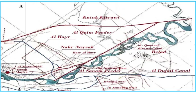
From al- Matira the stream continued in its courses to pour the remaining flow into the al- Qaim which was the feeder canal of the Nahrawn Grand canal, as shown on the map in Figure 76.
This map also shows clearly that al-Mutawakkil canal ended below al- Hayr, and it could not possibly supply it with water due to the opposite grade of the land; and
the case being so al-Hayr reserve had to be irrigated by another canal, which was excavated by al-Mutawakkil and called Nahr Nyzak.
The Khalifah al- Muʿtaṣim’s Hayr mentioned previously was called by al-Ya’qubi as Haier al- Hayr to differentiate it from al- Mutawakkil’s Hayer [20]. In fact, Haier
al- Haier had occupied only the 100 hectares of land east of the congregational mosque, at the southwestern corner of al- Mutawakkil Hayr, but Al- Mutawakkil’s plan, in fact, was to use most of the plain south from the Katul Kisrawi down to the Nahrawn feeder al- Qaim Canal (which had been re- excavated by Khalifah Harun al- Rashid who had renamed it as Nahr AbuI el- Jund after he closed the intake of al- Qawrach (refer to paper 9).
The area of al- Mutawakkil’s Hayr was about 5000 hectares; which he surrounded by a mud brick wall, and then released inside it wild animals and birds such as doers, gazelles, and ostriches, but predators such as lions and the like were kept in cages in a small enclosed area.
The problem, which had faced al- Mutawakkil in the beginning, was his intention to irrigate the al-Hayr by re-excavating the old al- Qadisiyya canal. This canal branched from the Katul Kisrawi and it was originally intended to bring water to al- Qadisiyya fort (the Octagon) where Khalifah Harun al- Rashid had started to build a palace he had called al- Mubarak but left it unfinished[21]. Al- Mutawakkil found
out, however, that al- Qadisiyya canal intake had silted up completely. Moreover, it could not irrigate the whole al- Hayr area during summer, therefore, he decided on a completely new solution by building a cross regulator on the Katul at kilometer 30 to raise the water level and feed a new canal he excavated commanding the whole area. The remnant of the canal intake structure is still visible today, which reveals its four openings; and it shows that it was of the same masonry construction that was used those days in similar structures.
The construction work was completed in the dry on the right side of the Katul before the flow was diverted into it once construction was complete. The new canal, which al- Mutawakkil called the Nahr Nyzak (Meteor) ran for the first two kilometers parallel to the Katul before it turned towards the south for another 14.5 kilometers going through the whole Hayr; but as the course of Nahr Nyzak approached the lower boundary of Hayr, it gave one branch, which supplied another of al-Mutawakkil ponds that was called “Al Burka Al- Ja’fariyya”.
Here the Khalifah had built another palace and called it Kasr al- Hayr; a spacious palace of 20000 square meters overlooking the pond, which was in the form of square with an area of 40,000 square meters. The pond was mentioned in the poems of al- Buhturi, who was one of the most famous poets of the time who compared it to a “Beautiful Lady” [22]. Nahr Nyzak itself ended in the Tigris River.
Figure 76: Map showing the finishing point of al- Mutawakkil canal, al- Hayr, Nahr Nyzak. Also are shown Al- Ishaqi Canal and al- Dujail canals at
the lower part of the map. (Note the matching line A-A in this map with the same in the map of Figure 73).
In reality, al- Mutawakkil construction of these canals was not out of his desire for development of agriculture and expanding cultivable lands, as it was the case for all the previous Kings and Khalifahs. It was out of personal fancies and selfish desires and whims to own large number of palaces and ponds and devote them for entertainment and pleasure. Yaqut al- Hamawi in his Mu’jam al- Buldan (Book of Countries) lists about 19 palaces, which al- Mutawakkil had built. He spent more than two hundreds and ninety four million dirham on their construction [23]. As if
this entire building spree was not enough to satisfy his aspirations and vanity, so he began the building of a new city in 859 and moved to it in 860 which he named al Mutawakkiliyya, that was also called by some authors al- Ja’fariyya in reference to his new palace there which he had called al- Ja’fari, and since his full name was Abu al- Fadhl Ja ‘far al- Mutawakkil.
The location of the new city was about three farsakh (about 18 km) north of Samarra at a place called al-Mahuza, between the Tigris River and the right bank of that part of the Katul Kisrawi known today as Al Russasi Canal. In addition to his new palace, al- Mutawakkil built new government offices, a new congregational mosque similar to the one he had previously built in Samarra, and distributed
qati’as of land to his sons, army generals and soldiers, officials and many others to
build residences for themselves.
Then he surrounded the city with a wall but keeping his palace outside this wall on the bank of the Tigris River. To supply the new city with water, he ordered the excavation of a new canal which he called Nahr al Ja’fari. The intake of this canal
was on the Tigris River some forty kilometer north of Tikrit, and it followed a course parallel to the river for about sixty kilometers before it crossed the Katul Kisrawi (al Russasi Canal) by an aqueduct and then entered the city.
The work was entrusted to two courtiers who ignored the talents of a local engineer and gave the work to Abu al- Abbas ibn Mohammad ibn kuthyer al Farghani, an astronomer and writer but not much of a specialist in such works. His calculations of the grade of the canal proved to be wrong, and it turned that the excavation of the canal should be much deeper than calculated in order to have enough flow going through it. The work could not go any further by deepening the excavation due to the nature of the ground, which was of very hard conglomerates.
The project proved to be a big failure and therefore, was called off after spending one million Dinar or 25 million dirham; one dinar being equivalent to 25 dirhams in the days of al- Mutawakkil [24],[25].
Al- Mutawakkil, far from being pious Khalifah as would be expected from all Khalifahs, was sunk in debauchery and habitual drinking, and as described by one writer he was the “Nero of the Arabs”[26] in reference to his policies towards
non-Muslim minorities. Moreover, most historians consider his reign as the beginning of the decline of the State of al- Khilafa, which was marked sharply by the deterioration of its economy. His extravagant attitude was the subject of talk between the people of the time who were saying, “What was saved by al-Ma’mun, al-Mu’tasim and al-Wathiq was wasted completely by al- Mutawakkil”.
This spending and the noticeable decrease in the Kharaj collection during this time marked a sharp decline in agriculture, which formed the main source for this Karaj. Up to this period, all the previous rulers of Mesopotamia, including the recent Khalifahs had saved no effort or expenditure in maintaining the large and complex irrigation system of al- Sawad land, but this did not happen during this time, which had marked a period of carelessness and neglect.
Therefore, al- Mutawakkil was not responsible only for wasting the public treasury but also for putting to waste all the hard work and toil to build and preserve this system from the times of the Sumerians up to this time.
The conduct of Khalifah al- Mutawakkil was abhorred by his son al- Muntassir to such an extent that he conspired with his Turk guards to kill his father in his own chamber after ruling for only fifteen years. This act, however, ushered a bloody period of tampering in the affairs of the Khilafa by those Turks and caused anarchy. For apart from the assassination of the Khalifah, this led to armed strife between his two sons, Al- Muntasir (861- 862) and al- Mu’tazz (866- 869). It was followed by the fighting between al- Mu’tazz and his uncle al- Musta’in (862- 866) which was instigated by the Turks, so out of the five Khalifahs that reigned in Samarra, before the seat of government was returned to Baghdad by al-Mu’tadid (892- 902), three of the Khalifahs were killed or deposed by the Turks.
The weakening Khalifah during this period encouraged revolts and uprisings such as the Zanj (slaves) revolt and the Qarmathians mutiny, so the central government was completely preoccupied by putting down these disturbances and lacked enough resources to carry out public works, including the up keeping of the irrigation
networks. The resulting conditions influenced agriculture, on the one hand, and caused far reaching results on the future of these systems on the other.
These conflicts in many instances caused also acts of deliberate sabotage on the banks of the canals and rivers for the use of water to obstruct the enemy and hinder the troops advance. Such case was recorded during the fight between al- Musta’in and al- Mu’tazz after the first had fled to Baghdad and was besieged there, whereby he ordered the flooding of two extensive tracts of land by breaching canals. This action drove the farmers out of their lands and resulted in extensive damage to their crops and the loss of their cattle. The continued state of negligence towards agriculture and irrigation works during the reign of all of the following Khalifahs, except in one or two cases, contributed among other things to irreversible damages to the irrigation systems and caused a sharp decline of agriculture. Moreover, the arbitrary collection of heavy taxes from the farmers under the weight of the high cost of these fights sustained and deepened this trend [27].
It is not surprising; therefore, to learn from the writings of the thirteenth century authors that major irrigation works such as the Nimrud Dam, the Nahrawn great canal system were either extinct or were nearly ruined when the final blow to the irrigation system came on the hands of the Mongols in their invasion of Iraq and destruction of Baghdad in 1258.
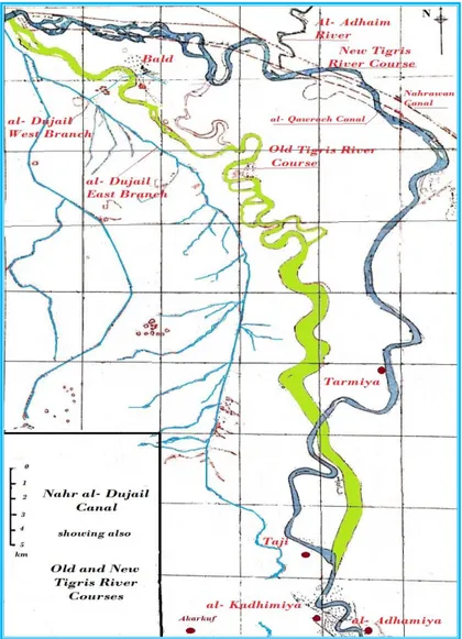
In an exceptional case, one important irrigation system remained functioning during these difficult times. This was Nahr al- Dujail and its network. In fact, Nahr Dujail had dated long time before the building of Sammara by Khalifah al- Mu’tasim. It was located on the right bank of the Tigris River and irrigated the land west of the Tigris in the districts extending from Balad, not that far downstream from Samarra, down to the northern quarters of western Baghdad. Its intake was on the right bank of the Tigris River about 10 kilometers northwest of Balad and seven kilometers south east of al- Qadisiyya fort, close to the old town called al- Alath, refer back to Figure 76.
The construction of the canal is believed to be one of the works of the Sassanid King Kosrow Anushirwan, who at the same time had dug the al- Qawrach canal on the left bank of the Tigris to replace Nahr al- Qaim, which fed the Nahrawn Canal, (see Paper 9). The water level of the Tigris was raised during summer by constructing a stone weir across the Tigris to feed Nahr al- Qawrach and Nahr Dujail together with many other smaller canals.
Nahr al- Dujail ran for five kilometers to the south down from its intake before it divided into two branches. The southwesterly branch had previously continued on its course and irrigated the lands to the left of River Euphrates until it disappeared close to the modern Saqlawiya canal which off takes from the Euphrates fourteen kilometers north of Falluja, but at the Abbasid time, this branch was already abandoned.
The second branch flowed southward and was called during the Abbasid period by Nahr Batatiya, which headed towards a small town known until recent times by the name of Sumayka, which took later on the name of Dujail. In those days Nahr Batatiya irrigated the districts north of Baghdad known as Tusuj Maskin and then
Tusuj Katrabbul before it entered the northern district of western Baghdad known as al- Harbbiyyah quarter where it became part of the canal network supplying the city and irrigated it by its numerous watercourses which it gave there.
Ibn Serapion described Nahr al- Dujail in his manuscript “Description of Mesopotamia and Baghdad” which he wrote about the year 900 AD, translated, and edited by LeStrange, where he described in section (V) Nahr al- Dujail as:
“a canal which was taken from the Tigris River; its beginning was a league or two more above the village of Ar-Aabb., which then it passed cross-wise, and from it branched many canals that watered the domains of Maskin and Katrabull, and the hamlets pertaining thereto, and finally it poured into the Tigris between ‘Akbara and Baghdad.
In section (XIL) of the same manuscript, Ibn Serapion gave more details on the canal system, which supplied al- Harbbiyyah quarter.He specifically mentioned the Nahr Batatiya branch that was brought from the Dujail and had its origin at six leagues below the head of the Nahr Dujail itself after watering many domains and villages it went by the midst of the district Maskin and flowed out to the northern quarters of Baghdad; He went on to say;
“From the Batatiya canal many branches were taken off, The first one branched at a point below the Bridge of- Boats , flowed then through the conduit of the Kuraj at the Bridge of the Gate of Anbar and ran then passing along the
road of al- Kabish where it disappeared. The second branch was taken from the main Batatiya canal at a point below the
offtake of the first branch and ran into the city and passed over the Trench of Tahir by an aqueduct called ‘Abbarat al- Kukh to continue afterwards down the road of Dujail towards the Quadrangle of the Persian (Murabba‘at al- Furs) and here it gave a tertiary branch which continued under the name of Nahr al- Dukkan- al- Ibna to disappear afterwards further down.
The main canal, however, after skirting the Quadrangle of the Persians reached to the Bridge of Abu- I- Jwan, and at this point it gave a third branch which headed towards the place of the Scribe for Orphans, and thence to the Quadrangle called Murabba‘at Shabib where it poured out into the canal of the road near the Syrian Gate.
As the main canal continued from Bridge of Abu- I- Jwan it reached the Palace (Kasr) Hani and after passing it ran to the garden called Bustan al- Kass, and finally poured out into the canal which had passed down to the road of the Kataba’s” [28].
During the thirteen century, the Tigris River flooded many times. Some of these floods were exceptionally severe, the high flows caused much destruction along its banks, and it is believed that the floods of 1225 and 1242 could have been behind the change of the Tigris River course from its original course to an easterly one where it remained there until the present days, see Figure77. However, this had also caused marked changes on the landscape and the irrigation systems, which had served the area.
Hadhera, and ‘Akbara in the western side of the new course, whereas they were on the eastern side of the original course before. This event caused in depriving these towns from their original water supply and led Khalifah al-‘Mustansir (1226-1242) to relocate the intake of Nahr- Al- Dujail upstream from its original intake to a point south of Istablat opposite to al-Qadisiyya, see Figure 76, and at the same time he opened many new branch canals to supply these towns. Moreover, he enlarged the Batatiya branch and increased its flow to take care of the newly added requirements.
Figure 77: Map showing Nahr al- Dujail and its two branches, the old course of the Tigris River (green) before it changed in the thirteen century to the present day’s course (blue). Moreover, the location of the modern town of Balad, the two modern districts of Bagdad, al- Kadhimiah and al- Adhamiya
In the fourteen century Nahr Dujail was mentioned by the famous Muslim scholar and explorer Ibn Battuta (1304- 1369) in his book of travels; where he stated that when he decided to visit Mosul and Diar Bakr further north, he took the caravan from Baghdad which followed the Dujail canal from its end at Harbiyah quarter. He reported that the caravan followed the road alongside the canal which, as he said, was derived from the Tigris and watered a large number of villages, which were located in a wide and fertile tract.
Ibn Battuta went on to say that after two days of riding, they arrived to a large village that was called (Harbi) in the district of Maskin where the caravan made a stop. It took them another two days to reach close to the Ma‘ashuk (al Ashiq) fort opposite to Samarra on the other side of the river [29].
Nahr al- Dujail survived the events that followed the fall of Baghdad in 1258 and the wide spread intentional destruction of the canal networks in the aftermath on the hands of the Mongols. Nevertheless, the fact remains that these networks had already suffered at that time from considerable deterioration and damage since the days after Khalifah al- Mutawakkil.
Nahr Dujail continued to serve its purpose until the 1960s when it was replaced by a modern canal system that expanded the original irrigated area considerably. This new system is known today as the Ishaqi Irrigation Project, borrowing the name from the old Ishaqi Canal which is not related to it. The head regulator of the present project is incorporated in the modern Samarra Barrage completed in 1956, which serves irrigation and power generation purposes but above all saving Baghdad from the Tigris River destructive floods by diverting these floods to the Tharthar depression.
References
[1] Ibn Rusteh, Ibn Omar, A. (1892). Kitab Al Boldan. Edited by De Goeje M.J. p.255. Bibliotheca Geographorum Arabiccotum, M. J, Brill .
https://www.dopdfwn.com/cacnoscana/scanoanya/kutubpdfcafe-NTCB.pdf [2] Al- Mas’udi A. A. (2005). The Meadows of Gold and Mines of Gems. In
Arabic edited by Kammal Hassan Mar‘ie. Vol.4, p.45. Published by al-Maktabat al-‘Assria, Beirut.
ص عبارلا ءزجلا رهوجلا نداعمو بهذلا جورم يلع نب نيسحلا نب نسحلا يبأ : يدوعسملا 45 https://ia600801.us.archive.org/14/items/JASIMSMARTHDD_GMAIL_201 71009_1020/%D9%85%D8%B1%D9%88%D8%AC%20%D8%A7%D9%8 4%D8%B0%D9%87%D8%A8%20%D9%84%D9%84%D9%85%D8%B3% D8%B9%D9%88%D8%AF%D9%8A%20%D8%A7%D9%84%D8%AC%D 8%B2%D8%A1%20%D8%A7%D9%84%D8%B1%D8%A7%D8%A8%D8 %B9.pdf
[3] Wikipedia (2019). Al- Mu’tasi”. The page last edited on 17 February 2019. Visited on 25 February 2019.
https://en.wikipedia.org/wiki/Al-Mu%27tasim#Formation_of_the_Turkish_guard
[4] Al- Ya’qubi, Ibn Wadih. (2018). The Geography; Kitab al-Buldan. The English Translation, edited by; Matthew S. Gordon, Chase F. Robinson, Everett K. Rowson and Michael Fishbein, pp.87-98. Leiden, Boston.
https://archive.org/details/TarikhAlYaqubi?q=al+hira+and+its+histories+phil ip+wood
[5] Northedge, A. (2007). The Historical Topography of Samarra. Samarra Studies 1, British School of Archeology in Iraq, Foundation Max Von Berchem. http://www.bisi.ac.uk/sites/bisi.localhost/files/Northedge_Historical_Topogra phy_of_Samarra_I.pdf
[6] Sossa, A. (1949). Irrigation of Sammara. In Arabic, Volume I, Chapter 1, pp.79-87. Al Ma‘arif Press, Baghdad .
ص لولاا لصفلا لولاا ءزجلا ءارماس ير : دمحأ :هسوس 79 87 https://archive.org/details/nasrat_1_201901
[7] Al Hamawi, Y. M’ujam al- Buldan. In Arabic, Vol 4, article 9672, p.405. Edited by Farid A Al Jundi Dar Al Kutub Al Elmiya, Beirut.
ص عبارلا لصفلا "نادلبلا مجعم" توقاي : يومحلا 405
هرقفلا 9672
https://ia600804.us.archive.org/8/items/FP73901/04_73904.pdf [8] Northedge, A. and Kennet, D. (2003). The Archeology of Samarra.
Updated on 5th August 2003.
http://community.dur.ac.uk/derek.kennet/samarra.htm
[9] [Republic of Iraq. Samarra: Archeological Site (2006). Executive
Summary-Nomination Document for inscription on World Heritage list January 2006. file:///C:/Users/HP/Documents/276rev-1456-Nomination%20Text-en.pdf [10] Amin, A. J. M. Employment of the Turk Soldiers in the reign of Khilafa al-
ةيسابعلأ ةلودلا خيرأت يف تارضاحم" دمحم هعمج ملاسلا دبع : نيمأ –
يف كارتلاا دنجلا مادختسأ
"مصتعملأ دهع http://cedh.tu.edu.iq/hd/images/16-ilovepdf-compressed.pdf
[11] Northedge, A. and Kennet, D. (2003). The Archeological Survey of Samarra: History of Samarra. Last updated 05/08/2003. Web Page accessed on 10th
December 2018. http://community.dur.ac.uk/derek.kennet/samarra.htm
[12] Ibn Faqeh, A. (1996). Kitab al- Buldan, What was said on Samarra. In Arabic, p.374. Edited by Yousif al Hadi Alam Al Kutub Publishers, Beirut.
ص نادلبلا باتك : قحسأ نب دمحم نب دمحأ الله دبع يبأ :)هيقفلا نبأب بقلملا( يتادمهلا 374
https://ia800500.us.archive.org/21/items/Boldan_Faqeh/Boldan.pdf
[13] Al-Ali S.A. (2001). Samarra: Study of the Emergence and Population Structure. (Arabic) P111, Printing and Distribution Publication Company, Beirut.
ءارماس : دمحأ حلاص :يلعلا ص ةيناكسلا ةئيبلاو ةأشنلا يف ةسارد 111 https://ia902807.us.archive.org/28/items/sameraa/%D8%B3%D8%A7%D9% 85%D8%B1%D8%A7%D8%A1%20%D8%AF%D8%B1%D8%A7%D8%B 3%D8%A9%20%D9%81%D9%8A%20%D8%A7%D9%84%D9%86%D8% B4%D8%A3%D8%A9%20%D9%88%20%D8%A7%D9%84%D8%A8%D9 %86%D9%8A%D8%A9%20%D8%A7%D9%84%D8%B3%DA%A9%D8% A7%D9%86%D9%8A%D8%A9%20-%20%D8%B5%D8%A7%D9%84%D8%AD%20%D8%A3%D8%AD%D9 %85%D8%AF%20%D8%A7%D9%84%D8%B9%D9%84%D9%8A.pdf [14] Al Jahidh, Omar ibn Uthman. (1966). Kitab al-Haywan (the Book of Animals).
In Arabic, Book 1, Vol 4, p.422, 2nd edition edited by Abdul Salam Mohamed Harun. Printed and Published by Maktabat Mustafa al Babi al Halabi.
ص عبارلا دلجملا ناويحلا باتك : رحب نب نامثع يبأ :ظحاجلا 422
https://ia902907.us.archive.org/13/items/FPhiwanhiwan/hiwan4.pdf
[15] Al Khatib, M. (2011). The garden - Collection of Fine Literature and Eloquent Wisdom. In Arabic, Vol 2, p.293. 2nd edition edited by Suleiman bn Salih al Karachi. Published by Maktabat Al Salafiya,Cairo and Dar Al Asima, al Riyadh.
ص لولاا دلجملا ةغيلب ةمكحو عراب بدأ ةعومجم ةقيدحلا باتك , نيدلا بحم :بيطخلا 293
https://archive.org/details/7DeeQH
[16] Al- Ya’qubi, Ibn Wadih. (2018). The Geography; Kitab al-Buldan, The English Translation, Edited by; Matthew S. Gordon, Chase F. Robinson, Everett K. Rowson and Michael Fishbein, p.99. Leiden, Boston. https://archive.org/details/TarikhAlYaqubi?q=al+hira+and+its
+histories+philip+wood
[17] Al ‘Amid, T M. (1968). Abbasid Samarra’s: Architecture in the reign of al- Mutawakkil. In Arabic translated from English, Chapter 4, pp.204- 205, PhD thesis “The Abbasid Architecture of Samarra during the reign of al- Mu’tasim and al- Mutawakkil”. Submitted to Edinburgh University.
ةيبرعلا ةغللا ىلا مجرتم عوضوملا( لكوتملا دهع يف ةيسابعلا ةرامعلا . رفظم رهاط :ديمعلا ةيسابعلا ءارماسأ " هموسوملا هاروتكدل ةحورطأ نم عبارلا لصفلا نم
ص 205 -204
http://www.abualsoof.com/INP/Upload/Books/Al-Abbasieh-Building.pdf [18] Rebstock, U. (2008). Weights and Measures in Islam. Helaine Selin
(Hrsg.): Encyclopedia of the history of Science, technology, medicine in the non- western cultures. Springer, Berlin.
https://www.academia.edu/26399908/Weights_and_Measures_in_Islam [19] The History of al-Yaʿqubi. Edited by; Matthew S. Gordon, Chase F. Robinson,
Everett K. Rowson and Michael Fishbein, pp.93- 94, 96, 98, 99. Leiden, Brill, Boston.
https://archive.org/details/TarikhAlYaqubi?q=al+hira+and+its+histories+phil ip+wood
[20] Al- Ya’qubi, Ibn Wadih (2018). The Geography; Kitab al-Buldan. The English Translation. Edited by; Matthew S. Gordon, Chase F. Robinson, Everett K. Rowson and Michael Fishbein, pp.93, 96, 99 Leiden, Brill, Boston. https://archive.org/details/TarikhAlYaqubi?q=al+hira+and+its+histories+phil ip+wood
[21] Northedge, A. (2007). The Historical Topography of Samarra. Samarra Studies 1, pp.80, 88-90 British School of Archeology in Iraq, Foundation Max Von Berchem.
http://www.bisi.ac.uk/sites/bisi.localhost/files/Northedge_Historical_Topogra phy_of_Samarra_I.pdf
[22] Al Hubaytti, S. M. (2005). Description of the Residences of the Caliph al – Mutawakkil Ala- Allah in al – Buhturi’s Poetry. In Arabic, Journal of the college of basic education, University of Mosul, Vol 2, No2.
صخو هطامنأ يرتحبلا رعش يف الله ىلع لكوتملا ةفيلخلا روصق فصو" دومحم هرهاس :يطيبحلا "هصئا
https://www.iasj.net/iasj?func=fulltext&aId=7589
[23] Al Hamawi Y. M’ujam al- Buldan. In Arabic, Vol 3, article 6202, p.195. Edited by Farid A Al Jundi Dar Al Kutub Al Elmiya, Beirut.
هرقفلا ثلاثلا لصفلا "نادلبلا مجعم" توقاي : يومحلا 6202
ص 195
https://ia800804.us.archive.org/8/items/FP73901/03_73903.pdf
[24] Al Hamawi Y. M’ujam al- Buldan. In Arabic, Vol 2, article 3143, p.166. Edited by Farid A Al Jundi Dar Al Kutub Al Elmiya, Beirut.
ةرقفلا يناثلا لصفلا "نادلبلا مجعم" توقاي : يومحلا 3143
ص 166
https://ia800804.us.archive.org/8/items/FP73901/02_73902.pdf
[25] Al- Ali, S .A. (2001). Samarra: Study of the Emergence and Population Structure. In Arabic, pp.131-132. Printing and Distribution Publication Company, Beirut. ءارماس : دمحأ حلاص :يلعلا ص ةيناكسلا ةئيبلاو ةأشنلا يف ةسارد 131 -132 https://ia902807.us.archive.org/28/items/sameraa/%D8%B3%D8%A7%D9% 85%D8%B1%D8%A7%D8%A1%20%D8%AF%D8%B1%D8%A7%D8%B 3%D8%A9%20%D9%81%D9%8A%20%D8%A7%D9%84%D9%86%D8% B4%D8%A3%D8%A9%20%D9%88%20%D8%A7%D9%84%D8%A8%D9 %86%D9%8A%D8%A9%20%D8%A7%D9%84%D8%B3%DA%A9%D8%
A7%D9%86%D9%8A%D8%A9%20-%20%D8%B5%D8%A7%D9%84%D8%AD%20%D8%A3%D8%AD%D9 %85%D8%AF%20%D8%A7%D9%84%D8%B9%D9%84%D9%8A.pdf [26] Ali, A. (1889). A Short History of the Saracens. Chapter XIX, pp.264-288,
Macmillan and Co Ltd, London, 1854 edition. https://ia801600.us.archive.org/2/items/in.ernet.dli.2015.279429/2015.27942 9.A-Short.pdf
[27] Al Zahrani, Dh. Y. (1988). The fiscal deficit in the Abbasid state. Its causes and the methods used for treating it. In Arabic, Um al- Qura University, Journal Year 1, No 2, pp.197-245, AH 1409. ىلولاا ةنسلا ىرقلا مأ ةعماج ةلجم "ةيسابعلا ةلودلا يف يلاملا زجعلا" ىحي نب الله فيض :ينارهزلا ددعلا 2 ص 197 -245 http://www.mediafire.com/file/tznjtivx54m/0205-%D8%A7%D9%84%D8%B9%D8%AC%D8%B2+%D8%A7%D9%84%D9 %85%D8%A7%D9%84%D9%8A+%D9%81%D9%8A+%D8%A7%D9%84 %D8%AF%D9%88%D9%84%D8%A9+%D8%A7%D9%84%D8%B9%D8 %A8%D8%A7%D8%B3%D9%8A%D8%A9.pdf
[28] Le Strange, G. (1885). Description of Mesopotamia and Baghdad, written about the year 900 A by Ibn Serapion. The Journal of the Royal Asiatic Society of Great Britain and Ireland, Parts 1 & 2, pp.1-76, 254- 315, London.
https://archive.org/details/DescriptionOfMesopotamiaAndBaghdadWrittenA boutTheYear900ByIbn/page/n3
[29] Gibb, H. A. R. (1959). The Travels of Ibn Battuta AD1325- 1354. The Halkuyt society second series, CXVIII, Vol 2, p.346, The University Press, Cambridge, Cambridge. (on line version), Second Series CXVII Cambridge, the University Press (on line digital version).
https://books.google.se/books?id=dS4rDwAAQBAJ&pg=PA346&lpg=PA34
6&dq=dujail+canal&source=bl&ots=HvxLgLBacs&sig=ACfU3U2v-FYQXTTCC1xtjPLerf9mcXgoyg&hl=en&sa=X&ved=2ahUKEwjb_rOXrIb hAhXqAhAIHe0hCqMQ6AEwBHoECAUQAQ#v=onepage&q=dujail%20c anal&f=false
![Figure 67: Nahr al-Ishaqi canal course, modified from reference [6].](https://thumb-eu.123doks.com/thumbv2/5dokorg/4300650.96246/7.813.109.709.201.963/figure-nahr-al-ishaqi-canal-course-modified-reference.webp)
![Figure 69: Overall view of al- Ashiq palace showing the Tigris River in the background [8]](https://thumb-eu.123doks.com/thumbv2/5dokorg/4300650.96246/9.813.170.649.128.401/figure-overall-ashiq-palace-showing-tigris-river-background.webp)
![Figure 70: Istablat Camp site south of Samarra [9].](https://thumb-eu.123doks.com/thumbv2/5dokorg/4300650.96246/10.813.172.643.105.645/figure-istablat-camp-site-south-samarra.webp)