Scientific Press International Limited
Agriculture and Irrigation of Al-Sawad during the
Early Islamic Period and Baghdad Irrigation:
The Booming Period
Nasrat Adamo1 and Nadhir Al-Ansari2Abstract
As time progressed Iraq witnessed the transfer of power from the hands of the Umayyad dynasty in Syria to the Abbasids who established their State in Iraq. The following developments are detailed. During these days very little had happened with respect to land ownership, the question of Kharaj tax and even the agrarian relations between property owners, private farmers and the general peasantry. It may be assumed therefore, that at the start of the Abbasids period all the irrigation networks and infra structures were in good working conditions, and that all the required work force was available as the case had been in the Sassanid and Umayyad periods. The Abbasids may be credited for keeping the vast canal network of al-Sawad in good working conditions and they knew well that the major source of their revenue came from agriculture. Full description of the major canals, which had supplied the lands between the Tigris and Euphrates Rivers. The five main canals or arteries were all fed from the Euphrates and flowed in south easterly direction towards the Tigris where they poured; so naturally they were used for navigation between the two rivers in addition to irrigating all the lands here by vast networks of distributaries and branch canals and watercourses. The major part of these systems was inherited from the Sassanids and the Babylonians but they were kept in good working conditions all these centuries by good management and maintenance. These five major canals according to their sequence from upstream to downstream were called during the Islamic era as, Nahr al-Dujail off taking from the Euphrates at a short distance above Anbar, followed by Nahr Isa, Nahr Sarsar, Nahr al- Malik, and finally Nahr Kutha. The Euphrates River itself bifurcated at its downstream reach to two branches whereby its eastern branch irrigated in its turn a very extensive tract of land in the southern part of al- Sawad with a complex system
1 Consultant Engineer, Norrköping, Sweden.
2 Lulea University of Technology, Lulea, Sweden.
Article Info: Received: February 10, 2020. Revised: February 15, 2020.
of branches and tributaries. In following each of these canals great deal of details are given on the agriculture of the various districts and the towns they had served, their flourishing conditions and the prosperity they had enjoyed. Khalifah al- Mansour built the new capital of the Abbasid State, Baghdad at the heart of the Sawad region. There was a vast system of watercourses which served Baghdad and its environ that had originated mostly from Nahr Isa is also treated not failing at the same time to describe even the minute details of the various quarters of the city and the markets they had served, which were all based on the writings of contemporary Scholars. The long and deep trench called as the Shabour Trench, which had extended from Hit on the Euphrates down to nearly the Persian Gulf was given its share of detailing as it stood some waterworks, which was meant for defense rather than irrigation. This stream was carrying the major share of flow of the Euphrates during the Abbasids period before it ended indirectly into the Batyiha. It gave however very large branch from its right hand side before reaching the site of Babylon which was called Nahr Nil. This important canal flowed in southeasterly direction and poured at the end in the Tigris in the same fashion as the previous canals did and similarly spreading irrigation watercourses all the way down.
1. Agriculture and Irrigation of Al-Sawad
The rivalry between the Umayyads and other Muslim factions over the right to the
Khilafa had never ebbed during the Umayyads dynasty reign (661- 750 AD). The
other contenders were the Shiites of Ali, who believed that the Khilafa should belong to the descendants of Ali ibn Abi Talib, the fourth Khalifah after the death of the Prophet Mohammad, and his cousin and son in law. Others were the Abbasids that believed that the right heirs to the Khilafa were the descendants of Al Abass ibn
Abi Talib the uncle of the Prophet. The Abbasids rose in rebellion against the Umayyads after building coalition with the Shiites and the other disgruntled groups
that were mainly the “Mawalis”, as the Umayyads called the Persians and the eastern Arabs, who were treated differently from Syrian Arabs.
Rebellion erupted in Khurasan in Persia led by Abu Muslim Al Khurasani, who fought the Umayyads and defeated them and occupied Maru, the capital of
Khurasan, and established the Abbasid Khilafa there. From Maru, the head of the
rebellion, Abul Al-Abbas as-Saffah moved to Kufa in August 742 AD, but he remained in hiding till October 750, when he was declared as the Khalifah of the
Muslims. Final defeat of the Umayyads army came just afterwards in the battle of
Zab in the north of Iraq located between Mosul and Erbil. The Abbasids then completed the conquest of the whole of Iraq followed by Bilad al Sham and Egypt.
Abul Al-Abbas As-Saffah captured Damascus in the meantime and slaughtered the
remaining members of the Umayyads family to the last one except for, Abd
al-Rahman the great grandson of Khalifah Abdul Malik, who escaped to Spain and
continued the Umayyads dynasty rule there. By this Abul Al Abbas earned the title
As-Saffah which is the synonym to “Slaughterer”, and he became the first Abbasid Khalifah and the twentieth Khalifah of the Muslims after the Prophet Mohammad,
but his rule only lasted from 750 to 754 AD.
After establishing himself as Khalifah, Abul Al- Abbas moved from Kufah and took a new residence in Hashimiyah, then moved to Anbar where he died. As it had happened before after upheavals and political troubles, the system of land cultivation and irrigation in Al- Sawad did not suffer much change during this period for the simple reason that most of the cultivation and maintenance works were done by the Nabathaeans (Lakhmids). Those were the non-Muslim populations that were already there even before the Muslim conquest and who were from Aramaic origin, and also by the Zanj slaves working for the Muslim landlords who had owned possessions of agricultural lands after the Islamic conquest.
The Lakhmids had previously worked either for the Persian landlords, or had owned the lands themselves. In such case, the land was left to them by the Muslims as per the conditions of the peace agreement (Sulh) on account of their peaceful surrender to the Muslims at the onset of the conquest and conditioned by paying the required (Kharaj) and (al- Jizyah) taxes. Muslims after the conquest interfered very little with the agrarian organization and left it as it was in the previous days of the
Sassanids, and even added some reforms, which improved the conditions as far as
During the Persian era, each village had a chief called (Dahkan) to which all the peasantry in the village would answer to, and would work for. As the time progressed, Muslim land owners gradually started to appear and the role of the
Dihkans changed gradually to tax collection[1]. This arrangement made the
continuation of cultivation of the land possible during these transitional periods. Moreover, new lands were reclaimed during the reign of the first four Khalifahs, and similarly during the days of the Umayyads. This was a direct result of the establishment of the new Islamic cities of Basra, Kufah and Wasit, and the adoption of the (qati’a) land ownership system, which encouraged private investment in constructing new irrigation projects.
It may be assumed therefore, that at the beginning of the Abbasid period all the irrigation networks and farm structures were in good working conditions, and that all the required work force was available as all these were left to them from the late
Sassanid and Umayyads periods.
After confiscating the lands that belonged to the Umayyads and their followers, the
Abbasids carried out tax collections on all cultivated lands in the same way as the Umayyads had done before to finance their new established Khilafa State. The Kharaj money collection and its spending were the duty of Diwan Al Kharaj (the
treasury). The collected Kharaj was normally spent to pay salaries of the army and the various officials and administrators of the government, and also on the construction and maintenance of public works, in addition to covering the lavish spending on the Khalifah’s household and building of new great palaces and even new cities such as Baghdad and Sammara.
Diwan Al- Kharaj had always allocated sizable amounts of money to take care of;
irrigation works maintenance, and improved agriculture and even took steps to help farmers by supplying them with seeds, oxen for tillage and the services of engineers and experts in water supply matters, and helping them with loans [2].
It was clear that the vitality and existence of the Khilafa State depended on al-
Kharaj money, which was derived from cultivating the vast land of al- Sawad and
to a lesser extent from the other parts of the state. During the Abbasid era, and even before that, irrigated agriculture was practiced all over al- Sawad districts while rain fed agriculture was the common method of irrigation in the al- Jazira area, north of al- Sawad, which extended from Mosul and upwards in the lands between the two rivers. Irrigation from springs and qanãt or karez was also common in the foothills areas of al- Jazira east of the Tigris River. Gravity irrigation, however, was also practiced in al- Jazira on the banks of the Euphrates and especially in the Khabour tributary districts where agriculture was flourishing and fields and plantations were very dense.
Much writing has come to us from the 9th and 10th centuries, which were considered as the golden period of the Abbasid era. These writings were from Muslim scholars and geographers, who wrote their accounts on the various aspects of life of the Abbasid Khilafa at that time, which included also their narrations on agriculture and irrigation in addition to describing the newly built cities of Baghdad and Samarra. The map of Iraq in Figure 49 shows the locations of the five Islamic
cities, Basrah, Kufah, Wasit, Baghdad and Sammara, which were all built in Iraq during the Islamic period up to and including the Abbasid period.
Around these cities, the irrigation systems and cultivated lands were outspread and covered the whole of al- Sawad in one continuous green carpet of lush plantations and fields. The same map shows also the main roads leading to other regions, and it indicates the Great Swamp (Al- Bataih) that was formed after the famous 628/629 flood of the two rivers, in addition to, the change of the course of the Tigris river after that flood [3].
The irrigation networks of al Sawad described by the Muslim scholars and geographer were already in existence before the Abbasids and the Umayyads, and a great deal of these canals had survived since the Babylonian times under different names. Some other canals were constructed by the Sassanids, who made a grand job of this work, helped by the fertility of the delta. Changes had occurred, however, on these networks during this long time due to the changing courses of the Tigris and Euphrates Rivers after great floods. Nevertheless, the full potential of the land was realized most of the time. It is therefore, natural to refer to the writings of those Muslim Scholars when anyone attempts to learn more on the al- Sawad geography and its human and agricultural environment during the Muslim era.
Such writers, who may be described as eyewitnesses very close of major events, were many, and we can mention famous names. These are; Iskharti (Died in 957 AD), al- Ya’qubi (Died in 879 AD), ibn Hawqal (943- 988 AD), al- Maqdasi (946- 991 AD), ibn Jubayr (1145- 1216 AD), ibn al- Mustawfi (1169- 1239), Yaqui al-
Hamawi (1179- 1229 AD), and ibn Batuta (1304- 13 69 AD).
The writings of these scholars give vivid descriptions and rich accounts of the various parts of this region during the Abbasid period, and reported especially the great extent of irrigation works that supported agriculture there. Istakhri for example, wrote on the dense palm tree gardens around Basrah and along its canals. He went on to say that the palm trees’ gardens had extended for a distance of fifty
farsakh from a small village called Abdasi at the north east of the great swamp
(Batihah) to Basrah and then down to Abadan; he also mentioned the palm trees’ plantations along the Ubullacanalwhich extended for a distance of four farsakh. In his description of its beauty, he thought of it as being one of the four earthly heavens, while not missing at the same time to mention the other palm trees’ groves on the banks of Ma’kilcanal.
The irrigation system of Basrah canals, as were described, had a unique property; since most of the canals were supplied by water twice every twenty four hours when the tide of the Gulf would raise the water level in Shatt al Arab and would fill these canals with water, so all the fields and the palm groves were irrigated automatically. Other writings such as those by al- Maqdasi mentioned that rice was grown in the shallow parts of the great swamp (Al Bataih) and its periphery, which extended up and close to Wasit, in addition to the dry patches of land within the swamp itself.
Wasit itself, by the same account, was very rich in palms groves, gardens and
extensive rich fields. In following more of these writings, we come to the description of Kufah by Ibn Jubayr, who wrote that the eastern bank of the
Euphrates River in Kufah had dense groves of all sorts of fruit trees, and in the western bank of the Euphrates, farms and tree groves extended as far as al- Hirra and al- Qadisiyah on the edge of the desert.
Istakhri again wrote that all the lands between Baghdad at the north and Kufah in
the south, and from Dujaela, the new course of the Tigris after the flood of 629 AD, in the east to the Euphrates in the west, all the land was so crowded with farms and cultivations that it was not possible to distinguish between the different farms, and it was also crowded with towns and villages as well.
All these writers agreed that agriculture had flourished and prospered because of the extensive irrigation canal networks not only in lower al- Sawad but also in the areas of Baghdad and Samarra and to the east from the Tigris River as far as Hulwan in the foothills of Persia.
To describe the waterworks and irrigation canals that crisscrossed al-Sawad from north to south, the course of the Euphrates will be followed from where it enters the delta to where it ends in Al- Bataih. The same procedure will also be followed for the Tigris River but not failing at the same time to mention that a great deal of the information on these waterworks are obtained from the writings of ibn Serapion and other contemporary authors.
A great deal of these information were compiled and commented upon in G LeStrange book “The land of the Eastern Caliphate” which was published in 1905
[4]. The book was based on LeStrange’s translation of the Arabic MS which is kept
now in the British Museum Library which was written by Ibn Serapion, a Syriac author and physician, who lived in the second half of the 9th century, and described Mesopotamia and Baghdad. Moreover, this MS. included references to the writings of many of the Muslim scholars, and geographers mentioned previously, who themselves were contemporary with that period.
Figure 49: Map of Iraq during the Abbasid time. The map shows the important cities and roads at that time, it also shows the Tigris and Euphrates and Al -Bataih. The map is taken from the book ‘Twin Rivers” by
Seton Lloyd [3]. Many other details are removed by the from the original map by the writer for the sake of clarity.
A straight line carried from the Tigris at Tikrit to the Euphrates would cross the river a little below Anah, where its course makes a great bend, and this is the natural
frontier between Jazira and al-Sawad, as marked by ibn al-Mustawfi. To the south of this line begins al-Sawad, or the alluvial land, while to the north lie more stony plains of Upper Mesopotamia. The city of Haditha on the Euphrates, about 35 miles below Anah, is the northernmost town on this side, which Yakut had described as possessing a strong castle surrounded by the waters of the Euphrates, and it was founded during the Khilafa of ‘Umer not long after the Muslim conquest.
Downstream of Haditha the town of Hit is reached, which Yakut referred to as a small ancient town that still existed. Ibn Hawkal spoke of Hit as a very populous town, and Ibn al-Mustawfi in the 13th century described that more than 30 villages were around Hit. He mentioned the immense quantities of fruit, both of the cold and the hot regions, which were grown here; nuts, dates, oranges and egg-plant all ripening freely, but not pleasant to live in on account of the overpowering stench of the neighboring bitumen springs. From the Euphrates at Hit ran the famous trench that was excavated by the Persian King Shapur II (309- 379 AD) whom the Muslims called (Shabour Dhu- l- Aktaf), meaning (Shapur with the broad shoulders), and according to Arabic literature the trench was also called (Khandak Shapur). Sousa, a contemporary Iraqi engineer and historian, casts doubts on the originator of this trench, and claims that its digging may be attributed either to the Babylonian king Nebuchadnezzar (605 –562 BC), or the Persian King Khosrau I Anushirvan, who reigned during (531-579 AD). Sousa, however, does not produce any evidence to support this claim. He also quotes Sir William Willcocks, the British engineer who had studied the irrigation of Iraq in the beginning of the twenties century of saying that “he had traced the remains of this canal, and it branched from the Euphrates seventeen kilometers south of Hit” [5].
The trench ran all the way down to reach the Gulf at Ubulla (near Basrah). Originally, it carried water and it was intended as a line of defense for the rich lands of Lower Mesopotamia against the desert tribes.
Our opinion on this issue, however, is; thatthe trench may have been a prehistoric course of the Euphrates and not a man-made channel, and that it may have been modified for defense purposes. This opinion is reached on account of its huge magnitude and the long distance it traversed down to the Gulf, in addition to the usual historic trend of the Euphrates and Tigris of frequently changing their courses throughout history as they enter the delta region.
Next on the course of the Euphrates was the city of al- Anbar “the granaries” standing on the left bank of the river. It was one of the large cities of Iraq in Abbasid times, and it had dated before the Muslim conquest. It was called “the granaries” because the Persian kings had stored the wheat, barley and hay for the rations of their troops in the city. The first Abbasid Khalifah Abul Al- Abbas as-Saffah, had for a time made Anbar his residence, and he died in the palace which he had built here. His brother and successor Abo Jafar al-Mansur lived also for a short time at Anbar, and from here he moved to Baghdad; the new city he built and made it the new capital of the Islamic Khilafa.
At the time of building Baghdad there had been already one large canal, which branched from the Euphrates at a point about twelve leagues (58km) downstream
from Hit. This canal was called (Dujail Canal) which should not be confused with the other Dujail canal that branched from the right bank of the Tigris near Tikrit, which ran all the way down to reach Baghdad itself.
By the close of the 10th Century, and according to Iskharti, this Euphrates- Dujail canal had already silted up in its uppermost portion so the remaining lower reach ceased to receive water from the Euphrates. This had required the digging of a short channel taken from the Tigris- Dujail to connect to the lower reach of the
Euphrates- Dujail in order to continue the irrigation of the district called Maskin
north of Baghdad and cover the needs of the Harbiyah Quarter, the northern districts of western Baghdad in the same way that the Euphrates- Dujail was doing before.
Going down further south the next canal branching from the Euphrates was the grand Nahr –Isa Canal that had its intake at a little distance downstream from Dujail
Canal offtake and flowed in a parallel course in the direction of Baghdad. These
two canals provided Baghdad and surrounding fields, farmlands and date- palm groves with abundant water supply, as will be explained in details later on.
The round city of Baghdad which was the original core of western Baghdad, was built by Khalifah al-Mansur in (762–767AD) as the official residence of the
Abbasid court. The significance of the site of the new city was in the availability of
abundant water and the decrease of the dangers of flooding. This in turn led to the expansion of the city and increased its influence. Providing a bridge across the Tigris River here had provided a good link with the left side of the river and continued communication with the eastern parts of al- Sawad all the way to Hulwan in Persia. The Tigris penetrated the city and divided it into two parts Karkh (western part) and ar-Rusafa (eastern part) [6].
The original round city had three concentric walls, and an outer deep moat filled with water, four equidistant gateways being left in each of the circuits of the walls. These were, Basrah gate (SE), the Kufah gate (SW), the Khurasan gate (NE), and
the Syrian gate (NW). The first two of these gates opened on the Sarat canal, which
branched from Nahr Isa, while the third gate, which was on the Tigris led to the main bridge of boats; and the last led to the high road to Anbar on the Euphrates. Unlike the Greek, Roman, and Sassanid kings, who named cities after themselves,
al-Mansur chose the name Dar al-Salam or “Abode of peace,” a name alluding
Paradise. Furthermore, he did not object to the use of the ancient city name
“Baghdad,” although many people used to call it the city of Al-Mansour.
The city gained later on many more appellations, including al-Mudawara, meaning around city, because of its circular form, and al-Zawarh, meaning the winding city, because of its location on the winding banks of the Tigris. But one of the main
reasons of getting the city its present name was that Abo Jafar al-Mansur had built
the city in the location of the village which was known as (Baghdad) since the days of Hammurabi.
The name “Bjaddada” appeared on a clay tablet dating back to the eighteenth century BC, and in days of King Hammurabi “Baghdadi” was the name of the same place which appeared on another clay tablet dating back to (1341- 1316 BC). On
another tablet the name “Bjaddado” again appeared in a historical document from 728 BC during the reign of the Assyrian king Tglat Flasar III of (727- 745 BC). The location of the city was of very high strategic value being right at the center of Mesopotamia. It was therefore, a meeting place for caravan routes on the roads to
Khurasan and Bilad Al-Sham (Syria). It had a system of canals that provided water for cultivation and could be used as ramparts for the city; moreover, it also had adequate drinking water supply for the people and provided an environment more or less free of malaria [7].
These considerations must have contributed to the choice of this site as explained by LeStrange in the following statement:
“The new capital would then stand in the center of a fruitful country, not on the desert border, as was the case with Kufah and the neighboring towns, for the barren sands of Arabia come right up to the bank of the Euphrates. By a system of canals, the waters of the latter river were used to thoroughly irrigate and fertilize all the country laying between the two great systems, and while the waters of the Tigris were kept in reserve for the lands on the left Persian bank; and thus the whole province, from the Arabian Desert on one side to the mountains of Kurdistan on the other, was to be brought under cultivation and converted to a veritable garden of plenty. Lastly, the Lower Tigris before its junction with the Euphrates was more practical for navigation than this latter river, inasmuch as the great irrigation canals, by effecting drainage of the surplus waters of the Euphrates into the Tigris, scoured the lower course of this river, and kept the waterway clear through the dangerous shallows of the Great Swamp immediately above Basrah estuary [4].
Nahr Isa, which in addition to its abundant water was at the same time the first
navigable canal from the Euphrates to the Tigris. So the town of Anbar gained more importance due to the fact that it was laid in its position on the head of the first navigable canal that flowed from the Euphrates to the Tigris, which it entered at the harbor (Al-Fardah) in Baghdad. Nahr Isa took its name from an Abbasid prince,
Isa, who was either Isa ibn Musa, a nephew of al- Mansur, or Isa ibn Ali (the more
usual ascription), the uncle of al- Mansur. In either case, Prince Isa gave the canal its name; he has re-dug it, had also enlarged it, making it thus a navigable canal from the Euphrates into Baghdad.
The canal was excavated originally during the Sassanid era for irrigation purposes only, and some sources mention that its original name was Tabik Kisrawi, and that it was dug by a Persian whose name was Babik ibn Bihram ibn Babik [8].
Where the canal had left the Euphrates, a short distance below Anbar, it was crossed by a bridge called (Kantara Dimmima), near the village of the same name, close to the hamlet of al- Fallujah, then it came after some distance to the town of al-
Muhawwal, one league (about 4.8 kilometers) distance from the suburbs of west
Baghdad. At this point, an important canal branched from the left side of the Nahr
Isa; which was called the Nahr Sarat.
Another important canal branched from the right side of Nahr Isa about one mile below the al-Muhawwal town, which was the Karkhaya canal. According to the description of Ibn Serapion, the Karkhaya canal was great loop canal supplying
water to the other secondary canals that traversed the Karkh district of west Baghdad, and it is said to have been dug at the time of the foundation of Baghdad by Isa (the uncle of the Khalifah). The canal, after giving five branches from the left side and one from the right, discharged its remainder back into Nahr Isa canal. The five left-hand branches just mentioned were supplying the various quarters of the city and they were called Nahr Razin or Nahr Attab in its lower course, Nahr Bazzazin (Canal of Cloth- merchants), Nahr- ad- Dajjaj (the fowls’ canal), and Nahr- Kilab (the canal of dogs). The sixth branch which took its water from the right side was called Nahr- al Kallayin (the canal of Cooks who sold fried meat) [9].
In its upper reach, Karkhaya canal was a broad canal that needed to be crossed by arched stone bridges (Kantarah), the lower branch canals, and the watercourses of
al-‘Amud and the Tabik were evidently much smaller water courses, since no such
bridges were needed for the high roads to cross them. Many more watercourses were then dug within west Baghdad for its water supply system; dykes and reservoirs were built and even drains to drain the swamps around Baghdad, freeing the city of malaria [10].
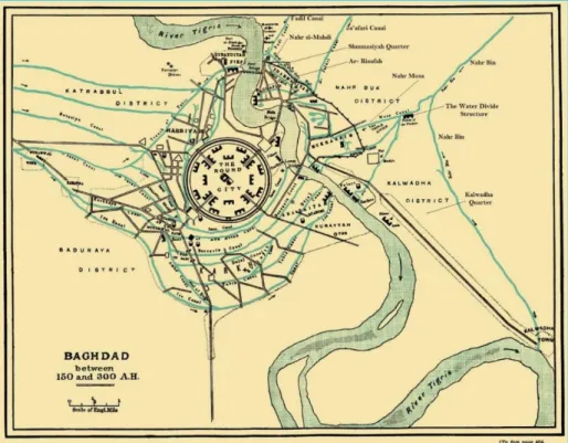
It may be said therefore, that water for irrigation and municipal use for the Karkh area (western Baghdad outside the round city), was supplied from the canals which branched from the Euphrates, and only some parts in the northern edge of the city were supplied from the Tigris. A clear idea of the density of these canals may be obtained by referring to Figure 50.
Now if we go, back to Nahr Sarat canal which was already mentioned, which branched from Nahr Isa upstream from al- Muhawwal; this canal formed along its course the dividing line between Katrabull district to the north and Baduraya to the south of the west Baghdad area. Generally, it ran south of Nahr Isa and parallel to it and after one league (about four kilometers) from its off- take it bifurcated into two branches. The left branch was called Khandaq Al- Tahir (Trench of al-Tahir), which after a short distance fed another canal on the right side called the Little Sarat, which finally, after watering the adjacent district, poured back in the main Sarat
Canal.
Both the streams of Nahr Isa and the Nahr Sarat poured their remaining water back into the Tigris immediately below the Basrah Gate in two separate ports, which were the Upper Fardah and the Lower Fardah. The map in Figure 51 shows the canal networks serving both western and eastern quarters of Baghdad.
Figure 51: Baghdad map showing in addition to west Bagdad the Easter Quarters and the canal network serving both. East Baghdad Quarters were
served from branch canals originating from Nahrawn Canal [8], [9]. Iskharti noted in his accounts on Nahr Isa and Nahr Sarat, that while barges could
pass freely down Nahr Isa`s canal all the way from the Euphrates to the Tigris, the
Sarat, on account of its weirs, dams, and waterwheels, was not navigable for large
boats.
The Arabic word al- Muhawwal signified the place where bales are “unloaded,” and so the town at this place appears to have received this name from the unloading of the river barges which took place here. Therefore, the cargo was carried over to the small boats that piled on the Sarat and Karkhaya in the reaches between the weirs. Furthermore, it would appear that these weirs kept the waters of the Karkhaya and its secondary canals to higher levels relative to the stream that flowed down the main Sarat Canal. As we have already seen a branch from the Karkhaya was carried across and above the Sarat by the arches of the aqueduct of a bridge, passing thence
northward into the Harbiyah Quarter. The contemporary writers made a special mention that the waters of the Nahr Isa
never failed, nor was its channel was liable to become silted up. They describe it as flowing through the midst of the city, reaching the Tigris at the lower harbor. The arrangement of transferring the cargo at al- Muhawwal made of this town a very busy commercial station, and an important node on the canal system serving Baghdad and its suburbs. The town was a fine town, famous for its markets and its
gardens, and as late as the 14th century possessed some significant buildings. The
exact site of al- Muhawwal is not known, but it must lie to the north-east of the ancient Babylonian mound called the Hill of “Akarkuf,” which is frequently mentioned by the Arab geographers [4].
Dealing with the question of drinking water supply of Baghdad, al-Tabari quoted other writers of how things were going about in solving this matter. LeStrange confirmed al- Tabaris’s account, whereby water was carried, in the beginning, on the backs of the pack- mules filled in leather bags of goatskin and delivered to the population and even to al- Mansur palace. Later on al- Mansur commissioned his uncle ‘Abd- as Samad, to lay a conduit to bring water direct from outside the
Khurasan Gate to the palace tanks.
This work ‘Abd- as Samad successfully accomplished, making the conduits of teak wood (Saj), and the Khalifah improved on this by digging permanent watercourses from both the Dujail Canal and the Karkhaya Canal thus bringing a plentiful supply of water into the palace and other parts of the Round City. The beds of these new watercourses were laid in cement, and they were arched over throughout their whole length with burnt bricks set in mortar, so that during both summer and winter water never failed in any street or quarter in the city of al-Mansour.
Development of many new quarters around the Round City occurred rapidly after the construction of the city itself and the density of population in these new residential and commercial parts increased also, especially after al- Mansour had ordered the removal of the markets to Karkh outside the Round City. This led to the construction of the large network of canals and watercourses such as to penetrate to all the living quarters and groves in Karkh [4]. [9]. Unfortunately, we have not
received any account from the geographers and scholars who wrote on Baghdad telling us exactly which of these canals and watercourses were used to supply drinking water and irrigation water, and which of them were drains to remove the surplus water from the other watercourses. It is not possible that one canal can perform the dual functions and this will remain obscure unless some new findings would explain this matter [11].
Baghdad, soon after its establishment, and as usual for lively and prosperous cities grew in population and built up area, so it extended to occupy the left bank of the Tigris after al- Mansur had established there an encampment for the troops of his
son al- Mahdi, and built a large palace for him and large Mosque. This new quarter
was named ar-Rusafah, which was surrounded by a wall for its defense. This work opened the way for many influential people to build palaces, and for other people to build their homes and establish many markets (Suqs). The water supply to the eastern side of the city, however, was obtained from the Tigris River through tributaries of the Grand Nahrawn Canal, which originated from the Tigris River eastern bank downstream from Tikrit at the upper edge of al-Sawad. (More details on this canal, its tributaries and the dense canal network which supplied all the area east of the Tigris River, including east Baghdad will be discussed in details in the next paper, but the map already shown in Figure 51 indicates those tributaries feeding east Baghdad in addition to the other network which were serving west
Baghdad.
Now Leaving Baghdad and its dense network of channels and watercourses, and continuing down along the Euphrates, we come to the third large transverse canal called Nahr Sarsar.
This canal branched from the Euphrates at a point three leagues (about 15.5 km) below the village Dimmima already mentioned. Its course was in the direction towards the Tigris in a similar fashion as the other canals, and also poured into it at a point four leagues (19.2km) above Madain which was located on the opposite bank. According to Sousa, the course of Nahr Sarsar at that time was in the same direction that is followed by modern days Abu Gharib canal [5].
Nahr Sarsar canal, in its lower reach, crossed the Baduraya district which was south
of west Bagdad. Ibn Serapion described the numerous waterwheels (daliyas) and levers (Shadufs) which were set up along its banks for irrigating the fields and orchards. This gives clear indications that the irrigated land in that part was higher than the canal water level. At a point some distance above Zariran, which was almost in sight of the white palace of Khusraw at Madain, this canal, poured out into the Tigris.
The flourishing town of Sarsar from which the canal took its name was located where the great bridge of boats carrying the Kufah road crossed the canal, and the town was about two leagues (about 10 km) only from Karkh, the southern suburb of west Baghdad. The canal as described by ibn Hawkal was navigable for boats, and the town stood in a forest of date-palms [4]. According to the same scholar he
described the land of al- Sawad between Baghdad and Kufah; that it was crisscrossed by multitude of canals, and watercourses, which were fed from the Euphrates in such a way that it was difficult to distinguish these canals one from the other and the land that was served by Nahr Sarsar canal was no exception [5].
Following the same pattern of branching from the Euphrates, the next transverse canal was Nahr al– Malik, which began at the village of Falluja five leagues (24 km) below the head of Nahr Sarsar Canal and flowed into the Tigris three leagues (about 14 km) below Madain. Nahr al– Malik, or the “King Canal,” actually had existed from the times of the Chaldeans of Babylon or even before that and was specifically mentioned by the Greek historian Herodotus. On this canal he had said:
“Nahr Malcha; it is the largest Babylonian canal which ran to the east and could be navigated through by large ships”.
This description and other historian’s accounts show clearly that it belonged to the
Chaldeans era of Babylon. Referring back to the description of the hydraulic works
of the great Chaldean king Nebuchadnezzar given in Paper 5, the following was stated:
“He excavated four canals across the land, to unite the Tigris and Euphrates.
The width and depth of each canal were enough to carry merchant ships, and branching into a network of smaller canals and ditches for irrigating the fields. In order to fully control the increased mass of waters which he thus obtained, Nebuchadnezzar had created a huge basin or reservoir near Sippar on the left bank of the Euphrates by flooding the present day depression of Akarkuf, which was
according to the description of Herodotus some thirty- five miles in circumference and as many feet in depth, even though, other writers gave higher figures. Water was supplied to the reservoir by a very large canal which had existed already or re-excavated by Nebuchadnezzar. Stored water in the reservoir during flooding season was released to the Euphrates in the low water season. This canal was called “Nahr Malka” or the Kings River”.
This means that not only Nahr Malik was dug by the Chaldeans but all the other canals already described belonged to the Chaldean era” [12].
Yakut reported that tradition gave it that Nahr al– Malik as having been dug either
by King Solomon or by Alexander the Great. The remnants of this canal are currently observed close to the present day al- Radhwaniya canal according to Sousa
[13].
On the banks of this canal the town called Nahr al–Malik was located, seven miles south of Sarsar, and according to Ibn Hawkal, the town was a large and fine town, being, likewise, famous for its corn and palm groves. Mustawfi added to this that over 300 villages were of its district.
Nahr al–Malik town which was also called (Daskarah) was about five leagues (24
km) west of Baghdad, it was on the bank of Nahr al–Malik from which it took the name. It was dated to the pre Islamic era, and it was populated afterwards by Muslims and the Persians and Jews who had lived here before but converted to Islam after the conquest during the reign of Khalifah ‘Umar. Nahr- al Malik town or Daskarah was famous for its great wealth derived from agriculture and animal husbandry, so the population worked either in farming and breeding cattle and sheep, or were traders exporting the surplus of all their products to other towns and villages. In one story attributed to Yakut, he had mentioned a man called Dabes ibn Sadaka as being such an important and wealthy trader and Dahkan, who had ordered his men to herd more than hundred thousand of his animals, presumably to be sold elsewhere. During the Abbasid times, this area was also used as hunting place by the Khalifes due to the abundant game that took a refuge in its thick groves [14].
The next major transverse canal, which was supplied by the Euphrates, was the Nahr
Kutha, which had its intake at a point three leagues (about 15 km) below the head
of Nahr al-Malik, and it poured into the Tigris ten leagues (48 km) below Madain. The Kutha canal watered the district of the same name, which was also known as the Ardashir Babgan district, after the first Sassanid king (224-242 AD), though part of it was counted as the Nahr Jawbar district, which was watered from a canal branched from Nahr al-Malik.
On the banks of this canal stood the city of Kutha Rabba, with its bridge of boats, it was described by the 10th century Ibn Hawkal as a double city, Kutha at-Tarik
and Kutha Rabba; and he claimed that the last was a city larger than Babylon. The first archaeologist to examine the site was George Rawlinson (1812–1902) who had uncovered a clay tablet of king Nebuchadnezzar II of the Chaldean Empire mentioning the city of Kutha. Today the site of Kutha is marked by a 1.2 kilometer long crescent shaped main mound with a smaller mound to the west. The two mounds, as typical in the region, are separated by the dry bed of an ancient canal,
and this site is called nowadays the Tell Ibrahim. The site was dug again in (1881) by the Iraqi archeologist and scholar Hormuzd Rassam (1826-1910) for four weeks but little was discovered; mainly some inscribed bowls and a few tablets [15], [16].
A littleto north of Kutha Canal stood the large village of Al- Farashah. On the half way stage between Baghdad and Hilla. Ibn Jubayr, who was here in (1184 AD), described it as the populous well-watered village, where there was a great caravanserai for travelers, defended by battlemented walls, and Mustawfi also gave
Farashah in his itinerary, placing it seven leagues (about 35 km) south of Sarsar.
The excavation of Kutha Canal and the other aforementioned canals are attributed to the great Chaldean king Nebuchadnezzar according to the Greek historian
Xenophone who described them as;
“being as wide as a hundred feet, and as so deep that they carry even corn
ships, and for the construction of canals palm trees had to be felled all along their rout” [17].
Therefore, the whole area served by Kutha Canal was well developed much before the Abbasid time, and even earlier than the Persian era. The continued habitation and cultivation of the land for such a long period is a clear sign of its fertility and the continuous mention of it in historical document is another indication of this important fact.
Below the Kutha Canal, at the lower Euphrates region, irrigation canals had a different pattern of spreading than those in the middle Euphrates, for these canals had to adapt to the continually changing river course, which was characteristic of this alluvial river here during history. The topography of the land between the Tigris and Euphrates had also its impact on having some of the major canals flowing into the swamps south of Kufah, rather than the Tigris, which was the case of the Kutha Canal and other major canals already, described.
The Euphrates River course had experienced many changes during history and one of the works of Alexander the Great during his stay in Babylon was solving the problem of the Pallacopas (described in paper 6). This was to enhance the flood routing conditions of the Euphrates and solve the problem of the reduced water level in Babil River on which Babylon was located (Shatt al- Hillah of today). The
Pallacopas however, had developed at a later stage into the major branch of the
Euphrates (Shatt al- Hindiyah) on which Kufah was built just after the Islamic conquest.The same thing was experienced at the late years of the 19th century so it prompted the Ottoman Government to construct the Hindiyah barrage to solve the problem which had resulted in reducing the flow in the other branch (Shatt al- Hilla). This government had enlisted the service of the well-known British engineer, Sir William Willcocks, who designed and oversaw the construction of the well-known Hindiya Barrage which was completed then in 1913 [18].
In the 10th century, however, the twoEuphrates branchesbifurcated at a point some six leagues (29 km) below where the Kutha Canal was led off. The western main branch, to the right, or the Kufah branch, presumably the old Pallacopas, passed down to Kufah poured hence into the Great Swamp in the manner that was meant to be in the Alexander’s works,whilst the eastern branch, to the left, was called by
Ibn Serapion and the other Arab geographers, as the Nahr Sura. This is the Shatt al-
Hillah of today and the Babil River as it was called during the Alexander time. From the upper reach of Nahr Sura canal, many areas were watered directly. These were the districts of Sura, Bisama and Barbisama, which formed parts of the middle
Bih Kubadh district, then in continuing southwards the canal passed a couple of
miles westwards of the city called Kasr Ibn Hubayrah. Here it was crossed by a great bridge of boats known as the Jisr Sura or (Suran) by which the pilgrim road went down from Kasr Ibn Hubayrah to Kufah. The town of Al Kasr, as it was called for short, meaning the Castel or Palace of Ibn Hubayrah, took the name, from its founder, who had been governor of Iraq under the Umayyad Khalifah Marwan II. Later on the first Abbasid Khalifah al- Saffah took up his residence here for a short time and called it Hashimiyah in honor of his own ancestor Abu Hashim, before he moved to Anbar. The Khalifah al-Mansur was also said to have resided in
Hashimiyah before he moved to Anbar then to Baghdad, which he had built. In the
10th century, Kasr ibn Hubayrah or Hashimiyah was the largest town between
Baghdad and Kufah, and it stood on a loop canal from the Sura, called “Nahr Abu
Raha” or “Canal of Mill.”
At a point above Babil, the Surat Canal gave a large branch which flowed towards the Tigris and irrigated large tract of fertile land, and it was called the Nahr Nil
Canal or the Shatt- al- Nile of today. Ibn Serapion, however, had called this canal
in his writings as the “Great Sarat,” which should not be confused with the “Sarat
Canal”, the other canal which irrigated Baghdad and mentioned earlier. It may be
added that Nahr Nil waterway was the last of the group of canals, which emptied in the Tigris, and we shall discuss more of it after we follow the course of the main
Surat Canal itself.
So the Surat Canal, after it gave water to Nahr Nil it continued in its course southwards and passed by the ruins of Babylon on its left, and then after few miles passed through the city of Hilla “the Settlement”, which was called then “Al-
Jami’an” or the “two mosques”.
This town was a populous place, and its lands were extremely fertile. The town itself was built on the right bank by Sayf- ad- Dawlah, chief of Bani Mazyad, in about 1102 AD before it extended to the left side also. The city as geographers described it was surrounded by date palms groves and hence had a damp climate, and that it had quickly grown in importance, as it was located on the road from Baghdad to
Kufah. As the Surat Canal continued down from al- Jami’an (Hilla) for another six
leagues (29km) and according to Ibn Serapion it bifurcated. The main right arm going south was kept the name of the main canal Sura, while the left arm was called
Nahr an-Nars, which turned off to the south- east, this after watering “Hammam ‘Umar” and other villages reached the town of Niffar. This canal took its name from Nars (or Narses), the Sassanid king who came to the thrown in 292 AD. Both the Sura Canal and Nahr an- Nars poured their waters afterwards into Badat Canal,
which traversed the north limit of the great swamp. The Badat Canal was a drainage canal which branched from the left bank of Kufah arm at a point one day journey north from Kufah, probably near the town of Al- Kanatir.
Nevertheless, going back to the Nahr an-Nil, the main branch of Surat, which was mentioned in the beginning; this branch continued to serve its purpose up to the present days under the name of Shatt- Nil. From its point of origin the Nahr
an-Nil Canal or the “Great Sarat” flowed eastwards past many rich villages, throwing
off numerous water channels and shortly before reaching the city of al-Nil, a loop canal, the Sarat Jamasp, branched from its left and rejoined the main stream below the town.
This loop canal had been re-dug by Hajjaj, the famous governor of Iraq during the
Umayyad Khilafa, who was also the founder of the town itself, but the loop canal
took its name, from Jamasp, the chief fire priest, who in ancient days had aided
Gushtaps to establish the religion of Zoroaster in Persia.
After watering all the surrounding districts, Nahr an-Nil Canal came to a place called “al- Hawl” which was the lagoon near the Tigris opposite Nu’maniya where a branch called Upper Zab branched from its left side and poured its water into the Tigris. But the main course of Nahr an-Nil turned here to the south and flowed for some distance parallel to the Tigris down to a point one league (about 5 km) below the town of Sabus which lay one day’s march above Wasit. Here the canal finally discharged its waters into the Tigris. The lower reach of the Nahr an- Nil was known as the Nahr Sabus in reference to the town of Sabus, although some geographers had called this reach as the “Lower Zab.” Yakut in the 13th century reported that
both canals had, however, gone much to ruin, thoughtheybordered fertile lands [19].
From the foregoing, we learn that most of the al-Sawad, between the two rivers, even from ancient times, was irrigated mainly from the Euphrates. The ancient people of Mesopotamia made use of the flat topography of the land and its slope from the Euphrates in a southeastern direction towards the Tigris.
The Tigris in this whole reach acted as a drain; the only exception was south of Kut where the land below it sloped in southwestern direction. In this way, the major canals of the Euphrates were the arteries of the intensive canal networks that covered every piece of land in lower Sawad between the two rivers.
The Tigris River, however, was mainly the source of water for irrigating the lands on its left side as far as the foothills of Persia. The Irrigation of this vast tract of land which extended from downstream of Tikrit to Kut was done by the Great
Nahrawn Canal in addition to the Adhaim and Diyala Rivers which were acting in
interaction with the Nahrawn Canal by irrigating lands above the Nahrawn canal course. Other canals from the Tigris; the Dujail and Ishaqi, also played an important role by irrigating the districts north of Baghdad directly from the Tigris. These canals and their related hydraulic works hydraulic works are discussed in paper 9 and paper 10.
The great canal systems were kept in good working condition to a late date during the Abbasid Khilafa. This was only possible as a result of the Persians, Umayyads and the Abbasids attention which they had paid to them. They knew very well that these canals were the source of most of the revenue on which their empire`s livelihood depended; as without them agriculture could not flourish and give the abundance they had managed to have.
The land of Mesopotamia that was also called al- Sawad, as seen from historical
records and archeological discoveries, was densely populated. Babylon, Seleucia
Ctesiphon, Basrah, Kufa, Wasit, Bagdad and Sammara, were the large cities and
capitals of Mesopotamia during its long history, and so they were the centers of trade and wealth of the successive empires that had dominated this land at their times. The main rivers and the network of canals supplied these cities with their needs of water. In the case Basrah and partially of Baghdad, dug canals supplemented the drinking water supply that was drawn from the rivers. Fortunately, the many manuscripts left to us by the scholars and geographers, Muslim and others, are rich in the description and details of agriculture and irrigation throughout the ancient times and Islamic era.
The Arabic manuscripts describing Basrah and Baghdad canals and the other major canal networks of both Euphrates and Tigris were translated to English by western scholars since the late nineteen century and were published in the Journals of the Royal Asiatic Society of Great Britain and Ireland and the Royal geographical Society of London, and even in large volumes of books were written by travelers who inspected the remnants and ruins of these canals and provided great deal of details shedding light on these great works. One very important example, which is worth referring to, is the translation of ibn Serapion MS which was done and commented upon by LeStrange and published in (1895) [20].
References
[1] Al Douri, Abdul Aziz (1995). The Economic History of Iraq in the fourth Hijri century. (In Arabic) Center of the Arab Unity Studies Third Edition; Beirut 1995 pp. 203- 208. ا يرودل : دبع ا خيرأت : زيزعل ا قارعل ا يف يداصتقلا ا نرقل ا تاسارد زكرم .يرجهلا عبارل ا هدحول ا . هيبرعل ا توريب هثلاثلا هعبطل 1995 https://archive.org/details/6789054_20171015
[2] Zahrani, D Y. (1986). Expenditures and their Management in the Abbasid state. (Arabic). Mecca 1986.
فيض الله ا : ينارهزل : الله فيض يف اهترادأو تاقفنلا" ا "هيسابعلأ هلودل . ةبتكم ا بلاطل ا هكم .يعماجل ا همركمل – ا .هيزيزعل 1406 هيرجه 1986 هيدلايم http://www.mediafire.com/file/x3n5cuxyfy5wpr3/%D8%A7%D9%84%D9 %86%D9%81%D9%82%D8%A7%D8%AA+%D9%88%D8%A5%D8%AF %D8%A7%D8%B1%D8%AA%D9%87%D8%A7+%D9%81%D9%8A+% D8%A7%D9%84%D8%AF%D9%88%D9%84%D8%A9+%D8%A7%D9% 84%D8%B9%D8%A8%D8%A7%D8%B3%D9%8A%D8%A9.pdf
[3] Seton, L. (1943). The Twin Rivers. Oxford University Press.
https://ia801609.us.archive.org/6/items/in.ernet.dli.2015.61071/2015.61071.T he-Twin-Rivers.pdf
[4] Le Strange, G. (1905). The land of the Eastern Caliphate. Cambridge
Geographical Series Cambridge University Press, pp. 1-24. https://archive.org/details/landsofeasternca00lest/page/n7
[5] Sousa, A. (1986). History of The Civilization of Al Rafidyan Valley in the Light of archeological findings, historical sources. In Arabic, pp. 231- 232 Chapter 13, Baghdad. https://ia601507.us.archive.org/8/items/nasrat_201901/%D8%A7%D9%84% D9%81%D8%B5%D9%84%20%D8%A7%D9%84%D8%AB%D8%A7%D 9%84%D8%AB%20%D8%B9%D8%B4%D8%B1%20%D8%A7%D9%84 %D8%B9%D8%B5%D8%B1%20%D8%A7%D9%84%D8%B9%D8%B1% D8%A8%D9%8A%20%D8%A7%D9%84%D8%A7%D8%B3%D9%84%D 8%A7%D9%85.pdf
[6] University of Baghdad (2018). History of Baghdad. Baghdad University web
site. Web page accessed on 2018-12-10. http://en.uobaghdad.edu.iq/?page_id=15089
[7] Al Qazaz, A. (2018). Baghdad. Encyclopedia.com. Website accessed on 2018-12-10.
https://www.encyclopedia.com/places/asia/iraq-political-geography/baghdad
[8] Al- Tabari, A J. History of the Prophets and Kings. In Arabic, Vol. 7, p.620, article 3/280 Second Edition Published by Dar Al Ma’aarif Egypt.
ا خيرات " . ريرج دمحم رفعج يبأ : يربطل ا و لسرل ا قيقحت."كولمل وبا دمحم ا ميهاربأ لضفل ا دلجملا عباسل ص 620 ةرقفلا 3 / 280 ، ا هعبطل ا رصم راد ، هيناثل ا رصم ،فراعمل https://archive.org/details/Tarikh_Tabari
[9] Le Strange, G. (1900). Baghdad during the Abbasid Caliphate. The Clarindon Press, Oxford.
https://ia802609.us.archive.org/9/items/BaghdadDuringTheAbbasidCaliphate FromContemporaryArabicAndPersian/LeStrange_Baghdad_Abbasid.pdf [10] Global Security Organization (2018). Abbasid Caliphate. Web Site entered
on 2018-12-10. https://www.globalsecurity.org/military/world/iraq/caliph-abbasid.htm
[11] Raouf, E A. ( 1979). History of old drinking water projects in Baghdad. In Arabic. Al Mawrid Magazine. Special Issue Vol. 8, Issue 4, p.165. Ministry of Culture and Information. Dar Al Jahiz. Baghdad.
عيراشم" . ملاسل دبع دامع:فوؤر ا برشل ا ةلجم ."دادغب يف هميدقل ا ،)صاخ ددع( درومل ا دلجمل ا ،نماثل ا ددعل ا ص عبارل 165 ةرازو ، ا و هفاقثل ا راد . ملاعلا ا ظحاجل . دادغب 1979 https://archive.org/stream/almawred8-4-1979#page/n1/mode/1up
[12] Ragozin A. Z. (1903). Media, Babylonia, Persia. Published by G P Putman’s Son, pp. 225-226, London.
https://archive.org/stream/mediababylonand00ragogoog#page/n11/mode/2up [13] Sossa, A. (1986). History of The Civilization of Al Rafidyan Valley in the
Light of archeological findings, historical sources. In Arabic, Chapter 11, pp. 154- 156 Baghdad 1986. https://ia601508.us.archive.org/12/items/nasrat_20190531/%D8%AD%D8% B6%D8%A7%D8%B1%D8%A9%20%D9%88%D8%A7%D8%AF%D9%8 A%20%D8%A7%D9%84%D8%B1%D8%A7%D9%81%D8%AF%D9%8A %D9%86%20%D8%A7%D9%84%D9%81%D8%B5%D9%84%20%D8%A 7%D9%84%D8%AD%D8%A7%D8%AF%D9%8A%20%D8%B9%D8%B4 %D8%B1%20%D8%A7%D9%84%D9%83%D9%84%D8%AF%D8%A7% D9%86%D9%8A%D9%88%D9%86.pdf
[14] Al Nidawy Kh., T. (2017). The village of King’s River Daskarah and its economic and cultural impact from the date of the liberation to the year 656 after Hijra. In Arabic, al-Farahidi literature magazine, No 29, pp. 82-105.
ا اهرثاو كلملا رهن ةركسد ةيرق :حيرف يويلع يكرت دلاخ :يوادنل ىتح ريرحتلا نم يفاقثلاو يداصتقلاا 656 دعب ا .تيركت ةعماج بادلال يديهارفلا ةيلك ةلجم."هرجهل ا ددعل 29 ص 82 -105 راذأ . 2017 https://www.iasj.net/iasj?func=fulltext&aId=142485
[15] Fandom (2018). Kutha. Religion Wiki. Website visited on 2018-12-11. http://religion.wikia.com/wiki/Kutha
[16] Rassam, H. (1987). Asshur and the Land of Namrod. Curts and Jennings. https://ia902909.us.archive.org/29/items/asshurlandofnimr00rass/asshurlando fnimr00rass.pdf
[17] Duncker, M. and Abbot, E. (1879). The History of antiquity. Vol. III, Chapter XV, pp. 359-360, London.
https://ia802606.us.archive.org/22/items/historyantiquit06duncgoog/historya ntiquit06duncgoog.pdf
[18] Willcocks, W. (1917). Irrigation of Mesopotamia. E. & F. N. SPON, pp. xviii- xix, 2nd edition.
https://www.europeana.eu/portal/en/record/9200143/BibliographicResource_ 2000069327903.html
[19] Le Strange, G. (1905). The land of the Eastern Caliphate. Cambridge
Geographical Series, pp. 72- 74, Cambridge University Press. https://archive.org/details/landsofeasternca00lest/page/n7
[20] Le Strange, G.(1895). Description of Mesopotamia and Baghdad written about the year 900 A.D. by Ibn Serapion. The Journal of the Royal Asiatic Society of Great Britain and Ireland, London.
https://archive.org/details/DescriptionOfMesopotamiaAndBaghdadWrittenA boutTheYear900ByIbn

![Figure 50: Canals and Watercourses of Karkh neighboring suburbs [9].](https://thumb-eu.123doks.com/thumbv2/5dokorg/4300466.96237/12.813.83.734.107.543/figure-canals-watercourses-karkh-neighboring-suburbs.webp)