Biodiversity and habitat conditions in
reaches with high flow velocity along
gradients in hydrological and
geomorphological alteration
A study of six rivers in Sweden
Anders Aalto
Master thesis in Ecology, 30 hp. Master’s Program in Ecology, 180 hp.
Abstract
The vast majority of rivers in the developed world are affected by human alteration, which in turn negatively affects the species that rely on these highly diverse and species rich areas to survive. Homogenization of previously heterogenic areas due to a change in water discharge and the substrate availability in the rivers is often regarded as the main reason for the loss of species richness in rivers and the riparian zone. Because of this, there are a lot of restoration projects which main goal is to increase heterogeneity. The goal of this thesis is to compare hydrology and geomorphology variables between four types of reaches with high flow velocity (rapids in free-flowing reaches, rapids with regulated flow, impounded reaches and reaches in outlet channels below hydropower plants). In this thesis I wanted to find out how changes in geomorphology and hydrology affect fish species richness, riparian vegetation richness and aquatic vascular plants species richness. The result show that both fish species richness and riparian vegetation species richness are negatively affected by the changes in geomorphology and hydrology. There was no significant difference for aquatic vascular plants when
comparing the regulation types. The most altered reach type, outlet channels, had
significantly fewer fish species compared to the less altered reach type, impounded reaches. Outlet channels also had less riparian vegetation cover compared to all other regulation types, and fewer riparian vegetation species compared to both free-flowing reaches and impounded reaches. In conclusion, hydropower plants and timber floating have both
negatively impacted the riverine ecosystem, and in turn caused a decrease in species richness for fish and riparian plants. The reaches studied in this thesis will continue to be altered and the species richness and species composition will change from an ecosystem that relied on the natural flow regime to an ecosystem more used to the flow regime created by the hydropower plants.
Table of contents
1 Introduction ...1
1.1 Aims and hypothesis ... 3
2 Methods ... 4
2.1 Study areas... 4
3 Results ... 8
4 Discussion ... 24
4.1 Geomorphology ... 24
4.2 Hydrology ...25
4.3 Biological variables ... 26
4.4 Conclusion ... 28
5 Acknowledgements ... 29
6 References ... 30
1
1 Introduction
Rivers are often seen as a continuum of ecological communities gradually changing from the source down to its mouth, and in between these two points there are numerous processes that affects the species that rely on rivers and their riparian zones for habitat (Aarts et al. 2004; Vannote et al. 1980). Due to these processes and their longitudinal variation, the river and the riparian zone around the river are considered as one of the most complex and biodiverse ecosystems in the world (Dynesius and Nilsson 1994). The species inhabiting riverine and riparian ecosystems rely on fluvial geomorphic processes that transport essential nutrients and substrates downstream. The changes in the hydrological cycle over the year also plays an important role for the species, and different species rely on specific events occurring during specific periods of the year when the discharge or water levels are suitable for them (Palmer et al. 2010; Vannote et al. 1980; Vinson and Hawkins 1998)
In a natural river unaffected by humans, the channel bed and riparian zones of river system usually contains a large diversity of sediment deposits that have been created over a long period of time, which in turn creates opportunities of species to occupy different niches and survive in the habitats. Natural rivers, unimpacted by humans, are therefore areas with high habitat heterogeneity. The importance of habitat heterogeneity for biodiversity is well known, and there have been several studies that show that the general biodiversity of a freshwater habitat increases when there is a larger variety of substrates in the habitat (Palmer et al. 2010; Tews et al. 2004; Vinson and Hawkins 1998; Ward et al. 1999). In this report, this difference in substrate diversity between habitats will be referred to as structural complexity, and areas with less substrate diversity are therefore less heterogeneous. In regulated rivers, the natural deposition of sediments is highly altered. The dams created for hydropower will act as a barrier for sediments, trapping it upstream, which greatly reduces the amount of sediment deposition into the downstream reaches and the riparian zones (Brandt 2000). Hence, the trapping of sediments upstream will reduce the structural complexity of habitats in downstream reaches and riparian zones, and negatively impact the species reliant on the sediment deposition to create their habitats.
One species that is negatively affected by the reduction in sediment deposition is brown trout (Salmo trutta), which relies on sediment deposition for creation of their spawning grounds. There are also riparian species that rely on nutrients from the sediment deposition during flood events (Dynesius and Nilsson 1994; Lepori et al. 2005). Species in the riparian zone and aquatic plants that require the sediments and nutrients that the flood events transport
downstream will also be negatively impacted by the trapping of sediments upstream, leading to a decrease in population size (Bunn and Arthington 2002; Dynesius and Nilsson 1994; Lepori et al. 2005; Palm et al. 2010).
Over 70% of the water discharge in the 139 largest rivers in North America, Europe and Russia are affected by human alteration, which leads to fragmentation of the river and alteration of flow regimes (Dynesius and Nilsson 1994). The most common alteration is the building of hydropower plants and the dams that are required to sustain them. Hydropower plants and dams have an impact on ecosystems in riverine environments in several ways (Bednarek 2001). Dams act as unnatural barriers, fragmenting the ecosystem, which impedes organisms travelling downstream and upstream to reach their habitats (Drinkwater and Frank 1994). Dams also alter the natural flow regime of a riverine ecosystem. Rivers with hydropower have had the flow regime altered to match the energy needs required by humans. This can lead to that the highest flow is during the winter when the energy need is the highest for humans (Renöfält et al. 2010). Such changes in the natural flow regime will have a large impact on most species groups living in the riverine ecosystem and the riparian zone. For example, the unnatural timing for flow release can have an impact on growth cues for fish
2
and provide cues for migration (Petts 1984). The loss of large floods and the decrease in flood duration will also negatively impact the aquatic plants and riparian plants. Habitats that were previously flooded during the flood event will no longer become flooded, leading to
desiccation. There are aquatic plants and riparian plants that are reliant on the flood events for dispersal of seeds and pollen downstream. Without these flood events the population of these species that require flood events for seed dispersal will be reduced (Bunn and
Arthington 2002).
In northern Europe, timber floating was crucial to commercial forestry in providing the infrastructure to bring logs to saw and pulp mills and ports for export before the development of roads and trucks allowed road transport (Törnlund and Österlund 2002). This timber floating has also affected most rivers and the riparian zone by removing large boulders, straightening the river channel, and removing side channels. The removed boulders were usually placed in the riparian zone, decreasing the habitat availability in the riparian zone. Hence, timber floating has negatively impacted riverine and riparian ecosystems by
decreasing habitat heterogeneity, which in turn decrease the number of species that can live in these ecosystems (Nilsson et al. 2005).
The homogenization of previously structurally complex lotic environments and riparian zones due to human influences could explain the observed decline in fish populations and other decreases in biodiversity in the lotic habitats and riparian zone. To combat this loss of biodiversity, restoration projects all around the world have been initiated, with the primary goal to increase the structural complexity and habitat availability of the systems (Elosegi et al. 2010; Palm et al. 2010). These restoration projects vary in size, ranging from only restoring the structural complexity by reintroducing larger substrates such as boulders, to larger projects which involve both increasing structural complexity and reintroducing a more natural variation in flow (Palmer et al. 2010). However, the effectiveness of these projects is sometimes not clear, which is due to a lack of knowledge about how the ecosystem responds to the restoration efforts (Palmer et al. 2010).
The ecosystem types most heavily affected by regulation of rivers for hydropower production are rapids and waterfalls, since they have been transformed by hydropower plants taking advantage of the fall height, diverting the flow to turbines. The old channel has either been laid dry, or has been channelized, after removal of boulders and other structures contributing to roughness from the bed. Therefore, it is a priority to restore or rehabilitate ecosystems associated with high flow velocity associated with rapids. This requires an understanding of the relationship between hydrological and geomorphic conditions creating the ecosystems of rapids, and how they have been transformed by development for hydropower and timber floating.
To contribute to this understanding, I will in this thesis compare reaches with high flow velocity in six rivers in northern Sweden, exhibiting varying degrees of human alteration. Some of the reaches are relatively natural, with no human alteration made to the river channels or flow regime, while others are heavily impacted by hydropower plants and timber floating. The goal of this thesis is to explore how hydrologic and morphologic variables influence riverine populations of fish, riparian vegetation, and aquatic vascular plants in northern Sweden. Since previous studies have shown that heterogenous areas are more diverse and species rich compared to more homogenous areas (Palmer et al. 2010; Vinson and Hawkins 1998), I hypothesize that rivers that are more affected by human alterations will have a lower abundance and species richness of fish, aquatic vascular plants, and riparian vegetation. Of special interest is to understand how hydrological and morphologic variables interact to affect riverine species, potentially forming the basis for recommendations of how to rehabilitate lotic ecosystems in regulated rivers.
3
1.1 Aims and hypothesis
The aim of the thesis is to compare the hydrological and morphological effects on fish species richness and composition. I also want to determine which morphological or hydrological variable can explain the variation observed in the species composition and richness of fish populations, aquatic vascular plant populations and riparian vegetation.
My hypothesis is that the diversity and species richness of fish, aquatic vascular plants, and riparian vegetation in rapids across Sweden can be predicted by the level of hydrological and morphological alteration that has occurred in the river. In other words, the less alteration, the more abundance and species richness of fish, aquatic vascular plants, and riparian
vegetation. The level of hydrological and geomorphological alteration is assessed by analyzing variables describing discharge and channel bed sediment composition in river reaches in a gradient from rapids in free-flowing reaches to reaches heavily modified for hydropower production.
4
2 Methods
2.1 Study areas
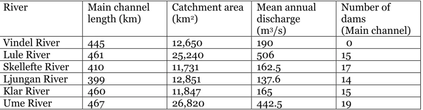
A total of six rivers were used in this study. They are similar in length and average discharge (table 1). They flow from the mountain range between Norway and Sweden, and four of them empty into the Gulf of Bothnia. The Klar River empties into Vänern, which is drained by the Göta River into Kattegatt, and the Vindel River merges with the Ume River 35 km from the coast of the Gulf of Bothnia. Biogeographically, the rivers run from a subalpine zone with mainly birch forests (Betula pubescens ssp. czerepanovii), to boreal forests dominated by Scots pine (Pinus sylvestris) and Norway spruce (Picea abies) (Jansson et al. 2000).
The only river that is entirely free flowing in this study is the Vindel River. It is 445 km long and has a catchment area of 12,650 km2. The mean annual discharge of the river is 190 m3/s, with large seasonal water-level fluctuations over the year. The river has its annual water-level maximum during the spring or early summer, which is caused by the snowmelt in the
mountains, followed by reduced flow during summer and a slight increase in autumn (Jansson et al. 2000).
The other five rivers (Lule-, Skellefte-, Ljungan-, Klar-, and Ume Rivers) are all heavily developed for hydroelectric power production. There are numerous dams in both the main channel and the tributaries.
Table 1. Geographical and hydrological data for the six rivers (SMHI).
River Main channel
length (km) Catchment area (km2)
Mean annual discharge (m3/s) Number of dams (Main channel) Vindel River 445 12,650 190 0 Lule River 461 25,240 506 15 Skellefte River 410 11,731 162.5 17 Ljungan River 399 12,851 137.6 14 Klar River 460 11,847 165 15 Ume River 467 26,820 442.5 19
In the six rivers, reaches with high flow velocity, representing conditions equivalent to rapids in free-flowing rivers, were selected. The aim was to have sites differing in hydrological and geomorphological impact, and that variation in hydrological and geomorphological impact would be orthogonal, i.e., vary independently from each other. Hydrological alteration stemmed from regulation to produce hydropower, which implied reduction in seasonal variation with lower spring flood water levels and higher winter flows compared to in free-flowing rivers, and short-term variation in flow and water-levels as a result of hydropeaking (Bejarano et al. 2018). Geomorphological alteration stemmed from clearing and
channelization to reduce channel roughness and increase flow velocity, to increase
hydropower production. Reaches may also be affected by channelization to facilitate timber floating (Nilsson et al. 2005). Selecting sites varying independently in geomorphological and hydrological alteration proved not to be possible, and sites were therefore instead selected in four categories:
5
(1) Rapids in free-flowing reaches of rivers, situated upstream of any dam or hydropower station, and geomorphological alteration only from modifications to facilitate timber floating. These are unaffected by exploitation from hydropower having a pristine flow regime but have been cleared to facilitate timber floating (Nilsson et al. 2005).
(2) Rapids with regulated flow, but with remaining fall height. Flow regimes are generally altered, having lower seasonal variation and varying intensity of hydropeaking, meaning sub daily to weekly shifts in discharge, including frequent periods of zero discharge, whereas geomorphological alteration is limited to clearing to facilitate timber floating in the past. These rapids have regulated flow with reduced seasonal variation, but the fall height remains (Englund and Malmqvist 1996).
(3) Reaches in run-of-river impoundments, where flow velocity is high as a result of narrow sections or some remaining fall height. Geomorphologically, they may be cleared but with some structural complexity of the bottom substrates remaining. Hydrologically, they are affected by hydropeaking, to match variation in hydroelectric production.
(4) Reaches in outlet channels below hydropower stations. These reaches have high flow velocity being artificial channels with low roughness. Hydrologically, seasonal flows are reduced, and hydropeaking intensity can be high since they are situated close to the hydropower station, with little or no dampening offered by intervening reaches with roughness features and volumes of water.
Site selection resulted in four reaches in rapids in flowing reaches (hereafter free-flowing), four in rapids with regulated flow (regulated rapids), six in impoundments (impounded reaches) and five in outlet channels. Tentatively, the four types of sites can be ranked from most pristine to most degraded in the same order as presented above, based on magnitude of hydrological alteration, the amount of geomorphological alteration to the channel bed, and finally the fall height along the reach.
Data on the hydrology, geomorphology, species composition of aquatic and riparian vascular plants, and presence of fish were collected from the 19 reaches in the six rivers (the Lule-, Skellefte-, Vindel-, Ljungan-, Klar-, and Ume Rivers). All the data except the fish and hydrological data were collected during field visits in the summer of 2019. The fish data originated from the Swedish Electrofishing Register, a national database for electrofishing data in Sweden; however, only 10 out of the 19 locations had fish data in the database.
At every site, a 150-m long study site was established and divided into six 25-m long sections. In the middle of each section, a 2-m wide transect running perpendicular to river from the channel edge to the thalweg was established. In the transect, the proportional cover of a number of sediment particle size classes in were judged after visual inspection from the shoreline and by a person investigating the transect using a dry suit. The sediment size classes were silt (<0.06 mm), sand (0.6 – 20.0 mm), gravel (0.2 – 16.0 cm), pebbles and cobbles (16.0 – 25.6 cm), boulders (> 25.6 cm) and bedrock, using the Wentworth scale (Wentworth 1922). In each section, the number of large boulders (larger than 1 m in
diameter) were counted, along with the number of pieces of large wood (longer than 1 m and with a diameter exceeding 10 cm). In addition, the degree to which the riparian zone
provided shading of the river channel was judged for each section, along with recording the three most common tree species in the riparian zone.
The presence of all aquatic vascular plant species growing along the 150-m reach was
recorded. Aquatic vascular plants are defined as species with the ability to grow permanently submerged. Some of these species can be called amphibious, i.e. having different growth forms when growing inundated or out of the water. In a 5o-m long stretch of riparian zone
6
placed in the centre of the 150-m long reach, 50x50 cm large plots were placed in three transects running from the annual high water (marked by the spring-flood peak level in free-flowing rivers) to the summer low water levels, with 20 cm in elevation between each plot. Within each plot, the percentage cover of vegetation and the presence of all vascular plant species rooted in them were recorded.
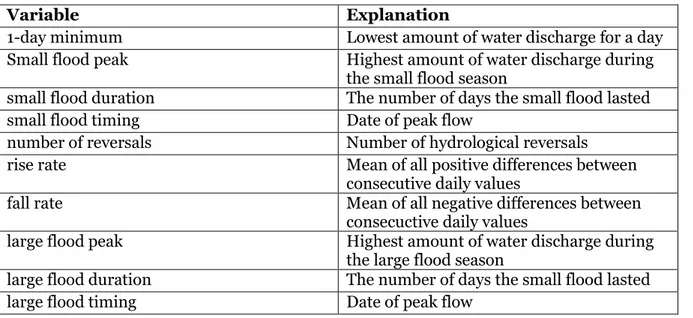
The data were analyzed with the help of R (R core team 2020), and the additional addons, ”Vegan” and “ggplot”. The hydrological data were analyzed with the program Indicators of Hydrologic Alteration (IHA) version 7.1 (The Nature Conservancy 2009). In my analysis, I utilized 10 of the variables that the IHA produced (1-day minimum flow, small flood peak, small flood duration, small flood timing, number of reversals, rise rate, fall rate, large flood peak, large flood duration and finally large flood timing; table 2).
Table 2. Explanation of the different hydrology variables (The Nature Conservancy 2009).
Variable Explanation
1-day minimum Lowest amount of water discharge for a day
Small flood peak Highest amount of water discharge during the small flood season
small flood duration The number of days the small flood lasted
small flood timing Date of peak flow
number of reversals Number of hydrological reversals
rise rate Mean of all positive differences between
consecutive daily values
fall rate Mean of all negative differences between
consecuctive daily values
large flood peak Highest amount of water discharge during the large flood season
large flood duration The number of days the small flood lasted
7
These 10 variables represent different aspects of the hydrological regime affecting ecosystem functioning in some way (table 3). The “1-day-minimum” variable can have an effect on life cycles for organisms: For example, it can influence stress, give access to special habitats and serve as a migration cue for migratory fish. “Small flood peak”, “Small flood timing”, “Small flood duration”, “large flood peak”, and “large flood duration” all have similar ecosystem functions, being related to flood events. They provide migration cues for migratory fish, trigger new phases in life cycles, enable fish to spawn on floodplains, provide nursery areas for juvenile fish, provide new feeding habitats and more (table 3). The “number of reversals”, “fall rate”, and “rise rate” variables describe rapid shifts in flow or water levels that can cause drought stress on plants, cause entrapment of organisms on islands, and desiccate low-mobility organisms that live near the stream edge. I chose these ten after discussing which variables are important to explain hydrological effects on the fish populations at the different locations.
Table 3. Ecosystem fuctions associated with hydrological variables used in the study (The Nature Conservancy 2009).
Variable Ecosystem functioning
1-day minimum Compatibility with life cycles, predictability of stress, access to special habitats,
spawning cues for migratory fish Small flood peak, small flood timing, small
flood duration, large flood duration, large flood peak, large flood timing
Provide new migration and spawning cues for fish, trigger new phase in life cycle, enable fish to spawn on floodplain, provide nursery area for juvenile fish, provide new feeding opportunites, maintain diversity in floodplain forest types through prolonged inudation, control distribution and
abundance of plants on floodplain, deposit nutrients on floodplain.
Number of reversals, rise rate, fall rate Drought stress on plants (falling levels), entrapment of organisms on islands and floodplains (rising levels) desiccation on low-mobility streamedge (varial zone) organisms
Correlation tests (Spearman tests) were done between all the geomorphology, aquatic vascular plants, riparian vegetation, fish population and hydrology variables to see if the different variables affect each other, and if the effect was positive or negative. I used the Shapiro test to determine if the data were normally distributed. Afterwards, I used either analysis of variance (ANOVA), for data with a normal distribution, or Kruskal Wallis tests, for non-normally distributed data, to determine if there was a significant difference (p < 0.05) between either fish populations, aquatic vascular plants, or riparian vegetation among the four different groups of sites. To explore differences between the four groups of sites I also created several different NMDS (Non-metric multidimensional scaling) figures to show the variation between the four groups. The figures were created with R.
8
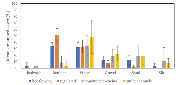
3 Results
The analysis of the geomorphology of the channel of the studied reaches showed that there were differences among the reach types (figure 1, table 4). The free-flowing reaches and regulated rapids were similar in sediment composition, having more boulders and less amount of sand and silt compared to the other two types of reaches. There were also tendencies of larger numbers of large boulders (boulder > 40 cm in diameter) in the free-flowing reaches and regulated-rapids reaches compared to the impounded reaches and outlet channels (table 4). However, only the difference for the cover of boulders was significant (P < 0.0001, one-way ANOVA), whereas the other substrate variables did not differ significantly from each other (P > 0.20, one-way ANOVA; boulders > 40 cm in size not tested).
Figure 1. The average amount of different geomorphology variables found at the four different regulation types. Error bars represent ± 1 S.E.
0 10 20 30 40 50 60 70 80 90 100
Bedrock Boulder Stone Gravel Sand Silt
Mean st reamb ed c ov er (%)
9
There was a lot of variance between sites in streambed cover for the different morphological variables (table 4).
table 4. The proportional cover of different sediment sizes on the channel bottom per location (%). The variable “Boulders > 40 cm” is the total number of boulders per site.
Location Regulation
type Bedrock (%) Boulder (%) Stone (%) Gravel (%) Sand (%) Silt (%) Boulder >40 cm ID Maltbränna free-flowing 0.00 26.66 20.83 20.83 21.67 10.00 106.00 6 Vännforsen free-flowing 0.00 36.66 33.33 15.00 13.33 3.33 71.00 7 Sölvbacka free-flowing 11.66 35.83 40.00 10.00 2.50 0.00 41.00 8 Nybergsund free-flowing 3.83 40.00 36.16 5.83 12.67 1.50 39.00 9 Nästelströmmen regulated-rapids 0.00 40.00 29.16 10.00 3.33 0.00 39.00 16 Haverö regulated-rapids 0.00 43.33 48.33 6.66 1.67 0.00 52.00 17 Strängfors regulated-rapids 0.00 61.66 35.00 2.83 0.50 0.00 56.00 18 Brattmon regulated-rapids 0.00 61.00 21.16 13.16 4.50 0.17 54.00 19 Kouka Impounded-reaches 0.00 4.00 18.50 31.66 45.83 0.00 8.00 10 Mattisudden Impounded-reaches 0.00 29.17 13.33 0.00 0.00 57.50 47.00 11 Krångfors Impounded-reaches 0.00 0.00 50.83 15.00 33.33 0.83 5.00 12 Selforsen Impounded-reaches 23.33 11.67 31.66 13.33 1.66 0.00 16.00 13 Granfors Impounded-reaches 0.00 0.83 57.50 25.00 16.66 0.00 1.00 14 Slussfors Impounded-reaches 0.00 6.67 38.33 27.50 18.33 9.17 14.00 15 Höljes outlet-channels 0.00 0.00 95.00 1.33 2.00 1.67 0.00 3 Bjurfors Ö outlet-channels 0.00 19.17 54.50 19.16 5.50 1.67 6.00 4 Tuggensele outlet-channels 0.00 0.00 26.16 30.00 33.83 14.50 0.00 5 Laxede outlet-channels 0.00 0.00 24.66 30.50 26.00 18.83 1.00 1 Bodens krv outlet-channels 0.00 0.00 41.66 30.67 26.00 1.67 2.00 2
10
The results of the NMDS (figure 2) for the composition of different sediment particle sizes in the streambed of the reaches show that the reach types differed in sediment composition, and that the impounded reaches exhibited more variation, with the other reach types mostly fitting within the impounded reaches.
Figure 2. NMDS of variables describing streambed sediment composition, showing the difference between the four reach types. Numbers denote different reaches, see table 1 for identification of the sites. Stress = 0.08
11
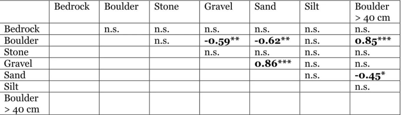
The correlation analyses of the streambed sediment variables showed that the larger sediment sizes (boulders, and the count of boulders larger than 40 cm) generally were negatively correlated with the proportion of smaller sediment sizes, such as gravel and sand (table 5). The cover of boulders and number of large boulders were positively correlated. There was also a positive correlation between the cover of gravel and sand.
Table 5. Correlations (Pearson product-moment correlations) among geomorphology variables describing the composition of sediment on the channel bottom (p< 0.05: *, p< 0.01: **, p< 0.001:***, n.s. = non-significant).
Bedrock Boulder Stone Gravel Sand Silt Boulder > 40 cm Bedrock n.s. n.s. n.s. n.s. n.s. n.s. Boulder n.s. -0.59** -0.62** n.s. 0.85*** Stone n.s. n.s. n.s. n.s. Gravel 0.86*** n.s. n.s. Sand n.s. -0.45* Silt n.s. Boulder > 40 cm
Comparison of hydrological variables before and after regulation shows most variables have changed following regulation. The changes in flooding periods for the reaches affected by regulation was large compared to the free-flowing reaches. There is also less of a high flood pulse for the outlet-channels and impounded reaches. Especially noteworthy are the small flood peaks and large flood peaks. In outlet channels, the reduction in large flood peak is larger than 90%, and the reduction in small flood peak is over 50%. The large flood peak for free-flowing reaches is between 700 and 800 m3/s, while for the outlet channels this peak was 1470 m3/s before alteration and only 108.26 m3/s after alteration. There is also a large reduction in peak floods for the impounded reaches, with a general decrease of over 50% compared to pre-alteration peaks (table 6).
12
Table 6. Mean of different hydrological variables before and after onset of regulation compared among the different reach types.
Hydrological
variable free-flowing regulated rapids impounded reaches outlet channels 1-day minimum pre (m3/s) 21.31 16.79 45.72 76.21 1-day minimum post (m3/s) 28.15 28.61 36.57 89.05 Small flood peak pre (m3/s) 547.38 301.05 657.83 1035.76 Small flood peak post (m3/s) 591.73 325.43 417.17 431.72 small flood duration pre (days) 68.07 59.09 79.84 73.34 small flood duration post (days) 68.48 35.57 19.33 19.06 small flood timing pre (start date) 152.98 146.95 175.37 173.02 small flood timing post (start date) 158.55 149.58 109.33 110.68
large flood peak pre (m3/s)
733.25 441.25 772.83 1470.00
large flood peak post (m3/s) 812.53 372.60 321.17 108.26 large flood duration pre (days) 47.50 46.00 76.67 69.20 large flood duration post (days) 45.98 32.50 7.83 10.40 large flood timing pre (start date) 137.50 134.75 181.50 163.80 large flood timing post (start date) 145.98 121.50 70.00 35.34 number of reversals pre (number) 40.02 58.43 40.42 38.41 number of reversals post (number) 46.19 91.31 135.78 150.56
rise rate pre 7.50 6.27 7.82 13.54
rise rate post 8.55 6.68 24.17 34.37
fall rate pre -3.41 -3.06 -3.76 -6.30
13
The results of the NMDS analysis for the hydrological variables (figure 3) show that the free-flowing and regulated rapids differ from the impounded reaches and the outlet channels, the latter two overlapping with each other. Further, there is less variation among sites for the free-flowing and regulated rapid reaches than the impounded and outlet channel reaches. There was also a separation along the NMDS1 dimension of the free-flowing reaches
compared to all other reaches, while there is large overlaps in the NMDS2 dimension among the reach types.
Figure 3. NMDS of the hydrological variables compared among the different reach types. Numbers denote different reaches, see table 1 for identification of the sites. Stress = 0.06.
The correlation analyses on the hydrological variables showed that there were many significant (p < 0.05, table 7) and strong correlations between variables, either negative or positive. For example, the variables that describe high flood pulses were positively correlated with each other. The variables describing rate of change (rise/fall rates, reversals) were also positively correlated. Moreover, there were negative correlations between the high flood pulse variables and the fast-changing variables.
14
Table 7. Correlation matrix for the hydrological variables (p< 0.05: *, p< 0.01: **, p< 0.001:***, n.s. = non-significant). 1 day minimum Small flood
peak Small flood duration Small flood timing Number of reversals Rise rate Fall rate Large flood duration Large flood timing Large flood peak 1-day minimum n.s. n.s. n.s. n.s. n.s. n.s. n.s. n.s. 0.46* Small flood peak n.s. 0.69*** n.s. n.s. n.s. 0.54* n.s. 0.53* Small flood duration 0.71*** n.s. 0.53* 0.62** 0.66** 0.52* n.s. Small flood timing n.s. n.s. n.s. n.s. n.s. n.s. Number of reversals 0.79*** -0.88*** -0.67* n.s. -0.53* Rise rate -0.96*** -0.6** -0.51* n.s. Fall rate 0.65** 0.51* n.s. Large flood duration n.s. 0.8*** Large flood timing 0.86*** Large flood peak
15
There were several strong correlations also between the hydrological and the
geomorphological variables (table 8). Boulders were positively correlated with high flood variables, and negatively correlated with variables that are associated with fast changes in flow regime. Rise rate and fall rate were also positively correlated with smaller sediment sizes, such as gravel, sand, and silt.
16
Table 8.Correlation matrix showing correlations between hydrological and channel-bottom variables (p< 0.05: *, p< 0.01: **, p< 0.001:***, n.s.. = non-significant).
Bedrock Boulder Stone Gravel Sand Silt Boulder > 40
cm 1-day minimum n.s. n.s. n.s. n.s. n.s. n.s. n.s. Small flood peak n.s. n.s. n.s. n.s. n.s. n.s. n.s. Small flood duration n.s. 0.57** n.s. 0.72*** -0.51* n.s. 0.58*** Small flood timing n.s. n.s. n.s. -0.54* n.s. n.s. n.s. Number of reversals n.s. -0.53* n.s. n.s. n.s. n.s. -0.63** Rise rate n.s. -0.69*** n.s. 0.65*** 0.53* 0.47* -0.53* Fall rate n.s. -0.69*** n.s. 0.57 n.s. n.s. 0.61** Large flood peak n.s. n.s. n.s. n.s. n.s. n.s. n.s. Large flood duration n.s. n.s. n.s. -0.52* n.s. n.s. 0.5* Large flood timing n.s. n.s. n.s. n.s. n.s. n.s. n.s.
17
When using Kruskal-Wallis tests there was a difference in fish species richness among the four types of alterations (p < 0.049). There was a significant difference in species richness when comparing impounded reaches with both outlet channels (p < 0.042) and regulated rapids (p < 0.04). Also, grayling (Thymallus thymallus) abundance differed between impounded reaches with outlet channels (p < 0.05) (figure 4).
The impounded reaches had the highest number of fish species richness with an average of 7.6 species per location, while the regulated rapids had the lowest species richness with an average of 4 species per location. The same pattern was seen for grayling abundance (figure 4).
Figure 4. Fish species richness and grayling richness for the regulation types on the reaches. Error bars represent ± 1 S.E.
A total of 17 fish species were found at the 10 different reaches from which electrofishing data were available (table 9). Brown trout (S. trutta) was only found in one location, and Atlantic salmon (S. salar) was found only in the regulated rapids in the Klar river. Graylings (T.
thymallus) were found in most rivers, regardless of regulation type. 0 1 2 3 4 5 6 7 8 9
regulated rapids impounded reaches outlet channels
S pe ci es ri chness
18
19
The abundance of grayling was the only fish species that was significantly correlated with either the geomorphology or hydrology variables, showing negative correlations with small flood timing (r = -0.67, p < 0.05) and silt (r = -0.81, p < 0.01).
The fish NMDS (figure 5) shows that the species composition of fish differed among reach types, forming separate clusters. Data were lacking for the free-flowing reaches.
Figure 5. Fish NMDS. showing the difference is fish community composition between the different reach types. ID 1 =Laxede, 2 = Höljes, 3 = Bjurfors Ö, 4 = Tuggensele, 5 = Kouka, 6 = Mattisudden, 7 = Krångfors, 8 = Selsforsen, 9 = Granfors, 10 = Strängfors, 11 = Brattmon. Stress = 0.18.
20
The outlet channels had the least amount of plant cover compared to all other reach types. There was a difference between free-flowing and outlet channels (p < 0.01), between
regulated rapids and outlet channels (p < 0.01), and between impounded reaches and outlet channels (p < 0.01), (figure 6).
Figure 6. Riparian plant cover (%) for the four different river groups. Error bars represent ± 1 S.E.
0 10 20 30 40 50 60
free-flowing impounded reaches outlet channels regulated rapids
m ean rip ar ian p lan t cov er p er p lot (% )
21
The outlet channels had the lowest number of riparian plant species richness compared to the other reach types. However, the only significant difference found was between free-flowing and outlet channels (p < 0.02), and impounded reaches and outlet channels (p < 0.04), (figure 7).
Figure 7. Riparian plant species richness per regulation type. Error bars represent ± 1 S.E.
0 20 40 60 80 100 120
free-flowing impounded reaches outlet channels regulated rapids
R ip arian pl ant sp ecies ri ch ness
22
Mean plant coverage varied a lot between locations and reach types (table 10) with the lowest percentage cover being at Laxede (1.9%) and the highest being Sölvbacka (63.7%).
Table 10. Mean and median riparian plant cover per plot and location.
River Site Reach type Mean plant cover
average (%) Median plant cover (%) Vindel River Maltbränna Free flowing 38.6 40
Vindel River Vännforsen Free flowing 26.5 15 Ljungan River Sölvbacka
strömmar
Free flowing 63.7 75 Klar River Nybergssund Free flowing 39.4 35 Ljungan River Nästelströmmen Regulated rapids 27.8 20 Ljungan River Haverö strömmar Regulated rapids 10.9 0 Klar River Strängforsen Regulated rapids 31.2 22.5 Klar River Brattmon Regulated rapids 18.8 5 Lule River Kouka Impounded reaches 35.6 27.5 Lule River Mattisudden Impounded reaches 45.2 40.5 Skellefte River Krångfors Impounded reaches 43.6 39 Skellefte River Selforsen Impounded reaches 42.1 37.5 Skellefte River Granfors Impounded reaches 13.8 6 Ume River Slussfors Impounded reaches 29 25 Lule River Laxede Outlet channels 1.9 0 Lule River Bodens krv Outlet channels 5 2.5 Klar River Höljes Outlet channels 12.1 5 Ume River Bjurfors Ö Outlet channels 6 1 Ume River Tuggensele Outlet channels 9.5 3
There was no significant difference in species richness of aquatic vascular plants among reach types (p > 0.5), (figure 8), with the mean species richness ranging from 5,5 in free-flowing reaches to 8,6 in impounded reaches.
Figure 8. Mean species richness aquatic vascular plants per study site. Error bars represent ± 1 S.E.
0 2 4 6 8 10 12
free flowing regulated rapids outlet channels impounded reaches
Sp ecies ri ch ness per st u d y site
23
There was no difference in species composition of aquatic vascular plants among the different reach types, as indicated by the NMDS analysis, given that the NMDS of different reach types had overlapping site scores (figure 9).
Figure 9. NMDS for aquatic plants, showing the different reach types (outlet channels, impounded reaches, regulated rapids and free-flowing reaches) as well as the different locations. The NMDS shows the variation in aquatic plant species composition within and among reach types. Stress = 0.12.
24
4 Discussion
My hypothesis was that all species groups will be negatively affected by the changes, but this was not the case. Human alteration negatively impacted both fish species richness and riparian plant species richness, but the aquatic vascular plants remained unaffected. I could also not link the differences in riparian species richness and fish species richness between the four reach types to any specific hydrology or geomorphology variable that I studied in this thesis.
4.1 Geomorphology
My results show that human alteration to rivers changes the bottom sediment
geomorphology in the reaches studied in this thesis. The largest difference between the reach types is that free-flowing and regulated rapids have significantly more boulders than the impounded reaches and outlet channels. The reason for this difference in the number of boulders is due to the building of hydropower plants and timber floating. When building hydropower plants or when changing the river to facilitate timber floating the removal of large boulders and boulders is a common practice, and the impounded reaches and outlet channels has been affected by this type of removal (Englund and Malmqvist 1996). The loss of the larger substrates in the impounded reaches and outlet channels will negatively impact the riverine ecosystem in numerous ways. Larger substrates, such as boulders act as a refuge from the water flow, by creating areas of calmer water that lets the fish species and other species rest from the constant water flow downstream. The boulders also help with the sedimentation process, since the calmer water allows smaller substrates to sediment in the area. The removal of boulders will also decrease the displacement of water to the riparian zone, which can potentially lead to less flooding, which can lead to the desiccation of riparian plants. The heterogeneity of the ecosystem will also decrease because of the loss of boulders, and a decrease in heterogeneity, usually leads to a decrease in biodiversity (Palmer et al. 2010). Because of the important role that the larger substrates have in a riverine ecosystem and the effect it has on the riparian zone, the removal of these boulders to facilitate
hydropower and timber-floating should negatively impact species that live in the riverine ecosystem and the riparian zone (Bunn and Arthington 2002; Drinkwater et al 1994; Elosegi et al. 2010).
The reason why free-flowing reaches and regulated rapids had less variation in bottom sediment geomorphology compared to the impounded reaches and outlet channels can be explained by the differences in the sedimentation processes for these reaches (Palmer et al. 2010; Ward et al. 1999). In the impounded reaches and outlet channels the sedimentation process is largely controlled by the release of water from the dams and hydropower plants, resulting in a less stable sedimentation process (Brandt 2000). There is also a more unstable erosion process in the outlet channels and impounded reaches with the rapid change of water levels caused by the release of water to produce electricity. The fact that the sedimentation and erosion processes in the impounded reaches and outlet channels are heavily influenced by human alteration leads to a heavily localized variation in sedimentation and erosion in these reach types. This localized variation is largely dependent on the size of the hydropower plants (Brandt 2000; Näslund 2013).
The positive correlation between geomorphology variables can be explained by the variation in water discharge and the amount of human alteration in the reaches. Free-flowing reaches and regulated rapids, which are reaches that have more boulders and larger boulders
compared to impounded reaches and outlet channels, are less affected by human alteration and hydropeaking. Reaches that are heavily affected by hydropeaking should have a larger number of smaller substrates compared to the number of boulders and larger boulders, since
25
these areas are cleared to facilitate hydropower plants and timber floating. This can explain why the variables fall rate and rise rate, which describes fast changes in water levels and is associated with hydropeaking, are positively correlated with smaller substrates, and
negatively correlated with larger substrates like boulders. This also explains why the smaller substrates are negatively correlated with the larger substrates while being positively
correlated with other smaller substrates, since areas affected by hydropeaking will have more smaller substrates and less large substrates.
4.2 Hydrology
There are clear changes in hydrology for regulated rapids, impounded reaches, and outlet channels. Regulated rapids are the least affected by the changes in hydrology, followed by the impounded reaches and finally the outlet channels, as shown in table 6 and figure 3. These differences can be explained by the distance from the hydropower plants and how much of a dampening effect the environment provides.
Regulated rapids are the reaches that are the least affected by the change in hydrology. They are also the reach type that is the furthest away from the hydropower plants. The distance between the hydropower plant and regulated rapids will dampen the effect of the change in hydrology, which can explain why the largest change in hydrology in the regulated rapids is the timing and duration of flood events, since these variables are still highly affected by the release of water from the dams (Bednarek 2001; Vannote 1980). The impounded reaches are also far away from the hydropower plants upstream, but they are closer to hydropower plants downstream. Because of the hydropeaking in downstream hydropower plants, the seasonal variety and peak floods will be heavily affected, which is also confirmed by data shown in table 6. Outlet channels are the reach type that is most affected by hydropeaking and the change in hydrology, they are also the reach type that is closest to the hydropower plants. There is no dampening effect provided by the environment at all for the outlet channels since they are close to the hydropower plants and all the roughness in the water channels has been removed.
The hydrological regime of the reaches in this study can be largely controlled to benefit human needs. This change in hydrological regime will have a profound effect on the riverine ecosystem and the riparian zone since the flow regime of the river is the process behind all physical processes in the river (Nilsson et al. 2005; Näslund 2013). The damming of the river will reshape the entire riverine ecosystem. When the dam is built the area upstream of the dam will change from being a lotic ecosystem to a more lentic ecosystem (Näslund 2013). This in turn will change the sediment deposition for the area, affecting the geomorphology and habitats in the riverine ecosystem and in the riparian zone. The impounded reaches and outlet channels are affected by hydropeaking, as shown by e.g. rapid fall and rise rates (Bejarano et al. 2018). The loss of sediment transportation downstream will negatively influence the riverine ecosystem, since a lot of species are reliant on these sediment transport for the continuation of their habitat, both in terms of substrate availability and the nutrients these substrates provide (Poff et al. 1997). Nevertheless, the loss of seasonal variety in water flow is perhaps the most detrimental loss for the riverine ecosystem and causes a decrease in biodiversity. The loss of seasonal variety leads to a decrease of stress events during the year and the seasonal variety acts as a trigger for many species, ranging from spawning cues to
26
migration cues and the triggering of new phases in the life cycle (Junk et al. 1989; Poff et al. 1997).
4.3 Biological variables
The four reach types are clearly divided into two groups, based on the geomorphology and hydrology variables. The free-flowing rivers and regulated rapids are one group, while the impounded reaches and outlet channels are the other. But the effect this difference has on the biological variables such as fish populations, aquatic vascular plants, and riparian vegetation is not as obvious.
My hypothesis was that the least altered reaches should have the highest number of fish species richness, but it was instead the impounded reaches that had the most fish species, and even outlet channels had more fish species than regulated rapids. However, the lack of data for the regulated rapid can explain these results, and because of this, and because I had no data for the free-flowing group, I will discuss the differences between impounded reaches and outlet channels.
Both impounded reaches and outlet channels have had their streambed sediment
composition change due to human alteration. The biggest difference between the streambed sediment composition for these two types of reaches compared to the free-flowing rivers and the regulated rapids is the loss of boulders and large boulders. This loss of heterogeneity should lead to less biodiversity in the area, which is the generally accepted theory (Palmer et al. 2010; Tews et al. 2004; Vinson and Hawkins 1998). However, the decrease in
heterogeneity might not be the main reason for the differences observed in fish populations in this thesis.
The distance from the hydropower plants and dams, and the changes in hydrology, and especially the large decrease in flood peaks and the effects caused by hydropeaking, might also be a reason for the differences in fish populations. As mentioned previously, the outlet channels are just below the hydropower plants, and is also the reach type most heavily affected by hydropeaking and has the largest decrease of flood peaks. There is also no
dampening effect from the environment when hydropeaking occurs. The impounded reaches are further away from the hydropower plants and are less impacted by the change in
hydrology and hydropeaking. Previous studies have shown that hydropeaking and a decrease in flood peaks negatively affects fish populations, which could explain why there was
significantly more fish species and significantly more grayling richness in the impounded reaches compared to the outlet channels (Jansson et al. 2000). The reason that no anadromous fish species, such as S. salar, was found in any impounded reaches or outlet channels is not because of the change in hydrology or geomorphology in these reaches. S.
salar is instead limited by the physical barrier that the dams create, since they cannot pass
this obstacle to return upstream.
The change from a lotic to lentic environment caused by the building of dams and
hydropower plants should also have a large effect on the species population in the riverine ecosystem. This change from lotic to lentic habitat may result in local extinction of some species, and that some species that was previously migratory will become stationary
27
change from primarily being composed of lotic species to dominance of lentic species.
However, despite such changes in the types of fish that can live there, the total amount of fish species living in the habitat does not necessarily decrease (Bunn and Arthington 2002). This is what has been observed in this thesis as well. Both the impounded reaches and outlet channels have fish that are more common in lentic environments, such as P. fluviatilis and E.
lucius, and these fish species were not found in the regulated rapids. If the main goal of a
restoration project is to have high species richness, then it is not necessarily better to return to the old lotic environment. But if the goal is instead to maintain a population of migratory species, then the removal of dams and other blocking factors is required.
The difference in plant cover was highly significant (p < 0.01) between the four groups. In contrast to the previous study by Jansson et al. (2000), the plant cover of impounded reaches was similar to the free-flowing and regulated rapids. The reason for this might be because of a difference in substrate availability in the riparian zone. In my thesis the reaches studied might have more substrate available in the riparian zone, which would allow the plant cover to be high (Jansson et al. 2000). The large difference observed for the outlet channels compared to the other regulation types in riparian plant cover can be explained by both substrate availability and hydrology. In the outlet channels the riparian zone is largely covered by large boulders and boulders that were put there when the dams were built. This would limit the substrate availability for the riparian plants. The outlet channels are also more affected by the hydrology changes, due to distance from hydropower plants and the lack of any dampening effect.
One major way for riparian plants to populate areas in the riparian zone is through seed dispersal by water (Bednarek 2001; Jansson et al 2000). In the outlet channels, this method of dispersal should be extremely limited. The decrease in seed dispersal through water combined with the decrease in substrate availability could explain why the outlet channels have fewer riparian plant species compared to both free-flowing rivers and impounded reaches. However, the reason why there was no significant difference between regulated rapids and outlet channels is not as clear, it might be because in these specific regulated rapids there is also a lack of substrate availability, or the dispersal of seeds is limited. There was no significant difference in aquatic vascular plant species richness between the
regulation types, showing that variables studied in this thesis did not have a big impact on the aquatic vascular plants.
One relatively easy way to improve the habitat of impounded reaches and outlet channels and make them more similar to the less altered free flowing reaches and regulated rapids is to reintroduce boulders and large boulders into the reaches. A natural river has a highly complex bottom sediment geomorphology with many different sediment types and sizes, which increases biodiversity (Näslund 2013). By reintroducing boulders and large boulders there will be more areas with calmer water, which would benefit important species for human interests (Zika and Peter 2002). This type of restoration method of reintroducing large boulders is quite commonly used in projects aimed to restore reaches to a more natural habitat (Karlsten 2019). However, this restoration project type will most likely not be enough if the goal is to restore the habitat and benefit the species reliant on these habitats, since these species are also affected by the change in hydrology.
28
4.4 Conclusion
The major change in geomorphology when comparing all four types of reaches is the decrease in large substrates such as boulders and large boulders. However, the loss of these substrates cannot by themselves explain the differences between the reaches when comparing fish population, riparian plant species richness, and aquatic vascular plant richness. Hydropower plants and timber floating have both negatively impacted the riverine ecosystem, and in turn caused a decrease in species richness for fish and riparian plants. The reaches studied in this thesis will continue to be change due to the effects of hydropower plants and the changes caused by timber floating and the species richness and species composition will change from an ecosystem that relied on the natural flow regime to an ecosystem more used to the flow regime created by the hydropower plants. The change in hydrology and the decrease in seasonal variety will surely continue to affect the remaining species, and the interaction these hydrology changes have with the geomorphological changes should be studied further. Since it is this interaction that will shape the new ecosystems and in turn control which species that can continue to thrive in the riverine and riparian ecosystems.
29
5 Acknowledgements
I would like to give thanks to my supervisor, Roland Jansson, that helped me throughout the thesis with any questions I had and helped me increase my knowledge and understanding of my thesis topic.
I would also like to thank my friends and family that kept me motivated to finish this thesis and was there during all the ups and downs during this long process.
30
6 References
Aarts, B., Van Den Brink, F. and Nienhuis, P. 2004. Habitat loss as the main cause of the slow recovery of fish faunas and regulated rivers in Europe: The transversal
floodplain gradient. River research and Applications 20: 3-23. Bednarek, T. A. 2001. Undamming Rivers: a review of the ecological impacts of dam
Removal. Environmental Management 27: 803-814.
Brandt, A. 2000. Classification of geomorphological effects downstream dams. Catena 40: 375–401.
Bunn, S. E., and Arthington, A. H. 2002. Basic principles and ecological consequences of altered flow regimes for aquatic biodiversity. Environmental Management 30: 492-507.
Drinkwater, K. F., and K. T. Frank. 1994. Effects of river regulation and diversion on marine fish and invertebrates. Aquatic Conservation: Freshwater and Marine
Ecosystems 4:135– 151.
Dynesius, M. and Nilsson, C. 1994. Fragmentation and flow regulation of river systems in the northern third of the world. Science, 266(5186), 753-762.
Elosegi A., Diez, J. and Mutz, M. 2010. Effects of hydromorphological integrity on
biodiversity and functioning of river ecosystems. Hydrobiologia 657:199-215 Englund, G. and Malmqvist, B. 1996. Effects of flow regulation, habitat area and isolation on
the macroinvertebrate fauna of rapids in north Swedish rivers. Regulated
Rivers-Research & Management 12:433-445.
Heggenes, J., Qvenild, T., Stamford, M. D., and Taylor, E.B. 2006. Genetic structure in relation to movements in wild European grayling (Thymallus thymallus) in three Norweigan rivers. Canadian Journal of Fisheries and Aquatic Sciences
63: 1309-1319.
Jansson, R., Nilsson, C., Dynesius, M., Andersson, E. 2000. Effects of river regulation on river-margin vegetation: a comparison of eight boreal rivers. Ecological
Applications 10: 203-224.
Junk, W. J., Bayley, P.B. and Sparks, R. E. 1989. The flood pulse concept in
river-floodplain systems. Canadian Journal of Fisheries and Aquatic Sciences 106: 110-127.
Karlsten, A. 2019. Quantifying the physical effects of stream restoration: with unmanned aerial vehicles and geographical information systems. M.Sc. Thesis. Department of Ecology and Environmental Science, Umeå University, Sweden.
Lepori, F., Palm, D., Brännäs, E. and Malmqvist, B. 2005. Does restoration of structural heterogeneity in streams enhance fish and macroinvertebrate diversity?
Ecological Applications 15: 2060-2071.
Nilsson, C., Lepori, F., Malmqvist B., Törnlund E., Hjerdt N., Helfield M.J., Palm, D., Östergren, J., Jansson, R., Brännäs E., Lundqvist H. 2005. Forecasting Environmental responses to restoration of rivers used as log floatways: an interdisciplinary challenge. Ecosystems 8: 779-800.
31
Näslund, I., Kling, J. and Bergengren, J. 2013. Vattenkraftens påverkan på akvatiska ekosystem – en litteratursammanställning. Havs- och vattenmyndighetens rapport 2013:10.
Palmer, M., Menninger, H. and Bernhardt, E. 2010. River restoration, habitat heterogeneity and biodiversity: a failure of theory or practice? Freshwater Biology 55: 205-222
Petts, G.E. 1984. Impounded rivers: Perspectives for ecological management. Chichester, England: John Wiley & Sons.
Poff, N.L., Allen, J.D., Bain, M.B., Karr, J.R., Prestegaard, K.L., Richter, B.D., Sparks, R.E. and Stromberg, J.C. 1997. The natural flow regime: A paradigm for river conservation and restoration. BioScience. 47: 769–784.
Renöfält, M. B., Jansson, R. and Nilsson, C. 2010. Effects of hydropower generation and opportunities for environmental flow management in Swedish riverine ecosystems. Freshwater Biology 55: 49-67.
R core team (2020). R: A language and environment for statistical computing. R foundation for statistical Computing, Vienna, Austria. URL http://www.R-project.org/ SMHI. 2020. Vattenwebb. Mätningar. Station 1703, 1650, 1733, 2237, 1870, 2131.
https://vattenwebb.smhi.se/station/# (Retrieved 2020-12-18).
Tews, J., Brose, U., Grimm, V., Tielbörger, K., Wichmann, M. C., Schwager, M., and Jeltsch, F. 2004. Animal species diversity driven by habitat heterogeneity/diversity: the importance of keystone structures. Journal of Biogeography, 31(1), 79-92. Therrien, J., and Bourgeois, G. 2000. Fish passage at small hydro sites. Report by Genivar
Consulting Group for CANMET Energy Technology Center, Ottawa. 114 p. The Nature Conservancy. 2009. Indicators of Hydrological Alteration Version 7.1 User’s
Manual.
Törnlund, E. and Östlund, L. 2002. Floating timber in northern Sweden: The construction of Floatways and Transformation of rivers. Environment and History 8: 85– 106.
Vannote, R. L., Minshall, G. W., Cummins K. W., Sedell, J. R., and Cushing, C. E. 1980. The river continuum concept. Canadian Journal of Fisheries and
Aquatic Sciences, 37(1), 130-137.
Vinson, R. and Hawkins, P. 1998. Biodiveristy of stream insects: variation at local, basin and regional scales. Annual review of Entomology 43: 271-293
Ward, J. V., Tockner, K. and Schiemer, F. 1999. Biodiversity of floodplain river ecosystems: ecotones and connectivity1. River Research and Applications 15: 125-139. Wentworth. 1992. A scale of Grade and Class Terms for Clastic Sediments. The journal of
geology 30: 377-392
Zika, U. And Peter, A. 2002. The introduction of woody debris into a channelized stream: effect on trout populations and habitat. River Research and Applications 18: 355-366.