IN
DEGREE PROJECT DESIGN AND PRODUCT REALISATION, SECOND CYCLE, 30 CREDITS
,
Drones in arctic
environments
MARIA ADER
DAVID AXELSSON
Drones in arctic environments
Maria Ader
David Axelsson
Master of Science Thesis MMK 2017: 108 IDE 290 KTH Industrial Engineering and Management
Machine Design SE-100 44 STOCKHOLM
Abstract
This is a master thesis by Maria Ader and David Axelsson, students at the Master of Science in Engineering degree program in Design and Product Realization at KTH, within the master program Integrated Product Design. The thesis work will benefit ÅF and the EU project ɪɴᴛᴇʀᴀᴄᴛ.
The ɪɴᴛᴇʀᴀᴄᴛ project is part of the EU’s effort to forward climate research, and aims to “coordinate and harmonize research and monitoring efforts that will greatly contribute to our knowledge and understanding of changes occurring in the arctic environment.” One out of 12 subprojects within ɪɴᴛᴇʀᴀᴄᴛ aims to “increase awareness of drone technology and sensors among researchers and research station managers while making industry aware of innovative potential uses requiring drone and sensor development.”
A drone is an unmanned aerial system/vehicle (UAS/UAV), i.e. an airborne vehicle without a human pilot aboard. This master thesis examines the need of drones at the ɪɴᴛᴇʀᴀᴄᴛ research stations and how arctic climates affect drone technology and the ergonomics of piloting a drone. The thesis also provides an overview of the current state of the drone market and the laws and regulations that affect the use of drones.
A survey was distributed within ɪɴᴛᴇʀᴀᴄᴛ to map the researchers’ need of, and attitudes towards, drones, followed by exhaustive interviews with researchers and other key figures. Field testing at Tarfala Research Station provided complementing data.
The primary insight from the study was that the researchers’ need, as well as the tasks and methods that they employ, vary greatly.Another insight was that many researchers want to use drones primarily as a sensor platform to collect data from large areas in a short time span. A situation-based drone recommendation and a concept proposal for a simple water sampling solution were made based on the results of the study.
Keywords: Drones, UAV, UAS, RPAS, Arctic, ɪɴᴛᴇʀᴀᴄᴛ, Climate, Research, Autonomous, Water sample, Tarfala, Multicopter, Fixed-wing.
Master of Science Thesis MMK 2017: 108 IDE 290 Drones in arctic environments
Maria Ader David Axelsson Approved 2017-09-14 Examiner Claes Tisell Supervisor Claes Tisell Commissioner ÅF AB Contact person Tomas Gustafsson
Sammanfattning
Detta är ett examensarbete utfört av Maria Ader och David Axelsson, studenter på civilingenjörsprogrammet Design och Produktframtagning på KTH, med masterinriktning Teknisk Design. Arbetet är utfört åt ÅF i syfte att bidra till EU-projektet ɪɴᴛᴇʀᴀᴄᴛ.
Iɴᴛᴇʀᴀᴄᴛ är EU:s satsning på klimatforskning i Arktis och syftar till att “koordinera och harmonisera forskning och miljöbevakning som bidrar till vår kunskap och förståelse av förändringar som sker i de arktiska miljöerna.” Ett av tolv delprojekt inom ɪɴᴛᴇʀᴀᴄᴛ-projektet syftar till att öka medvetenheten om drönarteknologi och sensorer bland forskare och föreståndare på forskningsstationerna inom ɪɴᴛᴇʀᴀᴄᴛ, samt att göra drönarindustrin medveten om nya potentiella användningsområden.
En drönare är ett obemannat luftfartyg, d.v.s. en flygfarkost utan pilot ombord. Drönare benämns ibland som “UAS” och “UAV”. I den här rapporten används främst den engelska termen “drones”. Detta examensarbete undersöker behovet av drönare på de forskningsstationer som är delaktiga i ɪɴᴛᴇʀᴀᴄᴛ och hur det arktiska klimatet påverkar drönartekniken och ergonomin. Arbetet kartlägger även drönarmarknaden och de lagar och regler som påverkar användandet av drönare.
En utförlig studie genomfördes, där forskarnas behov av drönare undersöktes. En enkät skickades ut inom ɪɴᴛᴇʀᴀᴄᴛ och utförliga intervjuer genomfördes med forskare och andra nyckelpersoner. Ett studiebesök på Tarfala forskningsstation kompletterade med fältdata. Den främsta insikten från studien var att behov, arbetsuppgifter och metoder varierar mycket mellan de olika forskarna. En annan insikt var att många ville använda drönare som sensorbärare, och på så sätt insamla data från stora områden på kort tid.
Resultatet från studien låg till grund för en situationsbaserad drönarrekommendation samt ett konceptförslag för en enkel vattenprovtagningslösning.
Nyckelord: Drönare, UAV, UAS, RPAS, Arktis, ɪɴᴛᴇʀᴀᴄᴛ, Klimat, Klimatforskning, Autonom, Vattenprov, Tarfala, Multikopter.
Examensarbete MMK 2017: 108 IDE 290 Drönare i arktiska miljöer
Maria Ader David Axelsson Godkänt 2017-09-14 Examinator Claes Tisell Handledare Claes Tisell Uppdragsgivare ÅF Technology Kontaktperson Tomas Gustafsson
Acknowledgments
We, the thesis authors, would like to thank all the researchers and station managers who contributed to this thesis with their time and expertise.
We would like to express our sincere gratitude to Gunhild Rosqvist for inviting us to Tarfala Research Station and providing us with countless insights from the world of arctic research.
Our sincere thanks also go to the drone professionals, whose technical knowledge we would not have managed without, and to all the other professionals and enthusiasts, for their information and inspiration.
A special thanks to our supervisors for keeping us on the right track throughout the project: Tomas Gustafsson and Johan Rössner at ÅF, and Claes Tisell at KTH. We would also like to thank Tor Ericson and Eskil Bendz for their feedback and support throughout the project.
David Axelsson Maria Ader
Table of contents
1. Introduction ... 1
1.1. Objective ... 1
1.2. Purpose and goals ... 1
1.3. Delimitations ... 2
1.4. Terminology ... 2
1.5. Methods ... 2
2. Background ... 4
2.1. The ɪɴᴛᴇʀᴀᴄᴛ stations ... 4
2.2. Climate effects on drones and examples of countermeasures ... 6
2.3. State of the art ... 8
2.4. Services and systems ... 11
3. Laws and regulations regarding drones ... 13
3.1. Current regulations in Sweden ... 13
3.2. Upcoming regulations ... 15
3.3. Legal challenges of ɪɴᴛᴇʀᴀᴄᴛ ... 17
4. Using drones in arctic research ... 18
4.1. Survey ... 18
4.2. Follow up interviews ... 20
4.3. Compilation and analysis of interview answers ... 21
4.4. Site visit: Tarfala Research Station ... 28
4.5. Results and analysis of costumer experience mapping ... 29
4.6. Interview with experienced drone pilot ... 32
4.7. Interviews with drone manufacturers ... 33
5. Concept: Airborne water sampler ... 37
5.1. Bill of materials ... 39
5.2. Payload effects on drone capacity ... 40
6. Conclusion of study ... 41
6.1. Insights ... 41
7. Guideline for drone implementation ... 44
7.1. Aspects to consider ... 44
7.2. Advantages and disadvantages ... 44
7.3. Decision matrix ... 46
8. Discussion ... 48
8.1. Approach ... 48
8.2. Proposition for future work ... 49
References ... 50
Appendix 1: Past, present and future of drones ... 54
Appendix 2: The survey ... 62
Appendix 3: Interview guideline ... 68
1. Introduction
The Arctic is one of the regions that is most affected by Earth’s changing climate [1]. Understandably, large research efforts are being made in this region. Arctic research is highly dependent on the collection of environmental data and samples for analysis. The collection methods differ in nature depending on the type of sample; some require researchers to perform tedious and/or dangerous activities [2]. Alternate, safer and more efficient methods for data and sample gathering may be possible with the use of new technologies.
Iɴᴛᴇʀᴀᴄᴛ is an EU project with the main goal to “coordinate and harmonize research and monitoring efforts that will greatly contribute to our knowledge and understanding of changes occurring in the arctic environment” [3]. The project scope is wide, with different plans to ease data gathering and communication of results. The goal of one subproject within ɪɴᴛᴇʀᴀᴄᴛ, referred to as Work Package 8, is to “increase awareness of drone technology and sensors among researchers and research station managers while making industry aware of innovative potential uses requiring drone and sensor development” [4].
Umbilical Design [5] is responsible for the completion of WP8 and has enlisted ÅF, a technical consultant company, as its technical partner for this project. Umbilical Design is a “space broker”, a company which finds new implementations for space technology.
1.1. Objective
This thesis studies the potential of using drones in arctic research, how to implement them, and how they fare in the relevant climates.
This objective was condensed into a research question: “How can researchers in arctic environments benefit from using drones in their work?”
1.2. Purpose and goals
The choice of research topic was based on the perceived potential of drone technology. While drones and autonomous airborne vehicles have been around for some time, the technology has recently become more affordable, allowing more consumer and civil applications. Finding these new applications could benefit society as a whole, as well as the companies that implement them.
This thesis is meant to serve as/be part of a recommendation for researchers who wish to implement drone technology in their work, both regarding sample/data collection and assisting services, i.e. services with the purpose to improve the efficiency or safety at the researcher’s place of work.
All methods and readings are documented in detail to facilitate continued studies based on the results of this thesis.
1.3. Delimitations
The section on the current state of drones is based on publicly available material. Technology classified for military, commercial or other reasons is by its nature unavailable and therefor excluded from this thesis.
The audience surveyed for the user study in this thesis consists of researchers at stations engaged in the ɪɴᴛᴇʀᴀᴄᴛ project. The participating stations are assumed to be representative of arctic research stations in general and respondents are assumed to representative of arctic researchers in general.
Only airborne vehicles are covered in this project.
The need for drone-mounted sensors will be included in the study. However, the technical workings of sensor technologies will not be covered in this thesis.
This thesis does not cover the post processing of data collected by drones.
This only covers the national legislation of Sweden. The legislations of other nations are not covered in this thesis, as they are as complex as their Swedish equivalent and will potentially be replaced by international rules (covered) in the near future.
1.4. Terminology
This thesis uses drone, UAV (Unmanned Aerial Vehicle) and UAS (Unmanned Aerial Systems) as interchangeable terms to describe unmanned aerial vehicles, regardless of their propulsion system or level of autonomy. Though the technical definition of drone also includes vehicles operating on land and/or on water, these are not included in the definition in this thesis.
The term arctic researcher refers to a person who conducts research at an ɪɴᴛᴇʀᴀᴄᴛ research station during some part of the year. Personnel with managing or coordinating roles at these stations are also included in the definition, as their positions require extensive knowledge of the research work conducted.
1.5. Methods
What follows is a description of the methods that were applied in this thesis. Background
Elemental research about drones and the climate at the ɪɴᴛᴇʀᴀᴄᴛ research station was conducted to ensure that the study kept a relevant focus. Research material was gathered from ɪɴᴛᴇʀᴀᴄᴛ publications, various websites and from a dialogue with researchers at Stockholm University who were involved with ɪɴᴛᴇʀᴀᴄᴛ stations.
An overview of the current drone market was attained by analyzing the selection of available consumer products. The thesis authors met with drone manufacturers and professional users to improve their understanding of the technology. Contact with key figures in the drone community was established at several drone-related events; a drone testbed conference in Västervik, a political debate about camera surveillance in Stockholm and a drone workshop at ÅF.
The laws and regulations regarding the use of drones in Sweden were thoroughly studied by gathering information from the websites of the relevant authorities and by attending a lecture with a spokesperson from the Swedish transport agency.
Using drones in arctic environments
The focus of this thesis is a study of the needs and wants of arctic researchers, relating to drones. The first step in this process was a survey that was formulated and iterated in collaboration with researchers to ensure high data quality and a positive user experience. The survey was distributed to researchers within the ɪɴᴛᴇʀᴀᴄᴛ project; it collected data about their needs and gauged their interest to participate in in-depth interviews.
The interviews included researchers of diverse nationalities and were conducted in a semi-structured format, meaning that the interviewers followed a prepared list of questions but allowed the interviewee to expand on questions and divert the conversation to topics that she or he considered relevant. The answers were categorized by subject and summarized to provide an overview for the following analysis.
A site visit to one of the stations was arranged by the thesis authors after an invitation from a station manager. The researchers at the station were asked to participate in a drone flight test under the supervision of the thesis authors and an experienced drone pilot. Mappings of the test pilots’ experiences were made using a method inspired by Customer Journey Mapping [6]. The method charted their experiences before, during and after the test flight.
To further deepen the understanding of how drone technology is affected by the arctic climate, in-depth interviews were also conducted with drone manufacturers, professional pilots and an expert in drone icing.
Conclusion of study
The insights of the study served as the basis for a drone recommendation. The recommendation considered the benefits and disadvantages of different options for drone implementations and presents the reader with a decision matrix [7]. The decision matrix will assist researchers in rating and comparing different options based on how they meet their specific requirements. Concept proposition
Based on the conclusions of the study, a concept for remote water sampling was proposed. Drone-assisted water sampling had been discussed in all researcher interviews. The purpose of the concept was to demonstrate a simple and affordable mechanical solution to a need expressed by the researchers. The concept was based on input from drone manufacturers and a research engineer, and uses only standard components to ensure accessibility.
2. Background
A background study was made to gain awareness of the climate and environment of the ɪɴᴛᴇʀᴀᴄᴛ research stations and how it affects drone technology. This chapter also examines the current state of the drone market and the services and systems it provides.
2.1. The ɪɴᴛᴇʀᴀᴄᴛ stations
The ɪɴᴛᴇʀᴀᴄᴛ project has produced easy-to-understand, illustrated publications about the stations included in the project and arctic research in general. The ɪɴᴛᴇʀᴀᴄᴛ station catalogue provides an overview of the facilities and activities of the research stations involved in the project at the time of its publication (2015) [8]. In May 2017, the number of involved stations was 79.
The stations are distributed across several different climate zones; they inhabit arctic, sub-arctic and alpine climates. Therefore, any generalized need analysis would be too blunt of a tool to define a technical specification. The locations of the stations involved with ɪɴᴛᴇʀᴀᴄᴛ are presented in figure 1. If a station shows interest in implementing drone technology in their operation, the specific need of the station in question must be charted before providing guidance.
The climates at the research stations
The arctic climate poses some unique challenges when it comes to equipment. In order to make proper recommendations about drones, one must understand the climate in which they will operate.Most of the 79 stations are described in detail in the 2015 Station Catalogue [8]. The stations that have joined the program since the catalogue’s publication can be found on the ɪɴᴛᴇʀᴀᴄᴛ website. Examples of the conditions at two very different ɪɴᴛᴇʀᴀᴄᴛ stations are described below.
The Polar Environment Atmospheric Research Laboratory (PEARL) [9], in Canada serves as an example of one of the stations that experience extreme climates. It is located on the 80th parallel north and experiences a mean winter (February) temperature of -37,4°C, with minimum temperatures reaching as low as -55°C. The surrounding area is classified as arctic desert. An aerial view of the station and its surroundings is shown in figure 2.
Figure 2. PEARL [Tomas Urbina].
In contrast, the Faroe Island Nature Investigation (FINI) [10], is located on a subarctic island surrounded by sea that is ice-free during the entire year. The mean winter temperature at FINI is 3,6°C, but categorizing the weather as “mild” would be incorrect; the station faces wind speeds of up to 43 m/s. Figure 3 depicts the island on which the FINI station is located.
The work carried out by the stations also varies in nature. Many stations conduct research that includes several different disciplines. For example, the FINI station studies climatology, geology and geophysics, marine biology and microbiology, among others. Some stations study glaciology, others human biology and medicine, or paleoecology.
With such diverse fields of research, it would be more beneficial to classify the stations’ needs based on the data gathering methods used rather than the research discipline. This insight helped to form the structure of the following survey aimed at ɪɴᴛᴇʀᴀᴄᴛ station managers.
2.2. Climate effects on drones and examples of countermeasures
Most consumer drones are designed for operating temperatures of 0°C–40°C [11]. Temperatures at Arctic research stations often fall below this span, as detailed in the previous section. However, Rune Storvold, head of the Unmanned Aerial Group at the Northern Research Institute in Norway, claims that many drones are in fact capable of operating in conditions far more extreme than those stated by consumer drone companies. Similar statements by professional drone manufacturers followed [External document: Collection of interviews]. However, the possible effects of cold climates on drones should not be ignored. What follows is a list of how different drone subsystems may be affected by cold climates. The battery
Lithium batteries are notorious for their poor performance in cold settings. The discharge time of a fully charged battery is significantly shorter in a temperature of -20°C than it would be in a 25°C setting [12]. Drone manufacturer DJI states on its website that the lithium polymer batteries that power their drones start draining at an increased rate at temperatures below 15°C [13]. Some batteries come with internal temperature sensors that prevent them from supplying current when the temperature is below a set limit, even though the battery could technically function as normal. This is done to avoid unexpected battery failures.
There are many tactics as to how to get the longest possible flight time from a battery with reduced capacity, some specific for cold weather while others are general low-consumption flight techniques. One technique for maximizing flight time are to let the drone hover for a short while before making any other commands, letting the battery warm to a temperature >15°C; and to avoid heavy control inputs that require a high current from the battery. Full throttle is also not recommended for users that want to keep their flight time at a level comparable to flight times of normal weather conditions [11].
Multiple online sources recommend keeping the batteries warm before the flight, storing them in the heated cabin of a car or in a special battery heater [13]. The battery then retains that heat once the drone starts drawing a current, thus reducing the effects of the surrounding environment.
DJI do not recommend flying at high altitudes as the “motors on an aircraft have to spin faster to produce enough lift, meaning even more power is needed, in turn accelerating battery drain” [13]. DJI recommends the user to observe the battery voltage closely and to abort the flight, should it drop below 3,2 V per cell (a battery pack usually consists of 3-6 serial connected cells).
In space equipment, batteries must maintain high performance under the most extreme of conditions. Space technology can be adapted for use in extreme conditions on Earth. Companies
that communicate space tech to relevant on-earth industries are referred to as “space brokers”. Swedish space broker agency Umbilical Design shared a “space technology offer” for a “high-energy density lithium-ion battery for very low temperature applications” [14]. Space technology in general is often developed with similar, if not more challenging, environmental demands as technology developed for arctic use, and may prove interesting when researching new equipment.
The controls
Physical interface may be preferable, as on-screen controls can be more imprecise and are more sensitive to changes in lighting conditions. Proprietary screen hoods to prevent glare are commercially available [15].
One option for research stations with established drone activity is to have dedicated ground control booths, allowing the operator to stay indoors and follow the mission via a video link (this requires another person overseeing the drone physically, or an exception from any line-of-sight regulations).
The wings/rotors
Just as ice accumulation on the wings can be problematic for manned aircraft, it can be problematic for fixed-wing drones.
Kim Sørensen is a Postdoctoral Fellow at the Norwegian University of Science and Technology (NTNU), whose area of research is “icing and anti-icing of unmanned aerial vehicles (UAV's)” [16]. Sørensen describes the consequences of icing in an informal email interview: [External document: Collection of interviews] “When aircraft (aircraft in general, not just unmanned aircraft) fly into atmospheric icing conditions, ice begin to form on various exposed aircraft surfaces, such as the leading edge of wings, stabilizers, control surfaces, sensors, and propellers. For certain engine aircraft types, engine inlet icing is a problem. When icing forms on exposed aircraft surfaces, the aerodynamic design of the aircraft is diminished, i.e. the aerodynamic lift and drag are negatively influenced, making the aircraft less efficient.” According to Sørensen, NASA lost drones and related equipment due to icing to the cost of more than $10 million in 2015.
There are several methods for deicing – the removal of snow and ice from a surface, and anti-icing – snow and ice removal that also delays the reformation of ice, e.g. applying glycol to the wings [17] or leading the heated exhaust (of a combustion powered machine) through vulnerable parts.
Sørensen states that anti-icing systems can be divided into three categories: Chemical, Electro-thermal, and Mechanical; each are explained in-depth in his Ph.D. thesis [18]. He has developed his own electro-thermal system, seeking to optimize the heating algorithm. Electrical heating can otherwise be problematic, as battery capacity is both the most crucial and most finite resource for airborne drones.
About the conditions under which ice accumulates, he says: “aircraft icing is a global phenomenon, contrary to common belief, and not just an arctic phenomenon. Icing is an atmospheric phenomenon that occurs when ambient temperatures are below zero and humidity are at high levels, such as in clouds.”
The sensors
Sensors are not a homogenous group of components; different types of sensors operate in very different ways. Data on the weather resistant qualities of each specific sensors must be obtained prior to implementation.
Navigation
Almost all drones use GPS signals to navigate. The GPS signal is dependent on communication with satellites, which, according to Rune Storvold, functions better in northern locations, since satellites are more frequent there than in other locations. A lack of interfering infrastructure is also beneficial to signal strength, he says.
Magnetic compasses base their directions on their position relative to the magnetic poles. When navigating in areas close to the north pole, the indicated direction becomes less reliable. This is mainly an issue for drones that hover or fly at slow ground speeds (read: multicopters). Drones that fly with continuously high ground speed can plot its course from the difference in GPS location [Ilya Khandramai, External document: Collection of interviews].
Gyroscopic compasses (gyrocompasses) are not affected by the magnetic location; they are, however, heavy, bulky and relatively expensive. Digital gyrocompass systems provide a lightweight option for the price of a minor loss in accuracy [19].
Communication
Radio communication between an RC controller and a consumer drone usually operates at 2,4 or 5,8 GHz [20]. In some arctic locations, such as Svalbard (where several of the research stations are located), the commonly used radio frequency bands are reserved. At the very-long-baseline interferometry station at Hamnerabben on Svalbard, the 2,1-2,5 GHz bands are reserved within a 20-kilometer radius to eliminate contamination by electromagnetic radiation, thus excluding the use of e.g. mobile phones, Wi-Fi and RC transmitters of consumer drones [21]. Users within the exclusion zone must modify the radio transmitters of their off-the-shelf drones to operate on a different band. Communication between researchers may also be limited; most places do not have service coverage for mobile phones, forcing personnel to rely on handheld radio transceivers.
2.3. State of the art
This “State of the art” section provides an overview of the state of drones as of May 2017. More thorough information of the state of the art can be found in Appendix 1: Past, present and future of drones. The appendix also presents a brief history of drones, military use and more thorough information on the services and systems provided by drones.
Classification
Drones can be classified in many ways; however, one common separator is the method of propulsion. This thesis uses two main categories: “rotor drones” and “fixed-wings”.
A “rotor drone” is a broad term used in this thesis to include all drones that generate lift from one or more rotating rotor blades. The term “multicopter” falls under this category, alternatively named with prefixes indicating the numbers of rotor blades, most commonly: “quad”, “hexa”
and “octo”. The traditional radio-controlled helicopter (one rotor for lift and one tail rotor) also falls under this category. “Rotor drones” can be further divided into sub-categories; one commercial drone forum [22] uses the criteria: number of propellers, size, range and equipment.
All drones whose aerodynamic lift does not come from spinning rotor blades fall under the “fixed-wing” category. Fixed-winged drones traditionally utilize runways for take-off and landing. They can, however, also be launched by catapult and land with the help of parachutes [23]. See examples of a rotor drone and a fixed-wing in figure 4.
Figure 4. A rotor drone and a fixed wing drone [Left: Pexels, right: Engadget].
The frequency of online discussions about multicopters appears vastly higher than the frequency of discussions about fixed-wings, and the general perception of a drone often seems to equate the term with multicopter. This confusion of terms is understandable when examining the domination of multicopter models in the market selection of consumer drones.
Consumer market
Using Radio Controlled (RC) vehicles has been a popular hobby for decades. The introduction of multicopter drones has made a significant impact on the RC market. In 2015, the International Consumer Electronics Show (CES) introduced the “Unmanned Systems Marketplace” [24], giving drones and related products their own 700 m2 showcase, just five years after the first introduction of a drone at the same trade show (the “AR Drone” from tech company Parrot in 2010).The explosive increase in number of drones sold from 2013 to 2015 can be seen in figure 5.
DJI, one of the world’s largest manufacturers of consumer drones, has a product family called ‘Phantom’, “a series of ready-to-fly UAVs equipped with gimbal-stabilized (gyroscopic suspension) cameras” [25], which make up some of the most popular models of drones as of today. The latest model (June 2017), the DJI Phantom 4, features video recording at 4K resolution, visual tracking of moving objects and a “sense and avoid” system. The Phantom model is navigated through a RC transmitter which connects to a mobile device, such as a smartphone or tablet, and the user sees the output from the drone’s camera via a mobile app. Example of such a setup is shown in figure 6.
Figure 6. Promotional picture for the DJI Phantom 4, displaying the mobile device/RC
transmitter control setup [DJI].
Commercial market
The surge of drones on the market is not limited to the world of RC enthusiasts. Finding the right commercial uses for drones can save industries money as well as human lives.
Swedish company Sky Eye Innovations delivers drone solutions that “allow their customers to carry out inspections, inventory and overview on the most challenging assets […]” [26]. Their solutions include inspections of wind turbines and oil pipelines, and monitoring of crops and livestock.A robust build, strong motors and high-quality sensors separate the Sky Eye drones from consumer level machines, according to the company. The company also promises compatibility with professional grade thermal cameras, such as the Flir Vue Pro, and “world leading parachute technology” [27] as a safety feature. Among the specifications of their largest model, the “Sky Eye Mammoth”, has an operating height of 2600 m, an operating temperature range spanning from -30°C to +50°C, and an operating speed of 15 m/s. The Sky Eye Mammoth is featured in figure 7.
Another example of commercial drones is the Riegl Ricopter [28], an adaptable platform with support for a multitude of sensors, such as laser scanners or infrared and multi-spectral cameras. Riegel is at its core a laser measurement company [29], offering laser solutions for terrestrial, airborne (both unmanned and traditional aircraft), mobile and industrial use. This is an example of drones being marketed, not as a vehicle, but rather as a solution for transporting specific equipment.
Most drones on the market today are equipped with standard RGB cameras (Red Green Blue, traditional color camera). Although other sensors for data collection are built-in on some high-end professional drones, plug-and-play support is more common and makes for a versatile device. Lower-end consumer drones are usually not compatible with input from external sensors, leaving the user to conceive of their own solution to integrate data gathering with their purchased drone.
2.4. Services and systems
This subchapter gives a general picture of the different services and systems that can be provided by drones.
Delivery services
Traditional delivery systems (e.g. delivery trucks, bikes, trains) are effective when transporting a significant number of packages to multiple locations in a large area, but this method becomes ineffective when transporting a single package to a location that is remote or inaccessible by ground travel. The commercial use of drones in delivery purposes has the potential to change the whole delivery industry, but may be held back by legislation in several countries [30].
Amazon.com, the largest internet-based retailer in the world, is one of the first big commercial companies to develop drones for delivery, making them an intruder on the package delivery market. The introduction of drones would result in a reduction of the delivery costs for Amazon by a half.
Emergency
Drones have the potential to be an interesting addition to emergency management and are creating new ways to save lives. In the case of an emergency, drones can be used in several advantageous ways due to their effectiveness and their ability to operate despite toxic environments, dangerous or unexpectedly changing environmental situations or destroyed infrastructure.
Drones can aid the emergency staff in their risk assessment, provide a better situational overview during fires and natural disasters, and help analyze damaged infrastructure. This could help prevent further damage and keep the emergency staff away from exposure to unnecessary danger.
Drones are not currently used for fire extinguishing due to strict regulations, but using them would allow pilots to work from a safe distance while the drone targets the fire more precisely than manned aircraft that need to hold a certain distance [31].
Drones are also useful for locating survivors and lost people in areas that are difficult to search by foot. Drones equipped with high resolution video cameras have proven to be an effective
way to find missing people, there are many cases of failed search attempts that have been followed by successful drone-search operations [31].
In some cases, it can be more effective to deliver emergency supplies and equipment with drones than with other transportation methods. The supplies and equipment can include both medical equipment, such as cardiac defibrillators, and communication relays for Wi-Fi and mobile phone coverage. [31].
Photography
Drones have affected the fields of photography and cinematography in a major way, democratizing angles previously reserved for expensive crane cameras and helicopters. Cinedrones [32] is an example of a company that specializes in camera drone services. They adapt off the shelf drone models, such as the DJI Inspire 2, to carry the most used professional video cameras of the television and movie industry.
Sensor services
Companies in need of surveying and/or inspection activities can make use of services performed by commercial drones such as those described in 2.3 State of the art. Sensor services may also be used by the research community, for example to map vegetation greening.
3. Laws and regulations regarding drones
In light of the relatively recent and rapid commercialization of drones, lawmakers face the challenge of promoting new technology while also restricting dangerous use and protecting personal integrity. What follows is an overview of the current Swedish legislation and what may replace it in the future. Legislation relating to drones varies greatly between nations, making international endeavors complicated.
3.1. Current regulations in Sweden
The legal situation of drones is complex and evolving. This is a description of the current state of national (Swedish) regulations. Drones with a weight >150 kg are subject to current European Aviation Safety Agency (EASA) regulations. As these represent a negligible percentage of active drones in Sweden, the special rules have been omitted.
All information under this subheading is subject to change and should be read as an overview of the current state (with “current” defined as May 2017). A change in national legislation is expected during 2017.
It is theoretically legal to operate a drone for personal use in Sweden without any permits, as long as the user adheres to recommendations set by Transportstyrelsen (The Swedish Transport Agency) [33] and does not intrude on restricted airspace. This however, only applies to non-camera equipped drones, a minority even on the hobbyist level. The current regulations do not take video link navigation into consideration, but equates drone-mounted cameras with surveillance cameras; applying strict laws legislated to safeguard personal integrity. What follows is a list of relevant agencies and the permits that they issue.
Transportstyrelsen
In Sweden, Transportstyrelsen is the main authority for the regulation of drones weighing <150 kg.General drone flight does not require a permit from Transportstyrelsen. However, a permit is required in some cases: [34]
The drone is operated with commercial intent
Flying as part of a “mission” (clarified to mean non-recreational use) Flying for testing/research purposes
Flying beyond “line of sight”
The permits are issued in four categories: 1A, 1B, 2 and 3 [35]. Categories 1A, 1B and 2 are defined by limits for the weight of the drone and the kinetic energy which it produces. They all require “line of sight”. Category 3 refers to all flight beyond “line of sight”, regardless of the weight/kinetic energy of the drone. As of May 2017, no category 3 permits had been issued, likely due to the requirement of an approved “detect and avoid” system, defined as:
“A technical aid with the ability to recognize other aerial vehicles and to avoid collisions by counter-maneuver” (translated from Swedish). Exemptions from these rules can be granted by Transportstyrelsen under special circumstances.
Kameraövervakningslagen
Kameraövervakningslagen, the Swedish law of camera surveillance, is applicable to drones as of October 2016 by a ruling of the Supreme Administrative Court of Sweden. An exemption of these rules for drones has been proposed to the Riksdag, the Swedish Parliament, as of May 2017 and will be ruled upon in August 2017. Datainspektionen, the Swedish Data Protection Authority, has the supervising responsibility for kameraövervakningslagen [36].
Länsstyrelsen
Kameraövervakningslagen is enforced by the Länsstyrelser, County Administrative Boards, who issue permits based on compliance.
Lantmäteriet
To publicize and distribute aerial photography and geographical information, all published information must be reviewed and approved by Lantmäteriet, the Swedish National Land Survey. Decisions are made based on the imagery’s compliance with “Lag (2016:319) om skydd för geografisk information” [37], the law of geographical information protection.
PTS
Certain types of radio transmitters must be limited in their output capacity to comply with regulations from PTS, the Swedish Post and Telecom Authority [35].
Local airport
To operate drones in close proximity of an airport, one needs special permission from the relevant air traffic controller, issued for each individual flight. The pilot must also keep contact with the traffic controller during the entire duration of the flight [35].
Protected airspace
Air traffic is restricted in large areas of Sweden. Civil airports and locations of interest for national defense are common places to restrict air space, usually including a wide radius buffer zone surrounding the object in question.An interactive map of the Swedish airspace, a “drone chart”, is available for drone pilots from Luftfartsverket online [38]. The drone chart plots restricted areas as well as non-restricted airports, where controlled drone traffic is encouraged. Example of implications of current regulations: Forest industry
Anton Holmström, field consultant at Skogsstyrelsen, the Swedish Forest Agency, [39] expressed his opinion on the current legislation in an interview on April 6th, 2017 [External document: Collection of interviews].
According to Holmström, the limitations imposed by Kameraövervakningslagen, the law of camera surveillance, cost the Swedish forest industry about 1 billion SEK per year. He describes his reasoning: “A simple implementation of drones strengthen our abilities in the field. We can reduce costly machine time and have the time to accomplish more tasks. We can make faster decisions, and when we have the time for more decisions it affects the forest growth rate – how
fast the forest is growing, that is. This results in an increase in the financial growth rate as well. All these things are, when combined, worth one billion per year. And that is using low values.”
He goes on to criticize the current interpretation of kameraövervakningslagen, calling it “emotional” and discriminating against drones. “A camera mounted to a drone is a surveillance camera, while a camera mounted to an airplane is not. […] When we fly in the forest we have to apply for a permit for surveillance. We are not surveilling people, we are documenting and inspecting forest.”
Holmström emphasizes the importance of not legislating based on technology. He wants to see a better classification of drones, based on the intended use. For example, allowing beyond-visual line of sight flights for low-altitude forestry use.
3.2. Upcoming regulations
The laws and regulations regarding unmanned aerial vehicles are being adapted to the new technology, what follows are proposals that may take effect in the near future.
Trafikverket
The regulations in use as of May 2017 were established in 2009. Trafikverket, the agency responsible for drone regulations, describes the 2009 regulations as antiquated when compared to the regulations of other EU states or the EASA rules. From the agency website: “[Drone] technology and our society have progressed since 2009, as has the ideas about how UAVs should be regulated” (translated from Swedish) [40]. With this in mind, the agency decided to revise the current regulations.The revised regulations are formulated with consultation from a reference group consisting of representatives from the Swedish Armed Forces, the Swedish RC Society, UAS Sweden, among others. The new regulations are expected to be implemented no later than January 2018.
Rémi Vesvre, head strategist for sea and air traffic at Transportstyrelsen, gave a preview of the new rules at a seminar [ÅF drone seminar, Stockholm, April 6th, 2017]. Changes from the current regulations are listed below:
Rules only apply to outdoor flight.
All civilian UAS are subject to Transportstyrelsen’s rules. Only heavy (>7 kg) UAS require permits.
All UAS must carry owner’s name and contact information. Permitted airspace ends at 120 m for all UAS.
Limited possibilities for piloting in the dark.
Limited possibilities for piloting beyond visual line of sight (without the need of a Detect & Avoid system)
More generous rules regarding flight in close proximity to objects higher than 120 m. Allow drone flight at limited altitudes (civilian airspace: 50 m; military airspace: 10 m)
within the restricted zones of airports, IF the distance to the airport exceeds 5 km. No permission from, or communication with, flight control is required.
Per Nilsson represents the UAV industry at Transportstyrelsen’s reference committee. Nilsson: “The new rules from Transportstyrelsen enable us to fly more advanced and precarious missions, as long as we upgrade our safety precautions and level of education. It
will be much better than what we currently have. [...] Everything concerning laws and regulations is usually far behind the technological progress. In this case, that is due to the fast development. Our industry did not exist six years ago.”
EASA 2021: An effort to harmonize European flight regulations
According to Rémi Vesvre, a wish for harmonized flight regulations across the EU is prevalent among politicians. In his presentation, Vesvre writes: “An ongoing revision of regulation (EG) Nr 216/2008 (February 20, 2008) by the European parliament and council will expand the agency’s operations to include all types of drones.”The new regulations will be technologically independent, with “risk” being the categorizing parameter. The categories are: Open (A1, A2, A3), Specific, and Certified [41]. “Open” is the most attainable category, meant for vehicles that impose a very low risk for people and the surrounding environment. No license is needed, but an online course grants the pilot permission to fly up to altitudes of 120 meters (compared to 50 without the course). The “A-levels” of the Open category impose different rules and are determined based on different attributes of the drone and the pilot.“Specific” indicates that the operation constitutes a risk for other people, animals or property. The risks must be evaluated and compensated for. Standardized risk analyses will be available for common tasks, called “standard scenarios”. Low-risk standard scenarios can be declared by an operator with a “Light Unmanned Aircraft Operator Certificate” (LUC), but high-risk scenarios require operation authorization using a “Specific Operation Risk Assessment” (SORA). The process of acquiring operation authorization is presented in figure 8.
Figure 8. Acquiring “operation authorization” with forthcoming EASA regulations [Rémi
Vesvre].
The “Specific” category is reserved for drone operations that impose a high risk for other people, animals or property. Requirements for this category are “comparable to those for manned aviation”, [Rémi Vesvre] with a multitude of licenses relating to pilots, aircraft and organizations.
When/if the new EASA regulations are implemented, these will/would replace all Trafikverket regulations.
3.3. Legal challenges of ɪɴᴛᴇʀᴀᴄᴛ
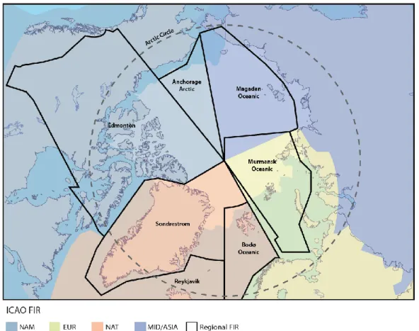
Operating drones in the Arctic poses a legal challenge, as the area spans several flight information regions (FIR), all with unique sets of regulations. The concept of FIRs is described in the “Arctic Science Remotely Piloted Aircraft Systems (RPAS) Operator’s Handbook”: “The world’s airspace is divided into eight major flight information regions (FIRs) that are designated under the Convention on International Civil Aviation [...] Each major region is divided into smaller regional FIRs in which flight information and air traffic management services are provided by ICAO Member States. [...] Six regional FIRs are of greatest interest in Arctic research (Edmonton, Sondrestrom, Reykjavik, Bodø Oceanic, Murmansk/Magadan Oceanic, and Anchorage Arctic), but Finland and Sweden may also be important to scientists” [42].Figure 9 maps the regional FIRs of the Arctic.
Figure 9. Arctic flight information regions, as designated by the International Civil Aviation
Organization. [RPAS Operator’s Handbook].
Crossing FIR borders can be problematic, as no common regulations exist as of May 2017. Inter-FIR missions must comply with all regulations of the states with jurisdiction over the relevant FIRs.
4. Using drones in arctic research
Understanding the life and activities of the arctic research stations before making any technical recommendations was essential. A thoroughly conducted user study was made in order to achieve this understanding.
The user study started with a background research about the ɪɴᴛᴇʀᴀᴄᴛ research stations and an interview with two researchers, whereof one also was a station manager. This was done in order to attain the knowledge necessary to compose a survey and interview questions of sufficient quality. Interview candidates were chosen amongst the survey respondents and their colleagues. The survey and the interviews were followed by field studies, tests and additional interactive interviews.
Interviews with drone manufacturers and a professional drone pilot were conducted to further understand how the arctic climate affects the use of drones.
4.1. Survey
The user study is partly based on a comprehensive survey that was sent to the researchers at the research stations that were active in the ɪɴᴛᴇʀᴀᴄᴛ project as of March 2017. The quality of the survey was essential to the end results and required thorough preparatory work. More information on how the survey was developed is presented in Appendix 2: the survey, together with the final survey and an explanation of its parts.
The final version of the survey was distributed on March 9th, 2017. The recipient list included 57 people, who had shared their contact information at the initial meeting with ɪɴᴛᴇʀᴀᴄᴛ in January 2017, the majority of which were station managers at ɪɴᴛᴇʀᴀᴄᴛ stations. The recipients were asked to distribute the survey to people, who they assessed to be able to provide relevant answers, resulting in a total of 29 answers from 24 different research stations.
The survey included general questions formed to gain an overview of the respondents’ working environment and tasks and the respondents’ attitude towards these in terms of willingness, exhaustion, danger and expenditure of time. The survey also examines the respondents’ attitude towards using drones in their working tasks and potential problems related to drones.
Survey results and analysis
The initial reaction to the answers was that they differed greatly between respondents. A checklist question about the types of samples/data collected, produced only unique answer combinations. The methods for collecting these samples can also vary considerably.
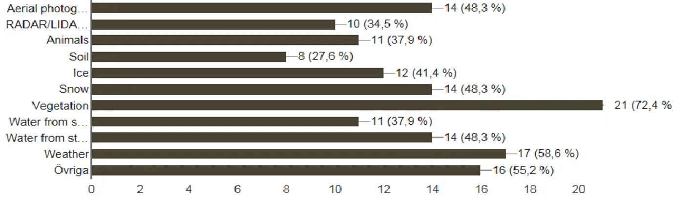
Generally, there was a broad spectrum of answers to all questions regarding the researchers work, making it hard to draw useful conclusions other than that it would be hard to find a common problem area that occurred often. This is logical considering the vastly different activities described in the station catalogue. The percentage of the different samples/data gathered is presented in figure 10.
The two most mentioned working tasks, when asked which methods the researchers experience as too dangerous or exhausting, were peet coring and transportation over glaciers. Two of the respondents also mentioned water sampling. When asking about which tasks they would like to simplify, there were no answers that occurred more frequently than any other.
Figure 10. The percental occurrence of different types of samples/data.
As shown in figure 11, the majority of the researchers had no experience or a limited experience of drones. It is also clear that most of them did not know about the technical abilities and limitations of drones. When asked to speculate freely, the respondents listed very different possibilities with drones but generally they see drones a tool for accomplishing assignments in inaccessible locations or using airborne sensors or photography.
Figure 11. Percental occurrence of different experience grades of drones.
The most common answer when asked which working tasks the researchers would like a drone to assist them with, without considering any technical limits, was remote sampling. Some of the researchers specified water sampling as a practical task to be able to accomplish remotely.
The most occurring problem that the researchers saw with using drones was that the harsh arctic weather might obstruct using them. Other problems mentioned were disturbing animals, difficulties obtaining certificates and sharing airspace with commercial traffic. Additionally, researchers worried about the price of the drone being too high.
As seen in figure 12, the majority of the respondents were positive to using a drone in their work, with a total of 55,2 percent rating their openness to the tool 10 out of 10.
Figure 12. Openness to using drones for working tasks. 4.2. Follow up interviews
Interviews were utilized in order to get deeper insights about the work performed at the stations and to complement the findings of the survey. The majority of subsequent interviews were conducted as follow-ups to survey respondents and their colleagues.
The interviewees were chosen based on their answers in the survey. When choosing an improvement area that could be solved mechanically with a drone, and delimiting from sensors and cameras, the most logical focus area based on the survey answers was water sampling. The chosen interviewees were therefore the survey respondents who had claimed to work with water sampling. “Appendix 4: Full Compilation of answers from interviews with researchers” lists their names and occupations. Figure 13 shows where the researchers were stationed at the time of the interviews.
The interview questions were individually adapted based on the answers given in the survey, and were designed to obtain more thorough information on the participants experience and thoughts on drones. The interviews also delved deeper into the survey answers regarding what the drone could be used for and the potential problems and obstacles that could occur when implementing a drone at the stations. The interviews put an emphasis on water sampling and the potential effects of drones on wildlife. The full interview guideline is presented in Appendix 3: interview guideline.
4.3. Compilation and analysis of interview answers
The conclusions in this subchapter are based solely on the interview answers and not on any scientific data. The interview candidates, who were presented in the previous subchapter, will be introduced by their full name at their first mention in each following subchapter and then referred to by surname. References for statements by the interviewees have been omitted; the interviews can all be found by the respective name in the External document: Collection of interviews. The full compilation and analysis of the interview answers can be found in Appendix 4.
What researchers want to do with drones
The interviewees were asked to expand on their survey answers. Answers from the survey question “Which of your regular tasks (if any) do you think could be aided by the use of drones? (Research and non-research related)” were used to spark a discussion.
Some researchers would make use of the drone without any modifications to the standard-equipped vehicle. It is possible to use a standard RGB camera, that is often included in the more advanced off the shelf drones, to gather considerable amounts of information needed by researchers. For example, it is entirely possible to extract Normalized Difference Vegetation Index [43], an indication of the amount of living vegetation in an area, from standard RGB photographs [44]. Another use for the standard camera, coupled with the right software, is charting animal populations and vegetation density, which is an area of interest for many arctic researchers.
Another highly interesting use area of drones is equipping them with different sensors and the scope of what can be accomplished with sensors on drones is wide. Some of the interest areas for arctic researchers to examine with sensors on drones are concentration and greening of vegetation, soil moisture, water depth, mass budget of glaciers, temperatures at inaccessible locations and animal charting. For example, RFID (Radio-frequency identification) systems can be used to supervise reindeer. The system utilizes to find and identify reindeer. The reindeers’ tags are passive, which eliminates the need for batteries or other maintenance, but limits the range of detection to 200-500 meters. Flying in such close vicinity to animals is not feasible with traditional aircraft, but drones make this possible.
Paul Eric Aspholm expands on using drones for animal charting: “Drones are fantastic instruments. You can use them to fly up and get an overview of the terrain and the activities of reindeer, bears, and other animals. Not to mention birds! In the wetlands, you scare the birds by walking around. With a drone, you can get an overview; you can position yourself above the forest and scan the water surface from there.”
Another area of interest is using drones for field safety checks and search missions. Drones have a risk-reducing potential which is sometimes needed since the climate and the terrain that the researchers work in can sometimes include somewhat dangerous elements or be conducted in rough terrain, although most research projects are designed not to.
Gunhild Rosqvist explains how a dangerous working task of the arctic can be conducted: “During the summer you need to be four people tied together with rope to measure this. You are not risking your life, but you are submitting yourself to a high risk every week. It is incredibly intensive work.”
Drone data can be described as a good middle ground between plot data (i.e. manually collected field data) and satellite data; one is limited in coverage (within a set time span) and the other in resolution. Drones offer a new ratio of coverage/resolution, and by doing so, they may fill a so-called scale gap. The researches welcomed this increased data resolution. The positioning of UAV imagery is illustrated in figure 14. The figure featured in a lecture by interviewee Johan Olofsson.
Figure 14. Scale of UAV imagery (right bar) compared to other data collection methods
[UAS4S Conference 2016].
Drones can also be used to physically place sensors or trace elements at locations that are inaccessible or dangerous to reach by foot.
The researchers saw the drone as a complement to their practiced methods, rather than as a replacement. Replacing work tasks with drones is a “niche” field, and the main research implementation of drones will be more about expanding the range of activities and finding new tasks.
Eefje De Goede expands on drones as a complement: “Well it could replace work over time, but there will always be other things that you can only do on the field. It just allows you to cover more ground I think and to monitor more frequently, which is just not possible with the field work.”
Magnus Augner agrees: “I mainly see this as a complementary system. Drones can do things that you do not have the time and money for today. The most important things is that new methods for data collection are being put to use.”
Collecting data more efficiently could possibly help save researchers’ time, and subsequently allow research projects to be more extensive using the same (or less) resources. Larger amounts of input data may also improve the accuracy of the research results. Several researchers saw potential in mapping areas autonomously and more frequently.
Hlynur Oscarsson saw interesting opportunities in the ability to repeat flight patterns and claimed that “Traversing over large wilderness areas can be very difficult and if you have a drone you could fly over them at low elevation and gather considerable amounts of data. Some of these are huge areas and having a drone that could detect and fly in the same pattern every two or five years could give you a really good estimate of the vegetation.”
Some research work makes use of helicopters. Some aspects of a helicopter, such as airborne collection of imagery and sensor data can be managed by a drone, while others, such as transportation of people or heavy equipment, cannot. It is worth noting that it is fairly common to discuss the subject of noise generated by drones. This is of course a relevant factor to consider, however, the noise levels are more often compared to silence rather than to the noise levels of helicopters. The main concern with using helicopters is the high price and researchers believe that drones could accomplish the same tasks, if it is possible to acquire small enough sensor systems.
Difficulties with drones
The researchers had their doubts about using drones. One concern was the effects of weather and the interviews reveled that, in the eyes of researches, drones can be referred to as a “nice weather system”. Winds were brought up the most frequently as a weather-related concern. Unless specifically equipped to compensate for strong winds, drones may be hard to control. However, controlling the drone is merely one of several issues caused by wind.
Johan Olofsson had an example of how drone documentation and ortho-mapping is affected: “The main issue is that the subject is moving when you are taking the picture. Problem arise when you want to combine the photographs using algorithms. Individual photos are fine, but it is difficult to use them for landscape modelling when things are moving in the wind.”
The weather in Arctic and subarctic locations is often a limiting factor when it comes to attempting excursions and field testing. This is an aspect to consider when discussing how the use of drones is limited by weather. As a reference, the researchers at Tarfala Research Station
mentioned that they had only managed to complete two field days over the course of their five week stay.
Aspholm claimed that he was able to use drones during about one quarter of the days at the station, even though he described the drones as rugged and somewhat water resistant. Aspholm also had reservations concerning drone dependency, and described a scenario in which he promises results but are unable to deliver due to the drones inability to operate in poor weather conditions.
Many researchers seemed to be aware of the effects of low temperatures on the capacity of lithium batteries. They were concerned that this would be limiting in the field. It is worth noting that, as will be described by the two drone manufacturers in chapter 4.7, if the battery is stored in an insulated environment until take-off, it will retain that heat due to heat losses that occur when a current is drawn by the drone (due to the battery’s internal resistance).
The skill level needed to be a competent drone pilot is also something that concerns a majority of the researchers. Many would like training before getting responsibility of a drone. Most interviewees were interested in the technology, but lacked the practical experience of piloting a drone.Lack of experience, both on an individual and a collective, researchers’ level, makes it difficult for the interviewees to know the capacity and commercial market of drones. The interviewees, as well as comments from other researchers, indicated that they were awaiting both a more mature drone market and for someone else to implement drones in a manner relevant to them.
Another concern with drones is the added expense of owning and maintaining one. Drones, like all technical instruments added to an operation, can cease to function and become in need of repair. Some elements, for instance propellers and other moving parts, are meant to be replaced on a regular basis. Batteries also have limited life spans. These are added costs associated with drone ownership.
Some drones are partly operated via on-screen interfaces. This is the case for the DJI Phantom series, which uses a non-proprietary screen and a mobile app to display certain flight data and a live stream of the on-board camera’s view. This can be problematic in some settings where the bright light and reflective snow makes the screen’s backlighting appear dim in comparison. Coupling that with a pair of glasses and sunglasses and the screen becomes too dark to rely on. Besides visual ergonomics, ergonomic issues were reported with the small size of the joystick and with handling small buttons while wearing gloves.
Practical aspects of piloting a drone
All of the interviewed researchers think that practice is necessary in order to operate a drone in a mission setting.Some would like formal training in the form of a drone operations course. Such courses are sometimes provided by the retailer, usually with the purchase of a more advanced drone system. For example, Olofsson mentioned that, included with a purchase of a 150-170 kSEK drone system, hereceived training for two days and a certificate.
Besides serving as a training and knowledge resource, a drone-operating course may be required in order to attain the proper certificates and licenses to operate a drone. These vary based on the territory where the operation takes place. Many of the interviewees are concerned with the difficulty in obtaining the licenses and some adapt their choice of drones in order to avoid the licenses that are harder to obtain.
The cost has been highlighted as one of the main reasons not to invest in a drone system. The true cost of the system is dependent on more than just the retail price. As an example, Olofsson motivates his relatively expensive drone purchase, with the high cost of qualified personnel: “Employing a person with a monthly salary of 50 kSEK would cost approximately 100 kSEK. If that person would do all the research, prototyping, software development, and post-processing solutions that went into making his 150 kSEK drone system, it would likely take the person longer than two months, effectively making it more expensive to reach the same capacity with a “homemade” system.”
Another price factor is the effect of the drone system on efficiency. Not having to trek to test sites on foot to collect data would save a lot of time. Reducing the time researchers spend on data collection would allow them to spend more time engaged in more qualified work. The potential in saved man-hours is difficult to estimate but can be worth multitudes more than the cost of a drone system.
Helicopters are sometimes used by researchers to carry sensors over areas of interest but they are generally very expensive, some interviewees believe that it would be a lot cheaper to find a sensor system small enough to be carried by a drone.
Some researchers are interested in using fixed-wing drones, but are concerned that their stations lack the infrastructure needed to operate fixed-wings. They believe that a runway is needed for takeoff and landing. However, it is worth noting that fixed-wings can be catapult-launched for take-off and parachuted down for landing. These methods did not seem to be known among the interviewees.
Svalbard, Norway, is home to many research stations and researchers of different nationalities. At Svalbard, all the research programs must be registered in the Svalbard database and the researchers have to get permission from the [Norwegian] government for all the research that they want to conduct. It is difficult to say whether or not the use of drones would complicate this approval process of Svalbard missions.
Parts of Svalbard are subject to a frequency ban. The 2,1-2,5 GHz bands are reserved within a 20-kilometer radius of the very-long-baseline interferometry station at Hamnerabben. De Goede reported that her department modified store bought drones for Svalbard use, replacing the standard 2,4 GHz controls with 35 MHz controls.
A location being remote is not a guarantee of a free airspace. As an example, Augner talks about communicating within the shared airspace of Abisko, Sweden: There is a lot of helicopters in the area [...] It is easy to keep track of the companies that fly, it is simply about contacting them in advance [of flying]. The problem is if I want to fly above 50 meters and don’t have the drone in my sight. Then it becomes extremely important to have preemptive communication with the helicopters.”
Another practical issue to consider when using drones in arctic environments is that the cold climate forces the researchers to wear gloves, however, standard RC controllers are difficult to operate while wearing gloves. Transparent hand warmers (muffs) fitted for drone controllers are sold for this purpose, although they often do not accommodate the external screens utilized by some consumer drones (such as the DJI Phantoms).
![Figure 1. The locations of the stations involved with ɪɴᴛᴇʀᴀᴄᴛ [ɪɴᴛᴇʀᴀᴄᴛ].](https://thumb-eu.123doks.com/thumbv2/5dokorg/4592263.117999/12.892.174.722.534.1095/figure-locations-stations-involved-ɪɴᴛᴇʀᴀᴄᴛ-ɪɴᴛᴇʀᴀᴄᴛ.webp)
![Figure 3. The island where the FINI is located [ɪɴᴛᴇʀᴀᴄᴛ website].](https://thumb-eu.123doks.com/thumbv2/5dokorg/4592263.117999/13.892.256.639.824.1112/figure-island-fini-located-ɪɴᴛᴇʀᴀᴄᴛ-website.webp)
![Figure 5. Global number of drone units sold 2013 – 2015 [dronelife.com].](https://thumb-eu.123doks.com/thumbv2/5dokorg/4592263.117999/17.892.192.712.830.1102/figure-global-number-drone-units-sold-dronelife-com.webp)
![Figure 6. Promotional picture for the DJI Phantom 4, displaying the mobile device/RC transmitter control setup [DJI].](https://thumb-eu.123doks.com/thumbv2/5dokorg/4592263.117999/18.892.151.737.287.547/figure-promotional-picture-phantom-displaying-mobile-transmitter-control.webp)
![Figure 8. Acquiring “operation authorization” with forthcoming EASA regulations [Rémi Vesvre].](https://thumb-eu.123doks.com/thumbv2/5dokorg/4592263.117999/24.892.169.718.577.877/figure-acquiring-operation-authorization-forthcoming-regulations-rémi-vesvre.webp)

![Figure 14. Scale of UAV imagery (right bar) compared to other data collection methods [UAS4S Conference 2016].](https://thumb-eu.123doks.com/thumbv2/5dokorg/4592263.117999/30.892.126.775.464.1047/figure-scale-imagery-right-compared-collection-methods-conference.webp)

