Scientific Press International Limited
The Abbasids and Tigris Irrigation Canals:
The Nahrawan
Nasrat Adamo1 and Nadhir Al-Ansari2
Abstract
The irrigation of the Sawad lands which depended on the Tigris River are presented as the subject of this paper. In this paper one of the largest irrigation systems, not only of the old world but even today is described; this is the Nahrawn Canal System which irrigated the whole alluvial lands east of the Tigris extending as far east as the foothills of Persia and from Al- Dur above Samarra towards the south for almost 300 kilometers. From the archeological findings and historical writings, we know that this system had existed for thousands of years. The construction of the old Nimrud dam on the River Tigris was associated with the excavation and construction of this canal, and they were both attributed to the days of Hammurabi the famous king of the Chaldeans which had been mentioned previously although the canal may have been excavated in many stages and by successive kings. The canal and its whole systems were kept in good operational conditions by the successive empires who ruled the country as agriculture in this vast area of land had depended entirely on its water supply. The revenue drawn from this agriculture was a major part of the income of these empires which had fueled their progress, prosperity and their wars. Full description is given of the canal itself and the two feeder canals which had supplied it with water from the Tigris south of Sammara. The third feeder excavated by Khusraw Anushirwan which took off from al- Dur north of Tikrit which was called Katul Kisrawi is also described. More canals which were associated with the Nahrawn Canal such as al- Qawrach and Nahr abu el- Jund are detailed with the circumstances that led to their construction. The trunk canal course and the two massive gravity dams, which served as diversion structures on the Adhaim and Diyala Rivers are described, which were obstructing the passage of the course of the canal. Maps and sketches also supported these descriptions. The towns and settlements along the course of al-Nahrawn Canal are detailed with
1 Consultant Engineer, Norrköping, Sweden.
2 Lulea University of Technology, Lulea, Sweden.
Article Info: Received: February 10, 2020. Revised: February 15, 2020.
descriptions based on the writings of the Muslim geographers of the Abbasid period who had reported in length about the canal and the state of the country it had served. The canal was also the main source of water supply to the eastern quarters of Baghdad, which had stretched over considerable area during the days of Khalifah al- Mansour and the following Khalifahs. The distributaries of the Nahrawn, which served the eastern quarters of city on the right side of the Tigris, are, therefore, described in details and the dense network of the secondary canals and watercourses branching from them to serve the various quarters of the city are given full attention. In addition to this, the notes and sketches that were made by two British travelers who travelled along the whole course of the canal in three separate occasions at the end of the nineteenth century are documented with their remarks and notes. In addition, the comments of Sir William Willcocks, the famous irrigation British engineer of the same period, are also added. In summary, the story of one of the greatest engineering achievements of the old people of Iraq in addition to narrating the events that led to its decline and final collapse during the last period of the Abbasid Khalifah.
1. The Abbasids -The Nahrawan
The Tigris River, in a similar way as the Euphrates, supplied Iraq’s al-Sawad with abundant amounts of irrigation water.
The geomorphology of its valley as it entered the delta, however, controlled the way of how water was drawn from it and how irrigation was affected. The frequent shifting of its course during history had also its impact on the major canals off taking from it and the locations of these off takes. This was evident from the old history of the Nahrawn Canal, which branched from the left side of the Tigris, and the Dujail and Ishaqi canals branching from the right side of it.
The history of the great Nahrawn Canal is very old, and this was explained in paper (3), it is thought, depending on archeological findings, that its origin went back to about 2000 BC. This great canal and its network of branch canals and watercourses continued, however, to serve its purpose until the decline of the Abbasid Khilafa, when due to negligence and lack of maintenances its conditions deteriorated; and in the following wars and conflict was destroyed and abandoned.
The Nahrawn Canal is known from its remnants today, and from historical writings, whereby it had branched from the Tigris River downstream from Tikrit, had taken a southeasterly direction and crossed the present course of al-Adhaim River upstream from the confluence of this river with the Tigris. Whether it was itself, an old course of the Tigris River is something that needs an elaborate study and more archeological and geological investigations. In its known course, it continued to run in southeasterly direction for a long distance until it reached the Diyala River, where archaeological evidence indicates that the river, itself was diverted into many canals which served irrigation to the east of its course direction to allow the passing of the Nahrawan canal across it while its original course became a drain.
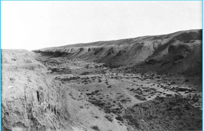
In total, the Nahrawn Canal extended for 225 km from its beginning above Sammara to the southeast of Baghdad at the outskirts of Kut, Figure 52[1]. One
photograph taken of the remnants of the Nahrawn Canal, at a location south of Samarra by the well-known British Oreantalist Miss Gertrude Bell in 1909 is presented in Figure 53.
This photograph shows the canal grandeur even after its abandonment and its decay since more than eight hundred years. To give as detailed an account of the long
route of the canal as possible, it is endeavored here to do the following: First: describe it from its point of origin all the way down to where it crossed the
Diyala River at the old Diyala Dam site, a reach which many authors had given it different names, such as the Upper Katul, Al Qaim or the Nahrawn;
Second: follow the lower reach of the canal from the site of the old Diyala Dam site down to where it ended in the Tigris River close to Jarjaraiyeh. Some authors called this reach as the Nahrawn, but others called it Tammara; which was the old name of the Diyala River itself. For our purpose, however, and to avoid confusion, the name Lower Nahrawn, or just the Nahrawn will be used.
Along this long route, many large distributaries had branched from the trunk canal to irrigate every piece of land in the vast area east of the Tigris helped with the flows of the Adhaim and Diyala Rivers, which irrigated the remaining lands not within its command. The course of the canal as illustrated in Figure 52 shows its extent and some of the major towns it served. The canal originally had two head reach canals before digging another upper one by the Persians, which was called the Upper Katul. Many impressive engineering works were also built to extend the service of the canal and cover most of the Sawad lands at the east of the Tigris River.
Figure 53: Photograph of the remains of Al Nahrawn canal taken by the British Oreantalist Miss Gertrude Bell at one location south of Samarra in
1909, Bell (1909)[2].
In accomplishing these works, the engineers had done many reconnaissance works and made use of topographical features such as depressions and older river courses in order to extend the canal for such a long distance. They had also thought of, planned, and executed all necessary works to ensure the canal continuity and flood relief works related to it, in addition to the vast irrigation canal networks covering
all the lands that the canal had served along its long course. Judging from the size of this great work, it can be assumed that it must have taken
tens, if not, hundreds of years to complete, and this accomplishment was made possible by utilizing the manpower of thousands of slaves and prisoners of war, that were normally taken in the big battles of those times. This indicates clearly that such works could only be done by the “Victorious”.
It is a well-known fact from the history of the Nahrawn Canal that, it was preserved in good working conditions during the Sassanid times and, except for very short periods during wars and disturbances. The Sassanid kings knew very well the value of the canal and the enormous income it contributed to their treasuries. Therefore, they saved no effort in maintaining its network of canals. The same applied to the Khalifahs of the Abbasids during the Khilafa’s golden era, who contributed a great
deal in its improvement and extension for the same reason. Unfortunately, however, it was progressively abandoned from the mid-10th century onwards; which mirrored the Abbasid Khilafa's decline. The canal, henceforth never had the chance to be revived by the foreign powers who occupied this land.
Geographers who travelled over this area in the middle of the 19th century witnessed to the fertility of these lands, as they observed this in the localities irrigated from the few small existing canals at this time. Otherwise, the vast remaining areas once been deprived from their irrigation supplies turned to barren and empty lands, mostly inhabited by the roving Arab nomads with their animals. Their sheep flocks, grazing at the meager grass that would grow after the rain showers of winter, or at best they grew grain in the deep beds of some short reaches here and there of the abandoned canal where the wetted earth had been soaked by the water pools left from these showers. Contrasting this bleak picture with the shining and lively one given by the Muslim Scholars of the 9th and 10th century, who described the greatness of the canal and wealth it bestowed on the population, one cannot but feel sorry and sad at the same time of the turn of events that led to this situation. One would also wonder; was it a misfortune that the wealth of this region was always tempting invaders to reach for it? Or was it because it was a theater of conflicts between foreign forces who settled their accounts on it?
Indeed while all these were good reasons, the main ones actually were the indifference and slackness of the people themselves brought about by too much prosperity, which was the case in the late Abbasid period.
From the chronicles of Dr John Ross, a medical doctor who was attached to the British Residency in Bagdad, which were published in the Journal of the Royal Geographical Society in 1841, and were related to his journey in 1834 along the route of the Nahrawn Canal from Baghdad to Sammara; he gave a vivid description of what remained of this canal. He even spoke of the amazing fertility of one tract of land, originally irrigated by the canal, but was being irrigated then by the Khalis Canal, where he says:
“I never saw the effect of irrigation better marked than in this day’s march: as far as the branches of the Khalis are carried on both sides of the parent trunk, all is green, and the soil was remarkably rich, while beyond it, on either side, there is nothing but arid desert, entirely destitute of any vegetable production”[3].
The head works of the great Nahrawn Canal were associated with another, very impressive engineering work; namely the “Grand Nimrud Dam” which was located some kilometers below the spot where the Tigris entered its delta.
The massive earthen Nimrud Dam barred the valley, during much earlier times, and the river turned over the hard conglomerates, so that it could flow at a higher level and irrigate the country on both banks. In the words of Sir William Willcocks, the
late nineteen-century British engineer he sated; “The construction of the Grand Nimrud Dam and the Great Nahrawn Canal
involved colossal volume of work and great deal of planning and surveying works. In considering the size of the “Grand Nimrud Dam’, we should remember that this dam had to be of such volume and workmanship as to resist Tigris floods which
from hydrological calculation can reach up to 12000 m3/second. The dam continued to function for about three thousand years, and its destruction and progressive abandonment lasted from the mid-10th century onwards mirroring the Abbasid Caliphate's decline”
Sir William Willcocks, who had studied the irrigation of Mesopotamia for the Ottomans, also added:
“The Great Al- Nahrawn Canal was the greatest and grandest of all irrigation canals of the ancient times that we know of today. It had extended for 300 kilometers and supplied water to an area of 80,000 square kilometers of irrigated land. Its discharge must have been between 250- 300 cubic meters per second. From the remains of the canal, it must have had a width of 120 meters in some parts and a depth of 12 meters” [4].
According to Willcocks, the Nahrawn Canal must have helped a great deal in the
relief of the Tigris River floods. In the description of Ibn Serapion of the Nahrawn Canal during the Abbasid time,
he informs us that the canal branched from the Tigris at a point south of Tikrit, to the north of Sammara, a short distance below Dur- al- Harith, where the city of Dur
exists today, see Figure 52. Down to the place called Qanatir (el Kanatir) the canal was called the Katul
al-Kisrawi.
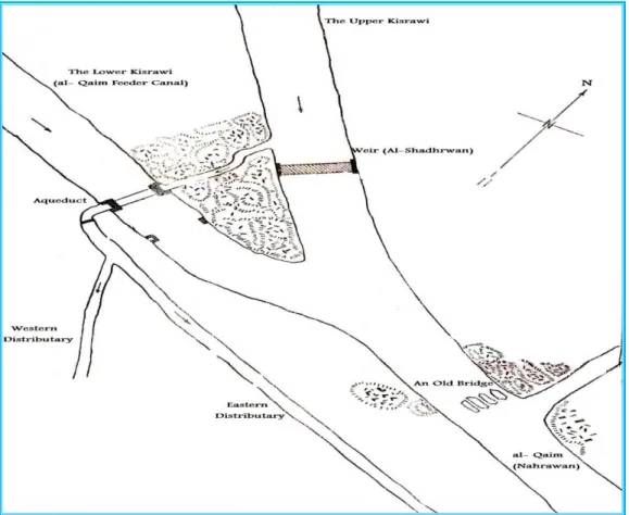
Moreover, the canal had also two additional head reach feeder canals from the Tigris located south of Sammara for the obvious reason of providing the flow with the required command over the irrigated land during high flow and low flows seasons. These head reach canals, or Katuls, according to Ibn Serapion, had the names of al-Yahudi, which ran for a short distance before joining the second head reach feeder canal called al- Ma’muni to form the canal under the same name.
The al- Ma’muni, which passed many villages and fertile domains, finally met with the Katul- al Kisrawi below the village of al- Qanatir. One large weir was constructed at the confluence of the two canals which was called Ash-Shadhurwan, which was obviously built to raise the level of water in the canal for better command over the irrigated lands. Twenty kilometers below this point the town called Sula
or Salwa was located [5].
A new feeder or Katul was dug later on by the Khalifah Harun al-Rashid, which was called Abu- al-Jund, and this canal was a very large canal, which had the best-cultivated land along its banks. Many distributaries branched from it and irrigated the lands laying a considerable distance to the east of the Tigris and even south of Baghdad.
From ibn Serapion writings, LeStrange [6] quoted the following:
“The third canal was called Abu- al-Jund (Father, or Supplier, of the Army) from the fact that the crops raised on the lands watered by it were used as rations for the troops. It was the largest canal of the three, and had been dug by Harun al Rashid, who built a palace there while superintending its construction”
Sousa, however, in his book on the irrigation of Sammara [7] speaks of different
name of the second feeder “el- Sanam.” After the merging of these two feeders the main canal continues, according to him, bearing the same name of (al- Qaim) until it joins the Katul Kisrawi near al- Qanatir (Kanatir).
Dr Ross, however, wrote in his chronicle mentioned already, that the above names were the names used by the local people at his time, which explains why these were not mentioned in the writings of the 9th and 10th centuries Muslim scholars who wrote on the Nahrawn Canal. Dr. Ross presented also a sketch of the remnants of
these feeders, which were mapped by him in 1834, Figure 54 [3].
Figure 54: Dr Ross Sketch of the feeder canals of the Nahrawn Canal [3]. Dr Ross, in his description, which was based upon the narrative of his local Arab guides; the “el Sanam” off take was close to the location of an immense statue called by the locals (el- Sanam) or (Idol). The top of which was removed previously and taken to Baghdad by another British traveler called Colonel Taylor, but the lower half being buried under the ground was left in the place. A recent work performed by a British archeological expedition in surveying and digging up of Sammara archaeological sites and published in 2007 the same site was examined and surveyed, and the results are shown in Figure 55 [1].
On the courses of the Katul Kisrawi and the other feeders many masonry bridges of arches were built to facilitate the crossing of people and animals or passing the flow of one canal over another as aqueducts to irrigate more land on the other side. The people would have called these bridges and aqueducts properly as Kanatir at those times, while weirs, which may have also carried crossing over them would be called Shadhurwans.
According to ibn Serapion, the Katul Kisrawi assumed the name “of al- Nahrawn as it passed through the city of Jisr al- Nahrawn, but it was named “Tamarra” just below Ba’quba, which brings again the problem of nomenclature mentioned earlier.
Figure 55: Area south of Nahr al Qaim showing el-Sanam feeder below it and the Qadissyia fort in between them [1].
Compared to the Nahrawn or Tammara, the Katul Kisrawi did not exist in the early history of the Nahrawn Canal, but it was excavated later by the Sassanid King Kosrow Anushirwan (531-579 AD), so it was named after him as the “Katul Kisrawi,” while its remnants exist today under the name “al- Russasi”.
The “Katul Kisrawi” stretched from its intake on the Tigris just below al-Dur for 65 kilometers until its confluence with “al- Qaim” feeder canal forming the main Nahrawn canal or the “al-Qaim” as Sousa called it.
The dimensions of “Katul Kisrawi” were 20-25 meters in width and 10-12 meters in depth in the first 25 kilometers, then it widened to up to 100 meters with depth of 2-3 meters in the remaining reach. After merging with the “al- Qaim” canal
aforementioned, the combined canal widened even more. The “Katul Kisrawi” irrigated all the lands extending below its intake, on the left
bank of the Tigris and the orchards of the present city of “Balad.” These lands were densely populated and permanently cultivated and were called Tusuj Bazerchsabour (meaning Bazerchsabour districts). It is interesting to note here that, the administrative system used by the Sassanids for the purpose of land management, canal`s maintenance and tax collection, was also adopted later on by the Abbasids for the same purposes. In this system, the smallest administrative unit was designated by the name “Rustaq,” which covered few hamlets or small villages, then the “Tasj,” the plural being “Tusuj,” which contained many of the rural
Available evidence indicates that the canal network for irrigate these lands used the summer discharge of the “Katul Kisrawi” completely. It was even necessary to construct one large weir or “Shadhurwan” just before its confluence with “al- Qaim,” very close to a large village called Al- Mamuniyya to raise the level of water in the canal during summer and get the required command for all the remaining part of the network. In many writings, this was also called the “Upper Shaderwan” to differentiate it from another similar weir that was called the “Lower Shadhurwan” on the lower reach of the canal at “Aberta.”
In 1849, Commander Felix Jones, who was employed by the East India Company, surveyed the location of this structure. Later, he conducted important archaeological surveys of parts of Mesopotamia, including the course of the Nahrawn Canal. His account of it was included in his detailed narratives, which were published in three articles that were kept in the records of the British Bombay Government [9].
Jones started his reconnaissance from Kut in April 1848 to look for and examine the remnants of the many branch canals that took off from the Nahrawn which irrigated the tract of land to the north and north east of Kut, and further to establish the route of the trunk canal itself south of the Diyala River. He then continued the reconnaissance of the course north of the Diyala River in March 1849.
Jones narratives are considered today to be very illustrative of the canal conditions in the middle of the nineteenth century, and they contained in addition description of the canal during its glorious times, basing this on the observations writings of the various Muslim Scholars of the 9th and 10th centuries who wrote on the canal. In Figure 56, which is extracted from this publication, the confluence of the Katul Kisrawi and al- Qaim is shown, indicating the location of the “Upper Shaderwan” or weir.
A sketch of the same was given by Sousa in his book on the “Irrigation of Sammara”
Figure 56: Sketch showing the confluence of the Katul Kisrawi and Ghaim (Qaim) as surveyed by Commander Felix Jones [9].
Examining the site at the confluence of “Katul Kisrawi,” and “al- Qaim,” where this structure was located, Jones reported that, in fact there was a second dam on “al- Qaim”. This dam was located about a quarter of a mile above the spot where the two canals united. Apparently, it was destroyed, probably to use its material in building the nearby Khan Doloiyeh town. The remnants of the structure indicated that it was of masonry construction built from very large kiln burnt clay bricks; these bricks were square shaped having a side length of sixteen inches, and four and half inch thickness. The length of the dam measured about ninety feet, and was some twenty feet in width. A sixteen, inches thick layer of very durable and of superior quality concrete covered the surface of the weir. It was to protect it from the abrasive action of the current.
The two weirs were meant to raise the water level to feed the branch canals upstream when the main canal became too deep, and at the same time reduce the velocity of the flow protecting, therefore, the canal bed from scouring, and the bridge weirs
Figure 57: Sketch made by Felix Jones (1846), and modified by Sousa, of the remains of the Weir and other features at the confluence of the Upper Katul and al-Qaim Canal (nomenclature is translated from Arabic to English by the
writer).
Opposite the location of the bridge, on the left side of the Nahrawn, there Jones took note of a mound called by his Arab guide “Tell Mahasill.” He thought that this was either a landmark for the caravans seeking the crossing location, or maybe it was covering the ruins of a tall building that was used as customs or toll house.
From the extensive ruins between the two arms of the canal, which extended to fair distance, upstream Jones argued that these ruins may have belonged to the ancient
city of Opis.However, historical evidence shows that Jones was wrong. Opis was
an Ancient Babylonian city on the right bank of the Tigris. Akkadian and Greek texts had also indicated that this town was located on the west side of the Tigris near its confluence with the Diyala River. The precise site of the city has been considered uncertain for a long time. Recent geographical surveys of ancient Mesopotamia identify Opis with great probability as the mound called “Tell al-Mujailāt (or Tulūl al-Mujaili`)” which is located thirty-two kilometers southeast in a straight line from central Baghdad very close from Ctesiphon, and seventy-six kilometers northeast in
a straight line from ancient Babylon. One more error seems to have been made by Jones; for in Figure 56 the left hand side branch canal he had called “Nahr al Batt” canal, while “Nahr al Batt” canal actually branched from the right hand side of the Nahrawn at a further point downstream, which corresponded to the site of the al-Adhaim dam;. Sousa seemed to have been aware of this mistake and so he did not attach any name to this branch in his sketch shown in Figure 57.
In the older history of the Nahrawn canal, and as mentioned already the third and uppermost feeder canal, namely, “Katul Kisrawi” did not exist, but it was dug later on by Kosrow Anushirwan to irrigate more lands, which were located above the al- Qaim feeder canal. This action led to the reduction of flow at the lower reaches of the canal. As the “Katul Kisrawi” was drawing more water in summer, which had caused the lowering of the Tigris River water level upstream the al-Qaim feeder canal and deprived it from much of its original discharge during this season. Shortage of irrigation water was very severe in the districts around where the eastern quarters of Baghdad were built later on. Prompted by the complaints of the farmers of the affected districts, Anushirwan closed the intake of al- Qaim completely and dug a new canal to the south of it which was called in the Arabic literature by the
name “al- Qawrach” [10]. The exact location of this canal intake below al- Qaim is
not exactly known; but the Tigris River may have obliterated its remains when it changed its course later on towards the east.
It is estimated, however, that it could have been at a point ten kilometers northwest of the present city called Balad. The course of Al- Qawrach traversed then a distance of about eighty kilometers until it joined the Nahrawn canal. Along this course, many distributaries and watercourses had branched from it to irrigate the lands on the left of the Tigris, which were irrigated previously from by al- Qaim. From the large number of these watercourse`s records mention some of them such as Khait Ahmad, al- Mansur, Khait Abi Jarad, Khait al Majbura, Nahr Al jath, Nahr Abi Rumail and many others.
Later on, during the Abbasid time, the Tigris River shifted its course as mentioned occupying the upper reach of “al-Qawrach” itself, which caused the shifting of the canal intake downstream for about fifty kilometers. In this new location, the new intake began to draw excessive quantities of water during the floods of the Tigris River causing the frequent inundation of the area east of Bagdad, and endangering the eastern quarters of the city itself. For a solution, the Khalifah Haroun al- Rashid (786-806 AD) ordered the closure of the intake of “Al- Qawrach” canal and the reopening of the closed intake of the “al- Qaim.” At the same time, he saved no effort in dredging the canal from the old silt accumulated in it previously and improved its course, and so it became to be known as “Nahr abu- l- Jund” as mentioned earlier.
For all these times, the Nahrawn canal remained the main source of irrigation water for the vast tract of al-Sawad lands in the eastern side of the Tigris River all the way from Tikrit to Kut. The establishment of Baghdad, the capital city of the Khilafa, at the heart of this area gave the canal more weight, as it became at the focus of the Khalifahs’ attention.
After the building of the round city by al- Mansur, the eastern quarters of Baghdad started to develop rapidly on the left bank of the Tigris. These quarters were supplied by water from the canals which branched from the Nahrawn in a similar way as the canals from the Euphrates supplied the round city and the western quarters of Baghdad.
The start was after al- Mansur had decided to leave his palace in the Round City and lodged in his new palace “al Khuld’ which he had built just outside the Round City very close to the bridge taking the Khurasan road across the river on the left bank. He at the same time undertook the building of “ar- Rusafah” on the eastern bank, exactly opposite to “al Khuld’ palace. The “ar- Rusafah” included a grand palace for his son “al- Mahdi”, spacious gardens, large park, and a military camp for al- Mahdi’s troops with their review ground (Maydan); at this time “al- Mahdi” and his troops had just returned from ar- Rayy in Khurasan in 151AH/769 AD and they were in need for such an encampment. A protective wall and a moat surrounded the site of al-Mansur’s heir and an important military site, “ar- Rusafah”. Its suburbs outside the wall grew quickly as people began to move in especially the nobles who started to build new palaces and the commoners who found room for building their homes. These suburbs were “al-Shammasiyah” to the north, and “al-Mukharrim” to the south. All the three quarters became the forerunners of the modern city of Baghdad.
The small village “Kalwadha” south of “ar- Rusafah,” where “al- Karada” quarter of modern Bagdad is located nowadays, also flourished.
The Round City remained the seat of government until Khalifah Muʿtaṣim moved it to Sammara in (836 AD) which remained as the official residence of the Khalifah until (892), when Mu`tadid re-established Baghdad again as the Capital. In al-Mu`tadid reign the seat of Khilafa was fully established in “ar- Rusafah,” on the eastern bank of the river and so, “ar-Rusafah” and its suburbs grew to rival the Round City with its increased population and many grand palaces, mosques, and markets.
The lands of al-Sawad east of Tigris had been under irrigation from the Nahrawn canal branches since the Sassanid times and even before, therefore, two of these branch canals namely Nahr Khalis and Nahr Bin had covered the requirements of the lands around the eastern quarters of Baghdad and the city itself before they
poured out into the Tigris River. Nahr Khalis` intake was probably at a point near
the town of “Bijisri” on the Nahrawn close to “Ba’akuba”. It flowed then a considerable distance before it poured into the Tigris at Rashidiyah, a short distance above Baradan, which gave one of the city gates its name and was located about
three leagues (14.5 km) to the north of Baghdad.
Nahr Bin, on the other hand, bifurcated from the Nahrawn Canal at a short
distance from the bridge of boats at the town of Jisr al-Nahrawn, and flowed out into the Tigris about two leagues (9.7km) below Baghdad at “Kalwadha”.
One important branch of Nahr Khalis at its lower reach was called the
“Nahr-al-Fadhl” supplied a network of watercourses covering the needs of “ar- Rusafah” and “al-Shammasiyah” quarters before it ended in the Tigris River.
The watercourses bifurcating from Nahr-al-Fadhl assumed different directions passing between the gardens and palaces at these quarters, ending either into the
“Nahr-al-Fadhl” itself or into the Tigris. The first of these watercourses was called “Nahr-al-Ja’fari” whose point of origin was at some distant north of Shammasiyah Gate. Then after it had run passing many villages and irrigating the tract of land north of the city its water was dissipated completely, but not before it had given out an off shoot canal, which was called Nahr al- Sur (the canal of the wall). This new watercourse flowed along the wall of the city and passed the gates called “Bab Khurasan” and “Bab- al Bardan” before it poured out back into the Nahr-al-Fadhl, which itself flowed out into the Tigris at the gate of “Bab- ash-Shammasiyah.” The next canal, which bifurcated from “Nahr-al-Fadhl,” very close to Shammasiyah Gate, was called “Nahr al Mahdi,” which having passed this gate, it entered Baghdad by “Bab –ash-Shammasiyah” and flowed to the market called “Swaykat Ja’far”. Emerging from “Swaykat Ja’far” this canal passed then by the road of Nahr Mahdi until it reached the bridge called “Kanatir- al- Bardan” whence
it entered the House of the Greeks or “Dair- al- Rumiyyin”. From here it passed the
market called the “Suwayka Nahr- ibn Malik”; and next entered “ar- Rusafa”, where it came to the Great Mosque, and to the garden called “Bustan Hafs” where it finally ended into a tank (Hawdh) located in the interior of the palace of “ar- Rusafa.” One watercourse branched from Nahr al Mahdi,which passed then in the “Market of Nasir” at the Iron Gates “al- Abwab –al- Hadid”; it flowed along the center of the road of the Khurasan Gate, flowing finally into the Nahr as-Sur aforementioned.
Two more watercourses branched of the Nahr al Mahdi itself, which made a loop before they met again. All these channels subsequently poured the remaining part of their flow back into the Fadl Canal itself. Therefore, Nahr Fadhl, which had
originated from Nahr Khalis and its network were responsible for supplying
Rusafah and the Shammasiyah Quarter with their water requirements.
The second main canal, “Nahr Bin,” that branched from Nahrwan, as already mentioned, headed in the direction of east Baghdad also. It flowed parallel to the Nahrawn for some distance after the bifurcation point then turned in a southwesterly direction towards the southern parts of the City.
One large stream called “Nahr Musa” branched from the right bank of “Nahr Bin” canal and ran some distance before it entered and irrigated the gardens of “Ath-Thurayh palace” (the Pleiades). This luxurious palace was built by the Khalifah Mu’tadid (854-902) at some distance outside the walls of east Baghdad. Coming out of the palace gardens, “Nahr Musa” passed out to an impressive structure known as the “Water Divide.” Here it was divided by this hydraulic structure into three streams; the first stream, or the western branch, had the longest course of the three and retained the name of “Nahr Musa” which continued on and passed to “Bab- Suk- ad-Dawabb” or “The gate of the Beasts-of- Burden,” and thence went across the gate called “Bab Ammar.” Here there was taken from it one watercourse, which passed the palace known as “Dar– al-Banuja”; and there it disappeared. “Nahr Musa,” however, passed on after traversing the “Bab- Suk- ad-Dawabb,”
and came to “Bab – Mukayyar- al- Kabir,” which is translated as the “Great Pitched Gate.” Atthis point one branch bifurcated from it and headed towards (the house of) “Dar Ibn – al- Khasib”, on the road called after “Sa ‘id-al- Wasif.” The branch continued from there to the market of “al-‘Allafin” where it supplied part of its water to one watercourse, which had been dug by al-Mu‘tadid to get water for his lake. The remainder passed to the “Bab-Suk- al- Ghanam” (the Gate of the Sheep market),
thence continued behind the wine shops back toward to “‘al-‘Allafin” which was
known as the road of “Bab- al- Mukharrim.”
This branch passed under (the Bridge called) “Kantarat- al- ‘Abbas,” at (the Gate called) “Bab- al- Mukharrim,” and flowing along the road to al- Mukharrim quarter it then disappeared.
Now from “Bab – Mukayyar- al- Kabir,” “Nar Musa” went on to the bridge called “Kantara-al- Ansar”; and here there were taken from it three watercourses. The first of these flowed into the tank (Hawd) of the Ansar; the second into the tank of Haylana; and the third into the tank of Daud.
In this long course “Nar Musa” after giving out those three watercourses at “Kantara-al- Ansar” continued on to the road called “Darb- at- Tawil,” and the palace of al- Muʿtaṣim.
Here one more watercourse was taken from it to the market of “Suk- al-Atsh” and after flowing along the road called “Karm-al- ‘Arsh” it finally disappeared into the Dar or (House of the) Wazir ‘Ali- ibn- Muhammad- ibn- al- Furat.
The main stream of “Nar Musa” itself went around the palace of al- Muʿtaṣim and continued into the Great Road. Next, it came to the road of Amr– ar- Rumi, and then irrigated the garden called “Bustan al- Zahir,” and finally it poured out into the Tigris below this garden; some distance towards the south of the bridgehead. From the “Water Divide” where the Nahr Musa was split, as explained already; the second canal called the “Nahr- al- Mu’alla” started. This name was taken after al- Mu’alla, a freedman of al- Mahdi, and a famous army general under Harun- ar – Rashid, who also held many important government positions such as the governor of al-Basrah, Faris, al- Ahwaz, al- Yamama and al- Bahrayn. The canal flowed towards the (Gate called) “Bab Abraz” and there it entered Baghdad. It took a course between the houses to the “Bab-Suk-ath-Thulatha” or “Gate of the Tuesday Market.” Next it entered the Palace of al- Mu‘tadid which was called “Al- “Firdus” (Paradise), and after passing through it flowed into the Tigris near this palace.
In the various accounts of the Muslim scholars who wrote about this subject, no name was found for the third or lowest canal, which came out from the Divide Structure, but for convenience, it may be called the Canal of the Palaces.
This canal, flowing out of the Divide, had headed south, where it watered the grounds of the two palaces of the Khalifahs, called respectively “Hasani Palace” and “Taj Palace” or the “Crown Palace,” which justify calling it the Canal of the Palaces. Continuing from there it finally poured into the Tigris, immediately below the Taj Palace [5], [6], [11]. The map in Figure 58 shows all the quarters of Western
and Eastern Bagdad during the period 772-922 AD which corresponds to 150-300AH.
On the description of Bagdad in the late 9th century the Muslim Scholar Al-Ya’qubi said:
“Here the weather thus becomes balanced, the soil is good, the water is sweet, the trees thrive, the fruits are excellent, the seed- crops flourish, the excellent things (of the earth) are plentiful, and tapped water is near its source. Because of the equitable climate, the fertility of the soil, and the sweetness of the water, the character of the people is good. Their faces shine and their minds are opened, so that they surpass all other people in learning, understanding, refinement, perception, common sense, commerce, crafts, and business” [12].
The main irrigation watercourses of Baghdad and the palaces of the Khalifes are shown in Figure 58; whereby five of these Palaces were located in the western Quarters, and seven more in the eastern Quarters making a total of twelve. Even today, such number of Royal Palaces remains unmatched in any other capital around the world, which can only mark the extravagance of the Abbasid Khalifes.
The same map shows that the whole environs of Baghdad (both the Round City and the Karkh in the Bagdad –West, and ar- Rusafa and the other quarters in Baghdad -East) were not irrigated directly from the Tigris which passed through. It was from canals originating from the Euphrates and Tigris off taking from the two rivers at quite some distance north from Baghdad. This indicates that the city was higher than the river in normal flows, and the required command was only obtained by this arrangement, which reminds us of Nineveh and the Sinnecharib water schemes bringing water to the city from upstream locations and irrigating its gardens and parks by gravity while river Khosr (Tebitue) penetrated the city at a deeper elevation.
Going back to the course of the Nahrawn Great Canal, its upper part, which had
extended from the three points of origin down to Ba’qubadid not only irrigate all
the al-Sawad lands east of the Tigris from Tikrit to Ba’quba, but it also supplied the eastern quarters of Baghdad with all its needs of water as explained. The remaining al-Sawad lands from Ba’quba down to Kut were also irrigated from the lower reach of this canal and its numerous distributaries off taking from it, which had in this case supported life in the many flourishing towns and settlements, scattered along its course and became the lifelines of these towns.
Figure 58: Map of Baghdad in (150- 300 AH), corresponding to (772-922AD) [12].
In very illustrative words, Felix Jones, who traversed the land of al- Nahrawn in his two reconnaissance journeys in April 1848, and later on in March 1849, he said;
“Of the early history of al- Nahrawn, nothing much is known to us, but the repairs, improvements, and extensions were surly attributed to the Persian King Khosrau Anushirwan, and the canal must have attained the height of its celebrity and usefulness during the time of King Khosrau Parwiz. On its banks an agricultural and warlike population had erected villages and towns, and at convenient distance its stream was spanned either by masonry crossings or floating bridges. The adjacent country, plentifully irrigated by lateral cuts from either side of the trunk stream, abounded in date- groves and other trees that lent their shade to the traveler, for its course was then the high road that led to the south-eastern districts. Expansive fields, that exhibited a perennial verdure, must have moderated in some measure the torrid heats that are now felt, by protecting the soil from the
burning suns, these fields, studded with the habitations, with the flocks and herds, of the semi- agricultural people. Semi- pastoral community, must have rendered the country, from whence, it indeed, derived the greatest portion of its stupendous revenues [9].
This narration by Jones, although describes the greatness of this engineering work, seemed to neglect the great works of the Abbasids, who had not only improved and maintained the canal, but also had extended it beyond the boundaries of the Sassanid works. This can only be explained by the author’s lack of knowledge of the writings of the Muslim Scholars of the ninth century who wrote on these achievements. In a recent work published in 2007, the author of this work stated that the developments of the Abbasid period had obscured the earlier agricultural system of the Sassanids which can only be interpreted that the Abbasids works surpassed those of the Sassanids[1].
The great canal had also its bad times during the Sassanids period, being so close to the scenes of the conflicts between the Sassanids and the Romans. For in 627 well after the reign of King Khosrau Anushirwan, the Byzantines under Heraclius, launched a winter offensive into Mesopotamia, and defeated the Persians at the Battle of Nineveh. In their progress south along the Tigris they were only prevented from attacking Ctesiphon by the breaching of the canal and destroying the bridges across it by the Sassanids themselves.
Just after the Islamic conquest of Mesopotamia, the province began to have a new revival at the hands of the Muslims. The building of Baghdad by Khalifah al- Mansur in the vicinity of the Nahrawn had also conduced to the repair of the canal and its return to its original state and usefulness so that, during the golden reign of the Khalifah Harun al Rashid the canal contributed tremendously to the growth of the revenue of the treasury.
James Felix Jones of his first reconnaissance survey of the canal gives interesting narratives. He had begun from Kut on the 21st April 1848, and reported that he started by examining the tract of land at the north and north east of Kut to prove that much of the land here was irrigated from the Nahrawn distributaries and networks and to locate where the main stream of the canal itself had dissipated itself. For the first few days he moved with his Arab guides and muleteers along the Tigris River northwards from Kut towards the ruins of Jumbil, known in the Arab manuscripts by Jebel, and from here returned back to Kut after identifying some old small canal`s courses, which must have been supplied from a branch canal belonging to the Nahrawn. He then moved from Kut in a northeasterly direction towards the depression called al-Shuwaicha or sometimes known as Bahr el-Ruz at short distance from Kut.
Always this marsh had caught the water coming from the wadis in Iran and crossing to Iraq, and to which the excess waters from the tails of the Nahrawn canal branches drained. From al-Shuwaicha heading, eastward towards Badra and Jassan seventy kilometers east of Kut and back towards the Tigris, the remnants of some large canals were encountered, which could have emanated from the Nahrawn. These were named by the local Arabs as Mukta el Subba, (the Lion’s Cut), Gathir el
Rishadeh, and Abu Chellach. The last one headed towards the Tigris east of Debuni
peninsula about thirty kilometers north of Kut. From the descriptions of the Muslim scholars, the Abu Chellach turned to be the
final reach of the Nahrawn main trunk, which poured into the Tigris between the ruins of Jarjaraiyeh and the head of Shaour canal.
Jarjaraiyeh was described by Yakut who wrote in his Mu’jam al- Buldan describing it as:
“It was a flourishing town which belonged to the lower Nahrawn districts between Wasit (Kut) and Baghdad on the eastern side, but became ruins when the
Nahrawn and its branches were ruined” [13]. He added that from this town many learned persons, poets, writers and ministers
had come [13].
In an earlier part of this paper, the upper part of the Nahrawn or the Katul Kisrawi was followed till the off take of Nahr Bin, which supplied Nar Musa with water at the Divide and continued its way to Kalwadha south of Bagdad where it ended into the Tigris, see Figure 58. Nahr Bin offtake was located probably at a point near the town of “Bijisri” below “Ba’akuba” by about six kilometers. The name of this town was mentioned by many Muslim scholars as it was situated on the important
Baghdad- Khurasan road. Yakut described it in his “Mu’jam al- Buldan” as:
“ a small busy town to the east of Baghdad at a distance of about two days
journey (ten Parasangs) from it, with large population and lot of palm trees, and good place for picnics”[14].
The Nahrawn canal itself above Ba’quba had crossed the Diyala River and ran parallel to it at the left side. This crossing was made possible by the construction of the Old Diyala Dam which diverted the flow of the river into a number of canals that ran out irrigating the area to the east of its course and finally draining into the al-Shuwaicha marsh close to Kut.
At “Bijisri” ruins, there are indications that the Nahrawn canal had one connection with the old course of the Diyala River; this connection was in fact, a flood escape channel, which emptied the excess water during floods from the Nahrawn into the old course of the Diyala River which had become a drainage canal.
The location of the Old Diyala Dam site was just downstream from where the Hemrin Mountains range crossed the river at “Mansouriat el Jebal.” It is believed that this high masonry dam had regulating sluices so that any excess water of the Diyala River floods would be released into the Nahrawn Canal which would in its turn pour it back into the old river course at Bajisri as already explained. The Nahrawn, therefore, was acting here as flood relieving channel, which could pass this extra water down to the dry course of the Diyala River at “Bijisri.” The Nahrawn itself continued in its planned course at the left side of the original Diyala River and close to it until it, finally it poured into the Tigris at “Jarjaraiyeh”. This may explain why many scholars mistakenly had called the lower reach of the Nahrawn by the name “Tammara” which was the original name of the Diyala River itself. In 1968, a new weir was built on the Diyala River near to the location of the old dam site, and it was called the Diyala Weir. The purpose was to organize the
head works of all the canals that were supplied originally by the Nahrawn canal, including the Khalis Canal, but which after the collapses of the old dam were supplied again directly from the Diyala River.
It is worthy to mention that one large earth fill dam was constructed also upstream of this weir, which was completed in 1980. A provision was made in the left hand side dyke of the dam to have one section of it removed by blasting in case the safety of the high dam was threatened by large floods, so that a large portion of the storage would be released to the Ruz low lands leading to Suweycheh depression.
In the days of the old Nahrawn canal, Diyala River course remained as a drain collecting the irrigation water surcharge overflowing from the networks to the east of Baghdad, Figure 52. From the Nahrawn downstream of “Bijisri,” there branched many distributaries forming the dense networks of canals, which irrigated the domains at its left side down to the outskirts of Kut.
The next town on the Nahrawn canal downstream from “Bijisri” was about thirty-five kilometers away and it was called the “Jisr el Nahrawn” (Bridge of Nahrawn) often, abbreviated by just “al-Nahrawn” only.
This important town was located about one hundred and twenty kilometers distance measured along the canal from its off take at al-Qaim and twenty kilometers northeast of Baghdad. The name of the place where the ruins of this very famous and flourishing town are seen today is Sifweh.”
Here the tomb of a man bearing the same name can still be seen, and it is alleged that it belonged to the Kadi (Judge) of the former town of Nahrawn. The word “Jisr” referred to the pontoon bridge that connected the two banks of this town and remnants of the canal here measure about one hundred and seventeen yards making
the use of pontoons for the bridge necessary. According to al- Tabari; the bridge had more than twenty pontoons and was still in
existence until it was burnt together with the town by the Seljuk troops led by Mohammad ibn Babik who were fighting another faction [15]. From his description
of this particular event, it may be concluded that this had happened in the early years of the eleventh century during the domination e of the Seljuks over the Khilafa. Yakut the other Muslim Scholar, in his “Mu’jam al- Buldan” quoted al-Asbahani (948- 1038) of saying:
“the name “Nahrawn” referred to a very long stream that irrigated great number of villages before it poured in the Tigris south of Madaiyn (Ctesiphon) and having two names; The first was Persian: Jurawan but the Arabs changed it to Nahrawn, the second was Syriac and was Tammara” [16].
The town of Nahrawn was mentioned in Ibn Hawqal’s book “Surat al- Ard” or “Face of the Earth,” written in 977 AD where he described it in the following passage:
“A little town that was split into two halves by Nahr el Nahrawn; abundant of crops, full of date palms, vines and sesame. It was at a distance just a little more than four Parasangs from Baghdad, and its river headed towards the Sawad of Baghdad below the Sultans palace to Askaf and the other towns” [17].
(The valuable contacts and the book of countries) under the section (The road from Baghdad to Khurasan), where he said describing the Nahrawn town;
“From Bagdad to Nahrawn, the length of the road passes through continuous farms and date palm groves. It crosses Nahr Bin and Nahr Buk until it reaches to the Nahrawn and goes through it. In the western bank of the canal there were the chief markets, a Friday Mosque, and many water wheels for irrigation; while on the eastern bank there was a second Friday Mosque, and other markets, with many caravansaries and hostelries where the Mecca Pilgrims and travelers were accommodated” [18].
Ibn Rusta in this description makes reference to Nahr Buk, which was another branch from Nahr Bin, which irrigated the district of Kalwadha south of the Eastern Quarters of Baghdad19 [19].
In the area downstream from “Sifweh” where the “Jisr el Nahrawn” had stood remnants of many branching old distributaries can still be seen today, which the local people knew by their new names such as Khashm el Khor, Khashm Abu Dheeb and Abu Agul. The trunk canal at this locality ran very close to the Diyala River, and it is evident that the river in its shifting later on had swept a considerable part of the town, which had stood on both banks of the old canal. Moreover, a little distance towards the south, the remnants of a bulwark or revetment is observed in the Diyala River, which was erected to turn the natural flow of the river and deflect it to prevent it from attacking the bank of the canal.
According to historical writings, there had been one weir on the canal just below “Jisr Nahrawn” for supplying many distributaries in this area, and it was called the “Upper Shadhurwan” to differentiate it from other one, which was located further down on the canal course. It is clear from this that the distributaries mentioned were supplied from the Nahrawn at this point. According to the same writings, it seems also that there had been a bridge on the canal downstream from the “Upper
Shadhurwan which was called (Boran Bridge) or “Jisr Boran.”
Further down, the canal came to the old market town called “Aberta” [20] which was
about thirty eight kilometer from “Jisr el Nahrawn.” Aberta was the only place on the Nahrawn that has retained the same name by which it was known among the Muslim Geographers of the Abbasid era, and it must have been a considerable city in the flourishing period of the canal. The Syriac word” Aberta” is equivalent to “Abra” which in Arabic means “The Crossing Point.”
The crossing here which carried the high road from the northeast of Persia to the capital Ctesiphon gave the town its name. It was a very famous road, which had connected Baghdad and Khurasan in Persia for very long time and it was on this road that most of the armies of the old empires had traversed in their advance and retreat.
The city was only 17 geographical miles or (50.8 km) away from Ctesiphon itself in a straight-line distance, and the road must have been a very busy one at that time, so the crossing had served a very good purpose.
A massive hydraulic structure stood on the canal at a short distance downstream from Aberta and was called “Kanatir.” This was the name given, at those times, by
the Arabs to all similar weirs, but some other writers, however, referred to this particular structure as the lower weir or the “lower Shaderwan” due to the fact that it also included a weir for the control of flow [6],[21].
Felix Jones visited this site during March 1849 in his second journey along the Nahrawn Canal, and he made many notes on the canal and produced a remarkable sketch of this structure, which is shown in Figure 59. Sousa, on the other hand, gave in his book “irrigation of Samarra” a more refined drawing of this structure, probably based on later investigation of the site in which he assumed that there had been a navigation lock within the structure, and to support this he cited the writing of al- Tabari and al- Ya’qubi that the canal was navigable at this reach, see Figure 60 [21].
Bashir Francis, a contemporary Iraqi historian mentioned the same weir in his “Encyclopedia of cities and sites in Iraq” as in following passage:
“This was a large dam on the Nahrawn that was located to the north of the town called “Askaf Beni Joneyd” that was dug up by an expedition from the organization of the Iraqi Antiquities. The dam was on the remains of an older dam, from masonry of burnt clay bricks cemented by lime and ash mortar. In the dam there were gates to regulate the water level in the canal, so as to irrigate the district of “Askaf Beni Joneyd”. It was called during the Abbasids times by the “The lower Shaderwan” but when the dam was ruined, it caused the migration of the inhabitance of the district, and the whole region deteriorated” [22].
The canal at this location was 105 yards in width, and the bulky hydraulic structure, which controlled the flow, allowed the supply of the large branch canal(s) off taking from its left side, which had almost halved its flow.
The branch was called locally “Shatt el Fareh”, according to Jones, and it was thought to have irrigated the land south of Badra and Jassan as far as Garaih Beni Sa’ied northeast of Kut. Sousa’s drawing, however, indicated three streams branching from the left side and two more streams from its right side.
Downstream from these off take(s) by a distance of about 300 yards, well-constructed massive walls, one on each side of the canal, extended down to the dam, which was built across the canal and connected with it at right angles. Stout buttresses at convenient points supported these walls. The left sidewall formed a basin- like curve, had a solid rampart of 90 square feet area at its extremity and total length being 870 feet. The right side wall had an exposed length of 270 feet while the remaining part was covered by dirt sand that had accumulated on it. Both walls had heights, which ranged from 18 ft at the dam to 11 feet at their extremities. The breadths of the two walls were different, being as wide as 75 feet for the left sidewall, particularly at the location of the rampart, while the right side wall had only 12 feet breath, but where the buttresses adjoined, it attained widths between 22 and 29 feet. The dam itself had a width of 110 feet, which included the slucies. These sluices had their sills considerably higher than the canal bed level to form a hydraulic control. The whole structure was built from masonry of very solid and hard clay kiln burnt bricks having a surface area of exactly one square foot placed on their edges and bonded together by a most durable mortar. The whole surface of the
structure, where the strong current impinged, had been covered by concrete mortar composed of lime and large pebbles to fill any minute crevice that might have existed in the mass of the masonry. In all, this construction reflected that the people had attained a considerable skill in hydraulics science, while the methods and materials used to testify to their experience and skill in building such works capable of resisting the force of an impetuous stream.
The numerous large canals thrown off from the Nahrawn, in the immediate neighborhood of Kanatir, point out that the districts, which they irrigated as a thriving and densely populated area. The locals know the remnants of these canals in the immediate vicinity today by various names; Zahreh, abu- Simsim, Abu Kleb, Naaejeh, and Rumeylat canals are only examples.
The arrangement of these canals indicates that a well-arranged and managed network, which must have been well maintained also, affected the supply of water; otherwise, so many canals would not have worked in the first place. The high embankments along the banks at the intakes of these canals give evidence that they were constantly dredged year after year and kept them free from sediments. Acknowledging the fact that the steep slope of the Nahrawn itself had reduced the amount of sediment as a result of the high velocity of the current, but the construction of check structures as the one under consideration had reduced this velocity and increased sedimentation here.
Figure 59: Drawing by Felix Jones of the “Kanatir”, or the “lower Shaderwan” [9].
Next to the site of “Kanatir”, the canal passed another most extensively populated
town. The ruins of the town are called today Sumakeh where some of the mounds
of these ruins are more than fifty feet in height.
This place was the location of the Abbasids town called “Askaf Beni Joneyd” which was a thriving city populated by the clan of this name. The town had occupied both banks of the Nahrwan which were named; Askaf el Uliya (upper Askaf) and Askaf el Sufleh (lower Askaf) covering a strip of land, one to six kilometers wide and six kilometers long. The remnants of old peirs on both banks of the canal imply they belonged to a bridge, which had spanned the canal to communicate between the two banks [22].
Yakut al- Hamawi (1179-1229) wrote in his “Mu’jam al- Buldan” or “Dictionary of Countries” that the town was deserted and left in ruins after the decline of the canal during the time of the Seljuks, owing to the dissentions of the empire and the ravages of the troops [23].
Yakut who was himself contemporary to the Seljuks gave by this the indications to the time when the canal was actually destroyed and the reasons behind that. For after the Turkish Seljuks Sultans had been recognized by the Khalifah a-l Muqtader as protectors of the Khilafa, they had acquired enough influence to control the Khalifahs themselves and leave them only as figure heads. Their feuds caused the rapid decline of the Khilafa and left its lands in shambles and chaos of which the destruction of the Nahrawn system was only one example.
The main course of the canal just after the town of Jisr el Nahrawn had diverged from the course of the old Diyala River, which was hitherto parallel to it. It took a sharp turn more towards the south so that the tract of land that was enclosed between it and the old course of the Diyala River at the top, and the Tigris River to the west increased in breadth, and the straight line distance between Aberta and Ctesiphon became about 51 kilometers as already mentioned, see Figure 1.
After Jisr el Nahrawn most of the distributaries offtaking from the canal branched off from the Upper Shaderwan while the rest branched off at the Lower Shadhurwan at Kanatir. Most of the branch canals off taking from the Nahrawn, headed towards al- Suweycheh marsh, south of the modern town of Jassan, which is located on Iraq- Iran borders. Some other branches headed down towards the Tigris and reached as far as the ruins called today Jumbil, which was a large village not very far north of
Kut and mentioned by Yakut as having the name of Jubil [24] as already mentioned.
The trunk canal itself, however, continued in its course and poured into the Tigris at Jarjaraiyeh. The whole arrangement of these canals seems to have followed an incredible and well thought of design and indicates considerable previous planning, which are not seen at such extent even today in the most advanced countries of the world.
The confluence of the canal with the Tigris was located at the town of Jarjaraiyeh, which was described as a thriving and prosperous Abbasid city; from which came many poets and learned people. Yakut Alhamawi mentioned it as belonging to the lower Nahrawn region between Baghdad and Wasit on the eastern side of the Tigris
and added that it became extinct after the ruin of the Nahrawn canal[25]. The ruins
of this town can be still seen today close to mouth of the modern canal known Al-Shaoura below the town called Azzizia.
These ruins stand as a landmark to where the main Nahrawn canal ended. But although the canal itself ended at Jarjaraiyeh the triangular area whose sides were the Tigris River, the canal and the course of the Diyala river at the top was covered by a complex labyrinth of branch canals and water courses, which originated from the canal and irrigated the environ of Ctesiphon in a crisscross fashion.
Ctesiphon was the capital of the Parthian Empire, and later on of the Sasanian Empire and it was the Sassanid King Khosrow Anushirvan, who ruled the Sasanian Empire from 531 to 579, who had dug the Katul Kisrawi aforementioned earlier in this paper.
The town location was on the left bank of the Tigris River about 32 km southeast of modern Baghdad. It continued to serve as the capital of the Sassanids until the fall of the Sassanian Empire when the Arabs in 637AD overrun this region and changed its name to al- Mada’in.
Al-Ya‘qubi wrote on Ctesiphon and the other towns on the road down from Baghdad to Kut. He stated that the distance between Ctesiphon (al-Madāʾin) to Wasit (Kut) was five stages, the first town on the road towards Wasit was Dair al-ʿĀqūl, which was the main city of the Middle Nahrwan and in which resided a group of leading non-Arab landowners (Dihkans). Next was Jarjaraiyeh, which was the main city of the Lower Nahrawn and the residence of some Persian nobles; next comes al- Nuʿmāniyya in which there was a famous Dair (Monastery) called Dair Hizqil where the mentally ill were treated [26].
Needless to say that all these towns flourished with the existence of the canal that supported cultivation in all the fertile areas around them but became desolate and waste lands after the canal declined.
The engineering works involved in the construction of the canal, whether it had been dug in one stage, or had been extended and developed in many stages, were extensive. In addition to the earthworks, which must have been millions of cubic meters of excavation and removal of earth, it involved also the construction of hundreds of bridges, aqueducts and weirs. The ruins of only few of these structures have been unearthed, but many more were either destroyed or still to be unearthed. Two gigantic engineering works of this canal which are worthy of detailed description are the two masonry diversion dams, which were built to divert the Adhaim, and Diyala Rivers, as explained already, which allowed the passage of the canal across the two rivers as they had posed obstacles to this passage.
The uppermost dam was the old Adhaim Dam whose remnants are called today “al- band,” a colloquial Iraqi-Arabic word for “barrier.” Its remnants are located on the upper reach of the canal few kilometers down from where Adhaim River leaves the Hemren mountain range. Dr. Ross from the British residency in Bagdad had visited the site in 1834 and he mentioned in his chronicle dated on 17 June of the same year that as he crossed the Nahrawn Canal above the village called Nei he noted that when water flowed in the Nahrawn, none could have existed in the “Adhaim River,”
so the whole discharge of the river was diverted to other canals just upstream of this dam.
Coming to the actual site of the dam on 24 June, Ross wrote his description of it, so we learn that the dam was a masonry dam built from enormously large blocks of sandstone, which were quarried from the nearby Hemren hills. The dam was in the form of two sides of a square, one crossing the stream just where it left these hills, and the other running along the right bank. Though of a vast strength and thickness, the dam was, as it appeared, not of sufficient strength to resist the force of the water, and so it gave way in the center right down to its foundations and was swept away from the whole breath of the stream. A sketch which was furnished by Dr Ross is
shown in Figure 61 which may give a good idea of the layout of the dam [3].
Figure 61: The original sketch made by Dr Ross of the remains at Band al Adhaim site [3].
Commander James Felix Jones made another visit to the dam site in March 1849. In his reconnaissance journey and survey of the Nahrawn canal course. He drew a more accurate map of the dam site and the related structures, but not without some mistakes; the result of this survey is shown in Figure 62 [9].
Figure 62: The Adhaim Dam remnants as surveyed and drawn by Felix Jones [9].
![Figure 52: The course of the Nahrawn Canal [1].](https://thumb-eu.123doks.com/thumbv2/5dokorg/4300653.96247/5.813.89.731.94.967/figure-course-nahrawn-canal.webp)
![Figure 54: Dr Ross Sketch of the feeder canals of the Nahrawn Canal [3].](https://thumb-eu.123doks.com/thumbv2/5dokorg/4300653.96247/9.813.90.724.283.508/figure-dr-ross-sketch-feeder-canals-nahrawn-canal.webp)
![Figure 55: Area south of Nahr al Qaim showing el-Sanam feeder below it and the Qadissyia fort in between them [1]](https://thumb-eu.123doks.com/thumbv2/5dokorg/4300653.96247/10.813.66.748.107.494/figure-area-south-nahr-showing-sanam-feeder-qadissyia.webp)
![Figure 56: Sketch showing the confluence of the Katul Kisrawi and Ghaim (Qaim) as surveyed by Commander Felix Jones [9]](https://thumb-eu.123doks.com/thumbv2/5dokorg/4300653.96247/12.813.125.675.110.453/figure-sketch-showing-confluence-katul-kisrawi-surveyed-commander.webp)
![Figure 58: Map of Baghdad in (150- 300 AH), corresponding to (772-922AD) [12].](https://thumb-eu.123doks.com/thumbv2/5dokorg/4300653.96247/19.813.65.758.110.642/figure-map-of-baghdad-in-ah-corresponding-ad.webp)
![Figure 59: Drawing by Felix Jones of the “Kanatir”, or the “lower Shaderwan” [9].](https://thumb-eu.123doks.com/thumbv2/5dokorg/4300653.96247/26.813.182.630.107.771/figure-drawing-felix-jones-kanatir-lower-shaderwan.webp)
![Figure 60: Drawing by Sousa of the “Kanatir” or the “lower Shaderwan” [21].](https://thumb-eu.123doks.com/thumbv2/5dokorg/4300653.96247/27.813.83.730.99.1002/figure-drawing-sousa-kanatir-lower-shaderwan.webp)
![Figure 61: The original sketch made by Dr Ross of the remains at Band al Adhaim site [3]](https://thumb-eu.123doks.com/thumbv2/5dokorg/4300653.96247/30.813.60.751.358.919/figure-original-sketch-ross-remains-band-adhaim-site.webp)
