USE OF NEW INFORMATICS METHODS FOR
IMPROVEMENT OF ENVIRONMENTAL
MANAGEMENT IN UKRAINE
Yevgeny Makarovskiy
Industrial Waste Management Center, Ukraine ABSTRACTEnvironmental pollution is a topical ecological problem in Ukraine. The main attention is given to surface water (rivers, lakes, reservoirs and seas) pollution with industrial and municipal waste waters as well as soil and underground waters pollution by industrial and municipal wastes.
New informatics methods make great contribution into improvement of ecological state of territories, These methods are used for information distribution, situation analysis and justification of approved management decisions in the field of environmental protection.
Projects in the domain of information support of ecological safety and nature management in regions, performed by USRIEP and used in environmental management practice are described in this work.
KEYWORDS
Environmental management; Information provision; Data Bases; Geographical Information Systems (GIS)
1 INTRODUCTION
Information technologies, in particular, Data Bases and GIS can be widely used in environmental management and rational use of ecologically-safe nature management on regional level. They are up-to-date information technologies and can be used for solution of wide range of environmental problems connected to complex analysis of situation in a region. Key factors for GIS advantages if compare with other information technologies are their potential and features on spatial analysis of data and work with information in cartographic format and ability to combine spatially-distributed data. Analysis results are presented in most suitable way for user (cartographical format),
In Ukrainian environmental management practice, in particular in Kharkiv Oblast (a big industrial region), information technologies on GIS basis are use for quite a long time. The main directions in the domain of information provision for environmental management are as follows: creation of information-analytical systems for support of nature resource use activity and for environmental protection activity [ 1],
KALMAR, SWEDEN, November 28-30, 2005
Another direction is works in assessment and use of resource potential in Kharkiv Oblast. On its basis Regional Cadastre of Natural Resources in Kharkiv Oblast is created.
Support of environmental management is reflected in creation of corresponding software for support of surface water quality management and waste management.
Another important direction for improvement of ecological situation is information distribution. Works on creation of regional Ecological Atlases are performed for this purpose. Two atlases for industrial regions - Kharkiv Oblast and Lugansk Oblast - were created. 2 REGIONAL CADASTRE OF NATURAL RESOURCES
Regional Cadastres of Natural Resources (RCNR) [2] are intended for the following: (i) consideration of qualitative and quantitative and other characteristics of natural resources and bodies located in territory, volume, character and regime of their use; (ii) carry out of analysis and assessment of nature-resource potential of Ob last and its parts; (iii) rationality of resource use in the interest of state management bodies of various levels and local authorities, separate companies, potential investors and population.
RCNR allows to obtain analytical assessments of natural resources (objects) and tools for their use on the basis of complex comparative analysis. RCNR is used for calculation of integral indexes. Indexes allow to formulate a set of potential variants for economical activity in a region taking into account aspects of ecological safety of population and ecological well being of the territory.
RCNR information is a basis for decision-making in state and local authorities concerning natural resources use and provision of ecological safety in regions.
RCNR is a specialized information-analytical system of A WP type (automated working place) for manager of corresponding level. The system is created on GIS-technology basis and plays a role of regional information system in the domain of nature and environmental management.
Mineral and water resources are very important for Kharkiv Oblast. Kharkiv Oblast is rich with mineral resources (speaking on Ukrainian criteria). As Kharkiv Oblast is located in steppe zone there is a shortage of water resources. That is why two separate sub-systems were created: "Regional Cadastre of Mineral Resources" and "Regional Cadastre of Water Resources".
2.1 Sub-system "Regional Cadastre of Mineral Resources"
Sub-system "Regional Cadastre of Mineral Resources" (RCMR) is intended for assessment of mineral resource potential and contains data on location of mineral fields, reserves and changes in time, mining and use of resources, licenses on mining and/or survey works, enterprises that carry out works on fields, payments for depths use.
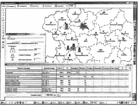
Developed tools allow to formulate inquiries in wide range and allow user to obtain analytical information as text or as map on separate mineral or group of minerals, on fields, on enterprises, on administrative-territorial regions (see Figure I). Information-analytical opportunities of the sub-system cover practically all aspects of presence, changes in balance reserves and use of minerals in territory, object, time and component layers. The sub-system
� �·
has wide means for comparative analysis of territories and objects, for example, on ranking of selected fields on various indexes.
RCMR has allowed to obtain several interesting results on assessment of resource potential of oblast, impact of mining on ecological situation, identification of cause-and-effect relations between mining and ecological state. Firstly, various separate data were combined, Analysis of combustible mineral location together with distribution of ecological network objects has shown the necessity to improve safeguards and environmental protective activity for water bodies and soil protection in case of emergency situations.
·•·l-•lcil- :\i (i) fJr.� llil e 0. Q
'.i"!-
..
.
.
,,,
wrn1:�; m t••-"' '.i : .__...,�._._tlfff'f,:;;:�,, ..--Figure 1. Results of inquiry on natural gas mining in combined way,
2.2 Sub-system "Regional Cadastre of Water Resources"
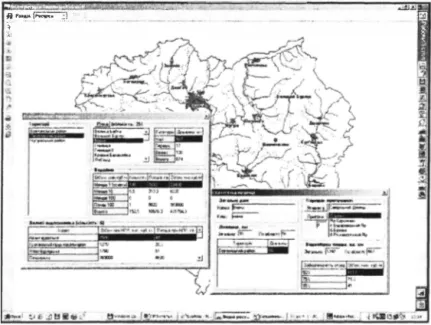
Sub-system "Regional Cadastre of Water Resources" (RCWR) is intended for accounting of water resources and water bodies, analysis of water availability in ob last and its parts, abilities of various types of water use, comparative assessment of ecological state of water bodies, The sub-system was created on similar principles with application of similar tools as previous one.
RCWR allows to give quantitative characteristic of water resources, their distribution on separate administrative units, catchments of separate rivers (see Figures 2, 3). The sub-system allows to give qualitative assessment of water state, its pollution and appropriateness for key types of water sue (drinking water type, recreational type). It allows to make raking and to identify key pollutants that are obstacles for typical water use.
Quantitative characteristics describe both water contamination with various pollutants. They characterize properties of water as a resource from the point of ecological well-being of water
�
--KALMAR, SWEDEN, November 28-30, 2005
eco-system and its appropriateness for specific water use types. Thus, the sub-system presents a complex assessment of water resources quality and their appropriateness from the nature management point of view - and it is very important point.
...
� '�·..!"-·
'
_;_) __-·1!
Figure 2. General assessment of water resources in parts of Oblasl. :nr,i.. j':'��-�!=c,.,._-c_1! �;hJJKr ..i �l
\'1�=--=�--3
(.\,, ;� .•.... :.,.�:-�:. ffll11 j _.,Ol{ll lta:).:) 'al, i � jailJ!tais3 ai:r ... .-� �!\1--3., I/'/ t> oi ii iM,Dt-.C:•1"14-:yll911M6py,l .. llOCfl � , ______ (,!/ J_.._.,... � ,____ r,c,Described sub-systems were created on GIS-technologies (Maplnfo 5.0) basis with application of method for integrated cartography. The shell of the information system was created in C++ language, separate modules are written in MapBasic language. The systems are working in Windows 98/NT/2000/XP Operational Systems. At present local versions of sub-systems are created and used. Due to problems with available Internet connection and lack of regional network of state authorities net-variant of RCNR has not been introduced yet.
3 CREATION OF ECOLOGICAL ATLASES
Information distribution to population is an important aspect of environmental management. A set of researches on creation of ecological atlases was performed in the framework of environmental management and information provision. Atlas is a source of key information on region, resources, economic activity, anthropogenic loading, conditions for population dwelling and environmental protection activity.
Methodology for creation of atlas was developed. The methodology includes structure, methods for summarizing and presentation of information, methods for complex assessment and comparison of bodies, methods for ranking of territories on the level of ecological state, etc.
Ecological atlas of Kharkiv Oblast was created [3] (I and 2 editions and CD-version) and Ecological atlas of Lugansk oblast will be published in the nearest future.
4 CONCLUSIONS
Given results characterize works in the domain of information provision of environmental management that are performed in Ukraine. Wide use of information technologies is a key requirement for improvement of state environmental management and ecological safety in the region.
Environmental protection is international task. Creation of common European information space is a key requirement for ecological safety in Europe.
REFERENCES
[l] Makarovskiy E.L., 2003. Use of complex assessments in ecological-resource and mapping of the region with use of GIS-technologies. InterCarto9: GIS for sustainable development of territories. In: Proceedings of International Conference. Novorossiisk, Sevastopol, 25-29 June, pp. 74-80.
[2] Makarovskiy E.L., 2004. Methods of information provision for nature management in region (exemplified by Kharkiv Oblast). In: Problems of environmental protection and ecological safety, pp. 16-32.
[3] Makarovskiy E.L., Solovyov O.Y., Kovalenko G.D. et al., 2005. Ecological Atlas of Kharkiv Oblast. 2-nd ed. 80 p.