Research
SKI Report 2006:12
Geochemical Investigations of
Groundwater Stability
Adrian Bath
May 2005
SKI Perspective
Background
A reasonable understanding of groundwater flow and the expected evolution of groundwater conditions is an important component of a safety assessment for the final disposal of spent nuclear fuel. This is needed both for the evaluation of engineered barrier performance and the analysis of radionuclide transport. The groundwater flow is coupled with the climate change, so the understanding of this coupling is also relevant in the formulation of scenarios. The main tool to gain sufficient insight regarding these aspects is perhaps groundwater flow simulations. Nonetheless, it is essential that the reasonableness of simulation results is evaluated with all types of supplemental information such as composition of groundwater constituents, stable isotopes and characterisation of secondary minerals. This report focuses on the geoscientific understanding that can be obtained through analysis of geochemical data from site investigations.
Purpose of the project
The purpose of this project is to provide an overview of how geochemical information has contributed to the understanding of deep groundwater systems in the context final disposal of spent nuclear fuel. This is expected to provide a basis for addressing the use of geochemical information from the ongoing site investigations in Sweden (Forsmark and Laxemar).
Results
This report describes the concept of groundwater stability, its application in safety assessment and the associated geochemical indicators. Attention is also given to interpretation methods of geochemical information and the uncertainties that must be considered. The main result is a description of groundwater stability and previous evolution of groundwater conditions at several different sites in Sweden (e.g. Äspö, Stripa mine, Finnsjön, Forsmark), in Finland (e.g. Olkiluoto) and elsewhere (Sellafield, Whiteshell area, Tono mine)
Future work
There will be a need for a detailed review and independent evaluation of the emerging database with geochemical information from the site investigations at Forsmark and Laxemar.
Project Information
SKI Project Manager: Bo Strömberg Project Identification Number: 200509040
Research
SKI Report 2006:12
Geochemical Investigations of
Groundwater Stability
Adrian Bath
Intellisci Ltd.,
Willoughby on the Wolds,
Loughborough LE12 6SZ, UK
May 2005
This report concerns a study which has been conducted for the Swedish Nuclear Power Inspectorate (SKI). The conclusions
Executive Summary
The report describes geochemical parameters and methods that provide information about the hydrodynamic stability of groundwaters in low permeability fractured rocks that are potential hosts for radioactive waste repositories. Hydrodynamic stability is, by implication in the Swedish regulations, a property of a prospective site that needs to be examined in the assessment of its suitability for a repository. It describes the propensity for changes in groundwater flows over long timescales, in terms of flow rates and flow directions. Hydrodynamic changes may also cause changes in water compositions, but the related issue of geochemical stability of a potential repository host rock system is outside the scope of this report.
The main approaches to assessing groundwater stability are numerical modelling, measurement and interpretation of geochemical indicators in groundwater compositions, and analyses and interpretations of secondary minerals and fluid inclusions in these minerals. This report covers the latter two topics, with emphasis on geochemical indicators.
The extent to which palaeohydrogeology and geochemical stability indicators have been used in past safety cases is reviewed. It has been very variable, both in terms of the scenarios considered, the stability indicators considered and the extent to which the information was explicitly or implicitly used in assessing FEPs and scenarios in the safety cases.
Geochemical indicators of hydrodynamic stability provide various categories of information that are of hydrogeological relevance. Information about groundwater mixing, flows and water sources is potentially provided by the total salinity of groundwaters, their contents of specific non-reactive solutes (principally chloride) and possibly of other solutes, the stable isotopic ratio of water, and certain characteristics of secondary minerals and fluid inclusions. Information pertaining directly to groundwater ages and the timing of water and solute movements is provided by isotopic systems including tritium, carbon-14, chlorine-36, stable oxygen and hydrogen isotopes, uranium isotopes and dissolved mobile gases in groundwaters, and also by stable isotopes and uranium isotopes in secondary minerals. Information on timing of water and solute movements is important because it indicates any correlation with the timing of external events that might have perturbed and destabilised the groundwater system in the past, and allows a timescale to be estimated for the persistence of stable conditions. There are many sources of uncertainties in deploying these methods, originating from problems or constraints in sampling, analysis and interpretation.
Data from a number of published site investigation projects and research programmes are reviewed to illustrate the patterns of geochemical data and the relationships between them, and how these are interpreted in terms of hydrodynamic stability. Data from Äspö and Stripa and from exploratory boreholes at Finnsjön and other sites in Sweden are compiled and discussed. Preliminary data from SKB’s ongoing site investigations at Simpevarp/Laxemar and Forsmark are not considered in detail but
their general similarities with Äspö and Finnsjön/SFR respectively are introduced into the discussion of geochemical evidence for groundwater stability in inland and coastal areas. Relevant data from Finnish sites including Olkiluoto, from the Whiteshell URL area in Canada, from Sellafield in the UK, and from the Tono area and URL in Japan are also summarised in appendices and discussed because they add further insights into the interpretation of geochemical indicators for a range of geological environments.
The compiled data provide only limited scope for comparison of groundwater evolution and stability between inland and coastal areas in Sweden, because of the patchiness of representative data especially from early site studies. The external changes that might have perturbed stable groundwater conditions in the past are glaciation (i.e. melt water, mechanical loading/unloading and permafrost) and varying sea water infiltration at coastal sites due to changes in palaeo-Baltic and isostatic conditions. The present distributions of palaeo-Baltic sea water in groundwaters at coastal sites vary, reflecting local palaeohydrogeological conditions. It is likely that inland areas have had longer durations of post-glacial fresh water infiltration than coastal areas, possibly causing greater degrees of dilution and dispersion of pre-existing groundwaters and thus overprinting their hydrochemical and isotopic ‘fingerprints’. Lower post-glacial hydraulic gradients relative to inland sites may account for the occurrence of more relict cold-climate water at coastal sites.
Some general observations are based on rather thin evidence and therefore speculative. Firstly, it seems that glacial melt water penetrated many hundreds of metres and in some places to at least 1,000 m depth. However the low remaining proportions of melt water and of much older saline Shield water suggest that melt water flux did not fully displace pre-existing groundwaters at these depths. Secondly, where there has been post-glacial infiltration of palaeo-Baltic sea water, the density stratification or compartmentalisation effect coupled with low hydraulic gradient has reduced rates of subsequent fresh water circulation after shoreline recession.
There are many uncertainties in interpreting these geochemical indicators in terms of the penetration depths of glacial melt waters and the degree to which they replace pre-existing groundwaters, of other aspects of groundwater stability, and of comparisons between inland and coastal groundwater systems. Uncertainties derive partly from the reliability of groundwater samples as being representative of in situ conditions, and partly from the non-uniqueness of interpretative models. Future investigations using these approaches need to improve sampling, to make conjunctive use of geochemical and isotopic indicators which have varying timescales and sensitivities, and to integrate these indicators with palaeohydrogeological modelling to support the development of reliable groundwater flow and solute transport models for Performance Assessment.
Contents
Executive Summary ...i
List of Tables ...iv
List of Figures ...v
1. Introduction ...1
1.1. Objective and Scope of Review... 1
1.2. Background ... 2
1.3. Groundwater Stability in Safety Cases ... 3
1.4. Content of this Report ... 4
2. Palaeohydrogeology and Stability Indicators in Safety Cases ...5
3. Evolution and Stability of Groundwaters...8
3.1. Hydrodynamic Stability... 8
3.2. Timescales ... 10
3.3. Hydrochemical Evolution and Stability... 11
4. Geochemical Indicators of Hydrodynamic Stability ...13
4.1. Indicators of Groundwater Mixing, Flows and Water Sources ... 13
4.2. Indicators of Groundwater Ages and Timing of Water and Solute Movements...14
4.3. Sources of Uncertainties... 16
4.4. Interpretation Methods for Palaeohydrogeology ... 18
5. Geochemical Data from Swedish Sites ...21
5.1. Äspö Hard Rock Laboratory...22
5.2. Finnsjön and SFR Forsmark ... 28
5.3. Stripa Mine ... 29
5.4. Other Swedish Sites... 33
6. Summary of Stability Indications from Illustrative Data ...34
6.1. Äspö Hard Rock Laboratory...34
6.2. Finnsjön and SFR Forsmark ... 34
6.3. Stripa Mine ... 35
6.4. Other Swedish Sites... 35
6.5. Olkiluoto, Finland ... 36
6.6. Other Finnish Sites ... 36
6.7. Whiteshell URL and Other Canadian Shield Areas... 37
6.8. Sellafield, UK... 37
6.9. Tono Mine and Underground Laboratory, Japan... 38
7. Comparison of Stability Indicators in Groundwaters at Inland and ... Coastal Sites ...39
8. Concluding Summary...42
9. References ...45
Appendix 1. Data for Swedish Crystalline Rock Groundwaters ...57
Appendix 2. Olkiluoto and Other Finnish Sites...61
Appendix 3. Other Fractured Rock Groundwater Systems ...67
A3.1 Whiteshell URL and other Canadian Shield areas... 67
A3.2 Sellafield, UK... 72
List of Tables
Table 1. Summary of scenarios considered in PAs for crystalline rock repository sites and of how palaeohydrogeology was interpreted and used in support of PA.
Table 2. Data for groundwaters and secondary minerals that provide information about hydrochemical mixing, water movements and boundary conditions in the past.
Table 3. Data for groundwaters and secondary minerals that provide information about the timing and rates of water and solute movements and mixing
Table A1. Parameters for groundwater samples from Äspö before and after excavation of the HRL and from Laxemar, selected to include most of the isotopic data. Data from Smellie and Laaksoharju (1992), Rhén et al. (1997), Laaksoharju et al. (1998), Tullborg and Gustafson (1999). Tritium analyses carried out by IFE in 1993-4 may be too high and those in 1997-8 are often too high and unreliable (Nilsson, 1999a,b). Tabulated data may differ from later SKB compilations with respect to which data are considered to be representative; the differences are not substantial except for some 3H data.
Table A2. Parameters for groundwater samples from Äspö before and after excavation of the HRL and from Laxemar, selected to include most of the isotopic data. Data from Smellie and Laaksoharju (1992), Laaksoharju et al. (1998), Tullborg and Gustafson (1999). Tritium analyses carried out by IFE in 1993-4 may be too high and those in 1997-8 are often too high and unreliable (Nilsson, 1999a,b).
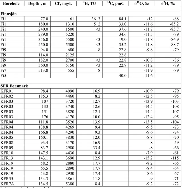
Table A3. Selected parameters for groundwater samples from Finnsjön and SFR Forsmark. Data from Smellie and Laaksoharju (1992), Laaksoharju et al. (1998), Laaksoharju and Gurban (2003), Tullborg and Gustafson (1999), Smellie et al. (1987).
Table A4. Selected parameters for groundwater samples from Fjällveden, Gideå, Svartboberget and Klipperås. Data from Smellie et al. (1985), Laaksoharju et al. (1998), Laurent (1983, 1986).
Table A5. Selected parameters for groundwater samples from Olkiluoto. Data from Lampén and Snellman (1993), Pitkänen et al. (1999, 2004) and SKB (2004).
Table A6. Selected parameters for groundwater samples from other Finnish sites. Data from Smellie et al. (1985), Lahermo and Lampén (1987), Nurmi et al. (1988), Lahermo et al. (1989), Blomqvist et al. (1988), Lampén and Snellman (1993), Ruotsalainen and Snellman (1996) and SKB (2004)
Table A7. Selected parameters for groundwater samples from Whiteshell and other sites in the Canadian Shield. Data from Gascoyne (2004).
Table A8. Selected parameters for groundwater samples from Sellafield, northwest England. Data from Bath et al. (2005).
Table A9. Selected parameters for groundwater samples from Tono area and URL, Gifu, Japan. Data from Iwatsuki and Yoshida (1999), Iwatsuki et al. (2000, 2001).
List of Figures
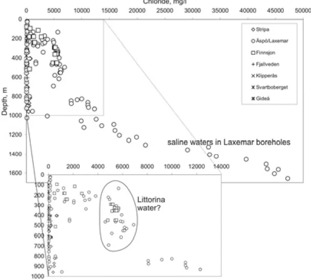
Figure 1. Scheme for interpreting palaeohydrogeology from geochemical and mineralogical indicators (plus indications of transient hydrogeological processes). Figure 2. Salinities, as chloride concentrations, versus depth for groundwaters from
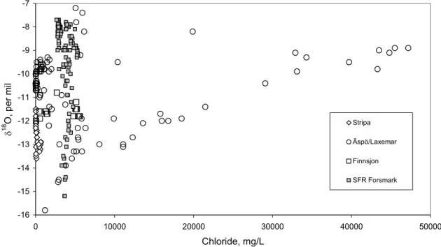
sites in Sweden (upper plot shows only groundwaters at <1000 m depth). Figure 3. 18O/16O versus depth for groundwaters from Swedish sites.
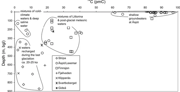
Figure 4. 18O/16O versus chloride concentrations for groundwaters from Swedish sites. Figure 5. Carbon-14 data versus depth for groundwaters from Swedish sites.
Figure 6. Carbon-14 versus chloride concentrations for groundwaters from Swedish sites.
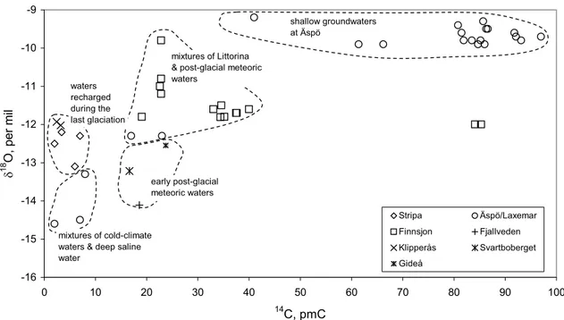
Figure 7. Carbon-14 data versus į18O for groundwaters from Swedish sites.
Figure A1. Carbon-14 versus depth for groundwaters from Finnish sites, plus data from Estonian multi-layered sedimentary rock aquifers (Vaikmäe et al., 2001). Figure A2. Carbon-14 versus chloride concentrations for groundwaters from Finnish
sites, plus data from Estonian multi-layered sedimentary rock aquifers (Vaikmäe et al., 2001).
Figure A3. Carbon-14 versus sample depth for groundwaters from the Whiteshell area, Canada. B&M and URL&W refer to samples from different sets of boreholes. Figure A4. Carbon-14 versus chloride concentrations for groundwaters from the Whiteshell area, Canada. B&M and URL&W refer to samples from different sets of boreholes.
Figure A5. Carbon-14 versus stable oxygen isotope ratio for groundwaters from the Whiteshell area, Canada. B&M and URL&W refer to samples from different sets of boreholes.
Figure A6. NE-SW section through the Sellafield area, showing some of the deep boreholes and contours of groundwater salinity (as mg/L TDS) superimposed onto lines showing the boundaries of the main sedimentary ands basement formations. Figure A7. Chloride concentrations versus sample depth for groundwaters sampled in
deep boreholes at Sellafield, northwest England and also data from investigations of crystalline rocks in Scotland and southwest England (Kay and Bath, 1982 and Edmunds et al., 1987).
Figure A8. NE-SW section through the Sellafield area, showing contours of stable oxygen isotope compositions.
Figure A9. Chloride concentrations and carbon-14 versus sample depth for groundwaters sampled in deep boreholes at Sellafield, northwest England and also data from investigations of crystalline rocks in Scotland and southwest England (Kay and Bath, 1982 and Edmunds et al., 1987).
Figure A10. The two types of crystal morphology for secondary calcite at Sellafield and the systematic variation of calcite morphology as salinity increases with depth (from Milodowski et al., 1997). The ‘c-axis flattened’ morphology (a) corresponds to precipitation from fresh-brackish groundwater and the ‘c-axis elongated’ morphology (b) corresponds to precipitation from saline groundwater. The depth profile of chloride concentration and calcite morphology is for a borehole drillcore from the central-western part of the Sellafield area.
1. Introduction
1.1. Objective and Scope of Review
This report is the result of a contract (Ref. 14.9-010482/01097) from SKI (Project Manager: Dr Bo Strömberg) for a Review of Geochemical Indicators of Groundwater Stability.
The general objective is to inform SKI about the geochemical methods that provide information about the hydrodynamic stability of groundwater systems. Such methods should contribute to sound and adequately comprehensive characterisations of candidate sites for a radioactive waste repository in Sweden.
One of the main ways of assessing scenarios for hydrodynamic stability in a safety assessment is by understanding groundwater movements in the past, i.e. ‘palaeohydrogeology’. Geochemical methods are the key approach to understanding those movements. Geochemical data have to be interpreted to understand their palaeohydrogeological significance, so this report also considers methods for interpretation and the assumptions and uncertainties that are associated with data and interpretations.
In summary, this report describes:
R Geochemical data that are evidence of groundwater travel times and/or solute residence times (‘groundwater ages’) and of past episodes in which groundwater flow and mixing conditions were different from those at present;
R Sources of uncertainties in raw data, and the extent to which those uncertainties might be minimised;
R Interpretation concepts, methods and tools that transform raw geochemical data into knowledge about the groundwater system and specifically about palaeohydrogeology, and the main areas of uncertainties and potential contention; R Background illustrative data from Sweden and elsewhere that illustrate these
methods and exemplify the ‘state of the science’.
Numerical modelling of groundwater movements is the other principal approach to assessing hydrogeological stability and whether groundwater movements might have changed over time between past and present and might change in future scenarios. Numerical modelling is outside the scope of this report, but it is important to remember that it is complementary to the use of geochemical indicators which are qualitative or semi-quantitative tests of the concepts and predictions of numerical models.
Geochemical stability, i.e. the maintenance of the chemical environment in terms of pH, redox and compositions of groundwaters by geochemical water-rock interactions, is also outside the scope of this report but is considered briefly in Section 3.3. Issues of geochemical stability are strongly connected with hydrodynamic stability because, in an isothermal system, they usually concern movements of water masses with
different compositions. For example, such movements are directly implicated in changes of groundwater salinity over time. The issue of redox stability concerns both groundwater movements and the ability of water-rock reactions to buffer the water composition against externally-driven change.
1.2. Background
A safety case for a radioactive waste repository in Sweden must extend for hundreds of thousands of years. Over that length of time, conditions at the land surface will inevitably change due to climatic changes and geomorphologic processes.
One of the attributes of the multi-barrier concept for radioactive waste containment in a geological repository is that the geosphere has long-term stability that allows the engineered barrier system to perform as designed for a very long time. The basic principle is that geosphere stability increases with increasing depth, due to attenuation of the impacts of climate-driven processes at the land surface. Stability ensures a continuity of known physical (including tectonic, rock mechanical and hydrodynamic) and chemical conditions in which the engineered containment provided by the waste canisters and backfill materials can operate as designed in a predictable way for a very long period. Geosphere stability at a particular site and the degree to which a site-specific safety case depends on it need to be tested to build confidence in the models and scenarios on which a safety case is based.
Hydrodynamic stability implies unchanging water flow, in terms of rate and direction. The most likely driving forces that would change water flow rates and/or directions are groundwater pressures at the system boundaries. Chemical stability implies unchanging water compositions which, as discussed in the previous section, are dependent on hydrodynamic stability and the buffering capacity of water-rock interactions. Hydrodynamic and chemical stability are also directly coupled through the effect of chemical composition on the density of groundwater and thus on the pressure (‘head’) that a column of water exerts.
In discussion of how the concept of stability might be assessed for safety assessments, a workshop of the EC-funded PADAMOT palaeohydrogeology project proposed that stability is ‘the capacity of a site to respond to external influences with minimal
impact to the environment of a deep repository’ or ‘the capacity to maintain favourable conditions in the environment of a deep repository’ (Bath et al., 2003,
2005). However it was also suggested that stability is not a simple concept because a low permeability groundwater system is unlikely to be at steady state.
The Swedish regulations for safety in connection with disposal of nuclear waste stipulate that:
‘The repository site and repository depth should be chosen so that the geological formation provides adequately stable and favourable conditions to ensure that the repository barriers perform as intended over an adequate period of time. The conditions intended primarily concern temperature-related, hydrological, mechanical, and chemical factors’ (SKI, 2002).
Groundwater stability is not referred to explicitly in SKB’s compilation of ‘geoscientific suitability indicators and criteria for siting and site evaluation’ (Andersson et al., 2000) but is implicit in the discussion of important parameters to be determined during site investigations, specifically in ‘water chemistry for geoscientific understanding’ (Section 6.5 in Andersson et al., 1998). Variations in groundwater compositions need to be understood because they indicate possible future variations in compositions and properties in both short (e.g. changes due to construction and operation) and long (e.g. ice age) timescales. Evidence of long-term stability of groundwaters is also not in the suitability indicators and criteria for site evaluation (Andersson et al., 2000). Potential impacts of changes will be taken into account in the main and variant scenarios in performance assessment. Nevertheless, it is clear that investigation and interpretation of evidence for groundwater stability should contribute to site evaluation and performance assessment.
SKI’s SITE-94 assessment states that ‘geochemical modelling for prediction of possible future changes at a given site and the consistent description of the variability in geochemical parameters….. must be based on an understanding of how observed geochemical phenomena have developed due to past and present processes’. In SITE-94, a scenario was proposed whereby oxygenated glacial meltwater might be to penetrate to repository depth (SKI, 1996; Glynn and Voss, 1999; Glynn et al., 1999). This was based on a hypothesis that dissolved oxygen might be preserved in infiltrating glacial meltwater. There is palaeohydrogeological evidence in the observation of relict water with cold-climate isotopic composition that glacial meltwater penetrated to more than 1000 m depth beneath the Pleistocene ice sheets. Though the geochemical indicator of a component of glacial water is agreed, the possibility of water remaining oxidising to that depth and thereby causing redox instability is contested by SKB.
SKB carried out modelling of mass transport and geochemical reactions to examine reductive buffering of chemical conditions by rock minerals. Modelling of the oxygenated glacial meltwater scenario assumed that the greatest downwards hydraulic pressure and potential flux of fresh oxygenated melt water will occur while the margin of the ice sheet is passing over the repository location. Modelling results – that there is adequate redox buffering capacity in the rock, specifically in fracture minerals – were supported by the spatial distribution of secondary mineralisation by iron oxides suggesting that dissolved oxygen is attenuated at shallow depths by reaction with ferrous minerals (Guimera et al., 1999; Gascoyne, 1999; Tullborg, 1999; Puigdomenech, 2001).
1.3. Groundwater Stability in Safety Cases
Many performance assessment (PA) models in the past have simulated the long-term behaviour of a repository with a numerical model that is parameterised for present conditions, i.e. assuming steady state groundwater flow with stable hydrodynamic boundary conditions and chemical conditions. In some PA exercises, the impacts on safety of variant scenarios representing future non-steady evolution and potential sources of instability have also been considered.
Three main approaches to assessing long-term groundwater stability have been used in support of PA:
R Numerical modelling of hydrodynamics with parameters and boundary conditions that have been set according to expert judgement of past climate impacts;
R Deductive interpretation and geochemical modelling of present-day groundwater chemical and isotopic compositions to deconvolute the ‘signatures’ of past infiltration conditions and the mixing of water masses that characterises past hydrodynamics;
R Characterisation and geochemical/isotopic analyses of secondary minerals and their fluid inclusions to obtain information about the groundwaters from which they were precipitated.
The main aspects of how these have been used in major PA exercises for crystalline rock sites are discussed further in Section 2.
1.4. Content of this Report
One way to assess the stability of a groundwater system is to investigate evidence for change in the past. ‘Proxy’ indications of past change are investigated, whereby past hydrodynamic or chemical conditions have been recorded in some sort of secondary evidence. Most of such evidence is geochemical (Bath et al., 2000; Bath and Strömberg, 2004; Bath, in press):
R groundwater masses with different compositions whose spatial distribution can be interpreted as evidence of past flow and boundary conditions;
R groundwater compositions that can be interpreted as mixtures of originally-distinct water sources;
R isotopic compositions of groundwaters that can be interpreted to provide absolute or relative ages and thus evidence of the timescales of change and heterogeneity; R assemblages of secondary minerals that indicate geochemical reactions
(‘water-rock reactions) in the past;
R geochemical and isotopic compositions or other mineralogical characteristics of secondary minerals, or of specific growth zones in such minerals, that can be interpreted to give compositions of co-existing groundwaters at the time of formation.
This review describes how these geochemical indicators might be used, gives examples, and evaluates the various sources of uncertainty. Interpretation of measured geochemical parameters is exemplified by reference to data for various groundwater systems and specific formations or sites. Existing data for various Swedish sites, including those at Äspö/Laxemar and Finnsjön which are adjacent to the Simpevarp and Forsmark candidate siting areas respectively, are compiled and evaluated to illustrate potential application of the approach and associated constraints,
uncertainties and alternative models. Some observations are made about the comparison of palaeohydrogeological behaviour of inland and coastal sites, although these are rather speculative because data are sparse In addition, a conceptual background is supplied by data and interpretative models from other studies worldwide in hard rock terrains in Finland, Canada, Britain and Japan. The findings of the review have implications for data requirements and interpretative approaches and models that might be valuable in the safety assessments of Swedish repository sites. The discussion of issues and feasible site investigation methods also has implications for how the concept of ‘stable groundwater conditions’ should be considered in the context of a safety case.
2. Palaeohydrogeology and Stability Indicators in Safety
Cases
In high latitude countries, the scenario generally regarded to have the greatest potential impact on groundwater stability is glaciation. Thus evidence, including geochemical indicators, of the past impacts of glaciation and of periglacial conditions (i.e. continuous or discontinuous permafrost and meltwater runoff) has been investigated to varying extents in the northern and central European programmes (Sweden, Finland, UK, Switzerland) and Canada.
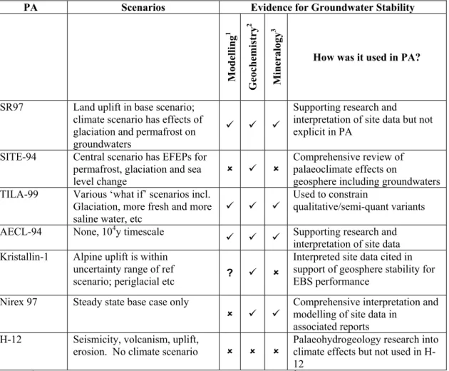
The extents to which the base case or normal evolution scenarios and variant scenarios have been tested or calibrated by palaeohydrogeological interpretation of geochemical indicators of stability are summarised in Table 1.
SKB's safety case exercise SR97 was based on three generic sites (Aberg, Beberg and Ceberg) that were parameterised by data sets from three SKB research sites: Äspö, Finnsjön and Gideå respectively (SKB, 1999). Land uplift is a known trend and was included in the base scenario, whilst climate change and its potential impact on groundwaters were considered variant scenarios. Therefore hydraulic and hydrochemical evolution of the geosphere due to land uplift only is included in the base scenario and potential instability due to other time-dependent changes was comprehensively included in the variant climate scenario. The climate scenario particularly hypothesises on the transient groundwater flows associated with glaciation and permafrost.
Evolution of hydrodynamic and geochemical conditions in the glacial climate scenario of SR97 were based on palaeohydrogeological interpretation of hydrochemical, isotopic and mineral data, though this is not explicitly acknowledged and explained. Conceptual models for future evolution of the geosphere at the three sites were constructed to resemble past evolution as inferred from these interpretations, differing considerably in the expected durations of ice cover and submergence beneath the sea. The magnitude, spatial extent and timing of these changes were studied by modelling that was validated by simulating past changes and comparison with present conditions (Svensson, 1999a, 1999b, Laaksoharju et al, 1998). Modelling of the permafrost scenario was based on the hypothesis that
groundwater flow will be forced to greater depths by the reduction of permeability due to freezing at shallow depths with a consequent reduction in recharge, and also on the suggestion that saline groundwater may be generated by freeze-out as a by-product of pore water freezing. So far, palaeohydrogeology has not produced firm evidence to confirm these hypotheses, although field and laboratory studies at the Lupin Mine (northern Canada) have produced various bits of evidence (Ruskeeniemi et al., 2002, 2004). The overall conclusion in SR97 was that, for the majority of situations considered, even extreme climate change would not substantially affect the safety of a repository at the planned depth.
Table 1. Summary of scenarios considered in PAs for crystalline rock repository sites and of how palaeohydrogeology was interpreted and used in support of PA.
PA Scenarios Evidence for Groundwater Stability
Modelling 1 Geoche mistr y 2 Mineral ogy 3
How was it used in PA?
SR97 Land uplift in base scenario; climate scenario has effects of glaciation and permafrost on groundwaters
9 9 9
Supporting research and interpretation of site data but not explicit in PA
SITE-94 Central scenario has EFEPs for permafrost, glaciation and sea level change
8 9 8
Comprehensive review of palaeoclimate effects on
geosphere including groundwaters TILA-99 Various ‘what if’ scenarios incl.
Glaciation, more fresh and more saline water, etc
9 9 9
Used to constrain
qualitative/semi-quant variants AECL-94 None, 104y timescale
9 9 9 Supporting research and interpretation of site data Kristallin-1 Alpine uplift is within
uncertainty range of ref
scenario; periglacial etc ? 9 8
Interpreted site data cited in support of geosphere stability for EBS performance
Nirex 97 Steady state base case only
8 9 9
Comprehensive interpretation and modelling of site data in
associated reports H-12 Seismicity, volcanism, uplift,
erosion. No climate scenario 8 8 8
Palaeohydrogeology research into climate effects but not used in H-12
Notes:1 Modelling = Palaeohydrogeological numerical modelling; 2Geochemistry = Interpretation of groundwater chemistry and isotope hydrology; 3Mineralogy = Interpretation of secondary minerals and fluid inclusions.
Scenario identification in SKI’s SITE-94 was done in terms of EFEPs (external Features, Events and Processes) (SKI, 1996). The Reference Case involved no changes of the EFEPs over time. A Central Scenario for 120,000 years into the future was developed incorporating changes over time in the EFEPs that concern climate, i.e. permafrost, glaciation and sea-level changes. Assessing the impact of the Central Scenario was aided by quantitative or qualitative information on how past climate events were interpreted as having perturbed the stability of the geosphere, including
data for geochemical indicators such as salinities and isotopic compositions of groundwaters (King-Clayton et al., 1995, 1997). Oxygenated glacial meltwater was hypothesised to have penetrated to more than 1000m depth beneath the Pleistocene ice sheets, as mentioned in the previous section.
Posiva’s safety assessment for four candidate repository sites started out with conceptual descriptions of ‘normal evolution’ of the natural and repository systems (Vieno and Nordman, 1999). The normal evolution safety model in TILA-99 is equivalent to the base scenario in SKB’s SR97. The normal evolution description is divided into five timeframes: up to 100 years, 100 to 104, 104 to 105 years, 105 to 106 years and beyond a million years. These descriptions of normal evolution and the potential effects on the repository system and on geosphere conditions are constrained by palaeohydrogeological interpretations of hydrochemical, isotopic and mineral data. Lines of palaeohydrogeological evidence were (i) the observed distributions of salinity at the four sites (two of which are coastal and two are inland), (ii) the groundwater ages interpreted from stable isotopic and 14C data, and (iii) the distribution of oxidised iron-containing fracture-fill minerals (Pitkänen et al, 1996, 1998a, 1998b, 1999). These indicated that post-glacial land rise and eustatic sea level change have had significant impacts on the evolution of groundwater flow over time at the two coastal sites. The groundwater flow model used in the assessment assumed steady state, but then scenarios were explored by qualitative or semi-quantitative ‘what if’ variants. The hydraulic and hydrochemical conditions and boundaries of these variant models were strongly constrained by palaeohydrogeology for glacial meltwater, fresh-water flow, and saline groundwater scenarios. Since TILA-99, there has been growing interest in the past evolution of the saline-fresh water transition at Olkiluoto in the context of potential upconing of saline groundwater towards an excavated repository.
Canadian regulations at the time of AECL’s safety assessment of the Whiteshell area only required an evaluation of radiological safety up to 10,000 years (Davison et al., 1994). Palaeohydrogeological interpretations were based on ages and compositional mixing of groundwaters and on evidence from secondary minerals that infill fractures. Stable isotope (18O/16O, 2H/1H) and 14C data identified brackish waters in fracture zones at several hundred metres depth corresponding to recharge during the last glaciation, below which there are older saline groundwaters of probable pre-glacial origins (Gascoyne and Chan, 1993; Gascoyne et al, 1999, Laaksoharju et al., 2000; Gascoyne, 2004). Salinity changes and other indications of groundwater mixing indicated that present-day recharge does not penetrate much below 200 m depth and cold-climate waters in the past have not circulated deeper than about 500 m corresponding to a sharp diminution of fracture density (Gascoyne, 2004). Secondary minerals in fractures at various Shield locations were studied by isotopic and geochemical methods from which data were interpreted as indicating episodes of dissolution and precipitation with timing from early hydrothermal conditions to recent groundwater circulation (Bottomley, 1987; Bottomley and Veizer, 1992; Bottomley, 1993; Gascoyne et al., 2003).
The Swiss Kristallin-1 safety assessment considered alternative scenarios for geological and climatic changes versus the reference scenario which assumed that conditions continue as at present and that any changes are negligible (Nagra, 1993).
Potential geological changes associated with continued Alpine uplift were evaluated and were found to have ranges within uncertainty bounds already applied to reference scenario modelling. Changing groundwater fluxes and decreased groundwater travel times were considered by varying parameters in the reference scenario. Geochemical indicators were not used to provide limits to the alternative scenarios. However geochemical indicators were amongst the evidence cited by Thury et al. (1994) in support of hydrodynamic and chemical stability of the geosphere at 400 m depth for reliable operation of the engineered barriers over a long timescale.
The Nirex 97 assessment of post-closure performance of a repository at Sellafield in northwest England was carried out with a groundwater model that assumed steady state conditions, i.e. it used the present-day hydrogeological setting, boundary conditions and measured parameters (Nirex, 1997a). Palaeohydrogeological interpretations of hydrochemical, isotopic and mineralogical data were covered in a supporting report (Nirex, 1997b; Bath et al., 2005). Isotopic data indicated contrasting turnover times in different parts of the groundwater system at Sellafield. Geochemical and mineralogical information from secondary calcite suggested a large degree of long-term stability in the overall distribution of groundwaters although it also indicates varying degrees of relatively minor fluctuations of salinity and redox conditions, the potential effect of which on the stability of near field and EBS (engineered barrier system) environments would need to be considered (Nirex, 1997a, c; Milodowski et al., 1997).
A significant scenario in repository safety assessments in some regions is seismic activity and its potential effect on groundwater movements, especially the transient activation of fast flow pathways from repository depth to surface. The Japanese preliminary safety assessment H-12 focused on the perturbation scenarios of seismicity, volcanism, uplift and erosion (JNC, 1999). These scenarios were assessed qualitatively or semi-quantitatively as variants on a base scenario which assumed uniform steady state groundwater conditions. Palaeohydrogeological studies at two research sites at Tono and Kamaishi have provided geochemical data for the effects of repeated seismic events on groundwater systems in faulted rock areas. In a separate study of the Nojima fault zone, responsible for the 1995 Kobe earthquake, it was found that fracture-fill calcite down to 1800 m depth has formed from infiltration of meteoric and sea waters within the last 60,000 years (Lin et al., 2003).
3. Evolution and Stability of Groundwaters
3.1. Hydrodynamic Stability
Some physical hydrogeological principles and concepts need to be considered when making interpretations about the hydrodynamic stability of groundwater.
Movement of water through a system of low permeability rocks is driven by the pressure gradients due to heads at the boundaries of the system and due to density variations of water within the system. Density variations may be caused by water
compositions and/or by thermal effects, and in an isothermal system are coupled directly to variations of water salinity. Heads at the boundaries of a groundwater system usually are influenced by the topography of the water table above the system. In short timescales, topography of the water table changes with recharge amounts. However in longer timescales, other factors may have affected (or will affect) heads at the boundaries of, and within, a groundwater system. These factors include erosion, uplift and other tectonic forces and climatic impacts such as glacial loading.
The timing of past head changes, the rate of change, and the hydraulic properties will have determined whether a groundwater system is presently in a steady state or
transient state.
‘Steady state’ and ‘stable’ have similar but slightly different meanings in the context of groundwater conditions. Steady state is an important hydrodynamic concept indicating that groundwater movement is occurring at equilibrium with the hydraulic driving forces and constraints. A stable groundwater system (which may or may not be at steady state) is not readily perturbed from its present state i.e. present flux and flow direction are relatively less responsive to potential changes in driving forces within the system and at the system boundaries.
Stability is a rather imprecisely-defined concept concept - it does not mean that a groundwater system is completely inert or that water does not move. Greater groundwater stability is not necessarily correlated with lower permeability, since aquifers can also have inherently stable groundwater conditions. Another way of describing stability is that the system is in a low energy state with respect to driving forces and the potential for change. Responses to perturbations occur slowly and have relatively low magnitudes of change.
Steady state is achieved by a groundwater system when the distribution of heads throughout the system is in equilibrium internally and with heads at the boundaries. During a time step, if there are no head changes at the boundaries then there should be no head changes within the system at steady state. Low permeability groundwater systems are less likely than aquifers to be at steady state hydrodynamically because they respond to pressure changes at boundaries more slowly. A groundwater system in low permeability rocks is in a transient state if heads within the system continue to change when the heads at the boundaries remain constant. The effect is like a ‘delayed response’. The time for which the transient state might persist depends on the pressure diffusivity and the distance scale. However if the system has responded to the external changes by mass transport of water masses with different densities, then the persistence of the transient state may be controlled by the diffusivity for mass transfer. Pressure, or hydraulic, diffusivity for a low permeability crystalline rock is around 10-5 to 10-4 m2/s, whereas the large scale mass diffusivity is likely to be around 10-10 to 10-11 m2/s.
Consideration of the stability of a low permeability groundwater system needs to understand how the potential for change varies spatially and temporally. Spatial variation is significant primarily because, in general, groundwater stability is expected to increase with depth, i.e. with increasing distance from climate changes and other energy perturbations at the surface, especially in a low permeability system.
Temporal variation is considered in terms of the timeframes (short term or long term, i.e. operational versus post-closure safety timescales) for a perturbation of driving forces and for the consequent response of the groundwater system. In a low permeability groundwater system, transient conditions are likely to prevail because mass movement of groundwater in response to pressure changes at the boundaries is much slower than it is in a system with higher permeability. Putting past groundwater changes into an absolute or relative timeframe is one of the aims of geochemical (specifically isotopic) investigations in palaeohydrogeology.
3.2. Timescales
It is clearly important to establish the timescale over which the evolution of a groundwater system is being interpreted and its stability or otherwise is considered to be significant. For this discussion, it is proposed that three divisions of timescale in the past should be considered:
0 to 1000 years 103 to 105 years >105 years
These timescale divisions are useful for present purposes because they are compatible with the age ranges and mixing timescales for groundwaters that can be quantified with presently-available isotopic and geochemical methods. For example, the 0-1000 years timescale includes groundwaters that were recharged relatively recently and therefore are likely to have a detectable content of thermonuclear tritium (3H) which indicates ‘modern’ water, i.e. less than 50 years old. 103-105 years corresponds roughly to the timescale that can be resolved with carbon-14 (14C) dating which is up to about 35,000 years for groundwater ages. The 103-105 years timescale includes the Holocene post-glacial and the late-Pleistocene glacial periods, so groundwaters with those ages may or may not have depleted stable isotope ratios (18O/16O and 2H/1H) that are characteristic of cold-climate recharge. Groundwaters with ages >105 years can be categorised as ‘very old’ and can be characterised by the content of the long-lived cosmogenic isotope chlorine-36 (36Cl) relative to the bulk of dissolved chloride. They are also sensible divisions in the context of a repository safety assessment (NEA, 2002; Dverstorp and Strömberg, 2005). The first 103 years into the future is critical in terms of repository performance and the high radiotoxicity of the inventory. It also corresponds to the timescale of ‘human experience’ within which biosphere fluctuations have been minor relative to the glacial and interglacial fluctuations of longer periods. The 105 year timescale corresponds roughly to that of a glaciation cycle, for which repository performance should be robust. As already discussed, geosphere stability is an important contributor to that robustness. The most recent of several ice age episodes in northern Europe that must have had some influence on groundwater evolution occurred 103 to 5 x 10⁴ years ago.. In addition to the tectonic (i.e. crustal depression) and hydrological (i.e. melt water) effects of the ice sheet at the peak of glaciation, there was also a considerably longer period when permafrost might have affected groundwater evolution.
>105 years is the upper end of the timescale for which safety analysis has any meaning and is also the timescale in which the radiotoxicity of a spent fuel inventory will have diminished to having the same hazard as the uranium ore from which the nuclear fuel was originally derived.
SKB evaluates the roles and performance of engineered and geosphere barriers in ‘nested’ timescales of 0 to 1000 years (the thermal phase), 0 to ca.104 years (the isolation phase) and to >104 years (the geologic phase) (A. Hedin in NEA, 2002).
3.3. Hydrochemical Evolution and Stability
The major aspects of hydrochemical evolution that are of interest with respect to a repository safety case are:
o salinity and density,
o redox (especially dissolved oxygen content), o pH conditions.
Other geochemical properties of a groundwater system that are of interest in understanding its evolution and stability are:
o concentrations of specific solutes,
o equilibria between groundwaters and minerals, and precipitation/dissolution, o diffusive exchange with matrix in a dual porosity or fractured rock medium, o sorption and exchange of solutes by mineral/colloidal/microbial material.
SKB focuses its hydrochemical strategy on a number of ‘suitability indicators’, primarily salinity, redox as a proxy for dissolved oxygen, and pH, and secondarily a number of other parameters. The suitability indicators represent the main variants in the chemical environment of the repository that might influence its performance, particularly in terms of corrosion of the spent fuel canisters, and swelling and mechanical integrity of the bentonite buffer and backfill mixture. The long-term stability of these parameters is therefore an essential consideration in safety assessment.
Salinity (total mineralisation or TDS) is controlled by movement and mixing of groundwaters from different sources. Salinity for most groundwaters that have dominantly Na-Cl compositions is linearly related to chloride concentrations. Interpreting variations in chloride or salinity and using these variations to calibrate models are important aims in a site investigation. Moreover, because density is linearly related to salinity, interpreting salinity variations and sources is a key aspect of interpreting changes in forces that drive movement and thus physical stability of groundwaters.
Redox conditions in groundwaters surrounding a repository should be stable regardless of temporal fluctuations of redox at the outer boundaries of the host groundwater system. In the KBS-3 disposal concept, the use of copper canisters has a more specific requirement that dissolved oxygen should be excluded. Recharging
groundwaters contain dissolved oxygen and therefore are oxidising. Under normal conditions of groundwater evolution, dissolved oxygen and other solutes that support oxidising conditions are consumed by geochemical reactions that ‘buffer’ deeper groundwaters to be reducing. Geochemical equilibria and ‘buffering’ mineral phases need to be sufficiently well-understood and characterised for a particular site that this aspect of hydrochemical evolution can be predicted with confidence (Guimerá et al., 1999).
Geochemical equilibria that control groundwater pH within the acceptable range need to be similarly understood. Evolution of pH from the point of recharge through flow to depth in a groundwater system is most likely to be controlled by combinations of partial pressure of CO2 (pCO2) at recharge and reactions with carbonate and aluminosilicate minerals.
Concentrations of specific solutes in groundwaters, and how they evolve over time, may be directly relevant to specific aspects of repository safety or they may be useful tracers or indicators of geochemical change and stability. Various trace elements are included, for example redox-sensitive solutes such as Fe, Mn, SO4 and U. However they can only be useful as indicators of evolution over time if an ‘archive’ of past concentrations can be analysed; such an archive may be provided by secondary minerals which have grown over the timescale of interest (Degnan and Bath, 2005). Evolution over time of the state of geochemical equilibria between minerals and groundwater determines the direction of water-rock reactions, i.e. the propensity for precipitation or dissolution of minerals. Such equilibria are essentially a measure of the chemical stability of a groundwater. The inventory of minerals that is available in the secondary mineral assemblage within fractures of a crystalline rock controls the extent of buffering of water compositions to externally-imposed changes (e.g. in redox). Minerals in the rock matrix may also provide some buffering capacity, and they also may provide sorption capacity. However the role of matrix minerals and matrix pore water in influencing the hydrochemical evolution and stability of groundwater in a fracture network is dependent on the relative timescales for diffusion into and out of matrix and for externally-driven changes to groundwater in fractures (e.g. mixing). Potentially, fracture-matrix interaction could be a major effect on hydrochemical evolution and stability.
In summary, the stability of acceptable values for the primary hydrogeochemical suitability indicators (salinity, redox, pH) and secondary indicators (dissolved organic carbon DOC, colloids, NH4+, Ca2+ & Mg2+, Rn) is determined by both the stability of groundwater flow and mixing and the continuation of water-rock buffering reactions, as described above for the primary indicators.
Of the secondary indicators, increases of NH4+ and DOC would depend on inputs from the surface boundary, i.e. climate/soil/surface water conditions that stimulated additional production and infiltration of these from organic sources. However the concentrations of these in groundwaters at depth would remain controlled by rock reactions, primarily redox. Colloid abundances are dependent on both water-rock reactions and salinity, and also possibly on external inputs as with DOC. Ca2+ and Mg2+ are controlled by water-rock reaction and also depend on external inputs,
primarily increase due to a Ca-rich brine (thus not itself a challenge to the requirement of >4 mg/L) or decrease due to rapid injection to depth of very dilute groundwater (e.g. unmixed, unreacted glacial meltwater).
Rn is controlled by local release from mineral hosts of U and Ra. The level of Rn is a safety issue during a construction and operational phase of a repository. Thus the stability concern is how Rn will change from the undisturbed condition, as measured during site investigation, to the highly perturbed groundwater drainage and ‘degassing’ regime caused by the hydraulic gradient towards an excavation.
4. Geochemical Indicators of Hydrodynamic Stability
Geochemical indicators provide two basic types of information about hydrodynamic stability: (i) the physical processes of chemical mixing that are linked with water movements, and (ii) the timing and rates of water movements (NEA, 1992, 1999). Investigations of groundwater stability should ideally analyse for geochemical indicators in both groundwaters and secondary minerals:
x Chemical and isotopic compositions of groundwaters which are mixtures of waters from distinct sources whose spatial distributions indicate flow and boundary conditions in the past, and whose absolute or relative ages indicate the timescales of water movement and mixing;
x Mineralogy and compositions of secondary minerals, and the characteristics of fluid inclusions contained in them, which indicate the geochemical conditions and water-rock reactions that prevailed at the times of formation.
The hydrochemical and mineralogical parameters that are required for palaeohydrogeological interpretations about the physical process of chemical mixing that is linked with water movements, and the timing and rates of water movements, are discussed in Sections 4.1 and 4.2 respectively.
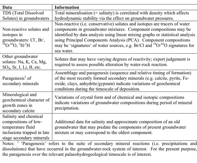
4.1. Indicators of Groundwater Mixing, Flows and Water Sources Data from groundwaters and secondary minerals that are most likely to provide information about mixing and past movements of water masses from different sources are summarised in Table 2.
Palaeohydrogeological information about groundwater mixing, flows and water sources in the past has to be compared with the present-day hydrodynamic and hydrochemical state of the system to make inferences about groundwater stability. The following questions can be addressed:
x Do hydrochemical and isotopic analyses indicate that past patterns of mixing of groundwater components were different from that at the present day, e.g. different sources or degrees of mixing?
x Do secondary mineral assemblages and mineral characteristics (e.g. crystal morphologies) and compositions indicate that past groundwater compositions were different from present compositions, and can the ages of the minerals be estimated? x Are compositions of fluid inclusions, matrix waters or compartmentalised
‘pockets’ of groundwater inconsistent with present-day groundwater compositions?
Table 2. Data for groundwaters and secondary minerals that provide information about hydrochemical mixing, water movements and boundary conditions in the past.
Data Information TDS (Total Dissolved
Solutes) in groundwaters
Total mineralisation (= salinity) is correlated with density which affects hydrodynamic stability via the effect on groundwater pressures. Non-reactive solutes and
isotopes in
groundwaters: Cl-, Br-,
18
O/16O,2H/1H
Non-reactive (i.e. conservative) solutes and isotopes are tracers of water components in groundwater mixtures. Component compositions may be identified by data analysis using linear mixing graphs or statistical analysis using Principal Components Analysis (PCA). Component compositions may be ‘signatures’ of water sources, e.g. Br/Cl and 18O/16O signatures for sea water.
Other groundwater solutes: Na, K, Ca, Mg, SO4, Sr, I, Li, B, etc.
Solutes that may have varying degrees of reactivity; expert judgement is required to assess possible alteration by water-rock reaction.
Paragenesis1 of secondary minerals
Assemblage and paragenesis (sequence and relative timing of formation) of the most recently formed secondary minerals (e.g. calcite, pyrite, Fe-oxide, clays, anhydrite/gypsum) indicate variations of geochemical conditions during the timescale of deposition.
Mineralogical and geochemical character of growth zones in
secondary calcite
Variations of crystal form and of chemical and isotopic compositions indicate variations of groundwater compositions during period of mineral precipitation.
Salinity and chemical compositions of low-temperature fluid inclusions trapped in late stage secondary minerals
Additional data for salinity and approximate composition of an old groundwater that may predate the components of present groundwater mixture or may correspond to the oldest component.
Notes: 1 ‘Paragenesis’ refers to the suite of secondary mineral reactions (i.e. precipitations and dissolutions) that have occurred in the groundwater-rock system of interest. For the present purpose, the paragenesis over the relevant palaeohydrogeological timescale is of interest.
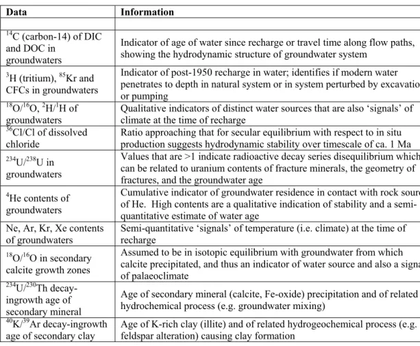
4.2. Indicators of Groundwater Ages and Timing of Water and Solute Movements
Data from groundwaters and secondary minerals that may provide information about the ages of groundwaters and about the timing of water and solute movements are summarised in Table 3.
Information from these data about the distribution of water ages through a groundwater system can address the following questions relating to the timescale over which palaeohydrogeological evidence of groundwater stability is available and how the chronology of processes in a groundwater system can be interpreted:
x What overall timescale is represented by the groundwater system, i.e. is a maximum ‘turnover time’ indicated, and what is the age of the oldest water component in mixed groundwaters?
x Does the pattern and continuity of groundwater ages suggest steady-state conditions over a period of time up to the present, or are there peaks or gaps that indicate deviations from present-day or steady-state conditions?
x Are groundwater ages consistent with the hydrodynamic model using present-day boundary conditions or are different boundary conditions required to explain the observed pattern of water ages?
x Does the pattern of groundwater ages and inferred boundary conditions correspond with known episodicity of palaeoclimate?
Table 3. Data for groundwaters and secondary minerals that provide information about the timing and rates of water and solute movements and mixing (Clark and Fritz, 1997, provides further background).
Data Information
14
C (carbon-14) of DIC and DOC in
groundwaters
Indicator of age of water since recharge or travel time along flow paths, showing the hydrodynamic structure of groundwater system
3
H (tritium), 85Kr and CFCs in groundwaters
Indicator of post-1950 recharge in water; identifies if modern water penetrates to depth in natural system or in system perturbed by excavation or pumping
18
O/16O,2H/1H of groundwaters
Qualitative indicators of distinct water sources that are also ‘signals’ of climate at the time of recharge
36
Cl/Cl of dissolved chloride
Ratio approaching that for secular equilibrium with respect to in situ production suggests hydrodynamic stability over timescale of ca. 1 Ma
234
U/238U in groundwaters
Values that are >1 indicate radioactive decay series disequilibrium which can be related to uranium contents of fracture minerals, the geometry of fractures, and the groundwater age
4
He contents of groundwaters
Cumulative indicator of groundwater residence in contact with rock source of He. High contents are a qualitative indication of stability and a semi-quantitative estimate of water age
Ne, Ar, Kr, Xe contents of groundwaters
Semi-quantitative ‘signals’ of temperature (i.e. climate) at the time of recharge
18
O/16O in secondary calcite growth zones
Assumed to be in isotopic equilibrium with groundwater from which calcite precipitated, and thus an indicator of water source and also a signal of palaeoclimate
234
U/230Th decay-ingrowth age of secondary mineral
Age of secondary mineral (calcite, Fe-oxide) precipitation and of related hydrochemical process (e.g. groundwater mixing)
40
K/39Ar decay-ingrowth age of secondary clay
Age of K-rich clay (illite) and of related hydrogeochemical process (e.g. feldspar alteration) causing clay formation
A stable low-permeability system will tend to contain old groundwaters, though the tendency to mix by diffusion and advective dispersion means that old groundwater masses may no longer be distinguishable in terms of discrete sources and ages. In a low-permeability system, there is usually a pattern of vertical stratification of groundwater masses with the possibility of steep increases in water age with increasing depth. This vertical segregation of water masses may be controlled by changes in permeability and by the decay with increasing depth of topographic head
as the driving force for lateral water movement. The pattern of vertical stratification is reinforced by density stratification at sites where groundwaters have varying salinity.
4.3. Sources of Uncertainties
In using and interpreting the indicators of hydrodynamic stability to support a safety assessment of a potential repository site, uncertainties in data and interpretations need to be considered. In general, the uncertainties in geochemical and mineralogical analyses are likely to be less significant than the interpretative uncertainties. Regarding the types of data that are listed in Tables 2 and 3, the potential sources of data uncertainty and their magnitude and significance are:
x In hydrochemical and isotopic data for interpretation of movements and mixing of water and changing boundary conditions:
o Uncertainties in analyses of concentrations of the major hydrochemical solutes and of Total Dissolved Solids (TDS) are likely to be of low significance except in dilute groundwaters (see below);
o Uncertainties in concentrations of non-reactive (‘conservative’) solutes in dilute groundwaters may be significant for interpretations of mixing in cases where reliable detection and quantification of small proportions of exotic components (e.g. sea water, deep saline groundwater) are required;
o Uncertainties in analyses of conservative natural tracers, e.g. 18
O/16O, 2H/1H, Br-, may be significant for interpretations of mixing; analytical uncertainty in stable isotope ratios especially may typically be 10% or more of the contrast between components and also compositions of end-members may have relatively large uncertainties, so resolution of mixing proportions may have substantial uncertainty;
o Degrees of alteration of some major solutes (i.e. Na, Mg, K, Ca, SO4, HCO3) and many minor solutes (e.g. Fe, Mn, I) due to water-rock interactions may have large variations, so that using these parameters in mixing analyses introduces large uncertainties.
x In mineralogical data for assemblages, properties and compositions of secondary minerals, and also fluid inclusion analyses:
o Identifications of parageneses is a matter of expert judgement and should be based on a representative number of microscopic petrographic analyses; a large number of measurements are needed to interpolate observations through a rock volume typical of a repository site and to identify spatial patterns with reasonable reliability;
o Uncertainties in the descriptions of secondary mineral assemblages and parageneses become most significant if trace accessory minerals are missed or wrongly identified;
o Relative ages of secondary minerals are open to quite large uncertainties without absolute mineral ages by U-Th dating; late-stage mineral parageneses have relative ages attributed according to their growth characteristics;
o Mineralogical data should be obtained for minerals that are volumetrically significant and representative for the whole rock mass and groundwater system, or part of it, being investigated;
o Analyses and interpretation of chemical and isotopic compositions of growth zones in secondary minerals (e.g. calcite) depend on the assumption that there has not been recrystallisation or other alteration of the compositional zoning subsequent to precipitation; there is considerable evidence, for example the distinct boundaries between growth zones, that support this assumption; bulk re-equilibration is discounted by the existence of compositionally-distinct growth zones;
o Another source of uncertainty in analyses of secondary minerals is the variability of compositions within and between growth zones;
o Calibrations of mineral compositions, especially for trace elements in analyses by electron microprobe (EPMA) or energy-dispersive X-ray analysis in scanning electron microscopy (SEM) may be difficult for variable matrices and microscopic minerals, introducing uncertainties of 20% upwards;
o Calibrations and precision of stable isotopic analyses, e.g. 18
O/16O and 13C/12C in calcite, in secondary minerals may introduce further substantial data uncertainties to the interpretation of co-existing groundwater compositions and mixtures, because of ‘small sample’ effects and also due to use of novel techniques such as laser ablation analyses of individual mineral growth zones; o Uncertainties in the age and therefore in the relationship of inclusion fluids to
groundwaters presently in the system are substantial unless the enclosing secondary mineral can be dated reliably;
o Data from microthermometry for temperatures of formation and for salinities of fluid inclusions are likely to have large uncertainties and apparent variability that are significant when comparing with present groundwater compositions, especially for dilute inclusion fluids because the lower limit of quantification is brackish/saline; there is a lower limit on temperature estimation because low temperature inclusions, i.e. those of direct interest for palaeohydrogeology, tend to be monophase and not amenable to the homogenisation temperature method; o Data from fluid inclusions are obtained either by microscopic analyses of
individual inclusions, in which case a statistically-significant number of replicate analyses are required to reduce uncertainty, or by macroanalysis of crush-leach solutions in which case the compositional data are averages and do not identify the ranges of compositions in a specific generation of inclusions. x In isotopic data for interpreting groundwater and secondary mineral ages and the
timing of water and solute movements:
o Contamination of water samples taken for tritium (3
H) and carbon-14 (14C) analyses usually introduces errors that make water ages too young;
o Analytical uncertainties at low 3
H and 14C abundances, near to detection limits, are relatively high and become very significant because whether or not there is evidence of small proportions of a young 3H-bearing component or detectable 14
C may have great significance to interpretations about the timescales of stability;
o Uncertainties in anthropogenic 3
H inputs to groundwater systems during the last 50 years and also the ambiguity between 3H levels in present-day inputs and
decay-adjusted values for less recent, plus the added effect of dispersion and mixing, make quantitative interpretation of sparse 3H data unreliable and effectively mean that 3H is a qualitative indicator of the presence of a smaller or greater component of water which has recharged within 50 years;
o Uncertainties in initial 14
C activities at time of recharge are significant for 14C ages of groundwaters and may introduce uncertainty of 5000 years, i.e. around one half life, which is especially significant for reliable dating of groundwaters with ages <10,000 years, i.e. Holocene recharge;
o Analytical uncertainties in 36
Cl data may be significant for interpretation, especially in cases where residence times of very old (>106 years) groundwaters are being investigated by comparison with 36Cl/Cl ratios estimated for secular equilibrium from data for in situ production of 36Cl.
4.4. Interpretation Methods for Palaeohydrogeology
Some of the specific interpretation methods for palaeohydrogeological data and stability indicators have already been mentioned in the previous section in the context of uncertainties. This section summarises the main approaches to interpreting hydrochemical, isotopic and mineralogical data to get information about palaeohydrogeology, relationship to palaeoclimate episodes, and groundwater stability. The types of models are:
x Geochemical equilibrium models of water-rock reaction; x Hydrochemical mixing models;
x Groundwater flow and mass transport-reaction models to simulate effects of changing hydrogeological and/or geochemical initial and boundary conditions; x Isotopic fractionation factors;
x Calculation of groundwater ages from isotopic data.
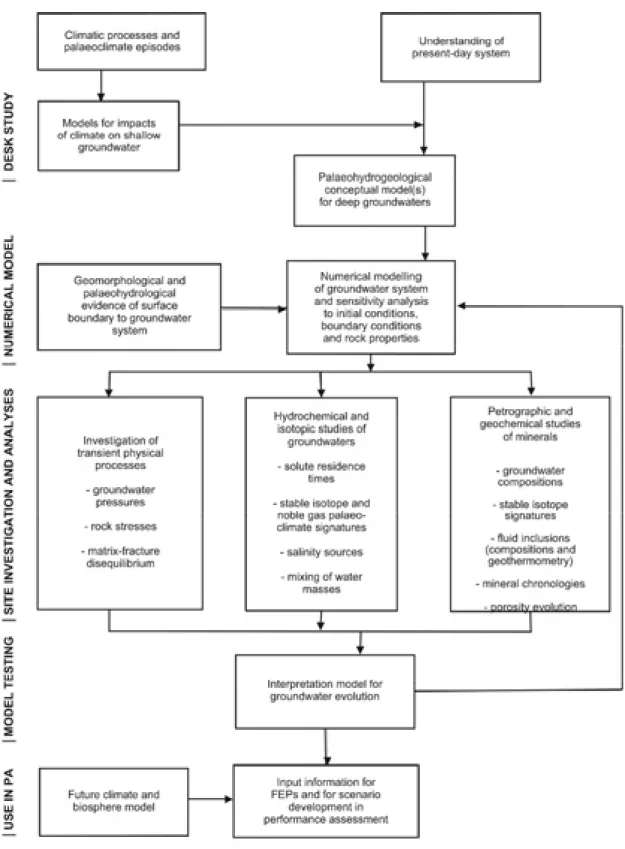
Interpretations of geochemical indicators contribute to a geoscientific approach to palaeohydrogeology which includes consideration of indications of physical and mechanical effects on groundwater stability as well as the geochemical indicators (Figure 1). The approach involves models for hydrological impacts of climate changes, which are assumed to be the primary causes of potential instability, and models for the response of the groundwater system. Conceptual models are constructed to represent potential variations in surface boundary and initial conditions correlated with palaeoclimate changes over time. Numerical transport modelling is carried out to simulate distributions of non-reactive solutes and stable isotopes, and then these simulations are compared with observed distributions of these geochemical indicators in the present groundwater system.
Figure 1. Scheme for interpreting palaeohydrogeology from geochemical and mineralogical indicators, plus indications of transient hydrogeological processes (from Bath et al., 2000).
Mixing models, which range from simple crossplots resolving 2-component mixing of conservative solute tracers (e.g. Cl-, Br-) and stable isotope ratios (į18O, į2H), to multivariate analysis (e.g. with SKB’s M3 Principal Components Analysis tool)