Analysis of Future Discharge in Nakdong River Basin According to
Ef-fect on Climate Change
Hyun Suk Shin1, Mi Eun Kim2, Ji Ye Im, and Tae Seok Shon3
Department of Civil and Environmental Engineering, Pusan National University, Pusan 609-735, South Ko-rea
Abstract. Climate change has affected water resources and environment all over the world and its
impacts assessment and adaptation are very important issues that are significant in terms of science and policies. In view of water resources, estimation of discharge is essential to make basic data in watershed management and water environment like flood and drought. The change of discharge has affected both eco-system and human system. So that, using technical methods are necessary to develop nature restoration and disaster reduction. Therefore, this study applied to GCMs (General Circulation Models) using A1B scenario which reflects climate characteristics of Korea well and analyze out the future climate change discharge. The main result of these studies is compared and analyzed at Nakdong River basin about discharge by A1B scenario. The study period (2011~2100) was divided into three periods (F1:2011~2040, F2:2041~2070, F3:2071~2100) and compared with observed data for 1980~2009. This study presents technical methodology for assessing influence on water environment resources. Furthermore, the results of this study expect to be quantitative and reliable data in studying climate change throughout the application to other rivers. If water envi-ronment impact assessment and analysis of the future water balance including a forecast of water supply and demand take place based on the results of this study, the results will be sufficiently val-uable both as researches on national measures to climate change and policy materials.
1. Introduction
Many countries intend to develop assessment techniques for climate change effect that will both reduce and prevent the impacts of such as flood and drought disasters on public security. Thus, increasing the future discharge further activates the hydrologic cycle along with the increase in temperature, which causes appearances of exceptional phenomena, the extreme events, which were not observed in the past. So that, using technical methods are necessary to develop nature restoration and disaster reduction. Therefore, this study ap-plied to GCMs (General Circulation Models) using A1B scenario which reflects climate characteristics of Korea well and analyzed out the future climate change discharge. Based
1 Civil Engineering Division
Civil and Environmental Engineering Department Pusan National University, Busan
Tel: (82)51-510-2348 e-mail: hsshin@pusan.ac.kr
2 Civil and Environmental Engineering Department Pusan National University, Busan
Tel: (82)51-510-3288 e-mail: way8210@naver.com
3 Corresponding author: Brain Korea 21 Division
Ubiquitous-Applied Construction of Port Logistics Infrastructures Pusan National University, Busan
Tel: (82)51-510-3288 e-mail: tsshon1@hanmail.net
on selection of the most appropriate GCMs in Korea, which is the most fundamental and basic stage for climate change analysis, and application of downscaling techniques for pre-cise materialization of meteorological patterns of Korea in terms of space and time, the current climate change scenarios and those forecasting the next 90 years were produced and applied. The SWAT model of hydrologic models was used for analyzing discharge at Nakdong River. The main result of this study is compared and analyzed at Nakdong River basin about discharge by A1B scenario. The study period (2011~2100) was divided into three periods (F1:2011~2040, F2:2041~2070, F3:2071~2100) and compared with observed data for 1980~2009. Climate change effect on frequency based precipitation was assessed quantitatively by using daily precipitation and precipitation frequency map. As a result of this study expect to be quantitative and reliable data in studying climate change throughout the application to other rivers and forecast the future discharge by the impact of climate change.
2. Study area and Method
2.1. Study area
The Korea peninsula extends southward from the northeastern part of Asia between 33-45°N Latitude and 124-131°E Longitude. About 70% of the land is covered with moun-tains, particularly in the east and north. The region of Korea has humid continental climate and a humid subtropical climate mostly. Average temperatures range from about -10°C in winter to about 30°C in summer. Winter temperatures are higher along the southern coast and considerably lower in the mountainous interior. Rainfall is affected by the East Asian moon-soon, and rainfall activity experiences diurnal variation with a night-time preference, especially toward heavier precipitation categories. Korea is divided into five major river basins: Han River basin (26,081 km2), Nakdong River basin (23,817 km2), Geum River ba-sin (9,810 km2), Seomjin River basin (4,897 km2), and Youngsan River basin (3,371 km2). The Nakdong River basin, with about 23.8% of the area, is the second largest among the basins. In this study, two rainfall data sets are considered: (1) rainfall for the period
1980~2009 obtained through downscaling of coarse-scale climate outputs produced by the climate model with the IPCC SRES (Intergovernmental Panel on Climate Change Special Report on Emission Scenarios) 20th Century Climate in GCMs. (2) the future rainfall (2011–2100) is obtained through downscaling of climate outputs projected by the A1B emission scenario of CSMK, CNCM, CT63, MPEH.
2.2. Methods
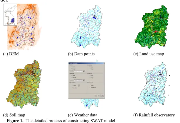
Based on selection of the most appropriate GCMs in Korea, which is the most funda-mental and basic stage for climate change analysis, and application of downscaling tech-niques for precise materialization of meteorological patterns of Korea in terms of space and time, the current climate change scenarios and those forecasting the next 90 years were produced and applied. The long-term watershed model that can perform analysis of hydro-logic cycle is necessary to evaluate potential of water environment and runoff changes in river by climate change. Therefore, SWAT model was chosen in this study to simulate long-term climate change forecasting based on watershed. SWAT model has developed in order to forecast phenomenon of hydrology, sediment, and nutrients in complicated water-shed in large scale according to land-use. Thus, it calculates emission of pollutant and
hy-drologic quantity by HRU (Hyhy-drologic Response Unit) consists of soil map and land use. Moreover, the watersheds are divided into sub-watersheds using data of stream network and digital terrain elevation data linked to Arc-view GIS software. To build SWAT model based on GIS, the DEM is created by 1:50,000 topographic maps from National Geograph-ic Information Institute. So that, soil map applied to land use map using 1:50,000 recon-naissance soil maps by Korea Rural Development Administration and classification map of land coverage by Korea Ministry of Environment. This study performed calibration and verification of daily rainfall at points using general Kriging technique through collecting data in selected rainfall observatory. On top of that, computation of average rainfall at wa-tershed was implemented in order. The model adapted daily rainfall of average in water-shed from selected 56 rainfall observatory to simulate daily volume of runoff. Thus,
SWAT model is required meteorological data such as solar radiation, air temperature, wind speed, and relative humidity to compute evaporation. In addition, this model used modi-fied monitoring data and collected data of daily inflow and outflow for watershed simula-tion in upper reach of the dam. The figure 1 shows detailed process of constructing SWAT model.
(a) DEM (b) Dam points (c) Land use map
(d) Soil map (e) Weather data (f) Rainfall observatory
Figure 1. The detailed process of constructing SWAT model
3. Results
The main result of this study is compared and analyzed in two points about the future discharge by A1B scenarios that are divided into 3 periods. Annual and the seasons averages of discharge by GCMs in the 2 points (Andong Dam, and Jindong which are located in the upper, and downstream points of Nakdong river) to compare between the present and the future during 90 years (2011~2100) using GCMs. The annual discharge of CT63 model at Andong Dam and CNCM model at Jindong was the highest value both in F3 (2071~2100) period. By the seasons, spring in the upper site presented the highest discharge compare to summer, fall, and winter and the future discharge in the downstream showed lots of increasing all seasons. In particular, MPEH model was the highest all over
the seasons at Andong Dam then CNCM in spring and winter, CT63 in fall and MPEH in summer was the highest values at Jindong. Overall, the future discharges which were forecasting by GCMs were higher than present.
Table 1. Discharge by impacts on climate change at Nakdong river sites based on GCMs
Year GCMs Andong Dam (Q: cms) Jindong (Q: cms)
Annual Spring Summer Fall Winter Annual Spring Summer Fall Winter
Present 30.57 16 55 36 6 429.62 218 753 567 148 2011-2100 CSMK 32.60 19 56 44 12 501.63 249 931 644 175 CT63 36.08 21 59 51 13 518.35 264 926 696 179 CNCM 33.75 19 57 45 14 515.43 261 931 661 201 MPEH 36.47 22 54 56 13 525.80 261 931 661 201 2011-2040 CSMK 33.81 18 58 44 12 514.60 229 885 624 166 CT63 34.93 17 59 41 11 502.23 230 955 610 166 CNCM 30.10 19 49 38 19 463.56 233 757 537 168 MPEH 33.59 20 69 56 13 483.88 249 1067 772 190 2041-2070 CSMK 32.19 19 62 52 13 492.32 236 961 705 174 CT63 36.49 20 55 51 14 521.16 259 883 694 190 CNCM 34.40 18 53 53 14 513.09 232 830 744 186 MPEH 38.14 22 57 46 12 560.02 292 897 670 184 2071-2100 CSMK 31.81 20 52 39 11 497.96 241 791 543 153 CT63 36.83 22 53 63 14 531.68 272 827 867 184 CNCM 36.74 21 56 62 13 569.64 292 897 670 184 MPEH 37.67 22 55 58 19 533.50 273 878 831 184
4. Conclusion
In this study, a set of A1B climate scenarios derived from CNCM, CT63, CSMK and MPEH have been used for analysis of impact of climate change on frequency based precipitation in Korea. For the daily rainfall data from stations in Korea peninsular was forecasted considering future climate scenarios and the increasing discharge which showed the trend of increase comparing between 2011~2100 and 1980~2009. Climate is
continuously changing and the signature of change is evdient in historical hydrology records and rainfall patterns, and current state or predicting future state, the studies on climate are getting active in order to further understand the possibility and potential
impacts on hydrologic cycle instead of figuring out past events and predicting future based on tem. So, this study presents technical methodology for assessing influence on water environment resources. Furthermore, the results of this study expect to be quantitative and reliable data in studying climate change throughout the application to other rivers. If water environment impact assessment and analysis of the future water balance including a forecast of water supply and demand take place based on the results of this study, the results will be sufficiently valuable both as researches on national measures to climate change and policy materials.
Acknowledgements. This research was supported by Korea Institute of Construction and
Trans-portation Technology Evaluation and Planning.
References
Choi, Daegyu at al., 2009: An Analysis of the Effect of Climate Change on Byeongseong Stream's Hydro-logic and Water Quality Responses Using CGCM's Future Climate, Korea Water Resources
Associ-ation, 42, 921-931
Climate change 2007: Physical Science Basis. Contribution of Working Group I to the Fourth Assessment Report of the Intergovernmental Panel on Climate Change (2007). IPCC, Cambridge University
Press, UK
EPA, 2008: National Water Program Strategy, Response to Climate Change Ngo, D. and Scordelis, A.C 1967, Finite element analysis of reinforced concrete beams. Journal of the American Concrete
Insti-tute, 67, 152-163.
Global Climate Change Impacts in the United States, 2009: U.S, Global Change Research Program 2009, 30-32.
IPCC, 2007: Climate Change 2007: Physical Science Basis. Contribution of Working Group I to the Fourth Assessment Report of the Intergovernmental Panel on Climate Change. Cambridge University Press,
UK
IPCC, 2008: Climate Change and Water, IPCC Technical Paper Ⅳ
Kim, B.S at al., 2007: Impact of climate change on water in Youngdam Dam Basin, Korea, Stoch. Environ.
Res. Ris. Assess, 21, 355-373
Korea Ministry of Construction and Transportation, 2008: Ensure Measures for National Water Security against Climate Change. Korea Ministry of Construction and Transportation
Tae Seok Shon, 2011: The Climate Change Impacts Assessment on Water Resources and Environment, South Korea, Pusan National University
The Climate Impacts Group University of Washington, 2009: The Washington Climate Change Impacts As-sessment.