Master Level Thesis
Energy Efficient Built Environment
No.15, Apr 2020
New Housing Developments: A
Localisation Strategy considering
Energy-Efficiency from an Urban
Structure and Transport
Perspective for the city of Falun
Master thesis 15 credits, 2020 Energy Efficient Built Environment
Author:
Adeyemi Kazeem Ajayi Supervisor:
Tony Svensson Examiner: Ulf Ranhagen
Course Code: EG3020 Examination date: 2020-04-27
Dalarna University Energy Engineering
Abstract
There are several considerations when planning new housing developments, and resultant problems require critical analysis. This thesis has focused on studying some part of the potential issues in the case of a project in the city of Falun.
The focus has been on energy and greenhouse gases (GHG)-efficient structures, through the analysis of the relationship between the transport system and residential development that can contribute to the reduction in emission’s harmful effect on human health and the environment. The overall aim has been on the sustainable location of housing with regards to transport energy, and it included the review of densification in the development of city planning as a measure. These courses of action, together with other considered measures been explored, are to provide solutions which can contribute to the livability, a greener environment and lower the levels of GHG, as well as the use of energy from transport.
Densification is a significant concern when planning for future infrastructure and developments in a city. It is not just about housing; dense cities use less energy and the denser a city, the more sustainable they set to be.
The significance of the transport system in an urban environment is enormous due to the level of its impact as a major user of energy, specifically petroleum product consumption. It is essential to note the importance of the effect that GHG and energy use from transport has on the health and wellbeing of city inhabitants, the society, as well as humans in general. Therefore, it is most important to strive to reduce the need for energy use from transport and to lower the levels of transport GHG.
The city of Falun is planning for new housing development, with comprehensive plans for future urban development of areas within and around the city. There is a current proposal for the densification of central areas; however, they are also proposing new large areas on the periphery, which may be counter-productive from a transport point of view.
This circumstance could lead to more car travel within and around the city, which leads to increases in carbon dioxide (CO2) emissions and fuel use, and in turn, increased in environmental pollution. Thus, the thesis purpose has been to investigate the energy use and carbon dioxide emissions in related scenarios. The aim is studying the proposed new housing development potentials to reduce car travel through an urban strategy measure such as smart growth; therefore, the selection of the following research questions below:
• Will the proposal in the detailed, comprehensive plan lead to transportation that is more or less energy-efficient than today? And Is the proposed development in line with previous empirical findings in the research literature?
• Can the amount of car travel be reduced by planning for a different location strategy for future residential development in Falun?
• Can this analysis be made roughly using simple tools that are easy to use for urban planners or architects (not only for advanced GIS-engineers and researchers)
A literature review facilitates reflection on these issues and studies measures for strategies which could be a better alternative when exploited in such or similar situation for preferable development. Thus, it’s exploitation in the thesis work. This research has been carried out by performing an investigation of the new housing development proposal, specifically through analyses of the assumed additional usage of passenger cars in the ongoing planned area. Possible alternatives are, therefore, examined, e.g. in the frame of options such as spreading the housing system into more centrally located and connecting areas, improving the relationship between the public transport system and new residential development so they could work in tandem.
From the carried-out work, it has possible to be able to identify some disharmony in the ongoing development plans as part of the possible future problems, i.e. the case of possible unexploited solution for air pollution from transport energy, related issues, and so on. An in-depth interview with two of the Falun city office staffs and planners also opens-up on the problems of decision-makers and land use policy. Also, site visits provide the perspectives of present and potential owners who participated in an impromptu interview.
Meanwhile, the presented results show that the overall total energy usage becomes higher per person with the Falun city´s ongoing-planning proposal, but lower with the designed alternative planning scenario. The results were derived through calculations, using the “Model for calculating energy use and carbon
dioxide emissions in different scenarios’’ for generating scenarios that take
modal split into account as seen in the data, calculation and result’s chapter, further in the thesis.
Sammanfattning
Det finns flera omständigheter när man planerar nya bostadsutvecklingar och de resulterande utmaningarna kräver kritisk analys. Detta examensarbete avhandling har genomförts genom att studera några av de potentiella problemen i fallet med ett projekt i Falun.
Fokus ligger på energi- och växthusgaser effektiva strukturer genom att analysera förhållandet mellan transportsystemet och bostadsutveckling som kan bidra till att sänka utsläppars skadlig effekt och för att skapa en bättre livskvalitet och miljö. Huvudmålet ligger på hållbar lokalisering av bostäder och hur transportenergin från resande påverkas, det innefattar hur en kombinering med förtätning av utvecklingen i stadsplaneringen som en åtgärd. Detta, tillsammans med andra övervägda åtgärder för att tillhandahålla lösningar som kan bidra till livbarhet, en grönare miljö och sänka nivåerna av växthusgaser samt användning av energi från transporter.
Förtätning är en stor angelägenhet när man planerar framtida infrastruktur och utveckling. Det handlar inte bara om bostäder; täta städer använder mindre energi och ju tätare stad desto mer hållbar kommer den att vara.
Betydelsen av transportsystemet i en stadsmiljö är mycket stort på grund av nivån av dess inverkan som en stor energianvändare, specifikt petroleumsproduktförbrukningen. Det är väsentlig att notera vikten av effekten av utsläpp av växthusgaser och energianvändning från transporter på hälsan och välbefinnandet hos stadsinvånare och människorna i allmänhet. Därför är det viktig att sträva mot målet att minska behovet av energianvändning från transporter och sänka transportnivåernas utsläpp av växthusgaser.
Falu stads planering är omfattande när det gäller stadsutveclklingen av områden inom och runtom staden. Det finns ett aktuellt förslag till förtätning av centrala områden. Dessutom förstår de också nya stora områden i förorterna vilket kanske var kontraproduktivt från transportsynpunkt.
Detta kommer med sannolikhet att leda till fler bilresor, vilket leder till ökad koldioxidutsläpp och bränsleanvändning, vilket i sin tur ökar miljöföroreningarna. Således har syftet med avhandlingen ligger på att undersöka energianvändningen och koldioxidutsläppen i relaterade scenarier. Med syfte att studera de föreslagna av nya bostadsutvecklings potentialerna för att sänka biltrafiken genom en urban strategi åtgärd sasom smart tillväxt, därför är följande forskningsfrågor beaktade:
• Förslaget i den detaljerade omfattande planen kommer att leda till transportation som är mer eller mindre energieffektiva än nu för tiden? och är den föreslagna utvecklingen i linje med tidigare empiriska fynd i forsknings litteraturen?
• Kan mängden av bilresor sänkas genom att planera för en annan lokalisering strategi för framtida bostadsutveckling i Falun?
• Kan den här analys göras grovt med enkla verktyg som är lätta att använda för stadsplanerare eller arkitekter (och inte bara för avancerade GIS-ingenjörer och forskare)
En litteraturstudie underlättar reflektion över sådana frågor och ger åtgärder för en strategi som borde kunna lösa situationen för bättre utveckling.
Denna forskning kommer att har genomförts genom en undersökning av det nya bostadsutvecklingsförslaget, specifkt genom analyser av den antagna transportfrågan inom det pågaende planarat området. Möjliga lösningar kommer bli presenterade, t.ex. för att skapa andra alternativ att sprida bostadssystemet till mer centralt beläget och anslutande områden, förbättra förhållandet mellan det offentliga transportsystemet och den nya bostadsutvecklingen så att de fungerar hand-i-hand.
Från det arbete som har gjorts har jag kunnat identifiera disharmonin i de pågående utvecklingsplanerna som en del av eventuella framtida problem, dvs ärendet med en eventuell outnyttjad lösning för luftföroreningar från transportenergi, relaterade frågor och så vidare. En djupintervju med två av Falun stadskontors personal och planerare också öppnar upp vid beslutsfattarnas problem och markanvändningspolitik. Besök på plats ger perspektiv från nuvarande och potentiella ägare som deltog i en improviserad intervju.
Emellertid, visade de presenterade resultaten att den helhets- totala energianvändningen blir högre per person från Falun stadens pågående planeringsförslag, men lägre med mitt eget utformade alternativa planeringsscenario. Resultats härleddes genom beräkningar, med hjälp av "Model för beräkning av energi användning och koldioxidutsläpp i olika
scenarier'' för att generera scenarier som tar hänsyn till modal split som ses
Table of Content
Abstract ... iii
Sammanfattning ... v
Abbreviations ... ix
Reader’s Guide to the Thesis ... x Introduction
Background
Error! Reference source not found. Error! Reference source not found. Error! Reference source not found. 2 Theories
2.1 Densification 2.2 Eco-compact City 2.3 Urban Configuration
2.4 Transit-Oriented Development
2.5 Smart City Approach - Infrastructure and Transport of the Future Methodology & Research Methods
Methodology
3.2 Research Method (Gathering empirical material and performing analysis)
3.2.1 - Document analysis
3.2.2 - Qualitative assessment of indicator analysis using quantitative data 3.2.3 - Secondary data from the site visit and interviews
3.2.4 - Literature review
3.2.5 - Calculating tool (TRANSCEN Model)
3.2.6 Back-casting as the strategic planning process
3.3 Scope and Limitations
Scope of the Research:
3.3.2 Limitations of the Research: The research has been done with 4 Field Studies
4.1 Interview Process
4.2 Interviews with the Falun City Personnel (Experts) Falun Urban Planning and Developments Scenarios
Planning Comparisons (allocation of new housing)
5.1.1 Detailed Falun city´s ongoing plan for urban development
5.1.2 Assumptions for travel lengths and modal shares for the proposed alternative scenario
5.1.3 Detailed alternative scenario plan for Falun with Smart Growth and TOD urban development
5.1.4 Shares for number of residents per Falun city part and differentiation between zones
Data, Calculation and Results Key data and figures for Falun city 6.2 Calculation and Results
6.2.1 Scenarios and assumptions for modal split - The amount of travel, energy use and carbon dioxide emissions in different scenarios
6.3 Calculations involving Scenarios and Zones
6.3.1 Data for the estimated current situation with performed calculation 6.3.2 Data for estimated Falun city proposal with performed
calculation
6.3.3 Data for estimated alternative proposal with performed calculation
6.4 Results of the calculations
6.4.1 Statistics generated for the overall result from the three-zone alternative model as given by the calculation tool.
6.4.2 Graphical representation of the overall result from the three-zone alternative model as given by the calculation tool
7. Discussion 7.1 Results
7.2 Choice and appropriation of methods 8. Conclusions
8.1 Research Question
8.1.1 For the proposal of new large areas of housing development in the periphery of Falun. How suitable are the areas intended for this development from an energy-efficiency point of view?
8.1.2 Can the amount of car travel be reduced by planning for a different location strategy for future residential development in Falun?
8.1.3 Can this analysis be made roughly using simple tools that are easy to use for urban planners or architects (not only for advanced GIS-engineers and researchers)
9. Reflection
10. Recommendations
11. Future Work/Further Study/Avenues for future research
Acknowledgements ... 68 References ... 69 Appendices: Interviews with the Falun City Personnel (Experts) ... 73 Appendix A: Interview with the Environmental Investigator/Analyst (Miljöutredare) ... 73 Appendix B: Interview with the Architect at Environmental and social housing management, Sustainability, and planning department. (Miljö- och samhällsbyggnadsförvaltningen, Hållbarhet och planering ... 80
Abbreviations
Abbreviation Description
CO2 Carbon dioxide
ECC Eco-Compact City
GHG Greenhouse gases
PKM Passenger-kilometre SCB Statistics Sweden
TOD Transit-Oriented Development
TRANSCEN Model for calculating energy use and carbon dioxide emissions in different scenarios
READER’S GUIDE TO THE THESIS
CHAPTER 1
I N T R O D U C T I O N
Chapter 1 describes the background of the study, and it briefly discusses the location of the development project (Falun). The statement of objectives, also outlined, gives an insight into the report for the study. Further, it highlights the drafted statement of the research questions, that gives an insight into the work as a structure in the development of the study.
CHAPTER 2 THEORIES
Chapter 2 presents the relevant theoretical materials explored, which contain similar and exemplary information with perceived stimulating alternatives for such a situation in the thesis work. It includes studies within various planning measures, owing to their significance on similar project to the city of Falun, and how residential development can be located in a more optimal spatial pattern considering the effectiveness of sustainable transport system.
CHAPTER 3
METHODOLOGY & RESEARCH METHOD
Chapter 3, this is about scientifically evaluated and validated procedures that are founded on an epistemological view of knowledge and of the intellectual’s world. Which has been effectuated to the research method by (gathering empirical material and performing analysis), and literature reviews in the study. Also, it contains a description of the experimented calculating tool (TRANSCEN Model), the scope of the research and limitations of the entirety of the study.
CHAPTER 4 FIELD STUDIES
Chapter 4 contains the interpretation from part of the interviews conducted to gather useful information and relevant data which support and provides a baseline and the main direction for this thesis. Also, it showcases the outlook from the site visitation and further information from some part of the already developed part of the ongoing - planning.
CHAPTER 5
FALUN URBAN PLANNING AND DEVELOPMENTS SCENARIOS
Chapter 5 gives an illustration to a detailed, comprehensive plan for Falun city and the design of the proposed alternative scenario for urban development (allocation of new housing). It contains developed assumptions in both planning patterns, classified into zones for the modal split, shares of resident and travel data analysis. And with consideration on the results to be achieved been used for comparison between both scenarios to form the empirical material, and findings to assist with the calculations in the study.
CHAPTER 6
DATA, CALCULATIONS & RESULTS
Chapter 6 describes the data and calculations conducted during this thesis. It expresses the various scenarios and or zones in connection to the calculation, data, and also follows the process and analysis from the calculation to achieve the experimented result, where they serve as a criterion in determining the answers for part of the questions undertaken for this thesis.
CHAPTER 7 DISCUSSION
Chapter 7 follows with the discussed information on the results from the calculations and reveals the significance of the outcome in line with the studied results. Also, it provides insight into the appropriation of methods’ choosing, and the basis for the reflection in the next chapter of the report.
CHAPTER 8 CONCLUSIONS
Chapter 8 put into perspective the proceedings and results from the study, make a summary of it and navigate through with the information of the outcomes. It provides answers to the research questions and then concludes from the assigned investigation comparisons (both Falun locality planning and the alternative scenarios), as related to the studies. Further, it presented the thread through to the section for recommendations and ideas on further studies.
CHAPTER 9 REFLECTION
Chapter 9 expresses views on the comprehensive work of the thesis, it reflects and takes on interviewees’ contributed information, together with the discussion on author’s opinion as regards the results from the calculations, the related materials and other significant reviews in the entirety of the studies.
1 Introduction
This degree project has been conducted to fulfil the 15 credits as part of the Master’s programme in Energy Efficient Built Environment. It has been carried out independently as authorised responsibility, and in consultation with the assigned supervisor at the university department, as well as experts working on the Falun’s comprehensive ongoing plans development at the city’s municipal office in Falun during the period of the thesis work. The project has been formulated to investigate issues relating to the Energy-Efficiency from Transport and Localisation Strategy in an Urban Structure development of Falun locality. The thesis work has been prepared in accordance to a scientific project model, with the aims and objectives to engage minds and enhance the knowledge to improve the planning of Housing Developments; in line with Localisation Strategy when considering Energy-Efficiency from an Urban Structure and Transport Perspective. The following proceedings in the project detail the information and development of the work for further understanding.
Background
The issues of travel demand and measures sort to minimise it through adaption in the built environment have been the subject mostly researched in urban planning [1]. The energy efficiency of the urban built environment is challenging to assess. "Comprising of transport and building services energy use combined, impacted by community component such as building design, planning policy, transport policy, and as well the behaviour of all the individuals, families, and organisations [2],’’ inclusive of normative and political influences.
While the urbanisation of the world keeps developing at a fast rate with an increase in urban population and city growth, the needs for housing and transport of people and goods continue to increase along with it. Thus, leading to an increase in congestion, air pollution, climate change, and the likes. Therefore, projects involving infrastructure, housing, and transportation must be planned and developed more smartly both for the present and for the future to reduce any or potential negative impacts.
In recent years up to the year 2017, the city of Falun has been occupied with drawing up a consultation proposal for a detailed, comprehensive plan for some parts of the city’s locality. The city of Falun (working together with the city of Borlänge) are producing the detailed, comprehensive plans for the inner-city areas – as well as the whole urban vicinity for the future urban development of both cities.
The plan for the cities is the densification of central areas with new housing developments, which from energy and CO2 emissions perspective is good, because “compact urban development usually prompts reduced distances for motorised transport [3].” It also encourages a modal shift to public transport, walking and biking. However, at the same time – Falun city is also proposing new large areas of housing development in the periphery which run the risk of being counter-productive concerning travel – it can be assumed to lead to more car travel and longer trips.
Meanwhile, in a city, some hotspots attract the citizens, and most of the transportation in the city arises when citizens or inhabitants move between their
residence and the hotspots. There are different findings to whether dense urban development provides energy-efficient urban mobility. “However, it has been discovered that there’s rather frailty with the urban residential planning and energy-efficient mobility relationship [4].”
On that note, there is a need for investigation and analysis to know more about how the development plan proposal performs, and if alternative planning based on more consistent densification and or smart growth would be more effective. Thus, a part of the thesis is to dig into the literature of previous studies, to be enlightened about how the relationship between urban structure and energy-efficient mobility play out.
1.1.1 Location of the development plan proposal in Falun
The location for the project to be investigated is in Falun, the largest city in Dalarna County, in Sweden. “Falun is a city with a lot of water [5; author’s direct translation].’’ The town is only 19 km from Borlänge, which is of almost the same size. The size by area is 2,275 km2, it is 224 km from the Swedish capital of
Stockholm and the distance to other notable larger cities such as Gävle is 92 km, and Uppsala approximately 150 km. “Falun is a secure and good place to live, close to beautiful natural surroundings with many lakes [6].’’ It has a population of 58,340 inhabitants [7],’’ as of the year 2017.
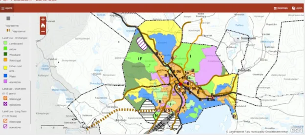
Figure 1: Ongoing in-depth overview comprehensive plan for Falun Territory and the Periphery - Land Use.
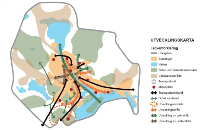
Figure 2: The map illustration of the development strategy.
(Source:https://www.falun.se/download/18.59208d97163622cf00ea76e/152646
4525699/illustration%20utvecklingsstrategi_20180110.pdf )
From the attached detailed map above is the development strategy depiction. “The development map describes the city's intentions regarding the long-term development and use of the plan area [8].’’ It shows the intended direction of future development and layout for which the expansion aims its focus on, and also the blueprint for ongoing planned housing development.
1.2 Objectives
This thesis aims to investigate possible measures on how the proposed new housing development features as an urban strategy with the potential for reducing car travel by smart growth. It focuses on residential developments, in such way, to be located in more optimal spatial pattern considering the effectiveness of transport. Hence, being considered a prospective city project, the research is adapted towards new housing development in Falun, concerning the transport system from energy and CO2 emission’s perspective. It’s to put into execution by examining the relationship between the transport system and residential development patterns or spatial configurations. However, the study is not only analytical or descriptive, but it gets influenced by normative or prescriptive concepts of sustainable urban planning in the present day; specifically, concepts relating to Smart Growth. It is much of research about urban form and transport energy use that departs from a normative standpoint of increased effectiveness, which is a political position, and in understanding how cities function by the distribution of travel, within the urban system.
1.3 Research Questions
The thesis needs to investigate theenergy use and carbon dioxide emissions in different scenarios, including the municipality´s (Falun city) own proposal for future development, so therefore, is the establishment of the following corresponding research questions:
• Will the proposal in the detailed, comprehensive plan lead to
transportation that is more or less energy-efficient than today? And Is the proposed development in line with previous empirical findings in the research literature?
• Can the amount of car travel be reduced by planning for a different
location strategy for future residential development in Falun?
• Can this analysis be made roughly using simple tools that are easy to
use for urban planners or architects (not only for advanced GIS-engineers and researchers)
2 Theories
To put forward convincing arguments for the significance and relationship between urban form/structure/land use concerning transport energy, by considering different aspects of urban structure (the five D´s) that are important in planning development. The selected fundamental theories and works of literature have been adopted for study, expressed further in details in this section. Additionally, the chapter provides part of the basis for author’s assumptions about trip lengths, number of trips and so on, and also served as part of the basis for comparisons in the other section of the report.
2.1 Densification
Densification today is a core planning trend that is essential in a city or urban planning and development, such that it provides potentials for achieving sustainable environment and transformation of the transportation pattern, which aids the reduction of air pollution from transportation greenhouse gases emissions. “Density and compact development are terms commonly used to imply smart growth development policies where density, mix, regional accessibility, and multi-modalism are involved [9].” In other terms, like “land use planning and zoning, density refers to the ratio and intensity of land use over a given area of land. Density specification could be by ratios such as the number of units per given area of land [10].” Whereas, in this case, which is of building and function, then the planning and development of a densified city is a crucial land-use parameter that is essential to influence the transportation system of such urban environment. Thus, “density increase promotes sustainable development through emissions reduction, as it, in one way or another result in reduced travel distance and aid good public transport provision [11].’’
As stated in an article, “urban containment, managed through a distinct boundary zone between urban and rural land use, is a common strategy for urban growth management and for attaining sustainable development focusing on efficient land use and the preservation of rural functions like ecosystem services [12].” Besides, the densifying trend has been an essential tool for planning a city or urban development, that gets along in place, according to a sustainable environment. It is also the case in the transformation of the transportation pattern, which aids the reduction of air pollution from transportation GHG emissions. From the attached image below is an example of land use with the planning concept of densification, which depicts a reasonable solution to planning and development according to the Department of Infrastructure, Melbourne.
Figure 3: Example of what could occur from the development strategy through densification. (Source: Melbourne 2030 Planning for sustainable
From the images above, the differences are visible when it comes to physical changes between two different planning conceptions. And to illustrate the point from the planning strategy and related performance from a sustainability point of view, additional information is summarised and listed in the table below.
Performance of the planning conceptions from a sustainability point of view
TYPICAL CAR-BASED CENTRE THE CENTRE AS DENSIFIED Large land areas allocated to car
parking wastes land and make pedestrian access on
foot inconvenient and less safe
Attractive pedestrian lanes with active frontages offer a safe, direct link between
shops, buses and trains Island of peripheral shops, difficult to
access without driving
Tree avenue enhances residential street amenity
Poor bus facilities and the bus doesn’t connect with rail or shops
New civic plaza with safe, convenient bus/train interchange
An original strip shopping centre
Higher development restricted to locations away from existing residential area and heritage ‘strip’ centre
Long, unprotected walk through the car park to get from the station to bus and shops
Offices, medical suites, etc. located next to public transport, away from existing
residential street Car-based supermarket development
added to the rear of a strip shopping centre
The second stage of a shopping complex with car parking underneath An existing residential street –
pressure to convert houses to offices, medical suites, etc.
New residential and office
development, built over car parking locates as many people as possible close to shops, services and public transport
Poor residential interface with shopping centre
Shopping and residential
development over railway cutting – fills the gap in shopping frontage Car parking underneath development The heritage railway station,
preserved
Cycle and footpaths
Streetscape improvement program New development with increasing height away from existing houses
Table 1: List for the planning conceptions of performance from a sustainability point of view. (Source: Department of Infrastructure, Melbourne
2.2 Eco-compact City
Hickman and Banister in their working paper claim that “an inverse relationship is found between residential population density and energy consumption: lower residential population densities are associated with higher energy consumption patterns, and higher densities with lower energy consumption patterns, in the commute to work [13].” Regarding the claim, however, it can be argued that despite population density of city inhabitants, “integrated transportation that focuses on intermobility with effective commuting of people, goods and logistics play a significant role in solving the challenges of congestion [14].” The solutions to these challenges, in which if city planning strategy embraces eco-compact development would ensure “people interchanging between bike, bus, train, car, and metro services as a result of convenient and time-saving transport system provided [14].’’
There is the possibility for such planning to be achieved, by planning with a strategy for an eco-compact city. According to the definition, “an Eco Compact City (ECC) is a city built and developed in balance with the natural environment. It is a city with clear boundaries, with an optimum ratio between density and network of open public spaces defined by urban mixed-use blocks. It is a city made of a federation of organic urban neighbourhoods and districts, but it can also be a metropolis. The optimum density that characterises the Eco Compact City allows the existence of a rich system of small retail while allowing the creation of an efficient public transit system [15].” A good representation for that description is a model from the Melbourne 2030 (attached below) “a continuous process of planning and implementation [16],” with the strategy for such planning solution.
In managing its urban population growth, the city “encourages the concentration of new development at activity centres near current infrastructure, in areas best able to cope with that change while meeting the objective of sustainable development [16].” With that such approach to development, it is paramount to work in line with a strategy that makes sure “growth management will be to produce an urban form that can be serviced efficiently so that public transport services are provided concurrently with development [16].” That exemplifies planning for sustainable growth with the model for an ECC, and such city planning is “physically organised according to a particular combination of open and built spaces, rich in facilities to satisfy the needs of the social life of its residents. A city is an organic polycentric system of neighbourhoods, districts, and villages [17],” and consideration must be given to every part combined from the central to the peripheries from a transportation perspective to achieve an ECC. Shown further below, as seen in the attached images, is the depicting of an ECC strategy.
“In an ECC, residents are encouraged to move about in a pedestrian-friendly environment that favours the use of public transport more than automobiles. ECC’s based its objective on providing a rich-interactive urban environment, where natural resources usage can be an effective measure in minimising pollution, of both the air and the natural landscape - according to ecocompactcity.org [15].”
Figure 4&5: Map showing planning and development strategy for Eco-Compact city in Melbourne (Source: Melbourne 2030
Planning for sustainable growth, October 2002)
2.3 Urban Configuration
The urban configuration is an essential aspect of urban structure from a systematic perspective with pros and cons, which is vital in achieving a sustainable planning structure. The term configuration is where “the root of the concept lies in the transitive verb to configure, which may be understood according to standard interpretation as “to set up something in such a way that it is ready for operation for a particular purpose [18].” Whereas, in urbanisation, this can be done and achieved in various ways and different patterns such as smart growth, sprawl, and so on. By its definition and implementation “in the most prosaic characterisation, a configurational approach can thus be seen as a precise attempt to answer the question: How are things put together? [18].” On the other hand, in smart growth, it refers to a sustainable planning and development consideration, that “can be regarded as a reduction of a larger phase-space covering all possible stages of a system [18].” The system, in this case, is referring to an urban area for social infrastructure including housings, schools, universities, hospitals, commercial buildings, roads and so on.
The term urban configuration involves the planning and management tool such as sprawling in which “the phenomenon of sprawl has been described in various ways, ranging from development aesthetics to local street patterns [19].” These, in several very well thought of ideas and reports within the planning sector, entails an influential foothold in city planning and development. Much so, wherewith the urban sprawl usually holds a significant impact and effect on the environment and socio-economic evolution of a city. Furthermore, it was “defined in the European Union policy documents as the extensions outside the core city of the residential zones, along with commercial and other various types of zones [20];”
On the other hand, by taking into consideration the fact that it has some traits of urban structure that affects transportation and energy use. As such, it is significant to the planning of urban mobility which is affected by density,
dimension, and design in the urban configuration. Research has shown,
according to Yin et al. that transport “from the physical standpoint, the urban spatial configuration and land use affect the total amount of energy consumption,” thus, justifying investigating the planning of urban spatial structures, together with its effects and consequences on transport energy use and emissions [21], [22].”
However, with a view on sustainable development for city planning, in the event of challenges that can be encountered from urban mobility when implementing a pattern such as sprawl for urban development. Eyes have been raised, where “at the same time, a few voices have been questioning the conventional wisdom that sprawl is bad and "Smart Growth" policies are the cure [23].”
It is of an opinion (as the author) that urban configuration is nonetheless significant to planning and development, and it is essential to bring in the concept of configuration. Even, if no other author considers it vital for urban planning, for me, it is, since it affects the relationship between the built environment and transport energy use (as mentioned in the introduction/background chapter). Research by Pavlos S. Kanaroglou and Robert South has indicated that the “relative influence of urban form, land use and spatial arrangement aspects of urban configuration increases Vehicle/Kilometre Travelled (VKT) in urban areas, with interacting activities such as work trips among other things, which can and does have an impact on transport energy use and overall rising on the emissions [24].”
This study conducted by Pavlos S. Kanaroglou and Robert South (2001-06-01), present results that demonstrate this point and support the arguments of previous related studies, using urban simulation model called IMULATE (Integrated Model of Urban Land use and Transportation for Environmental analysis) [24].”
Meanwhile, from the research of Lefèvre (2008), “through the application of an integrated ‘‘transport–land uses’’ model, TRANUS, it’s demonstrated that transit technologies can significantly curb the trajectories of energy consumption and the ensuing carbon dioxide emissions, if and only if, they are implemented in the framework of appropriate urban planning[22], [25].”
“Ensuring the coherent development of peri-urban areas is a key element in ensuring not only a high level of quality of life for the population but also a territorial cohesion for the hinterland, bringing into attention better management of the urban-rural relationship and limit the urban sprawl [20].” Moreover, as urban sprawl is an evolution of city development away from central urban areas towards low-density and arguably a territory that is likely dependent on cars, it is vital to take note of the adverse effects and ramification that follows it, such as higher percentage of GHG emission and various other environmental problems. That is, “if taken into account also the fact that it poses a threat to the intensively promoted sustainable development, one could see the importance of why we need to address and deal with it [20].”
However, despite being an aspect of urban structure that has adverse effects on transportation, energy use and so on, the sparse areas in the urban periphery are still desired in frequent use for city planning and development. To the understanding that “the causes are numerous, with relation to the smaller prices of the land in the peripheries, the desire for an individual living lifestyle, as well
as the multiplications of the forms of mobility, especially the increasing use of the automobile [20].” Meanwhile, present and future planning of a city should consider the importance of connections between urban structure and the efficiency of various means of transportation by giving higher priority and access to multiple modes of public transportation. “Be that as it may, as such, investment in public transport infrastructure is only economically justifiable if housing and employment density are sufficient within the catchment area of the stops [26],” that may come with the infrastructure of public transportation with impact on overall city development.
2.4 Transit-Oriented Development
The following literary text on Transit Oriented Development (TOD) focuses on design approach and strategies. The practices are good examples for providing solutions as seen further in the thesis, in building a sustainable city that create walkable, livable, vibrant, and mixed-use sustainable communities centred around high-quality transit systems.
There are various concepts and approaches in managing the dependency on automobiles. There are two crucial key initiatives enlisted in the World Bank Documents & Reports; as “shifting travel from private motorised vehicles to non-motorised and public transport, and reducing sprawl by promoting TODs that are served by high-quality public transit services [27].”
In its term, TOD is a normative planning concept that has developed as a response to urban sprawl (in the US and other western-world countries). It is one of several planning conceptions, but one which emphasises the relationship between alternative modes of transport (alternative to a car) and smart growth of the built environment.
In the United States, according to the Institute for Transportation and Development Policy (ITDP), the “transit-oriented development means integrated urban places designed to bring people, activities, buildings, and public space together, with easy walking and cycling connection between them and near-excellent transit service to the rest of the city [28].” These attributes of TOD are essential in the design and planning for flexibility and mobility in cities no matter the location in the world, in terms of sustainable and energy efficiency objectives. From another explanation, it discussed that “it means inclusive access for all-to local and citywide opportunities and resources by the most efficient and healthful combination of mobility modes, at the lowest financial and environmental cost, and with the highest resilience to disruptive events. Inclusive TOD is a necessary foundation for long-term sustainability, equity, shared prosperity, and civil peace in cities [28].”
To further strengthen the earlier description, Olivier Bonin and Lorenza Tomasoni defined the TOD concept “as an urban project; TOD can be conceived to revitalise the inner city or to improve the potential for residential renewal in decayed urban areas and suburbs [29].” The TOD, however, can be related to, in dealing with the undertaken case study as regards the project in which the thesis has been looking to address in the city of Falun plan development. TOD, perceived as a progressive trend, is a sustainable design approach that makes it possible to avoid the total dependence on the use of personal cars for mobility and livelihood. Also, it is a framework for a solution to the continued increase in global energy-efficiency and climate change problems, based on creating a living
arrangement that reduces the need for high-level usage of passenger/private cars and energy consumption in a dense, walkable community that is compact, coordinated, and connected.
Figure 6: Integrating Transit and Land Use toward Sustainable Urban Development; A tale of two cities: Built-up area of Atlanta and Barcelona, 1990 (Source: Bertaud 2003, taken from Transforming Cities with Transit - World
Bank Documents & Reports 2013)
From the representation of the attached image as an example, the authors explained that “Barcelona's energy use is considerably lower than Atlanta's. Because vehicle kilometres travelled per capita are much lower in Barcelona than Atlanta, far less fuel is consumed in the transport sector, and CO2 emissions are considerably lower [27].” And as seen from the text on the image, although not precise, it is interesting that the cities at the time of the publishing of the book were of about the same population size, but they broadly differ when it comes to urban built up-area, i.e. Atlanta 2.5 million people (1990), 4.280 km2 (built-up
area) and Barcelona 2.8 million people (1990), 162 km2 (built-up area).
However, a reasonable argument that this approach’s adoption is possible in the case of Falun locality is that; in the description of the result from the above study findings, the outcome favours planning with the integration of TOD as a sustainable approach to reduced energy consumption in urban development, and to make the normative concept legible. The comparison of the situation, i.e. “Atlanta, a sprawled low-density city, and Barcelona, a compact high-density city, show dramatic differences in their private car use, energy consumption, and environmental footprints [27]” as seen from the figure 9 above, which stimulates more interest for the current work of the thesis.
Also, a fascinating book by John L. et al., urging the global decision-makers globally and designers in the field of planning practices to embrace and put into effect the TOD approach, emphasised that “TOD facilitates increased accessibility because it provides alternatives to automobile-based land uses. It attempts, at the very least, to create a land-use pattern that facilitates transportation choice, which is increasingly important, particularly given today's complex lifestyles and business practices [30].”
Further, points on the arguments for the efficiency of TOD implementation are listed:
§ The TOD is vital in present-day planning, city revitalisation, suburban renewal, in the creation of walkable neighbourhoods and city, and human-oriented urban environment.
§ The TOD concept provides the benefits of desirable places for city inhabitant to live, work, and play in a sustainable quality urban environment.
§ “TOD is reasonably practicable towards efficient, sustainable, and equitable communities. Considering that it prioritises the “3Cs”: compact, coordinated and connected. By following a TOD approach, decision-makers and urban planners can strengthen their communities [31].”
Furthermore, as understood, “TOD occupies an important place within the smart growth movement. It posits the restructuring of regions towards greater use of public transport by improving or creating light rail or rapid bus transport systems and generating dense mixed-use nodes around transit stations [32].”
Although most TOD concepts concerning large metropolitan areas in large cities are usually connected to rail, it is understood that TOD can also be used as a concept for bus line as well as tramline development, even though not all situations in every city are fit for TOD. Much so, in the TOD approach, accessing reasonable walking distance is a significant factor which; according to the Regional Plan Association (1997), in the qualitative studies made by Planning Commission TOD Committee for the Walking Distance Research. Where it explore the knowledge to “defines transit-friendly communities as intensively developed areas within ¼ - ½ mile of rail stations, that is, a distance that is possible to walk comfortably in 5-10 minutes and a distance most people are willing to walk to train stations or other community uses [33].”
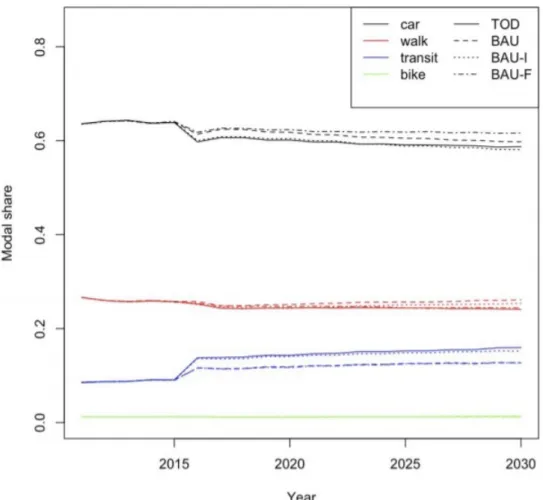
However, a study by Olivier Bonin and Lorenza Tomasoni has shown how a medium-sized city such as Falun can benefit from a TOD approach for its development. Using Besançon in France as a case study, by designing four (4) scenarios and evaluating them with a Mobisim; a LUTI (Land-Use Transport Interaction) model as seen in the attached image below. Mobisim is the LUTI model used to simulate daily mobility as
well as residential mobility1.
1Mobisim is an agent-based model that create a synthetic population for the whole city and simulates their
behaviours. Mobisim enables us to assess the efficiency of a scenario according to several criteria. Source:
Figure 7: Modal shares for car, walk, transit and bike in the four scenarios by Olivier Bonin and Lorenza Tomasoni, 2015. (Source: International Journal
of Transportation)
They designed four scenarios to reveal relevant views on the potential of local and regional TOD for a medium-sized city and evaluated them through simulations. Their results show that “a public transportation network project has a definite effect towards sustainable urban mobility by increasing the modal share of public transport to the detriment of private cars [28].” Further, with an explanation that from the various scenarios, which includes transport policy and land use policy, "the TOD scenario is the only one that gives positive feedback on all aspects:
- car dependence is reduced by 1% (not very much percentage [%] but could increase significantly in the case of Falun with proper systematic strategy, while this is a moderate contribution to decreased car use, it is still a decrease while several other scenarios including the present development trend probably would lead to a significant increase instead).
- the use of public transport is enhanced not only in the centre but in rural areas too,
- urban development kept controlled, preventing urban sprawl without conducting concentrate densification of lands
- households satisfaction increased (even if a little bit less than for the BAUF) Therefore, the TOD scenario enhances the success of integrating and harmonised land
use and transport policies [28],” a plausible argument to reflect upon for the value and benefit it could serve in its implementation for the undertaken case study.
Meanwhile, concerning TOD as regards city planning and development, the term as explained “Smart growth supports the intensification of urban development and attempts to limit growth beyond the urban edge. It encourages increase in density; mixed-use and cluster developments; a variety of housing types beyond detached units; protection of open space, agricultural lands and ecologically sensitive areas; the reduction in use of private and motorised forms of transport; the promotion of transport systems; and the design and redesign of areas to support such use [32].”
2.5 Smart City Approach - Infrastructure and Transport of the
Future
The unfolding text on Smart city approach consists of several combined sources of information gathered through investigation on comparable development and planning. It also includes information and findings that support the work on the thesis (questions), and the yardstick for the suggestion of planning proposal in the Falun locality case at hand.
In order to reach sustainable development in the process of planning extension with a view on transport energy and efficiency, it is, therefore, perceived to be conventional that the provided information could be vital with contents to work with for planners and decision-makers. Thus, divulging this purposeful information and content to be expressed further in the report, considered to be valuable measure with a point on the strategy to reflect upon, as well which could be functional in future city and or urban planning and developments.
In a proper approach to strategic planning for achieving a sustainable city, one substantial way is through the means of smart city approach, as “smart growth supports the intensification of urban development and attempts to limit growth beyond the urban edge [32].” With that in mind, the smart city approach has been, therefore, deemed as an essential tool, knowing that it is undeniable that urbanisation will continue to face the challenges of increased population in cities. Whereas, these particular challenges of increased population in cities often raises many issues for architects, planners, as well as decision and policy makers. These are regarding the effects of those challenges in connection to climate change, energy efficiency, infrastructure, health and safety, mobility and transportation, and many more.
Meanwhile, a step in the right direction with the development and combination of new ideas and technologies (with eyes on the future) offers encouragement, for a better quality of life with present and future solutions in the form of a well-designed and planned city that adopt some part of smart city strategy to tackle and implement smart growth efficiently and effectively.
Looking into it, one notable smart city strategy example of a considerable system is from an Urban Transport Theme Champion with the global Transport Knowledge Partnership (gTKP), where P. Midgley published an article about Smart Bike-sharing Systems in Urban Mobility. He discussed that “the latest systems operate with smart technologies and provide users with real-time bike availability information on the internet. These “smart” bike-sharing systems
provide the missing link between existing points of public transportation and desired destinations, offering a new form of mobility that complements the existing public transport systems [34].” As in the case of Falun locality, this is relatable. With proper planning and adaptation, such smart city strategies like bike-sharing could be a part of scenarios that lead to lowering energy use for transport by changing modal split.
Additionally, through several paper reviews while reflecting on experiences in various European cities. It became known that the adoption of such initiatives is a way of achieving a reduction in CO2 emission, efficient free, cleaner and safer city. Whereby, putting such initiative into practice can only be beneficial, without the need to compromise everyday health and life of the city inhabitants, as well as the future sustainability of such a city, with the implementation of the signified initiatives. “In general, bike-sharing systems are introduced to increase mobility choices, improve air quality and reduce congestion [34].”
3. Methodology & Research Methods
Methodology
The case study approach has been through the conducting of interviews and several studies, wherewith, an indication that huge potential for reducing car travel by smart growth is to be put to use for work on the detailed, comprehensive plan for the city of Falun. The reason for choosing to do this type of interviews was mainly to allow for credible information and explanation in the entirety of the thesis work. Thus, responses and data to be obtained from these studies, i.e. the indicators will, therefore, prompt efforts whereby this current study will focus on analysing effects of such planning strategy for developments and travel demand by experimenting with a calculating tool (TRANSCEN Model). That of which using it have the possibility to achieve a basis for localisation strategy for Falun locality, where decisions for locations of residential development in a more optimal spatial pattern would consider the effectiveness of transport. “As such, putting forward the conception to enhance dialogue and cooperation between the citizens, policymakers and local authorities, the approach looks to integrate system solutions, and the management of municipal infrastructure in a better way [35].’’
One benefit of case study methodology is, according to Yin, 2009 that it “allows for different methods of gathering empirics (such as interviews and literature reviews) and adding these to a rich material on which to make analyses and draw conclusions abductively [36].’’ Also, from the paper by Rolf Johansson, 2003 “Conference paper of Methodologies in Housing Research”, various features of case study methodology have been highlighted and explained in terms of how to combine different methods and implement them into research [37].’’ Thus, according to these descriptions, comparison of cases is one of the perspectives to focus the strategies of methodologies on, within the framework of the case study.
Furthermore, as interviews have been an essential part of the case study, which represents a qualitative research technique, it is further expressed, according to C. Boyce and P. Neale (2006), with their definition of an interview as “conducting intensive individual interviews with a small number of respondents to explore their perspectives on a particular idea, program or situation [38].” Besides, a paper published by Hamza Alshenqeeti as regards to what Dörnyei has argued (Dörnyei, 2007; Hamza Alshenqeeti, 2014), have the explanation that “interviewing, is ‘a natural and socially acceptable’ way of collecting data as it can be used in various situations covering a variety of topics [39], [40].”
However, the conceptual framework for methodologies according to a case study methodology is described by Johansson, which state that there are “three strategies to focus empirical research by reducing the units of analysis (cases), the number of variables (qualities), or both. The three strategies imply different methodologies [37].”
• Reductive • Experimental • Explicative
One case can consist of several analysis units; therefore “case studies are a form of explicative strategy [37].” Thus, in this thesis work, handling of the planning strategy for the development in the city of Falun has been taken as one case. It
is so, due to the insight that; the project can serve to explain logically, with plausible results, what the planning strategy entails for development and energy efficiency in the city of Falun.
Meanwhile, according to the perspective of Donald Schön (1991), “a designer’s work is based on comparisons between known cases from the repertoire and the actual design situation [41].” Thus, also has been the adoption of such idea in this thesis, and it operates through with the planning and designer’s perspective or methodology that has permeated the methods, as well as the results for the project - whereby the analysis of the city of Falun’s case has been executed.
3.2 Research Method (Gathering empirical material and
performing analysis)
The interviews, as a research method employed, are to have a broader view and understanding of the project from those involved in the planning and processes of the comprehensive plan for the development. The most significant of all in the interview has been with two municipal officials and partly few inhabitants that have provided additional information. The questions prepared for the city personnel (experts) are in the field of planning, design and design consideration, also energy efficiency, CO2 emissions, transportation, and sustainability. Further, discussion on the specific urban design strategy has been highlighted, with the ultimate topic based on new smart growth and sustainable city development.
Meanwhile, during the interview session depending on respective interviewee’s answers, there has been an improvisation. Some questions were left out and some new ones brought in along the way, as it has been found objective to complement the process and subject in question. Moreover, these occurrences have been perceived as operational regarding interviewing techniques, which has been deemed as ideal to be put into practice for the thesis work.
Additionally, there has been literature reviews and investigation of notable projects for corresponding solutions, and in developing an urban development scenario for Falun, by following the Smart Growth theories in the literature reviews. Afterwards, assumptions have been made based on the works of literature and the amount of travel generated from the planning scenario; i.e. assumptions about the modal split for the three scenarios, then proper comparison follows between the existing situation, the city's ongoing plan and the designed alternative urban development scenario to achieve a more optimal planning proposal. Further, the project proceeded with the application of the materials in calculating energy use and CO2 with the experimented calculating tool.
3.2.1 - Document analysis
The thesis involves studies and analysis based on plans and information, about the city of Falun development project (the unit of analysis). Therefore, there has been a look into the documentation and analysis of the proposal for the prepared ongoing detailed, comprehensive plan as a starting point. The documentation analysed has been part of the basis to navigate the work on the thesis and aligned together with reviewed literature as well as the consideration for the outputs from the calculating tool. The combination of all these significant factors has led to the development through the work on the thesis.
3.2.2 - Qualitative assessment of indicator analysis using quantitative data
There has been the exploring of a more indicative approach as a form of experimentation, open to manipulation using qualitative assessment “on naturally occurring circumstances but is dependent on quantitative data [37]” of different urban properties of urban form as cited in work by Ewing & Cervero, 2010. These data can varies in there form, and in this case “are factors that impact land use, in the frame of density, diversity, design, distance to transit and destination accessibility (Ewing & Cervero, 2001; Ewing et al., 2009) [1]” that serve in such way as ‘indicators', as a kind of relative evaluation of different structural proposals. Whereas, the “indicators are measurable signs of progress. An ‘indicator' implies or suggests (or indicates) progress rather than proving it beyond doubt [42].” “Generally, indicators frameworks begin with fundamental concept clarification, as part of the work that represents analysis and policy rationale against which the indicators are to be applied. While the concept of 'sustainable development', 'quality of life' and 'social inclusion', with various interpretations, are in planning policy dialogue [43].” A key example, in this case, involves the use of indications from a distance travelled by different transport mode and the resulting CO2 emissions, during the year 2016 in Falun locality as shown in the maps below.
Mapping of CO2 emissions from passenger cars, buses and railways (as an indicator) within Falun locality in the year 2016
1. 61620 ton/yr/km2 - Cars ǀ 2. 3336 ton/yr/km2 – Buses ǀ 3. 495 ton/yr/km2 - Rail
Source: Lansstyrelsen.se/dalarna/:lansrapport_dalarna_falun CO2 emissions.
3.2.3 - Secondary data from the site visit and interviews
There has been a combination of some secondary data, utilised as a method in the report, with site visits that mainly have provided significant extended view and perspective into the study. They have been developed, along with the holding of interviews with the planning practitioners, city staffs and inhabitants (house and apartment owners) connected to the ongoing-planning development. There have been further steps with follow-up consultations. It was to strengthen further, the required information, knowledge and understanding necessary to be able to achieve well-and-thorough details, needed to fulfil the thesis work. Also, all this has been done and interpreted in relation to field study further in the report.
3.2.4 - Literature review
In the thesis, the primary undertaking of the literature review as a method has been to be able to understand the project thoroughly, to obtain general information about the Falun locality’s urban development. The history and the planning system plus other facts, as well as issues related to the city, including initiatives, has been sought through databases found available at the city of Falun and Dalarna University, as well as internet searches. Also, in general, textbooks, articles, conference and scientific journals, as well as reports, were selected for respective studying by their credibility and standards. Additionally, are the visited webpages which were regarded depending on origin and ownership which means, for example, any webpage not associated to an official agency, such webpage must have sources for the listed content and the information on dates of updates. The webpages that belonged to official agencies, the likes of governmental organisations or credible authorities, e.g. Statistics Sweden (SCB) and so on are considered more to be valid.
Furthermore, based on literature and previous research, some hypothetical development patterns and or spatial configurations were investigated. Thus, are the related theme (the relationship between transport system and residential development in focus) that can correlate to the connection between ongoing planned development and criteria for an energy-efficient urban structure as stated in the reviewed works of literature.
The selected keywords employed in the process were: ‘transportation’, ‘sustainable’,
‘smart city’, ‘urban development’, ‘energy’, ‘CO2 emissions’, ‘mobility’, ’built environment’, ‘travel’, ‘strategies’, ‘analysis’, ‘residential’, ‘densification’ and various combinations of the words in different approaches. To be clear, the works of literature presented further in the thesis report is a part of the results for the thesis work.
3.2.5 - Calculating tool (TRANSCEN Model)
There has been the usage of data in the thesis work for scenario calculations, and the computation/simulation done, are through the means of the calculating tool described below:
The calculating tool called “Model for calculating energy use and carbon dioxide
emissions in different scenarios”, with focus on transport has been selected as
the form of method to be utilised due to its multi-purpose nature, as it can cover a wide range of information input and different scenarios which can be followed gradually and carefully from one stage to the next, and further stages beyond. Also, it has been adopted for experimentation to evaluates the emission of GHG within Falun locality, whereas been considered with assisting in understanding the alternative strategy for planning and development project in Falun.
This tool is a device, designed for evaluation of the emission of GHG, and to calculate the energy use and net emissions (loss) of CO2 in absolute numbers/terms from different vehicles and travel modes in any locations for an urban environment. The utilisation involves indicating and processing of information such as; the average data about percentage distribution on average means of transport (travel mode), and the average occupancy in the respective modes of transport, among others. However, there are pre-settings in the tools, based on some national average for some values and figures which serves as
restriction and limitation in the usage of the tool. Also, the scenarios in the pre-settings of the tool are not spatial, i.e. for example, they do not consider configuration or population density. Thus, leaving the assumptions about the impact of configuration in the alternative proposal and the city of Falun’s ongoing plans to be of crucial importance. These have resulted in the reviewed literature to serve as a basis for the assumptions in the study with consideration to the topography and the local situation in Falun locality.
The calculating tool (TRANSCEN Model) as partly elaborated by Ranhagen Ulf (a guest professor at Dalarna University and chief architect at Sweco), comprises of various assumptions as parameters with the opportunity to assess and calculate different conceivable combinations of conditions and measures. Such as; fuel consumption and carbon dioxide emissions in the locally adapted scenarios. These scenarios comprise of the listed assumptions below:
• “Assumptions for the distribution of transport in each scenario
• Assumptions for the total transport volumes (local & regional) in the city/place/location
• Assumptions for the distribution of public transport between buses and trains • Assumptions for future technology improvements that may lead to a decrease in fuel consumption and reduced emissions
• Assumptions for the number of passengers per vehicle [44; author’s direct translation]’’
Leif Magnusson of Magnusson Miljökonsult and Utbildning AB invented the calculating tool. A mechanical engineer with specialist consultancy in public transport and the environment, environmental requirements in public procurement of public transport,
environmental and climate strategies, environmental impact from transport, as well as fuel strategies. Leif Magnusson owns the rights to the calculation tool. The tool has three scenarios with a focus on data input from the usage of private cars, public buses, trains, bicycles, and walking in a specified location, city or urban environment. An illustration of the tool is shown further below as an attachment.