Approaching the Gotlandic Bronze Age from
Sea. Future Possibilities from a Maritime
Per-spective
Joakim Wehlin, University of Gothenbourg/Gotland University
Abstract-Although the Bronze Age is a period when travel and interaction over large areas has been intensively discussed, not least in the Baltic Sea, the role of seafaring and maritime knowl-edge in the society has seldom been considered. Maritime archaeology has been viewed as periph-eral in the archaeological discussion. The sea has been considered as a boundary when interpreting landscapes. More recently a maritime cultural landscape, a seascape, has developed in the archaeological discourse. In this paper I aim to apply and discuss such perspectives in the Baltic Sea region during the Bronze Age, with particular focus on the Gotlandic stone ship settings and their place in the secular and ritual landscape/seascape.
Introduction
In this paper I aim to use a maritime approach to find new ways to interpret certain ele-ments of the Gotlandic Bronze Age (c. 1700-500 BC). I find it quite surprising that the maritime perspective often is overlooked when interpreting the Bronze Age period, es-pecially when considering Gotland, which is an island in the Baltic Sea. The Bronze Age is also a period when travel and interaction over large areas has been intensively dis-cussed by archaeologists and the ship dominates the symbolic world.
Interactions and overseas contact required movements over open water or possibly ice. In previous archaeological research the sea has generally been discussed as a boundary. The maritime archaeology and seascape has been viewed as peripheral in the discussion. However, in recent years, Christer Westerdahl (1996, 1998, 2005) has argued for an extended use of maritime archaeology terminology when analysing the prehistoric social organisation. He, for example, stresses that the Baltic Sea is a social arena and considers the seafaring as a social action. People living by the sea, and who were possibly tied to a maritime institution, have very likely created beliefs, myths, and gods that are inspired by the sea.
In a recent dissertation, Johan Ling (2008) argues for a maritime understanding of the rock-art in south-western Sweden (Bohuslän). The large quantity of rock-art observed on the Swedish west coast is not found on Gotland. Instead another feature of interest appears on Gotland during the Late Bronze Age: the stone ship setting. This monument I will simply refer to as “ship setting” eliminating the prefix “stone” for the sake of sim-plicity.
In the study below, I will discuss the seascape of the Baltic Sea region during the Bronze Age in general, and the ship settings on Gotland, their monumentality, and their place in
the secular and ritual prehistoric landscape/seascape in particular.As a “case study” I use the north-east area of Gotland where a water system is located. It includes the largest river on Gotland known as the Gothem River, which in turn includes the Hörsne River and continues through the wetlands of Lina bog. It runs north-east and has its outlet in the sea at the bay of Vitviken. The area holds the largest cluster of ship settings on the Island, including the well-known grave of Tjelvar; known in the sagas as the founder of the Gotlandic settlement (Nihlén 1928).
This article is inspired by three different papers I have presented at the Nordic Graduate
School in Archaeology, Reykjavik, Iceland (August 2008); the 14th Annual Meeting for
the European Association of Archaeologists, Valletta, Malta (September 2008); and at the Baltic Rim Seminar in Visby, Sweden (October 2008).
Maritime Archaeology
Traditionally maritime archaeology has focused on ships and their technology and func-tion (e.g. McGrail 2001). Keith Muckelroy defined it as “The scientific study of the material remains of man and his activities upon sea” (1978:4). Maritime archaeology has earlier been viewed as a marine specialisation. The archaeological questions that it could answer became peripheral in the academic discussion. The sea was considered a bound-ary/obstacle when interpreting landscapes. The coastal zone and the maritime environ-ment were thus reduced to an in-between space. This narrow interpretative perspective has been discussed by Westerdahl who introduced the term Maritime Archaeology (1978) which replaced the former term: Marine Archaeology (1996:2). Muckleroy (1978) has also raised the question of whether there is need for a theoretical maritime archaeological discourse regarding a maritime cultural landscape (seascape) as is cur-rently evident (e.g. Westerdahl 1996, 1998, 2005, Ballard et al 2003, Rönnby 2003, 2007, Nordenborg Myhre 2004, Farr 2006, Kvalø 2007, Widholm 2007, Ling 2008. When studying maps of suggested prehistoric diffusion, there are arrows pointing in various directions, borderlines drawn, and areas marked in different colours suggesting the spread and appearance of artefacts and raw materials (Farr 2006:86pp). Often the space in-between is filled with water. Material was circulated, but people carrying these objects, their individual and cultural knowledge, their skills and beliefs are usually only briefly discussed. One may ask what role seafaring and maritime knowledge played in the society and social organisation, especially on Gotland with its insular status. Accord-ing to Robb and Farr (2005); what archaeologists consider “… ‘trade’ may often be a by-product of travel and interaction undertaken for other purposes” (Farr 2006:90).
Bronze Age Ships
Until present, just a few seagoing vessels from the Bronze Age have been found in con-nection to the Baltic Sea (Rieck 1995:125, Sylvester 2006:101-102). In fact, one part of a prehistoric vessel was recently found on Gotland. It was a 4,5 m long and 0,4 m broad
dugout found in the Martebo bog in Lokrume parish in 2002. The 14 C –analysis, cali-brated at two sigma, gave the dating to the Late Bronze Age- Early Iron Age c. 720-390 BC (Figure 6). According to the dendrochronology report, the age of the wood was con-sidered to be 140 -160 years. However, this period in prehistory shows the ship as a dominant element of the visual culture; carved in stone, decorated on bronze artefacts or built up as stone constructions. These ships, or boats, have according to Ballard et al (2003) divided the scholars in mainly two camps. One perspective highlights the practi-cal explanation considering the advantages of travel by sea rather than moving over land. The ships visualised in different media may refer to factual ships and the variety could indicate different functional ships (Rausing 1984, Capelle 1986, Berntsson 2005). It is furthermore suggested that the area to a certain extent was dependent on southern metal sources (Glob 1969, Malmer 1981). The lack of copper and the large amount of depos-ited bronze artefacts in the Scandinavian Bronze Age suggest that the raw material (or objects) must have been imported. The style, which can be seen on many bronze objects of the region, show similarities with bronze artefacts in central and north-east Europe (e.g. Kristiansen 1987, Larsson 1994). With this perspective, the maritime connection has primarily been discussed in relation to economics and politics (e.g. Randsborg 1993, Earle 1997, Kristiansen 1998). The other viewpoint implies a cosmological approach to the discussion stressing the importance of placing the ship in context, not referring to interaction, navigation and long distance exchange, but seen in context with other fea-tures such as graves and bronze deposits. Flemming Kaul (1998, 2004) has for example developed a Bronze Age cosmology based on the journey of the sun. He uses a quantita-tive study of depicted scenes on bronze artefacts, mostly razors from Denmark, where the ship appears as the helper of the sun. The relationship between ships and circular motifs, usually interpreted as the sun, is also visible in Scandinavian rock-art. The dis-cussion of a Bronze Age sun cult and the journey of this heavenly body had its starting point in the studies of rock-art scenes by Oscar Almgren (1927) and subsiqent studies by Åke Ohlmarks (1963). The rock-art, depicting ships, also appears in places where the boundary between sea and land has a unique role in local cosmology as a meeting place between the living and dead (Helskog 1999, Nordenborg Myhre 2004:177pp, Ling 2008:232pp). This meeting is also noticed in the long lived tradition of burying people inside boats, which may go back to the Mesolithic period (Skaarup 1995) continuing on in graves formed as ships or boats (Artelius 1996). The rock-art panels with depictions of ships also demonstrate close relationships to burials (Ling 2008:154). A relationship between ships and burials is also found in the well documented graves of Kivik and Sagaholm, where images of boats have been found inside the grave (e.g. Randsborg 1993, Goldhahn 1999, 2005).
These two approaches should, as Ballard et al (2003:385-386) argue, complement one another other, but have not done so over the years. More recently, Kristiansen and Lars-son (2005), discuss the significance of travels and sea journeys in the political and cos-mological order of Bronze Age society. They are influenced by the work of Mary Helms (1988), who argues for a relation of geographical distance and the value given to ideas
and goods obtained through travel. This discussion of long-distance maritime travel beyond the mechanical and physical aspects of interaction has, as I mentioned earlier, increased during recent years, especially by research in the British Isles. This includes contextual landscape analyses by finding sites of Bronze Age boats at North Ferriby, Dover, Kilnsea, Caldicot, and the River Test (e.g. World Archaeology 2004, Clark 2004, 2009). In this paper I will use the maritime and seascape perspectives to broaden the discussion of the Baltic (Gotlandic) stone ship settings. These monuments are so often clearly associated with burials. This will hopefully contribute to the discourse and re-interpretation of some aspects of the Gotlandic Bronze Age in a contructive way.
The Gotlandic Ship Settings
Approximately 380 ship settings are known on Gotland and c. 70 of them are excavated to some extent. The feature is traditionally dated to Montelius period IV-VI (c. 1100-500 BC) and interpreted as graves for one or several individuals (Hansson 1927, Pettersson 1982, Capelle 1986, Artelius 1996, Hallin 2002). They are located mainly along or close to the coast-line. The number of ship settings at each site varies, from one solitary ship to up to nine vessels in close connection.
There are large variations seen in the appearance of the Gotlandic ship settings. Harald Hansson (1927) makes an attempt to explain the variation with chronology and change over time. This is an explanation subsequent scholars have discussed and used to under-stand the phenomenon and its variation (e.g. Nylén 1958, 1972, Capelle 1986, Artelius 1996, Skoglund 2008). These researchers have focused on the phenomenon itself and raised questions concerning the ship as a symbol in both the religious and everyday life. Still there is no evident explanation of the large variation observed in the ship settings, even though some differences and change can be explained by chronology. It seems more likely that different types, that we today entitle as ship settings, were in concurrent use during the Late Bronze Age.
The Gotlandic ship settings succeeded the prominent cairns of the Island as manifesta-tions and burial grounds. Even though these stone ships seem to appear “from nowhere” in the landscape it is relatively clear that the cairns were still in use (as burials) during the Late Bronze Age (Hallin 2002:85). The ship setting tradition appears at the same time over a large geographical area; from the Baltic Sea region to the south-west of Sweden, and also to a certain extent in Denmark and Norway (Capelle 1986, Artelius 1996, Skoglund 2008, Wranning 2006). The cultural expression of making stone ships is initiated at the approximate time of the Montelius period III and corresponds chronologi-cally with the change to the cremation burials. The relationship to and treatment of the dead change in the Late Bronze Age phase. Tore Artelius (1994:54) point to the fact how well the symbolic ship fits the tradition of cremation burials as the vehicle for the dead on their journey to the “underworld”. This tradition might also have communicated a new way of viewing the transition of the soul, as a journey from the body to the “other side”. Although this interpretation seems reasonable, it is clear that even though the
bodies were cremated not all were buried in a ship. Important to consider is also the fact that no burials have been found in 14 of the 54 properly reported excavations of ship settings on Gotland. Regarding the emergence of the ship setting tradition, Artelius (1996:64-65) discuss their appearance as a result from distant cultural influences. The areas of origin might, according to Hernek (1994:19), be discussed in association with the Gotlandic house urns, which are similar to those in central Europe. On Gotland these urns most often are found in ship settings (Arwidsson 1952, Pettersson 1982, Sabatini 2007).
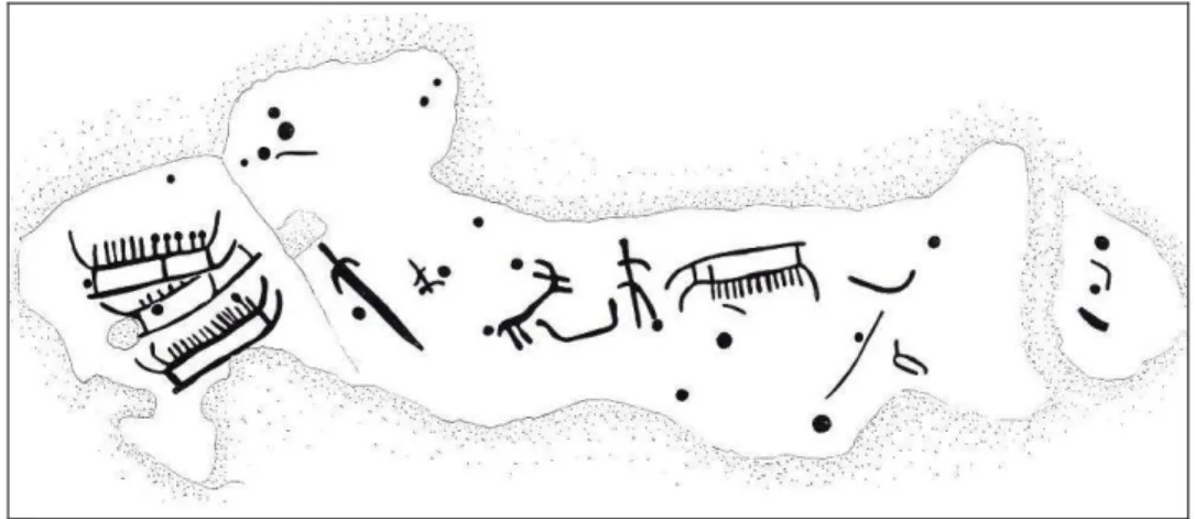
It is of course impossible to overlook distant influences as we see a wide distribution of the ship symbol in the Scandinavian Bronze Age. Depicted on bronze artefacts and in rock-art the ship is the dominating symbol of the period. In Central Scandinavia, from the Lake Mälaren area in the east, to Bohuslän, Østfold and Rogaland in the west, the ship is an important component in the rock-art (e.g. Malmer 1981, Coles 2005, Goldhahn 2006). In South Scandinavia, ships are engraved on bronze artefacts (mainly razors), with a distribution mainly in Denmark (Kaul 1998, 2004). On Gotland, on the other hand, no artefacts of bronze with depictions of ships are known and only two rock-art sites with ships have been found, one on Fårö (RAÄ no 379:1) (Figure 1) and the other in Lärbro (RAÄ no 303:1). The ship expression instead appears as ship formed stone settings here.
A Maritime Institution
Placed along the coast on the Ancylus and Litorina transgressions (Hansson 1927:63) the ship settings show the same geographical distribution as the large stone cairns, but there are also cairns with a distribution reaching the inland water systems (Stenberger 1945:58, Hallin 2002:19pp).
The relationship between clusters of Bronze Age monuments and places like inlets and river-mouths, which were suitable for seafaring, was stressed by Erik Nylén already in 1959. In his proposed research program concerning the Gotlandic cairns and a Bronze Age long distance trade, Nylén recognised a possible maritime institution (1959:25-26):
”It is tempting to divide the Nordic Bronze Age into what fiction might refer to as ‘two cultures’. One trading culture, concentrated on the coasts and in the areas of political, commercial importance. This culture has many differences, but also similarities with the second culture, the inland culture, belonging to the stock-raisers and farmers who hungered for Bronze, which enabled the ex-istence of the trading culture. “(My translation).
Hallin (2002:26) furthermore discusses the possibility that the few rock-art locations on Gotland may indicate meeting places for people travelling to and from the Island, places where goods could be exchanged, and where sharing of ideas, knowledge and ideologi-cal beliefs may have taken place.
It is noteworthy that the two rock-art sites with depictions of ships found on Gotland are located in a maritime environment. Both of these panels can be dated to Montelius pe-riod III, at the latest, by means of the depicted ships (e.g. Glob 1969, Kaul 1998, Ling 2008, Malmer 1981, Goldhahn and Ling, pers. comm. 2009). This early dating, places the rock-art panels in line with the traditional view of the first appearance of the ship settings. It is of interest here to emphasise Harald Hansson’s (1927:86) view of that the idea of carving ships in stones transformed on Gotland to the actual building of stone ships in full scale models.
When studying ship settings closer, I argue that we should abandon the idea of the ship settings as simple burials related to the death cult in favour of a more contextual under-standing using a maritime perspective. In line with Capelle’s ideas (1986), I suggest that the ship settings be placed in the context of a maritime social institution.
Lina Bog and the Gothem River
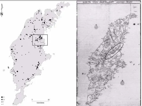
When studying historical maps from the 17th and 18th century Gotland appears as a “sea/water” landscape (Figure 2, Right). There is an inland landscape consisting of water mirrors, wetlands, rivers etc. This “sea/water” landscape has also changed over time by the complex shore displacement due to isostatic uplift. By examining the Litorina trans-gression, created during the Litorina phase of the Baltic Sea (maximum 5000 BC) (Bu-renhult 1999:193 pp), it is possible to gain insight into this change. Harald Hansson makes an attempt to re-create a possible Bronze Age shore-line by using 20 % of the Litorina transgression as standard for the isostatic uplift after the Litorina maximum (1927:90pp). The major uplift has taken place on the north-west part of Gotland with the least effect seen on the south-east part, indicating a difference of c. 10-15 m. Hansson estimates the Bronze Age shore-line to c. 5 m.a.s.l. in the north and 2 m.a.s.l. in the south. This interpreted shore-line seems too low when examining the visible prehistoric
Figure 1.... Fårö 379. From Broström 1999 (Permission by e-mail 2009-11-20).
remains traditionally placed in the Bronze Age. The large cairns situated on the moor-land at Uggarde, Rone parish (south-east Gotmoor-land), including the prominent Uggarderojr, are all located above the 7,5 m elevation (Martinsson-Wallin and Wehlin, 2010). The Litorina maximum in the same area measures 16 m.a.s.l. (c. 47 % ). If instead applying that percentage as standard of Litorina maximum, it gives a shoreline on the northern parts of the Island of c. 12 m.a.s.l. during the earliest phase of the Bronze Age (Sardén Johansson 2009:19). Another aspect of landscape change to consider is the fairly rapid change of the inland “sea/water” landscape that took place during the drainage cam-paigns in the 19th and 20th centuries with the aim to increase the arable land for cultiva-tion.
One interesting water system that appears on the historical maps extends from the central inland parts of the Island in a north-east direction to the Bay of Vitviken (Figure 2.
Right). There is a hypothesis of the existence of an old sailing-route along the same
water system (Ohlsson 1984:30). Even though this hypothesis have to be evaluated, interesting relationships emerge when examining the spatial distribution of the Gotlandic ship settings.
Figure 2. Left: Spatial distribution of ship settings and the “case study” area (marked rectangular). Right: Carta von Gottlant:1646. Historical map of Johan Meyer (eg Johan Fredrik Meijer).
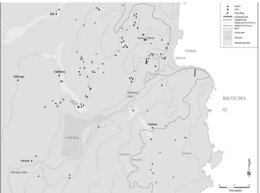
When examining the spatial distribution of the ship settings a couple of clusters appear and the most distinct of these correspond with the aforementioned water system (Figure 2). This area is located in the north-east of Gotland and in the parishes of Boge, Gothem, Hörsne and Vallstena. In the central parts of the Island the water system consists of the Hörsne River which later becomes the Gothem River (the largest river on Gotland). The river runs north-east through the wetlands of Lina bog, and continues to its mouth at Åminne and the Bay of Vitviken into the Baltic Sea (Figure 4). The Lina wetland was, prior to the draining campaign in 1947, the largest on Gotland, c. 900 hectare, including the Lina bog and Råby (50 hectare) (Sernander 1939:250pp). Today the area consists of farm land and wetlands, which floods during the winter season and is reminiscent of a long gone water supply (Figure 3). This area appears as a maritime landscape with a large inland wetland, bogs, river-systems, river-mouth, coast and sea situated in a rich Bronze Age landscape. The area might also have been important as a communication link between the east and west coast through historical times. I believe that it is not a coincidence that one of the largest clusters of ship settings, almost 15 % of the total number of such monuments, appears here.
The Uppgarde Ship
When examining the spatial distribution of the ship settings in the “case study” area (Figure 4) one immediate pattern stands out. Out of 54 known ship settings only 6 are located south of the Gothem- and Hörsne rivers. Also the cairns show a clear spatial dominance north of the river. Even though most of the ship settings cluster towards the coast, one interesting area is located north of the former Lina bog marked on the map (Figure 4) and is known as the Uppgarde Ship site. In the vicinity of this site two cairns located at Nygårdsrum in Vallstena parish (RAÄ No. 73:1) was investigated during the 1970´s. The smaller stone setting, measuring 12 m in diameter, contained a stone cist with approximately ten buried individuals and numerous artefacts including a flint dag-ger. The larger monument (30 m in diameter) contained a complex inner construction
Figure 3.... Left: Lina bog. Photo from Lina-burgen: Joakim Wehlin 2008. Right: The Gothem river. Photo: Arvid Ohlsson (nd.) The Gotland Museum (Permission by e-mail 2009-11-24)
with nine concentric circles surrounding a stone cist containing three buried individuals. After the stone packing was removed, a smaller burial ground appeared underneath. It contained roughly ten burials with approximately twenty individuals, several infants. On the basis of found artefacts, Hallström dates the stone settings and burials to the transi-tion between Late Neolithic and Early Bronze Age. Under the cist in the larger stone setting 15 postholes were found. They were placed into an oval shape and interpreted by Hallström as the remains of a type of “death house” raised over the burial cist (Hallström 1971:114-115).
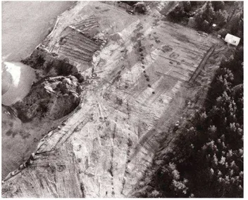
During extensive investigations including large areas of soil stripping in 1977, dark spots appeared in the sand close to the above mentioned features (Figure 5). The dark contour in the sand formed an oval feature and was interpreted as the foundation of a ship setting (Englund 1979:53). The feature measured c. 45 metres in length and was orientated WNW-ESE. Inside the feature two cremation burials were found. The graves included no artefacts and a relationship between these graves and the “ship setting” could not be verified. Outside the construction a pit containing charcoal and pottery surrounded by stones was found. A sample (St-7010) obtained for 14 C –analysis calibrated at two sigma gave the dating 1900-1450 BC (Figure 6).
Close to the “ship setting” a line of 15 oval features (c. 1,8 –1,2 m) interpreted as hearths were found. These were filled with fire cracked stones and contained a bottom layer which included large amounts of charcoal (Wickman 1978:97f). Two samples (St-6525, St-6526) were 14 C –analysed and, calibrated at two sigma, gave the date 400-900 BC (Figure 6).
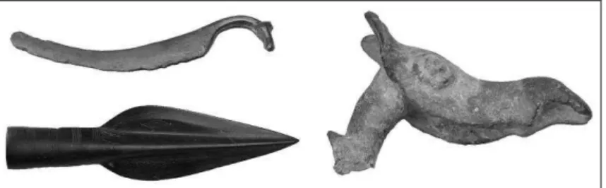
A settlement area was found in close vicinity to the earlier mentioned features. The area which covered 160 x 10-30 m contained pits, cooking pits, hearts and pieces of flint (RAÄ No. Vallstena 223:1). Indications of settlement and graves have also been found 200 m north-east of Vallstena 223:1. In a relatively large area, three stone settings and ten postholes were detected. These stone settings contained burnt bones, pottery and pieces of bronze (Vallstena 224:1). Furthermore, at Nygårds in Vallstena, a prominent razor with a horse-head handle has been found (Figure 7. Hansson 1927:25, Pl. 9). This type of bronze razor is quite common in the Nordic area (cg. Montelius 2002[1917] MM 927-930 and 1013-1015). Based on the curved shape, scholars have interpreted them as representations of ships (e.g. Glob 1969:55, Kaul 1998:93).
Figure 5. Aerial photo of the Uppgarde ship and the 15 hearths. Peter Manneke 1977
Communication and Meetings (Discussion)
The location of the Uppgarde Ship is interesting when adding the geological data. The Litorina transgression extending from the north fuses at this location with a small esker made up of glaciofluvial gravel. Both these geological formations have until present been used as landmarks and trails in the landscape. These two trails come together at a point which attaches to a former large inland lake connected to the sea via the Gothem River (Figure 3 and 4). This corresponds with the thinking that Bronze Age cairns lo-cated along the coast and placed high in the landscape were used for navigation (e.g. Hansson 1927:63, Stenberger 1945:58, Nylén 1959:9-10, Hallin 2002:21, Thedéen 2004:33pp). This visually connected the settled areas with the sailing routes and created an interconnected world of cosmological and political endurance (Kristiansen 2007:60). Johan Ling references the aforementioned in his discussion of the spatial connection between rock-art and old roads, which appear to end by the sea and “...form a pattern of movement” (2008:236).
I will now leave the discussion of barrows and cairns as territory makers (cg. Carlsson 1983:26-27, Bertilsson 1987:181) and expand the discussion by focusing on a communi-cating landscape or seascape. By doing so and raising the idea stressed by Hallin of possible meeting places around the Island (2002:77), referencing Karl Polanyis Ports of
Trade in Early societies (1963), new interpretations can be made. Might the significant Uppgarde Ship and its surrounding features indicate such a meeting place?
The Nygårdsrum and Uppgarde area stands out as exceptional through continuity that can be traced far back in time. The area may be discussed in terms of varied kinds of meetings, but if we want to hold a seascape discussion we must first move towards the coast where the sea meets land. According to Lise Nordenborg Myhre (2004), meeting places or “nodes” should be placed at strategic locations in the landscape. These places might have endings and beginnings, where the sea ends and the land starts for example. Such a node marks a liminal shift between different elements. Ling emphasizes the shore-zone as a “…dynamic boundary, a physical edge or ‘third space’ between three dominant spatial formations: sky, sea and land.” (2008:232). The shore-zone possibly created different kinds of social actions: for example arrival/departure ceremonies in
Figure 7. Some of the few Bronze artefacts found in the area. Starting up left clockwise: Razor: SHM 5604:51, Head (Horse/Moose): SHM 18814 and Spearhead (with fish orna-mentation): SHM 15192:2.
combination with transitional rites, meetings etc. Kurt Helskog (1999) extends the dis-cussion concerning the meeting of three dimensions to include the cosmological world and a meeting place for the spirits of these dimensions. Helskog emphasizes ideas about certain structural similarities between the cosmological and the physical world of people (1999:81).
Kerstin Cassel recently raises interesting ideas concerning meeting places and continues the earlier mentioned discussion of their location in places related to inland routes (Cas-sel 2008:84pp). According to the earlier discussion of the “case study” area as a possible inland route, the Gothem River-mouth could be such a place. When examining this area, an interesting feature appears south of the river-mouth referred to as the
Gothemsham-mar Stone Wall (RAÄ No. Gothem 131:1, see Figure 4). The wall is an exceptional
feature, which fences off a former peninsula and meets the visitor approaching by sea from the south. The wall is almost 500 m long, measures 4-8 m in width, and is orien-tated in a north-south direction. Today the wall ends at about the 12 m.a.s.l. elevation, which corresponds with the earlier suggested Bronze Age coast-line for this area. For a more concluding discussion of the Gothemshammar Stone Wall see Paul Wallin in this publication.
If we interpret the Gothemshammar enclosed area fenced inland by the wall and other-wise surrounded by the sea, it covers an area of c. 30 hectare. This is quite a large area and does not contain any further prehistoric remains or reported finds. The wall has been interpreted as some kind of defence construction, mostly due to the similarities with the Iron Age hill-fortifications on the Island (e.g. Manneke 1983, Olausson 1995). If the wall is to be interpreted as a defence structure, I find it difficult to understand its location or which side the purpose was to protect. According to the excavation profile drawing of the wall from 2009 it appears that the interpreted plank was situated on its east side (Wallin, nd.). There may have been a smaller platform on the other (west) side of the plank. West of, and on the inland side of the wall, there is also a row of shallow ditches. The sea side area of the wall consists mostly of inhospitable limestone shore gravel and was most probably during the Bronze Age an infertile and exposed place.
If we instead consider a maritime perspective, the location is a perfect navigational spot and landing place. Cassel argues that meeting places should be located in unique areas in the landscape, in particular if a large group of people arrives (Cassel 2008: 84pp). Addi-tionally, meetings would have required many forms of rituals (Helms 1988:25). This is of importance when considering the possible different backgrounds of the visiting people (Vikstrand 2001:234). They encountered a totally new world, other norms and values, a world filled with stories, myths and traditions, some which may have been more or less familiar. The latter were most probably connected to seafaring, coast life, foreign people, and places. As Chapman and Gearey suggest (2004), a more ritualised view of seafaring is needed. To be at sea has in many cultures been viewed as a deeply ritualised activity bound to traditions and superstitions. Rituals associated with maritime travel can be
traced both to physical and conceptual places (Ibid:455). To disembark at shore or in harbour today as well as in prehistory, accurate navigation is one of the main skills needed. As soon as land is visible one will need a pilot; a navigation technique which Needham (1971) refers to as “non-instrumental,” the accurate one when discussing the Bronze Age. Chapman and Gearey (2004:456) suggest that the barrows at the Kilnsea boat plank Bronze Age site may have served to help and welcome seamen, both in a practical and spiritual sense, as markers in the transition zone between sea and the estu-ary. From this point of view, Gothemshammar could be interpreted as a kind of “transi-tion zone”, a liminal space between the island society/societies and the visitors. The wall then becomes a kind of ritual border which in some way protected both sides. It is of great interest that the initial 14C dates from the recent excavations gave a somewhat un-expected age to around 1000 BC. (See Wallin in this publication for details).
Discussion of Boundaries and Movement
I will now leave the Gothem River-mouth and move inland along the proposed water route to expand the discussion of the significance of borders/boundaries and movement. Lines and paths may, as Nordenborg Myhre expresses (2004:32-33), be seen as channels of movement; coast-lines, rivers, valleys etc. Movement is an important factor when understanding space and the cognition of landscapes. How we move towards something involves our visual perception (Ibid:32). The significance of rivers, even relatively small ones, as “lines” or “paths”, is discussed by Marianne Lönn (1999) in relation to place names in Bohuslän. According to Lönn, names of rivers might be older than settlements. It seems the oldest villages were named after the river, but this changed during medieval times when the settled areas named the rivers. As Lönn (1999:146-147) mentions, this could demonstrate the significance of relationships to rivers in earlier times. Rivers could be discussed in terms of landmarks and bases for orientation in the landscape. This is interesting in association to my “case study” area where the Gothem- and Hörsne rivers definitely marks a border, or a path in relation to this landscape. Almost all ship settings and cairns appear, as mentioned earlier, north of the former lake and river. This pattern may be associated with eschatological ideas and the journey to the “underworld” or the “other side”. This is a kind of transition process, which according to Artelius (1996:10-11) could be applied in all Bronze Age graves where the ship symbol appears. Christopher Tilley discusses the crossing of the river using another approach related to the complex rock-art panels at Brådön, “…a boundary which must be crossed between the world of the profane and the world of the sacred” (1991:138). A similar interpreta-tion concerning the landscape has been discussed by van den Noort (2004) related to sites where two Bronze Age boats have been found in the Humber estuary, England (North Ferriby and Kilnsea). Van den Noort uses an ideological concept arguing that the two different areas of the landscape represents two different parts of social activity, one ritualized and the other non-ritualized. In his paper Van de Noort discusses seafaring as
a ritualized activity, a “rite of passage” and the sea as a liminal space near the monumen-tal landscape in Kilnsea. In North Ferriby on the other hand, the landscape appears to-tally different without any visible ritual features. He therefore interprets this site as a boat-building and repairing place belonging to the daily life. In an answer to Van de Noorts paper, Chapman and Gearey (2004) re-consider this view and argue for a broader consideration of boat-building and seafaring. They place the two sites in-between ritual and practical behaviour reflecting a kind of symbiotic relationship, the boatbuilding of North Ferriby at one stage and the monumental landscape of Kilnsea at another. The latter served both a practical and ritual function using the landscape during navigation and in rituals like arriving/departure ceremonies.
If we apply this discussion to the “case study” area, the complexity of dividing ritualized and non-ritualized space becomes clear. The north side of the Hörsne and Gothem rivers holds all visual remains, such as cairns and ship settings; remains often associated with the sacred world. Adding the geological conditions, the south and “ship setting free” side of the river consists mostly of rocky limestone ground. In contrast, the north side con-sists of moraine marl suitable for agriculture. On the north side there are indications of settlements actually having been found. The northern side of the former inland lake also slopes towards the sun which places the southern infertile side of the river in the shade. Thus, the north side of the river held both graves and fertile soils and was therefore most probably the place of everyday life. How then do we interpret the south side which actu-ally holds one important feature: The Gothemshammar wall? Might the south side be interpreted as the area of the foreign/unfamiliar/dread?
If we instead consider the earlier mentioned relationship between rock-art and ship set-tings on Gotland emphasized by Hansson (1927:86), interesting ideas can be raised. The term “landmark” is prominent in Nordenborg Myhre’s discussion, and is used as a refer-ence while navigating the landscape along with monuments and seamarks, including mobile features such as the sun (2004:32pp). Nordenborg Myhre categorizes certain rock-art sites as such landmarks, which Ling develops further by demonstrating that rock-art panels are located in close connection to the shoreline, lakes, and waterways. Moreover Ling demonstrates that the Bronze Age grave monuments are the prehistoric remains with the closest spatial relation to the rock-art (2008:154).
If we consider the Gotlandic ship settings not only as graves but also as landmarks in the landscape, it is possible to see them in alternate ways and understand why there is such a large variety of ship settings. The differences among the Scandinavian Bronze Age stone ships have been discussed by Rausing (1984) and Capelle (1995) and include the distinguished smaller boats used for travel over short distances and larger “warships” which were suited for long voyages. These differences are clearly visible in the Got-landic material where the smaller ship settings measure a few metres and the more prominent ones reach 45 metres in length. The largest ship setting existing today is
lo-cated at Ansarve, Tofta parish c. 20 kilometres south of Visby (RAÄ No. Tofta 14:1) and it has almost exactly the same proportions as the Uppgarde Ship. If the smaller boats were used for short journeys along the coast (or inland), the larger vessels might have been used for travel to the mainland. With that in mind, the significance of the Uppgarde
Ship and its surroundings, for example the long line of hearths found in its close
prox-imity, become interesting. In a recent study we (Bradley, Skoglund and Wehlin 2010) have raised the idea of making a possible comparison between the largest ship settings on Gotland and the mainland cult houses (which not have been found on the Island). Both features occupy similar positions close to the water’s edge and both form an open enclosure (Victor 2002). Furthermore, it appears that the cult houses played a specialised role in ceremonial matters, which may also be indicated in the Gotlandic ship by the above mentioned hearths and features in close connection to the commemoration of the dead. As mentioned, several of the smaller ship settings are associated with cremation burials.
By adding a maritime perspective and considering the Uppgarde Ship area a meeting place it could be interpreted as an arena for a large variety of rituals. Rituals may have for example been carried out in association with arrivals and departures of visitors/or voyagers before and after an overseas journey. The ship settings may therefore be struc-tures representing different “rites of passage” related to two very different journeys, actually leaving or arriving from a dangerous overseas journey or leaving for the “other side” and “arrival” at birth. The latter may have required certain rituals to connect the new born with a certain piece of land by burying the navel cord/placenta at the ship set-ting (e.g. Handy 1927:214-215). This may explain the “empty” ship setset-tings mentioned above. One should also consider the fact that seafaring can be dangerous and the arrival or rather the “non-arriving” after an overseas journey may therefore have been associ-ated with death. Many are the “empty” monuments of seafarers lost at sea in historical and modern times.
Conclusion
By taking a maritime perspective when studying a local site such as the Gothem River and the Lina bog area, new questions can be raised considering possible maritime institu-tions in the Baltic Sea area during the Bronze Age. With such a perspective the large variety of ship settings could be discussed in broader terms than merely chronology and change over time. It is tempting to relate the appearance of ship settings, a new phe-nomenon in the landscape, with the increasing amount of bronze artefacts at the time. Erik Nylén’s (1959) suggestion of “two cultures” may be to draw far-reaching conclu-sions, but a supposed maritime phalanx in the Bronze Age society could still be dis-cussed. People enrolled in a maritime institution; boat builders (recently acknowledged by Mary Helms (2009) as “The master(y) of hard materials”), seafarers, people with knowledge and skills required for overseas journeys, such as navigation etc., might have had a special place in the society. If so, they may be connected to the ship setting
tradi-tion and the feature could be seen as a primary instrument for collective identificatradi-tion, as in the rock-carving sites in Bohuslän. The burials become a secondary action in connec-tion with assembly places and a social arena for large numbers of rituals. Artelius (1999) stresses the idea that different types of graves may indicate ideological identity in the social structure and thereby mark regional identity. Furthermore, he argues that the crea-tion of the ideological landscape contributed to the maintenance of the social structure. I propose that the landscape/seascape in the “case study” area, with the exceptional fea-tures of the Uppgarde Ship and the Gothemshammar Stone Wall, could be interpreted in new ways. The fenced off peninsula of Gothemshammar could indicate a possible transi-tion-zone for local and foreign meetings of a more interregional kind. If the visitors, or some of them, later entranced the local world by moving along the supposed inland-route another regional meeting place can be distinguished at Uppgarde. Here, other rituals and ceremonies were performed and a meeting of the local traditions was more significant. It seems reasonable to suggest that lines or paths, how to move, articulate, and orientate in the landscape/seascape were important factors. The Gothemshammar Stone Wall, the line of hearths at Uppgarde and the Hörsne and Gothem rivers are all examples of clear boundaries visible in the landscape. A suggestion for further studies on the matters dis-cussed in this paper is the use of ethnological/ethnographical and historical accounts considering maritime life, which could possibly give indications of such actions and rituals useful to the discussion of the Bronze Age period in the Baltic Sea.
Finally, and relevant to the discussion of a maritime perspective, it is interesting that tradition claims that the grave of Tjelvar, the man who according to legend discovered and first brought fire to Gotland, is located on a cape just north of the “case study” area discussed in this paper!
ACKNOWLEDGMENTS
For financial support I’m grateful to De Badande Wännerna (Visby), Kungl. Gustav
Adolfs Akademien för svensk folkkultur (Uppsala), Nils Blomqvist, and The Baltic Rim Seminar (Gotland University).
References
Almgren, O. (1927) Hällristningar och kultbruk: bidrag till belysning av de nordiska bronsålders-ristningarnas innebörd. Stockholm.
Artelius T. (1994) ”Alla behöver en båt” In: Artelius, Tore, Hernek, Robert & Ängeby, Gisela (1994). Stenskepp och storhög: rituell tradition och social organisation speglad i skeppssättningar från bronsålder och storhögar från järnålder. 1. [uppl.] Kungsbacka: UV Väst, Byrån för arkeolo-giska undersökningar, Riksantikvarieämbetet. pp. 43-54.
Artelius, T. (1996) Långfärd och återkomst – skeppet i bronsålderns gravar, Riksantikvarieämbetet Arkeologiska Undersökningar- Skrifter No. 17, Göteborg.
Artelius, T. (1999) A Bronze Age perception of identity. Lund Archaeological Review 4, 1998. pp. 37-48.
Arwidsson, G. (1952) Husurnan från Ansarve i Tofta, Gotländskt Arkiv. pp. 16-37.
Ballard, C., Bradley, R., Nordenborg Myhre, L., Wilson, M. (2003) The Ship as Symbol in the Prehistory of Scandinavia and Southeast Asia, World Archaeology, Vol. 35, No. 3. pp. 385-403. Berntsson, A. (2005) Fiske och resor –ett nytt sätt att se på kommunikation, In: Nordiskt sympo-sium för bronsåldersforskning (2005) Mellan sten och järn: [rapport från det 9:e nordiska bron-sålderssymposiet, Göteborg 2003-10-09/12]. D. 1. Göteborg: [Institutionen för arkeologi, Göteborgs universitet] pp. 241-252.
Bertilsson, U. (1987) The rock carvings of northern Bohuslän: spatial structures and social sym-bols. Diss. Stockholm : Univ.
Bradley, R., Skoglund, P. and Wehlin, J. (2010) Imaginary vessels in the late Bronze Age of Got-land and south Scandinavia: Ship settings, rock carvings and decorated metalwork. Current Swed-ish Archaeology.
Broström, S-G. (1999) Hällristning på Fårö. Rapport över dokumentation av hällristning RAÄ nr 379 i Fårö s:n på Gotland, BOTARK.
Burenhult, G. (ed.) (1999) Arkeologi i Norden 1 & 2, Natur & Kultur, Stockholm. Capelle, T. (1986) Shiffssetzungen, Praehistorische Zeitschrift 61, Heft 1.
Capelle, T. (1995) Bronze Age stone ships: In Crumlin-Pedersen, O. and Thye , B.M. (Eds.) (1995) The Ship as Symbol in Prehistoric and Medieval Scandinavia. Copenhagen. pp. 71-75. Carlsson, D. (1983) Bronsåldern –tiden för kulturlandskapets territoriella framväxt och etablering på Gotland, In: Nordiskt symposium för bronsåldersforskning (1983). Struktur och förändring i bronsålderns samhälle: rapport från det Tredje nordiska symposiet för bronsåldersforskning i Lund 23-25 april 1982. Lund: Lunds univ:s historiska mus. pp. 23-36.
Cassel, K. (2008) Det gemensamma rummet: migrationer, myter och möten. Huddinge: Institu-tionen för kultur och kommunikation, Södertörns högskola.
Chapman, Henry P. and Gearey, Benjamin R. (2004) The social context of seafaring in the Bronze Age revisited, World Archaeology, Vol. 36, No. 4. pp. 452-458.
Clark, Peter (ed.) (2004). The Dover Bronze Age boat in context: society and water transport in prehistoric Europe. Oxford: Oxbow.
Clark, P. (red.) (2009) Bronze Age connections: cultural contact in prehistoric Europe. Oxford: Oxbow Books.
Coles, J. M. (2005) Shadows of a northern past: Rock carvings of Bohuslän and Østfold. Oxford: Oxbow Books.
Earle, T. K. (1997) How chiefs come to power: the political economy in prehistory. Stanford, Calif.: Stanford University Press.
Englund, S. (1979) Uppgarde i Vallstena, In: Falck, Waldemar (ed.) (1979). Arkeologi på Gotland. Visby: Press. pp. 53.
Farr, H. (2006) Seafaring as social action, Journal of Maritime Archaeology, 2006:1. pp. 85-89. Glob, P. V. (1969) Helleristninger i Danmark, Jysk Arkeologisk Selskabs Skrifter 7, Copenhagen. Goldhahn, J. (1999) Rock art and the materialisation of a cosmology –the case of the Sagaholm barrow, In: Goldhahn, J. (ed) (1999) Rock art as social representation, BAR International Series 794, Oxford. pp. 76-100.
Goldhahn, J. (2006) Hällbildsstudier i norra Europa: trender och tradition under det nya millenniet. Göteborg: Institutionen för arkeologi, Göteborgs universitet.
Hallin, G. (2002) Kummel, skepp och koksten – en studie om bosättningsområden och social struktur under bronsåldern på Gotland, Solna.
Hallström, A. (1971) Boplats och gravar på Nygårdsrum i Vallstena, Gotländskt Arkiv, Visby. Pp. 114-115.
Handy, E. S. C. (1927) Polynesian religion. Bernice P. Bishop Museum Bulletin 34. Honolulu. Hansson, H. (1927) Gotlands bronsålder, Kungl. Vitterhets Historie och Antikvitets Akademien, Del 31:1, Stockholm.
Helms, M. W. (1988) Ulysses' sail: an ethnographic odyssey of power, knowledge, and geographi-cal distance. Princeton, N.J.: Princeton University Press.
Helms, M. W. (2009) The master(y) of hard materials: Thoughts on technology, materiality, and ideology occasioned by the Dover boat, In: Clark, P. (ed.) (2009). Bronze Age connections: cul-tural contact in prehistoric Europe. Oxford: Oxbow Books. pp. 149-158.
Helskog, K. (1999) The shore connection: cognitive landscape and communication with rock carvings in Northernmost Europe, Norwegian Archaeological Review, Vol.32. No.2. pp. 73-94. Hernek, R. (1994) Skeppsformiga graver från äldre bronsåldern – utbredning, form och utveckling, In: Artelius, T. Hernek, R. and Ängeby, G. (1994). Stenskepp och storhög: rituell tradition och social organisation speglad i skeppssättningar från bronsålder och storhögar från järnålder. 1. [uppl.] Kungsbacka: UV Väst, Byrån för arkeologiska undersökningar, Riksantikvarieämbetet. pp. 19-25.
Kaul, F. (1998) Ships on Bronzes: A study in Bronze Age religion and iconography, Copenhagen, National Museum.
Kaul, F. (2004) Bronzealderens religion, Nordiske Fortidsminder Serie B 22, København. Kristiansen, K. (1987) Centre and periphery in Bronze Age Scandinavia. In: Centre and Periphery in the Ancient World, Rowlands, M., Larsen, M. and Kristiansen, K. (eds), Cambridge, Cambridge University Press. pp. 74-95.
Kristiansen, K. (2007) The Rules of the Game. Decentralised Complexity and Power Structures, In: Kohring, S. and Wynne-Jones, S., Socialising complexity: approaches to power and interaction in the archaeological record, Oxbow books. pp. 60-705.
Kristiansen, K. and Larsson, T. B. (2005) The Rise of Bronze Age Society. Travels, Transmissions and Transformations. Cambridge. Cambridge University Press.
Kvalø, F. (2007) Oversjøiske reiser fra Sørvest-Norge til Nordvest-Jylland i eldre bronsealder –en drøfting om maritim realisering og rituell mobilisering, In: Kvalø, F. and Bukkemoen, G. B. (2007). Sjøreiser og stedsidentitet: Jæren/Lista i bronsealder og eldre jernalder.
Larsson, T. B. (1994) Skeppet under bronsåldern. Funderingar kring relationen mellan praktik och symbolik, In: Selinge, Klas-Göran, Jensen, Ronnie & Bertilsson, Ulf (red.) (1994). Odlings-landskap och fångstmark: en vänbok till Klas-Göran Selinge. Stockholm: Fornminnesavd., Riksan-tikvarieämbetet. pp. 221-227.
Ling, J. (2008) Elevated Rock Art –towards a maritime understanding of rock art in northern Bohuslän, Sweden, GOTARC Serie B, Gothenburg Archaeological Thesis 49, Intellecta Solna. Lönn, M. (1999) Fragment av samtal: tvärvetenskap med arkeologi och ortnamnsforskning i bo-huslänska exempel. Diss. Umeå : Univ.
Malmer, M. P. (1981) A Chorological Study of North European Rock Art, Antikvariska Serien 32, Stockholm.
Manneke, P. (1983) Gotlands fornborgar, In: Jansson, I. (ed.) (1983) Gutar och vikingar: [gårdarna, borgarna ...]. Stockholm: Statens historiska mus.
Martinsson-Wallin, H and Wehlin, J. 2010. Rapport från arkeologisk undersökning i Uggardero-jrområdet 2009. Gotland University.
Meyer, J. (1646) re-worked by Örback, A. (1984). "Carta von Gottlant anno: 1646". [Gävle] b [Statens lantmäteriverk]. Digital from Almedalsbiblioteket, Visby, Gotlandica.
http://kain.hgo.se/Bibliotek/gotlandica/kartor/gotland/charta1646.pdf
McGrail, S. (2001) Boats of the World –from the Stone Age to Medieval times, Oxford University Press.
Montelius, O. (2002[1917]) Minnen från vår forntid. Faks.-tr. Gamleby: Arkeo-förl. Muckleroy, K. W. (1978) Maritime Archaeology, Cambridge. Cambridge University Press. Needham, J. (1971) Science and civilization in China, Cambridge.
Nordenborg Myhre, L. (2004) Trialectic archaeology: monuments and space in southwest Norway 1700-500 BC. Stavanger: Arkeologisk museum.
Nihlén, J. (1928). Sagornas ö. Sägner och sagor från Gotland. Natur och kultur. Stockholm. Nylén, E. (1958) Gotländska gravformer och deras betydelse för kronologien, TOR. pp. 64-86. Nylén, E. (1959) Gotlands murade rösen och bronsålderns fjärrhandel, Gotländskt Arkiv. pp. 9-34.
Nylén, E. (1972) Mellan brons- och järnålder: ett rikt gravfynd och dess datering med konven-tionell metod och C14. Stockholm: Almqvist & Wiksell.
Ohlmarks, Å. (1963) Hällristningarnas gudar: en sammanställning och ett förklaringsförsök. Stockholm: Tiden.
Ohlsson, A. (1984) Minnesbilder från en myr, In: Gutabygd: årsskrift för den gotländska hem-bygdsrörelsen. (1984). Visby: Gotlands hembygdsförbund. pp. 30-46.
Olausson, M. (1995) Det inneslutna rummet: om kultiska hägnader, fornborgar och befästa gårdar i Uppland från 1300 f Kr till Kristi födelse. Diss. Stockholm : Univ.
Pettersson, A-M. (1982) Skeppssättningar i Rute, En undersökning av sex gravar från den yngre bronsåldern, RAGU:s skriftserie 1982:2, Visby.
Polanyi, K. (1963) Ports of Trade in Early Societies The Journal of Economic History 23. pp. 30-45.
Randsborg, K. (1993) Kivik. Archaeology & Iconography, Acta Archaeologica 64 (1), Munks-gaard.
Rausing, G. (1984) Prehistoric boats and ships of northwestern Europe: some reflections. Malmö: LiberFörlag/Gleerup.
Rieck, F. (1995) Ships and Boats in the Bog Finds of Scandinavia, In: Crumlin-Pedersen, O. and Munch Thye, B. (eds) (1995) The Ship as Symbol, in Prehistoric and Medieval Scandinavian, Publications from the National Museum Studies in Archaeology & History Vol.1, Copenhagen. pp. 125-129.
Robb, J. E., and Farr, R. H. (2005) Substances in motion: Neolithic Mediterranean “trade”, In: Blake and Knapp (eds), The Archaeology of Mediterranean Prehistory 1, Oxford. pp. 24–46. Rönnby, J. (ed) (2003) By the Water. Archaeological Perspectives on Human Strategies around the Baltic Sea, Södertörn Academic Studies 17, Södertörns högskola.
Rönnby, J. (2007) Maritime Durées: Long-Term Structures in a coastal Landscape, Journal of Maritime Archaeology, No. 2:2007. pp. 65-82.
Sabatini, S. (2007) House urns: study of a late Bronze Age trans-cultural phenomenon. Diss. Göteborg : Göteborgs universitet, 2007.
Sardén Johansson, E. (2009) Att Synliggöra det Osynliga -GIS som verktyg i sökandet efter bosättningsområden från bronsåldern på Gotland, Kandidatuppsats i arkeologi. Högskolan på Gotland 2009.
Sernander, R. (1939) Lina myr. Stockholm:
Skaarup, J. (1995) Stone-Age Burials in boats, In: Crumlin-Pedersen, O. and Munch Thye, B. (eds) (1995) The Ship as Symbol, in Prehistoric and Medieval Scandinavian, Publications from the National Museum Studies in Archaeology & History Vol.1, Copenhagen. pp.51-58.
Skoglund, P. (2008) Stone ships: continuity and change in Scandinavian prehistory, World Ar-chaeology, 40:3, Routledge. pp. 390-406.
Stenberger, M. (1945) Det forntida Gotland.
Sylvester, M. (2006) Haugvikbåten fra Sømna – en plankebygd båt fra yngre bronsealder eller førromersk jernalder. VIKING, NTNU. Vitenskapsmuseet, Trondheim. pp. 91-106.
Thedéen, S. (2004) Gränser i livet - gränser i landskapet: generationsrelationer och rituella prak-tiker i södermanländska bronsålderslandskap. Diss. Stockholm : Stockholms universitet, 2004. Tilley, C. (1991) Material culture and text: the art of ambiguity. London: Routledge.
Van de Noort, R. (2004) An ancient seascape: the social context of seafaring in the early Bronze Age, World Archaeology, Vol. 35, No. 3. pp. 404-415.
Victor, H. (2002) Med graven som granne. Om bronsålderns kulthus Uppsala.
Vikstrand, P. (2001) Gudarnas platser: förkristna sakrala ortnamn i Mälarlandskapen = The places of the gods : pre-Christian sacral place-names in central Sweden. Diss. Uppsala : Univ., 2001. Westerdahl, C. (1996) Människa, hav och land– det maritima kulturlandskapet,
http://www.abc.se/~m10354/publ/maritima.htm, 2008-02-26.
Westerdahl, C. (1998) The Maritime Cultural Landscape. On the concept of the traditional zones of transport geography, http://www.abc.se/~m10354/publ/cult-land.htm, 2008-07-23.
Westerdahl, C. (2005) Seal on Land, Elk at Sea: Notes on and Applications of the Ritual Land-scape at the Seaboard, The International Journal of Nautical Archaeology, (2005) 34.1. pp. 2-23. Wickman, G. (1978) Undersökningar i Vallstena, Gotländskt Arkiv, Visby. pp. 97-98.
Widholm, D. (ed.) (2007) Stone ships: the sea and the heavenly journey. [Kalmar: Institutionen för humaniora och samhällskunskap, Högskolan i Kalmar.
World Archaeology (2004), Seascapes, Vol. 35, No. 3. London: Routledge & Kegan Paul. Wranning, P. (2006) Lugnarohögen –en grav med dubbel historia. Hur en skeppssättning i hög från yngre bronsålder anlades, återupptäcktes och rekonstruerades, In: Utskrift 8 (2006), Halmstad: Uppdragsverksamheten, Stiftelsen Hallands länsmuseer. pp. 131-171.