Water balance evaluation and regularization of Albanian rivers
basins
Niko PANO1, Bardhyl AVDYLI1, Marenglen BUKLI2, Koco GJOKA2 1Albanian Academy of Sciences, Hydro meteorological Institute, Tirana, Albania
2Albanian Academy of Sciences, Institute of Informatics and Applied Mathematics, Tirana,
Albania
e- mail:bavdyli@icc-al.org; mbuk@inima.al; kgjo@inima.al
Abstract- Albanian river basin is one of the main and most complicated natural territories in Europe: mountainous regions of an average altitude of 785m above the sea level, particular littological structure with an important cal care formation, typical Mediterranean climate regime, etc. This basin is 43 305km2, where 28 500km2 is inside the Albanian state and the rest outside it (Greece, FYROM, Kosovo, Monte Negro). Albanian catchments area water discharges into Adriatic and Ionian Seas. In this paper it is attempted to present a general evaluation of the water balance in the Albanian river system, including regionalization of the catchment’s area of this system, according to the correspondent types of the water balance.
Key word: water balance components, potential and real evatranspiracion, global territory humidity, rationalization.
1. Introduction
Water balance evaluation and its rationalization is one of the main and most complicated problems because of the natural specific conditions of Albanian rivers basin (mountainous regions, particular litho logical structure with important cal care formation, the present of the important lake system, the Mediterranean typical climate regime etc.)
In Albania many particular studies were performed to evaluate different components of the water balance of the rivers basins (Pano 1984, 1985, 1993 and 1995; Mustaqi 1986; Saraçi 1989; Kazazi 1985, etc.). In this paper (from the existing partial studies) it is attempted to present a general evaluation of the water balance in the Albanian rivers system, including regionalization of its catchments area, according to the corresponded types of water balance.
In the Albanian hydrographical network there are 11 principal rivers together with their numerous branches such as Buna River with the
catchment’s area of the F= 5750 km2; Drini River F= 14137 km2; Vjosa River F= 6706 km2; Semani River F= 5640 km2 etc. There are 125 other rivers with a small catchment’s area F>50 km2.
2. Materials and methods
Water balance evaluation was based on the multi-annual archival data of the Albanian hydro meteorological institute of the Academy of the Sciences.
The monitoring network consists of more than 175 hydrometric stations for the evaluation of the river run-off for an observes period of 20-50 years; 160
pluviometer and pluviograph stations for evaluations of the precipitation for an observed period of 15-40 years and 9 experimental station type GGJ for the evaporation evaluation from the water surface for an observed period of 20-25 years. These stations are located all over the territory.
All the maps of the water-balance components and their principal hydrological parameters are compiled to the rational topographical maps of 1:750 000 scale. For the natural specific conditions of the Albanian rivers basin, particularly, for mountainous areas, values of both hydrological
elements were computed on basis of their vertical gradients and their altitudes above sea levels.
The methodology of the water balance components valuation used in the paper consist in:
- computation of annual precipitation with p=50% probability for the representative meteorological stations - xi, classification of the Albanian territory by gradients:PM = xi/zi and composition of geographical distribution map for annual precipitation; - Computation of annual run-off level y0,i for the representative
hydrometrical axes. These stations are divided in principal categories, depending on the hydrographical, hydrological and the hydraulically specific natural conditions.
1) Drini, Mati, Ishmi, Semani, Vjosa rivers, etc., where the run-off discharge – Qi is computed as a function Qi = f(Hi), where Hi is altitude of water level river section i.
2) Water system: Scutary Lake – Drini River – Buna River. This hydrographical complex with great catchment’s surface of about 20 000 km2, as is well known, is very complicated and unique for its hydraulic regime in the Mediterranean hydrograph. This particularity has made necessary the particular modeling for estimation of the water flow of Buna Rives. The discharge of the Buna River that flows away from the Scutary Lake – Q2, depends upon the lake level – H2, and the River discharge into the Buna River – Q4. The Buna discharge was calculated by the following equation (Pano 1973, 1984, 1994, 1997, 2003): ⎪⎭ ⎪ ⎬ ⎫ ⎪⎩ ⎪ ⎨ ⎧ − ⎥ ⎦ ⎤ ⎢ ⎣ ⎡ ⋅ − = 4 85 . 1 2 61413 . 1 2 2 2 2 2 ) 073 . 0 ( 025 . 0 Q H Q H Q
The Q2 = f(H2,Q4) values correspond to the results that have been obtained through the hydraulic calculations. The differences of the values of discharge – Q2, which have been calculated by both methods, are small, about δQ2 = ±3%.
3)
- Lake system: Micro Prespa – Macro Prespa – Ohri Lake the run-off discharge – Qi is computed by the water balance method, Qi = Wp/t, where Wp is the volume water annual, t- time in second.
- Computation of the annual river run-off level – y0 in the mm, y0 is computed by the formula: We/F, where F is the catchment’s area in
kemp. Albanian territory classification by gradient PAM = yes/h and composition of the geographical distribution map for y0, according to vales of gradients PM1 = y0/h.
- Computation of the Potential evotranspiration – Ep by the formula: Penman, Thorthasait, Ture, etc. for the representative meteorological stations, classification of the territory by gradients Ri = Ep/h and the composition of the geographical distribution map for Ep according to respective values of gradient – Ri.
- Computation of the real evotranspiration – ER for the representative meteorological stations and deficit of the flow – Z0 for the
representative hydrometric stations. The ER is computed by the formula: Turc, Contage, Thorthwait, and Konstandinos. The deficit of the flow - Z0, is calculated by: Z0 = (x0-y0) and is verified by GG Information. Albanian territory classification by gradient Pi = ER/h and the composition of the geographical distribution map for ER according to respective values of gradient Pi.
- Computation of the deficit of the evotranspiration – DE, DE is computed as the difference DE = (EP –ER)
- Computation of the deficit of the precipitation – Dx0, Dx0 is computed
as the difference Dx0 = (EP –x0)
- Computation main parameters of the river discharge for
representative hydrometric axes, such as: module of river run-off –
Q0 = Wp/t in ls/km2, run-off coefficient - α = y0/x0, evotranspiration coefficient – az = z0/x0, etc.
- Evaluation of the groundwater run-off discharge by determining the type of the water supply of the Albanian rivers system, respectively by: surface water discharge – QSi and groundwater run-off discharge – QN0, where (QN
i + QSi) = Q0,i. This evaluation is bases on
computation of the dynamic coefficient of the run-off discharge - η by Kudlinas method (Kudina B.J. 1966)
- Computation of the main parameters of the groundwater run-off discharge such as: module of groundwater run-off discharge – qN
0 =
WN0/t in l/s km2, the annual groundwater run-off level - yN0 = WN0/F in mm, annual groundwater run-off coefficient - αN
0 = yN0/x0 , groundwater run-off volume: W0N
= Q0t, global territory humidity -
µo = (xo-µos), where: yos is the annual level surface water and infiltration coefficient - βo = µo/xo
Evaluation of the water balance in the Albanian river system including regionalization of the catchment’s area of this system, according to the correspondent types of the water balance. One of the important representative integral indicators to estimate the water potential formation process in the rivers basin is the annual module run-off discharge – qo in l/s km2. The global humidity of the territory - µo in mm is also an important indicator.
3. Analyses of the results
This division scheme of the Albanian territory in homogeneous regions, based on evaluation and determination of the natural factors influencing the water balance process formation.
Analyzing and dividing the Albanian territory in homogeneous areas, region is accepted as the smallest tacsionometric unit.
Considering the physical-geographical conditions, the Albanian territory is heterogeneous, but homogeneous areas, having the same water balance nature and where the corresponding values of the elements of this water balance are the same, may else be determines.
Classification of the Albanian rivers basin is carried out for the following water balance types:
I- Type I, A1B1 – Low global territory humidity (module qo=10÷20 l/s
km2)
II- Type II, A2B2 – Mean global territory humidity (module qo=20÷40 l/s
km2)
III- Type III, A3B3 – High global territory humidity (module qo=40÷80 l/s
km2)
Regionalization of the Albanian river basin according the corresponded types of water balance is presented in Tab. 1.
The principal water balance components hydrological parameters are presented in the Tab. 2.
The annual precipitation on the Albanian rivers basin range from the 750 mm in the coast area to 4444 mm in mountain with a average all over the catchment’s area is xo=1544 mm.
The water potential of Albanian river system is Wo= 41,249*109 m3, that
corresponds to a discharge of Qo= 1304 m3/s, and a module of qo= 30.1 l/skm2.
So Albania is one of the countries of a high specific water potential in Europe. The run-off level – yo range from the 250-600 mm to 1250-2800 mm, with an
average all over catchment’s area yo=600-1250 mm.
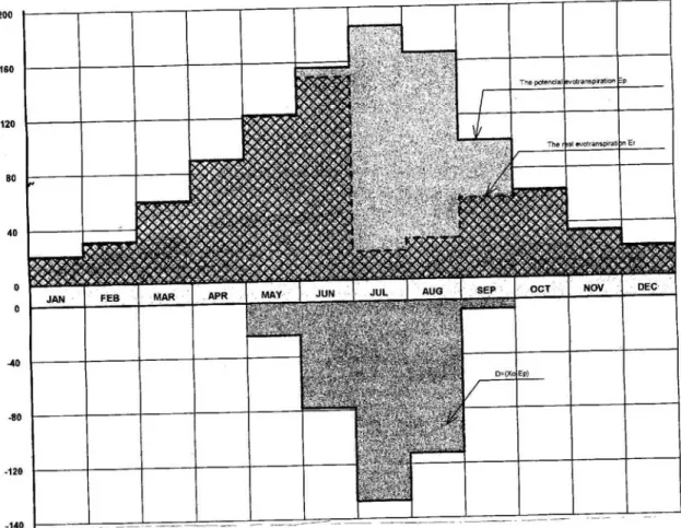
The Real Evotranspiration on the Albanian rivers basin range from 300 to 800 mm average all over the catchment’s area is ER=500-600 mm.
The annual distribution of Evotranspiration Potential – Ep, Real
Evotranspiration - Ep, Deficit Evotranspiration – DE and Deficit Pluviometric –
REGIONALIZATION OF THE ALBANIAN RIVERS BASIN ACCORDING TO THE CORRESPONDED TYPES OF WATER BALANCE
Tab. 1 Precipitation X (in mm) az<0.30 ---αo>0.45 az=0.30÷0.50 --- αo=0.45÷0.30 az>0.50 ---αo<0.30 1 2 3 4 >1750 IA1, B1 - - 1250 ÷ 1750 - IIA2, B2 - <1250 - - IIIA3,B3
PRINCIPAL ELEMENTS AND PARAMETERS OF THE WATER BALANCE Tab. 2 N° ELEMENTS UNIT REGION IA1, B1 IIA2, B2 IIIA3, B3 1 Xo mm < 1250 1250 – 1750 > 1750 2 Zo mm < 600 501 - 600 > 300 3 Yo mm < 600 600 – 1250 > 1250 4 ER mm < 500 500 – 600 > 600 5 ηo - < 0.55 0.55 – 0.75 > 0.75 6 αz - < 0.35 0.35 – 0.45 > 0.45 7 Dxo mm < 200 200 – 1000 > 1000 8 DE l/s.km2 < 250 250 – 400 > 400 9 qo mm < 0.25 0.25 – 0.35 > 0.35 10 Yos mm < 620 620 – 660 > 660 11 Uo mm < 750 750 – 1000 > 1000 12 yoN mm < 280 280 – 315 > 315 13 qos l/s.km2 < 18 18 – 22 > 22 14 qoN l/s.km2 < 7 7 – 12 > 12 15 ηoN - < 0.16 0.16 – 0.25 > 0.25 16 Ku % < 26 26 – 35 > 35 17 βo - < 0.21 0.21 – 0.35 > 0.35
4. References:
Kudeina BJ – Podzemni stok na territory SSSR. Izd.Mosk.Universitet 1966 Geografia na Blgarija (Fiziceskaja geografia), Bulgarskoje Akademia Naukite
G.Inst.Sofia 1982
Institute de Meteorologie si hidrologie. Bucuresti 1971 Shiller G Die Donau und ihr Einzugsgebiet
Eine hydrologische Monographie. Teil I, texte 1989 Munhen, Germany Pano N. 1974 – Sur les lais de penetration des eau Jonienne dans l’Adriatique
Inst.Hidrometeorology. Academy of Science, Tirana.
Pano N.and Avdyli B 1984 – Hydrology of Albania. Monography. Inst.Hidrometeorology (in Albania) Academy of Science, Tirana.
Pano N. 1994 – Dinamica del littoroli albanese (in Italian) Atti del 10 Congresso A.I.O.L. Genova. Italia.
Simeoni U. Pano and P.Ciavolle 1997 – The coastline of Albania. CIESM Science Series Nr.3
Frasheri A. and Pano N. 2003 – Impact of climate on Adriatic Sea hydrology. Elsevier ocesnography series – Amsterdam 2003.