~ ~ G~t.:Eit:Y l'l'!t
r
<1. u9( I ,
,
',
\ I,
o. ...
• ••• \flu~"" Bos111 '8~'1Co.., ..,i1 &o't
IAJOl~ Q.. ....
.f
,
'
w
,
WRIGHT WATER ENGINEERS
ENG IN EER I NG CONSU L TANTS
I 240 W ES T 84Y 4U D AV ENUE
DENV ER. CO LORADO . 8 0 2 2 3
MltM81tll
22
November1967
P H O NE
744 - ~
Hr. Hugh Burns, Attorney •t Law Dawson, Nagel, Sherman and Howard First National Bank Building
Denver , Colorado
80202
Dear Hr. Burns:
Re: Industrial Water Supply Middle South Platte Valley
We have made preliminary hydrologlc Investigations relative to providing an lndustrl•l development with a dependable year around w•ter supply as you have requested. The area reviewed Is In the middle South Platte Valley between Broom-field and Fort Coll Ins, and between the mountain foothills on the west and the
South Platte River on the east. '
The studies have been necessarily of a reconnaissance nature because of the conf ldentl•l character of the ...ork and the early stage of planning. Water
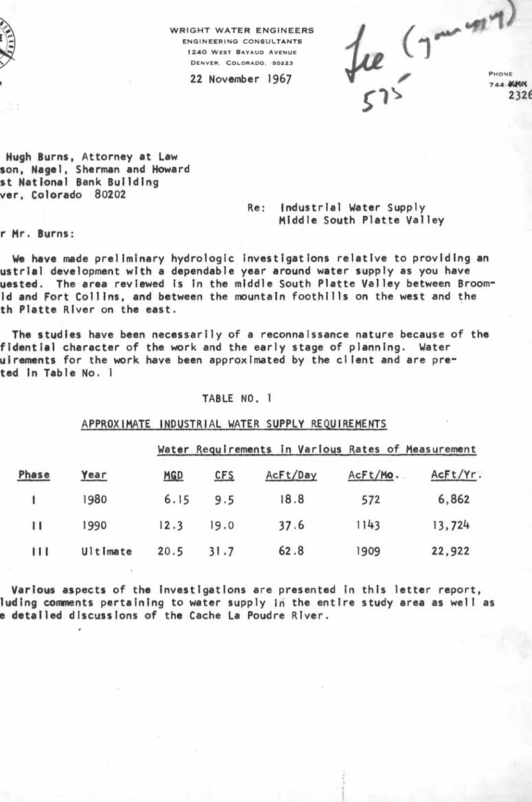
requirements for the ...ork have been approximated by the cl lent and are pre-sented In Table No. 1
TABLE NO.
APPROXIMATE INDUSTRIAL WATER SUPPLY REQUIREMENTS
Water Requirements In Various Rates of Measurement
Phase Year MGD
ill
AcFt/Day AcFt/Ho • . AcFt/vr·,1980
6.15
9,5
18.8
572
6,862
II
1990
12.3
19.0
37 .6
1143
13,724
111 Ultimate
20.5
31.7
62.8
1909
22,922
Various aspects of the Investigations are presented In this letter report, Including conwnents pertaining to water supply In the entire study area as wel I as more detailed discussions of the Cache La Poudre River.
Industrial Water Supply, 22 Nev~r:
19b7
GENERAL LOCAT jON OF PLANT SITE BASED UPON WATER SUPPLY POTENTIAL
Page ·2
I. We have generally reviewed the area from the foothills to the South Platte River and from the Broomfield area north to the line between Greeley and Fort Coll Ins. The potential natural water sources In this area consist of Cache la Poudre River, Big Thompson River, St. Vraln Creek, Left Hand Creek, Boulder Creek, Clear Creek, and South Platte River. In addition to these natural streams, other water supply considerations Include the Colorado-Big Thompson Project water, private trans-mountaln water projects from the western slope, reservoir storage, the Denver Water Board, and some miscellaneous and speculative type suppl les I i ke the Ell lot Project from the Steamboat Springs area.
2. Generally reviewing the supplies, we have the following comments:
a. c·lear Creek. This supply Is already heavily used, and It would be virtually impossible to develop a large dependable supply from this source. Prices for water are also high due to the high competition for the water by Denver suburbs.
b. Denver Water Board. Treated water is available from the Denver Water Board; however, the unit price of 38¢ per thousand gallons almost makes the use of
Denver treated water prohibitively expensive on an annual cost basis. Thi~
unit price amounts to approximately $124 per acre foot. Untreated water is sometimes available from Denver, though this Is doubtful for the southern portion of the study area. If untreated water was available from the City of Denver, the price at the present ti~e, which is not fixed for the future,
would be approximately $75 per acre foot. Water at this price for 10,000 acre feet per year would amount to $750,000 per year. Denver Water Board treated or .untreated water is not available north of Broomfield because of practical service area 1 imitations,
c, Boulder Creek. The flow of Boulder Creek is largely used for irrigation of farm land east of Boulder. However, the City of Boulder is presently In an
aggressive water right acquisition program to support a populatlo~ of
approxi-mately one-quarter of a mill ion people, Acquisition of large amounts of
water on Boulder Creek would run into stiff opposition by the City of Boulder, and costs would spiral in a short while, It ls . believed that a 10-15
second foot supply on Boulder Creek might be approximately the limit of the available supply there,
d, St. Vrain Creek and Left Hand Creek. These creeks can be generally thought of as one because water is diverted from St. Vrain Creek by the Left Hand Ditch Company, and the two streams join upstream of the confluence with the South Platte, Recent development work on the St. Vrain by the City of Longmont will tie up a substantial amount of the exchange potential for winter water in this basin, and at Longmont during the Irrigation season
the stream Is usually dry. However, below Longmont there Is a substantial amount of return flow coming back into the basin which does provide a
regular physical supply of water in the stream between Longmont and the South Platte River. Longmont is approximately 18 miles upstream from the confluence of the South Platte. In essence, It Is our opinion that
Industrial Water Supply, 22 Nov~mber 1967 Page 3
a supply of water between 20 and 50 cfs could be developed on the lower
reaches of the St. Vraln In conjunction with the South Platte. This general area Is getting close to the Publ le Service Company atomic power plant at Platteville. There Is no question that some confl let of water rights would be developed with the Public Service Company because they will be heavy users of water and do have early water rights.
e. Big Thompson River. The lower reaches of the Big Thompson River appear to
hold promise for a water supply ranging between ~O and 50 cfs, again when
coupled with backup water from the South Platte River. The flow in the Big Thompion In the lower reaches Is sustained, l Ike other eastern slope streams, by return flow from Irrigation. In dry years the flow in the stream averages generally over 50 cfs for June, July, and August. Records
indicate that In May and September the flow drops to very low levels because of the effect of the pattern of upstream Irrigation.
f. Cache la Poudre River. The Poudre is the South Platte River's largest tributary basin, which drains fairly good yielding country to the west of -Fort Coll Ins up to the Continental Divide. During the irrigation season the Poudre dries up at several spots because of diversions by irrigation . ditches, but this ls not because of lack of basic water; it Is due to high utilization of the water for Irrigation purposes. In addition to the natural flow of the stream, the Poudre has good trans-mountain diversion facilities developed by private companies. These diversions come from the
Laramie, the Michl gan, am(
the ..
Colorado Rivers- and approximate 35, 000 to40,000 acre feet per year. In a dry year the flow In the lower portion of the stream above the confluence with the South Platte gets quite low due to the heavy use of water throughout the lower length of the Poudre. However, It ls -known that substantial flow does re-enter the Poudre below Fort Collins. With substantial effort, It Is believed that one could
develop a sunmer supply from the Poudre ranging from between 20 to 50 cfs,
though this would not be an easy task.
g. South Platte River. The South Platte River has a good alluvium parallel Ing the s.urface stream, .which generally permits the development of high c11pactty
wells of perhaps 1,000 gpm each. In addition, there Is a good basic
physt-call supply In the South Platte River, but there Is no question that the stream goes dry at a number of points because of the heavy diversions by
trrlgators. Because of the large size of the river basin and the huge amount of Irrigated land along the South Platte River, It would appear that water rights could be acquired on the South Platte River, probably more easily than on any of the tributaries.
h. Colorado-Big Thompson Prolect. The area from Boulder to Fort Collins and Greeley Is Included In the Northern Colorado Conservancy District. Primary eastern slope reservoirs In the system are Carter lake and Horsetooth
Reservoir. Water Is available to shareholders during the Irrigation season,
generally from April 15 through October, upon demand based upon the number of
units owned. Water from the CBT Project Is charged losses when carried In private Irrigation ditches. The posslbll lty exists for negotiating with the Board of Directors for releases during the winter time. While this Is
Industrial Water Supply, 22 Noveiwber .
1967
Page4
somewhat out of _the ordinary, we bel !eve that there Is no reason why t~e
Board of Directors would not agree to this under the circumstances. This
1 opinion has been verified by the Manager of the District.
I. Private-Trans-Mountain Water, Trans-mountain water Is jealous·ly guarded by the irrigation companies who developed it, and It ls normally considered a part of the water owned by the Individual shareholders. There ls no question that to acquire water of this nature would be difficult and would be opposed
by the ditch dlrectas and stockholders. However, If shares are obtained
ln
a ditch having trans-mountain suppl les, legal mechanisms undoubtedly exist for obtaining this water though there are undoubtedly practical I Imitations which need to be considered. The Water Supply and Storage Company of Fort Coll Ins Is the prime Importer of water from the outside river basins Into the Poudre, not considering the CBT Project.
j , Miscellaneous and Speculative, These supplies may or may not be available, and plan61ng for the use of such supplies does not seem prudent at this time for a project which requires complete rel iablllty of water supply. Such sources are generally looked at for supplemental supply purposes after a basic supply has already been developed and ~an be counted upon.
3.
In reviewing the overall situation for the Industrial use water supply, one nextcenters his .attention on the general area In the triangle formed by Greeley, Longmont, and Fort Coll.Ins. For Instance, a supply appears to be developable on the lower
reaches of the St. Vrain, along the lower reaches of the Big Thompson, and along the lower reaches of the Cache la Poudre. Each of these areas must obtain Its year around water supply from several sources which would Include natural stream flow in
the streams themselves, diverted on the basis of direct flow water rights acquired In those streams. It would also Include the use of CBT Project water, and It would also include the supplementary use of the South Platte River, the water coming from surface water diversions and probably diversions using wel Is. Water rights would need to be acquired for South Platte River use, but these are considered to be
available, though the final location of any diversion point must be carefully chosen so as to create minimum adverse effects on other water users. In addition to those supplies mentioned, undoubtedly additional water would come from other sources sucb as river reservoir water and perhaps some private trans-mountain projects.
4.
Further narrowing down of the possibilities takes one to the Big Thompson Riverand the Poudre. One reason for this, that Is the el lmlnatlon of the St. Vraln, is that the possibility exists for fl'X)re direct and longer season releases from
Horsetooth and Carter Lake to the Big Thompson and the Poudre than appears to be the case for the St. Vraln. ij n essence, it Is believed that the appropriate supply could be most readily developed either on the lower reaches of the Poudre or on the lower reaches of the Big. Thompson.
5.
Going one step further, advantages accrue to the Cache la Poudre River becauseIt is the Poudre which has the private trans-mountain diversion projects rather than the Big Thompson, and we are of the opinion that the Fort Coll Ins water board, the Greeley water board, and Poudre private ditch companies would be more accomodating
In the helping out of a new Industry than would the City of Loveland. An additional -point which tends to make the Poudre the first choice ls that the Bureau of Reclamation
Industrial Water Supply,
22
Nov•mber 1967 Page 5 has done significant studies In the Poudre Basin on water development for munttlpalIndustrial, and agricultural purposes, and while this ptoject :-wH1 :.not be built for many years In the future, we are of the opinion that such a project will go to fruition within 15 to 30 years. This project has the key feature of tdlewlld Reser-voir, with a potentfal · stotage capacity of about 180,000 acre feet.
6.
After choosing the Poudre as a stream having the most advantages fordevelop-ment of a large Industrial supply, the Windsor area appears to be most promising. Furthermore, the Great Western Sugar Company has land and water rights for sale at Windsor. Two ditches having senior water rights irrigate land at Windsor. The
ditches are the Whitney and the B. H. Eaton with water right · decrees for significant rates of flow:
Windsor ls about half way between Horsetooth Reservoir and the South Platte River. The land which Is for sale straddles the Poudre, making river flow physically avail-able without using private Irrigation artches. This ls advantageous for use of CBT water.
The proximity of the Great Western farms to Windsor Lake with 1200 acre feet of capacity is an advantage because terminal raw water storage Is often useful in providing carry-over Industrial water from one month to the next. While the Great Western farms are not the only lands In the area suitable for use, it Is our opinion
that any property acquisition Include water rights In the two ditches mentioned above, that Is, the Whitney and the B. H. Eaton. For additional studies, we have chosen the Great Western land and water rights as an example which ls described in the next section of this report.
WATER SUPPLY POTENTIAL
In western water supply work It ls often thought best not to "put all of one's eggs In one water supply basket." A review of the factors surrounding the develop-ment of an initial supply of 575 acre feet per month, and an ultimate supply of 1910 acre feet per month on a firm basis makes this concept both wise and necessary. It
Is wise because it provides a degree of Insurance against unforeseen emergencies such as widespread power outages and drouth effects. It Is necessary If the new Industry
ls not going to create an Impact and adverse effect upon existing water users. Water requirements and water supply for each month of a typical dry year are shown In Table Nos. 2, 3, and 4 for Phases I, I I, and Ill, respectively. The tables are presented for II lustratlve purposes only, and do not reflect an actual antici-pated operational plan . Such operational plans must await further economic studies, qua I lty requirements, and treatment and pumping analyses so that the most economical
combination of sources may be u~ey a~ a~y given time. ,
! •
I
Indust ri a l Water Supply, 22 November 1967 P~e 6
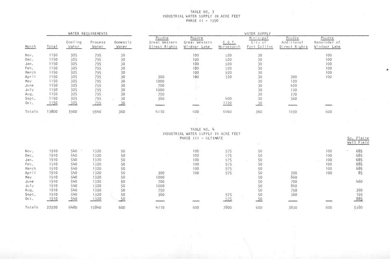
The reader will note that Phase i water supply Is a combination of the existing
Great Western water rights, Col&rado~Btg Thompson Project units, and domestic water
from Fort Coll Ins. It Is our opinion that ~11 water rights for Phase I are presently
for sale and could be acquired Immediately. The City of Fort Collins has Indicated to the writer that It ls ready and will Ing to sell water outside of the City boun-daries to potential Industrial users.
Phase ~I water supply Is the same as Phase I, except that all sources have been
doubled. The additional direct flow rights from the Poudre are assumed to be from
land adjacent to the Great Western fac~s. and from baslcal ly the same ditches. The
remainder of the Windsor Lake is shown as being acquired. If the Lake was not available, other reservoir water of a similar nature would be suitable. The nwnber of CBT units Indicated In Table No. 3 Is 8300.
Table No. 4, which shows the water supply for the ultimate development, Includes
an additional source of water from the South Platte River. CBT Project units have been Increased to 10,000 for this Phase I II.
Ultimate development supplies, as shown in Table No. 4, are made up of f Ive categories of water In the amounts as Indicated below.
Poudre Direct Flow Poudre Storage
CBT--Horsetooth Reservoir South Platte River
City of Fort Collins
7, 940 Ac. Ft. l, 200 Ac. Ft. 7,800 Ac. Ft. 5,380 Ac. Ft. 600 Ac. Ft. 34.6%
5.2%
34.1% 23.5%2.6%
It Is our opinion that additional water would be available for development of
an Industry having requirements In excess of that shown In Table No.
4.
In regard to acquisition of the water rights and the timing of the acquisition program, It should be pointed out that the entire package could be purchased
Initially without fear of abandonment because of non-use. It Is our opinion that water right costs will rise faster In the future than the corrblned offsetting effect of Interest on the Investment and normal Inflation. However, acquisition of most of the program could be put off for a number of years though all ·the needed direct flow rights on the Poudre should be :acquired initially because of the desirability of the Whitney Ditch and the B. H. Eaton Ditch rights. Announcement of a major Industry
in the area could make rights In these two early ditches very difficult to purchase on a reasonable basis.
WATER QUALITY
The qual tti of water Is an lmportan~ consideration In any water supply work,
The qua! lty of water Is controlled to a ~arge extent by return flow from upstream
users. Such users include industry, municipal lties, and lrrlgators. The effect of these users ls amply represented in the chemical analyses of water supplies with
increased chlorides, nitrates and total dissolved sol ids.
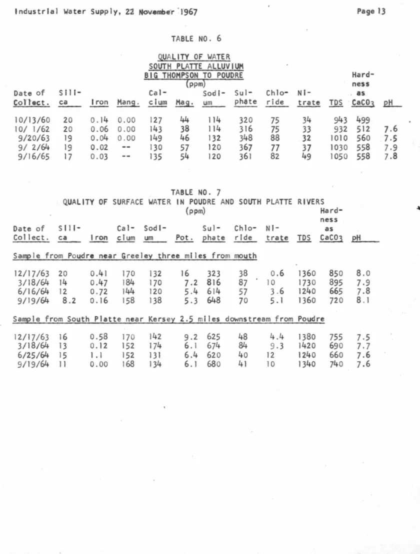
Table No. 6 presents results of chemical tests of water from the South Platte alluvium In the vicinity of a potential well field for the subject Industrial supply.
In general, the ground water qua! ity Is fa .lrly stable, not being changed by day to day fluctuations In the qua! lty of the surface water. Wells with 60 feet of satu-rated depth may be planned for.
Industrial Water Supply, 22 November 1967 Page
7
Analyses of surface samples from the Cache La Poudre River near Greeley, together with the South Platte River near Kersey, are given In Table No. ]. The Poudresamples are not representative of the quality of the river at the headgate of the B. H. Eaton or Whitney Ditches because of substantial return flow downstream of Windsor. Qual lty tests have not been made in the Windsor area.
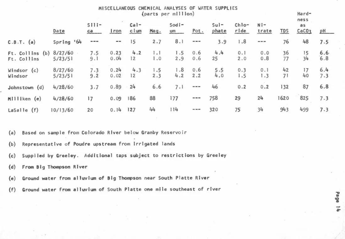
Table No. 8 presents analyses of samples from the Fort Collins system,
Horse-tooth Reservoir, and the Windsor water system. The quality of the Poudre at the canyon mouth, and the qua I ity of Horsetooth Reservoir water Is generally considered to be of outstanding purity.
Numerous additional tests are on file In our office which are available for Inspection.
Detailed and general discussions of water quality are given In reports pub-1 ished by the Federal Water Pollution Control Administration which are also avail-able in our files.
COSTS
Costs for water rights at this time are somewhat nebulous because of the early stage of the investigations. However, an indication of the magnitude of capital expenditures Is presented below. Physical facll ltles such as plpel Ines and pumping
plants to util lz~ the water would be In addition to the figures shown. '
The estimated cost of 3,75 mill Ion dollars for the total Phase I II water right acquisition represents a unit cost of $0.03 per thousand gal Ions.
The capital cost of the water rights Is expected to be $264 per gpm for the Phase Ill development, and at $324 per gpm for Phase I.
Nominal annual costs are associated with ditch company direct flow right owner-ship for operatlQn and maintenance. CBT Project water units are assessed an annual charge set by the Board of Directors, the charge at the present time for municipal and industrial water being about $5.00 per unit per year.
Table No.
5
presents a tabulation of estimated water right acquisition costsfor each phase, coupled with unit costs of the capital Investment computed at
6
percent, and expressed In cents per l,000 gallons. The capital costs of waterrights expressed as dollars per gpm of continuous flow are also given In Table No. 5. The cost of physical facll I ties to deliver raw water to the plant site varies within wide l lmlts, depending upon the category of water being considered. For in-stance, water from the B. H. Eaton and Whitney Ditches would be de! lvered, for all practical purposes, without any further new construction. CBT water can be de! ivered much of the year by using the river as a carrier. Only diversion facilities would be needed.
To keep the CBT water· undiluted, however, and provide for ready winter releases from Horsetooth, a pipe! ine would be required together with facilities to pump out of Horsetooth. Furthermore, to utilize South Platte water It would be necessary to construct a pipeline, wells, and pumping plants.
Industrial Water Supply, 22 November 19~7 Page 8
With these further considerations Included, the South Platte water would be the most costly water even though the water rights would be the cheapest.
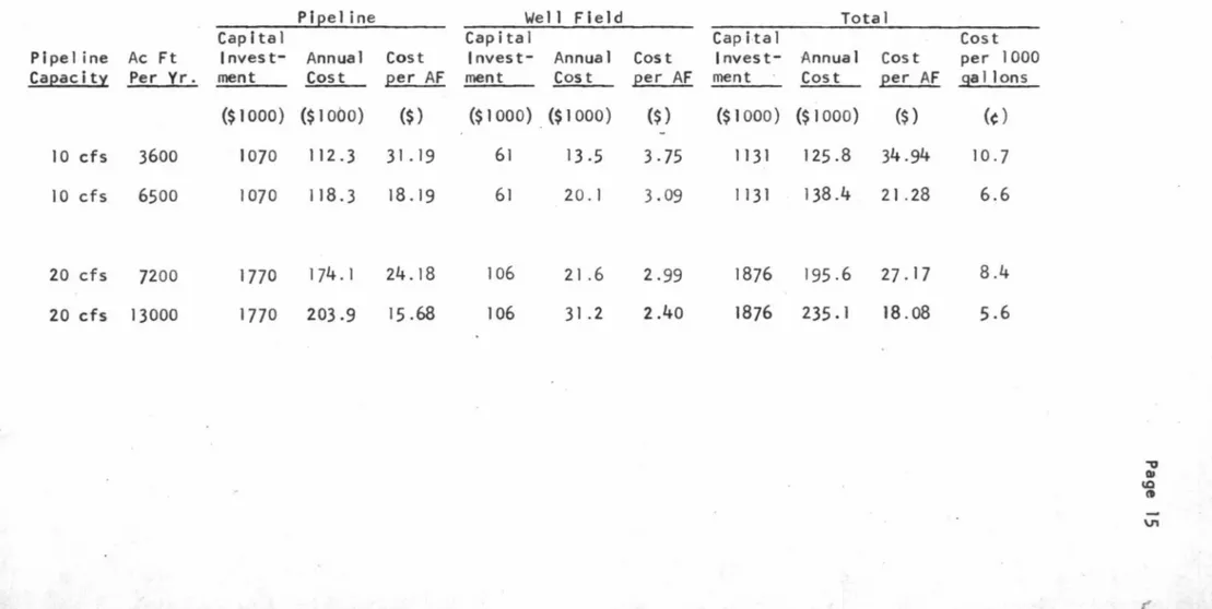
Details of the capital and unit costs of the South Platte River supply are presented in Table No. 9. These unit costs Include amortization of capital cost at 6 percent over a 25-year period. Power for pumping was estimated at 12.5 mil ls per KW hr. Reasonable allowances were made for sin king fund al locations to cover operation, maintenance, and replacement.
An analysis was made to determine cost of a pipe I ine from Horsetooth Reservoir to the plant site for a 10 cfs of capacity, the plpel ine being in operation 8 months of each year. It was determined that the capital cost would be $1,350,000
for an 80,000 foot long concrete pl~ellne. The cost under the assumed conditions
would be approximately 7¢/1,000 gallons.
To determine over-all costs of water supply would require more detailed analyses than time permitted or than reconnaissance nature of the work justified. Based upon the studies made, however, It is our opinion that raw water can be delivered to the plant site, Including uncontaminated Horsetooth Reservoir water via pipe) lne and annual assessments, for the amounts shown below. Costs of domestic water have not been included in the estimates.
Phase I . Phase 11 . Phase ~ 11
7 to 8 cents per 1,000 gallons 8 to 9 cents per 1,000 gallons 8 to 9 cents per 1,000 gallons EMERGENCY SUPPLIES
Connections could be made to the Greeley pipe! ine and Fort Col llns system for emergency water suppl Jes. It would be costly to the cities, however, to provide additional capacity for normal standby purposes and It Is expected that charges to the Industry would have to include these costs. With this In mind, one might consider it more economical to provide one's own usual emergency water.
The domestic pipeline: from the City of Fort Collins would be sized to furnish secondary fire fighting requirements, and thus such water could also be supplied In other emergencies under somewhat extreme conditions which could be negotiated.
Emergency raw water requirements can be economically stored In Windsor Lake. If the fire fighting water system was separate, Windsor Lake could also be used for
back-up fire protection water in addition to suitable gravity storage tanks on ~
high ground to the south.
Emergency treated water storage to cover 24-hour requirements would be available by constructing a 6.0 mg concrete or steel reservoir to the soutb.
SUMMARY AND CONCLUSIONS
A water supply for lndu•trlal use Is available In the FortCol !Ins - Greeley area for requlr~ments which will range from 6 ~o 20 million gallons per day over a
Industrial Water Supply, 22 Novwrhb-er 1967 Page 9 Water in exqess of 20 mgd could be developed for approximately the same unit costs, at least up to a total of 30 mgd. It ls probable that stiff resistance would be encountered, together with rising costs, If one proceeded to develop a water supply much in excess of perhaps 40 mgd on a continuous year-round basis.
Not enough is known at this time of the Industrial water quality requirements nor the quality of supply of the Poudre River at Windsor during the irrigation season to arrive at any firm conclusions on qual tty.
The cost of delivered raw water at the plant site area is estimated to cost from 7 to 9 cents .-per thousand ga 11 ons throughout the per lod of growth from 6 mgd to 20 mgd of water requirements.
Emergency water supplies are available. Such water could be very costly, however, If not planned with substantial care.
Very truly yours, WRIGHT WATER ENGINEERS
Kenneth R. Wright KRW:dld
Month Total Nov. 575 Dec. 575 Jan. 575 Feb. 575 March 575 Apr i 1 575 May 575 June 575 July 575 Aug. 575 Sept. 575 Oct.
...212
Totals 6900 \ TABLE NO. 2INDUSTRIAL WATER SUPPLY IN ACRE FEET PHASE I - 1980
.
WATER REQUIREMENTS WATER SUPPLY
Poudre Poudre
Cooling Process Dorne st i c Great Wes tern Great Wes tern C.B.T.
Water Water Water Direct Ri~ Windsor Lake Horsetooth
185 375 15 100 460 185 375 15 - 100 460 185 375 15 100 460 185 375 15 100 460 185 375 15 100 460 185 375 15 300 100 160 185 375 15 560 185 375 15 560 185 375 15 560 185 375 15 560 185 375 15 360 200
.JM
..J1i
..Ji
-
-
560 2220 4500 180 2900 600 3220 Municipal City of Fort Collins 15 15 15 15 15 15 15 15 15 15 15...12.
180 "'O Ill ta t9 -0 I I \Page 11 TABLE NO. 3
INDUSTRIAL WATER SUPPLY IN ACRE FEET PHASE 11
-
1990WATER REQUIREMENTS WATER SUPPLY
Poudre Poudre ML. n ici[2al Poud re Poudre
Cooling Process Domestic Great Western Grea t Western C. B. T. Cit y of Add it ional Remainder of
Month Total Water Water Water Direct Rights Wi ndsor Lake Horsetooth Fort Collins Direct Right s Windsor Lake
Nov. l l 50 325 795 30 100 920 30 100 Dec. l l 50 325 795 30 100 920 30 100 Jan. 1150 325 795 30 160 920 30 100 Feb, 1150 325 795 30 lQO 920 30 100
•
March 1150 325 795 30 lQO 920 30 100 Apr i 1 1150 325 795 30 300 lao 320 30 300 100 May 1150 325 795 30 1000 30 120 June 1150 325 795 30 700 30 420 July 1150 325 795 30 1000 30 120 Aug. 1150 325 795 30 750 30 370 Sept. 1150 325 795 30 360 400 30 360 Oct. 1150..E.2.
...122.
30 1120 ..JQ Totals 13800 3900 9540 360 4110 600 6440 360 1690 600 TABLE NO. 4INDUSTRIAL WATER SUPPLY IN ACRE FEET
PHASE I I I - ULTIMATE So. Platte
Well Field Nov. 1910 540 1320 50 100 975 50 100 685 Dec. 1910 540 1320 50 100 975 50 100 685 Jan. 1910 540 1320 50 100 975 50 100 685 Fe b. 1910 540 1320 50 100 975 50 100 685 March 1910 540 1320 50 100 975 50 100 685 April 1910 540 1320 50 300 100 975 50 300 100 85 May 1910 540 1320
so
1000 50 860 June 1910 540 1320 50 700 50 700 460 July 1910 540 1320 50 1000 50 860 Aug. 1910 540 1320 50 750 50 750 360 Sept. 1910 540 1320 so 360 975 50 360 165 Oc t. 1910 ~ 1320-..29.
-212.
-22..
...§.§.2.
Totals 22920 6480 15840 600 4110 600 7800 600 3830 600 5380Phase 1. 2. Phase 1. 2. 3. Phase 1 • 2.
3.
Phase Phase Phase Phase Phase Phase TABLE NO. 5ESTIMATED COST OF WATER RIGHTS
Great Western Direct Flow and Storage Rights, Lump Sum· CBT Project Water - 4200 Units@ $150 each
I J
CBT Project Water - 4100 Units@ $150 each Additional Direct Flow Water Rights in Poudre* Remainder of Windsor Reservoir, or equivalent
600 acre feet@ $125
111
CBT Project Water - 1700 Units@ $150 each South Platte Direct Flow Rights, Lump Sum South Platte Reservoir Storage Water, Lump Sum
Total Estimated Water Right Cost
1 Unit Cost of Water Rights = 3.7 cents/1000 gallons**
11 II II II II II = 3.7 cents/1000 gallons
111 11 II II II II = 3.0 cents/1000 gallons
I Capital Cost of Water Rights = $324/gpm **
II II II II II II = $322/gpm 111 II II II II II = $264/gpm $ Page 12 750,000 630,000 $1,380,000 $ 615,000 675,000 75.000 $1,365,000 255,000 300,000 450,000 $1,005,000 $3,750,000
*Poudre Direct Flow Rights over~acquired in Phase I I but fully used in Phase I I I
Industrial Water Supply, 22 N<>v.ember · 1'967 Page 13 TABLE NO. 6
Q.UAL ITV OF WATER SOUTH PLATTE ALLUVIUM
BIG THOMPSON TO POUDRE
Hard-(ppm) ness
Date of S 111- Cal- Sod!- Sul- Chlo- NI- , as
Cortect. ca Iron Mang. clum ~ um phqte ride trate
ill
· CaC03.e..tL
10/13/60 20 0.14 0.00 127 44 114 320 75 34 943 499 10/ 1/62 20 0.06 0.00 143 38 114 316 75 33 932 512 7.6 9/20/63 19 0.04 0.00 149 46 132 348 88 32 1010 560 7,5 91 2/64 19 0.02 130 57 120 367
77
37 1030 558 7,9 9/16/65 17 0.03 135 54 120 361 82 49 1050 558 7.8 TABLE NO. 7QUALITY OF SURFACE WATER IN POUDRE AND SOUTH PLATTE RIVERS
(ppm)
Hard-ness
Date of
s
111- Cal- Sod I- Sul- Chlo- NI- asCollect. ca Iron clum um Pot. phate ride trate
ill.
CaC03pH
Samele from Poudre near Greele~ three miles from mouth
12/17/63 20 0.41 170 132 16 323 38 o.6 1360 850 8.0
3/18/64 14 0.47 184 170 7.2 816 87 10 1730 895 7,9
6/16/64 12 0.72 144 120 5 .4 614 57 3.6 1240 665 7.8
9/19/64 8.2 0.16 158 138 5,3 648 70 5 .1 1360 720 8. l
Sample from South Platte near Kerse~ 2.2 miles downstream from Poudre
12/17/63 16 0.58 170 142 9.2 625 48 4.4 1380 755 7,5
3/18/64 13 0. 12 152 174 6.1 674 84 9,3 1420 690 7,7
6/25/64 15 1.1 152 131 6.4 620 40 12 1240 660 7.6
TABLE NO.
8
MISCELLANEOUS CHEMICAL ANALYSES OF WATER SUPPLIES (parts per million)
S ti I- .Ca 1- Sodi- Sul-
Chlo-~ .ca Iron cium ~ um f2.!.:_ phate ride
C.B.T. (a) Spring 164
..
--
--
15
2.7
8. I
---
3.9
1.8
Ft. Coll Ins (b)
8/27/60
7.5
0.23
4.2
1.1
1.5 o.6
4.4
0. I
Ft. Co
111
ns5/23/51
9.1
o.04
12
l.O
2.9 0.6
25
2.0
Windsor {c)
8/27/60
7.3
0.24
4.3
1.5
l .8 0.6
5.5
0.3
WI ndsor
5/23/51
9.2
0.02
12
2.3
4.2
2.24.0
1 .5
Johns town ( d)
4/28/60
3.7
0.89
246.6
7. l
---
46
0.2
Mil I iken {e)
4/28/60
17
0.09 186
88
177
---
758
29
LaSalle (f)
10/13/60
20
0.14 127
44114
---
320
75
{a) Based on sample from Colorado River below Granby Reservoir (b) Representative of Poudre upstream from Irrigated lands
{c) Supplied by Greeley. Additional taps subject to restrictions by Greeley (d) From Big Thompson River
(e) Ground water from alluvium of Big Thompson near South Platte River (f) Ground water from alluvium of South Platte one mile southeast of river
Ni-trate TDS
---
76
0.0
36
0.8
770.1
42
l.3
710.2
132
241620
34
943
Hard-ness as CaCQl48
15
34
17
40
87
825
499
pH7.5
6.6-6.8
6.4
7.3
6.8
7.3
7.3
-0 QI'°
(t ~ •TABLE NO. 9
ESTIMATED COSTS OF SOUTH PLATIE RIVER WATER (Not including water rights)
..
Construction costs include 56,000 feet of pipeline, pumping plants, structures, stream, road and canal crossings, co1T1T1unications, access roads, right of way, well field, pumps, and gathering lines. Annual costs
based upon 25-year amortization period, 6 percent interest, and power at 12.5 mills per
KWH.
Plpel ine Ac Ft Capac:ity Per V_r. 10 cfs 3600 10 cfs 6500 20 cf s 7200 20 cfs 13000 Pl2el ine Capital
Invest- Annual Cost
ment Cost 2er AF
($1000) ($1000) ($) 1070 112 .3 31. 19 1070 118.3 18.19 l 770 l 74. l 24. 18 1770 203.9 15.68 We 11 FI el d Capital Invest- Annual ment Cost ($1000) ($1000) 61 13 .5 61 20. l 106 21 .6 106 31.2 Cost 2er AF ($) -3. 75 3 .09 2.99 2.40 Total Capital
Invest- Annual Cost
ment Cost Eer AF
($1000) ($I 000) ($) 1131 125.8 34.94 I 131 138.4 21 .28 1876 195.6 27. 17 1876 235.1 18.o8 Cost per 1000 _gal Jons (¢) 10.7 6.6 8.4 5.6 '"'O Ill l.Q (I V1 •