Agricultural expansion impacts on
wetland ecosystem services from
Kilombero Valley, Tanzania
Edmond Alavaisha
Edmond Alavaisha Agricul tur al expansion impacts on w etland ecosystem services fr
om Kilomber o V al le y, Tanzania
Dissertations in Physical Geography No. 7
Doctoral Thesis in Physical Geography at Stockholm University, Sweden 2020
Department of Physical Geography
ISBN 978-91-7911-184-7 ISSN 2003-2358
Edmond Alavaisha
has BSc. in Aquatic Environmental Science and Conservation and MSc. in Marine Sciences form University of Dar es Salaam. His main research interests are in wetland ecology, agroecosystems, ecosystem services and ecological conservation using local available practices on landscape.
Development of irrigation and changes in agricultural management practices influence water quality and soil fertility. With the expansion and intensification of agriculture under the Kilimo kwanza (First agriculture) initiative, more knowledge on the effects of land use changes and associated ecosystem functioning is critically needed. This study is focused on small-scale irrigation schemes to understand the effects of agriculture expansion and farming practices on nutrients, water quality and ecosystem services (ES) in Kilombero Valley, Tanzania. The major land use change in the valley during the last three decades was transformation from forest, bushland and grassland into cultivated land. Both irrigation and fertilization contributed to soil carbon and nitrogen accumulation in crop field, declining in concentration with depth. However, such management practices and agricultural land expansion had impact on several ES, especially water quality in streams. Furthermore, when evaluated, macroinvertebrates indices were found to be a good indicator of water quality and a complement to chemical and physical water analysis. Irrigation farming produced more food compared to rainfed farming, and also other ES such as flood regulation, erosion control and several cultural services. Nevertheless, the services delivery and need were not uniform depending on the river discharge. The thesis shows the importance to use farming management to enhance soil fertility, preserve soil structure, and water quality but also the need for proper irrigation management to prevent flooding and erosion, and conserve natural vegetation. To enhance nature conservation and secure future supply of ES in the valley, investment in irrigation infrastructures should be done at small-scale, leaving remaining part of the valley to recover from degradation
Agricultural expansion impacts on wetland
ecosystem services from Kilombero Valley,
Tanzania
Edmond Alavaisha
Academic dissertation for the Degree of Doctor of Philosophy in Physical Geography at Stockholm University to be publicly defended on Thursday 24 September 2020 at 13.00 in De Geersalen, Geovetenskapens hus, Svante Arrhenius väg 14.
Abstract
Land use change has major impact on the world’s wetland ecosystems and biodiversity. The motivation behind this change has been to increase agricultural production, often resulting in negative effects on water quality and soil fertility. Tanzania has carried out a large expansion and intensification of agriculture under the Kilimo kwanza (First agriculture) initiative which has triggered the need for better knowledge on land use change effects and associated ecosystem functioning. This thesis considers small-scale irrigation schemes to understand the effects of agriculture expansion and farming practices on nutrients, water quality and ecosystem services (ES) in Kilombero Valley, Tanzania. The study approach is multidisciplinary involving interviews, remote sensing, geographical information system techniques, and in-field soil and water ecological sampling. The major land use change in the valley during the last three decades was transformation from forest, bushland and grassland into cultivated land. The rate of change was faster adjacent to irrigation schemes and most changes occurred downstream irrigation canals, close to the floodplain. Irrigation and fertilization contributed to soil carbon and nitrogen accumulation in crop fields, which both declined in concentration with depth into the soil. However, such management practices and agricultural land expansion had impacts on several ES – especially water quality in streams. Streams surrounded mainly by cultivated land, as well as downstream areas, had lower water quality compared to streams with less settlement, more natural vegetation and upstream areas. Furthermore, when evaluated, macroinvertebrates indices were found to be a good indicator of water quality and a complement to chemical and physical water analysis. Irrigation farming produced more food compared to rainfed farming, and also other ES such as flood regulation, erosion control and several cultural services, depending on the river discharge. The thesis shows the importance to use irrigation/fertilization management to enhance soil fertility and preserve soil structure, but also the need for proper irrigation management to prevent flooding and erosion, conserve natural vegetation, and protect water quality. To enhance nature conservation, preserve biodiversity and secure future supply of ES in the valley, investment in irrigation infrastructures should be done at small-scale to mitigate the large-scale exploitation of Kilombero wetland.
Keywords: Ecosystem services, land use change, management practices, fertilization, irrigation, water quality, and smallholder. Stockholm 2020 http://urn.kb.se/resolve?urn=urn:nbn:se:su:diva-182600 ISBN 978-91-7911-184-7 ISBN 978-91-7911-185-4 ISSN 2003-2358
Department of Physical Geography
AGRICULTURAL EXPANSION IMPACTS ON WETLAND ECOSYSTEM SERVICES
FROM KILOMBERO VALLEY, TANZANIA
Agricultural expansion impacts on wetland
ecosystem services from Kilombero Valley,
Tanzania
©Edmond Alavaisha, Stockholm University 2020 ISBN print 978-91-7911-184-7
ISBN PDF 978-91-7911-185-4 ISSN 2003-2358
Published articles reprinted with permission from publisher Distributor: Department of Physical Geography, Stockholm University Cover photo: Landscape of Kilombero Valley by Edmond Alavaisha Printed in Sweden by Universitetsservice US-AB, Stockholm 2020
DEDICATION
To my parents Mmeku
Thadeus and Msheku
Alberia (mama Dessy)
Abstract
Land use change has major impact on the world’s wetland ecosystems and biodiversity. The motivation behind this change has been to increase agricultural production, often resulting in negative effects on water quality and soil fertility. Tanzania has carried out a large expansion and intensification of agriculture under the Kilimo kwanza (First agriculture) initiative which has triggered the need for better knowledge on land use change effects and associated ecosystem functioning. This thesis considers small-scale irrigation schemes to understand the effects of agriculture expansion and farming practices on nutrients, water quality and ecosystem services (ES) in Kilombero Valley, Tanzania. The study approach is multidisciplinary involving interviews, remote sensing, geographical information system techniques, and in-field soil and water ecological sampling. The major land use change in the valley during the last three decades was transformation from forest, bushland and grassland into cultivated land. The rate of change was faster adjacent to irrigation schemes and most changes occurred downstream irrigation canals, close to the floodplain. Irrigation and fertilization contributed to soil carbon and nitrogen accumulation in crop fields, which both declined in concentration with depth into the soil. However, such management practices and agricultural land expansion had impacts on several ES – especially water quality in streams. Streams surrounded mainly by cultivated land, as well as downstream areas, had lower water quality compared to streams with less settlement, more natural vegetation and upstream areas. Furthermore, when evaluated, macroinvertebrates indices were found to be a good indicator of water quality and a complement to chemical and physical water analysis. Irrigation farming produced more food compared to rainfed farming, and also other ES such as flood regulation, erosion control and several cultural services, depending on the river discharge. The thesis shows the importance to use irrigation/fertilization management to enhance soil fertility and preserve soil structure, but also the need for proper irrigation management to prevent flooding and erosion, conserve natural vegetation, and protect water quality. To enhance nature conservation, preserve biodiversity and secure future supply of ES in the valley, investment in irrigation infrastructures should be done at small-scale to mitigate the large-scale exploitation of Kilombero wetland.
Sammanfattning
Förändring i markanvändning påverkar våtmarkernas ekosystem och biologiska mångfald globalt. Motivet till förändringen har varit att öka mängden produktiv jordbruksmark, vilket har inneburit en utveckling av olika bevattningssystem med negativ påverkan på vatten- och jordkvalitet som följd. Tanzania har genomfört en stor utvidgning och intensifiering av jordbruket under initiativet Kilimo kwanza (första jordbruket); ett initiativ som kräver ny kunskap om markanvändningsförändringarnas effekter på ekosystemen, och dess tjänster och funktioner. Denna avhandling undersöker småskaliga bevattningssystem för att förstå effekterna av en ökad mängd jordbruksmark och förändrade jordbruksmetoder på näringsämnen i jorden, vattenkvalitet och ekosystemtjänster i Kilombero våtmarksområde, Tanzania. Studiens ansats är tvärvetenskaplig och involverar intervjuer, fjärranalys, geografiska informations (GIS) samt ekologiska fältundersökningar av jord och vatten. Den stora markanvändningsförändringen i Kilombero under de senaste tre decennierna var omvandlingen från skog, buskmark och gräsmark till odlad mark. Förändringshastigheten var snabbare i anslutning till bevattningssystemen och de flesta förändringarna skedde nedströms bevattningskanalerna, nära flodbädden. Både bevattning och gödsling bidrog till att kol- och kväveanrikningen i marken minskade; koncentration minskade även med ökat jorddjup. Denna typ av brukande samt utvidgning av jordbruksmark påverkade flera av jordbrukslandskapets ekosystemtjänster, särskilt vattenkvaliteten i närliggande vattendrag. Bäckar som huvudsakligen omgavs av odlad mark, men även områden nedströms, hade sämre vattenkvalitet jämfört med bäckar omgivna av färre bosättningar, mer naturlig vegetation och uppströmsområden. En utvärdering av olika makroinvertebrats-index visade att dessa kan vara bra indikatorer på vattenkvaliteten och ett komplement till kemisk-fysiska vattenanalyser. Odling som nyttjade konstbevattning producerade mer mat jämfört med odling som baserades på regnvatten enbart, och även andra ekosystemtjänster så som översvämningsreglering, erosionskontroll och ett antal kulturella tjänster gynnades av konstbevattning i liten skala. Ekosystemtjänsterna varierade dock beroende på årstid och vattenflöde. Avhandlingen visar vikten av att använda småskalig konstbevattning och gödsling för att förbättra markens fertilitet och bevara jordstrukturen, men också behovet av korrekt bevattningshantering för att förhindra översvämningar och erosion, samt bevara naturlig vegetation. Genom att övervaka vattenkvalitet med hjälp av makroinvertebrater kan försämring av både vattenkvalitet och förlust av biologisk mångfald upptäckas i ett tidigt skede, vilket bidrar till bättre kontroll och skötsel av våtmarker. För att förbättra naturskyddet, bevara biologisk mångfald och säkerställa framtida ekosystemtjänster i Kilombero, bör investeringar i bevattningsinfrastrukturer främst göras småskaligt, vilket kan minska den storskaliga exploateringen av Kilomberos våtmarker.
Thesis content
The thesis consists of a summary and four appended papers (referred to as Paper I - IV) listed below:
I. Alavaisha, E., Mbande, V., Börjeson, L., & Lindborg, R. Effects of land use change
related to small-scale irrigation schemes in Kilombero wetland, Tanzania. Manuscript
II. Alavaisha, E., Manzoni, S., & Lindborg, R. (2019). Different agricultural practices
affect soil carbon, nitrogen and phosphorous in Kilombero-Tanzania. Journal of
environmental management, 234, 159-166. https://doi.org/10.1016/j.jenvman.2018.12.039
III. Alavaisha, E., Lyon, S. W., & Lindborg, R. (2019). Assessment of Water Quality Across
Irrigation Schemes: A Case Study of Wetland Agriculture Impacts in Kilombero Valley, Tanzania. Water, 11(4), 671. https://doi.org/10.3390/w11040671
IV. Alavaisha, E., & Lindborg, R. Smallholder perceptions on ecosystem services
The contributions from the authors listed for each paper
Paper I: EA designed the study, EA and VM conducted fieldwork and analysis of data in
collaboration with GIS unit of University of Dar es Salaam, EA and VM wrote the manuscript, RL and LB supervised the research.
Paper II: EA and RL conceptualize and design the study, EA prepare sampling protocols,
conducted fieldwork, data analysis and wrote the first draft. RL and SM supervised the study and provide technical input in preparation and writing of manuscript.
Paper III: EA conceived the idea of this paper, conducted fieldwork, laboratory analysis
(macroinvertebrates), statistical analysis and wrote a major part of the manuscript. RL and SWL were involved in providing technical input during fieldwork and writing of paper.
Paper IV: EA conceptualize and conducted fieldwork, analysed data and writing first draft. RL
supervise the study, providing technical inputs.
Abbreviation used: EA - Edmond Alavaisha, RL - Regina Lindborg, SWL - Steve W. Lyon, SM -
Table of Contents
1. Introduction ... 1
2. Theoretical background and context ... 4
2.1 Wetland ecosystems ... 4
2.1.1 Tanzania’s wetlands ... 5
2.1.2 Wetland loss ... 5
2.2 Ecosystem services from wetlands ... 6
2.3 Water quality —biological monitoring ... 8
2.4 Soil nutrients and farming practices ... 9
2.5 Tanzanian land use policy for agriculture ... 12
2.6 Farming practices and supply and demand of ecosystem services ... 13
3. Aim and objectives ... 14
4. Methods ... 16
4.1 Study area description ... 16
4.1.1 Climate ... 16
4.1.2 Ecosystems, biodiversity and ecosystem services ... 17
4.1.3 Livelihood ... 18
4.2 Data collection and analysis methodology ... 18
4.2.1 Interviews ... 18
4.2.2 Mapping and spatial data ... 19
4.2.3 Biophysical and motoring data ... 19
4.3 Data compilation and statistical analyses ... 20
5. Results and discussion ... 22
5.1 Key findings ... 22
5.2 Land use along irrigation schemes ... 23
5.3 Variation of SOC and nutrients with fertilization and irrigation management ... 25
5.4 Impacts of agriculture on water quality ... 27
5.5 Perceptions of ecosystem services from agricultural practices ... 30
5.6 Ecosystem services under agriculture land use expansion ... 31
6. Conclusion ... 33
6.1 Management framework and policy recommendations ... 33
Acknowledgments ... 35
Financial support ... 36
1
1. Introduction
From global to local scale, wetland ecosystems are under severe pressure due to population increases, increasing demand for agricultural land and timber, and competition for water from farming (irrigation), forestry, households and industries. Population increases and demand for food (and food security) has led to agro-innovation and targeted development throughout the world. An example of such targeted development can be found in Tanzania. Recently, under the policy of Kilimo Kwanza (Agriculture First), Tanzania started an initiative known as the Southern Agricultural Corridor of Tanzania (SAGCOT), which aims at rapidly developing agricultural potential through large and small-scale irrigation schemes, in a sustainable way (Lugangira, 2018; SAGCOT, 2011). In the Southern highlands zone of SAGCOT, Kilombero wetland has been identified as the potential area for implementation of agricultural intensification and expansion. This investment in the Kilombero wetland’s development is expected to contribute to reginal food production and to the livelihood of communities since more than 70% of Tanzania’s population living in rural areas and depend on agriculture for their livelihood (World Bank, 2019). However, sustainable agro-development can only be achieved through a clear understanding of the challenges associated with continued ecosystem functions when landscape changes, particularly as these changes relate to water-soil resources within a developing agricultural sector.
Why study Kilombero Valley wetland?
Kilombero wetland is an interesting and regionally relevant case study in this regard as it is one of the largest wetland ecosystems in Tanzania. It regulates the flow of the Kilombero River and great Rufiji River and is an important source of nutrients and sediment for downstream mangrove-seagrass-coral ecosystems (Kamukala, 1993; RAMSAR, 2002). Kilombero River basin is known for its contribution to the national and regional food security (Bassi et al., 2018; Johansson, 2018; Milder et al., 2013) — which rely on water availability and soil fertility. Parallel, Kilombero River basin is also a hotspot for different land use interests related to agriculture, wildlife conservation, forestry and water (SAGCOT, 2011; Scherr et al., 2013; Smith, 2016). These different land uses have led to major environmental impacts in the wetland itself and to downstream ecosystems. Impacts include excess of nutrients and agrochemicals in runoff, and diversion of water flows by irrigation and sedimentation in channels (Connors, 2015; Leemhuis et al., 2016; Nindi et al., 2014; Seeteram et al., 2019).
Until the mid-20th Century, people in Kilombero Valley lived scattered over the wetland area. In
the 1970s, after the Villages and Ujamaa Villages Act No. 21, people were resettled into centralized villages created as part of the ‘villagization’ program (Kikula, 1997). This created new settlements in many parts of Kilombero increasing the rate and extent of land use/cover change in the valley, mainly through investment in rice and sugarcane cultivation (Colin, 2018; Kato, 2007; Nindi et al., 2014). In response to agricultural expansion, conservation efforts setting aside important wetland areas in Kilombero began (RAMSAR, 2002). In parallel to conservation, there was also a shift to intensive irrigation farming to reduce land degradation pressure on other parts of the valley. However, over the last two decades the use of wetlands for agriculture has increased
2
because of increasing population and changes in rainfall patterns (Connors, 2015; URT, 2012), bringing the idea of improving and investing in irrigation farming.
Potential impacts of agricultural intensification on agroecosystem
Commercialization to increase food production often transforms landscapes into cultivated land which can result in a loss of native vegetation, depletion of soil nutrients and loss of soil through erosion. Moreover, such changes can diminish important wetland ecosystems services (ES) (Bergius et al., 2020; Coates et al., 2013), for example the availability of fresh water, sustainability of food production, and the landscapes ability to impart erosion control, flood regulation and infiltration of water (Burkhard and Maes, 2017; Leemhuis et al., 2017; Siima et al., 2012). This can ultimately create the mismatch between supply (what services that are generated within an ecosystem) and demand (peoples need for these services) of ES threatening sustainable management at different spatial and temporal scales (Vrebos et al., 2015; Wei et al., 2017). To reduce potential impacts at local scale, empowerment of smallholder farming systems is a potential option to increase production in restricted small areas (e.g. irrigation schemes) while preserving the remaining larger landscape (Altieri, 2009; Fischer et al., 2014; Fraanje, 2018; Happe et al., 2018; Kremen, 2015).
Soil health is also vulnerable under unfettered agricultural management practices. The practices severely affect soil fertility and related soil properties such as soil organic carbon (C), nitrogen (N) and phosphorous (P) levels (Kopittke et al., 2017; Wang et al., 2013) crucial for sustaining food production and environmental quality in general (Espinoza et al., 2013; Pert et al., 2013). Nutrient availability is related to agricultural management practices, e.g., irrigation and fertilization contributed to availability of nutrients (Carrijo et al., 2017; Fang et al., 2006). The amount of water and organic matter addition or chemical fertilizers either increase or decrease amount of accumulated nutrients (Chen et al., 2011; Craine et al., 2007; Fang et al., 2006; Kamoni et al., 2003). However, other practices, for instance tillage cultivation, expose soil aggregates to nutrients loss (Barbosa et al., 2001; Chow et al., 2008). Agricultural intensification may also accelerate changes in water quality because of nutrient leaching to streams and rivers.
Irrigated streams may vary greatly in terms of water chemistry and biota as fertilizers and agrochemicals affect physical-chemical characteristics of surface water and biota (Bobbink et al., 2006; Elias et al., 2014; Kaaya, 2014; Kaaya et al., 2015) at different spatial and temporal scales (Chow et al., 2008; Norris and Thoms, 1999). For example, downstream sites or sites in the proximity to sources of pollution are typically more affected in terms of sediments, nutrients level and species compositions (Allan, 2004; Wallace, 2002). Excess leaching of nutrients cause algal accumulation and decrease dissolved oxygen in aquatic and wetland environments (Castellanos Romero et al., 2017; Munn et al., 2002), affecting assemblage of macroinvertebrates. Likewise, excess sediments may kill macroinvertebrates through siltation and gill clogging, and can cause a reduction in light penetration influencing primary production (Castellanos Romero et al., 2017). Hence, there is a need for effective assessment and monitoring tools which are cost effective using simple tools at local scale (Hauer and Resh, 2017; Norris and Thoms, 1999; Seeteram et al., 2019).
3 Prolonging growing seasons through irrigation has frequently been adopted as a way to intensify agriculture in order to increase food production. However, the practices involved often introduction of excess fertilizers, herbicides and frequently tillage leading to loss of aquatic biodiversity and associated ES. Expansion and intensification of agriculture in the implementation of the Kilimo Kwanza is expected to escalate pressure thereby increasing management challenges associated with water quality, nutrient and ES losses. Therefore, the overall aim of this thesis is to present the potential impacts of agricultural expansion and intensification on land use change, with special focus on soil quality and fertility, water quality and quantity and ES to provide local management options for nature conservation and preserving essential ecosystem functions of the Kilombero Valley wetland.
4
2. Theoretical background and context
This section reviews the current state-of-science around the wetland agriculture land use change to understand the potential implications for ES and conservation of wetlandscapes. The theoretical background presented here provides a context for considering the specific case study of agricultural expansion and intensification on ecosystem services, soil nutrients and water quality in Kilombero Valley wetland.
2.1 Wetland ecosystems
Wetlands are distinct ecosystems that seasonally or permanent are inundated with water. Although wetlands occupy a quite small part of Earth’s surface area, about 1.5% (Ramsar Convention on Wetlands, 2018; Zedler and Kercher, 2005), they are important for ecosystem services (ES) provision and deliver about 40% of global ES (Zedler and Kercher, 2005). Most wetlands are natural, while very few are man-made (Maltby, 2009; Ramsar Convention on Wetlands, 2018). Wetlands, being at the transition between land and water, can support both aquatic and terrestrial species, as well as wetland specialists including, for example, many macroinvertebrates species (De Troyer et al., 2016; Hauer and Resh, 2017; Pallottini et al., 2017; Usseglio-Polatera et al., 2000). The extended presence and absence of water forms hydric soil, an environment that favor plants and animals adapted to live in wet and soft substratum (Milton et al., 2018; Rebelo et al., 2010; Zedler and Kercher, 2005). Most wetland in tropical, arid and semiarid landscapes are seasonal, i.e. they are dry at least one season every year. Wetlands are also important in the absence of water as they are often used for agricultural because of their fertile and humid soils (Bouman et al., 2007; Verhoeven and Setter, 2010).
Wetlands are considered among the most productive ecosystems in the world and are comparable to rain forests (Zedler and Kercher, 2005; Zhang et al., 2007). They harbour a great variety of species of microbes, plants, insects, amphibians, reptiles, birds, fish and mammals. The spatial and temporal distribution of flora and fauna depend on landscape climate interaction and geology (Seeteram et al., 2019; Zedler and Kercher, 2005), quantity and movement of water (Muñoz-Mas et al., 2019) – the latter contributing to distribution and dispersion of the plants and animals that inhabit wetland. Being an important source of nutrients and energy, wetlands drive other ecosystems, especially when considering issues of food chain (Carpenter et al., 2006; Dinesen, 2016; Zhang et al., 2007). Although difficult to quantify directly, wetlands are thought to be important biological hubs, which supply energy to nearby ecological cycles (Rebelo et al., 2010). Dead plant leaves and stems break down in the water to form small particles of organic material called detritus (Fabrizi et al., 2010; Mitsch et al., 2005), which form bases of energy in the system. This enriched material can feed many small aquatic insects, and small fish that are food for larger predatory fish, reptiles, amphibians, birds and mammals (Bobbink et al., 2006; Norris and Thoms, 1999; Peel et al., 2019). Furthermore, those materials may contribute to nutrients which make lower parts of rivers and flood plain more fertile (Bonada et al., 2006; Robards et al., 1994) and preferred for agriculture.
5
2.1.1 Tanzania’s wetlands
In Tanzania, about 10% of the surface area is covered by wetlands, mainly flood plains and rivers such as Usangu, Pangani, lower Rufiji, Wami and Ruvuma flood plains, and Kilombero wetland (Kamukala, 1993; Wilson et al., 2017). Currently, wetlands are under pressure from agriculture expansion (growth of agricultural land, e.g. arable land) and intensification (increase in agricultural production per unit of inputs which may be labour, land, time, fertilizer, seed, feed or cash) (Angelsen, 1999; Giller et al., 1997; Tittonell, 2014), resulting in loss of wetland area and their associated ES (Gordon and Enfors, 2008). As an effort to minimize the impacts, the government established wetland protected areas. At present Tanzania has four sites designated as wetlands of international importance: Malagarasi-Muyovozi, Lake Natron Basin, Rufiji-Mafia Kilwa and Kilombero Valley Floodplain (KVFP) (Materu et al., 2018; URT, 2014). These areas are of socio-ecological importance that have impact beyond their border (Colin, 2018; Leemhuis et al., 2017, 2016). For example, they play an essential part in local and global water cycles and are the crucial link between water, food, and energy. Balancing systems at this nexus is a challenge for our society in the context of sustainable agricultural development and management (Leemhuis et al., 2017).
The Kilombero Valley is one of the most fertile wetlands in Tanzania. As such, it is under growing pressure from agricultural expansion and an ever-growing human population (Colin, 2018; Leemhuis et al., 2017; Msofe et al., 2019). These developments not only affect the ability of the wetland to supply ES in the long-term, but also the economy of surrounding communities. A large reduction in miombo woodland and encroachment of Ramsar-protected wetlands has already been observed (e.g. Johansson and Abdi, 2020; Johansson and Isgren, 2017; Msofe et al., 2019; Munishi and Jewitt, 2019). The increase of local population and migration of pastoralist, agro-pastoralist and others from different parts of the country resulted in a large resource demand, hence the utilization of wetland resources has increased over time (Dinesen, 2016; Kangalawe and Liwenga, 2005). The continued increase and expansion of both large and small-scale farming areas is threating the presence and productivity of the ecosystem through loss of natural vegetation cover, loss of biodiversity, loss of upper soil cover and fertility. These threats are driven by rapid conversion of natural land cover for agriculture and an influx of livestock (Dinesen, 2016). Under the current commercial agriculture emphasis, namely the SAGCOT initiative, there is a risk of further destruction to maximize agriculture productivity at the expense of Kilombero’s natural resources (Johansson and Isgren, 2017; Smith, 2016); especially since the wetland does not have an integrated management plan, despite being declared protected (Majamba, 2004; Materu et al., 2018).
2.1.2 Wetland loss
Globally, wetlands are under pressure from direct and indirect human activities. Direct human activities include different types of land use change (Milton et al., 2018), causing wetland degradation and loss by changing water quality and quantity; increasing pollution and changing the species composition. Indirect (non-ecological) activities include natural hazards and lack of coordination in the management of wetlands (Finlayson and Rea, 1999). As an effect, about 87% of global wetlands have been lost since 18th Century (Davidson 2014), with the rate expected to increase (Ramsar Convention on Wetlands, 2018; Zedler and Kercher, 2005). A majority of local
6
and global assessments report losses of water inundation area in both open natural and human-made wetlands (Schroeder et al., 2015). The average annual rate of natural wetland loss estimated by the Wetland Extent Trends (WET) Index is -0.78% a year, slightly above of the Africa value of about -0.7% a year (Ramsar Convention on Wetlands, 2018). Decreases have been driven mainly by population increases, urbanization and expansion of agriculture.
Tanzanian wetlands have experienced more land use change from agricultural expansion. For instance, a population influx at Kilombero and investment in agriculture contributed to the transformation of the wetland (Johansson and Isgren, 2017; Msofe et al., 2019; Munishi and Jewitt, 2019; Thonfeld et al., 2020). Seki et al. (2018) reported the trend of wetland shrinking as a threat to migratory bird species. Furthermore, Ideva (2011) indicated the development of hydroelectric power and expansion of faming contributed to higher nutrients downstream, resulting in extinction of the endemic species. Despite not having quantified the rate of wetland loss in Kilombero, a diminishing of ES and a conversion of forest lands to farm lands would provide a good proxy for wetland loss.
2.2 Ecosystem services from wetlands
Wetlands offer goods and services contributing to human well-being, where the most crucial ones are provision of food, water purification, flood protection, stabilization, groundwater recharge and streamflow maintenance (Figure 1) (Berbés-Blázquez et al., 2016; Millennium Ecosystem Assessment, 2005). Wetlands also help reduce impacts from storm discharge, store carbon (C), regulate nutrients and control pests (Burkhard et al., 2014; Clarkson et al., 2013; Rodríguez-Ortega et al., 2018; Schröter et al., 2019). They are also important habitat for wildlife, both aquatic and terrestrial, including endangered species. The values of wetlands to humans depend on a complex set of relationships between different wetland functions (Boelee, 2011; Milton et al., 2018). Changes that affect biodiversity will affect ecosystem functioning; for example, losses of specialized pollinators (Chow et al., 2008) and wetland shredders that are consuming organic materials (Usseglio-Polatera et al., 2000). Such changes may lower crops production and limit availability of nutrients in the soil, reduce the complexity of food webs, and soil related ES (Clarkson et al., 2013; Rodríguez-Ortega et al., 2018).
7 Figure 1: Wetland functions and water related ecosystem services, including provision, supporting, regulating and culture.
Most communities in Kilombero are entirely depend on natural resources found in wetlands. Apart from agricultural activities, they use natural products from wetlands, including fish, wood products, wild fruits and vegetables (Dinesen, 2016; Rebelo et al., 2010; Wilson et al., 2017). Many wetland services are traded in markets, and in many regions rural households are directly depend on these services for their livelihoods. In this case, the services value may be much more important than is reflected in the prices they fetch on local markets. The economic benefits associated with these wetland ES can therefore be significant (Kihila et al., 2015; Nyomora, 2015; Samecka-Cymerman et al., 2004).
Wetland water quality is often protected by sediment traps that retain excess nutrients (Machibya and Mwanuzi, 2006). Since Kilombero wetlands interconnect to rivers or ground water, their role in water recharge and purification is essentially important (Figure 1). Aquifers and groundwater are recharged by precipitation that seeps into the ground and surface waters (Hemlin-Söderberg, 2014). Groundwater, in turn, provides water for drinking, irrigation, and maintenance of streamflow, and reservoir levels. Purification improve the quality of surface and groundwater (such as aquifer and lakes) that in turn are used by humans for drinking, irrigation agriculture, fishing, or other activities (Postel and Thompson, 2005; Smith, 2016).
8
Almost any wetland can provide some measure of flood protection by holding excess runoff after a storm and then releasing it slowly. Kilombero wetlands are acting as “natural sponges” that trap and slowly release surface water, rain, groundwater and flood waters (Hemlin-Söderberg, 2014; Maltby, 2009), contributing to water flow regulation and recharge. While wetlands cannot prevent flooding, they do lower flood peaks by temporarily holding water and by slowing the water's velocity (Verhoeven and Setter, 2010). This combined water storage and energy dissipation lowers flood heights and reduces erosion during long rain seasons. The mechanism protect crops and irrigation infrastructures (Duvail and Hamerlynck, 2007) likewise contribute to accumulation of nutrients in the valley flood plain (Massawe, 2015; Monson, 1992).
The wetlands help to protect and maintain the soils from the erosive forces of water movements (Fischer, 2013; Maltby, 2009). Their plants act as a buffer zone by dissipating the water's energy and provide stability by anchoring the soils with their root systems. During periods of high streamflow (or high-water levels), vegetation helps to slowdown the water, maintain minimum water levels and speed. In addition, wetlands located along streams, lakes, and reservoirs may release stored water directly into these systems (Senkondo et al., 2017; Smith, 2016), thus also contributing to their maintenance. With these intricate connections with groundwater, streamflow, and lakes and reservoirs make wetlands essential in the proper functioning of the hydrologic cycle (Lyon et al., 2015).
2.3 Water quality —biological monitoring
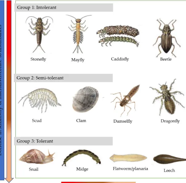
Changes in water quality, either due to excess nutrients or chemicals, modify aquatic species composition and biodiversity (Muñoz-Mas et al., 2019; Seeteram et al., 2019; Seki et al., 2018). Many rivers, streams, lakes, and reservoirs have been damaged because of increased cultivation upstream (Demars et al., 2012; Ensign and Doyle, 2006; Skinner and Thorne, 2005). Consequentially, ecological imbalance at lower trophic levels impact flora and fauna at higher trophic level. Specifically macroinvertebrates respond to water quality change because of their biological sensitivity. Joao et al. (2012) and Hauer and Resh (2017) indicated that macroinvertebrate biological monitoring provided an integrated approach to assess water and overall environmental quality in a cost effective way. The best way to monitor impact of contaminated runoff is done before wide spread of pollution. For example, De Troyer et al. (2016); Munyika et al. (2014) and Xu et al. (2014) used the concept of indicator species surveying presence and/or absence of taxa to determine the degree of community change as an effect of nutrients pollution. In sub-Saharan Africa, macroinvertebrates indices are becoming common tools for assessing water quality, based on sensitivity to disturbances. Some group of species respond quickly to slight changes (very sensitive), while others can with stand changes (tolerant) (Figure 2). Such capacity is due to ecological and environmental traits associated with the species (Pallottini et al., 2017; Polatera et al., 2000), e.g. worms can survive in anoxic environment because their body has high affinity to oxygen (Osmulski and Leyko, 1986). Studies on macroinvertebrate indices (e.g. South African Scoring System –SASS (Dickens and Graham, 2002) for South Africa, Namibian Scoring System –NASS (Palmer and Taylor, 2004) for Namibia and Tanzanian River Scoring System (TARISS) for Tanzanian rivers (Kaaya et al., 2015)), found that macroinvertebrates may be used as a proxy for organic pollution for monitoring agriculture expansion and intensification over a period of time. However, these indices should be calibrated according to
9 riverine ecology. For that matter, suggested appropriate indices can provide information on the different sources of point and non-point source pollution in aquatic ecosystems.
Figure 2: Macroinvertebrates in relation to their sensitivity to disturbances. Disturbances can be any modification in riverine environment that affect macroinvertebrates for example, change in water chemical, physical composition and land cover change that may alter level of nutrients, turbidity, pH or temperature from normal.
2.4 Soil nutrients and farming practices
Soil harbour the largest pool of organic carbon, estimated to be about three times larger than vegetation and twice that reported in the atmosphere (Lal, 2004). Land use, especially for food production, is responsible for large amounts of loss of soil organic carbon (SOC) to the atmosphere. This is problematic since a the highest amount of SOC is found in top 30 cm soil layer (Gelaw et al., 2014; Jobbágy et al., 2016; Poirier et al., 2009). Loss of SOC differs globally, for example Lal (2004) indicated that about 60% of C is lost in temperate areas, while about 75% is
10
lost in the tropics due to expansion of agriculture. Furthermore, crop and management practices vary at local scale depending on region (Poirier et al., 2009). The rate of carbon loss is expected to increase due to increasing demand for agricultural land to meet the need of growing population. Sanderman et al. (2017) indicated a global C debt due to agriculture of 133 Pg C for the top 2 m of soil, with the rate of loss increasing dramatically in the past 200 years. Nutrients, nitrogen (N) and phosphorous (P), have also received attention in agriculture because they are organic bounded like SOC, improve plant growth and soil quality (Espinoza et al., 2013; Kopittke et al., 2017). Furthermore, C, N and P are affected by different farming practices (Groppo et al., 2015; Kopittke et al., 2017; Lueking and Schepers, 1985; Wang et al., 2013). For example, management by fertilization had either positive (Craine et al., 2007; Livsey et al., 2020) or negative (Adams et al., 2016; Riggs and Hobbie, 2016) effect on SOC depending on the level of soil moisture (Moyano et al., 2013).
Four common agricultural practices have the potential to alter soil and ES: organic matter amendment, tillage, chemical fertilization, and irrigation (Figure 3) (Poirier et al., 2009; Potter et al., 1997; Wang et al., 2016). Organic amendment using plant residual improve physical properties of soil, including structure, water retention, and infiltration (Espinoza et al., 2013; Majumder, 2008). Tillage is a unique type of mechanical belowground disturbance of soils, as it disrupts the soil aggregate and expose soil nutrients and organic matter to atmospheric loss (Murphy, 2014). Chemical fertilization increases inputs of various nutrients, mainly in inorganic states that affect soil structure (Gelaw et al., 2014). Added nutrient help to facilitate either mineralization or mobilization of nutrient to increase production (Carrijo et al., 2017; Espinoza et al., 2013). Irrigation farming is a common agricultural practice in wetland, because of unpredicted rainfall and drought in highland. Depending on the level irrigation and nutrients application, irrigation can cause either accumulation or loss of organic matter and nutrient (Craine et al., 2007; Moyano et al., 2013), therefore lower or increase production. Irrigation promote uptake and mineralization (Kamoni et al., 2003), and sufficient moisture provide media for microbial activity and enhance decomposition processes. When moisture either exceed or goes below threshold level, microbial activities decreased and nutrient accumulate (Figure 4)(Moyano et al., 2013). However, the C:N ratio of added organic amended materials can also contributed to nutrient release, for instance, rice straw residue decompose slower than corn residues because they have low N, which promote mobilization (Griffiths et al., 2012; Kushwah et al., 2014). All these agricultural practices affect soil nutrient, separate or together, in different ways. Understanding the relation between the nutrients and agricultural practices is hence crucial for as increase productivity and reduces C emissions (Lal et al., 2015; Plaza-Bonilla et al., 2015).
11 Figure 3: Farming practices: left (a) is irrigated and fertilized farm, right (b) rainfed and unfertilized farm during dry season (Photo taken by E. Alavaisha at Kilombero Valley).
Figure 4: The relationship between microbial heterotrophic respiration and soil moisture. At dry condition (A) and saturation condition (C), microbes are not active because of less oxygen, resulting to accumulation of organic matter. In contrary at (B) the moisture level allow microbial activities results to breaking down of organic matter. Because of variation in physiological, biochemical, and ecological processes, a peak in respiration occurs at intermediate values of soil moisture. Microbial cell Soil pore Soil particle B C A Saturation environment Dry environment moisture A B C H et er o tr o ph ic r es pi rat io n Organic carbon/ nutrients accumulate Organic carbon/ nutrients decompose
Organic carbon/nutrients accumulate
Microbes (less active) Microbes (less active)
12
Different farming practices is also associated with degradation of water quality. Irrigation farming uses fertilizers to supplement the loss, caused by land use intensification to increase production. Nevertheless, such practices led to water pollution through seepage of nitrates and phosphorous (Nakawuka et al., 2018; Pampolino et al., 2008). Cultivation exposes soil to loss of C, N and P that can be washed to river and lakes, affecting plants, and aquatic animal, e.g. insects, fish through siltation and clogging of gills (Mateo-Sagasta et al., 2017; Pullanikkatil et al., 2015). Excess nutrient can cause bad colour and smell, hindering water for drinking. Nitrate in water above maximum contamination level (>10mg/L) cause health problems to infants and pregnants (Ward, 2009). Reduction of forests that act as terrestrial C sinks, diminished effectiveness of C cycling (Riggs and Hobbie, 2016), and reduction in biodiversity associate with vegetation, due to excess nutrients (Damanik-Ambarita et al., 2016; Marques et al., 1999). Research suggests a transient increase in C emissions from soils once forests are cut, but over time regenerating forest can have lower C emissions than unmanaged intact forests (Ford and Keeton, 2017; Templer et al., 2005).
2.5 Tanzanian land use policy for agriculture
In Tanzania, irrigation farming goes back to pre-independence and expanded after independence. The first emphasized irrigation move was under the irrigation division in the ministry of agriculture in 1975s; however, technology was poor and infrastructure was less developed at that time. The performance and operational efficiency were found to be inadequate because of poor planning, financial and understaff problems (URT, 2009). According to the National Strategy for Growth and Reduction of Poverty (NSGRP-MKUKUTA) of 2002, which is the national organising framework focusing on economic growth and poverty reduction, emphasis was to improve irrigation for poverty alienation by 2025. The Tanzanian Government in the year 2002 prepared the National Irrigation Master Plan, which strongly emphasised the need of having the Irrigation Policy and a Legal and Regulatory Framework to oversee sustainable irrigation development that successfully opened to investment options at Kilombero.
Recently, initiative of Southern Agricultural Growth Corridor of Tanzania (SAGCOT) started, intending to advocate large-scale investment in the agriculture sector with inclusion of smallholders (Lugangira, 2018; SAGCOT, 2011). Despite the objectives of the program and the perspective that agriculture must be sustainable and environmentally friendly (FAO, 2003), no statement in the strategy indicates the limits for water out-take or the need for implementing environmental impact assessments (at the beginning) to ensure sustainable utilization of water from the wetlands and other sources. Furthermore, SAGCOT targeting the largest water basin (Rufiji) in the country, thus increasing the chance of losing the largest wetland’s biodiversity due to potential water over-use and natural habitat change for the desired crops. Good examples so far are the Kilombero Sugar Company Limited (KSCL) and recently closed rice Kilombero Plantation limited (KPL) that are abstracting water from the catchment contributing to conflicts over water resources among farmers (Johansson, 2018; Nindi et al., 2014).
The management of natural resources of Kilombero Valley is under the umbrella of various national strategies, policies, and legal frameworks. Some of the resource related policies and legal acts include the Irrigation Policy, the National Irrigation Master Plan, the National Water Policy,
13 the National Water Sector Development Strategy, the Water Resources Management Act, National Environmental Management Act, Forest Policy, the Village Land Act, the National Population Policy, the National Agricultural and Livestock Policy and the National Strategy for Growth and Poverty Reduction. However, these efforts have not made clear advancements in resolving the policy problem of land use/cover change. Such limited policy impact is due to limited understanding of environmental degradation causes and linkage with agriculture expansion (Majamba, 2004). Therefore, adequate understanding of the dynamics of the valley in relation to human influences and coupled climate change could be a good option when formulating working policy around legal and management arrangements.
2.6 Farming practices and supply and demand of ecosystem services
There are both synergies and trade-offs in provision of ES in agriculture expansion (Bennett et al., 2009). Increasing population in the Kilombero Valley increases demand of land for farming and settlement, consequentially declining natural vegetation and bringing about loss of wetland ES (Burkhard et al., 2014; Mateo-Sagasta et al., 2017). Ecosystem management concepts have become important in farm management. This includes the concept of supply and demand of potential services associated with livelihood (Andersson et al., 2015; Burkhard and Maes, 2017). Information on ES supply shows the capacity of ecosystems to provide particular services, while demand denotes the other side of ES equation and is related to the social beneficiaries derived from farming (de Groot et al., 2010; Yahdjian et al., 2015). The supply and demand for specific ES varies among farming management practice, e.g. rainfed or irrigation. Msofe et al. (2019) found that farming in the flood plain increases crop production, but reduces vegetation covers, which is important for supply of ES associated with water purification and erosion control (Postel and Thompson, 2005). Popp et al. (2013) and Wilson and Tisdell (2001) indicated that intensified food production in short-term may diminish ES from natural ecosystems in long-term, due to use of chemical fertilizers and herbicides (Lahr et al., 2016).
Mostly, ES contribute to human well-being and their supply is stimulated by additional inputs (Burkhard et al., 2012a; Rist et al., 2014), that may represent the anthropogenic contributions to ES. However, there is often a desire to increase supply of ES, particularly production of food, to reduce mismatches and shortfalls through management, but a major concern is to understand the services supply-demand under various farming system. Within this context, exploring the perceptions of ES supply and demand associated with farming-related land use is crucial in sustainable food production and livelihood. Stallman (2011) stressed the importance to accounted for both ES supply and demand in order to identify potential mismatches in agriculture.
14
3. Aim and objectives
One way to increase productivity, i.e. increase food security, is to prolong the growing season in wetlands using different kind of irrigation systems. However, these practices are often associated with a land use change – caused by agricultural expansion and intensification, that triggers loss of soil fertility, SOC and water pollution due to agrochemical and excess use of water (Figure 5). Implementing the Kilimo Kwanza initiative in Kilombero to mediate national resources management and increasing production may lead to poverty reduction at the expense of the environmental degradation as shown in several studies (e.g. Colin, 2018; Johansson and Isgren, 2017; Leemhuis et al., 2017; Munishi and Jewitt, 2019). This thesis examines the effect of agriculture expansion and intensification on land uses change and farming practices with special emphasis on ES – specifically, soil fertility, water resource provisioning, aquatic biodiversity – and mechanisms for ES conservation. The agricultural areas in Kilombero Valley wetland are considered as a representative case study wetland of Tanzania relevant for much of Sub-Saharan Eastern Africa. The thesis has four major objectives:
(i) To map land-use change adjacent to irrigation schemes to quantify changes in agriculture and assess the potential role for conservation.
(ii) To characterize different farming practice impacts on soil fertility and soil organic carbon stocks in relation to irrigation and fertilizations.
(iii) To assess the impact of small-scale irrigation farming practices on water quality and aquatic biodiversity at local scales.
(iv) To assess perceptions of smallholder of farming practices on the ecosystem services provided by irrigated and rainfed farms in the context of Kilombero Valley wetland.
15 Figure 5: Thesis overviews illustrating land use change due to transformation to irrigation farming to increase food production in Kilombero Valley wetland. The population growth increases demand of food that in turn lead to agriculture expansion and intensification. Because of land clearing, large part of valley was left open, exposing the soil to nutrient loss amplified by climate change, and decrease production. Irrigation and fertilization management practices were adopted to boost production, through increasing farming seasons and management of soil fertility. Consecutively, irrigation farming was associated with loss of water quality affecting biodiversity and potential ES.
16
4. Methods
4.1 Study area description
The thesis was conducted in Kilombero wetland, Tanzania (Figure 6). Kilombero Valley and its flood plain are part of Kilombero sub-catchment within Rufiji basin, located in the southern central part of Tanzania (with large part in Morogoro region). Kilombero Valley represents less than a quarter of the Rufiji Basin and covers approximately 39,990 km2. The flood plain covers
approximately 7,967 km2 and lies between 210 - 400 m.a.s.l (RAMSAR, 2002). The estimated
average discharge at the outlet of the Kilombero River Basin is 520 m3 s-1 (Yawson et al., 2005),
flowing from mountains feeding water to the flood plain and eventually Kilombero river and connected to lower Rufiji drained to the Indian Ocean. The landscape is characterised by a mosaic of small (~less than 2 acres) and large-scale farms (above 20 acres) with different farming intensities. The valley is expected to have created ~420,000 new jobs and uplift more than ~ 2 million people out of poverty by 2030 (SAGCOT, 2011; Scherr et al., 2013). This thesis was mainly conducted in the northwest side of the valley, separated by Udzungwa mountain and Mahenge highland in the southeast side of the valley flood plain. There are several rivers and streams of which some was included in the thesis (see Paper III, Fig. 1), e.g. Msolwa, Mkula and Sululu streams in northern side; and Njage and Kidete streams in a southern west side of Ifakara Town.
4.1.1 Climate
The climate of the valley is semi humid tropical with average daily temperature of 22 °C – 23 °C (Koutsouris et al., 2016). The temperature varies with altitude, slightly decreasing when moving from the flood plain to the mountains. The valley is characterized by two seasons, dry (June to November) and rainy (November to May) seasons. The valley receives between 1200 and 1400 mm of rainfall per year divided between the short rains from November to January and the long rains from March to May (RAMSAR, 2002). The main drivers of these rainfall patterns are the Intertropical Convergence Zone (ITCZ) (Camberlin and Philippon, 2002) and remote forcing, such as the Walker circulation and the Indian Ocean zonal mode (Nicholson, 2017). However, local and regional factors, such as topography and lakes, additionally influence the seasonal rainfall cycle. Rainfall in the valley ends up contributing to ~62% of the flow volume of Rufiji River, despite being only 23% of great Rufiji basin area (RAMSAR, 2002; Wilson et al., 2017).
17 Figure 6: Map of Kilombero district and basin showing villages involved in the thesis: Paper I - Msolwa Ujamaa, Mkula and Njage villages; Paper II - Njage village; Paper III - Njage, Msolwa Ujamaa, Mkula, Sululu and Kidete vilagers; and Paper IV -Njage village.
4.1.2 Ecosystems, biodiversity and ecosystem services
The dominant natural vegetation in Kilombero is miombo woodland, grassland and bushland. Miombo are common in the more elevated parts, while grassland is dominant in the flood plain. The soil is fertile, dominated by fluvisols (entisols), particularly in the flood plain. The varied vegetation provide a unique biodiversity potential of the valley including: 75% of world antelope (Poku), Kilombero weaver, and Kilombero killifish (Dinesen, 2016; RAMSAR, 2002). Udzungwa Mountains are home to threatened primates such as Sanje Mangabey and Udzungwa red colobus
$ $ $ $ $ ! NJAGE MKULA SULULU KIDETE MSOLWA 1KB17 37°0'0"E 37°0'0"E 36°0'0"E 36°0'0"E 35°0'0"E 35°0'0"E 6°0'0"S 6°0'0"S 8°0'0"S 8°0'0"S 10°0'0"S 10°0'0"S
³
0 20 40 80 120 160 KM TANZANIA KILOMBERO DISTRICT UJAMAA Legend ! IFAKARA TOWN $ VILLAGES RAILWAY ROAD DISTRICT BOUNDARY KILOMBERO BASIN18
monkey (Jenkins et al., 2002; Struhsaker, 2005). The biophysical interactions with the high biodiversity are the base for a highly productive ecosystem. Some of the key functions of the valley includes: flood control, water regulation, nutrient cycling and a water supply for agriculture and domestic use.
4.1.3 Livelihood
The Valley is referred to as the “Breadbasket of East Africa” because of its potential for food production. The main economic activity in Kilombero District is farming. About 80% of the population is engaged in agricultural production associated with the floodplain (Mombo et al., 2011; Nindi et al., 2014), and a majority of this is smallholder farming (Lugangira, 2018; SAGCOT, 2011). Recently, there has been a population increase caused by influx of pastoralist and agro-pastoralist from highlands, and agro-business people, from all over the country because of drought in the highlands and desire to increase agriculture production (Colin, 2018; Johansson and Abdi, 2020). With this influx, there is increasing transformation to more commercial medium-scale farming coupled with use of agrochemicals, where rice, maize, peas, and bananas are food and cash crops, and sugarcane, sunflowers, sesame, and cocoa are grown for strictly commercial purposes.
4.2 Data collection and analysis methodology
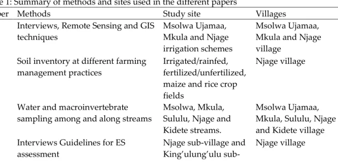
To study different aspects of land use change and management, including farmers’ perception as well as effects on soil and water quality and biodiversity, data collection involved both sociological and ecological methods (See Table 1 summary).
4.2.1 Interviews
In Paper I and IV, interviews were conducted following semi-structured questionnaires and focus groups discussions (FGD). Key informant interviews were also used for Paper I. To examine land use change and conservation potentials (Paper 1), historical information was collected in three irrigation schemes at Kilombero Valley: Msolwa Ujamaa, Mkula and Njage irrigation schemes by interviewing older farmers having enough information on the history and dynamics of agro-developments. Development of irrigation schemes and important farming improvement options were discussed and analysed through FGD.
Specifically, to assess perceptions of smallholder on rainfed and irrigation farming practices (Paper IV), the methods used by Nzau et al. (2018), Turner et al. (2000), and Sanogo et al. (2017)
were adopted and modified to fit the local context. This data was used for evaluating the supply-demand and mismatch of provisional, regulating and cultural services. Interviews were conducted at King’ulung’ulu (practicing rainfed farming) and Njage (practicing irrigation farming) involving 80 participants, 10 members for two FGD and 30 heads of households for questionnaire interview, for each farming practice, respectively. Participants were selected based to their experience of farming management and understanding of local agroecosystem transformation in the valley.
19
4.2.2 Mapping and spatial data
Remote sensing (RS) and Geographical Information System (GIS) techniques were used to map spatial and temporal changes at Msolwa Ujamaa, Mkula and Njage irrigation schemes (Paper I). The method involved use of Landsat satellites images (30 m resolution) from three different time-steps for the past 27 years: Landsat TM 5 for 1990, Landsat ETM+ for 2000, and Landsat OLI for 2017 of dry season, except for Njage where cloud free Landsat OLI for 2016 was used. The images were downloaded from the United States Geological Surveys (USGS) (https://www.usgs.gov/) pre-processed, followed by unsupervised classification and land use change detection using standard approaches (Batisani and Yarnal, 2009; Duda and Canty, 2010; Foody, 2002; Fuller et al., 1994; Huang and Jensen, 1997; Kashaigili et al., 2006) (for details see Paper I).
4.2.3 Biophysical and motoring data
Soil Sampling and analytical procedures
Field surveys of different farm management effects on soil nutrients (Paper II) were conducted during the dry season, after harvesting and before preparation of fields for the next farming season. Three major soil nutrients, carbon (C), nitrogen (N) and phosphorous (P) were selected, because they improve soil fertility and climate change mitigation through C sequestration. 38 fields were included in the study, covering all combinations of management and crop types. Four management practices were included: irrigated farming, rainfed farming, using fertilizer (both organic matter amendment and chemical fertilizer) and unfertilized, and the crops were maize and rice. Sample were collected in a vertical soil profile, including five layers: 0–20, 20–30, 30–40, 40–50, and 50–60 cm (c.f Jobbágy and Jackson, 2000; Wang et al., 2016) (for details see Paper II section 2.2).
Soil samples were air dried and sieved through a 2 mm sieve. The resulting fine fraction was used for particle size analysis (Klute et al., 1986), soil pH using supernatant suspension of 1:2.5 soil: 1 M KCl (Van Reeuwijk, 2002). Determination of soil carbon concentration, total nitrogen concentration and total phosphorous were following standard methods (see Paper II section 2.3 for details). Total SOC, TN and TP stocks were calculated by summing the contributions from all the sampled depths.
Water and macroinvertebrates– sampling and analytical procedures
Water quality and macroinvertebrate sampling was conducted in five streams with irrigation schemes (Paper III). Four streams (Msolwa, Mkula, Njage and Sululu) impacted by human activities were selected, while a fifth (Kidete) had minor human impact and was used as a control stream (Gerber and Gabriel, 2002; Reynoldson et al., 1995). Five sampling sites were located along each stream gradient: Site (1), located highest upstream within forest through Site (5) located lowest downstream where use of herbicides and chemical fertilizers as well as washing activities impacts are more common. For each sampling site, physical properties of water (conductivity, temperature, pH, dissolved oxygen (DO), and turbidity) were measured (three replicate measurements). Three replicate samples of benthic macroinvertebrates and water sample were collected from different microhabitats, at the same measuring point of the physical parameters (see paper III section 2.2 for details).
20
Water samples were analyzed for NO3−–N, NH4+–N, and PO43–P using standard
spectrophotometric methods described in American Public Health Association (APHA, 1998) Collected macroinvertebrates were identified to lowest taxonomic unit using the identification key (Gerber and Gabriel, 2002) and recorded on the TARISS version 1 score sheet (Paper III Appendix, Table A1).
Macroinvertebrates analyses for species richness, diversity and biological status were calculated using Margalef richness index (Margalef, 1958), Simpson’s diversity index (Simpson, 1949), and Average Score per Taxon (ASPT) index respectively (Dickens and Graham, 2002). ASPT expressed sensitivity score (TARISS score) per recorded taxon. Macroinvertebrate families were awarded TARISS scores based on their perceived sensitivity in the range of 1 to 15 (see details in Paper III section 2.3 and 2.4 for details)
Table 1: Summary of methods and sites used in the different papers
Paper Methods Study site Villages I Interviews, Remote Sensing and GIS
techniques
Msolwa Ujamaa, Mkula and Njage irrigation schemes
Msolwa Ujamaa, Mkula and Njage village
II Soil inventory at different farming management practices
Irrigated/rainfed, fertilized/unfertilized, maize and rice crop fields
Njage village
III Water and macroinvertebrate sampling among and along streams
Msolwa, Mkula, Sululu, Njage and Kidete streams.
Msolwa Ujamaa, Mkula, Sululu, Njage and Kidete village IV Interviews Guidelines for ES
assessment
Njage sub-village and King’ulung’ulu sub-village
Njage village
4.3 Data compilation and statistical analyses
Qualitative data obtained from the focal group discussions and household questionnaire surveys were analysed through content analysis (Paper I and IV). A likert scale of 1 (very low) to 5 (very high) was used for mapping value of services to identify supply and demand of ES and their contribution to livelihood (Paper IV). The distribution of frequencies and percentages of questionnaire were compiled and presented in tables and figures (Paper I and IV). Timeline analysis was used to present historical changes in irrigation schemes (Paper I). Descriptive statistics summarised concentrations of SOC, TN, TP, physical and chemical properties of water to means ± SE in Paper II and III.
A Chi squared test was used to determine whether there was a significant difference of ES demand and supply between rainfed and irrigated practices (Paper IV). In paper II, a general linear mixed effect model (GLMM) was used to test the effect of the farming management factors
21 irrigation/rainfed and fertilizers/non-fertilizers on SOC, TN and TP concentrations. An analysis of variance (ANOVA) was performed to examine changes on SOC, TN and TP concentration with depth. Pearson correlation coefficients were used to calculate correlations among SOC, TN, TP and the physical and chemical properties soils (for details see Paper II section 2.4). In paper III, Analysis of variance (ANOVA) and repeated measure ANOVA was use to examine differences among streams and sampling sites. Macroinvertebrate cluster analysis and MDS (multidimensional scaling) ordination were calculated using Bray-Curtis similarity index among sampling biotopes. Relationship among physical-chemical parameters and macroinvertebrate indices were analysed using Pearson correlation coefficient and conical correspondence analysis (CCA).
All statistical results were considered significant at p-values ≤ 0.05. Statistical analyses were performed using Excel (2016), and IBM SPSS Statistics (version 24) for Paper I, II, and III, IBM SPSS Statistics (version 26) for Paper IV, and PAST (Version 3.21) software for Paper III. Arc GIS 10.3 software were used for spatial analysis of remote sensing data of Paper I.
22
5. Results and discussion
The results from this thesis cover a broad perspective agricultural expansion and intensification with specific focus on how these effect (1) land use change along irrigation schemes; (2) soil nutrients and water quality, and (3) the management of ecosystems services (ES) in Kilombero Valley. Land use change, driven by anthropogenic activities, such as conversion of natural ecosystems to agroecosystems (Paper I), can have numerous adverse impacts on soil, water quality and ES. Degradation of soil quality and introduction of excess nutrients typically bring about accelerated erosion, eutrophication and contamination, sedimentation of reservoirs and waterways, emissions of greenhouse gases, and decline in macroinvertebrates (Paper II and III). Along with a more intensified food production to increase food security, conversion to more sustainable management practices must be considered in order to secure and ultimately strengthening numerous ES (Paper IV).
5.1 Key findings
Paper I
Migration, improvement of irrigation, transportation and market forces are important drivers behind land use changes manifested at both local and regional scales in Kilombero.
The predominant land use change in Kilombero has been forest, bushland and grassland being replaced by cultivated land. The local changes close to irrigation schemes have been transformed to a larger extent and at a higher rate compared to the remaining parts of the valley.
To secure ecosystem services in the valley, investment should be made to intensify small-scale irrigation farming, leaving the remaining part of the valley to recover from degradation.
Paper II
Irrigation and fertilization increase soil nutrient concentrations and the availability of SOC in the upper soil layer (0- 20 cm) in small to medium sized farms.
Moderate irrigation and fertilization can help to improve carbon storage and nutrient availability (for TN) in soils associated with small-scale farming.
Paper III
Water physical-chemical parameters and the composition of macroinvertebrates species are correlated. Downstream from irrigation sites there are lower species richness and lower diversity of pollutant sensitive species. These sites also have higher turbidity, nitrate-N, and ammonium-N concentration, but lower dissolved oxygen compared to upstream sites.
Ecological species indicators can be a useful, inexpensive method (in terms of time and money) to assess and monitor water quality in a small-scale irrigation farming.