RESEARCH ON THE TECHNOLOGY FOR SAFE OPERATION
AND MANAGEMENT OF ALPINE COLD AND HIGH-ALTITUDE
HIGHWAY
Huang Yong1,2 Liu Tao1,2 Ye Junming 2 John Jesper Elsander 3
(1. Key Laboratory of Highway Engineering Technology in Arid & Desert region, Ministry of Transport, PRC, Urumqi, Xinjiang, 830000;
2. Xinjiang Institute of Transportation Sciences, Urumqi, Xinjiang, 830000 3. Swedish Transport Administration, 784 37 Borlange, Sweden) ABSTRACT
This article describes and analyzes the road condition for a high altitude alpine road and the measures taken to ensure traffic safety and accessibility even in extreme weather conditions. It also in-depth analyzes the influence of various technical engineering management measures and their influence on the road safety. The article serves as a foundation for future design and management of roads in these kinds of extreme conditions.
Key words: Alpine cold; High altitude; Road safety; operation management
1 INTRODUCTION
The operation and management of roads in cold and high altitude areas has its unique characteristics. Based on engineering practice of Xinjiang Section of Xinjiang-Tibet National Highway 219, this article make in-depth analysis to the operating characteristics of the road in the terms of driver condition, road alignment features, climatic and geological conditions. Appropriate measures to promote road safety are proposes given the local conditions.
2 DEFINITION AND CHARACTERISTICS OF ALPINE COLD AND
HIGH-ALTITUDE AREAS
Traditionally, alpine cold and high-altitude areas are ones whose average altitude is over 4000m, and average temperature is below 0 degrees Celsius. Due to the extreme conditions, the highways in these areas have lower grade and often poor conditions, and not seldom have to be closed for traffic during extensive periods of time.
On the plateau of alpine cold and high-altitude areas, the road has less curves and large radius; in most sections, the road is straight and flat, which could make drivers lose their safety vigilance and be more likely to be involved in traffic accidents.
3 ROAD AND ROAD USER CHARACTERISTICS IN ALPINE COLD
AND HIGH-ALTITUDE AREAS
3.1 DRIVER'S PHYSIOLOGICAL CHARACTERISTICS
At high altitude the oxygen content in air is lower than what is at sea level. This means that drivers using roads in high altitude areas will be suffering from the symptoms (hypoxia) on the human body caused by the lower oxygen content. These symptoms include that heart- and respiratory rate will become significantly faster, headache, dizziness, fatigue, drowsiness, trance, unresponsiveness, lack of concentration and negatively effected ability to complete actions. These symptoms can seriously influence the driver's normal driving. In severe cases of hypoxia the driver will faint or lose consciousness.
3.2 CHARACTERISTICS OF THE ROAD ALIGNMENT
3.2.1 PLANE
In the plateau region, the terrain is generally relatively flat, especially in the Daban area, long straight sections of road occur frequently. When driving on these sections in high speed, if the surrounding landscape is monotonous, it can easily lead to driver’s fatigue. The result could be that the driver will have difficult in determining the speed and the distance between vehicles, and thus increasing the risk of accidents.
Especially in the ultra-long straight section connecting with large radius curve section without proper cross-fall, the driver is easily careless; due to over speed and lack of proper cross-fall, drivers cannot resist the centrifugal force and the deviate from the driving direction, rushing down the embankment, causing an accident.
3.2.2 VERTICAL SECTION
Alpine cold and high-altitude areas tend to be higher in one direction along Daban, resulting in a long descent section. The maximum vertical gradient and slope length in the Chinese specification only consider the uphill dynamic performance of vehicles, with no consideration of the road safety aspects of continuous downhill sections. In continuous downhill road sections, vehicles brakes easily get over heated, which in turn can lead to poor braking performance or even to braking failure, causing accidents.
3.3 CLIMATIC CONDITIONS
The climate in alpine cold and high-altitude areas is very dry, large annual and daily temperature differences, rare precipitation and large evaporation. For example, along National Highway 219, the average annual precipitation is 20-100mm, the average annual evaporation is 2400-2700mm, and the annual average temperature is below 0 degrees Celsius, the annual maximum freezing depth is about 180cm, and the maximum wind speed 26m /s. At the mountainous areas of an altitude of over 4800m, precipitation
is mainly in solid state, forming a large area of permanent snow and glaciers in the Kunlun Mountains. The climate conditions can easily cause severe traffic safety hazards.
3.4 GEOLOGICAL CONDITIONS
Alpine cold and high-altitude areas have complex geological conditions, undulating terrain. Along the road, water damages, mud-rock flow, collapse, permafrost, roadbed subsidence, frost boiling, snow damage and flowing ice and other special geological conditions are frequent. Harsh geological condition is the main obstacle that affects the normal and safe operation of the road, therefore it is necessary to minimize the occurrence of geological hazards along the highway.
4 SECURITY MEASURES TAKEN
4.1 THE DRIVER
In alpine cold and high altitude areas, the road has long term of freezing, road surface is ice slippery, the driver is under great pressure, blood oxygen content is decreased, and the response delay time is longer. It is necessary to ensure traffic safety and driving comfort from the driver’s visual and physiological responses. It is necessary to record the changes of driver’s blood oxygen concentrations, heart rate, respiratory rate under different altitudes, and establish the driver's psychological health and establish a accident database that has altitude as a parameter. Through qualitative and quantitative analysis highway alignment design specifications in highlands can be proposed based on the accident database.
4.2 ROAD ALIGNMENT
4.2.1 LONG STRAIGHT ROAD SECTION
In order to prevent the driver’s fatigue and overspeed driving due to environmental monotony and altitude sickness, it is proposed to set up warning notices for very long straight road sections, to increase public signs along the route, repeat the speed limit, put up warning notices for small radius curves etc to enhance security according to different linear combinations. From the distribution of G219 long straight line connecting radius curve, it can be seen that there are four distinct ranges: <200m, 250-450m, 450-900m, > 900m. If only considering the curve below the 250m to set up safeguard and only connecting long straight line with 23% curves, the improvement is not large. According to the relationship between plane curve radius and accidents, when plane curve radius is less than 450m, the curve steepens, the number of accidents increase dramatically. So it is proposed to make curve radius less than 250m and below 450m as the cut-off point for the enhanced security[10].
For longer than 1.6km straight line, it is recommended to set the starting line length notice signs and warning signs for noticing the vehicle distance. As the G219 highway starting line segment is too long and the first 6km section is in city, the noticing signs within 6 km line length are set up in the forward direction of the road and backward direction of K12+974 to inform drivers of the length range of the line, so as to be alert to prevent the driver's fatigue causing traffic accidents, notice signs shown in Figure 1
Fig.1 Long line notice sign
4.2.2 CONTINUOUS DOWNHILL
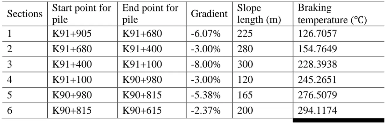
In continuous downhill section, brake failure due to high temperature of drum brake can occur, causing traffic accidents. For G219 highway, as an example, regarding 290 ℃ as the failure control temperature of vehicle brake drum, it is calculated that there are totally 80 places in 12 long continuous downhill segments where the temperature of brake drum approaches or exceeds the control temperature, therefore, there is the risk of brake failure. The brake temperature measurement of some road sections is shown in Table 1. All the continuous descent sections are located in or cross the Daban area where the road side space is often limited due to terrain conditions, so in some sections that have the risk of brake failure there is no possibility to set up emergency escape ramps. Therefore, it is proposed that it is necessary to set up the bay-type emergency parking area in the upper reaches of the continuous long downhill section. In the key hazardous road sections, emergency escape ramp can be set up.
Table 1 Braking temperature measurement in part sections of G219 highway
Sections Start point for pile
End point for
pile Gradient Slope length (m) Braking temperature (℃) 1 K91+905 K91+680 -6.07% 225 126.7057 2 K91+680 K91+400 -3.00% 280 154.7649 3 K91+400 K91+100 -8.00% 300 228.3938 4 K91+100 K90+980 -3.00% 120 245.2651 5 K90+980 K90+815 -5.38% 165 276.5079 6 K90+815 K90+615 -2.37% 200 294.1174
The emergency escape ramp can consume the kinetic energy to reduce the speed till vehicle stops through the friction between tire and aggregate, but the emergency escape ramp needs more space and cannot set up in some road sections climbing the Daban. Therefore, in the place where emergency escape ramp is needed but there is not enough space, It is proposed to strengthen the guardrail grade, even to improve it to A-grade; through scratching and buffering between accidental vehicle and guardrail, the speed-reduction purposes can also be achieved.
Warning signs of a continuous downhill section should not be too simple, it is not enough to only indicate that the front is a continuous downhill section, the signs should give the information such as the length and the average gradient etc, which will make warning signs work better.
Through investigating the driving behavior in continuous downhill sections, it is found that if the gradient difference between two adjacent longitudinal slopes is too large ith will easily cause the driver to produce an illusion: firstly downhill then uphill, so that the driver will be careless and let the vehicle coast, with out control of the speed, increasing the risk of brake failure; therefore in a continuous downhill sections, it is necessary to add a long downhill indication signs every 3-4km of gentle slope, set up length and speed limit warning signs of a long downhill slope, every 10km, at the near gentle slope 2-3 km near the bottom, set up the remaining xx km long downhill speed limits signs to alert drivers that the vehicle is still in the long downhill section. Sign examples of continuous downhill sections are shown in Table 2.
Table 2 Sign examples of continuous downhill sections
Location Slope top Gentle slope In the slope Gentle slope Signs
4.3 PREVENTION AND CONTROL MEASURES OF GEOLOGICAL
DISASTERS
4.3.1 COLLAPSE, DEBRIS FALLING
Influenced by terrain conditions in alpine cold and high altitude areas, geological hazards are frequent along the highway, the prevention and control measures mainly include two categories: active and passive protection technologies. The former is to anchor, support a single dangerous rock to prevent rock-fall, and to set up protective
fences; while the latter control concept is to effectively intercept after rockfall occurred, causing no harmful results.
4.3.2 DEBRIS FLOW
Making G219 Xinjiang-Tibet Highway as an example, through analyzing the specific characteristics of mud-rock flow problems along G219 highway Xinjiang section, combined with experiences and lessons for treating debris flow in the roads of other regions, the following control measures can be taken:
(1) overflow pavement: For the middle and small debris flow gullies which outbreak frequently, have stable trench, and has often water flow, when drainage and blocking engineering measures can not be implemented, we can concrete overflow pavement or set up boxculvert on the overflow pavement, making debris to flow and accumulate on the road till it stops, then removing the debris flow deposits and restoring the road traffic;
(2) Crossing works: to build bridges, culverts across the debris flow gullies, make the road ride over the debris flow gullies and debris flow pass through under bridges and culverts, so that the debris flow can be discharged outside the embankment. Bridges and culverts should be built in a starting end and fan ground where the gullies are deep; while diversion and revetment works should be made to control the pattern and potential of the debris flow;
(3) Blocking works: for the middle and small debris flow gullies in intense activity, to build one or more blocking dam at the start end or in the gullies to block solids in debris flow, reduce the peak value of debris flow to stop it and deposit or back-silt in the channel bed, so as to reduce longitudinal slope of channel bed, broaden channel bed, thus reducing the damage of debris flow to the downstream of road, but also stabilizing the adverse geological body to prevent the bank slope slumping;
(4) Channel-fixing works: to build the submerged dam and check dam in gullies to fix the loose deposits, and at the same time, to build the footwall in the part places of gully slope toe to reduce the lateral erosion of gully banks, so as to prevent channel bed cutting down and lateral erosion of gully banks, which maybe make material in channel bed to change into a source of debris flow;
(5) Drainage works: mainly use diversion dam and drainage canal to control the
potential of debris flow, discharge all the debris flow into the river outside the highway embankment, reducing the damage caused by debris flow to the highway;
(6) Silt field works: for debris flow with wide river channel, build the diversion and diversion dike in areas where conditions permit in the trench or channel start end to drain the debris flow into the trench or flat, wide, low-lying areas, make coarse particles in the debris flow to stop and accumulate in the road at the top to for a silt field, and then discharge fine particles and clear water outside the embankment.
4.3.3 FROZEN SOIL DISTRESS AND PREVENTIVE MEASURES
Distresses caused by frozen soil is common for extremely cold and high altitude localities. Weak subgrades due to partial thawing is frequent in the area and can cause dangerous road conditions, in order to decrease the hazard degree, the following control measures can be adopted:
(1) Realignment: for mountain crossing sections of the Kekeate Daban and Boundary Mountain Daban along the highway and the serious distressed sections of the north side of the Qitai Daban, a sweet water lake, the No.635 highway maintenance squad and broad valley, and the lake basin center, the realignment to avoid and detour shall be taken into account, to make the highway pass through the zones with the perpetually frozen soil being relatively stable and the drainage condition being good, such as the gentle slope, river terrace, and alluvial-proluvial fan border etc., to relieve the impact of the frozen soil environment to the line;
(2) To raise the subgrade, and arrange thermal insulation berm: the subgrade being low along the line is the main cause for the salivary flow ice and the subgrade thaw subsidence. Combining the past project experiences, it is recommended to raise up the subgrade depth of fill to above the critical perpetually frozen soil depth, and arrange thermal insulation measures of thermal insulation berm, rubble subgrade, and protective revetment etc. outside the side slope of the subgrade, to decrease the impact and damage of the frozen soil environment to the highway engineering to the utmost extent. For partial serious distress sections of the highway, it can adopt the manual freezing hot pin technique, EPS heat insulating material and manual geotextile to increase the cold energy storage, to prevent the perpetually frozen soil layer from warming-up and the underground ice from melting;
(3) To enhance the subgrade strength and perfect the water interception and drainage system: for partial serious mudding highway sections, it shall clear away the soft strata of silty soil and sand clay etc., replace them with gravel material which has good water stability, mix in with ashes, change subgrade filler, and enhance the subgrade strength. To arrange waterproof and thermal insulation berm at both sides of the subgrade, arrange drain ditch, water interception and weeper drains, it is to lead the accumulated water to be drained to the outside of the affected subgrade zone. At the same time, it shall add water drainage structures of bridges and culverts etc., and arrange ice-retaining wall or ice accumulation pit, to prevent the waterflow and salivary flow ice from overtopping the road;
(4)To arrange the necessary gravel pits and dumping sites in a organized manner: during the construction, special concerns should be taken to minimized the impact of the gravel pits, work sheds, and construction of temporary roads, to the perpetually frozen soil environment. The gravel pits shall be arranged in proluvial fans, river beach, or river terrace which are far from the highway, have few frozen earth, and are sparsely
vegetated, it is strictly prohibited to take out gravel by the road side and open earth pits at discretion, and it shall avoid to take out gravel from rich frozen soil zones. After finished using the gravel pit, it shall be back filled as soon as possible and restored to the original condition as well as possible, avoiding damaging the frozen soil environment.
4.4 IMPLEMENTATION OF EMERGENCY PREPARATIVE PLANS
The emergency preparative plans for the extremely cold and high altitude localities are mainly against the occurrence of catastrophic floods and sudden snow disasters. In order to prevent the impact of these two kinds of disasters to the road normal operation, it is recommended to adopt the following measures to make prevention and control: ① to strengthen the information monitoring and early warning, to give warning in the areas where it can occur rainstorm and snowstorm; ② to verify through investigation immediately the disaster condition of the areas and report in time, and quickly prepare and organize to save the major material and property; ③ in normal condition, the road construction and maintenance division and the construction enterprise shall guarantee the funds, goods and materials, and equipment of the emergency service team. The emergency service team shall carry out necessary emergency evacuation drills to enhance the emergency capability.
5 CONCLUSIONS
This thesis analyze the safe operation of cold alpine and high-altitude areas from 4 aspects: driver, weather conditions, road alignment and geological conditions, and put forward a variety of control measures. This paper has G219 Xinjiang-Tibet Highway as an example, and the proposed control measures have targeted G219's unique characteristics. Different alpine cold and high-altitude areas have their own characteristics so it is necessary to take local conditions and characteristics in to account to find the specific control measures for a specific road. In addition, road safety control and road safety management and other security measures should be better combined so that a better result can be achieved.
REFERENCES
[1]Wang Zhong. Discussion on the highway traffic safety measures in fog [J]. Highway & Automobile Applications, 1997, 2(2)
[2] Zhao Gengqi. Ventilation Technology for Long and Large Tunnels at Extremely Cold Areas of Qingzang Plateau [J], Railway Standard Design, 2007, (01).
[3] Wu Chugang. Anti-freezing Technology of Highway Tunnel in Xinjiang Tianshan Area [D], Chongqing Jiaotong University 2010.
[4]Cheng Guodong. Some permafrost differences between China’s Qingzang plateau and the north of Canada [J] Journal of Glaciology and Geocryology, 1979, (02).
[5] Wang Jian. The Situation of Snow Removing Machines and Its Development Trends [J] Journal of Hulunbeier University, 2005, (02).
[6]Wang Zhen. Personal Opinions on Present Situation of Domestic Snow and Ice Removing Machinery [J] Construction Machinery and Equipment,2002, (07).
[7] Deng Hongchao, Ma Wenxing, Jing Baode. Technology of Removing Snow and Ice on Roads and Its Developing Trend [J] Construction Machinery and Equipment, 2005, (12).
[8] Jiang Bin. Thoughts, Methods and Management of Road Removing in Developed Countries[J]Road Machinery & Construction Mechanization ,2006,(11).
[9]American Association of State and Highway Transportation Office Highway Safety Design and Runing Guide [M].3rd Edition.Washiongton,D.C: AASHTO, 1997.
[10] Zhao Guanghai, Wang Min. Highway horizontal curve design and traffic safety [J], Traffic standardization, 2010, (226) .