Urban Studies
Master’s Thesis (Two-year master) 30 credits
Spring 2017
Supervisor: Guy Baeten
In the surge of healing?
The case of Indus Basin
Acknowledgement
The portrayal of water security-scarcity nexus could not be possible without the help of work from Mustafa. Weaving the real and ideal world this dissertation greatly benefited from the comments provided by Carina Listerborn and Maria Persdotter during the thought process.
The critical analysis of case studies has been enriched with data and evidence provided by Muhammad Javed and Kashif Javed since the beginning. They also helped in organizing the interviews from professionals which proved an immense assistance. An insight of the official documents has also been provided by Ayesha Shoib which motivated the methods of analyzing the whole phenomenon.
This paper would be hardly possible without the moral support of my parents Misbah Abid and Abid Ghafoor.
List of Selected Abbreviations
AK Azad KashmirBBC British Broadcasting Corporation CM Cubic Meters
CPEC China Pakistan Economic Corridor FAO Food and Agriculture Organisation GDP Gross Domestic Product
HKH Hindu Kush Himalayan IBIS Indus Basin Irrigation System IRS Indus River System
IRSA Indus River System Authority
IWRM Integrated water resources management IWT Indus Waters Treaty
J&K Jammu and Kashmir LoC Line of Cntrol
LDA Lahore Development Authority MCM Million Cubic Meters
MR Marala Ravi
SCARPs Salinity Control and Reclamation Projects UIB Upper Indus Basin
UNEP United Nations Environment Programme UNSC United Nations Security Council
USSR Union of Soviet Socialist Republics WAPDA Water and Power Development Authority WB World Bank
Table of Contents
Summary ... 1
Chapter 1: Introduction ... 2
1.1 The Puzzle ... 3
1.2 Water Security in South Asia... 4
1.3 Research Aims and Questions ... 7
1.4 Importance of Research ... 7
1.5 Layout ... 8
Chapter 2: Background ... 9
2.1 History and Demography of Indus Basin ... 9
2.1.1 Geography of the Region and Distribution of Water Resources ... 9
2.1.2 Demographic Characteristics ... 10
2.2 Why the Water Resources of the Indus Basin Are Important to the Co-riparian States ... 11
2.2.1 Irrigation Waters ... 11
2.2.2 Hydroelectric Power ... 12
2.3 The Kashmir Dispute ... 14
2.4 Importance of Indus Basin in the World ... 16
Chapter 3: Methodology and Research Approach ... 18
3.1 Methodology Overview ... 18
3.2 Method of Data Collection ... 18
3.3 Method of Data Analysis ... 19
3.3.1 Applying Case Studies ... 19
3.3.2 Choice of Case Studies ... 19
3.4 Scope and Limitations ... 19
Chapter 4: Theories and concepts ... 21
4.1 Urban Political Ecology ... 21
4.2 Urban Political Ecology and Scale ... 22
4.3 Waterscapes and Political Ecology ... 23
Chapter 5: Presentation of Object of Study ... 24
5.1 Indus Basin ... 24
5.2 River Ravi... 25
6.1 Water as a Tool of Politics ... 29
6.2 Effects of Water Politics on the Urban Settlements ... 30
6.3 Landownership and Water Commodification ... 31
6.4 Surge of Healing? ... 33
Chapter 7: Discussion ... 35
Chapter 8: Conclusion ... 38
Bibliography ... 39
Appendix ... 45
Article XII of IWT ... 45
1
Summary
Water being a vital resource and an inevitable ingredient for the existence and sustenance of life drew the attention of human settlements from the beginning. Nearly all human activities i.e. commerce, sanitation and transportation get influenced by water in one way or the other. Since water resources are continuously depleting due to myriad problems, so water sharing is also becoming a conflicting point between nations. Although the debate of saving water draws its trajectory from 1980’s however, the link between water and security has emerged only in the post-Cold War scholarly debate about the scope of the security concept itself. To understand the concept of water security in the South Asian context the case study of Indus basin is chosen in this dissertation. Shared by four riparian states i.e. China, Pakistan, India and Afghanistan, the Indus basin serves as a trans-boundary water resource from ages. But unfortunately the Indus basin lies in a part of the world where intense distrust, chronic conflict, and bitterly contentious water policies have a long history too. Stagnant or decreasing agricultural productivity, increasing dependence on groundwater, growing population, high risk of climatic variability, enhancing industrialization, and unplanned and un-regularized urban growth are the major challenges which are gnawing the Indus basin. However the issue of water security and scarcity does not merely dependent on the absolute (or physical) availability of a natural resource. But water insecurity at the individual and regional scales is as much about political and social construction in this context. Drawing on insights from the interdisciplinary tradition of political ecology, here the issues pertaining to Indus basin are restricted to the realms of two riparian states only, i.e. India and Pakistan. Although the geographical setting of the Indus River system has facilitated the partitioning of the six rivers in equal numbers between the two riparian countries India and Pakistan under the 1960 Indus Water Treaty (IWT), nevertheless, there have been a number of acrimonious conflicts between India and Pakistan over Indian projects on these eastern rivers. This dissertation brings forth the perspective of political ecology rather than restricting the connection between water scarcity and water security in the Indus Basin through the lens of decline of physical water supply per capita. Rowing through the political ecology of water resources nourished by Indus basin, it culminates at the case study of Ravi riverfront development project. These case studies suffice the analysis of political ecology at macro and micro scale and portray the issue of water commodification in the South Asian context.
2
Chapter 1: Introduction
“Water is the true wealth in a dry land; without it, land is worthless or nearly so. And if you control water, you control the land that depends upon it” (Gleick, 1993).
Water is without doubt a critical resource for human survival, economic development, and ecological balance in nature. Hardly any other natural resource affects so many areas of human life, therefore scarcity of water, in particular, affects a broad spectrum of spheres, from health to human rights, the environment to the economy, prosperity to poverty, culture to politics, and conflict to war. Water can mean the difference between life and death. Moreover, water defies political boundaries therefore can be a potential cause of war. Water being the vital ingredient in human settlements is transforming into a withering resource. Traditionally, water has been an abundant resource for development, virtually amounting to a free good. However, the situation is now changing rapidly. A point has been reached where water scarcity has become a potential threat to national stability, regional peace, and international security. Experts are of the opinion that in the twenty-first century, wars will be waged for access to freshwater resources [rivers] and, as a consequence, will endanger international peace and security. The global mobilizations for ‘The Right to Water’, remain largely unexplored in terms of their origin, variegated impact and strategies (Sultana & Loftus, 2012). World Water Council reports that while the world’s population tripled during the 20th century, the use of water for human requirements multiplied six fold (World Water Council, u.d.). Although the debate of saving water draws its trajectory from 1980’s however, the link between water and security has emerged only in the post-Cold War scholarly debate about the scope of the security concept itself. Water sharing is the key environmental concern on the global scale and, up to a point, has been successfully handled politically. The increasing use of the term water security raises an important conceptual issue for water analysts and managers: how does water security overlap with Integrated Water Resource Management (IWRM) and to what extent are they complementary paradigms? This is particularly important given that IWRM has emerged as a dominant water management paradigm in the discursive framing of international water policy over the past 20 years (Cook & Bakker, 2012). Differential social power is a ubiquitous theme running through resource management in different geographical contexts; although it is impossible to separate these ‘concepts’ and practices from each other in the flow of water, it does not take much to identify the profound social, cultural, political, and ecological forces, struggles and power relations at work in this perpetual metabolizing circulation process of flowing water (Swyngedouw, 2004).
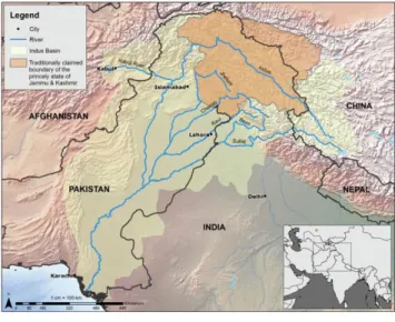
This thesis encompasses the issue of water sharing while highlighting the boundaries carved after the division of two rival countries i.e. India and Pakistan. Figure 1-1 shows the Indus River system which flows the four Co-riparian states.
Plunging into the synergies of geographies of natural resources and the power relations invading these resources, this research draws connections between the waterscapes and their travel through the borders. After grasping a holistic picture the research portrays how the history carved the boundaries of the rivers, and how India and Pakistan negotiated to have equal divisions, what are the major conflicts and current challenges while sharing the water resources? Juxtaposing with the scenarios of water security, the issue of optimizing the use of natural resources is highlighted.
3
Being brought up in the lap of city Lahore, which is the capital of Punjab (a neighbor of province AJK) the fluctuating water levels of River Ravi intrigued the author to investigate this topic and to envisage the future of the city in the times of water scarcity. Moreover while pondering over the word Punjab which means a land of five rivers, it occurred to me that the passage of time infused major changes to this land. A land which was named after its water resources is now entangled with water scarcity. A Pakistani newspaper reports that “with two dying rivers (River Ravi and River Sutlej), the land of five rivers is rapidly turning into a land of three rivers” (The News, 2015). It further emphasizes that the Environment Minister for Punjab Shuja Khanzada, and environmental experts Hamad Naqi Khan and Dr Kausar Abdullah Malik, also showed up grave concerns over the hazards faced by the River Ravi (ibid).
Nations have often fought to assert or resist control over natural resources such as oil, materials for warfare, sea lanes, farm lands, minerals and other vital assets. “Throughout human history, but particularly since the system of sovereign nation states struggles over access to and control over natural resources…have been a root-cause of tension and conflict” (Renner, et al., 1991). Hurst claims that "although there is considerable rivalry among nations over the possession of such things as oil, gas and uranium, the most dangerous rivalry between countries can be for the possession of water, one of the elements without which man cannot exist" (Hurst, 1956). Seeking the trajectory of interaction of power relations and natural resources the next section narrates the overview of how these two nations (India and Pakistan) addressed the issue of water sharing in the past and until today and what are the polemical concerns.
1.1 The Puzzle
Insight can be taken by analyzing the puzzle of commodification of water by studying trans-boundary water resource management. One such example of trans-boundary water resources is the Indus basin, which is being shared by four riparian i.e. India, China, Pakistan and Afghanistan, lurks in myriad number of challenges. Figure 1-2 shows the location of Indus river system and the water tributaries emerging from basin. India and Pakistan being the prime consumers of the Indus basin carves a history of conflict on the water resources. Nevertheless, both states agreed on a rivers diversion formula in the shape of the Indus Waters Treaty in 1960 which, however, did not lead to conflict-free, mutually peaceable working relations, even for a short period (Mirza, 2010). Above all, neither of the states relinquished their historical territorial claims over Kashmir, for example: Pakistan accepted the Indian demand for the permanent diversion of three out of the system’s six rivers in 1960, and India apparently agreed not to interfere with the flow of rivers in Jammu and Kashmir under its administrative control but why both never compromised on the issue of Jammu and Kashmir territory, provides the starting point in this research. Both states remain uncomfortable with the Treaty. In May 2002, the Indian government considered abrogation of the Treaty, ‘to teach Pakistan a lesson’— a fact then widely published in Indian newspapers (The Asian Age, 2002). Concerns have been openly expressed in Pakistan that “it was the military regime of General Ayub Khan, which surrendered to Indian blackmail and World Bank and US pressures to sign away every drop of three of the five tributaries of the Indus [river system] to India” (Bengali & Gazdar, 2001). According to historical usage, as designated by international law, “India was entitled to 8 per cent of the water of the Indus river system. Instead, the Indus Basin Treaty of 1960 allocated 20 per cent to it” (ibid). On 27th July 2004, Pakistan’s legislators moved a motion in the National Assembly urging the government to include Indus waters’ sharing issue in the ongoing peace
4
process [composite dialogue] and immediately consider buying water from India to tide over acute water shortages and renegotiation of the 1960 Indus Water[s] Treaty between the two countries to get more water from the Sutlej river. Speaking on a point of order, a parliamentarian remarked that “the Indus Waters Treaty was perhaps the only pact on the earth in which a ‘nature resource’ was ‘sold out’” (World Water Council, u.d.). A comprehensive account of background knowledge has been provided in the coming section through which portrays the situation of Indus basin in detail.
Figure 1-2 Indus River system
To date both nations are struggling, according to scholars an increase in water stress in the basin states since the early 90s has brought the treaty under strain. Amin asserts the survival of IWT appears weak, ‘although there is no exit clause’. The treaty fails to address two issues: the division of shortages in dry years between India and Pakistan, when flows are almost half as compared to wet years, and the cumulative impact of storages on the flows of the River Chenab into Pakistan (Ahmed, 2017).
1.2 Water Security in South Asia
To understand the concept of water security in the South Asian context it is highly essential to incorporate the existing statistics related to water stress in South Asian context. Furthermore this section narrows down the scope by focusing on the trans-boundary water sharing between India and Pakistan.
Water security is defined as the capacity of a population to safeguard sustainable access to adequate quantities of acceptable quality water for sustaining livelihoods, human well-being, and socio-economic development, for ensuring protection against water-borne pollution and water-related disasters, and for preserving ecosystems in a climate of peace and political stability (UN-Water, 2013). Water security encapsulates complex and interconnected challenges and highlights water’s centrality for achieving a larger sense of security, sustainability, development and human well-being. Many factors contribute to water security, ranging from biophysical to infrastructural, institutional, political, social and financial – many of which lie outside the water realm. In this respect, water security lies at the center of many security areas, each of which is intricately linked to water. Addressing this goal therefore requires
5
interdisciplinary collaboration across sectors, communities and political borders, so that the competition or potential conflicts can be solved (ibid).
Water stress is defined as a stress that occurs when the demand for water exceeds the available amount during a certain period or when poor quality restricts its use. Water stress causes deterioration of fresh water resources in terms of quantity (aquifer over-exploitation, dry rivers, etc.) and quality (eutrophication, organic matter pollution, saline intrusion, etc.) (European Environment Agency, u.d.). According to Daanish Mustafa, Security in the South-Asian context refers to national security, in terms of direct conflict and violence between different groups and users, and to human security, defined as an individual’s security from environmental extremes and social instability. He further asserts that water is the material basis of existence, livelihoods, and production, and lack of access adversely affects not only human security but also social stability. Human security and social instability typically manifest themselves at the subnational scale (Mustafa, et al., 2013).
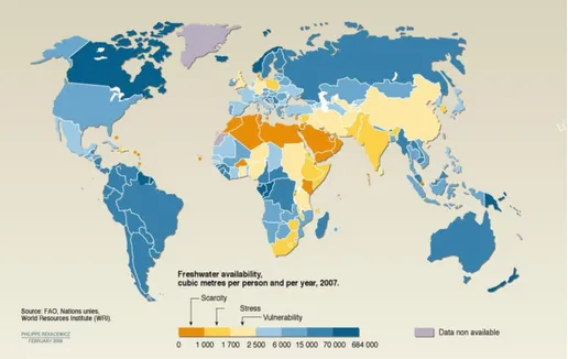
With limited land resources, inadequate energy supply, and growing water stress, South Asia faces the challenge of providing enough water and energy to grow enough food for the burgeoning population (Rasul, 2014). The water scarcity is also shown in the Figure 1-3. Food and water are essential for human existence and energy is the key to human development. But access to these resources and their sustainable management are the basis for sustainable development. Recognizing that efficient use of these limited or declining resources is essential to sustainability, the global community has turned its attention to the concept of the food, water, and energy nexus. Rasul emphasizes that with just 3% of the world’s land, South Asia has about one-fourth of the world’s population (1.6 billion people). Rice and wheat, the staple foods in the sub region, require huge amounts of water and energy. Freshwater, once abundant, is under growing stress due to the increased demand for competing uses, and climate change is creating additional uncertainties (Eriksson, et al., 2009). About 20% of the population of South Asia lacks access to safe drinking water (Babel & Wahid, 2008). The increase in water stress and water demand raises questions about how to ensure enough water for growing food without losing hydro-power for energy security. The energy required to make water available for crop production, for example through ground-water pumping, is in serious shortage (Shah, 2009); per capita energy consumption in this region is among the lowest in the world, only 300 kg of oil equivalent, which is just one-third of China’s 2001 per capita consumption (Rasul, 2014). With a large and rising population, limited land resources, inadequate energy supply, and growing water stress, South Asian countries face a common challenge of how to produce more food with the same or less land, less water, and increased energy prices. However in this dissertation only the element of water is being conferred and the trans-boundary water resource between India and Pakistan i.e. the Indus basin is highlighted.
6
Figure 1-3: Water scarcity (Source: Vital Water Graphics, UNEP)
Pakistan and India share a 1610 km long border which also bridges six watercourses i.e. the Indus, Jhelum, Chenab, Ravi, Sutlej and Beas, along with their numerous tributaries. Pakistan, like many other countries of the region depends heavily on agriculture, with the greater part of the population relying on it for livelihood. As a result, water is not only vital for everyday needs, but a critical source for economic development. Pakistan and India being close neighbors in South East of Asia, gained independence in 1947 from British Government. Rice and wheat are the staple foods in South Asia; about 50% of dietary energy comes from these two crops. But these crops require huge amounts of water – about 1000 tons to produce 1 ton of grain (Brown, 2009). Their production depends on the availability of water in the dry season and on irrigation facilities, which depend on water from the Hindu Kush and Himalayas. These mountains are the source of Asia’s 10 largest rivers including the Brahmaputra, Ganges, Indus, Mekong, Yangtze, and Yellow Rivers, which are a lifeline for more than a billion people, almost half of humanity (Rasul, 2014). Rasul further connotes these rivers and their numerous tributaries are the main sources of freshwater in South Asia. They provide water for drinking, irrigation, fisheries, navigation, and hydropower and support terrestrial and aquatic ecosystems.
In West Asia, negotiations on sharing water resources have always been hostage to the volatile political situation (Sinha, 2005). Sinha further emphasizes that a successful negotiation on water, which is highly emotive and divisive, requires relative regional stability and strong leadership to conclude a deal. Water security in India requires two-fold analysis. From earlier observations, it is clear that for India water security is less of inter-state problem. The evaluation, therefore, requires an intra-state perspective (within). In India, quantitative supply problems are increasing. India will enter the ‘stress zone’ by 2025. Water scarcity due to ground water depletion is already a major problem (Ibid). In the similar vein, over the last decade, Pakistan became a water-stressed country. The United Nations (UN) currently estimates an annual per capita availability of 1,090 cubic meters (UNPD). The UN’s Food and Agriculture Organization (FAO) measures the pressure on national water resources by calculating water withdrawal as a percentage of total renewable water resources (TRWR). Stresses are considered high if the TRWR value is above 25 percent. Pakistan’s water pressure amounts to a staggering 74 percent. This pressure
7
is exorbitant even compared with neighboring high-pressured countries, including India at 34 percent and Afghanistan at 31 percent (AQUASTAT, 2016).
1.3 Research Aims and Questions
This thesis begins from the premise that it is overly simplistic to understand physical scarcity, measured as per capita freshwater availability, as a major cause of water insecurity. We understand discourses that assert a direct causal relationship between physical scarcity and social crisis as part of the ideological mystification of the highly unequal social distribution of ecological goods like (Akhter, 2016). By ignoring the uneven power relations within society, these post Malthusian narratives disproportionately blame marginalized social groups for increasing physical scarcity, even as these same groups are in fact the most vulnerable to rapid environmental change (Mehta, 2010). Instead of attributing a causal efficacy to physical scarcity (too little water or too many people), a political ecological perspective understands historical change as process characterized by a complex and dynamic interaction between social and ecological forces (Akhter, 2016). Scarcity from a political ecology perspective is not absolute and nature-given, but socially produced (Cook & Bakker, 2012). A major insight of political ecology concerns the ways in which the specter of scarcity and its framing as a natural phenomenon are discursively employed to serve the interests of the elites who profit from the social processes that produce this scarcity, often in the name of solving it (Kaika, 2005). Framed as a collective, natural problem, scarcity galvanizes support for those in power and depoliticizes choice (Nevarez, 1996); (Swyngedouw, 2004). This dissertation highlights and analyses the construction of socio political processes of water and security revolving around Indus basin while rejecting the argument that absolute population growth is responsible for absolute resource scarcity. This dissertation argues instead that environmental degradation, resource scarcity, and resource security are all socially constructed— normative and collective understandings that have consequences for physical and social worlds like Mustafa 2011. The linchpin of this dissertation is to explore the disguised surge of healing in the public and private interventions of accumulating capital through commandeering water resources at the national and state level.
Problem statement: “Identifying the political ecology around the waterscapes of different scales.” Following are the research questions which help in diagnosis of the problem statement:
How water is used as a tool of politics in Indus basin?
How commodification of water is connected to both waterscapes at national and local scale?
Effects of water politics on the urban settlements?
How a riverfront project development is nested with water commodification?
1.4 Importance of Research
Water landscapes are becoming a conflicting point for countries especially who are sharing Trans-boundary water resources. Since the trend of urbanization is bringing a tide of diverse challenges for the urban realm, one of the major problems is the access and equity of the water resources. The interlinking nature of water with every genre of life makes it a more crucial issue. The impacts of water discourse
8
are so deep for the urban realm so a lot of research has been dedicated to this arena. It is safe to state that investment in water security is a long-term pay-off for human development and economic growth, with immediate visible short-term gains (UN-Water, 2013). The semi-arid environment of the Indus Basin is home to more than a quarter of a billion people with some of the lowest human development indicators in the world (Mustafa, 2013). The bustling ancient cultures of northwestern South Asia and present-day Pakistan and northwestern India can be called a gift of the Indus. Given the stakes involved, in terms of the survival of millions of people, the Indus River Basin has been a veritable laboratory for international and national research on various problems with water distribution, development, and management, especially as they pertain to issues of water efficiency, equity, hazards, and environmental quality (Wescoat, et al., 2000). About the towering importance of the basin’s waters in the lives of its inhabitants, there is now a huge and growing literature (Adeel & G.Wirsing, 2017). Following these themes the concept of water security has been analyzed in this dissertation. Furthermore the notion of healing and optimizing the natural resource is brought forth which is rarely discussed. This dissertation explicitly reveals the importance of cooperation while sharing water resources and surmounts the factors of non-cooperation by providing some useful suggestions.
1.5 Layout
This dissertation addresses the scalar construction of socio natural processes and the centrality of a politics of scale in the production of particular geographical configurations and the problematic will be approached from historical-geographical materialistic perspective like (Swyngedouw, 2004). There are four sections. In first section I examine the question of security of water in the South Asian context. Along with comprehensive background knowledge pertaining to the Indus basin, the overview of challenges of past and present are also described in this section. In the second section two examples of contested construction of spatial scales, in which the politics and the commodification of natural resource (water) operates in inseparably intertwined manners, are presented i.e. Indus basin and River Ravi upfront project. The struggle of commodifying water between the riparian countries is shown. The third section loiters in the analysis of the intertwined relationship of politics of scale at a macro as well as micro level. The effects of water politics on urban settlements such as Kashmir and the site of river Ravi are provided to underpin how the public and private authorities commodify the waterscapes, which go hand in hand with the emergence of the lucrative business of housing for rich urbanites while ignoring the existing urban issues.The notion of finding the surge of healing for the highly stressed Indus basin on larger scale and the dying River Ravi on the smaller scale has been probed through the instrument of capital accumulation. The final section culminates with the discussion of importance depoliticizing the issue of water and infers the regional benefits of sharing the natural resources.
9
Chapter 2: Background
The Indus basin lies in a part of the world where intense distrust, chronic conflict, and bitterly contentious water policies have a long history (Adeel & G.Wirsing, 2017). Despite uncertainty surrounding how quickly water resources are being depleted and what future populations and industries may need, it is clear that Indus basin water is precarious (Mustafa, et al., 2013). In the following section a comprehensive background is provided to understand the complexity of the context. Important geographical and demographical factors are highlighted. Moreover to infer the intricate nature of the issues pertaining to water the interest of co-riparian states are briefly described.
2.1 History and Demography of Indus Basin
2.1.1 Geography of the Region and Distribution of Water Resources
The total area of the basin is approximately 1.12 million square km, ranking it about 21st in size among all the world’s river drainage or catchment areas. It embraces a whopping 65% of Pakistan’s total area, with what remains of the basin divided disproportionately among India (14%), Afghanistan (11%), and China (1%). As for each country’s share of the basin’s territorial extent, the division is only a bit more even, with Pakistan commanding 47%, India 39%, China 8%, and Afghanistan 6% (Adeel & G.Wirsing, 2017). The total water withdrawal in the basin is estimated at 299 cubic km, irrigation withdrawal amounting to 93% of that, with Pakistan accounting for about 63%, India for 36%, Afghanistan for 1%, and China for a meager 0.04% (AQUASTAT, 2011). The ‘uneven landscapes of power’ we see here – and its implications for each country’s stakes in the Indus system – naturally contributes to the political puzzles later dealt with in this report. The river Indus rises on the Tibetan Plateau and in its passage through Pakistan and India it drains through the highest mountain ranges of the world i.e. Hindu Kush Himaliyan (HKH). The Himalayan glaciers and snow sustain water flow in the Indus and rich minerals sediments from the mountains contribute to the fertility of the alluvial plains. A combined annual average volume of about 175 billion cubic meters (175 cubic kilometers or about 140 million acre feet) including all major tributaries is discharged into the Indus plains.
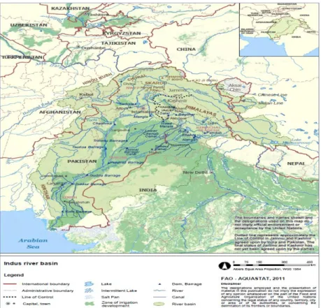
The basin extends over 1 million square kilometers with roughly 59% in Pakistan, 28% in India and the rest in Afghanistan, Tibet and China (ibid). The Indus mainstream, ranking 22nd in length (3180 kms/1976 miles) and 17th in discharge, stands among the world’s greatest rivers. Originating in China’s Tibetan Plateau, it is the axial branch of the Indus system of rivers that includes the flow of six major tributaries – one of them (the Sutlej), like the Indus itself, arising in China’s Tibetan Plateau, four of them (Ravi, Beas, Jhelum, and Chenab) arising in India, and a sixth (the Kabul) arising in Afghanistan (Adeel & G.Wirsing, 2017). Three of these rivers (Ravi, Beas, and Sutlej) are formally designated in the bilateral (India and Pakistan) 1960 Indus Waters Treaty as the Eastern rivers (their waters belonging to India), while the Jhelum and Chenab, along with the Indus mainstream, are designated as the Western rivers (belonging to Pakistan). Figure 2-1 shows the location of reservoirs and barrages constructed on the Indus river basin and its tributaries.
10
Figure 2-1: Location of reservoirs and barrages constructed on the Indus River and its tributaries (AQUASTAT, 2011)
2.1.2 Demographic Characteristics
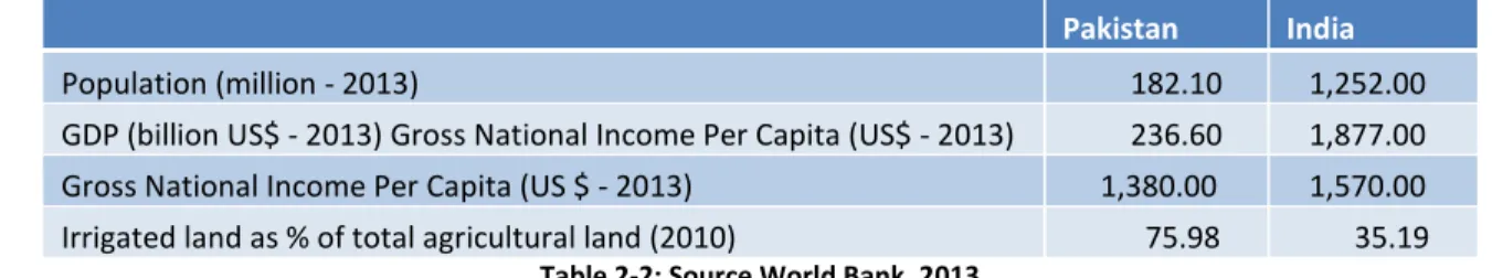
“Very roughly,” according to UN Food and Agriculture Organization AQUASTAT data, “at least 300 million people are estimated to live in the Indus basin” (AQUASTAT, 2011). The largest portion of this number (certainly over half), owing both to its disproportionately larger share of the basin’s territorial extent and also to the fact that nearly all of its major cities lie within the basin, belongs to Pakistan; but Afghanistan and especially India can also claim fairly hefty shares. Following Table 2-1 and Table 2-2is showing the riparian sharing the area in Indus basin in percentages which shows the power accumulation over natural resources in regards to demography and population and their incomes connected to irrigated land as percentage of total agriculture land.
Basin Name Area in sq. Km Countries Area of country in basin (sq. Km) Country percent area Indus 1138800 Pakistan 597,700 52.48 India 381,600 33.51 China 76,200 6.69 Afghanistan 72,100 6.33
Chinese control, claimed by India 9,600 0.84 Indian control, claimed by China 1,600 0.14
Nepal 10 -
Table 2-1: Riparian States in the Indus River Basin. Source: (ASIA: International River Basin register (updated August 2002) http://www.transboundarywaters.orst.edu/publications/register/tables/IRB_asia.html
11
Pakistan India
Population (million - 2013) 182.10 1,252.00 GDP (billion US$ - 2013) Gross National Income Per Capita (US$ - 2013) 236.60 1,877.00 Gross National Income Per Capita (US $ - 2013) 1,380.00 1,570.00 Irrigated land as % of total agricultural land (2010) 75.98 35.19
Table 2-2: Source World Bank, 2013
2.2 Why the Water Resources of the Indus Basin Are Important to the
Co-riparian States
The waters of the Indus basin are indeed the lifeblood of the basin’s inhabitants. The basin provides water for agricultural irrigation and industrial requirements, hydroelectric power and flood control, recharging of aquifers, and maintenance of wetlands and coastal zones, as well as for transportation, fisheries, and domestic human consumption. Here we elaborate on two of the more important ways in which the Indus waters impact the lives of the basin’s inhabitants – agricultural irrigation and hydroelectric power.
2.2.1 Irrigation Waters
The Indus system of rivers, which includes numerous smaller tributaries draining from the Hindu Kush, Karakoram, and Himalayan ranges, houses today on Pakistan’s side of the border the fifth largest irrigation system in the world (and the world’s largest contiguous irrigation system). Comprising what is called the Indus Basin Irrigation System (IBIS) as shown inFigure 2-1, this system consists of three large (1000 MW or more) hydropower dams (Mangla on the Jhelum, Tarbela on the Indus, and Ghazi Barotha also on the Indus), the first two of which, together with the Chashma Barrage on the lower Indus, are Pakistan’s only major storage dams; about 50 smaller dams (and many more under construction); 23 or so barrages and head works; and a mammoth network of 12 inter-river link canals, 45 irrigation canals, over 107,000 watercourses, and millions of small farm channels and field ditches – together comprising over a million miles of water conveyance (AQUASTAT, 2011).
Begun in 1849 during the British colonial era, the network the British built over the course of nearly a century before hauling down the Union Jack over British India was burdened neither with the territorial division of the 1947 Partition nor with the riverine division that arose from the 1960 Indus Waters Treaty. What they built was an integrated basin-wide irrigation system, about 90 % of it located in what would later become Pakistan and the rest in Indian Punjab – both an engineering marvel and, potentially, a model for trans-boundary cooperative development in the post-independence period (Adeel & G.Wirsing, 2017). Just such a model, grounded in the notion that the Indus system was a “natural” entity that needed to be retained as a “depoliticized space” following Partition, was famously – and unsuccessfully –urged upon India and Pakistan in 1951 by David Lilienthal, a prominent American water bureaucrat (Haines, 2014).
12
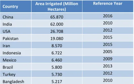
The critical role irrigation plays in Indus basin agriculture – and in the water and food security of the people living in and around the basin – can hardly be exaggerated. By far the greatest concentration of the world’s irrigated land – close to 65 % of it – is in Asia, about 35 % of it in South Asia. As can be seen in Table 2-3, the four Himalayan Asian states of China, India, Pakistan, and Bangladesh, ranking among the top ten irrigated countries in the world, together account for just over half (50.33 %) of the world’s irrigated lands. China, India, and Pakistan alone account for four-fifths of the irrigated acreage in Asia. The world’s largest irrigation concentration is in the Indo-Gangetic plain. In Pakistan, food, water, and energy security depends heavily on the state of the Indus River. The Indus irrigation system, the world’s largest contiguous irrigation system, irrigates about 14.3 million hectares of farmland, representing about 76% of the cultivated area in Pakistan; it enables the production of more than 80% of the food grains of Pakistan and cash crops, in particular cotton (GoP, 2010). Agricultural water withdrawal in Pakistan is 170 billion cubic meters per year.
Country Area Irrigated (Million
Hectares) Reference Year China 65.870 2016 India 62.000 2010 USA 26.708 2012 Pakistan 19.080 2015 Iran 8.570 2015 Indonesia 6.722 2005 Mexico 6.460 2009 Brazil 5.800 2013 Turkey 5.730 2012 Bangladesh 5.217 2010
Table 2-3: Top 10 irrigated countries in the world. Source (2017): International Commission on Irrigation & Drainage (ICID) Data Base: at http://www.icid.org/imp_data.pdf
2.2.2 Hydroelectric Power
The six countries sharing Asia’s Hindu Kush Himalayan (HKH) range of mountains (Afghanistan, Bhutan, China, India, Nepal, and Pakistan) reportedly together have plans afoot to build more than 500 new hydroelectric dams in the HKH region in what some are speaking of as the most massive “water grab” in the world’s history (Adeel & G.Wirsing, 2017). According to one recent study, India alone aims to construct 292 dams throughout the Indian Himalayas over the next couple of decades, a feat which, if carried out, would place dams in 28 of 32 major river valleys, doubling India’s current hydropower capacity, and tagging the Indian Himalayas with “one of the highest average dam densities in the world, with one dam for every 32 km of river channel” (Vidal, 2013). China, which already accounts for about 20% of the world’s large dams, has plans for about 100 dams in the HKH. Adeel and Wirsing (Adeel & G.Wirsing, 2017) further assert the signs of the “grab” in the Indus basin, where all four of the Indus riparian countries are energetically engaged in it. India has recently completed the long-stalled construction of the Salma Dam in the western part of Afghanistan, and there are reports that India plans to help Afghanistan build 12 dams on the Kabul River, a development signaling the rapidly tightening relationship between Afghanistan and India and causing considerable worry on the Pakistan side of the border (Khokhar, 2013), (Khalid, 2011).
13
When it comes to dam building, China too is yet a very small player in the Indus basin. Its construction of a small hydroelectric station on the Sutlej River in the western part of the Tibetan Autonomous Region was reported in the Indian media in June 2006 (Times, 2006), and by 2010, it had completed a medium scale dam on the Indus river close to Demchok, Ladakh (Sering, 2010). The diversion of the Indus River would cause India to lose as much as 36 percent of the river’s flow, including its 27 tributaries that sustain a substantial chunk of India’s agricultural and commercial activity. The diversion of the Sutlej River would rob India of up to 3600 megawatts of hydro-electric energy, key to lighting its urban centers, including New Delhi (Lone, 2016). Both dams set off alarm bells among downstream users, especially of India, several of whose states are heavily reliant on the waters of the Sutlej. These Indian users are increasingly apprehensive that China, which supplies about half of India’s transboundary freshwater, may soon “emerge as the ultimate controller of water for nearly 40% of the world’s population” (Vidal, 2013).
Pakistan as a whole has an abundance of small dams and barrages in the Indus basin and three major hydropower dams – Mangla on the Jhelum, Tarbela on the Indus, and Ghazi Barotha also on the Indus. A fourth major hydroelectric project (the Neelum/Jhelum Hydroelectric Project) is in the mid-stages of construction (with Chinese assistance) on the Jhelum River; and a fifth (the mammoth 4500 MW Diamer-Bhasha Hydroelectric Project), carrying an estimated price tag of US$13.683 billion, is in the initial stages of construction (also with Chinese assistance) on the upper Indus river (Adeel & G.Wirsing, 2017). Pakistan, facing a demand for electrical power growing at 10% annually and with hydropower accounting for a relatively meager 37% of its energy mix, had an installed generating capacity in 2013 of 20,822 MW. According to the government’s Water and Power Development Authority (WAPDA), Pakistan expects to raise this to 42,000 MW by 2020 (WAPDA, 2013). Estimates of its longer term hydroelectric potential run as high as 100,000 MW. Pakistan presently can store only 15 MAF (million acre feet) or around 13 % of the annual flow of its rivers – a capacity far below most other irrigation-dependent countries and even this figure is in grave jeopardy due to the rapid depletion of storage capacity in Pakistan’s major dams due to sediment buildup (WAPDA, 2013).
India, like Pakistan, has an abundance of water resources, and it has relied fairly heavily on hydroelectric power. Nevertheless, in spite of chronic and economically costly power outages, only about 20% of India’s hydropower potential has been developed thus far, and hydropower’s share of the country’s total energy mix stood (in 2010) at a relatively modest 24.7% (Wirsing, et al., 2013). This easily lays a backdrop for India’s ambitious current plans for dam construction in the HKH mountain range pointed out above.
In the Indus basin, India presently has six commissioned large dams – two on the Sutlej (Bhakra, Nangal), two on the Beas (Pandoh, Pong), and two on the Chenab (Salal, Baglihar). Revealed by the Indian side during the arbitral proceedings conducted of the Baglihar Hydroelectric Project (2005–2007) by the Swiss Neutral Expert Raymond Lafitte was that the Baglihar was only 1 of 16 Indian hydropower projects (already built, under construction, or planned) on the Chenab River alone and that these were scarcely half of what India was planning on the upper waters of the Indus system in the state of Jammu and Kashmir (Adeel & G.Wirsing, 2017). Indeed, India conceded at the time to having a total of 33 hydropower projects of varying sizes and in differing phases of planning or construction on various rivers in the state (Lafitte, 2007), (Wirsing, et al., 2013). Much of Pakistan’s technical objections to projects such as Baglihar are informed by security concerns, such as India’s potential ability to impound water during low-flow winter months and/or to release excess water during high-flow months (Khalid, 2011).
14
But recently the World Bank has allowed India to move ahead with two hydroelectric power facilities on tributaries of the Jhelum and Chenab rivers, i.e. Kishanganga dam, which simmers the apprehensions of Pakistan and slithers the state in the lower riparian anxiety.
These facts and figures pertain to the criticality of sustenance of natural reservoir of the Indus basin and preclude the notion of its division and demand a vision of optimizing the use of water in the basin among all riparian states. Failing cooperation, the future of this basin – the future water security of generations to come – remains forever in great jeopardy. Cooperation will bring not just more or cheaper electric power or more reliable water supply for the basin’s farms; more than that, it holds the possibility for radical transformation in the lives of its inhabitants (Adeel & G.Wirsing, 2017).
2.3 The Kashmir Dispute
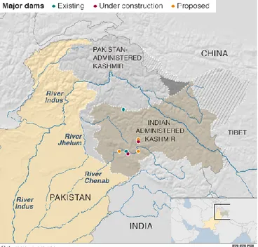
From the above discussion, it should be easy to grasp a fundamental truth of the Kashmir dispute – namely, its intimate relation to the Indus system waters. Indeed, no harm would be done to the truth were we to speak as often of the Indus dispute as of the Kashmir dispute: in many respects, they are one and the same (Adeel & G.Wirsing, 2017). In the process of partition of the province Punjab comprising of sub districts of Zira and Ferozpur, both of much were Muslim majority and, thus, should ordinarily have gone to Pakistan were intentionally demarcated in the Indian territory. Moreover, in these sub- districts were important head works controlling the flow of the Sutlej River, a major source of irrigation water for both Indian and Pakistani Punjab. And so it was New Delhi’s apprehensions over water, it appears, that were responsible for the results of the secret meeting between Mountbatten and Radcliffe – what Beaumont said had brought “grave discredit on both men” (Kaushik, 2015), (Wirsing, 1998). Figure 2-2 shows the geographical location of Kashmir and also highlights the Indian occupied Kashmir i.e. Jammu & Kashmir (J&K) and Pakistan administered part of Kashmir i.e. Azad Kashmir (AK).
15
Over the nearly 70 years since it began in 1947, the Kashmir dispute has become a massive tangle of issues, some of them leading on a number of occasions to open warfare, having to do with much more than just water. But that “the river runs through it,” to borrow from the title of Norman Maclean’s 1976 novella, has been equally true. Indeed, there is no little irony in the fact that the dissatisfaction of Kashmiri Muslims with their post-Partition political fate has been increasingly expressed in recent years not merely as a demand for self-determination but also as frustration with not having a meaningful role in management of the Indus river system originating in their state (Adeel & G.Wirsing, 2017). They were not consulted, they say, when the Indus Waters Treaty was drawn up, and the partitioning of the rivers resulting from that treaty leaves them essentially voiceless in regard to how those rivers are now exploited. Commenting on the IWT not long ago, a chief minister of the state reportedly declared it to be “the biggest fraud with the people of Jammu and Kashmir” (Haider, 2014). Despite being the dominant upstream riparian of the Indus, there is a strong sense of grievance in Jammu and Kashmir that the treaty has deprived the state of its huge hydroelectric potential (Briscoe, 2010), making it very difficult for the state to derive any major benefit by way of irrigation, hydroelectric power or navigation from the rivers that flow through it but stand allocated to Pakistan (Iyer, 2010). The Kashmiris are complaining that the Indus Water treaty (IWT) between India and Pakistan has deprived them from using the water flowing through their own land (Ashraf, 2012). The sharing of water has thus become one of the major irritants between India, Pakistan and the Kashmiri people (Khan & Shakir, 2011). The people of Kashmir are vehemently against the IWT treaty, which according to them has made them a sacrificial goat. Kashmir annually losses 60 billion Indian rupees (US$1.3 billion) on account of the prohibitions of this treaty by virtue of which Kashmir cannot store water for generating electricity or for irrigation purposes (Mirani, 2009). The Indus Water Treaty has ill-effects on the Jammu and Kashmir’s energy harnessing potential and it creates challenges for the setting up of new power projects in the state.
“Jammu and Kashmir is facing acute problem on harnessing its hydropower potential due to the restrictions of the IWT. People complain that for every hydropower project, a clearance from Pakistan needs to be sought and despite
fulfillment of all formalities, objections from the other side never end. There is a recurring loss of Rs 265 crore annually in Baghliar due to IWT and the total losses are over Rs 3325 crore on Chenab basin. India surrendered rivers originating from the Kashmir to Pakistan at the cost of J&K’s interests. The eastern states are progressing at
the cost of Jammu and Kashmir”.
These are the views that were expressed by Zahoor Ahmad Chat-Executive Director J&K State Power Development Corporation at a hydropower conference in J&K (Ali, 2012). The Indus Waters Treaty (IWT) It has been argued that the general perception that India is threatening the survival of Pakistan simply by “cutting off” the water of the Indus raises the potential of Pakistan using nuclear weapons as a last resort (Brennan, 2008).
Among them is the likelihood that Indians and Pakistanis won’t be on the same page, differing not only on the need for change but also on its preferred contents. Serious consideration would have to be given to whether the IWT should remain a bilateral treaty or be widened to include one or both of the other two riparian countries, also to the question of whether it might be wiser to abandon the notion of a comprehensive agreement and negotiate instead separate agreements on such things as water quality, groundwater exploitation, disaster resilience, environmental protection, and so on (Adeel & G.Wirsing, 2017). These current scenarios envisage a climacteric puzzle of water commodification immersed in antagonism and mistrust. Following section underpins the importance of Indus basin in the world.
16
2.4 Importance of Indus Basin in the World
Cooperation among the riparian states of the Indus basin in the common quest for overcoming water insecurity is every bit as important to the world community as it is to the basin’s riparian states. A few reasons have been listed below in this regard.
The first is that the Indus basin riparian states rank exceptionally high on world indicators of great power status. Two of the four (China and India) rank first and third among the three largest economies in the world – one of them (China) having overtaken the USA as the world’s largest economy by the end of 2014 (Stiglitz, 2014).
The second is that the probability of armed conflict among the riparian states, exacerbated by the expected increase in resource scarcity and intensified resource rivalry, is unquestionably among the highest in the world. This doesn’t mean that water wars are soon bound to break out in the Indus basin, though some of the area’s best scholars seem to think so (Adeel & G.Wirsing, 2017).Adeel and Wirsing asserts, however it does mean that a decent allowance has to be made for water scarcity’s inclusion on the list of things the Indus basin’s riparian states quarrel about and their quarrels have often enough ended in war. We may note in this regard that all four of the riparian states already have a history of armed conflict, whether direct or by proxy, with one or more of their riparian neighbors in the last half century or so (India with both Pakistan and China, Afghanistan with Pakistan).
The third is that there is clearly considerable risk of political instability arising from water scarcity in at least one of the Indus basin riparian states (Pakistan). Pakistan’s especially bleak water statistics were highlighted in a Deutsche Welle interview in February 2015 with Michael Kugelman, South Asia expert at the Woodrow Wilson Center in Washington, DC, who offered up a breathtaking litany of Pakistan’s water woes. Pakistan, he said, has the fourth highest rate of water use in the world; and its water intensity rate (the amount of water, in cubic meters, used per unit of gross domestic product) is the highest in the world. It is, he said, the third most water-stressed country in the world, and its per capita water availability per annum, estimated at 1017 cubic meter, puts it just a hair above the widely accepted and much-dreaded scarcity threshold of 1000 cubic meter per capita per annum (Domínguez, 2015). The potential impact of all this on Pakistan’s ability to keep pace economically with the parallel massive increase in population we’ve already taken note of is ominous. No surprise, then, that a recent International Monetary Fund assessment is that water scarcity may threaten all aspects of the country’s economy (Khokhar, 2013).
The forth reason emphasize here with another scientific research in regards to precise effect of hydro-climatic change on the basin. This is especially the case when it comes to the matter of glacial retreat/melt, a recent and technically sophisticated World Bank report on the impacts of climate risks on the Indus basin begins the discussion with a warning that “considerable speculation but little analysis exists concerning the importance of glaciers in the volume and timing of flow in the Indus River and its tributaries, as well as on the potential impact of climate change on these rivers” (Yu, et al., 2013). The fifth is that the region in which the Indus basin is located collectively represents enormous market size and business opportunities. This is implied, of course, in the mention we made above of the global economic rankings of China and India. Trade and investment opportunities are enormous in both. China,
17
for instance, ranks second (behind Canada and before Mexico) and India ranks 9th in total trade volume, imports and exports, among America’s top 15 trading partners ( U.S. Census, 2017).
The sixth is that the spillover effects of all of the above on the rest of the world cannot be contained and are likely to be sizeable. The basin’s occupants are just too large, too important, and too integral a part of world affairs for their water woes to be simply swept aside as a matter of little consequence (Adeel & G.Wirsing, 2017).
As the background is expanded by including a wide range of empirical research with the backdrop of the water security the theory of political ecology has been incorporated in the coming scetions. While harboring in the political ecology perspective the work of Swyngedouw and Mustafa are highlighted which pertain to the relationship of power and natural resources. But first the methodologies used in addressing the research questions are described in the next section.
18
Chapter 3: Methodology and Research Approach
3.1 Methodology Overview
Methodological framework of this dissertation is designed according to both its aim and research questions as well as theoretical lens which pertain to the relationship of politics and natural resources. Moreover to unleash the synergies between nature and power this chapter discusses ideas behind such approach, describes applied methods for data gathering and analysis, validity of results and limitations.
3.2 Method of Data Collection
This dissertation conducts qualitative case-study research in which literature review for data collection has been taken as the primary method. The literature reviews on; water security, urban political ecology, scale and physical geography and conflict surrounding trans-boundary water management is conducted for the basic understanding of the topic.
Consequently, data will be drawn from second-hand sources, such as academic books and journals, surveys and reports from think-tanks and organizations as well as official governmental documents and structural interviews. We also include popular media (newspapers and online magazines) as these are tools for elites (powerful) in constructing specific self-serving perceptions by communicating with civilian society and stakeholders alike (Alam, et al., 2011). Speeches, statements and comments regarding Indus basin and Ravi Riverfront project are also highlighted.
The second method which is adopted to address the issue of water commodification is structural interviews. A group of carefully selected people are contacted from the Public and private sector to grasp the whole scenario in detail. These structural interviews were documented through email conversation and also through Media programs which pertains the same issues as those which are discussed in this dissertation.
Interviewee 1 – Referred to as Government representative
The Mayor of Lahore i.e. Nazim-e-Lahore is the one who heads the Metropolitan Corporation Lahore (MCL) which controls the Local Government system of Lahore.
Interviewee 2 – Referred to as Public representative
The representative work in Lahore Development Authority (LDA) and have worked in the project of Ravi upfront development project.
Interviewee 3 – Referred to as Private Representative
The representative works as General Manager NESPAK (National Engineering Services of Pakistan) and
19
Thus, the main types of sources used in this dissertation are shown in Table 3-1.
Type of Data Use in Study
Academic Books and Journals
Obtain required theoretical knowledge (e.g. water security, hydro-politics and land commodification). Obtain required empirical knowledge and data for analysis News Articles Obtain data for analysis
Reports from NGOs, Think-Tanks, etc. Obtain data for analysis Official Documents Obtain data for analysis
Interviews (2nd source) Primarily gathered through media programmes and email conversation
Table 3-1: Data Sources
3.3 Method of Data Analysis
3.3.1 Applying Case Studies
Case study research is the investigation of an issue examined through one or multiple cases, within a limited setting or context (Creswell, 2012). To unravel the concepts, South Asian context is used in this dissertation. Moreover, this approach entails a number of advantages for the interpretive researcher, such as the contextualization and operationalization of qualitative variables, and, with the support of sound theory, the identification of causality in highly complex relations (Sprinz & Wolinsky-Nahmias, 2004).
3.3.2 Choice of Case Studies
The case of Indus basin has also been chosen because a recent United Nations Security Council (UNSC) report has identified a number of potential flash-points for future conflicts over water, with the Indus Basin appearing high on the list. Continued population growth and drought from global warming will instigate enormous pressure on water resources – 40 per cent of the globe’s population is already short of fresh water and given current trends, this will rise to 50 per cent by 2030 and could be as high as 90 per cent in the region stretching from Maghreb to West Asia to the western part of India and Pakistan (Sinha, 2005). For studying the structural and absolute water scarcity connecting to water security the case of Indus basin seems highly relevant. In the similar nerve the case of river Ravi being a recent intervention blends well with the picture of water commodification in South Asian context.
3.4 Scope and Limitations
The main limitation of this research, however, is the reliance on secondary data. Reliance on secondary data is particularly significant in this instance because the Trans boundary water relations are difficult to research, especially when they are contentious, as Allan and Mirumachi caution, “The level of difficulty in carrying out research on Trans-boundary waters is directly proportional to the intensity of the contention over shared waters” (Allan & Mirumachi, 2010). There are a significant number of issues with this kind of representation. Firstly, such a framing clearly elides a range of significant issues occurring inside the nation-state, including the differential impact of any planned developments
20
between upper and lower riparian provinces within the same country (e.g., such as between Punjab and Sindh). Secondly, by confining the debate only to what happens to the watercourse, the relationship to broader ecosystem services is often simplified. This is particularly significant both for biodiversity and for people whose cultural or social relationship with the water from the basin may be broader than just withdrawals for irrigation. Thirdly, by limiting notions of what constitutes security to the capacity of the sovereign state to enforce its territorial integrity against other sovereign states, security is defined in a very reductive manner that elides the issues of human or nontraditional security, which are nevertheless extremely pressing for many people in the Indus basin alike (Adeel & G.Wirsing, 2017).
This chapter elucidates the approach behind the research design, choice of instruments for data collection and analysis and explains limitations of such approach. The next chapter presents a detailed analysis of factors pertaining to water commodification encompassed by the Indus basin and River Ravi.
21
Chapter 4: Theories and concepts
After providing a comprehensive overview with a nuance of its complexity at local, national and regional level, the limits of this literature are set for exploring the whole problem in the political ecology perspective. Particularly in the political-ecology tradition, power relations are held to be instrumental in the production and maintenance of water resources and hazards geographies (Mustafa, 2002). Despite this recognized centrality of power relations in determining resource management, political ecologists have used mode of production, political economy, or social discourses as surrogate concepts to apprehend the role of power (for example, (Blaikie, et al., 2003), (Hewitt, 1997), (Swyngedouw, 1999). The uses of the above surrogate concepts to apprehend the role of social power have considerably enhanced our understanding of resource geographies (Mustafa, 2002). The assumptions of the geopolitical understanding of water have as much to do with the limits of theory as they do with the concrete understanding of the empirical function and role of water. The issue of water commodification engulfing the waterscapes has been portrayed in this dissertation. Water is indeed a commodity and its relative scarcity indeed has an important relationship to the politics of conflict that may surround it (Burgess, et al., 2016). Hence the concept of urban political ecology is considered highly relevant for exploring the synergies of power control of natural resource.
4.1 Urban Political Ecology
In dictionary “Political Ecology” is referred as an umbrella term for a variety of projects that involve politics and the environment, including attempts to study politics using the language and methods of ecology, the study of political struggles for control over natural resources, and research on biodiversity and natural resource exploitation that is intended to inform public policy (Park & Allaby, 2017). Urban political ecology is defined by Swyngedouw and Heynen as “the political programme of urban political ecology is to enhance the democratic content of socio-environmental construction” (Swyngedouw & Heynen, 2010). Political-ecological perspectives seek to unravel the nature of the social relationships that unfold between individuals and social groups and how these, in turn, are mediated by and structured through processes of ecological change. In other words, environmental transformation is not independent from class, gender, ethnic, or other power struggles (Swyngedouw, 2004). Moreover Heynen (Heynen, et al., 2006) also calls for ‘more equitable distribution of social power and a more inclusive mode of the production of nature.’ Swyngedouw underpins that under capitalist social relations, the metabolic production of use values operates in and through specific control and ownership relations and in the context of the mobilization of both nature and labor to produce commodities (as forms of metabolized socio-natures) with an eye towards the realization of the embodied exchange value . His Idea of the circulation of capital as value in motion is, therefore, a combined metabolic transformations of socio-natures in and through the circulation of money as capital under social relations that combine the mobilization of capital and labor power. He envisages new socio-natural forms as continuously produced as moments and things in this metabolic process while nature provides the foundation, the dynamics of social relations produce nature’s and society’s history. Whether we consider the production of dams, the re-engineering of rivers, the transfiguration of DNA codes, or the construction of a skyscraper, they all testify to the particular capitalist social relations
22
through which socio-natural metabolisms are organized (Swyngedouw, 2004). Everybody and everything is a cyborg, a mediator, part social, part natural, lacking discrete boundaries and internalizing the multiple contradictory relations that redefine and rework them (ibid). He asserts that the political ecological examination of the urbanization process reveals the inherently contradictory nature of the process of socio-environmental change and teases out the inevitable conflicts (or the displacements thereof) that infuse socio-environmental change.
With the backdrop of commodified nature Swyngedouw juxtaposes urban political ecology in the ‘uneven urban landscapes’, unraveling the power-laden socioecological relations that go into the formation of urban environments constantly shifting between groups of actors and scales (Swyngedouw & Heynen, 2010).
4.2 Urban Political Ecology and Scale
Oozing out of Marxist-inspired political economic theories of the space economy, Smith, Swyngedouw stresses the production of scale i.e., how economic and political processes shape the emergence of scale. Processes include the geographic strategies of capitalist firms, of political institutions such as the nation-state, and of labor organizing to improve livelihood conditions in the face of challenges posed by capital mobility and/or state strategies (Swyngedouw, 2004). Neil Smith and Ward Dennis (Smith & Dennis, 1987) argued that the greatest variability in uneven development within the United States shifted during the 1970s from a regional (sunbelt-snowbelt) scale to more localized scales, as a result of an increased emphasis on interurban and interstate competition for investment, and a devolution of the responsibility for achieving and maintaining economic prosperity from the Federal to the US-state and local scales. Whereas weaving urban societal and material arrangements with scale Swyngedouw connotes that the dynamics of socio spatial and environmental changes are embedded within network or territorial scalar configurations that extend to local milieu to global relations. The priority, both theoretically and politically, therefore, never resides in a particular social or ecological scale; instead, it resides in the socio-ecological process through which particular social and environmental scales become constituted and subsequently reconstituted (Swyngedouw, 2004). In other words a complex scalar articulation arises from the molecular processes and dynamics associated with the circulation of the capital and its associated socioecological, metabolic transformation processes, on one hand, and the levels of scales of regulation and governance in which they are embedded on the other (Swyngedouw & Heynen, 2010).
Scale is critical in assessing water security because of the scalar variability of hydrology, as illustrated by a recent study (Cook & Bakker, 2012). A process-based approach to scale focuses attention on the mechanisms of scale transformation through social conflict and political-economic struggle. The scale redefinitions in turn alter the geometry of social power by strengthening the power and the control of some while disempowering others (Swyngedouw, 2004).The concept of scale is also entailed to highlight the politics which revolves around the access, equity and distribution of water in the Indus basin. It has been envisaged through the selection of two case studies. Firstly on the larger scale, the trans-boundary Indus basin shared by two riparian states India and Pakistan is discussed with the lens of political ecology. Whereas the smaller scale has been showcased by providing the project of River Ravi Upfront Development and unveiling the meshes of politics engulfed in this waterscape. The selection of both